
ABSTRACT
This study presents the first detailed glacial geomorphological map of the sediment-landform assemblages formed by three eastern outlet glaciers of the former Patagonian Ice Sheet. These glaciers occupied the Río Corcovado, Río Huemul and Lago Palena/General Vintter valleys, Chubut province, Argentina (43°S, 71°W). By combining remote sensing and field-mapping, we build on previous ice-sheet scale mapping and geological surveys to provide high-resolution spatial information on local ice-contact glaciogenic, glaciofluvial, glaciolacustrine, and subglacial landforms. Twenty-five landform types, many of which are newly mapped in the region, were digitized as georeferenced shapefiles over a 5300 km2 area. This map enables the identification of former ice-flow directions, relative ice-margin positions and glaciofluvial drainage pathways for each preserved Quaternary glaciation. It also elucidates the former areal extent, geolocation and spillways of glaciolacustrine bodies formed during the last deglaciation. The map delivers an essential framework on which to build robust glacier-scale geomorphological and geochronological reconstructions.
1. Introduction
The Patagonian region of southern South America was host to the most extensive Quaternary ice sheet of the southern hemisphere outside of Antarctica, the Patagonian Ice Sheet (PIS). The PIS covered a latitudinal extent of ∼2000 km (38°S–56°S; ) along the spine of the Patagonian and Fuegian Andes (CitationCaldenius, 1932; CitationDavies et al., 2018, Citation2020; CitationGlasser et al., 2008; CitationMartínez et al., 2011). Patagonia is part of the only continental landmass that fully intersects the precipitation-bearing southern westerly winds (CitationGarreaud et al., 2013) and is one of few regions in the southern mid-latitudes containing a well-developed Quaternary glacial geomorphological record (CitationClapperton, 1993; CitationGlasser et al., 2008). Patagonia therefore offers a unique opportunity to study Quaternary climatic and environmental change in the southern mid-latitudes.
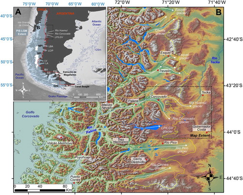
Figure 1. Geographical and glaciological context of the study area. (A) Approximate former extent of the Patagonian Ice Sheet (PIS) at the Last Glacial Maximum (LGM), redrawn after CitationGlasser et al. (2008) and CitationGlasser and Jansson (2008). Overlain in white are the contemporary North Patagonian (NPI), South Patagonian (SPI), and Cordillera Darwin (CDI) Icefields. Major eastern PIS glaciers are designated; BI: Bahía Inútil, EM: Estrecho de Magallanes, SS: Seno Skyring, BV: Bella Vista, LA: Lago Argentino, LV: Lago Viedma, LC/P: Lago Cochrane/Pueyrredón, LBA: Lago Buenos Aires. Bathymetric data of ocean basins were obtained from the General Bathymetric Chart of the Oceans (GEBCO) and are displayed in greyscale. A −125 m contour line is applied to simulate the approximate former position of coastlines at the LGM (CitationLambeck et al., 2014). The Chile/Argentina border is highlighted in red. (B) Digital elevation model (DEM) of northern Patagonian region from the ALOS WORLD 3D missions (version 2.2; JAXA; https://www.Eorc.jaxa.jp/ALOS/en/aw3d30/) with a shaded relief background and a black sea level contour line highlighting modern coastlines . White arrows indicate former ice-flow of major northeastern PIS outlets, including the Río Corcovado, Río Huemul and Lago Palena/General Vintter glaciers. The yellow line designates the contemporary Atlantic/Pacific drainage divide. Lake bodies and key river channels are drawn in blue. The black dotted box delineates the extent of the geomorphological map presented with this paper.
Robust palaeoglaciological reconstructions of PIS outlet glaciers can help us to investigate the landscape evolution and climate-forcing mechanisms responsible for Quaternary ice-sheet fluctuations (e.g. CitationHein et al., 2010; CitationRabassa et al., 2000). They can provide insights into the timing and causes of Quaternary glacial cycles in the southern mid-latitudes, and enable determination of the regional drivers of glaciation as well as inter-hemispheric glacial (a)synchronicity (CitationBentley et al., 2005; CitationDenton et al., 1999; CitationGlasser et al., 2008). For these reasons, the PIS has been subject to an increasing number of glacial geochronological reconstructions. However, with a few exceptions (e.g. CitationGarcía et al., 2019; CitationIglesias et al., 2016; CitationVan Daele et al., 2016) there remains a general lack of published detailed mapping and geochronological data across the northeastern sector of the former ice sheet, between ∼39°S and ∼46.5°S (CitationDarvill et al., 2015; CitationDavies et al., 2020; CitationMendelová et al., 2017). Robust reconstructions from this region are needed to understand fully the PIS response to the Last Glacial Maximum (LGM) at these latitudes, and to investigate latitudinal dependencies on the timing of the local LGM throughout Patagonia (CitationDarvill et al., 2015; CitationDavies et al., 2020; CitationGarcía et al., 2018; Citation2019; CitationSagredo et al., 2011). A vital component of such reconstructions is detailed, glacier-scale geomorphological mapping (CitationChandler et al., 2018; CitationClark et al., 2018; CitationEvans & Orton, 2015). This provides spatial information that facilitates interpretations of palaeoglaciological behaviour and equips glacial geologists with an essential framework upon which to build robust chronologies (CitationChandler et al., 2018; CitationBendle et al., 2017a; CitationDarvill et al., 2016). We thus present in this paper the first detailed glacial geomorphological map of three valleys in northeastern Patagonia (43.5°S), the Río Corcovado, Río Huemul and Lago Palena/General Vintter valleys (b). Our aim is to provide benchmark geomorphological data for future geochronological interpretations of their glacial history.
2. Study location and previous work
The geomorphological map is centred on a region located east of the Patagonian Andes, between 43.3°S and 44.0°S, and covers an area of ∼5300 km2 (b). At these latitudes, a major westward-dipping over-deepened valley, the Río Palena trough, cuts through the Andes to drain the contemporary Río Corcovado, Río Huemul and Lago Palena/General Vintter catchments westward to the Pacific Ocean. At this location, the PIS was characterised by ice flowing towards the east-northeast from the centre of the former ice sheet, located near Macizo Nevado. Glacier ice thus flowed along the Río Palena trough to the mountain front, where it diverged into two glaciers occupying the Río Huemul valley to the east, and the Río Corcovado valley to the south (b). The two outlet glaciers extended up to 60 km to the east and southeast of the Argentinian town of Corcovado (43°54′S; 71°46′W) (CitationCaldenius, 1932; CitationHaller et al., 2003; CitationMartínez et al., 2011). Here, we refer to these as the Río Huemul glacier and the Río Corcovado glacier; the latter to distinguish it from the Golfo Corcovado outlet glacier that drained the western side of the PIS (CitationDenton et al., 1999). The Lago Palena/General Vintter outlet glacier drained a separate, smaller catchment located ∼30 km southeast of the Río Palena trough. This glacier flowed eastward, at times extending to converge with the Río Corcovado glacier coming from the north (). Subsequent retreat into an over-deepened basin led to the formation of the moraine-dammed Lago Palena/General Vintter lake, still present to this day (43°55′S; 71°31′W) (). Our mapping focuses on the former terminal environment of these three outlet glaciers. Subglacial erosion and over-deepening of the Río Palena trough is greater towards the centre of the former PIS where ice thickness and duration of ice cover were largest (CitationClapperton, 1993; CitationHubbard et al., 2005; CitationKaplan et al., 2009). Thus, at our study site, asymmetrical subglacial erosion generated a progressive eastward migration of the Atlantic-Pacific drainage divide following each Quaternary glaciation, causing the contemporary drainage divide to be located ∼70–80 km east of the central spine of the Andes (CitationDavies et al., 2020; CitationKaplan et al., 2009) (). The semi-arid eastern sectors of the Río Corcovado, Río Huemul and Lago Palena/General Vintter valleys, which belong to the Patagonian steppe climate zone, are characterised by extensive, well-preserved and easily discernible moraine complexes, along with their associated glaciofluvial and glaciolacustrine sediment-landform assemblages (CitationHaller et al., 2003; CitationMartínez et al., 2011).
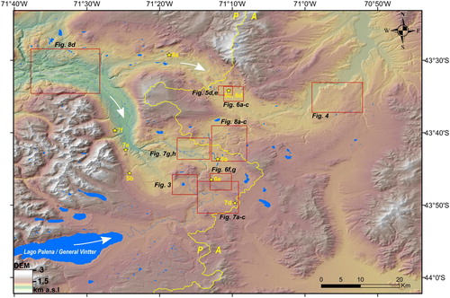
Figure 2. Digital elevation model (AW3D30 and hillshade) showing the area covered by the map presented with this paper. Locations of imagery / geomorphology comparison maps presented in are shown by red boxes. Locations of photographs presented in are indicated with yellow star symbols. The Atlantic (A) / Pacific (P) drainage divide is delineated in bright yellow, while ice-flow direction of the Lago Palena/General Vintter, Río Corcovado and Río Huemul glaciers is indicated by the white arrows. The Río Corcovado and lakes / water bodies are mapped in dark blue.
Geomorphological mapping of major moraine limits in the Río Corcovado, Río Huemul and Lago Palena/General Vintter valleys was conducted by CitationCaldenius (1932), CitationGlasser and Jansson (2008), and CitationDavies et al. (2020), in their respective efforts to record the glacial geomorphology of the entire PIS (). CitationHaller et al. (2003), meanwhile, produced a regionally-focused geological map of the three valleys including main glaciogenic deposits (area located between 43–44°S and 72–70.3°W). These deposits were also mentioned in studies by CitationLapido (1990) and CitationMartínez (2002; CitationMartínez et al., 2011). However, all previous mapping was part of ice-sheet-wide geomorphological investigations or geological surveys and was focused primarily on identifying the most prominent moraines and glaciofluvial deposits for each glaciated valley. All previous studies interpreted the landforms as Pleistocene glaciogenic deposits associated with three distinct glaciation events, with the innermost preserved moraines suggested to relate to the local LGM. However, the ages of Río Corcovado, Río Huemul and Lago Palena/General Vintter deposits were inferred solely from morpho-stratigraphic observations and comparisons with other dated Patagonian records (e.g. the Lago Buenos Aires record, 46.5°S), with numerical dating yet to be applied. Here, we thus undertake the first detailed mapping of the complex glacial sediment-landform assemblages preserved in the three valleys. This work will serve as a geomorphological framework for new geochronological reconstructions in progress.
Table 1. Summary of mapped glacial landform morphologies, identification criteria from remote sensing, mapping uncertainties and previous mapping conducted in the Río Corcovado, Río Huemul and Lago Palena/General Vintter valleys.
3. Methods
3.1. Remote sensing
Initial identification of major landforms and topographic features was conducted using the ALOS WORLD 3D – 30 m resolution (AW3D30) Digital Elevation Model (DEM) (version 2.2; https://www.Eorc.jaxa.jp/ALOS/en/aw3d30/) (). Hillshade backgrounds of different azimuths were produced using ArcGIS (v10.5), along with topographic contour lines. When displaying significant positive relief (>15 m), cross-section elevation profile graphs were generated to further distinguish major landforms according to their morphometry. All mapped landforms were digitised manually in the WGS84 geographic reference coordinate system using the ESRITM World Imagery layer, characterised by 1.0 m resolution images from DigitalGlobe (GeoEye, IKONOS, 2000–2011) at the study site. To increase landform identification potential, three-dimensional views of this imagery layer were produced in the ‘Windows Maps’ application (Microsoft Corporation). In areas with high vegetation cover, different colour-rendering comparisons were made using 10 m resolution Sentinel 2A true colour (TCI) and false colour (bands 8,4,3) products (https://scihub.copernicus.eu/). Similar mapping methodologies were used by CitationMartin et al. (2019), CitationDarvill et al. (2014), CitationBendle et al. (2017a), CitationMendelová et al. (2020) and CitationSoteres et al. (2020) to conduct high spatial resolution glacial geomorphological mapping of other Patagonian regions.
3.2. Field mapping
Field mapping was conducted over the austral summers of 2018 (Lago Palena/General Vintter only), 2019 and 2020 (all three valleys). Fieldwork focussed primarily on ground-truthing and/or corrections of preliminary landform interpretations, with additional geomorphological mapping undertaken in key accessible locations (CitationChandler et al., 2018). To aid understanding of landform genesis, landform sedimentology was also analysed where possible.
4. Results
4.1. Glacial geomorphology
The glacial geomorphology in the study area records the terminus positions of the Río Corcovado, Río Huemul and Lago Palena/General Vintter outlet glaciers over multiple glacial cycles. Glacial depositional and erosional features thus heavily dominate the three valleys’ geomorphological records. Our mapping reveals twenty-five landform types, classified and manually digitised as polyline and polygon shapefiles (). These comprise seventeen glacial geomorphological landform types, including a variety of ice-contact glaciogenic landforms (e.g. moraines, hummocks), glaciofluvial (e.g. outwash plains, meltwater channels), glaciolacustrine landforms (e.g. palaeo-shorelines, raised deltas) and subglacial landforms (e.g. ice-moulded bedrock, lineations). Identification criteria for these seventeen landforms are described below, and uncertainty assessments related to landform identification are summarised in . The map also features six geomorphological features providing wider geographical context, including empty cirques, alluvial fans, rotational slumps or landslides, and modern hydrological features (e.g. rivers, lakes etc.). Furthermore, a polyline delineates the contemporary Atlantic-Pacific drainage divide, extrapolated from the DEM ().
4.2. Ice-contact glaciogenic landforms
4.2.1. Moraine complexes and kettle-kame topography
We differentiate here between two types of ice-contact glaciogenic sediment composites. Relatively confined, narrow (<3 km wide) and easily discernible sediment complexes of arcuate shape comprising prominent and continuous moraine ridges (Section 4.2.2), as well as concentrated, hummocky ridges in parallel to each other (Section 4.2.3), are here termed moraine complexes (). In contrast, large (>3 km) deposits composed of chaotic hummocks (or kames) irregularly interspersed with hollows and kettle holes, presenting few moraine ridges and low concentrations of hummocky ridges, are here defined as kettle-kame topography (CitationDarvill et al., 2014; ). Although both composites essentially highlight former glacier margins, we feel that it is important to distinguish between their dissimilar morphologies to highlight possible variability in former ice-marginal environments (e.g. CitationBenn & Clapperton, 2000; CitationDarvill et al., 2014; CitationRaedeke, 1978). In contrast to well-defined moraine complexes diagnostic of the less extensive, younger deposits (), the most distal deposits discernible from imagery and in the field in the Río Huemul valley consist of a large belt of kettle-kame topography, previously termed the ‘Tecka drift’ (CitationHaller et al., 2003; CitationLapido, 1990; CitationMartínez et al., 2011) (). Consequently, differentiating between distinct glaciogenic sediment compounds morphologies in our mapping can prove useful when producing subsequent geomorphological interpretations of local palaeoglaciological behaviour (CitationDarvill et al., 2014).
Figure 3. (A) Satellite imagery (ESRITM, DigitalGlobe) and (B) glacial geomorphological mapping comparison (contour lines interval: 30 m) of two-closely-spaced, well-defined terminal moraine complexes located in the Río Corcovado valley, to the east and southeast of the Arroyo El Fango headwaters. Despite being closely-spaced, the two moraine complexes are separated in most parts by a distinct proglacial outwash plain deposit which suggests that the innermost moraine complex represents a younger re-advance or still-stand of the Río Corcovado outlet glacier. See for location.
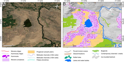
Figure 4. (A) Satellite imagery (Sentinel 2A TCI image 02/03 2018) and (B) glacial geomorphological mapping comparison of the Tecka Drift (as termed by CitationHaller et al., 2003; CitationLapido, 1990; and CitationMartínez et al., 2011) located to the east of the Río Huemul valley. This deposit is characterised, unlike moraine complexes, by a chaotic and extensive array of ice-contact glaciogenic mounds such as hummocks and hummocky ridges with low parallelism, interspersed with numerous kettle-holes and large (>30 m wide) former meltwater channels. Such a low-gradient deposit is diagnostic of a stagnant, progressively thinning ice front (dead-ice scenario), and was here mapped as kettle-kame topography. See for location.
4.2.2. Moraine ridges
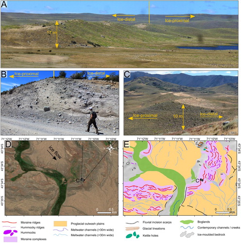
The eastern sector of the mapped area exhibits numerous well-preserved landforms identified as linear- to arcuate-shaped, steep-sided (20°–40°) ridges displaying positive relief (5–45 m), a clear break-of-slope, and sharp undulating crests. Such features were interpreted as moraine ridges (CitationBenn & Evans, 2014) delineating former lateral and terminal ice-front margins; the moraine crests were mapped as polylines. Moraine ridges in the field can occur as well-preserved, cross-valley continuous ridges outlining former latero-terminal ice margins over several kilometres (). However, they can also occur as fragmented, discontinuous and shorter ridges (a few hundred metres in length), clustered alongside multiple, smaller hummocky features. Well-preserved, prominent and continuous moraine ridges can be discerned from the DEM due to their significant positive relief and arcuate shape (). Such moraine ridges are characteristic of the innermost moraine sequences of the Río Corcovado, Río Huemul and Lago Palena/General Vintter valleys, which are likely associated with the local LGM (CitationLapido, 1990; CitationMartínez et al., 2011; a,c). The older, more distal moraine complexes are morphologically distinct and characterised by wider, more subdued and broad-crested ridges. They also display lower slope gradients, making them more challenging to distinguish and map from imagery. In such older environments, identifying ice limits can be problematic, and often requires the adjacent detection of other proglacial deposits such as kettle holes, meltwater channels and proglacial outwash plains, which on the Argentine forelands tend to remain better preserved than moraine ridges due to lower erosion and mass-wasting potential (CitationDunai, 2010; CitationHein et al., 2009, Citation2011). Thus, fewer prominent, continuous moraine ridges could be mapped for the older, most extensive moraine complexes of the study site.
Figure 5. (A) View towards the south/southeast of a well-preserved, prominent terminal moraine in the eastern Río Corcovado basin (camera location: 43°43′40.64″S, 71°12′2.48″W). (B) Photograph of a road-cut section through a well-preserved latero-terminal moraine ridge of the Río Corcovado palaeoglacier western margin displaying glacio-tectonic till structures (location: 43°45′37.99″S, 71°24′9.06″W). (C) View towards the northeast as indicated on panel D (camera symbol) of a well-preserved terminal moraine ridge in the Río Huemul valley. (D) Satellite imagery (ESRITM, DigitalGlobe) and (E) glacial geomorphological mapping comparison of the well-preserved terminal moraine ridges located in the Río Huemul valley forming a well-defined arcuate moraine complex. Panels (D) and (E) also display two extensive proglacial outwash plains to the southeast (time-synchronous with photographed moraine – panel (D)) and the northwest (younger than photographed moraine) and exhibiting braided former meltwater channels. See for location.
4.2.3. Hummocks and hummocky ridges
Throughout the three valleys mapped in this study, we find an abundance of rounded to sub-rounded mounds of glaciogenic sediments, often termed hummocks in glacial geomorphology (CitationBenn & Evans, 2014). When hummocks are arranged in short (<300 m wide) ridges of limited relief (<30 m), they are often described as hummocky ridges/moraines (CitationDarvill et al., 2014; CitationEyles et al., 1999). Hummocky ridges were mapped as polylines along identified crestlines while distinct hummocks were mapped as polygons. These features are widespread throughout our study site and occur as; (1) isolated features in kettle-kame topography, where their linearity often originates from supraglacial or ice-contact glaciofluvial deposition (CitationDarvill et al., 2014), or (2) ridges observed in latero-terminal moraine complexes, clustered in parallel successions orientated perpendicular to ice flow, sometimes alongside prominent moraine ridges (e). In this latter case, hummocky ridges are likely to represent discontinuous recessional moraines, eroded and diminished by meltwater runoff (CitationClapperton et al., 1995; CitationEyles et al., 1999). On the other hand; abundant, highly concentrated, parallel- and perpendicular-to-ice-flow hummocky ridges can indicate a relatively stable ice margin, such as observed within the well-defined younger terminal moraine complexes located in the Río Corcovado valley, to the southeast of the Arroyo El Fango headwaters (a,b).
4.2.4. Kettle holes
In both moraine complexes and kettle-kame topography of the Río Corcovado, Río Huemul and Lago Palena/General Vintter valleys, numerous examples of circular to semi-circular hollows and dry pits of shallow depth (<20 m) can be observed chaotically dispersed within hummocky terrain. We interpreted these features as kettle holes, which are landforms commonly associated with slowly retreating or stagnant glacier fronts (CitationEvans & Orton, 2015; CitationPrice, 1969; CitationRussell et al., 2006). Kettle holes are typically formed through burial of ice blocks by till and glaciofluvial sediments, leading to the formation of enclosed rounded depressions near the ice-margin as the ice block subsequently melts (CitationBenn et al., 2007; CitationKnight, 2011). depicts a complex of kettle holes distributed across kettle-kame topography within the southeastern latero-terminal margin of the former Río Huemul glacier (43°40′S; 70°55′W).
4.3. Glaciofluvial landforms
4.3.1. Proglacial outwash plains
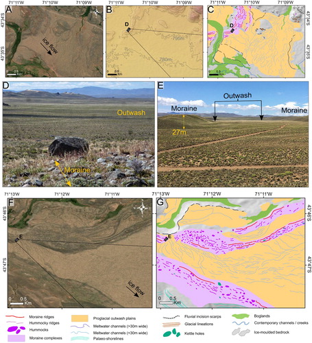
Glaciofluvial outwash plains are characterised by broad, low-gradient surfaces composed of fluvially-rounded sands and gravels (CitationAlloway et al., 2018; CitationDarvill et al., 2015; CitationDenton et al., 1999; CitationEvans & Orton, 2015; CitationHein et al., 2009). They often occur adjacent and down-valley to latero-frontal moraine systems and are sometimes associated with the presence of palaeo-meltwater channels (CitationCoronato et al., 2013; CitationDarvill et al., 2014). In the Río Corcovado, Río Huemul and Lago Palena/General Vintter valleys, numerous well-preserved outwash plains prograde on the ice-distal sides of moraine complexes and kettle-kame belts, with average slopes of ∼0.5°–1° (). The younger outwash plains are often characterised by well-preserved former meltwater channels with clear braiding patterns (c,g), while these features are less common for older deposits. At the older margins, the flat nature of outwash plains combined with the arid, windy conditions of the Argentine foreland often enables better preservation levels than their associated moraines (CitationBentley et al., 2005; CitationDarvill et al., 2015; CitationHein et al., 2009, Citation2011, Citation2017; CitationSmedley et al., 2016). Such long-term preservation properties make identifying outwash surfaces a vital component of mapping older ice-marginal environments.
Figure 6. (A) Satellite imagery (ESRITM, DigitalGlobe), (B) DEM with topographic contour lines (15 m interval) and (C) glacial geomorphological mapping comparisons of an extensive, proglacial outwash plain of the Río Huemul valley, which exhibits remarkable preservation of now inactive braided meltwater channels. (D) View towards the Southeast (as shown on panel B) of the proglacial outwash plain formed when the Río Huemul glacier deposited the moraine ridge from which the photograph is taken (location: 43°34′21.00″S, 71°10′32.82″W). (E) View towards the Southeast (as shown on panel F) of a well-preserved proglacial outwash plain confined between two prominent terminal moraine complexes of the Río Corcovado valley (location: 43°46′30.94″S, 71°12′52.03″W). (F) Satellite imagery (ESRITM, DigitalGlobe) and (G) glacial geomorphological mapping comparisons of the proglacial outwash plain photographed (panel E), which demonstrate clear patterns of former braided meltwater channel systems. See for location.
4.3.2. Meltwater channels
Abandoned sinuous channels associated with former ice margins, and formed by larger discharge regimes than contemporary runoff would enable, are common across the glaciofluvial and glaciogenic depositional environments of the Río Corcovado, Río Huemul and Lago Palena/General Vintter valleys (a,c,f,g). They were interpreted as former glacial meltwater channels, and commonly occur as concentrated multi-channel systems, braided and etched into the surface of glaciofluvial outwash plains, with up to 5–10 m relief. Individual traceable channels vary in length between 100 m and 5 km and between 5 and 250 m in width. In low-gradient, lateral ice-marginal environments, wider palaeo channels (>30 m) can be found isolated within moraine complexes and oriented parallel to lateral moraine ridges and former ice flow. Such channels are abundant within the Río Huemul glacier’s latero-terminal kettle-kame topography (CitationHaller et al., 2003; CitationLapido, 1990; CitationMartínez et al., 2011) (). In many instances across the field site, such large meltwater channels now act as natural pathways for contemporary, lower discharge drainage systems.
4.3.3. Fluvial incision scarps
Incision scarps are characterised by relatively steep surface gradients (20°–40°), curving basal concavities and sharp convex crests and are locally formed by former or active river incision into till or glaciofluvial terrace deposits. These landforms were mapped as polylines highlighting their upper breaks in slope. The location, concentration and preservation of incision scarps can prove useful when assessing changes in glacial and postglacial fluvial discharge and sediment-load regimes. Identifying such features and their distribution can help to understand the incision and erosion patterns of former glaciogenic deposits and thus help to elucidate the lack of preserved glacial sediment-landform assemblages at a given location (CitationHein et al., 2017). Mapping such features can also facilitate the interpretation of former shifts in proglacial meltwater drainage pathways associated with different glacier front positions (CitationBentley et al., 2005). Furthermore, mapped scarps constitute useful data for fluvial geomorphologists wishing to investigate former terrace aggradations as indicators of former runoff regimes, sediment loads and local postglacial isostatic response (CitationMoreiras et al., 2017; CitationOlszak, 2011).
4.3.4. Glacial lake outburst flood deposits
At 43°33′S; 71°29′W, 2 km to the southwest of Corcovado, a unique deposit covering an area of ∼2 km2 was investigated. The landform is a fan-shaped, subaerial deposit prograding from the mouth of a tributary valley to the valley floor of the Río Corcovado valley. Its valley-floor elevation suggests it was deposited after the drainage of the proglacial lake occupying the valley. It is associated with a 500 m-wide breach through lineated subglacial deposits of the Río Corcovado glacier and has been incised into by the narrow (<10 m width) modern tributary river. A road-cut section of the 5 m thick deposit exhibits some evidence of fluvial sediment sorting. However, the deposit comprises a high concentration of large (b axis >1 m) rounded to sub-rounded imbricated boulders of varied lithologies, and exhibits wide (up to 25 m) braided surface channels discernible from imagery. Such characteristics are diagnostic of a sudden, high-magnitude mass-wasting event causing mobilisation of substantial till volumes (CitationBlair, 2002; CitationRussell et al., 2006). The landform was thus interpreted and mapped as a potential glacial lake outburst flood deposit. One possible source of floodwaters could have been waters dammed by ice or glacial deposits at the tributary head, now an empty cirque occupied by a 1200 m2 lake (43°36′2″S; 71°33′2″W). Although this deposit requires further geomorphological and sedimentological investigation to produce a confident interpretation, we believe it is pertinent here to distinguish it from other alluvial deposits.
4.4. Glaciolacustrine landforms
4.4.1. Glaciolacustrine deposits
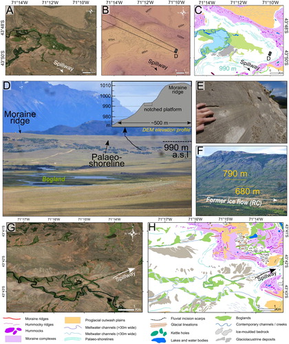
Numerous examples of extensive laminated glaciolacustrine sediment outcrops were found in the Río Corcovado and Río Huemul valleys along road and river cuttings, particularly in areas located on the ice-proximal side of the innermost moraine complexes, at elevations below 790 m (). The glaciolacustrine sediments are characterised by fine, occasionally laminated deposits of clay and silts (cf. CitationEvans, 2014; CitationHenríquez et al., 2017; CitationRabassa et al., 2000; CitationThorndycraft et al., 2019) (e). On imagery, large sediment accumulations can appear as white and grey-coloured assemblages of heavily incised, fragmentary landforms (g). Indeed, soft and unconsolidated glaciolacustrine deposits are more susceptible to post-depositional erosion than coarser till deposits and other proglacial sediment assemblages (e.g. glaciofluvial sands and gravels), especially in the semi-arid Argentine foreland (CitationBendle et al., 2017b; CitationThorndycraft et al., 2019). Such deposits indicate the former presence of substantial proglacial lake bodies following glacier recession. To decrease the potential for misinterpretation, we exclusively mapped glaciolacustrine deposits within flat basins enclosed by conspicuous palaeo-shorelines (c,h).
Figure 7. (A) Satellite imagery (ESRITM, DigitalGlobe), (B) DEM with topographic contour lines (15 m interval) and (C) glacial geomorphological mapping comparisons of a former glaciolacustrine basin in the Río Corcovado valley encircled by well-preserved, highly continuous and parallel palaeo-shorelines (nested between 910 and 990 m) running over tens of kilometres at singular elevations. The former lake basin floor displays a low gradient surface now host to the Río Corcovado as well as an extensive bogland. (D) View towards the northwest (as shown on panel B) of a palaeo-shoreline nested on the ice-distal slope of a terminal moraine ridge in the Río Corcovado valley. This shoreline is associated with the former proglacial lake, which resided in the basin mapped on panel C (camera location: 43°49′43.46″S, 71° 9′54.92″W). An elevation profile graph extrapolated from DEM highlights the geomorphology of the palaeo-shoreline and adjacent moraine ridge. (E) Road cut section through well-preserved laminated varve sediments (location: 43°42′08,0″S, 71°24′41,6″W). (F) View towards the northeast of two continuous palaeo-shorelines cut into the eastern slopes of the Río Corcovado valley (camera location: 43°40′00,5″S, 71°26′26,0″W). (G) Satellite imagery (ESRITM, DigitalGlobe) and (H) glacial geomorphological mapping comparison of another, lower-elevation drained glaciolacustrine basin located in the Río Corcovado valley. This basin displays a high concentration of glaciolacustrine sediment accumulations on its low-gradient basal surface. The hillshade was replaced with a white background on maps C and H to improve visualisation. See for location.
4.4.2. Palaeo-shorelines
Platforms demonstrating a gently curving and convex frontal break of slope nested at single elevations and stretching over extensive distances (sometimes tens of kilometres) were interpreted as former notched proglacial lake shorelines (CitationGlasser & Jansson, 2008; CitationHein et al., 2010; CitationSissons, 1978) (d,f). Such erosional features can be discriminated from continuous moraine ridges through a lack of positive relief, a lower degree of sinuosity, and their occurrence at continuous elevations over great distances. Moreover, lake level fluctuations often lead to several palaeo-shorelines running parallel to each other and to topographic contour lines, which were used additionally to aid feature identification (a,c). Well-preserved examples of palaeo-shorelines can be observed on the windier eastern slopes of the Río Corcovado valley, at elevations of 680 and 790 m (f), as well as towards the terminal environment of the former Río Corcovado glacier, nested between 910 and 990 m in elevation (a,c).
4.4.3. Raised deltas
The mapped region features several fan-shaped, smooth terrace surfaces gently sloping towards valley floors, yet nested distinctively above the valley floors. These deposits are composed of well-sorted, rounded sands and gravels indicating fluvial deposition near the mouths of tributary valleys. After matching the elevations of such features with abandoned palaeo-shorelines, we interpreted these terraces as raised lacustrine deltas formed by tributary rivers flowing into former proglacial lake systems (CitationBendle et al., 2017a, Citation2017b; CitationGlasser et al., 2016). Raised deltas can serve as additional geomorphological evidence of former glaciolacustrine systems and help to identify their former surface elevations. For instance, a well-preserved raised delta can be discerned on the western flank of the Río Corcovado trough, perched on the southern edge of the Río Poncho Moro valley mouth (43°40′5″S; 71°25′4″W). This landform sits at a similar elevation than the prominent 680 m palaeo-shoreline discerned within the valley. Large raised deltas like this specific example can be strong indicators of relatively stable proglacial lake systems (CitationBendle et al., 2017a; CitationHein et al., 2010; CitationTurner et al., 2005).
4.5. Subglacial landforms
4.5.1. Glacial lineations, flutings, drumlinoid forms and ice-moulded bedrock
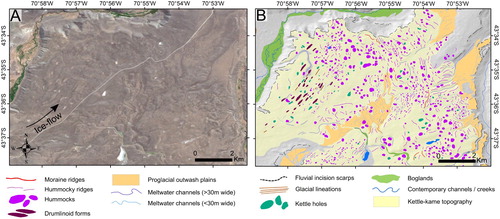
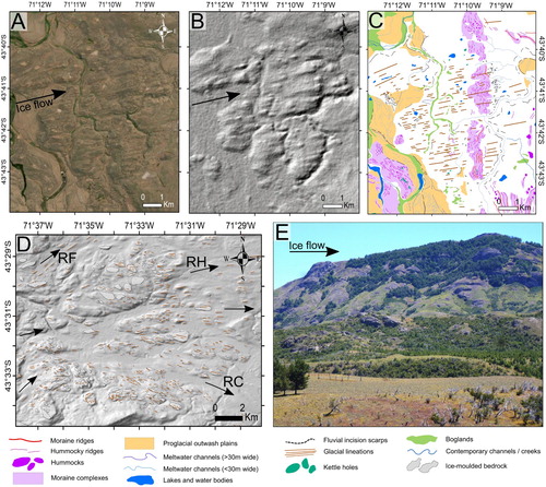
We identified linear, parallel and relatively narrow landforms displaying positive relief with length-to-width ratios of ∼10:1 (). Such features are common in areas of assumed greater former ice-thicknesses, where warm-based, fast-flowing ice could generate either substantial subglacial bedrock erosion, or deposition and/or re-arrangement of glaciogenic sediment along flow lines (CitationBingham et al., 2017; CitationClark et al., 2018; CitationDarvill et al., 2014, Citation2017; CitationSmith et al., 2008). The latter case can lead to the formation of sediment flutes (<10 m in height, a–c). Depositional lineations characterised by oval to ellipsoidal shapes and significant positive relief (>10 m) were interpreted and mapped as drumlinoid forms (CitationKnight, 1997; CitationSpagnolo et al., 2012). In the mapped regions, prominent bedrock outcrops ranging from 20 m to 1 km in width often demonstrate large-scale streamlining (CitationDavies et al., 2020; d,e). Individual outcrops displaying such properties were interpreted and mapped as ice-moulded bedrock. The regional distribution and orientation of subglacial lineations including sediment flutes, drumlinoid features and ice-moulded bedrock outcrops are useful indicators of former ice-flow direction (CitationBentley et al., 2005; CitationBoulton & Clark, 1990). For instance, at our field site, they enable asserting the former convergence of the Río Corcovado and Río Huemul outlets (a–c).
Figure 8. (A) Satellite imagery (ESRITM, DigitalGlobe), (B) DEM hillshade (light azimuth: 315°, incline: 45°) and (C) glacial geomorphological mapping comparisons of the heavily streamlined sediments draped between the eastern Río Corcovado terminal moraine complexes and the Río Huemul valley. These features indicate convergence of the Río Corcovado and Río Huemul outlet glaciers at this location during extensive glaciations. (D) DEM hillshade with glacial lineations and ice-moulded bedrock landforms mapped (with other mapped features removed for visualisation purposes). This bedrock-dominated area presents substantial evidence of subglacial erosion and thus warm-based, fast-flowing ice, and was characterised by the divergence of the PIS into three outlet glaciers: the Río Corcovado glacier to the southeast, the Río Huemul to the east, and the Río Frío (RF) glacier to the northeast. (E) View towards the northwest of ice-moulded bedrock outcrops in the Río Huemul valley (camera location: 43°29′14.16″S, 71°18′23.51″W). See for location.
5. Summary and conclusions
Our map illustrates the sediment-landform assemblages formed by the Quaternary fluctuations of three outlet glaciers in the northeastern sector of the former Patagonian Ice Sheet, the Río Corcovado, Río Huemul and Lago Palena/General Vintter outlet glaciers. This map builds on previous local geological (CitationHaller et al., 2003) and broad-scale glacial geomorphological mapping (CitationCaldenius, 1932; CitationDavies et al., 2020; CitationGlasser & Jansson, 2008) to deliver the first detailed glacial geomorphological map of these valley systems. The mapped landforms incorporate well-established glacial geomorphological features of four major depositional and erosional domains: (1) ice-contact glaciogenic landforms (moraine ridges, hummocks, hummocky ridges, kettle holes, moraine complexes and kettle-kame topography) highlighting the former expansion of outlet glaciers into the Argentine foreland; (2) glaciofluvial landforms (proglacial outwash plains, meltwater channels, fluvial incision scarps, potential glacial lake outburst flood deposits) providing detailed geolocation of former meltwater drainage pathways; (3) glaciolacustrine landforms (palaeo-shorelines, raised deltas and glaciolacustrine deposits) indicating the past formation of ice-dammed proglacial lakes following glacier retreat; and (4) subglacial landforms (ice moulded bedrock, glacial lineations and drumlinoid forms) diagnostic of ice-flow direction and glacier basal conditions.
This map will underpin geomorphological and geochronological investigations aimed at reconstructing the former behaviour of the Río Corcovado, Río Huemul and Lago Palena/General Vintter outlet glaciers during Quaternary glacial cycles. It will also represent an essential geographical dataset for investigations aiming to reconstruct former glaciolacustrine systems as well as major shifts in fluvial drainage pathways during and following local glaciations. Finally, this map provides local empirical boundaries that could be used for high-resolution glacial or ice sheet-scale numerical modelling investigations.
Software
Geomorphological mapping through polyline and polygon shapefile digitisation was conducted using ArcGIS 10.6 software. Final map and figure editing was produced using Adobe Illustrator CC 2020 and Inkscape 0.92.4.
Geolocation information
The study area presented within this map is located between these coordinates:
70°44′0″W – 71°40′0″W; 43°24′0″S – 44°2′0″S
Open Scholarship


This article has earned the Center for Open Science badges for Open Data and Open Materials through Open Practices Disclosure. The data and materials are openly accessible at 10.17632/c2hy8rkbyd.1 and 10.17632/c2hy8rkbyd.1.
Map Shapefiles
The data produced for this map are freely available online, as long as original publication is cited when used and/or referred to. This includes twenty-six shapefiles (.shp) necessary for visualising and analysing the data on a geographical information system such as ArcGIS software. The data are deposited in a Mendeley Data online repository, accessible using this DOI:https://data.mendeley.com/datasets/c2hy8rkbyd/1.
Leger_et_al_final_map.pdf
Download PDF (100.1 MB)Acknowledgments
We wish to express our most sincere gratitude towards all individuals who contributed to the crowdfunding campaign enabling a 2020 field trip to our study site. We also thank the local landowners who authorised access and work on their property, in particular, the Estancia Tecka (Chubut, Argentina) for enabling access to their land and private roads. Moreover, we are grateful to Juan Luis García, Pablo Tapia Gonzalez, Fabian Riquelme and Martin Toro for help in the field and Chiara Van den Hoven for support with figure production and the use of Adobe Illustrator. We thank Professor Neil F. Glasser for sharing shapefiles aiding initial fieldsite determination. Finally, we wish to thank Professor Jasper Knight, Dr. Jacob M. Bendle, Dr. Harold Lovell and Dr. Heike Apps for their reviews and contributions to improve the manuscript and map.
Disclosure statement
No potential conflict of interest was reported by the authors.
Additional information
Funding
References
- Alloway, B. V. , Almond, P. C. , Moreno, P. I. , Sagredo, E. , Kaplan, M. R. , Kubik, P. W. , & Tonkin, P. J. (2018). Mid-latitude trans-Pacific reconstructions and comparisons of coupled glacial/interglacial climate cycles based on soil stratigraphy of cover-beds. Quaternary Science Reviews , 189 , 57–75. https://doi.org/ 10.1016/j.quascirev.2018.04.005
- Bendle, J. M. , Palmer, A. P. , Thorndycraft, V. R. , & Matthews, I. P. (2017B). High-resolution chronology for deglaciation of the Patagonian Ice Sheet at Lago Buenos Aires (46.5 S) revealed through varve chronology and Bayesian age modelling. Quaternary Science Reviews , 177 , 314–339. https://doi.org/ 10.1016/j.quascirev.2017.10.013
- Bendle, J. M. , Thorndycraft, V. R. , & Palmer, A. P. (2017A). The glacial geomorphology of the Lago Buenos Aires and Lago Pueyrredón ice lobes of central Patagonia. Journal of Maps , 13 (2), 654–673. https://doi.org/ 10.1080/17445647.2017.1351908
- Benn, D. I. , & Clapperton, C. M. (2000). Pleistocene glacitectonic landforms and sediments around central Magellan Strait, southernmost Chile: Evidence for fast outlet glaciers with cold-based margins. Quaternary Science Reviews , 19 (6), 591–612. https://doi.org/ 10.1016/S0277-3791(99)00012-8
- Benn, D. I. , & Evans, D. J. (2014). Glaciers and glaciation . Routledge.
- Benn, D. I. , Warren, C. R. , & Mottram, R. H. (2007). Calving processes and the dynamics of calving glaciers. Earth-Science Reviews , 82 (3–4), 143–179. https://doi.org/ 10.1016/j.earscirev.2007.02.002
- Bentley, M. J. , Sugden, D. E. , Hulton, N. R. , & McCulloch, R. D. (2005). The landforms and pattern of deglaciation in the Strait of Magellan and Bahía Inútil, southernmost South America. Geografiska Annaler: Series A, Physical Geography , 87 (2), 313–333. https://doi.org/ 10.1111/j.0435-3676.2005.00261.x
- Bingham, R. G. , Vaughan, D. G. , King, E. C. , Davies, D. , Cornford, S. L. , Smith, A. M. , Arthern, R. J. , Brisbourne, A. M. , De Rydt, J. , Graham, A. G. C. , Spagnolo, M. , Marsh, O. J. , & Shean, D. E. (2017). Diverse landscapes beneath Pine Island Glacier influence ice flow. Nature Communications , 8 (1), 1–9. https://doi.org/ 10.1038/s41467-017-01597-y
- Blair, T. C. (2002). Alluvial-fan sedimentation from a glacial-outburst flood, Lone Pine, California, and contrasts with meteorological flood deposits. Flood and Megaflood Processes and Deposits: Recent and Ancient Examples , 111–140. https://doi.org/ 10.1002/9781444304299.ch8
- Boulton, G. S. , & Clark, C. D. (1990). The Laurentide ice sheet through the last glacial cycle: The topology of drift lineations as a key to the dynamic behaviour of former ice sheets. Transactions of the Royal Society of Edinburgh: Earth Sciences , 81 (4), 327–347. https://doi.org/ 10.1017/S0263593300020836
- Caldenius, C. C. Z. (1932). Las glaciaciones cuaternarias en la patagonia y tierra del fuego. Geografiska Annaler , 14 , 1–164. https://doi.org/ 10.1080/20014422.1932.11880545
- Chandler, B. M. , Lovell, H. , Boston, C. M. , Lukas, S. , Barr, I. D. , Benediktsson, Í. Ö. , Benn, D. I. , Clark, C. D. , Darvill, C. M. , Evans, D. J. , & Ewertowski, M. W. (2018). Glacial geomorphological mapping: A review of approaches and frameworks for best practice. Earth-Science Reviews , 185 , 806–846. https://doi.org/ 10.1016/j.earscirev.2018.07.015
- Clapperton, C. M. (1993). Quaternary geology and geomorphology of South America (Vol. 25). Elsevier.
- Clapperton, C. M. , Sugden, D. E. , Kaufman, D. S. , & McCulloch, R. D. (1995). The last glaciation in central Magellan Strait, southernmost Chile. Quaternary Research , 44 (2), 133–148. https://doi.org/ 10.1006/qres.1995.1058
- Clark, C. D. , Ely, J. C. , Greenwood, S. L. , Hughes, A. L. , Meehan, R. , Barr, I. D. , Bateman, M. D. , Bradwell, T. , Doole, J. , Evans, D. J. , & Jordan, C. J. (2018). BRITICE glacial Map, version 2: A map and GIS database of glacial landforms of the last British–Irish Ice Sheet. Boreas , 47 (1), 11–e8. https://doi.org/ 10.1111/bor.12273
- Coronato, A. , Ercolano, B. , Corbella, H. , & Tiberi, P. (2013). Glacial, fluvial and volcanic landscape evolution in the Laguna Potrok Aike maar area, Southern Patagonia, Argentina. Quaternary Science Reviews , 71 , 13–26. https://doi.org/ 10.1016/j.quascirev.2012.06.019
- Darvill, C. M. , Bentley, M. J. , Stokes, C. R. , Hein, A. S. , & Rodés, Á . (2015). Extensive MIS 3 glaciation in southernmost Patagonia revealed by cosmogenic nuclide dating of outwash sediments. Earth and Planetary Science Letters , 429 , 157–169. https://doi.org/ 10.1016/j.epsl.2015.07.030
- Darvill, C. M. , Bentley, M. J. , Stokes, C. R. , & Shulmeister, J. (2016). The timing and cause of glacial advances in the southern mid-latitudes during the last glacial cycle based on a synthesis of exposure ages from Patagonia and New Zealand. Quaternary Science Reviews , 129 , 200–214. https://doi.org/10.1016/j.quascirev.2016.07.024 10.1016/j.epsl.2015.07.030
- Darvill, C. M. , Stokes, C. R. , Bentley, M. J. , Evans, D. J. , & Lovell, H. (2017). Dynamics of former ice lobes of the southernmost Patagonian Ice Sheet based on a glacial landsystems approach. Journal of Quaternary Science , 32 (6), 857–876. https://doi.org/ 10.1002/jqs.2890
- Darvill, C. M. , Stokes, C. R. , Bentley, M. J. , & Lovell, H. (2014). A glacial geomorphological map of the southernmost ice lobes of Patagonia: the Bahía Inútil–San Sebastián, Magellan, Otway, Skyring and Río Gallegos lobes. Journal of Maps , 10 (3), 500–520. https://doi.org/ 10.1080/17445647.2014.890134
- Davies, B. J. , Darvill, C. M. , Lovell, H. , Bendle, J. M. , Dowdeswell, J. A. , Fabel, D. , Garcia, J.-L. , Geiger, A. , Glasser, N. F. , Gheorghiu, D. M. , Harrison, S. , Hein, A. S. , Kaplan, M. R. , Martin, J. R. V. , Mendelova, M. , Palmer, A. , Pelto, M. , Rodes, A. , Sagredo, E. A. , … Thorndycraft, V. R. (2020). The evolution of the Patagonian Ice Sheet from 35 ka to the Present Day (PATICE). Earth-Science Reviews , 204 , 103152. https://doi.org/ 10.1016/j.earscirev.2020.103152
- Davies, B. J. , Thorndycraft, V. R. , Fabel, D. , & Martin, J. R. V. (2018). Asynchronous glacier dynamics during the Antarctic Cold Reversal in central Patagonia. Quaternary Science Reviews , 200 , 287–312. https://doi.org/ 10.1016/j.quascirev.2018.09.025
- Denton, G. H. , Lowell, T. V. , Heusser, C. J. , Schlüchter, C. , Andersen, B. G. , Heusser, L. E. , Moreno, P. I. , & Marchant, D. R. (1999). Geomorphology, stratigraphy, and radiocarbon chronology of Llanquihue Drift in the area of the Southern Lake District, Seno Reloncaví, and Isla Grande de Chiloé, Chile. Geografiska Annaler, Series A: Physical Geography , 81 (2), 167–229. https://doi.org/ 10.1111/j.0435-3676.1999.00057.x
- Dunai, T. J. (2010). Cosmogenic Nuclides: Principles, concepts and applications in the Earth surface sciences . Cambridge University Press.
- Evans, D. J. A. (2014). Glacial landsystems . Routledge.
- Evans, D. J. A. , & Orton, C. (2015). Heinabergsjökull and Skalafellsjökull, Iceland: Active temperate piedmont lobe and outwash head glacial landsystem. Journal of Maps , 11 (3), 415–431. https://doi.org/ 10.1080/17445647.2014.919617
- Eyles, N. , Boyce, J. I. , & Barendregt, R. W. (1999). Hummocky moraine: Sedimentary record of stagnant Laurentide Ice Sheet lobes resting on soft beds. Sedimentary Geology , 123 (3–4), 163–174. https://doi.org/ 10.1016/S0037-0738(98)00129-8
- García, J. L. , Hein, A. S. , Binnie, S. A. , Gómez, G. A. , González, M. A. , & Dunai, T. J. (2018). The MIS 3 maximum of the Torres del Paine and Última Esperanza ice lobes in Patagonia and the pacing of southern mountain glaciation. Quaternary Science Reviews , 185 , 9–26. https://doi.org/ 10.1016/j.quascirev.2018.01.013
- García, J. L. , Maldonado, A. , de Porras, M. E. , Delaunay, A. N. , Reyes, O. , Ebensperger, C. A. , Binnie, S. A. , Lüthgens, C. , & Méndez, C. (2019). Early deglaciation and paleolake history of Río Cisnes glacier, Patagonian ice sheet (44° S). Quaternary Research , 91 (1), 194–217. https://doi.org/ 10.1017/qua.2018.93
- Garreaud, R. , Lopez, P. , Minvielle, M. , & Rojas, M. (2013). Large-scale control on the Patagonian climate. Journal of Climate , 26 (1), 215–230. https://doi.org/ 10.1175/JCLI-D-12-00001.1
- Glasser, N. , & Jansson, K. (2008). The glacial map of southern South America. Journal of Maps , 4 (1), 175–196. https://doi.org/ 10.4113/jom.2008.1020
- Glasser, N. F. , Jansson, K. N. , Duller, G. A. , Singarayer, J. , Holloway, M. , & Harrison, S. (2016). Glacial lake drainage in Patagonia (13-8 kyr) and response of the adjacent Pacific Ocean. Scientific Reports , 6 (1), 21064. https://doi.org/ 10.1038/srep21064
- Glasser, N. F. , Jansson, K. N. , Harrison, S. , & Kleman, J. (2008). The glacial geomorphology and Pleistocene history of South America between 38°S and 56°S. Quaternary Science Reviews , 27 (3–4), 365–390. https://doi.org/ 10.1016/j.quascirev.2007.11.011
- Haller, M. , Lech, R. R. , Martinez, O. A. , Meister, C. M. , & Page, S. M. (2003). Hoja Geologica 4373IV/III, Trevelin, Provincia del Chubut. Programa Nacional de Cartas Geologicas de la Republica Argentina, 1:250.000 . Servicio Geologico Nacional.
- Hein, A. S. , Cogez, A. , Darvill, C. M. , Mendelova, M. , Kaplan, M. R. , Herman, F. , Dunai, T. J. , Norton, K. , Xu, S. , Christl, M. , & Rodés, Á . (2017). Regional mid-Pleistocene glaciation in central Patagonia. Quaternary Science Reviews , 164 , 77–94. https://doi.org/ 10.1016/j.quascirev.2017.03.023
- Hein, A. S. , Dunai, T. J. , Hulton, N. R. , & Xu, S. (2011). Exposure dating outwash gravels to determine the age of the greatest Patagonian glaciations. Geology , 39 (2), 103–106. https://doi.org/ 10.1130/G31215.1
- Hein, A. S. , Hulton, N. R. , Dunai, T. J. , Schnabel, C. , Kaplan, M. R. , Naylor, M. , & Xu, S. (2009). Middle Pleistocene glaciation in Patagonia dated by cosmogenic-nuclide measurements on outwash gravels. Earth and Planetary Science Letters , 286 (1–2), 184–197. https://doi.org/ 10.1016/j.epsl.2009.06.026
- Hein, A. S. , Hulton, N. R. , Dunai, T. J. , Sugden, D. E. , Kaplan, M. R. , & Xu, S. (2010). The chronology of the Last Glacial Maximum and deglacial events in central Argentine Patagonia. Quaternary Science Reviews , 29 (9–10), 1212–1227. https://doi.org/ 10.1016/j.quascirev.2010.01.020
- Henríquez, W. I. , Villa-Martínez, R. , Vilanova, I. , Pol-Holz, R. D. , & Moreno, P. I. (2017). The Last Glacial Termination on the eastern flank of the central Patagonian Andes (47°S). Climate of the Past , 13 (7), 879–895. https://doi.org/ 10.5194/cp-13-879-2017
- Hubbard, A. , Hein, A. S. , Kaplan, M. R. , Hulton, N. R. , & Glasser, N. (2005). A modelling reconstruction of the last glacial maximum ice sheet and its deglaciation in the vicinity of the Northern Patagonian Icefield, South America. Geografiska Annaler: Series A, Physical Geography , 87 (2), 375–391. https://doi.org/ 10.1111/j.0435-3676.2005.00264.x
- Iglesias, V. , Markgraf, V. , & Whitlock, C. (2016). 17,000 years of vegetation, fire and climate change in the eastern foothills of the Andes (lat. 44 S). Palaeogeography, Palaeoclimatology, Palaeoecology , 457 , 195–208. https://doi.org/ 10.1016/j.palaeo.2016.06.008
- Kaplan, M. R. , Hein, A. S. , Hubbard, A. , & Lax, S. M. (2009). Can glacial erosion limit the extent of glaciation? Geomorphology , 103 (2), 172–179. https://doi.org/ 10.1016/j.geomorph.2008.04.020
- Knight, J. (1997). Morphological and morphometric analyses of drumlin bedforms in the Omagh Basin, north central Ireland. Geografiska Annaler: Series A, Physical Geography , 79 (4), 255–266. https://doi.org/ 10.1111/j.0435-3676.1997.00021.x
- Knight, J. (2011). Uses and limitations of field mapping of lowland glaciated landscapes. Developments in Earth Surface Processes , 15 , 533–550. https://doi.org/ 10.1016/B978-0-444-53446-0.00021-5
- Lambeck, K. , Rouby, H. , Purcell, A. , Sun, Y. , & Sambridge, M. (2014). Sea level and global ice volumes from the Last Glacial Maximum to the Holocene. Proceedings of the National Academy of Sciences , 111 (43), 15296–15303. https://doi.org/ 10.1073/pnas.1411762111
- Lapido, O. (1990). Glacial deposits on the Patagonian Cordillera at latitude 43°30′ south. Quaternary of South America and Antarctic Peninsula , 6 , 257–266.
- Martin, J. R. , Davies, B. J. , & Thorndycraft, V. R. (2019). Glacier dynamics during a phase of Late Quaternary warming in Patagonia reconstructed from sediment landform associations. Geomorphology , 337 , 111–133. https://doi.org/ 10.1016/j.geomorph.2019.03.007
- Martínez, O. (2002). Geomorfología y geología de los depositós glaciarios y periglaciarios de la región comprendida entre los 43° y 44° lat. Sur y 70°30′ y 72° long. Oeste, Chubut, República Argentina [Unpublished doctoral thesis]. Universidad Nacional de la Patagonia-San Juan Bosco, Comodoro Rivadavia and Esquel.
- Martínez, O. , Coronato, A. , & Rabassa, J. (2011). Pleistocene glaciations in northern Patagonia, Argentina: An updated review. Developments in Quaternary Sciences , 15 , 729–734. https://doi.org/ 10.1016/B978-0-444-53447-7.00052-0
- Mendelová, M. , Hein, A. S. , McCulloch, R. , & Davies, B. (2017). The Last Glacial Maximum and deglaciation in central Patagonia, 44° S–49° S. Cuadernos de Investigación Geográfica , 43 (2), 719–750. https://doi.org/ 10.18172/cig.3263
- Mendelová, M. , Hein, A. S. , Rodés, Á , & Xu, S. (2020). Extensive mountain glaciation in central Patagonia during Marine Isotope Stage 5. Quaternary Science Reviews , 227 , 105996. https://doi.org/ 10.1016/j.quascirev.2019.105996
- Moreiras, S. M. , Páez, M. S. , Lauro, C. , & Jeanneret, P. (2017). First cosmogenic ages for glacial deposits from the Plata range (33°S): New inferences for Quaternary landscape evolution in the Central Andes. Quaternary International , 438 , 50–64. https://doi.org/ 10.1016/j.quaint.2016.08.041
- Olszak, J. (2011). Evolution of fluvial terraces in response to climate change and tectonic uplift during the Pleistocene: Evidence from Kamienica and Ochotnica River valleys (Polish Outer Carpathians). Geomorphology , 129 (1–2), 71–78. https://doi.org/ 10.1016/j.geomorph.2011.01.014
- Price, R. J. (1969). Moraines, sandar, kames and eskers near Breidamerkurjökull, Iceland. Transactions of the Institute of British Geographers , 17–43. https://doi.org/ 10.2307/621406
- Rabassa, J. , Coronato, A. , Bujalesky, G. , Salemme, M. , Roig, C. , Meglioli, A. , Heusser, C. , Gordillo, S. , Roig, F. , Borromei, A. , & Quattrocchio, M. (2000). Quaternary of Tierra del Fuego, southernmost South America: An updated review. Quaternary International , 68 , 217–240. https://doi.org/ 10.5027/andgeoV5n1-a01 doi: 10.1016/S1040-6182(00)00046-X
- Raedeke, L. D. (1978). Formas del terreno y depósitos cuaternarios, Tierra del Fuego Central, Chile. Revista geológica de Chile: An International Journal on Andean Geology , 5 , 3–31. https://doi.org/ 10.1016/S1040-6182(00)00046-X
- Russell, A. J. , Roberts, M. J. , Fay, H. , Marren, P. M. , Cassidy, N. J. , Tweed, F. S. , & Harris, T. (2006). Icelandic jökulhlaup impacts: Implications for ice-sheet hydrology, sediment transfer and geomorphology. Geomorphology , 75 (1–2), 33–64. https://doi.org/ 10.1016/j.geomorph.2005.05.018
- Sagredo, E. A. , Moreno, P. I. , Villa-Martínez, R. , Kaplan, M. R. , Kubik, P. W. , & Stern, C. R. (2011). Fluctuations of the Última Esperanza ice lobe (52°S), Chilean Patagonia, during the last glacial maximum and termination 1. Geomorphology , 125 (1), 92–108. https://doi.org/ 10.1016/j.geomorph.2010.09.007
- Sissons, J. B. (1978). The parallel roads of Glen Roy and adjacent glens, Scotland. Boreas , 7 (4), 229–244. https://doi.org/ 10.1111/j.1502-3885.1978.tb00281.x
- Smedley, R. K. , Glasser, N. F. , & Duller, G. A. T. (2016). Luminescence dating of glacial advances at Lago Buenos Aires (∼ 46°S), Patagonia. Quaternary Science Reviews , 134 , 59–73. https://doi.org/ 10.1016/j.quascirev.2015.12.010
- Smith, M. J. , Knight, J. , Field, K. S. , & Harrison, S. (2008). Glacial striae observations for Ireland compiled from historic records. Journal of Maps , 4 (1), 378–398. https://doi.org/ 10.4113/jom.2008.1035
- Soteres, R. L. , Peltier, C. , Kaplan, M. R. , & Sagredo, E. A. (2020). Glacial geomorphology of the Strait of Magellan ice lobe, southernmost Patagonia, South America. Journal of Maps , 16 (2), 299–312. https://doi.org/ 10.1080/17445647.2020.1736197
- Spagnolo, M. , Clark, C. D. , & Hughes, A. L. (2012). Drumlin relief. Geomorphology , 153 – 154 , 179–191. https://doi.org/ 10.1016/j.geomorph.2012.02.023
- Tarolli, P. , & Mudd, S. M. (2019). Remote sensing of geomorphology (Vol. 23). Elsevier.
- Thorndycraft, V. R. , Bendle, J. M. , Benito, G. , Davies, B. J. , Sancho, C. , Palmer, A. P. , Fabel, D. , Medialdea, A. , & Martin, J. R. (2019). Glacial lake evolution and Atlantic-Pacific drainage reversals during deglaciation of the Patagonian Ice Sheet. Quaternary Science Reviews , 203 , 102–127. https://doi.org/ 10.1016/j.quascirev.2018.10.036
- Turner, K. J. , Fogwill, C. J. , McCulloch, R. D. , & Sugden, D. E. (2005). Deglaciation of the eastern flank of the North Patagonian Icefield and associated continental-scale lake diversions. Geografiska Annaler: Series A, Physical Geography , 87 (2), 363–374. https://doi.org/ 10.1111/j.0435-3676.2005.00263.x
- Van Daele, M. , Bertrand, S. , Meyer, I. , Moernaut, J. , Vandoorne, W. , Siani, G. , Tanghe, N. , Ghazoui, Z. , Pino, M. , Urrutia, R. , & De Batist, M. (2016). Late Quaternary evolution of Lago Castor (Chile, 45.6 S): Timing of the deglaciation in northern Patagonia and evolution of the southern westerlies during the last 17 kyr. Quaternary Science Reviews , 133 , 130–146. doi: 10.1016/j.quascirev.2015.12.021