
ABSTRACT
Rimini is located at the southernmost end of the Po Plain, in Emilia-Romagna region. The geomorphology of the site mainly depends on the actions of the Marecchia River, coupled with marine processes in Holocene times. By creating a geomorphological map of the area, we highlight the factors that influenced the historical evolution of the town, relating them to anthropic features, with acmes in natural changes probably matching periods of climate deterioration. Many clues suggest that the Marecchia river pattern changed frequently and drastically during the climate deterioration of the Early Middle Ages, when the river’s name changed from Ariminus to Maricula (‘little sea’). The river frequently aggraded and overflowed during the climate deterioration of the Little Ice Age and until the early twentieth century. The urban geomorphological map, implemented according to the official ISPRA cartography criteria, has enabled us to highlight valuable elements for reconstructing the evolution of the town, that are now almost completely hidden by urbanisation.
1. Introduction
It is significant that before the industrial era human settlements were conditioned by the geomorphological characteristics of the territory and its geological resources (CitationDel Monte et al., 2016 and references therein), and in ancient urban planning great attention to geological risks was given. Subsequently, after the second half of 1900, the massive human presence strongly influenced the evolution of the urban landscape (CitationBrandolini, 2017). Soil degradation, waterway regulation and expansion of industrial, commercial and housing areas have inevitably affected the landscape surrounding the ancient settlements, destroying the previous morphologies and greatly complicating the work of reconstruction of the landscape (CitationLongares Aladrén et al., 2013). This trend has been detected in many Mediterranean urban areas (CitationBrandolini et al., 2019; CitationReynard et al., 2017), especially the coastal ones which are the most sensitive, not only because they are the main areas of migration from the hinterland, but also because they are transition environments and therefore very responsive to climatic changes (CitationBrandolini et al., 2017, Citation2018). The Adriatic coast hosts many important ancient settlements dating back to the Roman Age and later times, in an area highly sensitive to Pleistocene-Holocene climatic changes (CitationNesci et al., 2012), especially in relation to river mouths deviations and, secondly, coastline variations (CitationDall’Aglio et al., 2017; CitationDe Donatis et al., 2019).
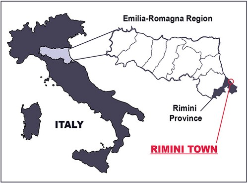
The study area is located in the Emilia-Romagna region, along the Adriatic Sea coastline, at the Marecchia River’s mouth (). The town of Rimini rests on Marecchia and Ausa alluvial sediments; the site’s geography and geomorphology mainly depend on fluvial dynamics and, secondly, on marine processes. Rimini, from the Latin Ariminum, was chosen as a settlement area because of environmental factors such as access to the Adriatic Sea and an abundance of water springs. Climate variations in historical times have played a significant role in shaping the town’s environment: the Marecchia River has been known for its torrential temper since ancient times (CitationSerpieri, 2004), causing floods, cut-offs and hydraulic instability.
Figure 1. Rimini town location map.
In order to produce a comprehensive portrait of the geomorphological evolution of urban settlements in the Mediterranean basin, we report the most significant climatic events from the Roman age to the present day (CitationDeline & Orombelli, 2005; CitationHolzhauser et al., 2005; CitationOrombelli, 2007; CitationOrtolani & Pagliuca, 2007; CitationRoveri et al., 2001), hereinafter referred to as acronyms in this paper: Roman climate optimum (R-CO), c. 100–300 AD; Early Middle Ages climate deterioration (EMA-CD), c. 500–750 AD; Middle Ages climate optimum (MA-CO), c. 1000–1300 AD; Little ice age - LIA, c. 1500–1850 AD.
River depositional processes are favoured by cold climatic events (CitationNesci et al., 2012), while erosive ones are related to warm periods. In the area of study, the landforms (e.g. river mouths progradation, beach advancement) are well defined only for the most recent periods because correlated with geoarchaeological and local topographic data. For ancient events only a stratigraphic interpretation of the alluvial deposits is possible, which, combined with geomorphological analyses, enables a possible archaeo-environmental interpretation of the area.
2. Aim of the map
Several issues must be taken into account when studying Rimini’s geomorphological evolution. The town is situated in a complex location, in which multiple natural processes and agents interact, with examples being littoral and fluvial dynamics, subsidence and sea-level variations (CitationCremonini, 1995). Anthropic modifications have also played a significant role, with interventions like fluvial diversions, underground aqueducts and the restoration of swampy areas dating back to Roman times (III century BC to III century AD) (CitationRavara Montebelli, 2002). This study tries to relate geological and geomorphological analyses with historical records, toponyms, and ancient cartographies. The goal is to highlight the relationship between human activity and geological and geomorphological context in order to understand what has been the most influential geomorphological agent in environmental changes.
Given its characteristics, Rimini could also be studied as an example of an urban complex geomorphosite, with actions undertaken to promote its geomorphological heritage. The co-existence of natural and anthropic processes, which have been active in Rimini for at least 2000 years, has produced a unique geomorphological and human landscape that is currently mostly hidden or irrecoverable. A geomorphological reading of the urban fabric would be extremely interesting for tourists and citizens, and could complement classical urban visits that generally focus on cultural heritage (CitationReynard et al., 2017).
3. Study area
3.1. Historical background
The first traces of human presence in the area can be set at 800,000 years BP, with Palaeolithic tools and testimonies found in the Covignano hills (CitationFontemaggi & Piolanti, 1995), 2 km inland. The Villanovian people - early stages of the Etruscan culture – thrived in what is now Verucchio (c. 18 km inland following the Marecchia River) from the X to the VII century BC, and Etruscan testimonies can be found on the Covignano hills from the VI century BC. Stable settlements in the littoral area by a heterogeneous population composed of Umbrians, Etruscans and Celts are thought to be from at least the IV century BC (CitationOrtalli, 2000).
Rimini became a Roman colony in 268 BC. This resulted in a major demographic increase, with the town and its surrounding countryside undergoing a huge reorganization (CitationFontemaggi & Piolanti, 1995): Via Flaminia (220 BC), Via Aemilia (187 BC) and Via Popilia (132 BC) were built, the territories from the Cesena plains to the River Conca valley (south of Rimini) were reclaimed from the swamps, and the Roman centuriation grid covered these lands almost entirely (CitationOrtalli, 2000).
3.2. Geographical, geological and geomorphological settings
The town of Rimini lies on the top of fluvial, transitional and marine deposits, in a morphodynamic context where the interaction among several morphogenetic processes (CitationCremonini, 1995), both natural and anthropic (ancient and recent), prevents from establishing a precise chronology for the various development phases of the city in relation to the underlying natural processes. The city centre, for instance, is slightly elevated, as the result of pre-existing morphologies and human interventions, like swamp reclamation works that can be dated back to roman times (CitationZaghini, 2000).
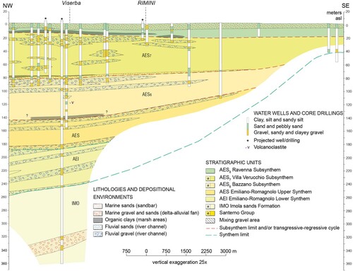
The geological base-map used in this study derives from the CARG project’s database (Rimini sheet, n. 256). The mapped deposits belong to the Emilia-Romagna Superior Synthem (AES), Ravenna Subsynthem (AES8), and Modena Unit (AES8a) (CitationAA.VV., 2005). Most parts of the study area lie on packed layers of sand, silt and clay from river overflows (AES8). The longshore bars and deposits that comprise the coastal area (above and below sea level) belong to the Modena Unit (AES8a). The cuspidate morphology of littoral sands (enhanced by the build-up of sediments SE of the harbour), gravel barrier islands and sandbar deposits suggest a delta-front origin. Sandbars can be found 1–2.5 km from the shoreline and can reach – 6 to – 9 m in depth. They gradually move towards the prodelta and transition to shelf silt and clays, up to a maximum depth of −17 m. In the off-shore sector, shallow deposits belong to the Modena Unit, the base limit of which can be identified as a facies change from prevailing silt to sandy silt and silty sand. The unit has an average thickness of 3–4 m. Abundant Roman and previous archaeological findings in relation to the sediments beneath AES8a, their complete absence inside the unit (except for reworked fragments), and the limited or absent pedogenesis suggest a post-Roman age, which was purportedly deposited between the IV and VI centuries AD (CitationVeggiani, 1986, Citation1988a) to today. In the floodplain area, the main morphogenetic agents are the outflows from rivers Uso, Marecchia and Ausa starting from the north. The main alluvial fan is the Marecchia one, with a volume of c. 94 km3 (40% below sea level) and a maximum thickness of about 300 m. It develops from Ponte Verucchio, where the top of the depositional surface is about 100 m asl, down to the mouth of the river, where the top of the depositional surface drops to 5 m asl (CitationSeveri & Zaghini, 1996) ().
Figure 2. Marecchia River alluvial fan. Geological section from https://applicazioni.regione.emilia-romagna.it/cartografia_sgss/user/viewer.jsp?service=sezioni_geo, modified.
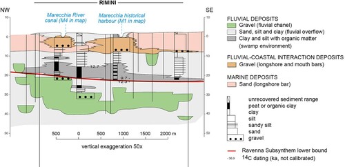
The Ravenna Subsynthem and Modena Unit can be considered intra-valley bottom plains, with a wide later continuity of the deposition. Where clay units outcrop, stream terraces are generally barely preserved, but where sands and gravels prevail a better conservation of the landforms and terraces is possible. The Modena Unit includes the most recent and shallow deposits in the study area. In the intra-valley sectors, this is composed of stream terrace deposits, while there are gravel, sand and silt layers that lay on top of one another in the alluvial plain, creating an intricate pattern that merges towards the sea. The deposits with prevalent gravel lie closer to the main riverbed positions and represent the continuative prosecution of the gravel terrace deposits. An elongated gravel deposit lies at the bottom of the Marecchia River valley, extending to the coastline and reaching a maximum width of 1.5 km. Fluvial overflow deposits are found sideways to the gravel deposits and are composed of sand and silt sediment (riverbanks and river and cut-off channels), and silt and clay sediment (floodplain) ().
Figure 3. Closeup of Rimini. Geological section from https://applicazioni.regione.emilia-romagna.it/cartografia_sgss/user/viewer.jsp?service=sezioni_geo, modified.
The prevailing fluvial morphologies in the lower portion of the Marecchia fan are: stream terraces with erosive cliffs (abandoned or active); and erosive processes inside the riverbed, which are strictly connected to excavations of gravel and sand to obtain construction materials for the urban expansion of Rimini after 1950. This factor, combined with the building of dams and weirs, led to a significant decrease in the solid load and triggered upstream aggradation and downstream erosive processes (CitationPreti et al., 2008).
A peculiar landform in Rimini’s coastal area is a sub-vertical erosive cliff, which is a wave-cut scarp associated with an ancient coastline that overcrops from Viserbella to Viserba, Torre Pedrera to Bellaria (north of the study area, with a maximum height of 6 m) and Riccione to Cattolica (south of the study area, with a maximum height of 10 m). Various authors have assigned different dates to the wave-cut scarp, that span from the post-glacial Optimum to c. 1000 years BP (CitationColtorti, 1991; CitationElmi et al., 1994; CitationElmi et al., 2002; CitationParea, 1986; CitationSeveri & Zaghini, 1996; CitationVeggiani, 1988b). Littoral sands and gravel deposits lie at the foot of the slope, forming a morphologically flat (0–2 m asl) coastal plain south of Rimini harbour that originated from fluvial and coastal dynamics combined with anthropic modifications. Before 1950, sandbars of recent formation (c. 1820 according to CitationAntoniazzi, 1972) ran along the shoreline and reached 3–4 m above sea level (CitationZaghini, 2000).
4. Methodology
Many studies have examined Rimini’s geology and geomorphology. However, to date, it has been particularly hard to investigate historical changes in landforms and natural dynamics, because of the widespread urbanization of its surrounding areas, mostly after 1950, which erased or covered natural landforms and deposits (CitationDall’Aglio et al., 2017). In modelling the present map, considerations from CitationZaghini, 2000; CitationVeggiani, 1983; Citation1986; Citation1988a; Citation1988b; Citation1991; CitationAntoniazzi, 1972; Citation1976; Citation1996; CitationZaghini, 1991; Citation1993; Citation1994; Citation1995 were taken into account with respect to the study area, and CitationElmi et al., 1994, Citation2002; CitationGuerra, 2012; CitationElmi et al., 1991 for the wider geomorphological framework.
Geotechnical corings and water-well drillings, which were spatially referenced and available in the webGIS of SGSS catalogue of the Emilia-Romagna region were consulted in a search for alluvial deposits that could be attributed to the Marecchia River diversions in historical times. Shallow gravel deposits (< 10 m) have therefore been highlighted on the map as an indication of a more- or less-stable river path in that position.
This information was then overlapped with the LiDAR (light detection and ranging) altimetry reading survey conducted by the Emilia-Romagna region in 2010. This particular source enabled us to identify some of the presumed river mouths fairly accurately (see Map, image 2).
Historical aerial pictures (see ) were consulted to try to pinpoint landforms that are now hidden by urbanization; the wave-cut scarp that cannot be seen close to Rimini’s town centre, because of recent sedimentary cover deposits from the Marecchia and Ausa rivers and subsequent urbanization, has been identified in the town’s southern portion as a light line visible in the pictures.
Table 1. Historical ortophotos, maps and cadastres consulted.
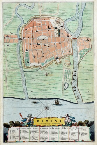
Historical views of the city and cadastres (see ) have been taken into account, especially when assuming the Marecchia River’s meandering behaviour during climate deterioration periods. Significant variations in the riverbed’s position can be observed when comparing different spatially referenced cadastres, especially close to the town centre, where the river flew until 1930s, in the area of today’s XXV Aprile park (see Map, image 1).
The geological and geomorphological research was then compared with historical records, archaeological studies and toponyms.
5. Results and discussion
The geomorphological and historic evolution of Rimini town and its surroundings is quite similar to that of some other Italian coastal cities (CitationDall’Aglio et al., 2017; CitationDe Donatis et al., 2019; CitationDel Monte et al., 2016). The processes of the Upper Holocene are certainly the result of climatic deterioration but are also related to human intervention (CitationBuckner, 1986; CitationVita-Finzi, 1969). In particular, some geoarchaeological data highlighted in the present work well correspond with global environmental events (CitationOrombelli, 2007; CitationHolzhauser et al., 2005): the EMA-CD relates with 1.4 Bond event, and it has been climatically defined in (CitationBüntgen et al., 2016; CitationHelama et al., 2017; CitationPeña Monné et al., 2018).
The site of some still-standing Roman monuments in Rimini’s centre is valuable for reconstructing the geomorphological evolution of the town in historical times:
Augustus Arch (27 BC), at the end of Via Flaminia, one of the main entrances to the Roman colony (n. 1 in Map);
Ausa bridge (I century BC) crossed the Ausa stream in front of the Augustus Arch until the XX century (CitationCesaretti, 2004) (n. 2 in Map);
Patara bridge (I century BC) lies hidden under Rimini’s streets, crossing a natural stream known as Patara ditch that ran through the town centre (CitationRavara Montebelli, 2002) (n. 3 in Map);
Tiberius bridge (21 AD) attests the position of the Marecchia riverbed at that time (n. 4 in Map);
Amphitheatre (21 AD, n. 5 in Map) and the Surgeon’s Domus (II century AD, n. 6 in Map) were historically said to be built on a wave-cut scarp that some authors have dated back to the R-CO (CitationColtorti, 1991; CitationElmi et al., 1994; CitationElmi et al., 2002).
Two underground aqueducts can be referred to Roman times (CitationRavara Montebelli, 2002): the first enters the town close to Castel Sismondo (Roman spring in Map) and the second brings water from Mt. Cavo (= hollow) to Patara ditch (Mt. Cavo spring in Map).
Some records suggest that many changes took place in Rimini’s landscape as early as the III-IV centuries AD. Indeed, there was a major climatic deterioration during the period from the Late Antiquity (LA) to the Early Middle Ages (EMA) (CitationHolzhauser et al., 2005; CitationOrombelli, 2007): most of the Roman centuriation grid was lost because of fluvial diversions and the land became swampy and unhealthy, contributing to the development of famine and disease (CitationVeggiani, 1988a). Via Popilia, which ran through Rimini and the ancient Po River delta that followed longshore bars was abandoned in favour of an inland path, probably because of generalized hydrogeological instability (CitationDall’Aglio, 2000). Via Aemilia was forced to abandon its linear path in the LA and turned in front of St. Giuliano church (CitationOrtalli, 2010). In the town centre, the area between Patara ditch and Augustus Arch, was in a lower position than its surroundings, requiring work to reclaim the land in Augustus times (CitationOrtalli, 2010); it was then deserted from the IV century onwards (CitationOrtalli, 1995). Furthermore, the site that came to host Castel Sismondo and St. Colomba Cathedral suffered from marginalization in the LA (CitationOrtalli, 2010).
Such testimonies can be correlated with stratigraphic geological surveys conducted inside the Roman walls in the last decades, that appear to confirm Marecchia fluvial diversions in the area that is now Cavour Square, with anthropic layers overtopped by flood sedimentary facies.
The behaviour of the Ausa River resembled that of the Marecchia River on a much smaller scale, and traces of fluvial diversions can be found by analyzing some of the toponyms related to this. Prior to the Middle Ages, both the Ausa River and Patara ditch were called Apsa, Avusa, Apusa, and Apsella, which were generic terms for stream. Some toponyms, such as Apisa interiore (= interior), related to Patara ditch, and Apsa magna, to the Ausa River (CitationDelucca, 2000), could be interpreted as a tendency of the river to flood in the direction of the ditch, with a possible merging of the two river paths during climate deterioration periods. Unfortunately, geological surveys are absent in this city area and cannot confirm or rule out the historical and archaeological interpretations.
The R-CO could represent more stable alluvial and littoral dynamics, with partial erosion and the redistribution of previously deposited sediments. Some authors (CitationColtorti, 1991; CitationElmi et al., 1994, Citation2002) relate the wave-cut scarp to the R-CO, but the dating is still unclear. Certain evidence suggests that the scarp has been active (or at least re-activated) in post-Roman times (CitationSeveri & Zaghini, 1996).
The climatic conditions changed drastically between the V and VIII centuries: temperatures fell and rainfall rose, causing increased solid load, riverbed raising, and flooding. This led to the abandonment of manmade buildings and structures that had originated close to the river banks in the Roman age (CitationGuerra, 2012). Many clues, discussed as follows, suggest that the Marecchia River’s mouth moved c. 2 km north from its supposed Roman position, reaching what is now the Viserba district (M2 in Map) (CitationVeggiani, 1983). The toponym San Martino in Riparotta (from the Latin ripa rupta = broken riverbank or levee) is found in historical records from the XI century, evidencing a fluvial diversion that had almost certainly occurred before then (CitationClementini, 1617; CitationTonini, 1856). The watercourses assumed a widespread tendency to flood, creating vast waterlogging areas. Meanwhile, high volumes of sediment in the riverbeds caused frequent changes in the river’s paths and the opening of new channels (CitationVeggiani, 1988b).
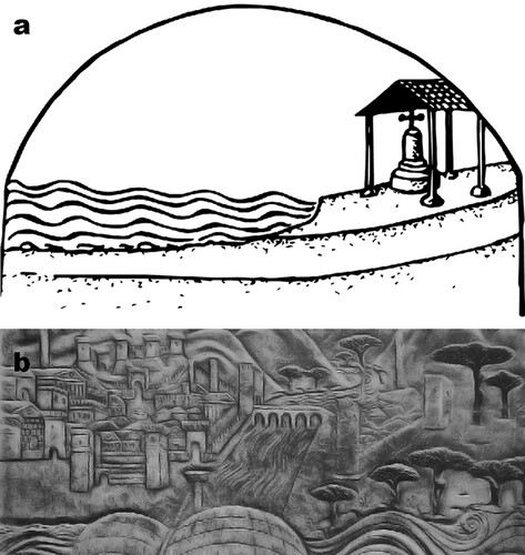
Land amid the old and new river mouths was said to be limata (= covered in silt and clay) and was rich in ponds, lakes, channels and hygrophilous vegetation (willows, osiers) (CitationDelucca, 1993). Historical testimonies about littoral water springs suggest that underground fluvial gravel lenses could have resurfaced due to later coastal dynamics, as in the case of Sacramora spring (M3 in Map). The area among M3 and M5 is called Celle (= cells, cubicles), which is from a hermitage type that arose in those inhospitable territories during the EMA (CitationSerpieri, 2004): places of worship were set in elevated areas safe from flooding, e.g. sectors of ancient elevated levees or longshore gravel bars (a).
Figure 4. 4a – Monte della Croce, in Celle territory. Bitino da Faenza, polyptic, St. Giuliano church, Rimini (from CitationDelucca, 2006, p. 1421). 4b – Rimini harbour and Tiberius Bridge, 1454. Agostino di Duccio’s bas-relief, Tempio Malatestiano, Rimini (author’s own photograph, modified).
In the X century, the name of the river changed from Ariminus to Maricula (meaning little sea), probably due to its new tendency to frequently change its path and flood surrounding areas (CitationDelucca, 2005). By micro-relief and stratigraphical analysis, five different riverbeds have been identified and related to the 1.4 Bond event (CitationBuckner, 1986) (M2, M3, M4, M5, M6a in Map). However, it is difficult to establish a straightforward time-sequence for the life-span of the river paths or reactivations of the same channel. Moreover, the existence of other riverbeds (e.g. M6b, where stratigraphic analyses have revealed at least two stages of fluvial aggradation) cannot be excluded, given the lack of a regular stratigraphic drilling grid.
Grocery cultivation started again in Viserba from the IX century onwards (CitationDelucca, 1993), probably meaning that a new main channel was established that prevented the river from wandering. The Marecchia River’s mouth probably moved back close to the town centre around the year 1000, at short distance from the Roman mouth (M1 in Map). XI century sources suggest that a harbour was created in those times (CitationSerpieri, 2004 and references therein), but it is difficult to establish its exact location. We suggest that it could have been M5, M6b or M7 if the position and dating of traces of still-standing town walls and Middle Ages’ town gates are also taken into account (CitationLeoni, 2012).
Toponyms like St. Mariae Ripae Maris (‘St. Mary Marine Scarp’, n. 7 in Map) or St. Nicolò al Porto (‘St. Nicolò in Harbour’, n. 8 in Map) recall a position close to both the harbour and seashore for an area that extends amid M6b and M1. Some authors (CitationSeveri & Zaghini, 1996) propose a reworking of the wave-cut scarp close to Rimini’s town centre in historical times, relating this to a marine transgression that actually correspond to events highlighted in CitationOrombelli, 2007 and CitationHolzhauser et al., 2005. Stratigraphic evidence confirms shallow gravel and sand deposits that could be referred to river-mouth bars.
At the end of XIV century, Rimini harbour and Tiberius bridge suffered damage from floods and strong gales and many repairs were carried out from that time onwards (CitationSerpieri, 2004). Works of art, town views and testimonies from later centuries suggest that the main Marecchia riverbed maintained the same position as in M7 from the XV century (b) to 1932-1942, when it has been diverted into its modern artificial river mouth (CitationSerpieri, 2004).
Long and snowy winters and abundant rainfall, alternated with more stable time-periods, characterized the LIA, dated between the XVI and XIX centuries. As a consequence of climate deterioration, the whole Marecchia valley suffered from intense hydrogeological instability (CitationGuerra, 2012). The Marecchia and Ausa rivers flooded the town centre multiple times, damaging structures and town walls, and forcing the administration to progressively elongate the harbour docks to prevent it from filling with gravel (CitationSerpieri, 2004). Destructive floods are well documented, such as the one that occurred in 1523 that turned Rimini into an island surrounded by the Marecchia, Ausa and Mavone rivers (the first of which submerged Tiberius bridge) and the sea (CitationSerpieri, 2004). The abundance of solid discharge, increased by extensive deforestation that took place from the XVI century in the Appennines (CitationSerpieri, 2004), enabled a delta-like growth of the river mouth and a progressive relative coastline retreatment. Many studies conducted in later centuries (CitationBianchi, 1765; CitationBoscovich, 1765; CitationCalindri, 1765; CitationCalogerà, 1763; CitationRosa, 1894; CitationTonini, 1864) investigated the rapidly extending Marecchia delta mouth; a possible evolution for the river mouth and coastline during that time can be proposed after examining the numerous historical views of the town, historical cadastres and IGM cartography (see , ) (CitationGuerra, 2016) and comparing them to local sources. The Marecchia River experienced in fact numerous diversions in its main river-channel position; in Map, image 1, the meander variations upstream from Tiberius bridge have been highlighted.
Figure 5. Rimini in 1663, coloured engraving (from CitationJoan Blaeu, Theatrorum civitatum et admirandorum Italiae, 1596-1673).
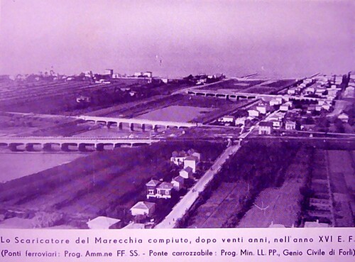
From the LIA to XX century, the abundant fluvial inputs produced a massive coastline advancement and floods continued to endanger the city centre, until the Marecchia’s river mouth was ultimately diverted inside a man-made canal (), with this work concluded in 1942 (CitationSerpieri, 2004) and the subsequent turning of the historical channel into a marshy environment, that lasted until the first renewal of the site in the 1980s.
Figure 6. Marecchia canal in 1938 (from http://artefascista.it/).
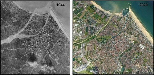
The coastline historically experienced a progressive advancement, until the increasing subsidence and a lack of fluvial or marine sediment inputs caused erosive transgressive variations to the coastal area north of M1 (CitationGuerra, 2013). The progressive lengthening of the harbour docks in recent centuries induced the regression of the coastline by interrupting the longshore currents’ transport of sediment and ephemeral landforms like ponds and swampy areas to form north of M1 (Barafonda). Several breakwaters were put in place from 1955 to 1967, but were not enough to counteract coastal erosion, meaning that a split and tomboli morphology of the coastline originated and lasted until 2000, when some of the structures were removed to build the town’s new dock. A nourishment operation was conducted and produced an 80–140 m advance of the shoreline, but the transgressive tendencies activated again shortly thereafter, causing 25 m of coastal ingression from 2002 to 2013 (CitationGuerra, 2013). The landforms southeast of the area of study mostly consisted of sand dunes (CitationAntoniazzi, 1972), but they were flattened during the XX century to facilitate touristic development. Most of the natural traits are lost today, having been removed by human intervention, or because they lie hidden under almost complete urbanization ().
Figure 7. Aerial pictures of Rimini in comparison. Notice the massive urbanization that took place after the second half of XX century in the city and surrounding areas (1944 from https://www.fold3.com/, 2020 from Google Earth).
6. Conclusions
Geomorphological elements related to past landforms and processes lie hidden under multiple stages of urbanization in Rimini, forming an intricate pattern influenced by both anthropic and natural factors, with abrupt variations corresponding to past climate deterioration events. The results of this work on the geomorphological evidences reported in the map are meaningful, especially in relation to the processes that took place in periods where the historical documentation was limited (Roman and Middle Ages). The highlighted landforms in the Marecchia River alluvial fan confirmed an evolution of the town very similar to those of other Mediterranean cases (CitationBrandolini et al., 2007, Citation2019; CitationDall’Aglio et al., 2017), especially the evident response of transition systems (river and coastal) to global climatic events of greater impact (EMA-CD and LIA). Historical sources helped in understanding the evolution of the site particularly in examining recent times. An interdisciplinary approach to the subject could lead to new heritage-promotion scenarios, in which cultural heritage is strictly linked to geological and geomorphological heritage.
Software
The geological and geomorphological map elements have been georeferenced in QGIS 3.8.3. The final layout of the map was performed using Adobe Illustrator CC 2018.
VG_CG_ON_Map.pdf
Download PDF (31.8 MB)Acknowledgements
We kindly thank the Municipality of Rimini, Rimini SITUA, Emilia-Romagna region and Biblioteca civica Gambalunga for providing useful data.
Disclosure statement
No potential conflict of interest was reported by the author(s).
Additional information
Funding
References
- AA.VV. (2005). Note illustrative della Carta Geologica d’Italia alla scala 1:50.000. Foglio 256 - Rimini. APAT, Servizio Geologico d’Italia, Regione Emilia-Romagna.
- Antoniazzi, A. (1972). Variazioni della linea di spiaggia lungo il litorale adriatico tra le foci dei fiumi Savio e Foglia nel periodo dal 1820 al 1970. Camera di Commercio, Forlì, 1-35 e appendice cartografica.
- Antoniazzi, A. (1976). L'erosione marina nel litorale tra Cervia e Pesaro. Camera di Commercio, Forlì, 1–161.
- Antoniazzi, A. (1996). Il riminese durante l’evoluzione dell’uomo. In M. Biordi, A. Antoniazzi & M. Barogi (Eds), Alle origini della storia: il Paleolitico di Covignano (pp. 67–78). Musei Comunali.
- Bianchi, G. (1765). Parere sopra il porto di Rimino del dottor Giovanni Bianchi membro dell'Accademia delle Scienze di Berlino, D. Ricci, Pesaro.
- Boscovich, R. G. (1765). Del porto di Rimini Memorie. D. Ricci, Pesaro. ETH-Bibliothek Zürich, Rar 788. https://doi.org/10.3931/e-rara-11408
- Brandolini, P. (2017). The outstanding terraced landscape of the Cinque Terre coastal slopes (Eastern Liguria). In M. Soldati & M. Marchetti (Eds), Landscapes and landforms of Italy, World geomorphological Landscapes (pp. 235–244). Springer International Publishing.
- Brandolini, P., Cappadonia, C., Luberti, G. M., Donadio, C., Stamatopoulos, L., Di Maggio, C., Faccini, F., Stanislao, C., Vergari, F., Paliaga, G., Agnesi, V., Alevizos, G., & Del Monte, M. (2019). Geomorphology of the Anthropocene in Mediterranean urban areas. Progress in Physical Geography: Earth and Environment, 44(4), 461–494. https://doi.org/10.1177/0309133319881108
- Brandolini, P., Faccini, F., Paliaga, G., & Piana, P. (2017). Urban geomorphology in coastal environment: Man-made morphological changes in a seaside tourist resort (Rapallo, Eastern Liguria, Italy). Quaestiones Geographicae, 36(3), 97–110. https://doi.org/10.1515/quageo-2017-0027
- Brandolini, P., Faccini, F., Paliaga, G., & Piana, P. (2018). Man-made landforms survey and mapping in an urban historical center on coastal Mediterranean environment. Geografia Fisica e DinamicaQuaternaria, 41, 24–34. https://doi.org/10.4461/GFDQ.2018.41.2
- Brandolini, P., Faccini, F., Robbiano, A., & Terranova, R. (2007). Geomorphological hazard and monitoring activity in the western rocky coast of the Portofino Promontory (Italy). Quaternary International, 171-172, 131–142. https://doi.org/10.1016/j.quaint.2006.11.006. ISSN: 1040-6182.
- Buckner, H. (1986). Mańs impact in the evolution of the physical environment in the Mediterranean region in historical times. GeoJournal, 13(1), 7–17. https://doi.org/10.1007/BF00190684
- Büntgen, U., Myglan, V. S., Ljungqvist, F. C., McCormick, M., Di Cosmo, N., Sigl, M., Jungclaus, J., Wagner, S., Krusic, P. J., Esper, J., Kaplan, J. O., De Vaan, M. A. C., Luterbacher, J., Wacker, L., Tegel, W., & Kirdyanov, A. V. (2016). Cooling and societal change during the Late Antique little Ice Age from 536 to around 660 AD. Nature Geoscience, 9(3), 231–236. https://doi.org/10.1038/ngeo2652
- Calindri, S. (1765). Memoria sopra il Porto di Rimino compilata dal signor Serafino Calindri con note del sig. Marco Chillenio, Rimino 1764, D. Ricci, Pesaro.
- Calogerà, D. (1763). Due discorsi dell'Ab. Giovanni Antonio Battarra Professor Pubblico di Filosofia, e del Seminario nella città di Rimino sua Patria, fatti co’ suoi Scolari, sopra la fabbrica del Porto di quella Città, Opuscoli, X, Venezia.
- Cesaretti, C. (2004). Il ponte sull’Ausa a Rimini e la sua storia. In S. Quilici Gigli & L. Quilici (Eds), Viabilità e insediamenti nell’Italia antica, Atlante tematico di topografia antica (pp. 113–119). L’Erma di Bretschneider.
- Clementini, C. (1617). Raccolto Istorico della fondatione di Rimino e dell'origine, e vite de’ Malatesti: con vari, e notabili fatti en essa Città, e fuori di tempo in tempo successi. Vol. I 1617, Vol. II 1627.
- Coltorti, M. (1991). Modificazioni morfologiche oloceniche nelle piane alluvionali marchigiane: alcuni esempi nei fiumi Misa, Cesano e Musone. Geogr. Fis. Din. Quat., 14, 73–86.
- Cremonini, S. (1995). Per un profilo delle problematiche geostoriche riminesi. In A. Calbi & G. Susini (Eds), Pro Poplo Ariminese (pp. 253–328). F. Lega.
- Dall’Aglio, P. L. (2000). Geografia fisica e popolamento di età romana. In M. Marini Calvani (Ed), Aemilia. La cultura romana in Emilia Romagna dal III sec a.C. all’età costantiniana (pp. 51–56). Marsilio.
- Dall’Aglio, P. L., De Donatis, M., Franceschelli, C., Guerra, C., Guerra, V., Nesci, O., Piacentini, D., & Savelli, D. (2017). Geomorphological and anthropic control of the development of some Adriatic historical towns (Italy) since the Roman Age. Quaestiones Geographicae, 36(3), 111–123. https://doi.org/10.1515/quageo-2017-0028
- De Donatis, M., Nesci, O., Savelli, D., Pappafico, G., & Susini, S. (2019). Geomorphological evolution of the Sena Gallica site in the morpho-evolutive Quaternary context of the Northern-Marche coastal sector (Italy). Geosciences, 9(6), 272–217. https://doi.org/10.3390/geosciences9060272
- Del Monte, M., D’Orefice, M., Luberti, G. M., Marini, R., Pica, A., & Vergari, F. (2016). Geomorphological classification of urban landscapes: The case study of Rome (Italy). Journal of Maps, 12(sup1), 178–189. https://doi.org/10.1080/17445647.2016.1187977
- Deline, P., & Orombelli, G. (2005). Glacier fluctuations in the western Alps during the Neoglacial, as indicated by the Miage morainic amphitheatre (Mont Blanc massif, Italy). Boreas, 34(4), 456–467. https://doi.org/10.1111/j.1502-3885.2005.tb01444.x
- Delucca, O. (1993). Viserba nel Medioevo. In Viserba e … Viserba (pp. 127–197). Luisè.
- Delucca, O. (2000). Idrografia riminese e interventi idraulici nel Medioevo. Atti e memorie della Deputazione di storia patria per le province di Romagna, LI, 209–236.
- Delucca, O. (2005). Una terra fra le acque: il borgo e il territorio di Sant’Andrea nel Medioevo. In Sant’Andrea, un borgo fra le acque (pp. 29–64). Luisè.
- Delucca, O. (2006). L’abitazione riminese nel Quattrocento. In S. Patacconi (Ed), La casa cittadina, parte seconda (p. 1421). Pazzini.
- Elmi, C., Colantoni, P., Gabbianelli, G., & Nesci, O. (2001-2002). Holocene shorelines along the central adriatic coast (Italy). GeoActa, 1, 27–36.
- Elmi, C., Fanucci, F., Nesci, O., Beer, G., & Pignocchi, A. (1994). Evoluzione olocenica della linea di riva adriatica dal F. Reno al F. Potenza (Italia centrale). Il Quaternario, 7(1), 305–310.
- Elmi, C., Nesci, O., con il contributo di Giorgi, G., & Zecchi, R. (1991). Forme e movimenti recenti dell'alta pianura emiliano-romagnola. Mem. Descr. Carta Geol. d’It., 46, 497–502.
- Fontemaggi, A., & Piolanti, O. (1995). Il popolamento nel territorio di Ariminum: Testimonianze archeologiche. In A. Calbi & G. Susini (Eds), Pro Poplo Ariminese (pp. 253–328). F. Lega.
- Guerra, C. (2012). Barburane, galaverne e nevoni. Storia del clima della Repubblica di San Marino. Repubblica di San Marino.
- Guerra, V. (2013). Variazioni della linea di riva tra le foci del fiume Marecchia e del torrente Marano (area costiera romagnola). Scienze Geologiche e Gestione del Territorio, dissertation, University of Urbino “Carlo Bo”, unpublished.
- Guerra, V. (2016). Ricerche di geomorfologia urbana nel territorio di Rimini con particolare riferimento al Deterioramento Climatico Altomedievale. Geologia applicata e Geoinformatica, dissertation, University of Urbino “Carlo Bo”, unpublished.
- Helama, S., Jones, P. D., & Briffa, K. R. (2017). Dark ages cold period: A literature review and directions for future research. The Holocene, 27(10), 1600–1606. https://doi.org/10.1177/0959683617693898
- Holzhauser, H., Magny, M., & Zumbuühl, H. J. (2005). Glacier and lake-level variations in west-central Europe over the last 3500 years. The Holocene, 15(6), 789–801. https://doi.org/10.1191/0959683605hl853ra
- Joan, B. Theatrorum civitatum et admirandorum Italiae, 1596-1673. Biblioteca civica Gambalunga, DP 73, Rimini.
- Leoni, N. (2012). Le mura bassomedievali di Rimini: analisi archeologica. Scienze dell’Antichità: letterature, storia e archeologia, dissertation, Università Ca’ Foscari di Venezia (p. 187).
- Longares Aladrén, L. A., Peña-Monné, J. L., Pérez-Lambán, F., & Escudero, F. (2013). An approach to topographic modelling of Caesaraugusta (Central Ebro basin) from historical cartography and the Creation of digital elevation models (Dems). In F. Vermeulen & C. Corsi (Eds), Non-Destructive Approaches to complex archaeological sites in Europe: A round-up (pp. 68–69). Ghent University.
- Nesci, O., Savelli, D., & Troiani, F. (2012). Types and development of stream terraces in the Marche Apennines (central Italy): a review and remarks on recent appraisals. Géomorphologie: Relief, Processus, Environnement, 18(2), 215–238. https://doi.org/10.4000/geomorphologie.9838
- Orombelli, G. (2007). Le variazioni dei ghiacciai alpini negli ultimi 10 mila anni. Quaderni della Società Geologica Italiana, 1, 5–12.
- Ortalli, J. (1995). Nuove fonti archeologiche per Ariminum. In A. Calbi & G. Susini (Eds), Pro Poplo Ariminese (pp. 469–529). F. Lega.
- Ortalli, J. (2000). Rimini: la città. In M. Marini Calvani (Ed), Aemilia. La cultura romana in Emilia Romagna dal III sec a.C. all’età costantiniana (pp. 501–506). Marsilio.
- Ortalli, J. (2010). Archeologia della città di Rimini fra paganesimo e cristianità. Storia della chiesa riminese vol. I - Dalle origini all’anno 1000, 141–171.
- Ortolani, F., & Pagliuca, S. (2007). Evidenze geologiche di variazioni climatico-ambientali storiche nell’Area Mediterranea. Quad. SGI, 1, 14–18.
- Parea, G. C. (1986). I terrazzi marini tardo-pleistocenici del fronte della catena appenninica in relazione alla geologia dell’avanfossa adriatica. Mem. Soc. Geol. It, 35, 913–936.
- Peña Monné, J. L., Sampietro Vattuone, M. M., Longares Aladrén, L. A., Pérez Lambán, J. V., Sánchez Fabre, M., Alcolea Gracia, M., Vallés, L., Echeverría, M. T., & Baraza, C. (2018). Holocene alluvial sequence of Valderazagoza (Los Monegros) in the paleoenvironmental context of the Ebro basin (Spain). Geographical Research Letters, 44(1), 321–348. https://doi.org/10.18172/cig.3358
- Preti, M., De Nigris, N., Morelli, M., Monti, M., Bondignore, F., & Aguzzi, M. (2008). Stato del litorale emiliano romagnolo all’anno 2007 e piano decennale di gestione. I Quaderni di ARPA 2008.
- Ravara Montebelli, C. c. d. (2002). Aqua Ariminensis. Approvvigionamento, conduzione e utilizzo nella città romana. Cat. Mostra a cura di Ravara Montebelli, C., Rimini.
- Reynard, E., Pica, P., & Coratza, P. (2017). Urban geomorphological heritage. An overview. Quaestiones Geographicae, 36(3), 7–20. https://doi.org/10.1515/quageo-2017-0022
- Rosa, M. (1894). Biografia di G. A. Battarra. In Biografie e ritratti di Uomini Illustri di tutto lo Stato Pontificio - Serie romagnola (pp. 106–108). Hercolani.
- Roveri, M., Correggiari, A., Asioli, A., & Trincardi, F. (2001). Ultra high-resolution marine record of palaeoenvironmental changes in the last 5000 years. Archivio di Oceanografia e Limnologia, 22, 223–234.
- Serpieri, A. (2004). Il porto di Rimini dalle origini a oggi: tra storia e cronaca. Luisè.
- Severi, P., & Zaghini, M. (1996). Alluvioni terrazzate del conoide del fiume Marecchia. Evoluzione recente della linea di costa e valutazioni in merito alla subsidenza nell’area riminese. In M. Biordi, A. Antoniazzi & M. Barogi (Eds), Alle origini della storia: il Paleolitico di Covignano (pp. 79–89). Musei Comunali.
- Tonini, L. (1856). Rimini dal principio dell'era volgare all’anno 1200. In Storia civile e sacra riminese. Malvolti ed Ercolani.
- Tonini, L. (1864). Il Porto di Rimini, brevi memorie storiche. Tip. Fava e Garagnani.
- Veggiani, A. (1983). Degrado ambientale e dissesti idrogeologici indotti dal deterioramento climatico nell’alto Medioevo in Italia. I casi riminesi. Studi Romagnoli, 34, 123–146.
- Veggiani, A. (1986). L’ottimo climatico medievale in Europa. Testimonianze lungo la fascia costiera padano-adriatica. Studi Romagnoli, 37, 1–26.
- Veggiani, A. (1988a). Il ponte antico di San Vito: variazioni del clima e mutamenti dei corsi d’acqua e delle strade dall’antichità al Medioevo tra Marecchia e Pisciatello. In M. Biordi, et al., San Vito e Santa Giustina: contributi per la storia locale (pp. 31–68). Maggioli.
- Veggiani, A. (1988b). La falesia morta e i depositi olocenici antistanti lungo la fascia costiera adriatica fra Cesenatico e Cattolica. In M. Bondesan, C. Elmi, O. Nesci, R. Dal Cin & A. Veggiani (Eds), Guida alle escursioni (pp. 71–82). Gruppo Nazionale di Geografia Fisica e Geomorfologia, Riunione Annuale.
- Veggiani, A. (1991). Le vicende geologiche del territorio riminese. Storia illustrata di Rimini, 4, 1185–1200.
- Vita-Finzi, C. (1969). The Mediterranean Valleys. Cambridge Univ. Press. 140 p.
- Zaghini, M. (1991). Caratteri geomorfologici e idrografici della Valmarecchia. Studi Romagnoli, 42, 25–55.
- Zaghini, M. (1993). Caratteri geomorfologici e idrografici del comprensorio di Viserba. In Viserba e … Viserba (pp. 11–24). Luisè.
- Zaghini, M. (1994). I Beni geomorfologici nel riminese. Studi Romagnoli, 45, 135–160.
- Zaghini, M. (1995). Tra passato e futuro. In Sant'Andrea, un borgo fra le acque (pp. 65–80). Luisè.
- Zaghini, M. (2000). Considerazioni geomorfologiche e idrologiche derivanti dall’analisi del rilievo del centro storico di Rimini. Studi romagnoli, 51, 723–743.