
ABSTRACT
Geographers, cartographers, and related social scientists are increasingly locating the (geo)politics of the vernacular within volunteered geographic information, the geoweb, and other digital technologies that enable the production of new maps. We instead focus our attention on ‘old’ cartographic practices. We contend that map-based community activism and geopolitics continue to occur in ways that much research has left behind in its shifted attention toward digital geographies. We conceptualize vernacular counter-mapping, as practiced by Grow Calgary a community urban farm located on public land, by focusing on vernacular cartographic method and mode. We argue first that the vernacular exists not just in the production of new maps but also in the practice of altering and re-narrating existing maps, and, second, that the vernacular exists not just in the new modes of VGI and distributed/crowdsourced data production, but in the mode of leveraging official, static state maps to make legible situated knowledges.
1. Introduction
Recent transformations in social and technological assemblages raise new questions about the ways in which maps function to shape political activities. Groups and individuals produce massive amounts of spatial data on a daily basis (CitationMiller & Goodchild, 2015), and these data facilitate new political relations: digital spatial technologies play a key role in everything from mass surveillance (CitationZuboff, 2019) to new subject production (CitationGabrys, 2014). Geographers and kindred social scientists have sought to make sense of these new relations with conceptual frameworks such as the geoweb and volunteered geographic information (VGI), highlighting the delegation of mapping ‘responsibility’ from the state to various publics (CitationLeszczynski, 2012).
In this article, we remind researchers of the continued geopolitical importance of ‘old’ forms of mapping. We draw on critical cartography research (CitationCrampton & Krygier, 2006) to show that forms of counter-mapping (CitationPeluso, 1995) that rely on static vernacular maps remain an important, and contested, strategic resource for community activism and geopolitics. In this, the politics of the ‘geo’ – by definition, the focus of geopolitical literature – can be manifest through vernacular counter-cartographies.
Empirically, this paper analyzes a dispute over the expansion of transportation infrastructure through public urban farmland in Calgary, Alberta. Grow Calgary,Footnote1 an urban farming initiative operating a volunteer-donate model, contested the way provincial planners mapped the boundary of the public land they farm and the extent of the new highway construction’s impact. We frame this dispute as a spatial conflict mediated by maps, in order to examine the modes and methods of counter-mapping practices that Grow Calgary activists undertook to undermine state claims. We demonstrate how politics of the vernacular are present in, first, the method of cartographic practice (i.e. the techniques an actor might engage to produce maps), and second, in the mode of cartographic practice (i.e. the assemblages through which the corpus of geographic data are produced). For Grow Calgary, a geopolitics emerged in the re-narrating of existing cartographic products, rather than simply the production of original first-hand maps. That is, it emerged when Grow Calgary activists subverted official state claims to land by re-envisioning and amending official state maps based on their lived experience of working the land.
We synthesize these two aspects of vernacular cartographies by arguing that our case illustrates how vernacular counter-mapping can be used as a tool for community activist geopolitical practice (see CitationSparke, 1995). To put this another way, whereas recent attention in disciplinary geography has turned toward the ease and accessibility of new mapping technologies, we demonstrate here the continued geopolitical importance of more longstanding, ‘old’ technologies. It is through these means that state claims to land continue to be challenged in the ‘digital geographies’ era (see CitationAsh et al., 2018).
2. Counter-mapping and ‘the vernacular’; community activism and geopolitics
2.1. Critical, counter- and vernacular mapping
In 1995, in the midst of the critical Geographic Information System (GIS) debates comprising much of the attention of mapping studies, CitationPeluso (1995, p. 384) coined the term ‘counter-mapping’ to describe the practices of groups and individuals performing a political praxis through cartographic products.Footnote2 Peluso argued that if maps possess social power – notably demonstrated by CitationHarley (1989) – that power can be mobilized by not only the state for governance and subject production, but also by those very subjects to resist state power.Footnote3 Concomitantly, participatory mapping and participatory GIS more broadly were seeking to incorporate citizens and civil society groups into the mapping process (CitationWeiner et al., 1995). The goal in all these exercises, and indeed a hinge for critical GIS debates in general, was to leverage the seeming legitimacy of cartographic forms of knowledge (CitationElwood, 2002) to bring ‘situated knowledges’ (CitationHaraway, 1988) into public dialogue. Such research assumed that cartographic products produced by marginalized or subaltern groups would wield newfound power against state-based spatial claims. While it was situated within broader conversations under the umbrella of ‘critical cartography’ (CitationPerkins, 2003), Peluso’s piece in particular showed the indeterminacy of cartographic technologies: maps and mapping practices can equally play into state interests as well as resist them, often with the same geographic information represented.Footnote4
Many of these assumptions provided the foundation for later understanding the collection of digital technologies variously named ‘VGI’ (CitationGoodchild, 2007), ‘the geoweb’ (CitationElwood, 2010), ‘neogeography’ (CitationTurner, 2006), and others, emerging in the mid-2000s. These technologies, of which we focus here on VGI, entailed crowdsourced mapping platforms such as OpenStreetMap (CitationHaklay & Weber, 2008) and Google Earth (CitationCrutcher & Zook, 2009), allowing, according to widely-held conceptions, nearly unrestricted access to the production of maps and spatial data, or democratizing spatial data production and analysis (see, for example, CitationJohnson & Sieber, 2012). Researchers such as CitationZook et al. (2010), CitationHaklay (2010), and CitationGoodchild and Glennon (2010) saw VGI as a way of revolutionizing data production in high-stakes, quickly changing contexts, largely because of the way such technologies mobilize large numbers of uncoordinated groups and individuals. Many of the accounts at the time premised on a mild form of technological utopianism, in which advances in technology led to advances in social organizing, governance, and democratic participation, assumptions brought into question by those drawing on earlier critical GIS debates (CitationElwood, 2010). For all these latter interlocutors, VGI’s potential lies in the way it captures and represents ‘vernacular’ knowledges (CitationGerlach, 2010, Citation2013) rather than institutional or state-based knowledges – clearly reflecting earlier theorizations of counter-mapping. To appropriate the language of CitationDodge et al. (2009), the focus of VGI research is often on the mode of mapping – the way in which it emerges from large numbers of individuals rather than individual mappers; the work focusing on VGI’s methods of mapping might draw attention to the fact that most of these data are produced through digital systems with ‘apps,’ easily accessible software such as Google Earth or Esri Online, or navigation systems such as Waze.
Recent work at the intersection of technology and society synthesizes across these concerns. Despite hubristic claims of totalizing societal shifts with the onset of Big Data, the aphorism that ‘data do not speak for themselves’ (CitationRatcliffe, 1983, p. 149) remains firmly entrenched in critical social science, echoed in part by CitationGitelman’s (2013) insistence that the notion of raw data ‘is an oxymoron.’ CitationDourish and Cruz (2018) expand this idea to argue that data – or, for our purposes, cartographic representations – must be narrated to become legible within particular political contexts. That is to say, representations of the world gain meaning through the ways in which their creators or interlocutors frame those representations’ interventions. Such a critical role for narration is in concert with the idea that maps do not convey singular, static ideas, but rather are ontogenetic, process-based, and performative (CitationCrampton, 2009; CitationKitchin & Dodge, 2007).
2.2. Counter-maps as a tool for community activism and (geo)politics
Geopolitics has historically been understood as the interactions between nation-states at a global scale, but has recently expanded beyond statecraft to account for ‘minor’ actors and ‘lower’ scales (CitationDittmer & Dodds, 2008; CitationDodds & Sidaway, 1994; CitationGerlach, 2015). Within this conceptualization, maps are geopolitical representations, imaginaries, discourse, and practice (CitationAtkinson & Dodds, 2000; CitationBoria, 2008; CitationShapiro, 2007; CitationSparke, 1998). By extension, counter-maps challenge state claims through providing ‘minor’ spatial frames that subvert official claims in the ‘major register’ over territory (CitationCounter Cartographies Collective, Dalton, & Mason-Deese, 2012; CitationHarris & Hazen, 2005; CitationKatz, 1996). Counter-maps’ potential power as a tool for community activism and (geo)politics stems from their ability to pitch on-the-ground experiences, imaginaries, and narratives against the claims of those in institutionalized power.
Counter-maps are often created as acts of resistance in various (geo)political struggles. While such a point may seem mundane and obvious, we repeat it here because the devolution of state control over map-making to the public is usually associated with new forms of digital map-making like the geoweb and VGI (CitationLeszczynski, 2012). In both of these cases – counter-maps and the geoweb – scholars have identified ‘the vernacular’ as a key cartographic characteristic, wherein mapping processes and outputs reflect knowledges and practices of multiple publics (CitationGerlach, 2010, Citation2013). For CitationGerlach (2013, p. 23), ‘Vernacular mappings are non-statist, extra-institutional, participatory, cartographic practices, either digital or analogue in their composition, in which such performances are not taken to be technologies of capture, but as techniques of addition.’ The vernacular, then, directs our attention to the multiple producers, uses and users, and materialities of geographic data. Vernacular maps are ontogenetic: their meaning and possible uses are not pre-defined by the map-maker but come into being through repeated uses and re-narrations (see CitationKitchin & Dodge, 2007). Vernacular maps expand the conceptual limits of what can be captured in cartographic products; at the same time, they can advance our understanding of geopolitics in that they mobilize community activists to conjure other spatial representations in pursuit of alternative futures. As such, here we analyze community activists’ cartographic interventions to advance geographers’ understanding both of contemporary mapping practices and of a ‘minor’ (geo)politics.
3. Grow Calgary: an urban farm on public land ‘maps back’
Grow Calgary is located on 11 acres of land within the Calgary municipal boundary. It claims to be Canada’s largest ‘community’Footnote5 urban farm and is unique because it is situated on public (province of Alberta, Canada) land, relies exclusively on volunteer labor, and donates all their production to low-income Calgarians. After six growing seasons, in 2018, the Alberta provincial government instructed Grow Calgary to relocate the farm under the premise that the land was needed to expand transportation infrastructure. Grow Calgary was willing to concede a portion of the land but ultimately refused to move, upholding that the province did not require all of the farm’s land. They substantiated this claim by pointing out that the farm is located on two parcels, is partly in the West Ring Road/Transportation Utility Corridor (West RR/TUC), and is also on surplus land (see ). In their campaign to remain where they were, Grow Calgary procured more than 2500 signatories to a petition,Footnote6 made multiple media appearances,Footnote7 and produced a series of maps that they shared on social mediaFootnote8 to challenge the province’s demand.
Figure 1. Maps like this one showed Grow Calgary’s location adjacent to Calgary’s Ring Road/Transportation Utility Corridor (RR/TUC).
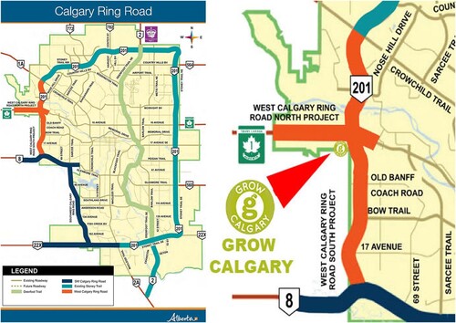
The province and Grow Calgary’s dispute over public urban farmland were mediated by maps in two ways. First, the province framed its purpose and need through maps; and second, Grow Calgary also, through maps, challenged those claims, politicized the issue, and negotiated a lease for a new piece of public land. More precisely, the province sent Grow Calgary maps to substantiate the imperative for the farm to vacate the premises. In protest, Grow Calgary produced counter-maps to position the farm mostly outside the route planned for infrastructure expansion (see ) and to show inconsistencies in the provinces’ spatial framings through time (see ). Grow Calgary founder and president Paul Hughes claimed in a personal interview with us that ‘maps have been the most effective way in which we communicate our story.’ In this, Grow Calgary’s primary strategy in their struggle to remain on public provincial land was to ‘map back.’
Figure 2. Grow Calgary’s counter-map locate the farm on surplus land outside the route planned for infrastructure expansion.
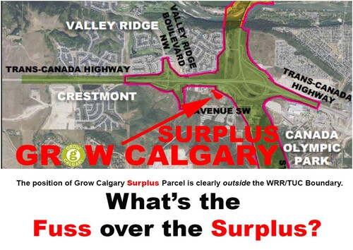
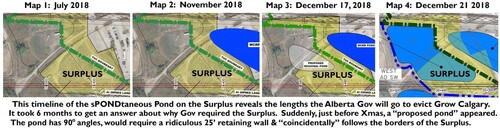
Figure 3. Grow Calgary created a timeline to show inconsistencies in the province’s spatial framings.
Methodologically, Hughes himself makes most maps with Photoshop, although other Grow Calgary activists and volunteers do inform his process. Hughes uses maps showing established information such as TUC boundaries, road locations, and surplus land, to decide what information, perspectives, and knowledges to include when revising maps. He and Grow Calgary revise these existing maps with their own data and knowledge, to contrast them with the province’s development projections. Once these maps are revised, there is a collective effort to disseminate the new maps, with the goal of swaying the public’s perception of events like the surplus land controversy at hand.
Access to land is perhaps the biggest challenge farmers face across the world (CitationFernandes, 2016; CitationPritchard et al., 2015). This is especially the case for urban farmers in the Global North (CitationEditors, 2015; CitationRoman-Alcalá, 2015) who must contend with limited access to land – i.e. urban land is mostly zoned for other-than-agricultural purposes (CitationNewman et al., 2015) – and high real estate costs. Grow Calgary is unique – both from other cases in the literature, and in comparison to other backyard SPIN- (Small Plot Intensive) farmers in Calgary (see CitationBeckie & Bacon, 2019; CitationSchneider & Fast, 2017) – in that it has been able to create a truly radical volunteer-donate model operating beyond market constraints of revenue creation, profit orientation, and salaried labor. This approach is only possible because Grow Calgary farms public urban farmland without incurring high land rent costs. This fact underscores the importance of Grow Calgary’s struggle to remain on public land.
Certain characteristics of Calgary make this case even more interesting. First, the sprawling nature of the city and the amount of vacant provincial land available in the RR/TUC results in under-utilized land resources, leading local food activists to claim, as Paul Hughes did in a personal interview with us, that Calgary has ‘the greatest potential for urban agriculture in the world.’Footnote9 Regardless of the authenticity of the bold claim, this reflects broader Calgarian conversations about, as well as support for, making public land available to agriculture in the city. As evidence of growing support, other urban farming efforts in Calgary that are not associated with Grow Calgary have begun to access unused public urban land on the RR/TUC for farming, like The New Urban Farm Partnerships’ project in association with the Calgary Catholic Immigration Society.Footnote10 Two city-owned vacant lots within Calgary have similarly been made available for other not-for-profit, albeit commercial, urban farming initiatives.Footnote11
4. Methodology
The case presented here stems from a research project into urban food activism in Calgary that took place from January 2017 to April 2019. In this qualitative case study, we drew significantly on ethnography’s insistence that the researcher learns by participating in the studied communities (CitationHerbert, 2000). We embedded ourselves in this community’s operations as participant-observers and volunteers, attending its meetings and farming its land. We also conducted 25 semi-structured interviews with key Calgary food activists (CitationRubin & Rubin, 2005), and performed an archival analysis of recent media stories around this series of events. We present here our deconstructions of the provincial government’s maps and Grow Calgary’s counter-maps (CitationSparke, 1995), supported and complemented by a discourse analysis of our interviews and supplementary research data (CitationDittmer, 2010).
5. Vernacular cartographic method
In the sections that follow, we contend that map-based community activism and geopolitics continue to occur in ways that much research has left behind in its shifted attention toward digital geographies. While geographers, cartographers, and related social scientists are increasingly locating the (geo)politics of the vernacular within VGI, the geoweb, and other digital technologies that enable the production of new maps, we instead focus our attention on ‘old’ cartographic practices.
We argue first that the vernacular exists not just in the production of new maps but also in the practice of altering and re-narrating existing maps. Grow Calgary challenged the state’s claims to land by subjecting them to a range of re-framings and alternative narrations that we consider to be ‘vernacular’ counter-maps. Here, contra CitationPeluso’s (1995) conception of counter-maps and the dominant conception of participatory mapping as the production of new maps, we see something more akin to CitationElwood’s (2009) centering of interpretation as a guiding logic for participatory map-making. By altering, amending, and re-narrating spatial claims in their own counter-maps, Grow Calgary intended both to undermine the legitimacy of the state’s narrative, and also to secure the public’s support. They did this first, by having their counter-maps demarcate Grow Calgary’s land from the land the province claimed to need for the Ring Road expansion project (). is one example of the many counter-maps produced that shows the West RR/TUC, land that would be unavailable to Grow Calgary and could substantiate the province’s imperative to relocate the farm. In this figure, Grow Calgary draws attention to the small plot of land on which it is located, and that this map renders outside the West RR/TUC. In other words, Grow Calgary used this map to argue that the farm is located on surplus land outside the area designated for the road expansion project.
Second, Grow Calgary created a time-series map that conveyed contradictory spatial claims that the province had made at different stages of infrastructure expansion planning (see ). In this time-series, one can see the way in which the blue masses of water bodies gradually increase in size to occupy more of the map between the months of July and December 2018. In Grow Calgary’s supplementary narrative text, they called particular attention to the ‘coincidental’ way in which the pond’s representation neatly follows the border of the surplus land on which Grow Calgary operates. In this re-narration, Grow Calgary takes official state maps and questions both the growth of the water body and the shape it assumes; the implication here is that by drawing into question the state’s cartographic claims, the public is likely to perceive the situation as one in which a major, powerful actor is ‘bullying,’ so to speak, a less powerful and perhaps more altruistic organization.
The reason Grow Calgary undertook these cartographic practices was to raise the public’s consciousness to a range of alternatives and possibilities. While the established literature on counter-maps and vernacular mapping mostly speak of ‘new’ maps – i.e. the production of cartographic products that were previously non-existent, a vernacular counter-mapping, as practiced by Grow Calgary, involved taking maps that already existed and altering or amending them to tell a different story. At the most general level, this raises important conceptual questions about geographic representation path-dependency in counter-mapping and the ways in which those representations frame the political discourses available to community organizations (CitationFraser, 1988). In leveraging existing state-produced maps, organizations are limited to the baseline representations that were in the map to begin with; in our case, Grow Calgary potentially ceded some negotiating power by admitting the truth-value of any province-generated boundary (such as in ). The tactic in is to illuminate absurdity through juxtaposing multiple timeframes, and therefore does not challenge the truth-value of any particular map so much as of the representations as a whole. Taken together, revising existing maps sets soft parameters around the politics that an organization may mobilize. Thus, while these maps are the site for creative re-narration, they are simultaneously the terrain of power and control. As such, here we remind researchers that vernacular mapping consists not just in making new maps, but also in altering existing ones, and serves as a useful counter-mapping tactic. This tactic has ramifications for community activism and geopolitics.
6. Vernacular cartographic mode
The second component of our argument is that the vernacular exists not just in the new modes of VGI and distributed/crowdsourced data production, but in the mode of leveraging official, static state maps to make legible situated knowledges. Grow Calgary worked with static cartographic representations, rather than data-based and interactive systems like GIS or web mapping. As noted above, within geographic technology studies, the vernacular has been conceptualized as a theoretical characteristic of VGI and the geoweb (CitationGerlach, 2010, Citation2013). We concur with this argument but contend that the vernacular’s conceptual purchase can be extended to more longstanding simple digital and even analog cartographic forms, insofar as they work as a foundation – a basemap – for mapping situated knowledges.
Critical for understanding the case at hand, Grow Calgary’s counter-maps did not rely on digital geographic data for their cartographic production. Instead, Grow Calgary departed from most available data-based representations of their situated knowledges, and inscribed them as annotations and markings on top of ‘official’ maps to make them legible to province officials and the public.
Grow Calgary’s mapping process can best be understood as ‘community mapping’ (CitationPerkins, 2007), but differs from those empirical examples that highlight the role of computational technologies like GIS or web mapping. Rather than create a web-based system that – according to some scholars – ‘anyone’ is able to easily create, Grow Calgary enacted minimal efforts to re-narrate the official maps; in one common approach, they would add their amendments directly into the province’s map products through, for example, adding a layer in a Photoshop file. Grow Calgary adopted this approach of adding representational ‘layers’ on the official, state cartographic products partly because it made the new, re-narrated products more amenable to reproduction. No expert mapping or computer knowledge was required. Specifically, Paul Hughes told us that:
You have to create an understanding about something that a lot of people don’t understand, and the best way to do it isn’t a thousand words: the best way to do it is one picture [i.e. a map]. And if it’s done with some degree of Photoshop or visual prowess where you can actually capture the essence of [the conflict], then people can read it and go: ‘ok, I get it’.
CitationWood et al.’s (2010, p. 111) insistence that ‘counter-mappers can make gateau out of technological crumbs’ is helpful in thinking through the range of cartographic practices with which organizations interact as they work to enact community activism and (geo)politics.
In this case, Grow Calgary activists are not making original digital maps; they are proposing spatial arguments by altering already existing maps to account for their situated knowledges. Grow Calgary activists experience, interpret, and, through vernacular cartographic practices represent their space differently through altered vernacular maps. This act of turning official state maps into vernacular cartographic products is a practice of refusal. They refuse to have their situated knowledges be undermined by official state claims.
Counter-mapping research has, as of late, been largely conditioned to the interactive-digital, leading disciplinary debates to neglect the continued importance of ‘simple’ digital and analog technologies. The Grow Calgary case shows that while the vernacular certainly characterizes contemporary digital mappings and their attendant geopolitics, it remains as well in re-narrations of official, analog (or at least, static) state-produced maps. Static maps still matter for vernacular counter-mapping as in the Grow Calgary case.
7. Conclusion
Grow Calgary’s vernacular counter-maps led to a largely successful campaign that allowed them to lease a different parcel of public provincial land. While Grow Calgary’s struggle, including the use of counter-maps, did not result in the farm remaining where it was, it did create conditions for them to receive a new piece of land from the province, as well as a promise of support in the form of farm equipment relocation and basic infrastructure construction (e.g. road, water, power). However, Grow Calgary’s future remains uncertain given recent disputes over funding compounded by the 2019 provincial government change.Footnote12
Synthesizing across the previous two arguments, we have shown that vernacular counter-maps remain an important tool for community activism and (geo)politics in the digital-geographic milieu of Big Data, data science, web mapping, and real-time visualization. These assemblages of expertise, skills, technologies, and institutional sanctions have been positioned as the domain of scientists, well-resourced private companies, and the state, implying a reinforcement of extant power relations (CitationCrampton, 2011). In this context, vernacular counter-maps enable actors to appropriate the same technology to contest such power relations by producing their own maps or re-narrating existing maps. When transforming existing maps, the baseline representations frame the tactics and discursive strategies available to counter-mappers. We add to this literature by reminding researchers of the continued subversive potential of maps that might be called ‘simple’ or static, be they digital, analog, or even ‘hand-made.’ We showed that vernacular counter-maps, as used in the Grow Calgary case, continue to be an important tool of and for community activism and geopolitics.
The Grow Calgary case exemplifies cartographic practices of community activism and geopolitics beyond ordinarily digital cartographic representations. In particular through the use of what we conceptualize as vernacular counter-maps, we show that ‘the vernacular’ is present not only in VGI, but in traditional cartographic products as well. It shows how maps can be used for activist purposes to reach others, entice their (spatial) imaginaries, and create change (CitationDorling, 2017). Mapping in this case is a social intervention that activists use to subvert official state spatial claims.
*All Figures were retrieved from Grow Calgary’s social media.
Software
The Grow Calgary maps that appear in this manuscript were primarily created using Adobe Photoshop software. They were rudimentary in nature, largely consisting of simple layers on top of the official provincial map; this simplicity meaningfully supports our larger point that to create these maps required very little technical skill.
Acknowledgements
We are grateful to our interviewees who shared their ideas and experiences with us, and in particular Paul Hughes as the representative of Grow Calgary. We thank Marit Rosol for supervising the research, Hilde van den Brink for her feedback on an early draft, and the two reviewers for their insightful comments that have helped us clarify the conceptual purchase of our work.
Disclosure statement
No potential conflict of interest was reported by the author(s).
Correction Statement
This article has been republished with minor changes. These changes do not impact the academic content of the article.
Additional information
Funding
Notes
1 See www.growcalgary.ca.
2 It is important to note that before Peluso coined the term the practice of counter-mapping already existed (see CitationRundstrom, 2009).
3 There are even examples of ‘smaller’ states counter-mapping against ‘larger’ states (see CitationNevins, 2004).
4 To be sure, several other terms have circulated that parallel the conceptual and analytical intentions of Peluso’s counter-mapping. Examples include ‘mapping back’ (CitationHalder & Michel, 2018), counter-hegemonic mapping (CitationPerkins & Dodge, 2009), subversive cartography (CitationLin, 2013), protest maps (CitationWood et al., 2010), insurgent cartographies (CitationSletto, 2012), and others.
5 The founder of Grow Calgary describes it as a ‘community’ urban farm, in analogy to community gardens, in order to distinguish its not-for-profit mission from commercial urban farms.
7 e.g. www.theglobeandmail.com/canada/british-columbia/article-alberta-to-evict-urban-community-farm-that-supplies-shelters-with/; calgaryherald.com/news/local-news/calgary-urban-farm-refusing-to-move-despite-order-from-province; globalnews.ca/news/4894158/grow-calgary-farm-deadline-ring-road-construction/.
9 Paul Hughes makes the same claim in a news article: www.theglobeandmail.com/news/alberta/urban-farmers-at-grow-calgary-tap-into-a-different-kind-of-cornucopia/article23794095/.
10 See www.facebook.com/nufpyyc/ and www.ccisab.ca/.
12 See www.theglobeandmail.com/canada/alberta/article-talks-about-future-of-grow-calgary-break-down/; www.thestar.com/calgary/2019/07/11/grow-calgary-and-alberta-at-odds-over-funding-agreement-for-new-urban-farm-site.html/; livewirecalgary.com/2019/07/10/grow-calgary-future-uncertain-after-alberta-backs-away-from-relocation-deal/.
References
- Ash, J., Kitchin, R., & Leszczynski, A. (2018). Digital geographies. SAGE Publications Limited.
- Atkinson, D., & Dodds, K. (2000). Geopolitical traditions: Critical histories of a century of geopolitical thought. Routledge.
- Beckie, M., & Bacon, E. (2019). Catalyzing change in local food system governance in Calgary, Alberta: The role of YYC Growers and Distributors cooperative. In P. Andrée, J. K. Clark, C. Levkoe, & K. Lowitt (Eds.), Civil society and social movements in food system governance (pp. 81–100). Routledge.
- Boria, E. (2008). Geopolitical maps: A sketch history of a neglected trend in cartography. Geopolitics, 13(2), 278–308. https://doi.org/10.1080/14650040801991522
- Counter Cartographies Collective, Dalton, C., & Mason-Deese, L. (2012). Counter (mapping) actions: Mapping as militant research. ACME: An International Journal for Critical Geographies, 11(3), 439–466.
- Crampton, J. W. (2009). Cartography: Performative, participatory, political. Progress in Human Geography, 33(6), 840–848. https://doi.org/10.1177/0309132508105000
- Crampton, J. W. (2011). Mapping: A critical introduction to cartography and GIS. John Wiley and Sons.
- Crampton, J. W., & Krygier, J. (2006). An introduction to critical cartography. ACME: An International Journal for Critical Geographies, 4(1), 11–33.
- Crutcher, M., & Zook, M. (2009). Placemarks and waterlines: Racialized cyberscapes in post-Katrina Google earth. Geoforum, 40(4), 523–534. https://doi.org/10.1016/j.geoforum.2009.01.003
- Dittmer, J. (2010). Textual and discourse analysis. In D. DeLyser, S. Herbert, S. Aitken, M. Crang, & L. McDowell (Eds.), The SAGE Handbook of qualitative geography (pp. 274–286). Sage Publications.
- Dittmer, J., & Dodds, K. (2008). Popular geopolitics past and future: Fandom, identities and audiences. Geopolitics, 13(3), 437–457. https://doi.org/10.1080/14650040802203687
- Dodds, K.-J., & Sidaway, J. D. (1994). Locating critical geopolitics. Environment and Planning D: Society and Space, 12(5), 515–524. https://doi.org/10.1068/d120515
- Dodge, M., Perkins, C., & Kitchin, R. (2009). Mapping modes, methods and moments: A manifesto for map studies. In M. Dodge, R. Kitchin, & C. Perkins (Eds.), Rethinking maps: New frontiers in cartographic theory (pp. 220–243). Routledge. https://cartographicperspectives.org/index.php/journal/article/view/cp72-seemann/html
- Dorling, D. (2017). Can a map change the world? In A. J. Kent, & P. Vujakovic (Eds.), Routledge Handbook mapping and cartography (pp. 548–560). Routledge.
- Dourish, P., & Cruz, E. G. (2018). Datafication and data fiction: Narrating data and narrating with data. Big Data & Society, 5(2), 2053951718784083. https://doi.org/10.1177/2053951718784083
- Editors. (2015). The Agrarian Question in the North: Contemporary trends, historic challenges. Agrarian South: Journal of Political Economy, 4(1), vii–xii. https://doi.org/10.1177/2277976015577180
- Elwood, S. (2002). GIS use in community planning: A multidimensional analysis of empowerment. Environment and Planning A: Economy and Space, 34(5), 905–922. https://doi.org/10.1068/a34117
- Elwood, S. (2009). Multiple representations, significations, and epistemologies in community-based GIS. In M. Cope, & S. Elwood (Eds.), Qualitative GIS: A mixed-methods approach (pp. 57–74). Sage Publications.
- Elwood, S. (2010). Geographic information science: Emerging research on the societal implications of the geospatial web. Progress in Human Geography, 34(3), 349–357. https://doi.org/10.1177/0309132509340711
- Fernandes, B. M. (2016). The issue of landownership in the Current Agrarian and urban world. Revista Katálysis, 19(2), 173–174. https://doi.org/10.1590/1414-49802016.00200001
- Fraser, N. (1988). Talking about needs. Public Culture, 1(1), 39–51. https://doi.org/10.1215/08992363-1-1-39
- Gabrys, J. (2014). Programming environments: Environmentality and citizen sensing in the smart city. Environment and Planning D: Society and Space, 32(1), 30–48. https://doi.org/10.1068/d16812
- Gerlach, J. (2010). Vernacular mapping, and the ethics of what comes next. Cartographica: The International Journal for Geographic Information and Geovisualization, 45(3), 165–168. https://doi.org/10.3138/carto.45.3.165
- Gerlach, J. (2013). Lines, contours and legends: Coordinates for vernacular mapping. Progress in Human Geography, 38(1), 22–39. https://doi.org/10.1177/0309132513490594
- Gerlach, J. (2015). Editing worlds: Participatory mapping and a minor geopolitics. Transactions of the Institute of British Geographers, 40(2), 273–286. https://doi.org/10.1111/tran.12075
- Gitelman, L. (2013). “Raw data” is an oxymoron. MIT press.
- Goodchild, M. (2007). Citizens as sensors: The world of volunteered geography. GeoJournal, 69(4), 211–221. https://doi.org/10.1007/s10708-007-9111-y
- Goodchild, M., & Glennon, J. (2010). Crowdsourcing geographic information for disaster response: A research frontier. International Journal of Digital Earth, 3(3), 231–241. https://doi.org/10.1080/17538941003759255
- Haklay, M. (2010, January 18). Haiti – How can VGI help? Comparison of OpenStreetMap and Google map maker. Po Ve Sham – Muki Haklay’s Personal Blog. http://povesham.wordpress.com/2010/01/18/haiti-how-can-vgi-help-comparison-of-openstreetmap-and-google-map-maker/
- Haklay, M., & Weber, P. (2008). OpenStreetMap: User-generated street maps. IEEE Pervasive Computing, 7, 12–18. https://doi.org/10.1109/MPRV.2008.80
- Halder, S., & Michel, B. (2018). Editorial – This is not an Atlas. In K. Orangotango (Ed.), This is not an Atlas: A global collection of counter-cartographies (pp. 12–21). Transcript.
- Haraway, D. (1988). Situated knowledges: The science question in feminism and the privilege of partial perspective. Feminist Studies, 14(3), 575–599. https://doi.org/10.2307/3178066
- Harley, J. B. (1989). Deconstructing the map. Cartographica: The International Journal for Geographic Information and Geovisualization, 26(2), 1–20. https://doi.org/10.3138/E635-7827-1757-9T53
- Harris, L. M., & Hazen, H. D. (2005). Power of maps: (Counter) mapping for conservation. ACME: An International Journal for Critical Geographies, 4(1), 99–130.
- Herbert, S. (2000). For ethnography. Progress in Human Geography, 24(4), 550–568. https://doi.org/10.1191/030913200100189102
- Johnson, P., & Sieber, R. (2012). Motivations driving government adoption of the geoweb. GeoJournal, 77(5), 667–680. https://doi.org/10.1007/s10708-011-9416-8
- Katz, C. (1996). Towards minor theory. Environment and Planning D: Society and Space, 14(4), 487–499. https://doi.org/10.1068/d140487
- Kitchin, R., & Dodge, M. (2007). Rethinking maps. Progress in Human Geography, 31(3), 331–344. https://doi.org/10.1177/0309132507077082
- Leszczynski, A. (2012). Situating the geoweb in political economy. Progress in Human Geography, 36(1), 72–89. https://doi.org/10.1177/0309132511411231
- Lin, W. (2013). Counter cartographies. In P. Cloke, P. Crang, & M. Goodwin (Eds.), Introducing human geographies (pp. 215–226). Taylor & Francis.
- Miller, H. J., & Goodchild, M. F. (2015). Data-driven geography. GeoJournal, 80(4), 449–461. https://doi.org/10.1007/s10708-014-9602-6
- Nevins, J. (2004). Contesting the boundaries of international justice: State countermapping and offshore resource struggles between east timor and Australia. Economic Geography, 80(1), 1–22. https://doi.org/10.1111/j.1944-8287.2004.tb00226.x
- Newman, L., Powell, L. J., & Wittman, H. (2015). Landscapes of food production in Agriburbia: Farmland protection and local food movements in British Columbia. Journal of Rural Studies, 39, 99–110. https://doi.org/10.1016/j.jrurstud.2015.03.006
- Peluso, N. L. (1995). Whose woods are these? Counter-mapping forest territories in Kalimantan, Indonesia. Antipode, 27(4), 383–406. https://doi.org/10.1111/j.1467-8330.1995.tb00286.x
- Perkins, C. (2003). Cartography: Mapping theory. Progress in Human Geography, 27(3), 341–351. https://doi.org/10.1191/0309132503ph430pr
- Perkins, C. (2007). Community mapping. The Cartographic Journal, 44(2), 127–137. https://doi.org/10.1179/000870407X213440
- Perkins, C., & Dodge, M. (2009). Satellite imagery and the spectacle of secret spaces. Geoforum, 40(4), 546–560. https://doi.org/10.1016/j.geoforum.2009.04.012
- Pritchard, S. B., Wolf, S. A., & Wolford, W. (2015). Knowledge and the politics of land. Environment and Planning A: Economy and Space, 48(4), 616–625. https://doi.org/10.1177/0308518X15604171
- Ratcliffe, J. W. (1983). Notions of validity in qualitative research methodology. Knowledge: Creation, Diffusion, Utilization, 5(2), 147–167. https://doi.org/10.1177/107554708300500201
- Roman-Alcalá, A. (2015). Broadening the land question in food sovereignty to Northern settings: A case study of occupy the farm. Globalizations, 12(4), 545–558. https://doi.org/10.1080/14747731.2015.1033199
- Rubin, H., & Rubin, I. (2005). Qualitative interviewing: The art of hearing data. Sage Publications, Inc.
- Rundstrom, R. (2009). Counter-mapping. In R. Kitchin, & N. Thrift (Eds.), International encyclopedia of human geography (pp. 314–318). Elsevier. https://doi.org/10.1016/B978-008044910-4.00017-1
- Schneider, G., & Fast, V. (2017). Mapping the growing capacity of climate smart food in urban environments. Canadian Food Studies/La Revue Canadienne Des Études Sur l’alimentation, 4(2), 4–24. https://doi.org/10.15353/cfs-rcea.v4i2.242
- Shapiro, M. J. (2007). The new violent cartography. Security Dialogue, 38(3), 291–313. https://doi.org/10.1177/0967010607081511
- Sletto, B. (2012). Indigenous rights, insurgent cartographies, and the promise of participatory mapping. LLILAS Portal, 12–15. http://sites.utexas.edu/participatory-mapping/files/2012/12/Portal_Participatory-Mapping_2012.pdf
- Sparke, M. (1995). Between demythologizing and deconstructing the map: Shawnadithit’s new-found-land and the Alienation of Canada. Cartographica: The International Journal for Geographic Information and Geovisualization, 32(1), 1–21. https://doi.org/10.3138/WW47-6X0N-475Q-7231
- Sparke, M. (1998). A map that roared and an original atlas: Canada, cartography, and the narration of nation. Annals of the Association of American Geographers, 88(3), 463–495. https://doi.org/10.1111/0004-5608.00109
- Turner, A. (2006). Introduction to neogeography. O’Reilly.
- Weiner, D., Warner, T., Harris, T., & Levin, R. (1995). Apartheid representations in a digital landscape: GIS, remote sensing and local knowledge in Kiepersol, South Africa. Cartography and Geographic Information Science, 22(1), 30–44. https://doi.org/10.1559/152304095782540537
- Wood, D., Fels, J., & Krygier, J. (2010). Rethinking the power of maps. Guilford Press.
- Zook, M., Graham, M., Shelton, T., & Gorman, S. (2010). Volunteered geographic information and crowdsourcing disaster relief: A case study of the Haitian earthquake. World Medical & Health Policy, 2(2), 7–33. https://doi.org/10.2202/1948-4682.1069
- Zuboff, S. (2019). The age of surveillance capitalism: The fight for a human future at the new frontier of power. PublicAffairs.