
ABSTRACT
The rapid expansion of urban areas has been a feature of the industrial age. Landscape features have been replaced or transformed to accommodate the needs of an increasingly urban society. Our study focuses on the disappearance or transformation of man-made ponds in the historic region of Bohemia in the Czech Republic. Using current and historic maps, orthophotography and a digital terrain model, we have identified over one thousand former ponds within the 34 cities that were selected. The original dam structures have been identified in association with 437 ponds, most of which have been used as embankments for transport infrastructure. In areas within the immediate vicinity of the cities, modern agriculture now utilizes the sites of former ponds. The Main Map shows the results of our survey, revealing the quantity and nature of this landscape change together with a detailed case study in the city of Pilsen.
1. Introduction
Water resources are under pressure mostly in locations with a higher density of inhabitants. In Europe, 73% of the population live in cities (CitationPesaresi et al., 2016). Cities continue to spread to surrounding lands, originally used for agricultural purposes, with the influx of new inhabitants (CitationKasanko et al., 2006). As part of the progressive (sub) urbanization and processes including urban sprawl and urban dispersion, original villages and their rural backgrounds are becoming part of cities, which introduces negative environmental impacts on landscapes (CitationJohnson, 2001). In the case of water, this significantly affects the entire hydrological cycle of landscapes (CitationHanušin, 1995) – e.g. changes in river channels (CitationGregory, 2006), constructions of stormwater drainage systems (CitationDoyle et al., 2000), draining of wetlands and small farm dams (CitationBurgin et al., 2016), and the infilling of water bodies to gain space for new building structures (CitationMitra & Banerji, 2018). It is important to remember that the relationship to water and water management develops over time in cities (CitationWiniwarter et al., 2016) and occurs in certain phases (CitationBrown et al., 2009) that reflect the needs of inhabitants, technological and economic development, as well as social atmosphere and the preferred values in connection to the environment. Each phase left certain traces in the townscape, whether be it tangible effects including buildings, construction projects (weirs, water treatment plants, sewer network, etc.), and interference in the georelief (digging, relocation and infilling of riverbeds, construction of dams, etc.) or intangible ones, such as collective memory and identity, local stories, and place names (CitationFrajer & Fiedor, 2018). These traces may disappear, be kept, or transformed in connection with urban development and level of society, thus taking part in the creation of a notional urban palimpsest (CitationBartolini, 2014). These processes also concern significant historical water management constructions – man-made or (artificial) ponds, which are the core of our research. They have played an important part in the history of cities for which they served as water reservoirs, fortifications, sources of power for milling and other industrial processes or sources of income in the form of fish-selling business (CitationLentacker et al., 1997). The construction of these ponds were linked with direct anthropogenic actions from the view of anthropogenic geomorphology (CitationSzabó, 2010). An example of this is how societies ensured their water supply by constructing dams. Dam sites were often directly on the watercourse or fed by a canal. The excavation of material for embankment dam construction resulted in concave formations – in some cases, the material was taken from the future pond floor. Finally, the embankment dam was constructed and finalized (CitationPavelková et al., 2014). Ponds in Central Europe are particularly significant landscape phenomena where they have already become a natural part of the cultural landscape. However, this is a fraction of the original range of pond systems that were built in the Middle Ages and the early modern age. Almost 2/3 of ponds were drained in the nineteenth century due to agricultural, industrial, and social changes. The areas of former ponds were then most commonly transformed into fields and meadows (CitationPavelková et al., 2016), occasionally into new residences and accompanying facilities, or industrial areas (CitationKopp et al., 2015). The existence of original ponds can often be uncovered only with the help of old maps or historical cadasters (CitationDavid & Černochová, 2020; CitationFrajer, 2019; CitationHavlíček et al., 2014). A number of relics of dams can still be seen in the landscape as monuments to the existence of ponds. Former dams also naturally survived urban expansion, often becoming the only reminders of the former agricultural landscape.
Research of former ponds demonstrates the degree to which our landscape has been transformed from the predominantly agricultural economy of the pre-industrial era to the modern urban landscape whereby human necessities such as water have disappeared from view, thus reinforcing our detachment from our rural past. Our research aim is to identify former ponds and the relics of their dams in the selected sample of cities in the Czech Republic using old maps, current maps, and a digital terrain model (DTM). The lengths of preserved relics of dams and their current uses are studied within this assignment while simultaneously reconstructing the areas of former ponds and their current uses, which will become a foundation for the resulting map. The detailed use of a former pond in its current urban space is mapped in the case study.
2. Data and methods
2.1. Selection of cities and case study
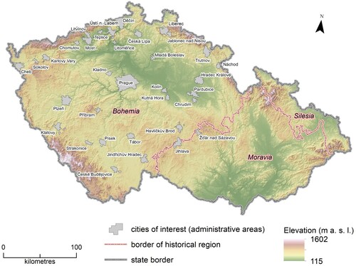
We analyze those Czech cities where the number of inhabitants is over 20,000 (as of 1 January 2018; CitationCzech Statistical Office, 2018) whose administrative area was at least in part of Bohemia. Bohemia is one of the three historical regions of the Czech Republic (). Most ponds and their systems were built in this area in the past; the best known is the South Bohemia Region, where a number of historical ponds have survived until the present day (CitationPokorný & Květ, 2016). Thus, we work with a total set of 34 cities, which meet these conditions including two towns (Jihlava and Žďár nad Sázavou) whose present administrative area intersects with the historical border between the regions of Bohemia and Moravia. As there is a varied range of city definitions and various urban forms within Europe (CitationSchwarz, 2010), we selected the official administrative borders as the spatial city definition. The municipality borders were taken from the latest version of the official geodatabase of administrative borders of the Czech Republic (part of ArcČR500 geodatabase 3.3, from 2016). The area of the former pond Lašitov in the city of Plzeň has been chosen as a case study. It is unique evidence of how a pond, which had originally been located outside the main populated area, became the supportive environment for mining activities to be later swallowed up gradually by growing urban sprawl.
Figure 1. Studied cities in the context of the historical regions of the Czech Republic (data sources: © ArcČR500, ARCDATA Prague, 2016).
2.2. Cartographic sources
Military surveys of the Habsburg Empire, which depict the same areas at a similar scale in different time horizons (CitationSkaloš et al., 2011), serve as the main source of spatial information on former ponds. They proved invaluable in our research of the development of the water component of the landscape combined with GIS in earlier studies (CitationKovács, 2010; CitationPavelková et al., 2016; CitationŠantrůčková et al., 2017). These were specifically:
(1). 1st Military Survey (hereinafter 1MS; from 1763 to 1784; at a scale 1:28,000) depicts the condition of the landscape prior to the onset of industrialization in the Czech lands and prior to the first extensive wave of the destruction of ponds. Regrettably, it was created without geodetic measurements which is evident in its low level of accuracy (CitationHavlíček et al., 2014).
(2). 2nd Military Survey (2MS; 1842–1852; 1:28,800) is a modern geodetically controlled survey of a high level of accuracy relative to its predecessor (CitationPavelková et al., 2016).
The Stabile Cadastre (1826–1843; 1:2800) is used to verify the location of ponds where their identification is hindered by color fading on the 2MS.
The first two sources are accessed through the purchased Web Map Tile Service (WMTS), which emerged within the project Mapire.eu and provides 1MS and 2MS from the Austrian State Archive in a seamless georeferenced layer with a minimum deviation for the entire area of the Habsburg Monarchy (CitationMolnár et al., 2014; CitationTimár et al., 2010). The maps of the Stabile Cadastre were acquired through the State Administration of Land Surveying and Cadastre (ČÚZK) geoportal as the cadastral evidence maps from 1826 to 1956 for the purposes of the case study. WMTS provides access to the current Basic Maps of the Czech Republic (at the scale of 1:5000–1:200,000), the current orthophoto maps, and the Digital Terrain Model of the Czech Republic (5th generation). The Digital Terrain Model is based on data collected using LiDAR airborne techniques and has a standard error of the height 0.18 m in the bare terrain and 0.3 m in the forested terrain (CitationČÚZK, 2019). The Digital Terrain Model (DTM) is available through the WMTS service and through an online geoportal (https://ags.cuzk.cz/dmr/), which allows for various visualizations including the analysis of slopes.
2.3. Methods
A geodatabase of former ponds was created for the 34 selected towns. The first creative phase was based on manual digitizing (in the GIS environment) of former ponds based on old maps. At first, the identified ponds of the more precise 2MS were digitized and were subsequently compared with the ponds of the 1MS. Former ponds were input if they appeared on at least one of the map sources. Those ponds that were submerged beneath reservoirs of the twentieth century have not been included. Having been digitized, the position of the former pond was manually corrected (shifted) so that it corresponded with its position on the current maps (see CitationPavelková et al., 2016). This was necessary, especially in the case of ponds digitized from the 1MS. The possible existence of a relic of a former pond dam was studied using the DTM combined with the current maps and aerial photographs either in the form of an existing dam body in its original height or in various stages of denudation (e.g. in the field). The current land use was then added as an attribute using the modern city plans. The studied attributes are listed in .
Table 1. The studied attributes of former ponds.
3. Results
3.1. Analysis of relics and the uses of areas of former ponds
We identified a total of 1060 former ponds, with a prevailing size of up to 3 ha in the studied cities. Out of this number, we succeeded in finding 437 (41.2%) potential dam relics using the DTM ((a)). The total length of relict dam structures is nearly 60 km. The largest share in the length of these former structures are those serving as embankments for transport infrastructure (56.4%), especially as roads (29.4%) and trails (24.6%). A large number of preserved dam earthworks can be found inside built-up areas of a city or in its near vicinity (53.3%) ((b)).
Figure 2. Main results from analysis of former ponds in the 34 city administrative areas.
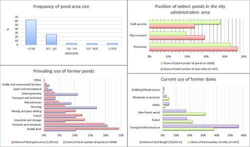
Regarding the prevailing use of former pond water areas (the total of 2293 ha), agricultural land dominates the with 43.9% in the vicinity of cities or in the more distant rural areas ((c)). A number of dam earthworks are still preserved there (38% from the total number of all recorded dams). A great number of relics are in urban woods which cover 12.3% of the area of the studied former ponds and 82% of these ponds still have preserved dam relics ((d)).
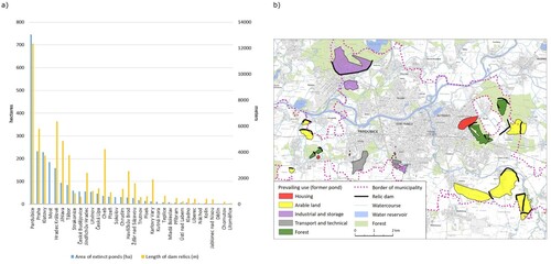
Some 32% (740 ha) of the total area of former ponds lie within the city of Pardubice together with more than 12 km (21% of the total length) of dam structures ((a)). Place names referring to ponds were found in nearly 5% of the cases. These were both street names and the names of local parts in the urban built-up areas and minor names (or field names) in the rural areas.
Figure 3. Former pond areas and length of dam relics: (a) Summary for studied cities; (b) City of Pardubice – position of former ponds from the old maps and former dams visible on the DTM (data source: © ČÚZK).
3.2. Case study: the former pond Lašitov
The anthropogenic impact on sites of former ponds reflects the historical changes in the land use of the suburban landscape. This is exemplified by the former pond at Lašitov to the south-west of Plzeň. The changes documented by the research are connected with the growth and development of buildings in the cadastral area of the Valcha satellite settlement. Valcha, which is now part of the district Plzeň 3, has 1097 permanent residents (as of 1 January 2019) – the number continues to grow, as do new residential buildings. A significant part of the Valcha building development also consists of buildings of the second housing, which were built there from the 1870s in connection with the suburban recreational reservoir on the Radbuza river. The Lašitov pond was part of the pond system of the monastery in Chotěšov founded in the Luční potok (Meadow Creek) basin during the fourteenth century. The Lašitov pond, also recorded in the 2MS as ‘Radschiner Teich,’ had an area of 51 ha according to this source. The distinctly elongated shape of the pond followed the shape and direction of the shallow valley. Waterpower was used to drive the mill and the cloth mill under the dam, which was built in the narrowed section of the valley.
The Lašitov pond was drained in 1851 as a result of new underground mining activity of hard coal. The land was to be returned later in a condition capable of re-irrigation according to contracts (CitationHataj, 1926). However, the ponds were never restored. The Stabile Cadastre map still shows the area of the pond although the banks begin to show the first visible buildings of the beginnings of mining activity. At first, the coal seams were opened at random, using primitive subsurface mines reaching the depth of only about 30–40 m. Mining modernization and ongoing exploration allowed for the development of mining in the adjacent area west of the Lašitov pond where the mines were in operation until 1921 (CitationKopp et al., 2015). Therefore, the west part of the pond basin was partly covered up with mining dumps which are currently overgrown with forest. The modern settlement of Valcha was established as a mining colony in 1872 with a population of up to 1100 inhabitants. The next development phase began in the 1920s at the initiative of the city of Plzeň. However, the territorial structure of this settlement is still fundamentally influenced by the muddy lands of the former pond, which unnaturally fill the center of the urban unit. The bottom of the pond as a natural area of water and wetland vegetation has partially grown over with natural seeding of bushes and trees. As regards to the anthropogenic use, the elongated wetland area creates a barrier against movement of persons and significantly limits the expansion of construction in the center of Valcha. The main communication which connects the separate parts leads to a larger part along the former dam. A new housing development is gradually being built on the dam as well as the edges of the pond area. In the twentieth century, the areas raised above its original bottom were gradually expanded with backfilling, especially along the former left bank of the pond. New estates with gardens were created on the landfill (terrace) which were changed in the twenty-first century into residential areas under the pressure of the suburbanization processes of the Plzeň agglomeration. It is probable that the next stage of development will include more backfilling and the gradual change of the pond area into building plots. These processes cause the loss of the significance of the pond area as a local biocentre and an area of a natural water retention. A detailed study of relief changes of the pond area is provided in the Main Map.
4. Discussion
4.1. Discussion of the results
The results show ((a)) that the surviving remains of ponds with their associated dam earthworks are found mainly in cities with larger administrative areas that include outlying villages, such as the cities of Prague and Klatovy. Large numbers are also found in the fish farming areas of South Bohemia (Tábor, České Budějovice) and East Bohemia along the Elbe (CitationLochmann, 1970). As already noted above, a large number of former ponds and their associated dam earthworks are evident in the city of Pardubice. Some of these ponds are of several hundred hectares. For example, the Semtín pond had an area of 185 ha according to the 1MS and was surrounded by a circular dam. Its relic of over 2.8 kms is, to this day, preserved as a road running on top of it which fringes the chemical plant built on the area of the former pond.
From the point of view of the current use of relics of dams, our results are consistent with the studies of CitationDavid and Černochová (2020) in the Blanice river catchment (Czech Republic), where the identified preserved dams of former ponds often serve as paved or unpaved roads. The transport function of pond dams has a historical tradition ((a)). It is apparent from old maps that pond dams were used as communication links over common wetlands of floodplains. The sixteenth century European pond literature, represented by Janis Dubravius, Olbrycht Strumieński, and Petrus Magni (CitationSvanberg & Cios, 2014), demonstrates that great attention was paid to the principle of pond construction and especially the construction of dams. Dam foundations were to be based deep enough to avoid their underpinning and collapse. The local soil was laid in layers on the dam and was thoroughly rammed down. The inflow and air side of the dam was often reinforced with grass, stones or wood (CitationPavelková et al., 2014). A dam built in this manner with a functional communication was often preserved. However, the presented case study shows that in the cases of important roads, the body of the dam was rebuilt and adjusted according to the required transport standards. We can assume that the material of the original dam was used in the new embankment. CitationŽatecký (2015) also mentioned in this respect problems of safety with current ponds whose dams often have roads, which were not designed to carry the current heavy traffic, and increased transport intensity. A number of dam relics are preserved in the woods which function as forest roads in the wetlands or are the remnants of former anthropogenic activities ((c)). This confirms the conclusions of archaeologists who consider the forest as one of the best conservationists when examining the history of a settlement. The role of dam relics is interesting in suburban agriculturally intensely utilized landscapes with preserved dams as common sanctuaries of non-forest woody vegetation (CitationDemková & Lipský, 2015). Our results show that 32% of the total number for recorded dam relics and 17% of their length serve as sanctuaries for non-forest woody elements ((b)).
Figure 4. Examples of relics of the dam in city administrative areas: (a) Relic of a massive dam of the former pond Točník which is used as a road embankment (city: Klatovy; old map: 1MS); (b) Half of the former dam of the pond covered by non-forest woody vegetation (city: Písek; old map: 2MS); (c) Relics of dams in the woods near the city Jihlava (old map: 1MS). Source: © ČÚZK; © Austrian State Archives [Österreichisches Staatsarchiv] – all rights reserved (survey, z.B. ‘Josephinische Landesaufnahme’ / ‘First military survey’), Mapire.eu; © Czech National Geoportal (CENIA).
![Figure 4. Examples of relics of the dam in city administrative areas: (a) Relic of a massive dam of the former pond Točník which is used as a road embankment (city: Klatovy; old map: 1MS); (b) Half of the former dam of the pond covered by non-forest woody vegetation (city: Písek; old map: 2MS); (c) Relics of dams in the woods near the city Jihlava (old map: 1MS). Source: © ČÚZK; © Austrian State Archives [Österreichisches Staatsarchiv] – all rights reserved (survey, z.B. ‘Josephinische Landesaufnahme’ / ‘First military survey’), Mapire.eu; © Czech National Geoportal (CENIA).](/cms/asset/230f4a9c-64ab-4c7e-8fac-3ca31f80d4f6/tjom_a_1819900_f0004_oc.jpg)
Within the intangible imprint of former ponds, we can mention 50 place names referring to former ponds which we managed to capture within our research. These are mainly as street or field names. Moreover, many of these streets copy the shape of the original pond dam ((a)) thus connecting the imaginary terrain as well as the written reference to this former historical landscape element (CitationFrajer & Fiedor, 2018). A special case is again registered in the city of Pardubice, which lost the municipality of Spojil in 1991 when the village became independent and now forms an enclave in the city of Pardubice. The name of the village refers to the pond of Spojil from which the village was built on at the end of the eighteenth century. The cadastral territory of the village roughly follows the borders of the former pond ((b)).
Figure 5. Place names connected with former ponds in urban landscape: (a) Street Rybniční (Pond street) which refers to one of the former ponds and copies the original pond dam (city: České Budějovice); (b) Enclave of the village Spojil in the administration area of the city of Pardubice, which was built on the bottom of the pond of the same name Spojil. Source: © OpenStreetMap; © Austrian State Archives [Österreichisches Staatsarchiv] – all rights reserved (survey, z.B. ‘Josephinische Landesaufnahme’ / ‘First military survey’), Mapire.eu; © Czech National Geoportal (CENIA).
![Figure 5. Place names connected with former ponds in urban landscape: (a) Street Rybniční (Pond street) which refers to one of the former ponds and copies the original pond dam (city: České Budějovice); (b) Enclave of the village Spojil in the administration area of the city of Pardubice, which was built on the bottom of the pond of the same name Spojil. Source: © OpenStreetMap; © Austrian State Archives [Österreichisches Staatsarchiv] – all rights reserved (survey, z.B. ‘Josephinische Landesaufnahme’ / ‘First military survey’), Mapire.eu; © Czech National Geoportal (CENIA).](/cms/asset/5925182c-3040-4231-887d-13d23ca23551/tjom_a_1819900_f0005_oc.jpg)
4.2. Discussion of the methods
It is necessary to expect certain limitations and obstacles when working with historical sources of information. This mostly concerns the inaccuracies in the cartographic processing (CitationHavlíček et al., 2014) as well as the contents which reflected the historical form of the landscape. The 1MS is especially questionable in this respect as the positional errors are significant, amounting to hundreds of meters (CitationZimová et al., 2006). Although the positional error in the applied mosaic of georeferenced maps reached 200 m at a maximum (CitationMolnár et al., 2014), it must be taken into consideration. Thus, the areas of depicted ponds may be distorted, as the mapping officer could not draw accurately without the geodetic tools and geodeticly controlled reference system. This also applies to situations where the officer may have overestimated or underestimated the area of the pond. This situation can be revealed when we compare the pond area recorded on the old map with relics of dam on the current DTM or in the field. An example of this discrepancy is shown on the Main Map (part D). If retrogressive methods of reconstruction are applied in this case (CitationFrajer et al., 2013), the later and more accurate 2MS will show that the original location of a former pond is covered by a vast wet meadow. Thus, it is probable that the pond used to cover a large area of it. However, it is impossible to make an accurate reconstrucition of the shape of the meadow through the course of the shoreline of the pond, which is apparent following the course of the current contour lines (a possible shoreline of pond), which do not copy the outline of the meadow ().
Figure 6. Uncertainty about the reconstruction of water area of pond: red line – pond water area according to 1MS; yellow line – wet meadow according to 2MS; white lines – contours Data source: © Austrian State Archives [Österreichisches Staatsarchiv] – all rights reserved (survey, z.B. ‘Josephinische Landesaufnahme’ / ‘First military survey’), Mapire.eu; ; © Czech National Geoportal (CENIA); © ZABAGED; ČÚZK.
![Figure 6. Uncertainty about the reconstruction of water area of pond: red line – pond water area according to 1MS; yellow line – wet meadow according to 2MS; white lines – contours Data source: © Austrian State Archives [Österreichisches Staatsarchiv] – all rights reserved (survey, z.B. ‘Josephinische Landesaufnahme’ / ‘First military survey’), Mapire.eu; ; © Czech National Geoportal (CENIA); © ZABAGED; ČÚZK.](/cms/asset/e795eafa-af09-4257-a907-474d1db0fc7d/tjom_a_1819900_f0006_oc.jpg)
The question remains with what precision were the ponds captured on the old maps, especially in areas with a large number of smaller ponds. The initial assumption that the number of plotted ponds will reflect the real state of the landscape at that time (as these were militarily strategic landscape elements) was not fulfilled in some areas. This fact was highlighted by the larger number of ponds plotted in the 2MS than in the same area in the 1MS ((a)). Previous studies that fully utilized 1MS (e.g. CitationSkaloš et al., 2011) worked with a limited number of map sheets, where the style of displaying and rendering of ponds had not changed. However, we encounter this phenomenon when working with a larger number of sheets, which hinders the interpretation ((b)). This brings us to another limit of the study. The interpretation of maps and the comparison of data sources were done manually. With a large number of plotted objects and creation of the database it is possible that some facts may have been overlooked or omitted. In our case, the interpretation of the plotted ponds in historical maps and their correct placement in current maps was combined with the recognition of dam relics on the current DTM, which can be distorted in some cases by later anthropogenic changes and interventions. These changes cannot be discovered without knowledge of detailed historical context and field survey (see case study). The field survey can also reveal misinterpretations from the DTM, especially in the case of small or very low dam relics. Our study focuses on the prevailing use of former ponds and their dams, but we must consider that sometimes their use is mixed.
Figure 7. Limits of the old maps: (a) Different numbers of ponds and their depiction between two map sources (city: Jindřichův Hradec); (b) Different styles of displaying ponds on the map sheets of 1MS. Source: © Austrian State Archives [Österreichisches Staatsarchiv] – all rights reserved (survey, z.B. ‘Josephinische Landesaufnahme’ / ‘First military survey’), Mapire.eu; ; © Czech National Geoportal (CENIA).
![Figure 7. Limits of the old maps: (a) Different numbers of ponds and their depiction between two map sources (city: Jindřichův Hradec); (b) Different styles of displaying ponds on the map sheets of 1MS. Source: © Austrian State Archives [Österreichisches Staatsarchiv] – all rights reserved (survey, z.B. ‘Josephinische Landesaufnahme’ / ‘First military survey’), Mapire.eu; ; © Czech National Geoportal (CENIA).](/cms/asset/813353d7-24f7-42e8-acd6-b1135a561cca/tjom_a_1819900_f0007_oc.jpg)
Despite the above-mentioned limitations, working especially with the 1MS was truly beneficial as the locations of 465 ponds were identified (44% of the total set) which were not plotted in the 2MS, not even in the form of dam relic.
5. Conclusions
The cities, which expanded into their adjacent landscapes during the 19th and especially 20th centuries, gradually absorbed the individual elements of the historical landscape and transformed them to their own image. The same fate occurred to many man-made ponds in the landscape of the Czech Republic. Some ponds served as sources of water or energy in the early stages of city development, while others were used in commercial fish farming. Most of them became former during the nineteenth century for various reasons and their former areas are covered now with residential areas or city greenery. In the immediate vicinity of the city, these former ponds mostly serve as agricultural land or forests. However, the relics of such ponds are found in the form of at least partially preserved dams and are still apparent in the digital terrain model. They were most commonly used as foundations for street or roads networks which is reflected in some place names, especially street names. The study of dam relics in urban environments represent another challenge of geomorphological and geographical research. At present, small water reservoirs and their potential renewal in the Czech Republic are a widely discussed topic in connection with the possibilities of coping with recurrent drought episodes (CitationFrajer & Fiedor, 2018), which could relate to former ponds in the open countryside around the city.
Software
The digitization of ponds, the follow-up analyses and the creation of the resulting map were made in the program ArcMap (ver. 10.7) by ESRI. Recognition of the relics of ponds was made with the help of online Geoportal ČÚZK (https://ags.cuzk.cz/dmr/).
Main Map.pdf
Download PDF (19.9 MB)Acknowledgements
The authors would like to express their thanks to all reviewers for their valuable remarks and recommendations.
Disclosure statement
No potential conflict of interest was reported by the author(s).
Additional information
Funding
References
- Bartolini, N. (2014). Critical urban heritage: From palimpsest to brecciation. International Journal of Heritage Studies, 20(5), 519–533. https://doi.org/10.1080/13527258.2013.794855
- Brown, R. R., Keath, N., & Wong, T. H. F. (2009). Urban water management in cities: Historical, current and future regimes. Water Science and Technology, 59(5), 847–855. https://doi.org/10.2166/wst.2009.029
- Burgin, S., Franklin, M. J. M., & Hull, L. (2016). Wetland loss in the transition to urbanisation: A case study from Western Sydney, Australia. Wetlands. https://doi.org/10.1007/s13157-016-0813-0
- Czech Statistical Office (ČSÚ). (2018). Cities with population 20,000 and more as of 1st January 2018. https://www.czso.cz/documents/10180/61601876/32019918100.pdf/1e975b12-fbd6-4f98-8c25-f0168b7415ca?version=1.0
- ČÚZK. (2019). Digital Terrain Model of the Czech Republic of the 5th generation (DMR 5G) [cit. 21.07.2019]. Czech Office for Surveying, Mapping and Cadastre. https://geoportal.cuzk.cz/(S(pnr04rq0u13a5iikemqyedoo))/Default.aspx?lng=EN&mode=TextMeta&side=vyskopis&metadataID=CZ-CUZK-DMR5G-V&mapid=8&menu=302
- David, V., & Černochová, K. (2020). Identification of ponds in the Blanice catchment area on maps of 1st Austrian Military Survey [in Czech]. Water Management Technical and Economical Information Journal (VTEI Journal), 1, 32–37. https://www.vtei.cz/2020/02/identifikace-rybniku-v-povodi-blanice-na-mapach-i-rakouskeho-vojenskeho-mapovani/
- Demková, K., & Lipský, Z. (2015). Changes in non-forest woody vegetation in the south-western part of the White Carpathians (1949–2011). Geografie, 120(1), 64–83. https://doi.org/10.37040/geografie2015120010064
- Doyle, M. W., Harbor, J. M., Rich, C. F., & Spacie, A. (2000). Examining the effects of urbanization on streams using indicators of geomorphic stability. Physical Geography, 21(2), 155–181. https://doi.org/10.1080/02723646.2000.10642704
- Frajer, J. (2019). Josephian cadastre as a source of geographic information on historical landscapes. Geografie, 124(3), 315–339. https://doi.org/10.37040/geografie2019124030315
- Frajer, J., & Fiedor, D. (2018). Discovering extinct water bodies in the landscape of Central Europe using toponymic GIS. Moravian Geographical Reports, 26(2), 121–134. https://doi.org/10.2478/mgr-2018-0010
- Frajer, J., Kladivo, P., & Geletič, J. (2013). Reconstruction of extinct ponds using old maps, historical cadastres and the Digital Terrain Model of the Czech Republic of the 5th Generation. Acta Universitatis Palackianae Olomucensis – Geographica, 44(1), 59–69. https://geography.upol.cz/soubory/vyzkum/aupo/Acta-44-1/AUPO_Geographica_44-1_Frajer_et-al_RGB.pdf
- Gregory, K. J. (2006). The human role in changing river channels. Geomorphology, 79(3–4), 172–191. https://doi.org/10.1016/j.geomorph.2006.06.018
- Hanušin, J. (1995). The analysis of the impact of urban landscape on hydrologic cycle of the area. Geografický časopis, 47(4), 275–284.
- Hataj, V. (1926). Rybníky na bývalém panství chotěšovském [in Czech]. Plzeňsko – list pro vlastivědu západních Čech, 5, 84–87.
- Havlíček, M., Pavelková, R., Frajer, J., & Skokanová, H. (2014). The long-term development of water bodies in the context of land use: The case of the Kyjovka and Trkmanka River Basins (Czech Republic). Moravian Geographical Reports, 22(4), 39–50. https://doi.org/10.1515/mgr-2014-0022
- Johnson, P. M. (2001). Environmental impacts of urban sprawl: A survey of the literature and proposed research agenda. Environment and Planning A: Economy and Space, 33(4), 717–735. https://doi.org/10.1068/a3327
- Kasanko, M., Barredo, I. J., Lavalle, C., McCormick, N., Demicheli, L., Sagris, V., & Brezger, A. (2006). Are European cities becoming dispersed? A comparative analysis of 15 European urban areas. Landscape and Urban Planning, 77(1–2), 111–130. https://doi.org/10.1016/j.landurbplan.2005.02.003
- Kopp, J., Frajer, J., & Pavelková Chmelová, R. (2015). Driving forces of the development of suburban landscape – a case study of the Sulkov site west of Pilsen. Quaestiones Geographicae, 34(3), 51–64. https://doi.org/10.1515/quageo-2015-0028
- Kovács, G. (2010). The advantages of using the second military survey maps in fluvial studies. Acta Geodaetica et Geophysica Hungarica, 45(1), 64–70. https://doi.org/10.1556/AGeod.45.2010.1.10
- Lentacker, A., Van Neer, W., & Plumier, J. (1997). Historical and archaeozoological data on water management and fishing during medieval and post-medieval times at Namur (Belgium). In G. De Boe, & F. Verhaeghe (Eds.), Environment and subsistence in medieval Europe. Papers of the “medieval Europe Brugge 1997” Conference (vol. 9, pp. 83–94). Instituut voor het Archeologisch Patrimonium.
- Lochmann, Z. (1970). The Opatovice channel and its historico-geographical development. Sborník Československé společnosti zeměpisné, 75(3), 219–233.
- Mitra, D., & Banerji, S. (2018). Urbanisation and changing waterscapes: A case study of New Town, Kolkata, west Bengal, India. Applied Geography, 97, 109–118. https://doi.org/10.1016/j.apgeog.2018.04.012
- Molnár, G., Timár, G., & Biszak, E. (2014). Can the First Military Survey maps of the Habsburg Empire (1763–1790) be georeferenced by an accuracy of 200 meters? https://www.arcanum.hu/media/uploads/mapire/pub/1survey_molnar_et_al.pdf, https://doi.org/10.13140/2.1.1447.8724
- Pavelková, R., Frajer, J., Havlíček, M., Netopil, P., Rozkošný, M., David, V., Dzuráková, M., & Šarapatka, B. (2016). Historical ponds of the Czech Republic: An example of the interpretation of historic maps. Journal of Maps, 12(Suppl. 1), 551–559. https://doi.org/10.1080/17445647.2016.1203830
- Pavelková, R., Frajer, J., & Netopil, P. (2014). Historické rybníky České republiky. Srovnání současnosti se stavem v 2. polovině 19. století [ Historic ponds in the Czech Republic: comparison of the current situation with the condition of the second half of the 19th century]. T. G. Masaryk Water Research Institute.
- Pesaresi, M., Melchiorri, M., Siragusa, A., & Kemper, T. (2016). Atlas of the human planet 2016. Mapping human presence on earth with the global human settlement layer. Publications Office of the European Union. https://doi.org/10.2788/889483
- Pokorný, J., & Květ, J. (2016). Fishponds of the Czech Republic. In C. M. Finlayson, G. R. Milton, R. C. Prentice, & N. C. Davidson (Eds.), The wetland book (pp. 1–17). Springer. https://doi.org/10.1007/978-94-007-6173-5_208-2
- Schwarz, N. (2010). Urban form revisited—selecting indicators for characterising European cities. Landscape and Urban Planning, 96(1), 29–47. https://doi.org/10.1016/j.landurbplan.2010.01.007
- Skaloš, J., Weber, M., Lipský, Z., Trpáková, I., Šantrůčková, M., Uhlířová, L., & Kukla, P. (2011). Using old military survey maps and orthophotograph maps to analyse long-term land cover changes – Case study (Czech Republic). Applied Geography, 31(2), 426–438. https://doi.org/10.1016/j.apgeog.2010.10.004
- Svanberg, I., & Cios, S. (2014). Petrus Magni and the history of fresh-water aquaculture in the later Middle Ages. Archives of Natural History, 41(1), 124–130. https://doi.org/10.3366/anh.2014.0215
- Szabó, J. (2010). Anthropogenic geomorphology: Subject and system. In J. Szabó, L. Dávid, & D. Lózcy (Eds.), Anthropogenic geomorphology. A guide to man-made landforms (pp. 3–13). Springer.
- Šantrůčková, M., Demková, K., Weber, M., Lipský, Z., & Dostálek, J. (2017). Long term changes in water areas and wetlands in an intensively farmed landscape: A case study from the Czech Republic. European Countryside, 9(1), 132–144. https://doi.org/10.1515/euco-2017-0008
- Timár, G., Biszak, S., Székely, B., & Molnár, G. (2010). Digitized maps of the Habsburg military surveys – overview of the project of ARCANUM Ltd. (Hungary). In M. Jobst (Ed.), Preservation in digital cartography (pp. 273–283). Springer.
- Winiwarter, V., Haidvogl, G., Hohensinner, S., Hauer, F., & Bürkner, M. (2016). The long-term evolution of urban waters and their nineteenth century transformation in European cities. A comparative environmental history. Water History, 8(3), 209–233. https://doi.org/10.1007/s12685-016-0172-z
- Zimová, R., Pešťák, J., & Veverka, B. (2006). Historical military mapping of Czech lands –positional accuracy of old maps. GIM International, 20(10), 21–23.
- Žatecký, S. (2015). Ponds – Actual issues of their building and maintenance. In V. David & T. Davidová (Eds.), Rybníky – naše dědictví i bohatství pro budoucnost [Conference Proceedings in Czech] (pp. 176–187). Czech Technical University in Prague.