
ABSTRACT
The 2019 Geomorphological Field Camp at San Domino Island (Tremiti Islands, Southern Adriatic Sea) is the result of geological and geomorphological field work activities carried out by a group of students attending the Geomorphological field mapping course of the Master’s Degree in Geological Science and Technology (University of Chieti-Pescara). The main map (1:5000 scale) was obtained through an integrated approach that incorporates morphometric analysis, geological and geomorphological field mapping, and geomorphological profiles drawing. Activities were carried out by all students, divided into six working groups of three to four persons each. The field camp and field work activities made it possible to produce a detailed thematic map, as a scientific tool to depict the San Domino Island landscape, and to outline some geomorphological issues in terms of possible constraints to landscape evolution, geomorphological processes distribution, and natural hazard assessment.
1. Introduction
Geomorphological mapping can be a helpful tool for the interpretation of landforms at almost any spatial scale (CitationDykes, 2008). Geomorphological maps can be considered graphical inventories of a landscape, depicting landforms and surfaces, as well as subsurface features. Sketches and maps have been fundamental methods to analyze and visualize landscape features ever since early geomorphological research (CitationVerstappen, 2011). The widespread distribution and extended graphical capabilities of Geographic Information Systems (GIS), as well as the availability of high-resolution remote sensing data and Digital Elevation Models (DEMs), has led to the recent rejuvenation of the methodologies of mapping. Geomorphological maps can act as a scientific tool for land management and geological-geomorphological risk management, as well as providing baseline data for other applied sectors of environmental research and studies (CitationBozzano et al., 2020; CitationCarabella et al., 2019; CitationLee, 2001; CitationMelelli et al., 2012; CitationOtto & Smith, 2013; CitationReddy, 2018). These thematic maps may either focus on selected landscape features, for example only depicting the morphology of active processes, or deliver a full view on the landscape composition and its evolution (CitationDramis et al., 2011; CitationKnight et al., 2011; CitationVerstappen, 2011). However, teaching how to map the geomorphology of an area cannot be performed in a satisfying manner only in the lecture room but requires practical exercises in the field (Citationde Waele et al., 2012). This paper is the result of a field mapping campaign carried out at Tremiti Islands (Puglia Region, Southern Adriatic Sea), by a group of students attending the Geomorphological field mapping course held as part of the Master’s Degree in Geological Science and Technology at University of Chieti-Pescara. Geological and geomorphological field work activities have strengthened the awareness of the power of field observations, surveys, and mapping for the understanding of natural processes at different spatial and temporal scales: from the long-term landscape evolution to the short-term development of a landslide or coastal retreat inducing geomorphological hazards. This has encouraged constant efforts in teaching field work activities to young geologists, trying to combine contemporary hardware and software tools provided by technological advancements with traditional field methods (CitationMiccadei et al., 2016). The Geomorphological Field Camp was held on September 30 – October 4, 2019, at San Domino Island (Tremiti Islands). The study area was chosen because of its peculiar geomorphological features, linked to landslide processes and coastal erosion, which are the expression of a complex and long-term landscape evolution. For these reasons, the Tremiti Islands can be considered a significant laboratory for geological and geomorphological studies, showing an outstanding wealth of ancient and present terrestrial and marine landforms. The islands are characterized by landforms originated from marine and continental geomorphological processes, such as gravitational, fluvial, and karst processes (CitationMiccadei, Mascioli, and Piacentini, 2011). These landforms preserve the record of a long Quaternary landscape evolution driven by the dynamic interaction between climate, tectonics, and sea-level changes (CitationMastronuzzi & Sansò, 2002; CitationMiccadei, Mascioli, Orrù, et al., 2011). Finally, the main purpose of this paper was to outline the fundamental role of field work in the analysis of the landscape and land management. The overall field activities enhanced the crucial role of field-based learning for young geomorphologists that allows them to acquire a strong sensitivity, describing the main geomorphological issues in terms of possible constraints to landscape evolution, geomorphological processes distribution, and natural hazard assessment.
2. Study area
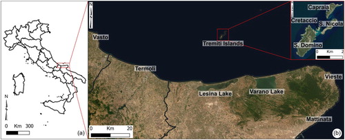
The Tremiti Islands are located in the central-southern Adriatic Sea, about 20 km offshore of the Gargano coast (). They include San Domino, San Nicola, Capraia, and Cretaccio islands; Pianosa island also belongs to the archipelago, but is located about 17 km away from the main islands towards NE. The overall morphology rises from a gentle underwater slope, that ranges between 50 and 70 m b.s.l., reaching the maximum altitude (>110 m a.s.l.) at San Domino Island. The archipelago is characterized by a Cenozoic marine sedimentary succession, made up of calcareous, dolomitic, and marly-calcareous rocks. This succession is overlain by a Quaternary continental succession, composed of different units (breccias, conglomerates, and sandy deposits) belonging to slope, fluvial, and aeolian depositional environments. It also includes eluvial-colluvial deposits and soils (CitationMiccadei, Mascioli, & Piacentini, 2011; CitationSelli, 1971). The tectonic setting is linked to the presence of main fault systems, showing E-W, WSW-ENE and NE-SW directions; they are characterized by strike-slip kinematics and by strong seismicity, as confirmed in the neighboring Gargano area, with earthquakes along E-W to SW-NE tectonic discontinuities, associated with strike-slip and transpressive focal mechanism and magnitude up to 4.0 (CitationArgnani et al., 1993; CitationDe Alteriis, 1995; CitationDel Gaudio et al., 2007; CitationDi Bucci et al., 2007; CitationFavali et al., 1993; CitationISIDe Working Group, 2007; CitationRovida et al., 2019). The geomorphological features of the archipelago are the superficial expression of Quaternary tectonics, regional uplift, and eustatic sea-level changes (CitationParlagreco et al., 2011; CitationRidente & Trincardi, 2002). The landscape is characterized by landforms due to gravitational, fluvial, karst, coastal and marine processes which outline a complex long-term evolution resulting from the superimposition of marine, coastal, and subaerial processes. In detail, the present-day morphodynamics of the islands is characterized by the complex interaction of gravitational and marine processes that induce the instability of marine cliffs (CitationMiccadei et al., 2012).
Figure 1. (a) Location map of the study area in Southern Italy; (b) satellite image of Gargano promontory’s coast (ESRI Satellite, World Imagery). In the red zoomed box, there is the orthophoto image of the Tremiti Islands (Puglia Region, http://www.sit.puglia.it).
3. Methods
The geomorphological analysis of San Domino Island was based on an integrated approach that incorporates morphometric analysis, geological and geomorphological field mapping, and geomorphological profiles drawing. Activities were carried out by all students, divided into six working groups () of three to four persons each. The mapping procedure included three main stages: (i) pre-field camp (pre-mapping) preparatory steps to describe the geological-geomorphological setting of the area and to identify the field mapping protocol to be used, (ii) the field work (during the five-day mapping campaign) to observe and map geomorphological features, focusing on the solution of a specific geomorphological issue, and (iii) post field camp activities (post-mapping) to recognize landscape features, identify geohazards, and draw the final geomorphological map, using GIS software.
Table 1. Specific geomorphological issues for each working group.
The Main Map presented in this paper includes three main sections:
Morphometry section (in the upper right part);
Main geomorphological map section (in the central part);
Geomorphological issues section (in the lower part).
Vector topographic data (1:5000 scale) were retrieved from the Cartographic office of Puglia Region (http://www.sit.puglia.it). The morphometric analysis, as well as the mapping, was carried out with the GIS software (QGIS 2019, version 3.10 “A Coruña” and ArcMap® 10.6). It involved the analyses of the main orographic features such as elevation, slope, aspect (CitationStrahler, 1952) and local relief (sensu CitationAhnert, 1984, elevation range in a 500 m2 window). These primary DEM attributes were extracted from LiDAR data (1 m resolution), provided by Ministero dell’Ambiente e della Tutela del Territorio e del Mare (http://www.minambiente.it/). Geological and geomorphological analyses were based on field work activities integrated with orthophoto interpretation. In this process, each of the six groups was assigned a specific geomorphological issue () and a field survey area of about 1 km2 (see red boxes on the Main Map).
Field mapping was carried out at the 1:3000 scale to investigate the outcropping bedrock lithology, tectonic features, superficial deposits, and the distribution of structural, gravitational, karst, marine, fluvial and anthropogenic landforms, using a common legend. Mapping was performed according to the guidelines of the Geological Survey of Italy and AIGeo (Italian Association of Physical Geography and Geomorphology) (CitationISPRA, 2007; CitationISPRA & AIGEO, 2018) and was also in accordance with the literature concerning geomorphological mapping (e.g. CitationCalista et al., 2016; CitationGNGFG, 1994; CitationMiccadei et al., 2012; CitationOtto et al., 2011; CitationSmith et al., 2011). After the field work, each group presented a 1:5000 preliminary map of the field survey area, geomorphological cross-sections, photo documentation, and a discussion of the specific assigned issue. The individual maps were checked, summarized and then assembled to form a unique geomorphological map.
4. Results
The enclosed map shows the main features of the area and is made up of three sections, described in the following paragraphs.
4.1. Morphometry
A morphometric analysis of the Tremiti Islands was carried out as a part of the preliminary activities and allowed to outline the main landscape features of the area to be verified and mapped by means the geomorphological field work.
The study area reaches its maximum altitude (>110 m a.s.l.) in correspondence of the tabular summit of San Domino Island. Other islands show moderate altitude that reaches ∼80 m a.s.l., at San Nicola Island and ∼60 m a.s.l., at Capraia Island. The area shows a rather homogeneous aspect exposure distribution, with northwest and west exposed slopes most frequent than the south and southeast ones, especially at San Domino. The local relief distribution ranges from 40 to 120 m, with the highest values (between ∼140 and >160) located in the SW sector of San Domino and the northernmost sector of Capraia. San Domino is characterized by a slightly rugged morphology, with elevation ranging from 11 to 110 m a.s.l., bordered by cliffs. It shows a homogeneous slope distribution (values between 2° and 10°) with the highest values (>30°) along the cliffs. San Nicola shows a tabular morphology with an elevation around 70 m a.s.l. Slope values range from ≤2 ° to 5° on the summit tabular surface with high values (>30°) along the surrounding sub-vertical cliffs. Capraia shows an irregular morphology with elevation ranging from 11 to 50 m a.s.l. and a homogeneous slope distribution (values between 2° and 15°) with the highest values (> 30°) in the northernmost sector.
4.2. Main geomorphological map
On the Main map, the following lithological and geomorphological elements are included.
Lithologies are subdivided into calcareous bedrock and superficial deposits.
Bedrock units are represented by dolomitic limestone, nummulitic limestone, and calcarenitic limestone and marls, stratified or in massive setting, pertaining to a Paleogene-Pliocene marine succession. In detail, dolomitic limestone mainly outcrops in the southernmost sector of the island between Grotta delle Viole and Punta Secca. Nummulitic limestone widely outcrops along the north-western coastline and calcarenitic limestone and marls are widespread along the cliffs between Cala Matano and Molo di San Domino. Cataclastic rocks, representing the backbone of vertical cliffs at I Pagliai, were also classified as bedrock units.
Superficial deposits are represented by deposits related to slope, fluvial, aeolian, and karst depositional environments, mainly pertaining to a Pleistocene-Holocene continental succession; specifically, breccias, calcretes, aeolian sands, eluvium-colluvium deposits, soils, and landslide deposits were identified. These deposits are generally exposed from sea-level up to the summit of San Domino island, more than 100 m a.s.l., with a maximum thickness of about 40 m. Eluvium-colluvium and soil deposits are largely widespread in the inner areas consisting of argillaceous and dark reddish-brown deposits (CitationMiccadei et al., 2012).
The geomorphological features of the study area are classified according to their morphogenetic processes in structural, gravitational, karst, marine, fluvial, and anthropic landforms. A specific focus was devoted to these elements. They are widely described in the following paragraph to highlight their role played in the main geomorphological issues. Moreover, their arrangement is summarized in the geomorphological cross-sections (see Group boxes on the Main Map), which graphically shows their spatial distribution on the island.
4.3. Geomorphological issues
The combination of preliminary activities, detailed field work activities, and drawing and analysis of geomorphological cross-sections allowed each working group to analyze and discuss the specific geomorphological issue assigned.
4.3.1. Site selection for a new nautical-touristic port
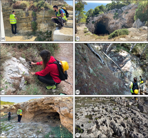
The field survey area (see Group 1 box on the Main Map) is in the northernmost sector of San Domino island and it covers the area of Molo di San Domino, where is currently located the nautical-touristic port. In order to outline the available criteria to expand the port’s area or to select sites for a new port, specific and detailed geological and geomorphological field investigations ((a)) were performed. Gravitational landforms are represented by landslide deposits with associated landslide scarps. These deposits refer to rockfalls and topple and consist of small- to medium-size calcareous blocks located especially at the base of the cliffs at I Pagliai. Local processes related to viscous deformation of shallow material (creep and/or solifluction) affect the slopes or portions of slopes surrounding the port’s area, where the eluvial-colluvial cover is thicker, and the erosive action of running waters is greater. Karst landforms are represented by sub-circular dolines (5–10-m wide), partially filled by superficial deposits, at heights ranging from 30 to 40 m a.s.l. and doline edges along the eastern coast. Caves, partly or completely submerged by seawater, are also present. Coastal landforms are represented by a cliff edge, continually extended along the coastline showing an NW-SE direction and by stacks and emerged rocks in the marine area. Finally, anthropic landforms are widespread throughout the area, mainly represented by anthropic surfaces and scarps. The main geomorphological hazard affecting the area, in combination with NW-SE and E-W-oriented tectonic features, is the complex interaction of gravitational and marine processes which induce the instability, retreat, and evolution of the vertical cliffs along the north coast of the port, also facilitated by the erodibility of the cataclastic rock outcropping in the area. For these reasons, the nautical-touristic port should not be expanded moving towards the NW direction.
Figure 2. Photo documentation of geomorphological field activities: (a) detail of field work at I Pagliai; (b) karst depression on the calcareous bedrock; (c) detail of geomechanical investigations at Cala degli Inglesi; (d) V-shaped gully interrupted by artificial wooden barriers, at Cala Matano; (e) emerged karst cave at Cala della Tramontana; (f) dolomitic limestone outcropping at Punta Secca.
4.3.2. Site selection for the realization of a new hotel
The field survey area (see Group 2 Box on the Main Map) is in the southernmost sector of San Domino Island. The geological and geomorphological field mapping performed to select a site for the realization of a new hotel, highlighted the presence of several geomorphological landforms. Gravitational landforms, mainly present in the NW sector of the study area, are represented by landslide deposits at Grotta del Bue Marino and Faro di San Domino. Karst landforms are represented by doline edges and caves, largely widespread along the coastline at Grotta delle Viole, Grotta del Bue Marino, and Punta di Zio Cesare. Gullies are mainly due to the running waters and show a NE-SW to N-S direction. Coastal landforms are represented by cliffs consisting of steep slopes (up to 15 m high) developed especially in the western sector of the field survey area. The main geomorphological hazard of the area is the high fracturation of the calcareous bedrock, largely affected by an NW-SE tectonic element and several horizontal caves ((b)) especially in the western sectors under the lighthouse of the island. For these reasons, the realization of a new hotel in the lighthouse’s site is not allowed because of the geomorphological setting of the westernmost sector of San Domino island affected by instability and retreat of the vertical marine cliffs between Punta Secca and Grotta del Bue Marino.
4.3.3. Site selection for a suitable reservoir area
The field survey area (see Group 3 Box on the Main Map) is in the central-western sector of San Domino Island and it extends from Punta Vuccolo to Grotta delle Rondinelle. The study area is characterized by the presence of different types of gravitational and fluvial landforms. A landslide scarp with SW-NE direction is well evident at Cala degli Inglesi, highlighting the presence of landslide deposits along the coastline. Local processes of creep and/or solifluction affect portions of slopes in the central sector of the field survey area. Moreover, gullies and ephemeral channels represent the main fluvial landforms. Karst landforms are widespread in the area and are represented by doline edges and caves, partly or completely submerged by seawater. In order to identify the main elements influencing reservoir site selection, a detailed field mapping was performed to analyze and define the interaction between morphological, geomechanical ((c)), and geomorphological features. This analysis showed that a suitable site for a reservoir area is the Cisterna dei Benedettini area.
4.3.4. Definition of valuable activities for a geotouristic enhancement
The field survey area (see Group 4 Box on the Main map) is in the central-eastern sector of San Domino island and it is characterized by the presence of an NNE-SSW oriented coastal cliff which extends from the slightly elongated promontory of Cala Matano to Grotta del Sale cave.
The detailed geomorphological survey, carried out along the coastline and around the inner areas, culminated in the identification of landforms referable to gravitational, karst and marine processes. Landslide deposits are located at the base of landslide scarps up to 5 m high, consisting of sparse debris or meter-sized blocks. Karts landforms, particularly abundant along the coast in the surrounding area of Grotta del Sale, are represented by dolines and caves. Most of them have the inner edge preserved and the outer edge missing following a collapse or topple, whereas other dolines are characterized by well-defined edges and usually shorter diameters. Coastal landforms are identified by steep or vertical cliffs with heights ranging from 5 to 15 m. Gullies and V-shaped ephemeral channels, due to the running waters are filled by eluvial-colluvial deposits and soils. These gullies are usually interrupted by a series of artificial wooden barriers ((d)). According to its special value in terms of landscape and geological, geomorphological, environmental, and historical features, the whole Tremiti archipelago can be considered as a geomorphosite (CitationPaglia et al., 2020). The field work activities allowed us to select potential sites to further promote a modern and environmentally aware tourism (CitationPiacentini et al., 2019; CitationReynard & Brilha, 2017). One of the most valuable sites in the area is a small promontory named ‘Scoglio dell’Elefante’, whose morphology resembles the head of an elephant. Boat trips around the island are regularly organized by the local guides and allow tourists to take a close view of the promontory or dive around it. In order to enhance the geological heritage, the realization of explanatory panels will be useful to establish an easy and guided visual connection between the observers/geotourists and the landscape and natural heritage of San Domino island, highlighting the main lithological, geomorphological, and environmental features.
4.3.5. Site selection for a water captation work
The field survey area (see Group 5 Box on the Main map) is in the northwestern sector of San Domino island, between Cala della Tramontana and Cala Tamariello. The main geomorphological elements are represented by gravitational and karst landforms. Creep and/or solifluction locally affect the eastern sector of the area. Moreover, it is possible to recognize sub-circular dolines, partially filled by superficial deposits, and doline edges along the coastline. Caves, partly or completely submerged by seawater, are present in correspondence of Cala della Tramontana ((e)). Many shallow gullies with an S-N direction represent the main fluvial landforms. The assigned issue was the site selection for a water captation work. The geological-geomorphological setting is characterized by widespread karst processes affecting the emerged and submerged landscape, in combination with NW-SE and ∼E-W oriented tectonic elements and the lack of a developed drainage network. A possible solution to this problem is the construction of a rainwater harvesting at Cala Tamariello, taking into consideration the rainfall rate of the area and the waterproofing procedure of the fractured calcareous bedrock.
4.3.6. Site selection for a landfill construction
The field survey area (see Group 6 Box on the Main map) is in the south-western sector of San Domino Island. This sector features the maximum altitude (Poggio del Romito) of the Tremiti Islands and is characterized by an irregular and wavy morphology. The main coastal landform is represented by a vertical cliff, continually extended along the coastline in the western part. Gravitational landforms are widely represented by landslide deposits, consisting of small- to medium-size calcareous blocks located both at the base of the cliff and in the surrounding submerged area. Processes related to creep and/or solifluction largely affect the steep slopes representing the junction areas between the tabular landscape and the vertical coastline. Several gullies, mainly due to running water action, are present along the slopes of the field survey area showing a N-S and ∼W-E directions. Karst landforms, such as sub-circular dolines, doline edges, caves are largely present between Punta Secca and Grotta delle Rondinelle. Landfill siting is an extremely difficult task to accomplish because the site selection process depends on different factors and regulations. These latter can be grouped into natural/environmental factors and artificial factor. The decision tree developed for the landfill site selection problem is characterized by the evaluation of topographical, hydrogeological, and geological criteria; but also, criteria related to accessibility and criteria related to infrastructure (CitationSener et al., 2006). A suitable site is represented by the area of Poggio del Romito, based on the lithology, geomorphological setting, elevation, and slope characteristics. It is located on a structural surface on the summit of the island on eluvium-colluvium deposits covering the calcareous bedrock and it is well served by roads and infrastructure. In other areas, karst processes largely affect the underlying carbonate bedrock ((f)) and the dynamic interaction of gravitational and marine processes induce the instability of the cliffs, restraining the landfill siting.
5. Conclusion
The geomorphological mapping and issues outlined in the present paper are the result of the 2019 Geomorphological Field Camp at San Domino Island (Tremiti Islands) carried out by a group of students attending the Geomorphological field mapping course of the Master’s Degree in Geological Science and Technology (University of Chieti-Pescara). This work aims to enhance the growing legacy of field-based learning for young geomorphologists (CitationThornbush et al., 2014), allowing them to acquire a strong understanding of geomorphological processes and landscape evolution. The surveying work allowed students to be aware of the key role of field mapping and observation in the solution of specific issues in different geomorphological contexts, such as insular environments. Finally, this work allowed us to produce a detailed geomorphological map, as a scientific tool to depict the San Domino Island landscape, and it was useful to increase the knowledge and role of field observations, surveys, and mapping for the understanding of natural processes at different spatial and temporal scales: from the long-term landscape evolution to the short-term development of a landslide or coastal retreat inducing geomorphological hazards.
Software
The vector/raster data and main map were managed using QGIS 2018, version 3.10 “A Coruña” and Esri ArcGIS ® 10.6, with final editing performed using Corel DRAW 2019®.
menabo_tremiti_studenti_R06.pdf
Download PDF (56.9 MB)Acknowledgment
This work is the result of the contribution of all the students as part of the study program. Enrico Miccadei is the holder of the educational activities of Geomorphological field mapping course (Master’s Degree in Geological Science and Technology, Department of Engineering and Geology, University of Chieti-Pescara). The authors wish to thank the Cartographic office of the Puglia Region (http://www.sit.puglia.it) for providing the topographic data and orthophoto images used for the geomorphological field work, and the Hydrographic Institute of the Italian Navy for providing bathymetric countour lines interpolated from Piano Nautico n. 204 – Isole Tremiti and Pianosa. LIDAR is provided by Ministero dell’Ambiente e della Tutela del Territorio e del Mare (http://www.minambiente.it/). The authors wish to thank the Marlin Tremiti - Laboratorio del Mare (https://www.marlintremiti.com/) for the logistical support and the Hotel San Domino (http://www.hotelsandomino.com/) for the friendly hospitality. Finally, the authors are grateful to the reviewers Heike Apps and Paolo Paron for the precious comments and suggestions that greatly improved the manuscript and map.
Peer-Review Information
Unlike regular articles, submissions to the Journal of Maps Student Section do not undergo a comprehensive open-peer-review process. All submissions to the Student Section are reviewed internally by one subject specialist and one cartographer, and the focus is to provide constructive, actionable comments that facilitate an encouraging experience of the publishing process and an outlet for the work of research students.
Disclosure statement
No potential conflict of interest was reported by the author(s).
Additional information
Funding
References
- Ahnert, F. (1984). Local relief and the height limits of mountain ranges. American Journal of Science, 284(9), 1035–1055. https://doi.org/10.2475/ajs.284.9.1035
- Argnani, A., Favali, P., Frugoni, F., Gasperini, M., Ligi, M., Marani, M., Mattietti, G., Mele, G. (1993). Foreland deformational pattern in the Southern Adriatic Sea. Annals of Geophysics, 36(2), 229–247. https://doi.org/10.4401/ag-4279
- Bozzano, F., Carabella, C., De Pari, P., Discenza, M. E., Fantucci, R., Mazzanti, P., Miccadei, E., Rocca, A., Romano, S., & Sciarra, N. (2020). Geological and geomorphological analysis of a complex landslides system: The case of San Martino sulla Marruccina (Abruzzo, Central Italy). Journal of Maps, 16(2), 126–136. https://doi.org/10.1080/17445647.2019.1702596
- Calista, M., Miccadei, E., Pasculli, A., Piacentini, T., Sciarra, M., & Sciarra, N. (2016). Geomorphological features of the Montebello sul Sangro large landslide (Abruzzo, Central Italy). Journal of Maps, 12(5), 882–891. https://doi.org/10.1080/17445647.2015.1095134
- Carabella, C., Miccadei, E., Paglia, G., & Sciarra, N. (2019). Post-wildfire landslide hazard assessment: The case of the 2017 Montagna Del Morrone Fire (Central Apennines, Italy). Geosciences, 9(4), 175. https://doi.org/10.3390/geosciences9040175
- De Alteriis, G. (1995). Different foreland basins in Italy: Examples from the central and southern Adriatic Sea. Tectonophysics, 252(1–4), 349–373. https://doi.org/10.1016/0040-1951(95)00155-7
- de Waele, J., Anfossi, G., Campo, B., Cavalieri, F., Chiarini, V., Emanuelli, V., Grechi, U., Nanni, P., & Savorelli, F. (2012). Geomorphology of the castel de’ Britti area (northern Apennines, Italy): An example of teaching geomorphological mapping in a traditional and practical way. Journal of Maps, 8(3), 231–235. https://doi.org/10.1080/17445647.2012.707337
- Del Gaudio, V., Pierri, P., Frepoli, A., Calcagnile, G., Venisti, N., & Cimini, G. B. (2007). A critical revision of the seismicity of Northern Apulia (Adriatic microplate — Southern Italy) and implicationsfor the identification of seismogenic structures. Tectonophysics, 436(1–4), 9–35. https://doi.org/10.1016/j.tecto.2007.02.013
- Di Bucci, D., Ravaglia, A., Seno, S., Toscani, G., Fracassi, U., & Valensise, G. (2007). Modes of fault reactivation from analogue modeling experiments: Implications for the seismotectonics of the Southern Adriatic foreland (Italy). Quaternary International, 171-172, 2–13. https://doi.org/10.1016/j.quaint.2007.01.005
- Dramis, F., Guida, D., & Cestari, A. (2011). Nature and aims of geomorphological mapping. Developments in Earth Surface Processes, 15, 39–73. https://doi.org/10.1016/B978-0-444-53446-0.00003-3
- Dykes, A. P. (2008). Geomorphological maps of Irish peat landslides created using hand-held GPS. Journal of Maps, 4(1), 258–276. https://doi.org/10.4113/jom.2008.1029
- Favali, P., Funiciello, R., Mattietti, G., Mele, G., & Salvini, F. (1993). An active margin across the Adriatic Sea (central Mediterranean Sea). Tectonophysics, 219(1–3), 109–117. https://doi.org/10.1016/0040-1951(93)90290-Z
- GNGFG. (1994). Proposta di legenda geomorfologica ad indirizzo applicativo. Geografia Fisica e Dinamica Quaternaria, 16(2), 129–152.
- ISIDe Working Group. (2007). Italian seismological instrumental and parametric database (ISIDe). Rome: Istituto Nazionale di Geofisica e Vulcanologia (INGV). https://doi.org/10.13127/ISIDE
- ISPRA & AIGEO. (2018). Aggiornamento ed integrazione delle linee guida della Carta Geomorfologica d’Italia in scala 1:50,000. Quaderni Serie III del Servizio Geologico Nazionale.
- ISPRA. (2007). Guida alla rappresentazione cartografica della Carta Geomorfologica d’Italia in scala 1:50,000. Quaderni Serie III del Servizio Geologico Nazionale.
- Knight, J., Mitchell, W. A., & Rose, J. (2011). Geomorphological field mapping. Developments in Earth Surface Processes, 15, 151–187. https://doi.org/10.1016/B978-0-444-53446-0.00006-9
- Lee, E. M. (2001). Geomorphological mapping. Geological Society Special Publication, 18(1), 53–56. https://doi.org/10.1144/gsl.eng.2001.018.01.08
- Mastronuzzi, G., & Sansò, P. (2002). Holocene uplift rates and historical rapid sea-level changes at the Gargano promontory, Italy. Journal of Quaternary Science, 17(5–6), 593–606. https://doi.org/10.1002/jqs.720
- Melelli, L., Gregori, L., & Mancinelli, L. (2012). The use of remote sensed data and GIS to produce a digital geomorphological map of a test area in central Italy. Remote Sensing of Planet Earth. https://doi.org/10.5772/34564
- Miccadei, E., Mascioli, F., Orrù, P., Piacentini, T., & Puliga, G. (2011). Late quaternary paleolandscape of submerged inner continental shelf areas of Tremiti Islands archipelago (Northern Puglia). Geografia Fisica e Dinamica Quaternaria, 34(2), 223–234. https://doi.org/10.4461/GFDQ.2011.34.20
- Miccadei, E., Mascioli, F., & Piacentini, T. (2011). Quaternary geomorphological evolution of the Tremiti Islands (Puglia, Italy). Quaternary International, 233(1), 3–15. https://doi.org/10.1016/j.quaint.2010.04.028
- Miccadei, E., Orrù, P., Piacentini, T., Mascioli, F., & Puliga, G. (2012). Geomorphological map of the Tremiti Islands (Puglia, Southern Adriatic Sea, Italy), scale 1:15,000. Journal of Maps, 8(1), 74–87. https://doi.org/10.1080/17445647.2012.668765
- Miccadei, E., Piacentini, T., Antoniani, F., Caporali, L., Carducci, A., Cerone, D., Cerritelli, F., D'Amico, A., De Angelis, C., De Filippis, R., De Santis, A., Di Matteo, A., Di Nicola, D., Di Pietro, I., D'Intino, N., Febo, S., Giuliani, L., Iezzi, F., Imperatore, R., … Valentini, A. (2016). Castel di Sangro-Scontrone field camp – Structural and applied geomorphology. Journal of Maps, 12(5), 1269–1281. https://doi.org/10.1080/17445647.2015.1129994
- Otto, J. C., Gustavsson, M., & Geilhausen, M. (2011). Cartography. Design, symbolisation and visualisation of geomorphological maps. Developments in Earth Surface Processes, 15, 253–295. https://doi.org/10.1016/B978-0-444-53446-0.00009-4
- Otto, J. C., & Smith, M. J. (2013). Geomorphological mapping. In Geomorphological Techniques (pp. 1–10). British Society for Geomorphology.
- Paglia, G., Bergamin, L., Buccolini, M., Carabella, C., Cerrone, F., Chiocci, F. L., d’Arielli, R., Esposito, G., Federico, D., Mancinelli, V., Marassich, A., Mazzetti, M., Mecacci, S., Nolè, C., Piattelli, V., Romano, E., Salvati, E., & Miccadei, E. (2020). A multidisciplinary approach to the study of insular environments: The 1st Summer School on geomorphology, ecology, and marine Biology in the Tremiti Islands (Southern Adriatic Sea, Puglia, Italy). Journal of Maps, 16(3), 1–9. https://doi.org/10.1080/17445647.2020.1776645
- Parlagreco, L., Mascioli, F., Miccadei, E., Antonioli, F., Gianolla, D., Devoti, S., Leoni G. Silenzi, S. (2011). New data on Holocene relative sea level along the Abruzzo coast (central Adriatic, Italy). Quaternary International, 232(1–2), 179–186. https://doi.org/10.1016/j.quaint.2010.07.021
- Piacentini, T., Miccadei, E., Berardini, G., Aratari, L., De Ioris, A., Calista, M., Carabella, C., d’Arielli, R., Mancinelli, V., Paglia, G., & Buccolini, M. (2019). Geological tourist mapping of the mount serrone fault geosite (Gioia dei Marsi, central Apennines, Italy). Journal of Maps, 15(2), 298–309. https://doi.org/10.1080/17445647.2019.1592718
- Reddy, G. O. (2018). Remote sensing and GIS for geomorphological mapping. In G. Reddy & S. Singh (Eds.), Geospatial technologies in land resources mapping, monitoring and management. Geotechnologies and the environment (Vol. 21, pp. 223–252). Springer.
- Reynard, E., & Brilha, J. (2017). Geoheritage: Assessment, protection, and management. Elsevier. ISBN: 9780128095317.
- Ridente, D., & Trincardi, F. (2002). Eustatic and tectonic control on deposition and lateral variability of quaternary regressive sequences in the Adriatic basin (Italy). Marine Geology, 184(3–4), 273–293. https://doi.org/10.1016/S0025-3227(01)00296-1
- Rovida, A., Locati, M., Camassi, R., Lolli, B., & Gasperini, P. (2019). Italian Parametric Earthquake Catalogue (CPTI15), version 2.0. Istituto Nazionale di Geofisica e Vulcanologia (INGV). https://doi.org/10.13127/CPTI/CPTI15.2
- Selli, R. (1971). Isole Tremiti e Pianosa. In G. Cremonini, C. Elmi, & R. Selli (Eds.), Note illustrative della Carta Geologica d’Italia alla scala 1:100.000 Foglio 156 “S. Marco in Lamis (pp. 49–65). Servizio Geologico d’Italia.
- Sener, B., Süzen, M. L., & Doyuran, V. (2006). Landfill site selection by using geographic information systems. Environmental Geology, 49(3), 376–388. https://doi.org/10.1007/s00254-005-0075-2
- Smith, M. J., Paron, P., & Griffiths, J. (2011). Geomorphological mapping, methods and applications (Vol. 15). Developments in Earth Surface Processes. Elsevier Science.
- Strahler, A. N. (1952). Dynamic basis of geomorphology. Geological Society of America Bulletin, 63(9), 923–938. https://doi.org/10.1130/0016-7606(1952)63[923:DBOG]2.0.CO;2
- Thornbush, M., Allen, C., & Fitzpatrick, F. (2014). Geomorphological fieldwork (Vol. 17). Developments in Earth Surface Processes. Elsevier Science.
- Verstappen, H. T. (2011). Old and new trends in geomorphological and landform mapping. Developments in Earth Surface Processes, 15, 13–38. https://doi.org/10.1016/B978-0-444-53446-0.00002-1