
ABSTRACT
We map the High Sillaro Valley, in the Northern Apennines of Italy. Here the Ligurian wedge overthrust the foredeep deposits of the Marnoso Arenacea formation – MA. The overthrusting occurred through a shear zone with components derived from the frontal part of the Ligurian wedge and interpreted as a tectonic mélange (Sestola-Vidiciatico Tectonic unit - SVU) here subdivided into two different subunits structurally independent one from the other. In the area, the Visignano chaotic body (VIS) constitutes an intercalation within the Serravallian-Tortonian MA and derives, as the SVU, from the frontal part of the Ligurian wedge. We performed a detailed investigation of the components of the VIS that helps to better define the architecture of the frontal part of the Ligurian wedge and to constrain the timing of the deformation phases affecting this portion of the Northern Apennines during the middle-late Miocene.
1. Introduction
The ‘Sillaro Line’, the northeastern segment of the ‘Livorno-Sillaro Line’ (CitationBortolotti, 1966; CitationGhelardoni, 1965; CitationNirta et al., 2007), is one of the most important transverse lineaments of the Northern Apennine (Italy) (). In this area, the Ligurian wedge –a former accretionary prism (the Ligurian Units) and its sedimentary cover (the Epiligurian succession) – overthrusts onto the foreland deposits of the Adria plate here represented by the foredeep deposits of the Umbro-Marchean succession (Marnoso-Arenacea formation, MA) (CitationBruni, 1973; CitationDe Jager, 1979; CitationLanduzzi, 2006) (Main Map, ). This structural superposition occurs through the interposition of a thick chaotic body, formed by two different subunits (Bettelli & Panini, Citation1992).
Figure 1. General sketch map of the Northern Apennines.
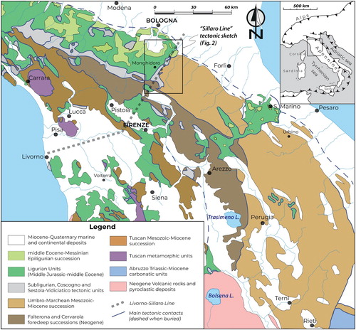
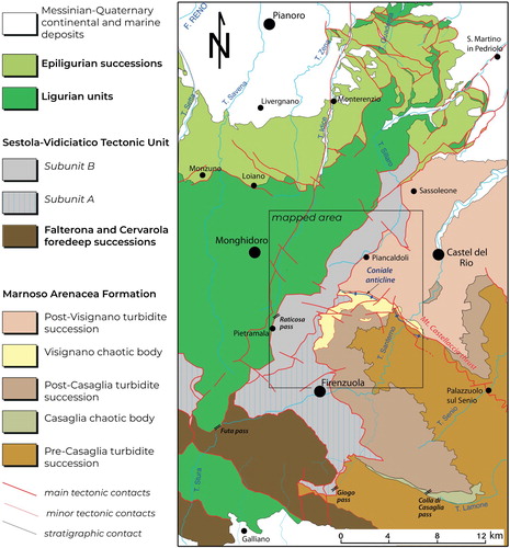
Figure 2. Structural map of the ‘Sillaro Line’ area. The box indicates the area mapped in the Main Map.
The chaotic body has been considered as part of the Sestola-Vidiciatico Tectonic Unit (SVU) (CitationBettelli et al., 2012; CitationVannucchi et al., 2008 and references therein) and defined as a tectonic mélange composing the shear zone between the Ligurian wedge and the foreland deposits.
Along the Sillaro Line, the Visignano chaotic body (VIS) (, Main Map), formerly known as the ‘Visignano olistostrome’ (CitationLanduzzi, 2006 and references therein), represents another large intercalation ∼200-300 m thick, interposed within the upper Serravallian-lower Tortonian MA (CitationMartelli, 2014). We clearly define the components of the VIS and compare them with the overthrusting Ligurian Units and the SVU. This is fundamental to better define the composition of the frontal part of the Ligurian wedge and to constrain the timing of the deformation of the area.
This new geological map focused on i) the distinction of the SVU in two different subunits and careful characterization of their boundaries; ii) the definition of the components of the VIS chaotic unit on the base of a detailed field mapping and new biostratigraphic data; iii) the correlation between extrabasinal elements inside the underthrusting units and the components of the overthrusting unit. This allows to: i) better define the architecture of the frontal part of the Ligurian wedge during the middle-late Miocene and ii) constrain the timing of the deformation phases affecting this portion of the Northern Apennines in that period.
2. Methods
The geological map was produced from observations collected at the 1:10.000 scale and accompanying stratigraphic, structural and biostratigraphic analyses. The mutual relationships between tectonic contacts, the geometry of the different stratigraphic units, and the stratigraphic unconformities of different rank allowed the reconstruction of the tectono-stratigraphic evolution of the mapped area. The results are documented in the attached 1:25.000 scale map (see Main Map), using the topographic maps at 1:10.000 and 1:5.000 provided by the Tuscany and Emilia Romagna administrations respectively. The distinction among different chaotic units (i.e. sedimentary mélange, tectonic mélange, broken formation) followed specific criteria defined in the literature (e.g. CitationBettelli et al., 2004; CitationBettelli & Panini, 1989; CitationFesta et al., 2019).
3. Regional setting
The Northern Apennines () are the result of the convergence and collision between the European and Adria plates (CitationVai & Martini, 2001 and references therein). After the middle Eocene, an already formed oceanic submarine accretionary prism constituted by the Ligurian Units (CitationPrincipi & Treves, 1984) progressively overrode the subducting continental Adria plate and its sedimentary cover (Tuscan and Umbro-Marchean units). Since the middle Eocene to late Miocene, the Ligurian accretionary prism has been unconformably overlain by the forearc slope sediments of the Epiligurian succession (CitationRicci Lucchi, 1986; CitationRicci Lucchi & Ori, 1985).
At least from early to middle Miocene, the relative displacement between the Ligurian accretionary prism and the Adria plate sedimentary cover was accommodated by deformation localized within a 100-500-m-thick shear zone. This zone now crops out as a tectonic mélange, the SVU, in the southeastern part on the Emilia Apennines. The more coherent Subligurian Units represent the same shear zone to the northwest (CitationVannucchi et al., 2008; Citation2012).
At present, the shear zone represented by the SVU is cut by several folds and thrusts but the age of its deactivation is not well constrained. CitationVannucchi et al., 2008 suggest a Serravallian or younger deactivation of the shear zone on the base of the youngest age of the slices that were tectonically recycled within the SVU, but our careful mapping suggests that these slices lie outside the tectonic mélange (see discussion) allowing for an older de-activation of the shear zone.
4. Data
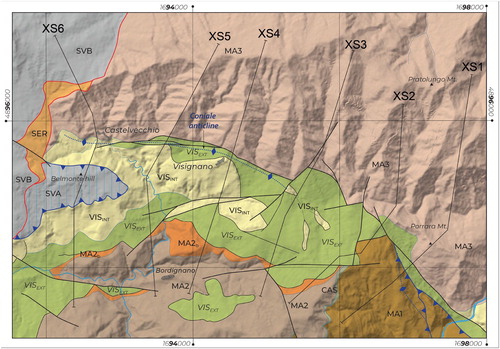
The study area (, Main Map) is located along the Sillaro Valley. Here the Ligurian Units overthrust the Umbrian-Marchean Units through the tectonic interposition of the SVU and local slices of Serravallian marls (SER).
4.1. Stratigraphy of the study area
4.1.1. Ligurian Units
Within the study area, the Ligurian Units are represented by the Leo and Monghidoro tectonic units (LEO and MOH, respectively) (Main Map, ; CitationBettelli, Boccaletti et al., 2002; CitationBettelli, Panini et al., 2002). The differences between these tectonic units are mainly lithostratigraphic and probably related to different depositional environments within the Ligurian ocean (see legend of the Main Map), while their deformation style is similar throughout the whole sequence, even if strongly influenced by the lithology (CitationBettelli & Vannucchi, 2003; CitationVannucchi & Bettelli, 2002).
4.1.2. Sestola-Vidiciatico Tectonic Unit
The SVU is a tectonic mélange (CitationVannucchi et al., 2008 and reference therein) made by m-to-km–size tectonic slices, separated by mechanical contacts. Composition and areal distribution allow the subdivision of the SVU into two different subunits (Bettelli & Panini, Citation1992), structurally independent one from the other: the Sestola-Vidiciatico tectonic subunit A (SVA) (Chaotic unit A in Bettelli & Panini, Citation1992) and the Sestola-Vidiciatico tectonic subunit B (SVB) (Chaotic unit B or Carpinaccio unit in Bettelli & Panini, Citation1992 and CitationBettelli, Panini et al., 2002).
The SVB crops out along the Sillaro Line, from Sasso di Castro to Sassoleone and Gesso area (). It is mainly formed by large slices of strongly deformed pelagic shales intercalated with marls and/or calcareous or siliciclastic turbidites of Late Cretaceous to?middle Miocene age (CitationBettelli, Boccaletti et al., 2002; CitationPanini et al., 2002). This subunit includes tectonic slices pertaining to the Ligurian Units. The mapped units include the Val Samoggia varicolored shale (AVS, Bettelli & Panini, Citation1992) ((a)), the Sillano formation (SIL) ((e)), including also blackish shale alternated to siliceous calcilutite (SILa) and deep-sea carbonates to hybrid turbidites alternating with shales (SILb) (CitationNirta et al., 2007), the Mt. Morello formation (MLL, CitationBortolotti et al., 2009) ((c), (a)) and siliciclastic and calcareous turbidites (HLM). Subordinate amounts of debris flow deposits (BAP) of uncertain age ((b)), mainly deriving from the reworking of the AVS, are also present. The new fieldwork and biostratigraphic analyses revealed that the SVB contains slices of marls, shales and peculiar biocalcarenites and arenitic turbidites (MSB) ranging in age from late Eocene/early Oligocene to?early Miocene (). Some of these latter slices were already distinguished in CitationBenini et al. (2009) and CitationFarabegoli (2009) who correlated them partly to the Epiligurian succession or the Subligurian Units, respectively.
Figure 3. Field occurrence of the elements embedded in the SVU and VIS: (a) Val Samoggia varicolored shale (AVS) in the Carpinaccio unit (SVB) south-west of Belmonte Hill; (b) tectonized debris flow deposits (Shaly polygenic breccias -BAP) in the SVA, west of Peglio (c) Monte Morello formation in the Carpinaccio unit (SVB) 2 km South of Pietramala; (d) Fiumalbo shales and Marmoreto marls (FMC) of the SVA near Firenzuola (e) Block in Matrix fabric of tectonic origin in Sillano Fm, in the SVA; (f) shaly marly succession (VISa) topping the chaotic assemblage of the VIS, south of Castelvecchio; (g) overturned stratigraphic contact between the Marnosa-Arenacea Fm (MA3) laying on top of the VIS here represented by the Val Samoggia varicolored shale (VISAVS), approximately 0,5 km west of Porrara Mt; (h) soft sediment deformation of the marly succession topping the VIS (VISa), Santerno Valley, 1 km SE of Porrara Mt. Refer to the Main Map for the cited locations.
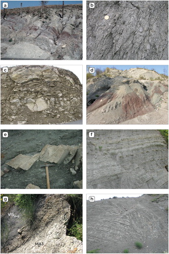
Figure 4. Panoramic views of lithologies and of their relationships in the mapped area: (a) tectonic superposition through low angle fault of the SVB above of the SVA of the Sestola-Vidiciatico tectonic unit in the area between Peglio and Pietramala; the SVB is here represented by km-sized marly limestone tectonic slice of Monte Morello Fm (MLL) embedded in a chaotic assemblage of Sillano Fm (SIL) and Val Samoggia varicolored shales (AVS), here the SVA mostly consists of Shaly poligenic breccias (BAP); (b) contact between the Shaly polygenic breccias (BAP) and a marly to shaly-arenaceous turbidites succession of Serravallian age (SER), basal portion of the SVB, west of Castelvecchio; (c) panoramic view of the VIS (VISa and VISAVS) near the Casogna Village (Santerno Valley), here unconformably covered by the Tortonian portion of the Marnoso-Arenacea Fm (MA3) and on their turn overthrusted, through the Mt. Castellaccio thrust, by the Langhian-Serravallian portion of the Marnoso Arenacea Fm (MA1); (d) overthrusting of the SVA above the VIS south of the Peglio Village, the VIS here consists of turbiditic sandstones of Serravallian age (VISb) and chaotic Sillano Fm (VISSIL); (e) Shaly marly succession topping the Visignano chaotic body (VISa) folded in a close box fold, approximately 300 m south of Castelvecchio; (f) shaly marly succession (VISa) showing soft-sediment deformation and embedded in a chaotic assemblage of Sillano Fm fragments (VISSIL) within the of the VIS, 1,5 km east of the Visignano Village.
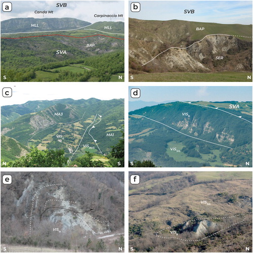
Table 1. Biostratigraphic data from samples collected in the mapped area.
The structural position, general composition and internal structure of the SVB are similar to the SVU cropping out from Suviana (BO) to the Val Secchia (CitationRemitti et al., 2007; Citation2012; CitationVannucchi et al., 2008). However, the composition of the SVB differs from the composition of the SVU elsewhere, given the presence of slices of AVS, large slices of MLL and the peculiar composition and age of the MSB components.
The SVA crops out in the internal, SW area going from the Giogo Pass to Peglio (). It consists of slices of thick submarine debris flow deposits (BAP) ((b)) and large slices of pelagic shales intercalated with marls and/or calcareous turbidites, of Upper Cretaceous to lower Eocene age (SIL and HLM in the Main Map; Bettelli et al., Citation2002) ((e)). Moreover, the SVA contains slices of marls, shale and arenitic turbidites (FMC) ranging in age from the late Eocene to early Langhian (middle Miocene) ((d)). Age, stratigraphy, sedimentology and lithological composition of the FMC exotic blocks suggest a correlation with the Fiumalbo shales, Marmoreto marls, Civago marls, Baigno marls or Suviana sandstones (CitationBenini et al., 2014; CitationBettelli, Boccaletti et al., 2002) elsewhere representing portions of the lithostratigraphic units included in the SVU. Therefore, the SVA shares a similar composition with the SVU cropping out elsewhere along the Northern Apennines excluding the SVB.
4.1.3. Umbrian-Marchean Units
The Marnosa Arenacea formation (MA) is a turbidite succession, >4000 m thick, deposited in the foredeep basin developed in front of the NE-advancing Ligurian wedge (CitationRicci Lucchi, 1975). Following CitationLanduzzi (2006) and CitationTinterri and Tagliaferri (2015), the Casaglia (CAS) and the Visignano (VIS) chaotic bodies (CitationBruni, 1973; CitationDe Jager, 1979; CitationLucente et al., 2002; CitationLucente & Pini, 2003; Citation2008; CitationOgata et al., 2016; Citation2019) represent lithostratigraphic markers, allowing the subdivision of the MA succession in MA1 (deposited before CAS), MA2 (deposited between CAS and VIS events), MA3 (deposited after VIS) (Main Map). Both CAS and VIS are composed by a main body with extra-basinal (i.e. Ligurian) blocks and by an associated slump of Miocene marls and thin-bedded turbidites ((f and h)). The main body of CAS crops out SW of the mapped area whereas in the Sillaro area is only represented by the coeval slumped layers (CitationBenini et al., 2014).
The main body of the VIS is formed by extra-basinal material of Ligurian affinity represented by blocks of SIL (VISSIL) and AVS (VISAVS) ((g) and (c, f)) and very sparse debris flow deposits (VISBAP). Rare blocks of FMC (VISFMC), mainly Fiumalbo shale and Marmoreto marl are also present. Marls (VISa, (f)) and sandstones (VISb) of Serravallian and possibly Tortonian age ((d), Main Map; ; see discussion below) locally unconformably cover this chaotic assemblage. These components suggest that the extra-basinal material is sourced (or shared the source) from both the SVA (as testified by the presence of VIS FMC) and the SVB (as testified by the presence of VISAVS).
Considering as a marker the top of the CAS and the basal surface of the VIS, the MA2 thickness decreases abruptly moving toward NE (Main Map, ), showing sharp angular unconformities and the interruption of the CAS itself, that reappears only a few km northeastward. As suggested by several previous works (Ricci Lucchi, Citation1986; CitationRoveri et al., 2002; CitationTagliaferri et al., 2018; CitationTinterri & Tagliaferri, 2015) it is likely that at the time of emplacement of the VIS within the MA basin, the MA was affected by strong synsedimentary propagation of a blind thrust and growth of the related Coniale anticline (; 5; 6). The axial trace of this fold could be followed at the surface only in its western part (Castelnuovo-Visignano area) whereas eastward it evolves into a thrust surface (; 5; 6). Therefore, the VIS was probably emplaced on a structural/topographic high where turbiditic sediments were replaced by pelitic sediments (Main Map and ) as testified by the presence, below the VIS, of marly sediments and thin-bedded turbidites of late Serravallian-Tortonian age (MA2b) and drastic pinch-out of the MA2 sandstone strata (CitationTinterri & Tagliaferri, 2015; ).
Figure 5. Geological Cross sections across the VIS. The lithologies embedded in the VIS are simplified and subdivided between extrabasinal units (VISEXT, including VISAVS, VISSIL, VISBAP, VISFMC) and intrabasinal units (VISINT, including VISa and VISb). The dotted blue line represents the Coniale anticline axial surface. Refer to the Main Map for the complete lithological legend and abbreviations. See for cross section locations.
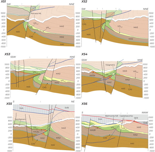
The basal surface of MA3 above VIS is an unconformity on top of different blocks, including blocks of VISAVS ((g) and (c)). The overturned stratigraphic contact between VISAVS and MA3 is preserved NW of Mt. Porrara (Main Map; (g)). The age (early Serravallian) of some of the marls inside the VIS (VISa) (see ) and the structural position of some of the blocks of VISa, surrounded by VISAVS ((f), Main Map) suggest that their deposition has begun before the emplacement of the VIS in its current position. However, near Castelvecchio, the deposition of the MA3 occurs in continuity atop and parallel to the marly or thin-bedded turbidite sediments of VISa (Castelvecchio marls, CitationLanduzzi, 2006; CitationTinterri & Tagliaferri, 2015) without apparent discontinuity. To sum up, at least some of the marls and thin-bedded turbidites (VISa and VISb) can be considered belonging to the VIS, sedimented on the foredeep inner lower slope on top of the very frontal part of the Ligurian wedge and subsequently displaced, together with their original chaotic substratum, in the foredeep basin during the late Serravallian-early? Tortonian.
From Poggio Belmonte to Mt. Belvedere, marls of Serravallian age (SER) crop out at the boundary between the SVA and SVB and the MA3 ((b). They have been previously considered part of the SVU (CitationVannucchi et al., 2008), but the present mapping suggests that they can be better described as tectonic slices of more internal derivation (maybe VISa or marls belonging to MA3), dragged along a major top-to-NE low angle fault.
4.2. Structural setting
In the area, several major faults crop out (see tectonic scheme beside the Main Map). A major thrust fault, at present dipping toward NW (probably due to a later rotation), juxtaposes the Ligurian Units (MOH and LEO) with the SVB; another fault thrusts the MOH over the LEO. The SVA thrusts over the MA including part of the VIS with slip direction towards NE. This latter thrust is cut by another NNE-trending major fault (red line in the Main Map), at present dipping toward the Po plain, putting the SVB on top of the SVA in the south-western part and directly over the MA3 in the northeastern part, with slip direction still toward NE. Along the fault, several slices of SER are dragged and displaced. In the SE part of the map a major thrust, known as the Mt. Castellaccio (CitationTinterri & Tagliaferri, 2015) or S. Benedetto in Alpe thrust (CitationBenini et al., 2014)) cuts through the MA from SE to NW for more than 30 km, becoming progressively blind towards NW (see and ). The fault is associated with an overturned NE verging anticlinal and synclinal folding the MA2, MA3 and intercalated VIS successions. The fold axis plunges toward NW becoming progressively more open and gentler (). Several NE- and SE-trending high angle faults represent the most recent structures. In the western part of the map a major high angle fault, likely with right lateral cinematic, (Idice fault system, Bettelli & Panini, Citation1992) cuts the boundary between the MOH and the LEO Units.
Figure 6. Simplified geological map of the VIS with location of the cross section of . VISINT: Intrabasinal sedimentary deposits; VISEXT extrabasinal sedimentary deposits. Refer to the Main Map for the complete lithological legend and abbreviations.
Inside the SVA and SVB, all the contacts between different lithologies are mechanical and they anneal the pre-existing sedimentary relationships. These contacts may derive from the gravitational or tectonic rework at the front of the Ligurian wedge subsequently deformed inside the shear zone between the Ligurian wedge and the Umbro-Marchean Units.
Similarly, inside the VIS most of the contacts are mechanical ((e and f)). They may be possibly inherited from the structuration of the frontal part of the prism from which the VIS components derive, or due to the emplacement of the VIS, even if some of the stratigraphic contacts at the base of VISa and VISb are preserved.
5. Discussion
The presented map gives several constraints on the interplay, during the early-middle Miocene, between the overthrusting of the Ligurian wedge atop the Umbro-Marchean Units, the sedimentation inside the foredeep basin (on the inner and outer slopes), the deformation of the foredeep deposits and, at the end, the exhumation phase.
5.1. Considerations on the composition of SVA, SVB, VIS and frontal part of the Ligurian wedge
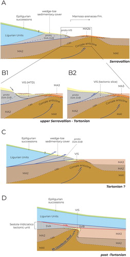
Following the interpretation by CitationRemitti et al. (2007) and CitationVannucchi et al. (2008), the SVU resulted from the underthrusting during the Miocene by frontal tectonic erosion of a proto-mélange forming the frontal part of the overriding plate. The proto-mélange was made by a former accretionary prism (made by Ligurian Units) and by its sedimentary cover. Given its composition, the proto-mélange of the SVA was made by already deformed Ligurian Units (SIL and HLM) and their wedge-toe sedimentary cover (BAP and FMC), while for the SVB the proto-mélange also included AVS and MLL blocks and its wedge-toe sedimentary cover (BAP and MSB) ((a)).
Figure 7. Proposed model for the tectonic evolution of the Northern Apennines frontal accretionary wedge along the ‘Sillaro Line’ during late Miocene. See text for discussion.
MSB probably originated from slope deposits, unconformably sedimented, in a paleogeographic domain intermediate between the Epiligurian domain and the foredeep inner lower-slope.
The age of the youngest slope deposits involved inside the SVU constrains the age of the underthrusting of the proto-mélange (closure of the deposition atop the frontal prism), therefore the SVB should have been underthrusted from the early Miocene while the SVA from the middle Miocene.
The VIS derived from the frontal part of the overriding plate and, since it contains blocks of both the SVA and SVB, at the age of its emplacement (late Serravallian/Tortonian) the frontal part of the wedge should have been formed by both the SVA (including its peculiar FMC blocks) and SVB components (including its peculiar AVS blocks) and the overtaking of the SVA by the SVB should have occurred later on ((a)).
5.2. Considerations on the emplacement of VIS
In literature, the VIS (e.g. CitationLanduzzi, 2006) is considered a mass transport deposits (MTD) deriving from the frontal part of the Ligurian wedge. However, the current data are alternatively compatible with a tectonic emplacement of the frontal part of the Ligurian wedge atop the already tectonically uplifted MA2 ((b)). After this emplacement, the fault at the base of the VIS was deactivated and probably replaced by a more internal thrust moving the SVA over the internal part of the VIS, while the external part was sealed by the deposition of MA3. In turn, the SVB and the Ligurian wedge overthrust the MA3 ((b)).
6. Deformation history
At the time of the VIS emplacement, as already claimed by various authors (Ricci Lucchi, Citation1986; CitationTagliaferri et al., 2018; CitationTinterri & Tagliaferri, 2015), the MA was already deformed by the Coniale anticline ((b)). This implies that the deformation front of the overthrusting Ligurian wedge cut through the sedimentary cover of the lower plate, differently from what was suggested by the underthrusting of almost undeformed older foredeep deposits (CitationVannucchi et al., 2008). This probably preludes to a change in the dynamics of the Northern Apennines.
At the same time, as testified by the VIS components, deformed Ligurian Units and their sedimentary cover, pertaining both to the SVA and SVB, composed the toe of the Ligurian wedge. This is true either if we consider the VIS as an MTD deriving from the toe or the toe itself.
However, after the emplacement, the VIS itself is overthrust by the SVA and sealed, in its most external part, by the sedimentation of the MA3. Then the whole sequence is involved in the folding of the Coniale anticline and cut by the Mt. Castellaccio thrust (c).
The Coniale anticline, overturned in the eastern sector, becomes progressively a very gentle open fold in the western sector until disappearing below the Ligurian Units ().
Then a major fault brought the SVB on top of the SVA and the MA ((d)). The meaning of this fault (base of the SVB) is still questionable. It is a low angle fault, at present tilted toward the north, bringing older material on top of younger material traditionally mapped as a thrust at least in the northern segment (CitationFarabegoli, 2009). Northeast of the mapped area the fault ends in a series of imbricated thrusts bringing the Ligurian and Epiligurian units on top of the late Miocene MA and the overlying late Miocene- Pliocene succession (CitationFarabegoli, 2009; CitationPini, 1999). However, SW of the mapped area (Futa Pass area), the Ligurian Units are directly superposed on the Tuscan Units (i.e. without the SVU that should have been sandwiched between the two) possibly by the same fault. Moreover, between Futa Pass and Sasso di Castro both the SVB and the Ligurian Units show wedge shape geometry with an abrupt decrease in thickness towards SW. Therefore, in some cases, this shear zone seems to display the characteristic of low angle normal fault driving tectonic elision. However, the nature of this contact is still uncertain.
The Coniale anticline closure towards NW does not allow to infer whether the base of the SVB is folded or not, thus if the fault at the base of the SVB was active after or before the Mt. Castellaccio thrust.
Considering the SER slices as not being part of the SVU implies that the SVU mélange did not incorporate material up to Serravallian, as suggested before. Since Serravallian, then, the mechanism of frontal tectonic erosion suggested by CitationVannucchi et al. (2008) was likely no longer active and a change in the deformation mechanisms affecting the shallowest portion of the chain occurred. This is coherent with the activation of deeper décollement actively deforming the foredeep deposits (e.g. the Mt. Castellaccio thrust)
Several vertical faults, cutting all the pre-existing low angle major faults, record the last stage of deformation in the area, likely allowing the different rates of exhumation of the different sectors and generally accommodating the small amounts of lateral displacement.
7. Conclusions
The new data suggest that: (i) before early Serravallian the components feeding both the SVA and SVB were not completely underthrust and they formed the frontal part of the Ligurian wedge; (ii) after the late Serravallian, the SVU likely no longer represented a major active shear zone; (iii) after the emplacement of the VIS, SVB and the overlying Ligurian wedge were progressively detached from the underlying SVA by a major shallow-dipping fault characterized by top to the NE kinematics.
Software
The geological map was first digitized in GIS environment using qGIS (2.18 version) and then edited along with map insertions using Adobe Illustrator CC.
Panini_et_al_Main_Map.pdf
Download PDF (81.1 MB)Acknowledgments
This work was supported by the University of Modena and Reggio Emilia [FAR grants to FR]. We thank A. Festa, G.A. Pini and N. Scarle for their helpful reviews and suggestions.
Disclosure statement
No potential conflict of interest was reported by the author(s).
Additional information
Funding
References
- Benini, A., De Nardo, M. T., & Severi, P. (2009). Note illustrative della Carta Geologica d’Italia alla scala 1:50.000. Foglio 238. Castel S. Pietro Terme. ISPRA – RER.
- Benini, A., Martelli, L., Poccianti, C., & Rosselli, S. (2014). Note illustrative della Carta Geologica d’Italia alla scala 1:50.000. Foglio 253. Marradi. ISPRA – RER.
- Bettelli, G., Boccaletti, M., Cibin, U., Panini, F., Poccianti, C., Rosselli, S., & Sani, F. (2002). Note Illustrative della Carta Geologica D’Italia alla scala 1:50.000, foglio 252 - Barberino del Mugello. Servizio Geologico d’Italia-Regione Emilia Romagna.
- Bettelli, G., Conti, S., Panini, F., & Vannucchi, P. (2004). Mapping of chaotic rocks in Abruzzo (central Apennines). Comparison with selected examples from northern Apennines. In G. Pasquarè, & C. Venturini (Eds.), Mapping geology in Italy (pp. 199–206). S. EL. CA.
- Bettelli, G., & Panini, F. (1989). I mélanges dell'Appennino settentrionale, dal T. Tresinaro al T. Sillaro. Memorie della Societa Geologica Italiana, 39 (1987), 187–214.
- Bettelli, G., & Panini, F. (1992). Liguridi, mélanges e tettoniti nel complesso caotico lungo la “linea del Sillaro” (Appennino Settentrionale, Province di Firenze e Bologna). Memorie Descrittive Della Carta Geologica d’Italia, 46, 387–415.
- Bettelli, G., Panini, F., & Capitani, M. (2002). Carta geologico-strutturale dell’Appennino emiliano sudorientale. In P. Barchiesi, A. Angelelli, & S. Forni (Eds.), Atti del terzo seminario sulla Cartografia geologica (pp. 47–52). LABANTI.
- Bettelli, G., Panini, F., Fioroni, C., Nirta, G., Remitti, F., Vannucchi, P., & Carlini, M. (2012). Revisiting the geology of the “Sillaro Line”, Northern Apennines, Italy. Rendiconti Online Della Società Geologica Italiana, 22, 14–17.
- Bettelli, G., & Vannucchi, P. (2003). Structural style of the offscraped Ligurian oceanic sequences of the Northern Apennines: New hypothesis concerning the development of mélange block-in-matrix fabric. Journal of Structural Geology, 25(3), 371–388. https://doi.org/10.1016/S0191-8141(02)00026-3
- Bortolotti, V. (1966). La tettonica trasversale dell’Appennino: 1, La linea Livorno-Sillaro. Bollettino della Società geologica italiana, 85, 529–540.
- Bortolotti, V., Principi, G., & Sani, F. (2009). Carta Geologica d'Italia alla scala 1:50.000, Foglio 264 “Borgo San Lorenzo”. ISPRA - Servizio Geologico d’Italia.
- Bruni, P. (1973). Considerazioni tettoniche e paleogeografiche sulle serie dell’Appennino bolognese tra le valli dell’Idice e del Santerno. Memorie della Societa Geologica Italiana, 12(2), 157–185.
- De Jager, J. (1979). The relation between tectonics and sedimentation along the “sillaro Line” (Northern Apennines, Italy). Geologica Ultraiectina, 19, 95.
- Farabegoli, E. (2009). Carta Geologica D’Italia alla scala 1:50.000, foglio 238 “Castel S.Pietro Terme”. A.T.I. - S. EL. CA. - L.A.C. - SYSTEMCART, Firenze. Servizio Geologico d’Italia-Regione Emilia Romagna.
- Festa, A., Pini, G. A., Ogata, K., & Dilek, Y. (2019). Diagnostic features and field-criteria in recognition of tectonic, sedimentary and diapiric mélanges in orogenic belts and exhumed subduction-accretion complexes. Gondwana Research, 74, 7–30. https://doi.org/10.1016/j.gr.2019.01.003
- Fornaciari, E., Di Stefano A., Rio, D. & Negri, A. (1996). Middle Miocene quantitative calcareous nannofossil biostratigraphy in the Mediterranean region. Micropaleontology, 42, 37–63.
- Ghelardoni, R. (1965). - Osservazioni sulla tettonica trasversale nell’Appennino Settentrionale. Bollettino della Società geologica italiana, 84, 277–290.
- Landuzzi, A. (2006). Syn-depositional emplacement of the Liguride allochthon in the Miocene foredeep of the western Romagna Apennines. In G. Pasquarè, & C. Venturini (Eds.), Mapping Geology in Italy (pp. 219–226). S. EL. CA.
- Lucente, C. C., Manzi, V., Ricci Lucchi, F., & Roveri, M. (2002). Did the Ligurian Sheet cover the whole thrust belt in Tuscany and Romagna Apennines? Some evidence from gravity emplaced deposits. Bollettino della Società geologica italiana, 1, 393–398.
- Lucente, C. C., & Pini, G. A. (2003). Anatomy and emplacement mechanism of a large submarine slide within a Miocene foredeep in the northern Apennines. Italy: A field perspective. American Journal of Science, 303(7), 565–602. https://doi.org/10.2475/ajs.303.7.565
- Lucente, C. C., & Pini, G. A. (2008). Basin-wide mass-wasting complexes as markers of the Oligo-Miocene foredeep-accretionary wedge evolution in the Northern Apennines, Italy. Basin Research, 20(1), 49–71. https://doi.org/10.1111/j.1365-2117.2007.00344.x
- Martini, E. (1971). Standard Tertiary and Quaternary calcareous nannoplankton zonation. In A. Farinacci (Ed.), Proceedings 2nd international conference planktonic microfossils (Vol. 2, p. 739–785). Roma: Tecnoscienza.
- Martelli, L. (2014). Carta Geologica D’Italia alla scala 1:50.000, foglio 253 “Marradi.” SYSTEMCART, Roma. Servizio Geologico d’Italia-Regione Emilia Romagna.
- Nirta, G., Principi, G., & Vannucchi, P. (2007). The Ligurian Units of Western Tuscany (northern Apennines): insight on the influence of pre-existing weakness zones during ocean closure. Geodinamica Acta, 20(1-2), 71–97. https://doi.org/10.3166/ga.20.71-97
- Ogata, K., Festa, A., Pini, G. A., Pogačnik, Ž, & Lucente, C. C. (2019). Substrate deformation and incorporation in sedimentary mélanges (olistostromes): Examples from the northern Apennines (Italy) and northwestern Dinarides (Slovenia). Gondwana Research, 74, 101–125. https://doi.org/10.1016/j.gr.2019.03.001
- Ogata, K., Storti, F., Balsamo, F., Tinterri, R., Bedogni, E., Fetter, M., Gomes, L., & Hatushika, R. (2016). Sedimentary facies control on mechanical and fracture stratigraphy in turbidites. GSA Bulletin. doi: https://doi.org/10.1130/B31517.1; Data Repository item 2016252
- Panini, F., Bettelli, G., Pizziolo, M., Bonazzi, U., Capitani, M., Gasperi, G., Fioroni, C., & Fregni, P. (2002). Note illustrative alla Carta Geologica d’Italia a scala 1:50.000. Foglio 237 “Sasso Marconi”. S.EL.CA, Firenze. Servizio Geologico d’Italia/Regione Emilia-Romagna.
- Pini, G. A. (1999). Tectonosomes and olistostromes in the argille scagliose of the northern Apennines, Italy: Geological Society of America Special Paper 335.
- Principi, G., & Treves, B. (1984). - Il sistema corso-appenninico come prisma d’ accrezione. Riflessi sul problema generale del limite Alpi-Appennini. Memorie della Societa Geologica Italiana, 28, 549–576.
- Remitti, F., Bettelli, G., Panini F., Carlini M., & Vannucchi P. (2012). Deformation, fluid flow, and mass trasfer in the forearc of convergent margins: A two-day field trip in an ancient and exhumed erosive convergent margin in the Northern Apennines. In P. Vannucchi & D. Fisher (Eds.), Deformation, Fluid flow, and mass transfer in the forearc of convergent margins: Field guides to the Northern Apennines in Emilia and in the Apuan Alps (Italy). The geological society of America field guide (Vol. 0028, pp. 1–34). https://doi.org/10.1130/2012.0028(01).
- Remitti, F., Bettelli, G., & Vannucchi, P. (2007). - Internal structure and tectonic evolution of an underthrust tectonic mélange: The Sestola-Vidiciatico tectonic unit of the Northern Apennines, Italy. Geodinamica Acta, 20(1–2), 37–51. doi:10.3166/ga.20.37-51
- Ricci Lucchi, F. (1975). Miocene paleogeography and basin analysis in the peri-Adriatic Apennines. In G. Squires (Ed.), Geology of Italy (vol. 2, 129–236). PELS-Tripoli
- Ricci Lucchi, F. (1986). The Oligocene to recent foreland basins of the northern Apennines. In P. A. Allen & P. Homewood (Eds.), Foreland basins. International Association of Sedimentologists Special Publication (vol. 8, p. 103–139). Blackwell Publishing Ltd. https://doi.org/10.1002/9781444303810.ch6.
- Ricci Lucchi, F., & Ori, G. G. (1985). Field excursion D: Syn-orogenic deposits of a migrating basin system in the NW adriatic Foreland. In P. H. Allen, P. Homewood, & G. Williams (Eds.), “Excursion Guidebook” (pp. 137–176). Foreland Basins Symp.
- Roveri M., Ricci Lucchi F., Lucente C.C., Manzi V., & Mutti E. (2002). Stratigraphy, facies and basin fill history of the Marnoso-Arenacea formation. In E. Mutti, F. Ricci Lucchi & M. Roveri (Eds.), Revisiting turbidites of the Marnoso-arenacea Formation and their basin Margin equivalents: problems with classic models. 64th Eage Conference And Exhibition, Florence, Italy 27-30 May 2002, Excursion Guidebook, part III, p. III/1-III/15.
- Tagliaferri, A., Tinterri, R., Pontiggia, M., Da Pra, A., Davoli, G., & Bonamini, E. (2018). Basin-scale, high-resolution three-dimensional facies modeling of tectonically confined turbidites: An example from the Firenzuola system (Marnoso-arenacea Formation, Northern Apennines, Italy). AAPG Bulletin, 102(8), 1601–1626. https://doi.org/10.1306/12081716521
- Tinterri, R., & Tagliaferri, A. (2015). - The syntectonic evolution of foredeep turbidites related to basin segmentation: Facies response to the increase in tectonic confinement (Marnoso-arenacea formation, Miocene, Northern Apennines, Italy). Marine and Petroleum Geology, 67, 81–110. https://doi.org/10.1016/j.marpetgeo.2015.04.006
- Vai, G. B., & Martini, I. P. (Eds.). (2001). Anatomy of an Orogen: The apennines and the adjacent mediterranean basins. Kluver Academic Publishers.
- Vannucchi, P., & Bettelli, G. (2002). - Mechanisms of subduction accretion as implied from the broken formations in the Apennines, Italy. Geology, 30(9), 835–838. https://doi.org/10.1130/0091-7613(2002)030<0835:MOSAAI>2.0.CO;2
- Vannucchi, P., Remitti, F., & Bettelli, G. (2008). Geological record of fluid flow and seismogenesis along an erosive subducting plate boundary. Nature, 451(7179), 699–703. doi:10.1038/nature06486
- Vannucchi, P., Remitti, F., & Bettelli, G. (2012). Lateral variability of the erosive plate boundary in the Northern Apennines, Italy. Italian Journal of Geosciences, 131(2), 215–227. https://doi.org/10.3301/IJG.2012.11