
 ?Mathematical formulae have been encoded as MathML and are displayed in this HTML version using MathJax in order to improve their display. Uncheck the box to turn MathJax off. This feature requires Javascript. Click on a formula to zoom.
ABSTRACT
Achieving sustainable development through China’s national territory spatial planning requires comprehensive knowledge of all land characteristics. This paper introduces a land-type map of Jiangsu province (104 km2) in eastern China to provide such knowledge. The land-type map focuses on both physical geographic components (e.g. climate types, landforms, and soil types) and human-related components (e.g. land-use types and intensities). These components were represented by parameter layers and integrated with the help of the Geographic Information System (GIS) overlay function. A hierarchical land-type classification system was generated to provide land mapping units that represented certain degrees of geographic homogeneity and land-use potential. Trading off the relationship between resource protection and resource utilization, the space of Jiangsu was divided into seven land-use zones with different land-use policies based on the land-type map. The land-type map can thus be taken into consideration for land planning and management.
1. Introduction
The success of sustainable development depends heavily on land-use policies, which govern the processes of interaction between human activities and geographic environments (CitationLetourneau et al., 2012). Therefore, a land survey that reveals characteristics of land resources and the human–land relationship is one of the most important premises of land-use planning and policy making (CitationDemers, 2014). Given that the core task of land-use planning in China from the 1980s to the 2000s was resource protection, the first and second national land survey focused on land-use types (CitationCai et al., 2009). Currently, national territory spatial planning in China aims to establish a unified system. Integrating all types of spatial planning in China, this unified system requires trade-offs between farmland protection, nature conservation, and resource utilization to achieve sustainable development. However, the third national land survey, which is not yet complete, still focuses on resource utilization characteristics.
Land-type, dividing the geographic environment into entity units, reveals the homogeneity of both the physical geographic characteristics (e.g. climate conditions, landforms, soil types, and land-cover types) and related economic characteristics (e.g. agricultural production) (CitationLacate, 1961; CitationWang et al., 2010; CitationZhao, 1989). Integrating different geographic characteristics, in-depth research has been conducted on the classification and analysis of geographic environment, which is also the origin of landscape and land system research (CitationRowe & Sheard, 1981; CitationSimensen et al., 2018; CitationSmiraglia et al., 2013; CitationVerburg et al., 2013). These studies fill the gap between the highly generalized concept of geographic regions and the array of classes such as soil series and land-use/land-cover types (CitationLacate, 1961; CitationZhao, 1989). However, neither land system research highlighting the human use of land nor landscape research focusing on geo-ecological characteristics could meet the requirements of national territory spatial planning in China. In the 1980s, a standard national land-type classification system integrating climatic condition, landform, soil, and vegetation was introduced in China to provide a framework for the land characteristics survey (CitationZhao, 1989). However, this classification system concentrated only on physical geographic components. These contrasting lines of research have prevented the classification results from being directly applicable to meso-scale land-use planning in China.
To provide a framework for the all-round management of land resources at meso-scale, we propose a land-type classification and mapping method that combines physical geographic components (e.g. climate, landform, and soil) and human-related components (e.g. land-use type and intensity). A case study from Jiangsu province in eastern China at 1:700,000 is provided. Based on the land-type map, the agriculture, ecology, and built-up space in Jiangsu are identified to provide basic knowledge that could determine the most appropriate land-use policy.
2. Material and methods
2.1. Study area
Jiangsu province (30°45′–35°20′N, 116°18′–121°57′E) is located in eastern China and adjacent to the Yangtze River Delta. It is located in the subtropical monsoon climate zone. The plains are the dominant landforms, with low hills and mountains in the north and southwest. It has an approximate area of 104 km2 and a heterogeneous distribution of soil types because of the diversity of water, heat, and topographic conditions. As one of the most economically developed regions of China, the different regions of Jiangsu utilize land resources at different intensities.
2.2. Land-type classification
Existing research generally acknowledges that the interaction between climate, landform, soil, and human activity shapes the appearances and characteristics of land at all scales (CitationLacate, 1961; CitationMucher et al., 2010; CitationVerburg et al., 2013). However, it would be difficult to include all geographic components in a single classification system (CitationSimensen et al., 2018). According to existing land classification research (CitationMucher et al., 2010; CitationRossiter, 1996; CitationRowe & Sheard, 1981; CitationSmiraglia et al., 2013), land surface can be divided into different land mapping units based on the importance of different geographic components to different land-use potentials at different scales () (CitationRossiter, 1996). To ensure that the land mapping units in this study can be compared with the results of other land management studies, the classification systems of climate, landform, and soil were consistent with national standards in China ().
Figure 1. Classification system of land-type units.
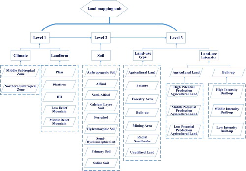
Table 1. The sources and main uses of data used in this research.
The land-use intensity can be represented by the output of land resource utilization (CitationErb et al., 2013). Thus, agricultural lands were classified into three levels with different Net Primary Productivity (NPP) as a proxy for land-use intensity (). Moreover, to identify different human activity intensities in built-up areas, built-up lands were classified based on different nighttime light (). The natural breaks (Jenks) that identifies data groups with similar values and maximize the difference between classes were used in the land-use intensity classification (CitationJenks, 1967). This enabled a qualitative assessment that was helpful in identifying different land-use zones, because the higher levels indicated intensive human activity. To ensure that the land mapping units could be applied to land management, mining areas were identified based on land-use type data ().
The geographic components mentioned in were parameter layers covering the whole area. The climate types, soil types, and land-use types were vector layers. The landform classification results were converted to vector layers using Esri ArcGIS10.1. According to the hierarchical classification system (), the vector layers were integrated using the overlay function, which created a new layer through dividing the original elements into new elements by intersecting the input layers with each other. The new elements integrated all the attributes of the original layers. Based on the spatial relationship between the overlay results and land-use intensity layers in , agricultural lands and built-up lands were further classified into different land-use intensities. The land-type map was drawn at the standard scale of 1:700,000, with a minimum mapping unit of 5 ha.
Level 1 units. Climate types and landform types were used to classify Level 1 units (). Solar radiation was classified and used as a proxy for climate types, because solar radiation is one of the basic sources that most affects biological processes and materials exchange on the Earth’s surface (CitationHerman, 2010). Because different elevations affect rainfall and temperature distribution, which are often the main physical factors responsible for differences in soil, vegetation, and land-use types, landforms were classified and used as a proxy for landform types (CitationMacmillan & Shary, 2009).
Level 2 units. Soil supports the growth of plants and animals, thereby affecting land-use potential in a Level 1 unit. Therefore, Level 1 units and soil types were combined to classify Level 2 units. By comprehensively representing the characteristics of climate, landform, and soil type, Level 2 units directly describe the natural land-use potential (CitationLacate, 1961).
Level 3 units. Land-use and land-cover maps are key terrestrial features, as shown by various spatial planning and management studies (CitationArsanjani et al., 2013; CitationBrown & Duh, 2004). Comparing with land-cover research which indicates the natural environments such as forest or open water, subtle changes in land management and land use practices have important consequences on the environment (CitationVerburg et al., 2011). Therefore, land-use types were used to classify Level 3 units to comprehensively reflect the impact of human activity on the environment. Moreover, since land-use intensity illustrates different human activities under comparable land-use regimes and is an important component of human well-being (CitationErb et al., 2013), this study classified the utilization intensity of agricultural lands and built-up lands (). In summary, land-use type, land-use intensity, and Level 2 units were used for the classification of Level 3 units.
2.3. Land-use zoning
The national territory spatial planning in China includes five levels. National- and provincial-scale planning focuses on macro policy control (CitationCai et al., 2009; CitationHuang et al., 2012). Land-use zones specifically represent the general land-use potential that provides the basis of policy making pertaining to the land, like farmland protection or urban development. Given that land mapping units are too fragmented to represent a homogenous land-use zone, a generalization process is required. In this study, the generalization process focused on logical deduction rather than the generalization of graphic objects. Therefore, this study analyzed each land characteristic in the land-type classification system to reveal the suitability and constraints of resource utilization (). The correspondence between land mapping units and land-use zones was then constructed based on the coordination of resource protection and utilization ().
Figure 2. Generalization process of land-use zoning based on land-type units.
The generalization methods in this paper included selection, merging, and aggregation (CitationButtenfield & McMaster, 1991). EquationEquation (1)(1)
(1) defines the selection and merging process. Si
represents a land-use zone in the category showed in . Thus, i = 1,2 … 7. AC
is the climate type of a Level 3 unit, and ALA
, AS
, ALU
refer to landform, soil, and land-use type (intensity), respectively. ACn
∩ ALAn
∩ ASn
∩ ALUn
is a criterion that defines a certain land-use zone. According to , a certain land-use zone includes different criteria, and thus n is the number of different criteria. Merging all Level 3 units in accordance with Equationequation (1)
(1)
(1) generated a certain land-use zone as a preliminary result.
(1)
(1) To make the shape of land-use zones more regular and convenient for land management practice, this study adopted the fishnet analysis for zonation and statistics based on Esri ArcGIS10.1. Considering that the minimum mapping unit is 5 ha, the whole area was divided into a 230 m × 230 m squares fishnet. According to equation (2), Area (Si,j) is the area of land-use zone Si
in the j square of the fishnet. Zoning is the final result of land-use zoning in the j square. It is defined as the i type of land-use zone with largest areas in the j square.
(2)
(2)
2.4. Cartography
To prevent map data from being overwritten as a result of map layers being stacked in the wrong order, the map layers in the study were stacked in the following order from top to bottom: (1) appearance elements (outline, title, scale, legend); (2) various textual annotations and point geo-objects; (3) administrative boundaries, road networks, and other line geo-objects; and (4) thematic elements of land-type in which the land-type mapping symbols, top to bottom, denote soil types, land-use types and intensities, and landforms, respectively. Soil types were denoted with hollowed-out texture symbols, and land-use types and intensities were denoted with color symbols. To display the hillshade map in a way that represents landforms correctly, it was placed under the land-use types and intensities layer and set to a 30% transparency. The map projection was Xian 1980/3-degree Gauss-Kruger zone 40 (EPSG: 2364), Datum D_Xian_1980. Esri ArcGIS10.1 was used for the classification process and map production.
3. Results and discussion
To comprehensively represent the spatial geographic patterns, this study used the ‘climate–landform–soil–land-use intensity–land-use type’ to name the land mapping units (Main Map). Together, the terms ‘land-use intensity’ and ‘land-use type’ connote human activity. The land-type classification process led to the identification and mapping of 12 Level 1 units, 48 Level 2 units, and 205 Level 3 units (Supplementary Table 1). The main findings regarding the geographic pattern of the Jiangsu province are as follows.
3.1. Integrated geographic pattern
The main map demonstrates that the physical geographic conditions are core factors affecting the land-use potential. The potential production of agricultural lands in Jiangsu province decreases as one moves from the ocean to inland areas (Main Map). In Jiangsu province, plains account for 94% of the total area (.a). Flat terrain contributed to the accumulation of human activities and resulted in the area of agricultural lands and built-up lands accounting for 61% and 18% of the whole, respectively (.c). Long-standing agricultural activities have changed native soil and resulted in the extensive distribution of anthropogenic soil. Moreover, the proportion of land mapping units with alfisol, semi-alfisol, hydromorphic soil, and semi-hydromorphic soil, which are suitable for agricultural activity, account for more than 35% of the whole area (.b). This has led to dominant agricultural land-types.
Figure 3. Structure of land-type units.
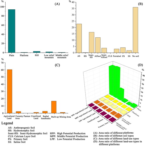
In addition, high relief and poor soil fertility restricted human activity, leading to an extensive forestry areas and pastures distribution in the hills and mountains (.d). Moreover, the natural resources led to a unique land-type (Main Map). For example, radial sandbanks provide resources for wild animals in areas not suitable for human activity. Furthermore, the characteristics of natural resources formed different land-use strategies. For example, in the northeast and northwest parts of Jiangsu province, rich mineral resources formed the long-strip mining land-type. These conditions could lead to different land-use policies in different regions.
Human activity determined land-use policy. The main map shows an agglomeration effect of built-up lands. Moreover, the distributions of built-up lands are adjacent to the railway and Yangtze river, which indicates that the convenience of transportation is important in the formation of urban areas. Each city in Jiangsu has a similar structure – that is, a high intensity or medium intensity of built-up land is always located at the center, which is surrounded by low intensity built-up land, and characterizes a dual urban–rural structure (CitationChan & Wei, 2019). Moreover, the area and intensity of built-up lands in southern Jiangsu are much larger than in the northern part, which indicates that the development of built-up land-types is highly dependent on the local socioeconomic context (CitationVerburg et al., 2011).
3.2. Land-use zoning
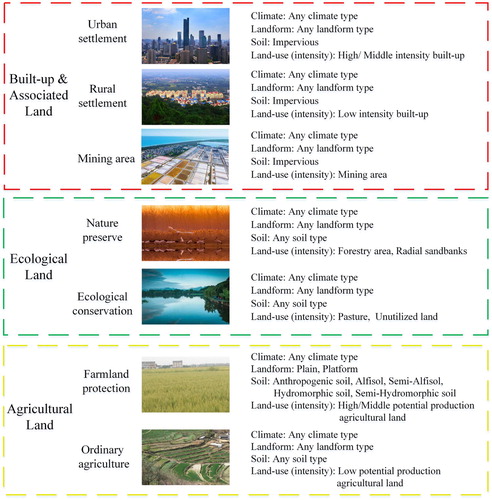
Different land-use policies could be applied in Jiangsu province according to regional geographic patterns of land-use zones. Farmland protection areas with good climatic conditions as well as flat terrain and good soil condition should concentrate on food production to ensure food safety (). Therefore, human activities should be constrained and construction activities should probably not occupy the land resources in this zone. The potential production of agricultural lands in the eastern Jiangsu is high, but the characteristics of saline soil make it difficult to develop agriculture. The poor fertility of primary soils and intensive human activity also constrained the production of agricultural lands, thereby forming an ordinary agriculture zone. In such areas, other agricultural activities could be performed, such as planting orchards rather than food production.
Figure 4. Land-use zoning map based on land-type.
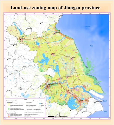
Nature preserves are the core areas that ensure human activity is constrained for other organisms to survive. For example, radial sandbanks in eastern Jiangsu provide important habitats for wild animals like the red-crowned crane. This area could be treated as a national nature reserve to ensure environmental safety. The fragmented forestry areas, pastures, and unutilized areas constitute ecological conservation zones in Jiangsu. These zones are not suitable for intensive human activity owing to the irregular terrain and are important in maintaining ecological landscape connectivity. Protecting the original vegetation and establishing country parks in these areas provide an important base for leisure sports and popular science education.
Land-use zones for urban and rural settlement are areas where human activity is concentrated. The rapid expansion of built-up areas has occupied the agricultural and ecological areas of Jiangsu province (CitationJiang et al., 2016). Curbing the rapid expansion of urban areas by delineating urban development boundaries and improving the efficiency of resource utilization are core tasks in this land-use zone. Moreover, the mining areas in northwest and northeast Jiangsu should be restricted to moderate exploitation based on the carrying capacity of the environment.
3.3. Potential use of land-type map
Comprehensive knowledge of the geographic environment is important in its assessment, protection, and management (CitationMucher et al., 2010; CitationSmiraglia et al., 2013; CitationSimensen et al., 2018). Combining national standards in China and research on the landscape and land system, this study highlighted the role of physical geographic components as well as land-use types and intensity in a land-type map to ensure the land mapping units could reveal the human–land relationship. Moreover, the land-type map in this study generated a land-use zoning map, which provides a framework for land management and land-use policy making in Jiangsu province (CitationHuang et al., 2012; CitationZhao, 1989).
In addition, the classification method, which was based on prior knowledge, has been widely tested (CitationMucher et al., 2010; CitationRowe & Sheard, 1981; CitationSmiraglia et al., 2013; Citationvan Eetvelde & Antrop, 2009). Moreover, the hierarchical classification system ensures the scalability of land mapping units, since high-level units have been proven to control low levels. This characteristic ensures that land mapping units can be generalized to different scales, enabling a comparison with the results of other land management studies given that the classification system of these elements are consistent with the national standards in China. The widely used dataset included in this study ensures the generalization of the classification system in other provinces in China. However, this system cannot replace any of the national land classifications, but rather provides a framework for integrating different classification results.
4. Conclusions
Land-type maps represent comprehensive geographic features at different scales according to land characteristics and reveal the human–land relationship. The present study asserted that meso-scale land-type studies should concentrate on both physical components (e.g. climate, landform, and soil) that control land-use potential and human-related components (e.g. land-use type and intensity).
The contributions are twofold. First, the land mapping units and map provided a framework to analyze the suitability and constraints of resource utilization and land-use zoning, which are the basis of national territory spatial planning in China. The second contribution is that the main map offers a template for land-type mapping. Hopefully, this study will motivate future work in land resource management research to more fully support sustainable development.
Software
The final map and related thematic layers were collected, managed, and processed using Esri ArcGIS 10.1.
03_Main_Map.pdf
Download PDF (17.2 MB)Disclosure statement
No potential conflict of interest was reported by the author(s).
Additional information
Funding
References
- Arsanjani, J. J. , Helbich, M. , Bakillah, M. , Hagenauer, J. , & Zipf, A. (2013). Toward mapping land-use patterns from volunteered geographic information. International Journal of Geographical Information Science , 27 (12), 2264–2278. https://doi.org/10.1080/13658816.2013.800871
- Brown, D. G. , & Duh, J. D. (2004). Spatial simulation for translating from land use to land cover. International Journal of Geographical Information Science , 18 (1), 35–60. https://doi.org/10.1080/13658810310001620906
- Buttenfield, B. P. , & McMaster, R. B. (1991). Map generalization: Making rules for knowledge representation . Longman Scientific & Technical.
- Cai, Y. , Zhang, W. , & Zhao, Y. (2009). Discussion on evolution of land-use planning in China. China City Planning Review , 18 (1), 32–37.
- Chan, K. W. , & Wei, Y. (2019). Two systems in one country: The origin, functions, and mechanisms of the rural-urban dual system in China. Eurasian Geography and Economics , 60 (4), 422–454. https://doi.org/10.1080/15387216.2019.1669203
- Cheng, W. M. , Zhou, C. H. , Chai, H. X. , Zhao, S. M. , Liu, H. J. , & Zhou, Z. P. (2011). Research and compilation of the Geomorphologic Atlas of the People's Republic of China (1:1,000,000). Journal of Geographical Sciences , 21 (1), 89–100. https://doi.org/10.1007/s11442-011-0831-z
- Demers, M. N. (2014). Land classification research: A retrospective and agenda. International Journal of Applied Geospatial Research , 5 (3), 82–92. https://doi.org/10.4018/ijagr.2014070106
- Erb, K. H. , Haberl, H. , Jepsen, M. R. , Kuemmerle, T. , Lindner, M. , Muller, D. , Verburg, P. H. , & Reenberg, A. (2013). A conceptual framework for analysing and measuring land-use intensity. Current Opinion in Environmental Sustainability , 5 (5), 464–470. https://doi.org/10.1016/j.cosust.2013.07.010
- Field, C. B. , Behrenfeld, M. J. , Randerson, J. T. , & Falkowski, P. (1998). Primary production of the biosphere: Integrating terrestrial and oceanic components. Science , 281 (5374), 237–240. https://doi.org/10.1126/science.281.5374.237
- Herman, J. R. (2010). Use of an improved radiation amplification factor to estimate the effect of total ozone changes on action spectrum weighted irradiances and an instrument response function. Journal of Geophysical Research (Atmospheres) , 115 (D23), D23119. https://doi.org/10.1029/2010JD014317
- Huang, Q. H. , Liu, Y. X. , Li, M. C. , Mao, K. , Li, F. X. , Chen, Z. J. , Chen, C. , & Huang, W. (2012). Thematic maps for county-level land use planning in Contemporary China. Journal of Maps , 8 (2), 185–188. https://doi.org/10.1080/17445647.2012.694272
- Jenks, G. F. (1967). The data model concept in statistical mapping. International Yearbook Cartography , 7 , 186–190.
- Jiang, P. H. , Cheng, Q. W. , Gong, Y. , Wang, L. Y. , Zhang, Y. Q. , Cheng, L. , Li, M. C. , Lu, J. C. , Duan, Y. W. , Huang, Q. H. , & Chen, D. (2016). Using urban development boundaries to constrain uncontrolled urban sprawl in China. Annals of the American Association of Geographers , 106 (6), 1321–1343. https://doi.org/10.1080/24694452.2016.1198213
- Lacate, D. S. (1961). A Review of Landtype classification and mapping. Land Economics , 37 (3), 271–278. https://doi.org/10.2307/3159727
- Letourneau, A. , Verburg, P. H. , & Stehfest, E. (2012). A land-use systems approach to represent land-use dynamics at continental and global scales. Environmental Modelling & Software , 33 , 61–79. https://doi.org/10.1016/j.envsoft.2012.01.007
- Macmillan, R. A. , & Shary, P. A. (2009). Chapter 9 landforms and landform elements in geomorphometry. Developments in Soil Science , 33 , 227–254. https://doi.org/10.1016/S0166-2481(08)00009-3
- Mucher, C. A. , Klijn, J. A. , Wascher, D. M. , & Schaminee, J. H. (2010). A new European landscape classification (LANMAP): A transparent, flexible and user-oriented methodology to distinguish landscapes. Ecological Indicators , 10 (1), 87–103. https://doi.org/10.1016/j.ecolind.2009.03.018
- Rossiter, D. G. (1996). A theoretical framework for land evaluation. Geoderma , 72 (3-4), 165–190. https://doi.org/10.1016/0016-7061(96)00031-6
- Rowe, J. S. , & Sheard, J. W. (1981). Ecological land classification - a survey approach. Environmental Management , 5 (5), 451–464. https://doi.org/10.1007/BF01866822
- Shi, X. Z. , Yu, D. S. , Warner, E. D. , Sun, W. X. , Petersen, G. W. , Gong, Z. T. , & Lin, H. (2006). Cross-reference system for translating between genetic soil classification of China and soil taxonomy. Soil Science Society of America Journal , 70 (1), 78–83. https://doi.org/10.2136/sssaj2004.0318
- Simensen, T. , Halvorsen, R. , & Erikstad, L. (2018). Methods for landscape characterisation and mapping: A systematic review. Land Use Policy , 75 (75), 557–569. https://doi.org/10.1016/j.landusepol.2018.04.022
- Smiraglia, D. , Capotorti, G. , Guida, D. , Mollo, B. , Siervo, V. , & Blasi, C. (2013). Land units map of Italy. Journal of Maps , 9 (2), 239–244. https://doi.org/10.1080/17445647.2013.771290
- Townsend, A. C. , & Bruce, D. A. (2010). The use of night-time lights satellite imagery as a measure of Australia's regional electricity consumption and population distribution. International Journal of Remote Sensing , 31 (16), 4459–4480. https://doi.org/10.1080/01431160903261005
- van Eetvelde, V. , & Antrop, M. (2009). A stepwise multi-scaled landscape typology and characterisation for trans-regional integration, applied on the federal state of Belgium. Landscape and Urban Planning , 91 (3), 160–170. https://doi.org/10.1016/j.landurbplan.2008.12.008
- Verburg, P. H. , Erb, K. H. , Mertz, O. , & Espindola, G. (2013). Land system science: Between global challenges and local realities. Current Opinion in Environmental Sustainability , 5 (5), 433–437. https://doi.org/10.1016/j.cosust.2013.08.001
- Verburg, P. H. , Neumann, K. , & Nol, L. (2011). Challenges in using land use and land cover data for global change studies. Global Change Biology , 17 (2), 974–989. https://doi.org/10.1111/j.1365-2486.2010.02307.x
- Wang, J. , Chen, Y. Q. , He, T. , Lv, C. Y. , & Liu, A. X. (2010). Application of geographic image cognition approach in land type classification using Hyperion image: A case study in China. International Journal of Applied Earth Observation and Geoinformation , 12 , S212–S222. https://doi.org/10.1016/j.jag.2009.06.003
- Zhao, S. Q. (1989). 中国1:100万土地类型图制图规范 [Mapping specification of 1:1,000,000 land-type maps in China]. Surveying and Mapping Press.