
ABSTRACT
Deep-seated gravitational slope deformation (DsGSD) represents a relevant geological-geomorphological feature of the landscape and has drawn scientific attention for the past several decades. During a detailed fieldwork in the Ligurian Alps, we identified areas (larger than ca 5 km2), characterized by very low percentage of outcrops, with rock blocks on the watershed and many morpho-tectonic evidences. Through the integration of geological-geomorphological mapping, structural data, photo interpretation, GIS-based analyses, we identified a number of typical DsGSDs. The example here described is one major complex-sagging-type DsGSD that is not present in national land planning and/or management databases but that is likely at the origin of the large-scale landslides which affected the villages of the area. This DsGSD is also located within the Beigua UNESCO Global Geopark, in an area of unique natural and historical value. This study once again highlights the importance of ground truth observations as the basis for further investigations.
1. Introduction
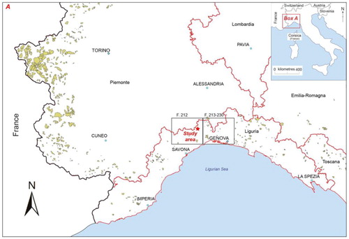
During detailed fieldwork for two recently published 1:50,000 Italian geological maps, the ‘213 – 230 Genova’ (2008, Italian CARG Project; https://www.isprambiente.gov.it/Media/carg/213_GENOVA/Foglio.html) and ‘212 Spigno Monferrato’ sheets (2013, Regione Liguria Cartographic Project; https://www.regione.liguria.it/open-data/item/7174-carta-geologica-regionale-cgr-sc-125000-riferita-al-foglio-212-spigno-monferrato-sc-150000.html), we identified several mountain slope deformations (sensu CitationHungr et al., 2014) in the area straddling the main (tyrrhenian – padan) watershed divide in central Liguria (NW Italy, ). These instability phenomena (well-known as ‘Deep-seated Gravitational Slope Deformations’) involve large rock volumes and clearly influence the mountain-valley morphology at a large scale and usually on long-term basis (i.e. with slow movements) (i.e. CitationCrosta, 1996; Crosta & Zanchi, Citation2000; Dikau et al., Citation1996; Dramis & Sorriso-Valvo, Citation1994; Fioraso, Citation2017).
Figure 1. Distribution of mountain slope deformations (DsGSDs) in the south-western segment of the alpine chain (from IFFI database; https://www.progettoiffi.isprambiente.it/) and location of the geological sheets Spigno and Genova.
The identification of mountain slope deformations, not always unequivocal, often relies on the following evidence: (i) morphological elements similar to those present in fine soil landslides, but at a larger scale; (ii) scale of the structure same order as the affected slope; (iii) present-day low downslope deformation rate (mm/a, within the alpine range) and (iv) occurrence of landslides within the deformed mass and (v) occurrence of ancient collapses in the lower part of the slope.
Although mountain slope deformations are widespread and well-studied throughout the Italian western Alps (e.g. Fioraso, Citation2017; Mortara & Sorzana, Citation1987; Sanchez et al., Citation2010), scarce attention has been paid to its south-western segment facing the Ligurian sea (i.e. the Ligurian Alps; ). The Ligurian Alps present numerous outstanding geomorphic features and landforms easily related to its geological peculiarities and history. They have been affected by an intense neotectonic activity during the Plio-Pleistocene and Quaternary (Fanucci et al., Citation1982; Fanucci & Nosengo, Citation1977) with a significant seismic activity (e.g. http://www.distav.unige.it/rsni/seism-strum.php?lang=en), moreover they are characterized by a high energy-relief and by significant changes in climatic conditions during the Quaternary (Carobene & Cevasco, Citation2011; Fanucci et al., Citation1982; Ferraris et al., Citation2012; Spagnolo & Firpo, Citation2007).
The Ligurian Region is also characterized by a great variety of lithologic types and a complex multiphase tectonic history (Crispini et al., Citation2009; Giammarino et al., Citation2002) that gave rise to large volumes of highly deformed, fractured and altered rock masses, and hence, geomechanical and hydrogeological variability.
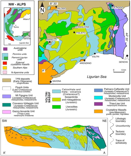
Among various mapped cases of landslides, we focused on the mountain slope deformation located in the Orba valley at about 25 km NW of Genova (), within the ultramafic terrains (serpentinite and peridotite) of the Voltri Massif (Capponi et al., Citation2016), near the village of Tiglieto (). We selected this structure because of its geologic complexity (e.g. movement evolving in two orthogonal directions, see below) and because it is located within the Beigua UNESCO Global Geopark, in an area of unique natural and historical value.
Figure 2. Geological sketch map of the Voltri Massif with location of the study area (red box).
The geomorphologic structure described in this work, was reported for the first time in one abstract by CitationFederico et al. (Citation2012) but never reported in databases and/or maps for the national land planning and management, e.g.; the Italian Landslides Inventory (‘Inventario dei Fenomeni Franosi Italiani’ https://www.progettoiffi.isprambiente.it/) of the Italian National Institute for Environmental Protection and Research, the Geo-hydrological risk reduction Master Plan (‘Piano per l’Assetto Idrogeologico del F. Po’ 2018 https://www.regione.liguria.it/open-data/item/7122-piano-assetto-idrogeologico-pai-del-fiume-po-dissesti-e-vincoli.html) and in the Unstable slope villages project (‘Atlante dei Centri Abitati Instabili’, 2004).
The aim of this paper is to illustrate the geological, tectonic and geomorphological features of the sagging-type mountain slope deformation (hereafter ‘Bianchina-Badia’) that involve the whole mountain ridge, the watershed and the valley floor system and influenced also the drainage network. We prepared detailed geological-geomorphological and morpho-tectonic GIS-based maps at 1:10,000 scale, with a geo-structural database, and 3D-models based also on interpretative geologic cross-sections. This work, grounded on detailed and combined structural and geomorphological analyses in the field, once again highlights the importance of ground truth observations and represents a recommended basis for further investigations (e.g. InSAR techniques).
2. Geological setting
The investigated area falls in the metaophiolitic Voltri Massif that belongs to the Ligurian-Piemontese units of the Western Alps (). The bedrock consists of various lithologies from the metaophiolite of the Voltri Unit (Capponi et al., Citation2016; Capponi & Crispini, Citation2008a, Citation2008b; Federico et al., Citation2005), i.e. serpentinite, with minor peridotite and lenses of eclogitic metabasite and metagabbro (see Geological and geomorphological Map in the ‘Main Map’ supplementary content). Serpentinite is by far the most abundant lithology and its texture ranges from massive to schistose (Capponi, Crispini, & Federico, Citation2013; Capponi, Crispini, & Piazza, Citation2013a, Citation2013b). At places, the metaophiolites are unconformably overlain by upper Eocene-lower Oligocene clastic sedimentary rocks of the episutural basin Tertiary Piedmont Basin (TPB; e.g. Gelati & Gnaccolini, Citation1988).
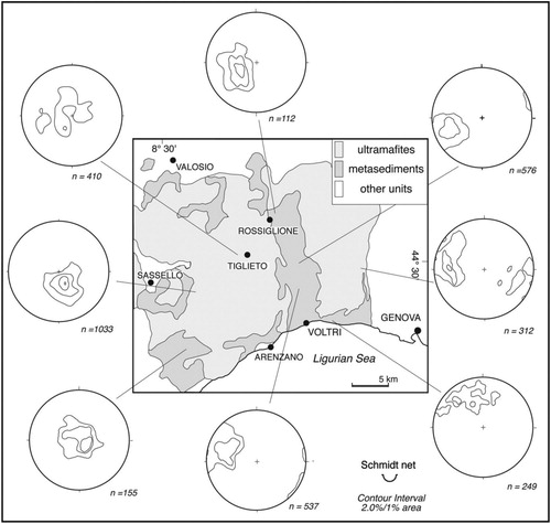
The Voltri Unit lithologies display a Composite fabric (CF) or regional schistosity resulting from at least two transpositive metamorphic folding events (F1 and F2-folds; Capponi & Crispini, Citation2002, Citation2008b). In the Tiglieto domain (), CF orientation ranges from subhorizontal to shallow dipping to NE (). CF is gently folded by meter-scale open folds, with axial surfaces moderately dipping to W–NW (F3 folds; Capponi & Crispini, Citation2002; Capponi, Crispini, & Piazza, Citation2013a).
Figure 3. Synoptic map showing the orientation of the composite fabric (CF) in different domains of the Voltri Massif (redrawn and modified after Capponi & Crispini, Citation2002).
All the ductile structures (including folds and CF) are truncated by thrust surfaces pertaining to a well-known late-orogenic Oligo-Miocene tectonic system which affects the Ligurian Alps and locally caused also the overlap of alpine metamorphic basement onto the younger TPB sediments (e.g. Capponi & Crispini, Citation2002; Crispini et al., Citation2009; Federico et al., Citation2008; Piana et al., Citation1997; Spagnolo et al., Citation2007). In the western sector of the Voltri Massif, the tectonic vergence of late folds and thrusts is top to the east-northeast, and these structures have been associated to a regional E–W striking sinistral strike-slip fault zone (Federico et al., Citation2014). In literature the Oligo-Miocene backthrust to E–NE of the metamorphic units of the Ligurian Alps is linked to the Corsica-Sardinia rotation and the related opening of the Ligurian-Provençal Basin (e.g. Alvarez et al., Citation1974; Argnani, Citation2012).
From the late Miocene onwards, the Tyrrhenian basin started to open (Kastens et al., Citation1988 and references therein) and since Pliocene the area of the gulf of Genova progressively acquired its present morphology. The uplift of the Ligurian Alps, with a rapid deepening of the Ligurian Sea, plus the development of E–W and N–S or NNW–SSE striking fault systems (limiting graben/pull apart basins) were associated to the rifting phase of the Tyrrhenian basin (; Marini, Citation1984 and references therein). INGV Seismological Data Centre (Citation2006).
Figure 4. Neotectonic sketch map (based on the Neotectonic map at 1:100,000 scale by Fanucci et al., Citation1982 and the INGV Seismological Data Centre, Citation2006). Legend: (1) relative tectonic uplift; (2) absolute tectonic uplift; (3) direction of tectonic movements (e.g. subsidence-stationary-uplift); (4) relative subsidence; (5) differential tectonic uplift, the arrow shows the lowest area; (6) normal fault; (7) tectonic lineation; (8) shallow-focus (0–15 km) and Richter local magnitude ML < 3.5 earthquake in the 1982–2014 period.
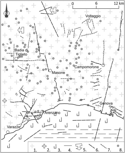
The uplift of the Ligurian coastal area has been continuing during all the Pleistocene with various tectonic pulses along normal and listric faults, active either along the southern slope of the Ligurian Alps either along the coast and the continental margin (Fanucci, Citation1986; Fanucci et al., Citation1982). The uplift was associated to a regional tilting to the north that produced a relevant asymmetry between the gentle northern slope and the steep southern slope of the Ligurian Alps (Lorenz, Citation1984). The neotectonic map at 1:100,000 scale by CitationFanucci et al. (Citation1982) reports two regional scale tectonic lineaments striking E–W and N–S, that cut through the study area ().
The present day (from 1982 to present) seismic activity in the study area (high Orba Valley) is characterized by a number of shallow earthquakes (0–15 km) with magnitude (ML) < 3 (; from the catalogue of the ‘Regional Seismic Network of Northwestern Italy’ http://www.distav.unige.it/rsni/). Historical events have been documented in the whole Liguria region (Boschi et al., Citation2000): in particular two large (ML > 5) earthquakes occurred close to the study area in 1767 (high Stura Valley) and 1276 (middle Tanaro Valley).
3. Methods
A detailed structural and geomorphological fieldwork was realized in the study area (about 5 km2) that is delimited by the Orba River to the N, S and E and by Mt. Laione and Bric delle Rocche to the W (see the Geological-geomorphological map in the Main Map, supplementary content). Field observations revealed the occurrence of numerous damage fault zones and volumes of fractured rocks, gravity related landforms, running waters and slope movement indicators such as tilted trees and damaged buildings.
Fieldwork was integrated with photo interpretation of multi-temporal aerial images (1954 flight of Italian Military Geographical Institute at 1:55,000 scale and 1995 Flight 13 of Liguria Region at 1:13,000 scale).
For geomorphological remote analysis we used CAD/GIS software packages (e.g. ESRI ArcGIS) with a digital terrain model (DTM) with a 5 m pixel resolution (Geoportale Regione Liguria – https://geoportal.regione.liguria.it).
We prepared a geo-referenced contour map in a vector format obtained from the contour lines derived from the regional technical map (1:5000) with 5 m pixel resolution; from this DTM, a shaded relief map, used as base for the Morpho-tectonic map at 1:10,000 scale (see inset in the Main Map, supplementary content), has been derived. From the DTM we also obtained, by means of GIS-based morphometric analysis, the slope map, the slope aspect map and the elevation map at 1:25,000 scale (see insets in the Main Map, supplementary content).
We also performed a critical review of previous geological and geomorphological studies in this area (both the scientific ones and those devoted to land planning and management): although they outlined gravitative landforms, processes and deposits, they don’t frame them in a more general context (e.g. Italian Landslides Inventory at https://www.progettoiffi.isprambiente.it/). The collection of literature data involved historical mentions of landslides, from archive documents, online catalogues and oral interviews of local people.
With the integration of the field data with the described remote analyses we organized the geological, geomorphological and morpho-tectonic maps at 1:10,000 scale and the 3D models of the mountain slope deformation.
4. Geological and geomorphological survey
4.1. Geology
The north-facing slope of the investigated area is characterized by a very low outcrop percentage (ca. 5–10%; see Geological-geomorphological Map in the Main Map) and exposed bedrock is mainly composed of serpentinite, metabasalt/gabbro and fine grained eclogite. Peridotite and serpentinite crop out almost continuously in the western sector of the study area (SSE and NE), both in steep reliefs and deeply incised valleys. The south-facing slopes are characterized by upper steeper parts with large outcrops of cataclastic serpentinite and by a lower gentle parts with very limited exposure of bedrock.
Serpentinite and peridotite are the prevalent exposed lithologies of the study area (). Serpentinite is either massive, with textural relicts of the original peridotite, or schistose, locally with cataclastic texture. The regional schistosity (CF) is mostly oriented either N–S or E–W with various angles of inclination due to the occurrence of multiple folding phases. In the study area, F1 and F2 folds are non-cylindrical, with axes scattered on the NNE–SSW axial surface. F3 folds are gentle to open, meter-scale folds, with axial surfaces moderately dipping to W–NW and roughly E–W trending axes. F3 folds do not have axial plane schistosity and are associated to low angle normal and reverse faults.
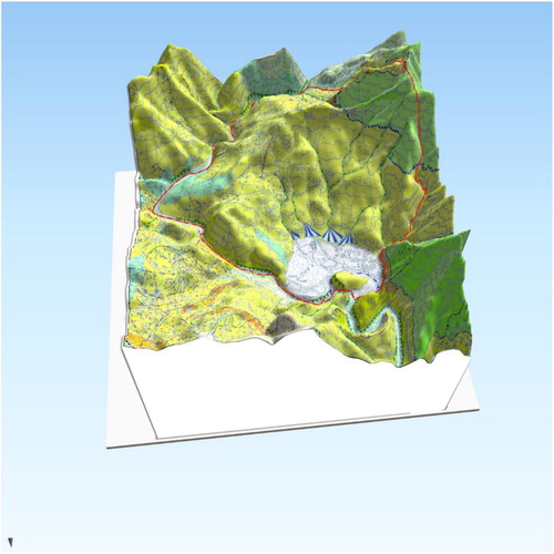
Figure 5. 3D-block diagram of the study area based on the geologic and geomorphologic map (perspective view is to the south). The 3D model has been obtained draping the main map of this study over the Digital Terrain Model (Geoportale Regione Liguria – https://geoportal.regione.liguria.it).
Serpentinite locally contains 10–100-m bodies or lenses of greenschist-facies metabasite or eclogite flattened along the regional fabric. Usually, at the contact between serpentinite and the mafic bodies bands of chlorite-actinolite-talc schists (m- to 10 m-wide) are present.
Peridotite is mainly lherzolite with preserved relics of the mantle tectonitic fabric. Peridotite occurs at the top of serpentinite along thrust surfaces (see Geological and geomorphological Map in the Main Map, supplementary content) that crop out on the E–W trending ridge in the south-western part of the Map (Mt. Laione – Bianchina village ridge) and on the ridge facing it to the northwest. The thrust faults are accompanied by 1–10 m-thick damage zones with highly fractured peridotites and serpentinites.
The study area is characterized by two main sets of faults (see inset in the Main Map, supplementary content) striking NE–SW and WNW–ESE. The NE–SW-striking are mainly tear faults associated to the thrust system which are characterized by decameter thick layers of fault rock as well.
The most steeply-dipping (>45°) measured faults have been selected and represented on rose diagrams field (see the rose diagrams in the Main Map) in order to make a comparison with the tectonic lineaments identified through photo interpretation. Selected tectonic lineaments show a mostly straight geometry (see Morpho-tectonic map in the Main Map) so that they can likely be referred to highly-dipping faults/fractures (Jordan et al., Citation2005 and references therein). The rose diagram of tectonic lineaments shows two maxima, either NE–SW or NW–SE striking, which fits with a good approximation the fault orientations measured in the field (see the rose diagrams in the Main Map).
Another fault system, roughly E–W striking (also reported as normal fault system by Federico et al., Citation2014), apparently controls the partially collapsed M. Laione – Bianchina village ridge (see Morphotectonic Map).
4.2. Geomorphology
The Geomorphological and morphotectonic features were obtained through field surveys, photo interpretation and processing of the Digital Terrain Model with a 5 m pixel resolution.
The morphology of the studied area, despite the lithological homogeneity represented mainly by serpentines and subordinates peridotite, shows three zones with different slope gradient, in details: (i) a large flat area, at an average elevation of 380 m a.s.l., corresponding to the ‘Piana della Badia’; (ii) steep slopes, often exceeding 45°, along the western sector of the studied area, up to 700 m a.s.l.; (iii) gently slopes generally contained within 25° but often less than 20° which characterize almost the whole studied area between 380 and 600 m a.s.l.
The origin of the ‘Piana della Badia’ can be associated to the occurrence of alluvial and fluvio-lacustrine deposits, with thicknesses within 10 m: the presence in the deposits stratigraphy of fine grained soils with an organic fraction point to a partial a damming effect by landslides of the Orba River (Federico et al., Citation2012). The western steep slopes of the study area are mainly characterized by ultramafic bedrock, whereas the more gentle slopes show thick debris deposits. In detail, these slopes featured a step-like morphology profile with alternating small flat areas and others with steeper gradient.
In the field we identified mainly tectonic and gravitational landforms and subordinated running water and man-made (or anthropic) forms. In the mid-upper parts of the slope, between Acquabona, Bianchina and Scuria villages, several morpho-structural elements (see Morpho-tectonic map in the Main Map) were observed, including linear ridges, plano-altimetric ridge discontinuities, saddles.
Some small trenches, filled with fine-size sediments, are present close to the watershed.
In the lower-medium parts of the slopes, facing towards N, S and E, a succession of scarps and counter scarps are highlighted in the ‘Slope map’ and ‘Slope aspect map’ (see Main Map, supplementary content). On the slope between the villages of Acquabona and Bianchina and the ‘Piana della Badia’, closed depressions sporadically occupied by ponds, have been recognized and mapped.
Numerous landslide bodies with different kinematics and state of activity were identified in the study area (see Main Map, supplementary content); see for example the complex-type active and inactive landslides at the village of Casavecchia (east of the Orba River in the north of the study area), the large rockfall form a high scarp affecting the western sector of ‘Piana della Badia’ (which probably temporarily dammed the course of the Orba river), and other complex landslides insisting on the villages of Casabona, Bianchina and Cascinetta (in the southern study area).
The state of activity of the mapped landslides has been evaluated through indirect kinematic indicators, i.e.: bending and tilting of trees trunks, tension cracks along the road pavements and on the buildings. The active landslides show extremely slow displacement rates.
Fluvial landforms and running water phenomena have been also identified and they indicate that both the main (Orba river) and minor (left side tributaries) hydrographic networks are undergoing active erosion.
The angular geometry of the main drainage pattern characterized by straight river reaches, stream elbows, counterflows confluences along the main river with NE–SW, NW–SE and minor N-S and E-W directions, suggests to be controlled by tectonic structures of the bedrock. The main faults (tectonic lineaments) of the study area may have been repeatedly reactivated until recent times (see Geologic setting), defining and shaping the main step-like morphology and landscape.
One further relevant observation can be made concerning anthropic landforms and research from historical archives. Although nowadays the study area have few small inhabited villages within a wooded hillside, in the past, for at least 1000 years, the Monks who settled the Abbey of Tiglieto influenced the surrounding natural environment. Their activities included (Federico et al., Citation2012): (i) the Badia floodplain, originally a swamp, was subjected to intense land reclamation by a dense canal network; (ii) the north-facing slope has been modified with the realization of man-made terraces, mainly in the area behind the religious complex with a resulting change in land uses; (iii) clay pits for raw materials used in local constructions, were excavated along the floodplain, as also suggested by few placenames (e.g. ‘Furnace’ stream); (iv) some watercourses have been diverted, including the Orba stream (the ‘cut of the Ruta’), either for flood risks reduction or water resources management.
5. A mountain slope deformation in ophiolite rock masses
On the basis of our results from the integration of structural and geomorphological field survey, photo interpretation and GIS-based multiple analysis, we identified a large Mountain Slope Deformation (sensu Hungr et al., Citation2014, or DsGSD) () that involve the study area between: (a) the floodplain to the north; (b) the villages of Acquabona and Bianchina to the south; (c) the left bank of Orba River to East; (d) the Mt. Laione – Bric delle Rocche ridge to West. The inferred area of the slope deformation is about 5 km2 (see Main Map, supplementary contents).
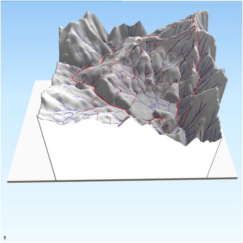
Figure 6. 3D-block diagram of the study area based on the morpho-tectonic map (perspective view is to the south). The 3D model has been obtained draping the morpho-tectonic map of this study over the Digital Elevation Model (Geoportale Regione Liguria – https://geoportal.regione.liguria.it).
In the area between the E–W trending local watershed (Mt. Laione – Bianchina village rigde), at 500–600 m a.s.l., and the Orba riverbed, outcrops of bedrocks are extremely rare and they are mostly represented by rock blocks of heterogeneous size. Here for the first time, we identified and mapped the typical morphological evidence of slope deformations, such as trenches, double ridges, closed depressions and counter scarps (see Morpho-tectonic map in the Main Map).
The main and the secondary hydrographic networks show angular geometry following two main NE–SW and NW–SE directions. These trends match those of tectonic lineaments from photo interpretation and two main fault sets measured in the field. The NE–SW and NW–SE trending faults, coupled with a secondary E–W fault set, gave rise to a system of tectonic blocks that controlled the slope evolution.
The slopes in the study area show a ‘step-like’ profile, typical of sackungs, characterized by flat areas, alternating with scarps and counter scarps (). Some of these flat areas, associated with trenches, can be found also along the ridge (i.e. around Bianchina village): therefore, the ridge itself is at least partially collapsed. Scarps are mostly (more than 60%) facing towards the north (or NE and NW), secondly to the E-SE and lesser to the south.
Figure 7. Morphological cross section along the ‘Bianchina-Badia’ mountain slope deformation. Profiles emphasize the step-like profile of the slope and typical morphological evidence of slope deformations, such as trenches, double ridges, closed depressions and counter scarps. The vertical scale is 3-times exaggerated.
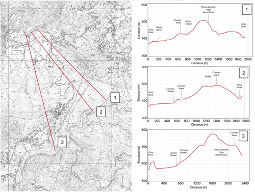
A reference model for our geomorphological feature is not easily defined: it could be described as a double-sagging type of CitationHutchinson (Citation1988), even if a complex sagging or a slopes deformation (Hungr et al., Citation2014) is probably the most appropriate definition, since the slopes clearly collapsed in the three different orientations N, S and E, also following the Orba River path ( and Geologic Cross-sections in the Main Map).
No direct age dating of the ‘Bianchina-Badia’ slope deformation is available; however, about 9 km to the SSW from the study area, at the bottom of a swampy deposit (‘Torbiera del Laione’), an age of 10,840 B.P. has been obtained for the infill of a trench at the top of a similar mountain slope deformation (Guido et al., Citation2004). This age corresponds to the Pleistocene – Holocene transition, a period characterized by remarkable climate changes (i.e. alternation of cold and warm periods) in the Ligurian Alps, and is in good agreement with the ages of other similar phenomena both in the Alps (Agliardi et al., Citation2001; Jaboyedoff, Citation2011; Jomard et al., Citation2014) and in the Apennines (Faccini et al., Citation2009; Faccini et al., Citation2013).
Our results allowed us to identify typical causal factors for the ‘Bianchina-Badia’ mountain slope deformation.
In particular, the geological and tectonic setting of the area played a major role in triggering instability; lithologies with a significant difference in rock strengths are spatially associated (Fioraso et al., Citation2019; Hermann et al., Citation2000; Jaboyedoff, Citation2011; Jaboyedoff et al., Citation2013; Martinotti et al., Citation2012), namely ‘hard-rock’ peridotite lies on top of weak foliated, fractured and weathered serpentinite.
The major triggering factor was probably the Plio-Pleistocene tectonic history of the study area. This is linked to the uplift of the Ligurian Alps that was accompanied by the development and reactivation of normal faults (Fanucci et al., Citation1982; Sacchini et al., Citation2016a; Sacchini et al., Citation2016b). In the study area significant relative vertical movements may be confirmed by the presence of ancient alluvial deposits at about 450 m a.s.l. (see Geological-geomorphological Map in the Main Map).
Even if no direct age dating are available, we identified a relative time sequence of brittle tectonic structures and events: (a) top to east thrusts and NE–SW-striking tear faults attributable to the Oligo-Miocene regional event (see Federico et al., Citation2014 and ref. therein); they made the general geological framework; (b) E–W, NW–SE and NE–SW-striking fault systems, likely related to a neotectonic event (Federico et al., Citation2014). The latter fault systems and the occurrence of large volume of fractured and weathered serpentinite triggered the collapse of the slopes.
In this geo-tectonic framework, climate changes also played an important role in the Mountain Slope Deformation evolution: in particular, the alternating Quaternary cold and warm cycles (due to the glacial and interglacial phases) induced sea level fluctuations and, as a consequence, variations of the rivers base level. This led to periodic rejuvenation of relief (the whole river network shows evidence of active erosion) that in turn facilitated the action of exogenous agents, such as gravity, running water, ice/snow. In particular, the periglacial processes enhanced weathering and rock degradation.
The peculiar position of the ‘Bianchina-Badia’ Mountain Slope Deformation that is close to the Tyrrhenian-Po river watershed may be related to the relief inversion due to the northward migration of the watershed during the tilting of the Ligurian Alps (Lorenz, Citation1984); this process probably caused changes in the rivers base level, interruptions in the river network and, as a consequence, strong slope disequilibrium.
6. Conclusions and future developments
We identified and mapped a new mountain slope deformation (‘Bianchina-Badia DsGSD’) that involves a ca 5 km2 area in the Ligurian Alps (upper Orba Valley, ca. 16 km NW of Genova), along the Tyrrhenian-Po river watershed.
This slope deformation can be classified as a complex-sagging-type since it collapsed in three different orientations (about N, S and E) and involves, at least partially, the watershed.
Several factors triggered the development of the ‘Bianchina-Badia’ Mountain Slope Deformation, including: (i) the association of lithologies with a significant difference in rock strengths, namely ‘hard-rock’ peridotite that lies on top of weak foliated, fractured and weathered serpentinite; (ii) a complex structural setting dominated by three (NE–SW, NW–SE and E–W striking) fault systems that clearly influence the morphostructural landscape of the area; (iii) the Plio-Pleistocene tectonic uplift of the Ligurian Alps and (iv) the Quaternary alternating glacial and interglacial phases that induced sea level fluctuations and as a consequence variations of the rivers base level and periodic rejuvenation of relief. Further improvement to this research will come from SAR images analyses and a reflection seismic survey that will investigate depths in the order of 100 m, as recommended by CitationFaccini et al. (Citation2013): this would allow to define a reliable geological-engineering and hydrogeological model for this deformation.
This study once again highlights the importance of ground truth observations as the basis for further investigations. Through the integration of geological-geomorphological mapping, structural data, photo interpretation, GIS-based multiple analysis, we identified a number of typical Mountain Slope Deformations. Here we describe, as an example, one major complex-sagging-type deformation landforms that is not present in national land planning and/or management database but it can be considered at the origin of the large-scale landslides which affected the villages of the area. The ‘Bianchina-Badia’ slope deformation is also located within the Beigua UNESCO Global Geopark, in an area of unique natural and historical value.
During the fieldwork for geological mapping of central Liguria territory we identified numerous structures that can be classified as mountain slope deformations. These are concentrated near the Tyrrhenian – Po river watershed and affect mainly the metaophiolite of the Ligarian Alps (e.g. Voltri Massif or other minor metaophiolitic units). These findings are new for this area as they have not been evidenced before in the specific Italian databases. The extension and huge volume of rock masses involved in DsGSDs deserve future deep investigations and monitoring either for modelling the structural architecture of the area or for the land-use planning and geomorphological hazard.
Software
®Adobe Illustrator CS4 and ®Avenza MaPublisher 8.3.3 were used to draw the map. The morpho-tectonic map, the elevation map, the slope map and the slope aspect map have been drawn using the QGIS 3.0. The rose diagrams of faults and tectonic lineaments have been produced using OSXStereonet 1.9. The 3D models were made using the QGIS2THREEJS plugin in QGIS and the morphological cross-sections were drawn using the plugin Profile Tool in QGIS.
MountainSlopeDeformation_main_map_revised.pdf
Download PDF (23 MB)Acknowledgements
The authors wish to thank Chris Orton, Mihai Micu, Marco Materazzi and Alessandro Chelli for the useful comments provided throughout the revision of the manuscript and the maps.
Disclosure statement
No potential conflict of interest was reported by the author(s).
References
- Agliardi, F., Crosta, G., & Zanchi, A. (2001). Structural constraints on deep-seated slope deformation kinematics. Engineering Geology, 59(1–2), 83–102. https://doi.org/10.1016/S0013-7952(00)00066-1
- Alvarez, W., Cocozza, T., & Wezel, F. C. (1974). Fragmentation of the alpine orogenic belt by microplate dispersal. Nature, 248(5446), 309–314. https://doi.org/10.1038/248309a0
- Argnani, A. (2012). Plate motion and the evolution of alpine Corsica and Northern Apennines. Tectonophysics, 579, 207–219. https://doi.org/10.1016/j.tecto.2012.06.010
- Boschi, E., Guidoboni, E., Ferrari, G., Mariotti, D., Valensise, G., & Gasperini, P. (2000). Catalogue of strong Italian earthquakes from 461 B.C. to 1980. Annali di Geofisica, 43(4), 609–868. https://doi.org/10.4401/ag-3668
- Capponi, G., & Crispini, L. (2002). Structural and metamorphic signature of alpine tectonics in the Voltri Massif (Ligurian Alps, northwestern Italy). Eclogae Geologicae Helvetiae, 95, 31–42. ISSN:00129402.
- Capponi, G., & Crispini, L. (2008a). Foglio 213 – 230 “Genova” della Carta Geologica d’Italia alla scala 1:50.000 [213–230 “Genova” sheet of the Italian geological map at 1:50000 scale]. APAT – Regione Liguria, Selca.
- Capponi, G., & Crispini, L. (2008b). Note Illustrative del Foglio 213–230 «Genova» della Carta Geologica d’Italia alla scala 1:50.000 [Explanatory notes of the 213–230 “Genova” sheet of the Italian geological map at 1:50000 scale]. Apat-Regione Liguria, Selca.
- Capponi, G., Crispini, L., & Federico, L. (2013). Note Illustrative al Foglio 212 “Spigno Monferrato” della Carta Geologica Regionale della Liguria [Explanatory notes of the 212 “Spigno Monferrato” sheet of the regional geological map of Liguria]. http://www.cartografia.regione.liguria.it/apriFoglia.asp?itemID=30208&fogliaID=1579&label=Carta%20Geologica%20Regionale%20%28CGR%29%20sc.%201:25000%20riferita%20al%20Foglio%20212%20Spigno%20Monferrato%20-%20sc.%201:50000
- Capponi, G., Crispini, L., Federico, L., & Malatesta, C. (2016). Geology of the eastern Ligurian Alps: A review of the tectonic units. Italian Journal of Geosciences, 135(1), 157–169. https://doi.org/10.3301/IJG.2015.06
- Capponi, G., Crispini, L., & Piazza, M. (2013a). Foglio 212.1 “Tiglieto”, scala 1/25’000, Regione Liguria [212.1 “Tiglieto” sheet at 1/25000 scale of the regional geological map of Liguria]. http://www.regione.liguria.it/opendata/dati cartografici/item/37914-cartageologica-regionale-cgr-sc-125000-riferita-al foglio-212-spigno-monferrato-sc-150000.html
- Capponi, G., Crispini, L., & Piazza, M. (2013b). Sezione 212080 “Tiglieto”, scala 1/10’000, Regione Liguria [212080 “Tiglieto” section at 1/10000 scale of the regional geological map of Liguria]. http://www.cartografia.regione.liguria.it/apriFoglia.asp?itemID=30208&fogliaID=1575&label=Carta%20Geologica%20Regionale%20%28CGR%29%20sc.%201:10000%20riferita%20al%20Foglio%20212%20Spigno%20Monferrato%20-%20sc.%201:50000
- Carobene, L., & Cevasco, A. (2011). A large scale lateral spreading, its genesis and quaternary evolution in the coastal sector between Cogoleto and Varazze (Liguria – Italy). Geomorphology, 129(3–4), 398–411. https://doi.org/10.1016/j.geomorph.2011.03.006
- Crispini, L., Capponi, G., & Federico, L. (2009). Late orogenic transpressional tectonics in the «Ligurian knot». Italian Journal Geoscience, 128(2), 433–441. https://doi.org/10.3301/IJG.2009.128.2.433
- Crosta, G. (1996). Landslide, spreading, deep seated gravitational deformation: Analysis, examples, problems and proposals. Geografia Fisica e Dinamica Quaternaria, 19, 297–313.
- Crosta, G. B., & Zanchi, A. (2000, June). Deep-seated slope deformations. Huge, extraordinary, enigmatic phenomena. In E. Bromhead, N. Dixon, & M. Ibsen (Eds.), Landslides in research, theory and practice. Proceeding 8th international symposium on landslides, Cardiff (pp. 351–358). Thomas Telford.
- Dikau, R., Brunsden, D., Schrott, L., & Ibsen, M. (Eds.). (1996). Landslide recognition. Identification, movement and causes. Wiley.
- Dramis, F., & Sorriso-Valvo, M. (1994). Deep-seated gravitational slope deformations, related landslides and tectonics. Engineering Geology, 38(3–4), 231–243. https://doi.org/10.1016/0013-7952(94)90040-X
- Faccini, F., Piccazzo, M., & Robbiano, A. (2009). A deep-seated gravitational slope deformation in the Upper Bargonasco Valley (Ligurian Apennines). Geografia Fisica e Dinamica Quaternaria, 32(1), 73–82. ISSN:03919838.
- Faccini, F., Robbiano, A., Roccati, A., & Raso, E. (2013). Gravity-driven deep-reaching deformations and large-scale landslides in recently uplifted mountain areas: The case-study of Mt. Cucco and Belpiano (Ligurian Apennine, Italy). Italian Journal of Engineering Geology and Environment – Book Series, 6, 141–152. https://doi.org/10.4408/IJEGE.2013-06.B-11
- Fanucci, F. (1986). Evolution stratigraphique de la région du golfe de Gênes depuis l’Eocène Supérieur [Stratigraphic evolution of the Gulf of Genova region since Late Eocene]. Memorie della Societa Geologica Italiana, 36, 19–30.
- Fanucci, F., & Nosengo, S. (1977). Rapporti tra neotettonica e fenomeni morfogenetici del versante marittimo dell’Appennino ligure e del margine continentale [Relations between neotectonics and morphogenetic phenomena of the maritime slope of the Ligurian Apennines and the continental margin]. Bollettino della Società Geologica Italiana, 96, 41–51.
- Fanucci, F., Tedeschi, D., & Vignolo, A. (1982). Nuovi dati di neotettonica rilevati sul foglio 82 Genova. Contributi preliminari alla realizzazione della carta neotettonica d’Italia [New neotectonic data of the 82 Genova sheet. Preliminary contributions to the neotectonic map of Italy]. Pubbl. 356 del P.F. Geodinamica.
- Federico, L., Capponi, G., Crispini, L., Scambelluri, M., & Villa, I. M. (2005). 39Ar/40Ar dating of high-pressure rocks from the Ligurian Alps: Evidence for a continuous subduction–exhumation cycle. Earth and Planetary Science Letters, 240(3–4), 668–680. https://doi.org/10.1016/j.epsl.2005.09.062
- Federico, L., Crispini, L., Vigo, A., & Capponi, G. (2014). Unraveling polyphase brittle tectonics through multi-software fault-slip analysis: The case of the Voltri Unit, Western Alps (Italy). Journal of Structural Geology, 68, 175–193. https://doi.org/10.1016/j.jsg.2014.09.011
- Federico, L., Faccini, F., Torchio, S., Roccati, A., Crispini, L., Vigo, A., Poggi, E., Firpo, M., & Capponi, G. (2012). Deep seated gravitational slope deformation in an alpine Ophiolites Massif: The case of “Badia Di Tiglieto” (Voltri Massif, Northern Italy). Rendiconti Online Della Società Geologica Italiana, 22, 83–85. ISSN:20358008.
- Federico, L., Spagnolo, C., Crispini, L., & Capponi, G. (2008). Fault-slip analysis in the metaophiolites of the Voltri Massif: Constraints for the tectonic evolution at the Alps/Apennine boundary. Geological Journal, 44(2), 225–240. https://doi.org/10.1002/gj.1139
- Ferraris, F., Firpo, M., & Pazzaglia, F. J. (2012). DEM analyses and morphotectonic interpretation: The Plio-Quaternary evolution of the eastern Ligurian Alps, Italy. Geomorphology, 149–150, 27–40. https://doi.org/10.1016/j.geomorph.2012.01.009
- Fioraso, G. (2017). Impact of massive deep-seated rock slope failures on mountain valley morphology in the northern Cottian Alps (NW Italy). Journal of Maps, 13(2), 575–587. https://doi.org/10.1080/17445647.2017.1342211
- Fioraso, G., Balestro, G., Festa, A., & Lanteri, L. (2019). Role of structural inheritance in the gravitational deformation of the Monviso meta-ophiolite complex: The Pui-Orgiera serpentinite landslide (Varaita Valley, Western Alps). Journal of Maps, 15(2), 372–381. https://doi.org/10.1080/17445647.2019.1602854
- Gelati, R., & Gnaccolini, M. (1988). Sequenze deposizionali in un bacino episuturale, nella zona di raccordo tra. Atti Ticinesi di Scienze della Terra Alpi ed Appennino settentrionale, 31, 340–350.
- Giammarino, S., Capponi, G., Crispini, L., Giglia, G., & Piazza, M. (2002). Carta Geologica della LIGURIA – Scala 1: 200.000. LAC (Firenze). https://doi.org/10.13140/RG.2.2.14791.50081
- Guido, M. A., Mariotti Lippi, M., Menozzi, B. I., Placereani, S., & Montanari, C. (2004). Il paesaggio vegetale montano della Liguria centro-occidentale nell’età del Ferro: area del monte Beigua (Savona) [Mountain green landscape of central-western Liguria during the Iron Age: Mount Beigua area (Savona)]. In R. C. de Marinis & G. Spadea (Eds.), I Liguri, un antico popolo europeo tra Alpi e Mediterraneo. Skira ed.
- Hermann, S. W., Madritsch, G., Rauth, H., & Becker, L. P. (2000). Modes and structural conditions of large scale mass movements (Sackungen) on crystalline basement units of the Eastern Alps (Niedere Tauern, Austria. Mitteilungen des Naturwissenschaftlichen Vereines für Steiermark, 130, 31–42.
- Hungr, O., Leroueil, S., & Picarelli, L. (2014). The Varnes classification of landslide types, an update. Landslides, 11(2), 167–194. https://doi.org/10.1007/s10346-013-0436-y
- Hutchinson, J. N. (1988). General report. Morphological and geotechnical parameters of landslides in relation to geology and hydrogeology. In Proceedings 5th international symposium on landslides, Lausanne (Vol. 1, pp. 3–35).
- INGV Seismological Data Centre. (2006, January 1). Rete Sismica Nazionale (RSN). Istituto Nazionale di Geofisica e Vulcanologia (INGV), Italy. https://doi.org/10.13127/SD/X0FXNH7QFY
- Jaboyedoff, M. (2011). Slope tectonics. Geological society, special publications n° 351.
- Jaboyedoff, M., Penna, I., Pedrazzini, A., Baron, I., & Crosta, G. B. (2013). An introductory review on gravitational-deformation induced structures, fabrics and modeling. Tectonophysics, 605, 1–12. https://doi.org/10.1016/j.tecto.2013.06.027
- Jomard, H., Lebourg, T., & Guglielmi, Y. (2014). Morphological analysis of deep-seated gravitational slope deformation (DSGSD) in the western part of the Argentera massif. A morpho-tectonic control? Landslides, 11(1), 107–117. https://doi.org/10.1007/s10346-013-0434-0
- Jordan, G., Meijninger, B. M. L., Van Hinsbergen, D. J. J., Meulenkamp, J. E., & Van Dijk, P. M. (2005). Extraction of morphotectonic features from DEMs: Development and applications for study areas in Hungary and NW Greece. International Journal of Applied Earth Observation and Geoinformation, 7(3), 163–182. https://doi.org/10.1016/j.jag.2005.03.003
- Kastens, K., Mascle, J., Auroux, C., Bonatti, E., Broglia, C., Channell, J., Curzi, P., Emeis, K.-C., Glaçon, G., Hasegawa, S., Hieke, W., Mascle, G., Mccoy, F., Mckenzie, J., Mendelson, J., Müller, C., Réhault, J.-P., Robertson, A., Sartori, R., … Torii, M. (1988). ODP leg 107 in the Tyrrhenian Sea: Insights into passive margin and back-arc basin evolution. Geological Society of America Bulletin, 100(7), 1140–1156. https://doi.org/10.1130/0016-7606(1988)100<1140:OLITTS>2.3.CO;2
- Lorenz, C. (1984). Evolution stratigraphique et structurale des Alpes Ligures depuis l’Eocène Superieur. Memorie della Societa Geologica Italiana, 28, 211–228.
- Marini, M. (1984). Le deformazioni fragili del Pliocene Ligure: implicazioni nella Geodinamica Alpina [Brittle deformations of Ligurian Pliocene: Implications for alpine geodynamics]. Memorie della Societa Geologica Italiana, 29, 157–169.
- Martinotti, G., Giordan, D., Giardino, M., & Ratto, S. (2012). Controlling factors for deep-seated gravitational slope deformation (DSGSD) in the Aosta Valley (NW Alps, Italy). In M. Jaboyedoff (Ed.), Slope tectonics (Special publications, 351, pp. 113–131). Geological Society. https://doi.org/10.1144/SP351.6
- Mortara, G., & Sorzana, P. F. (1987). Fenomeni di deformazione gravitativa profonda nell’Arco Alpino Occidentale Italiano. Considerazioni lito-strutturali e morfologiche [Deep-seated gravitational slope deformations in the Western Italian Alps. Litho-structural and morphological considerations]. Bollettino della Società Geologica Italiana e del Servizio Geologico d’Italia, 106, 303–314.
- Piana, F., D’atri, A., & Orione, P. (1997). The Visone formation: A marker for the Early Miocene tectonics in the Alto Monferrato domain (Tertiary Piemonte Basin, NW, Italy). Memorie Scienze Geologiche Università Padova, 49, 145–162.
- Sacchini, A., Faccini, F., Ferraris, F., Firpo, M., & Angelini, S. (2016a). Large-scale landslide and deep-seated gravitational slope deformation of the Upper Scrivia Valley (Northern Apennine, Italy). Journal of Maps, 1021393. https://doi.org/10.1080/17445647.2015.1021393
- Sacchini, A., Faccini, F., & Luino, F. (2016b). Deep seated gravitational slope deformations in a Ligurian Apennines catchment (Italy): Evidences, characterizations and consequences. Disaster Advances, 9(3), 1–18. ISSN:0974262X.
- Sanchez, G., Rolland, Y., Corsini, M., Braucher, R., Bourlès, D., Arnold, M., & Aumaître, G. (2010). Relationships between tectonics, slope instability and climate change: Cosmic ray exposure dating of active faults, landslides and glacial surfaces in the SW Alps. Geomorphology, 117(1–2), 1–13. https://doi.org/10.1016/j.geomorph.2009.10.019
- Spagnolo, C., Crispini, L., & Capponi, G. (2007). Late structural evolution in an accretionary wedge: Insights from the Voltri Massif (Ligurian Alps, Italy). Geodinamica Acta, 20(1–2), 21–35. https://doi.org/10.3166/ga.20.21-35
- Spagnolo, M., & Firpo, M. (2007). Geomorphic evolution of the seaward escarpment in the NE Ligurian Alps (Italy). Zeitschrift für Geomorphologie, 51(1), 115–134. https://doi.org/10.1127/0372-8854/2007/0051-0115