
ABSTRACT
In this paper we present geomorphological hazard mapping of the San Vito Peninsula offshore (Sicilian margin of Tyrrhenian Sea), characterised by a very narrow continental shelf and a very dipping, tectonically active continental slope, no far from a seismogenic belt. The data set consists of morpho-bathymetric models achieved by means of multibeam survey and scattered high resolution seismic profiles. The morpho-bathymetric study highlighted some potential sites of geomorphological hazards, the most representative of which are: (i) two canyons developing from the upper slope off San Vito Cape down to the Erice basin; (ii) a dense network of small incisions across the upper slope; (iii) a very active landslide, developed onland and extending in the continental shelf close to the Scopello village. The geomorphological features that can generate submarine hazard are represented by: unstable sediment packages into canyon heads or along the upper slope; submarine canyons with regressive erosion; coastal landslides.
1. Introduction
Marine geo-hazards are geological conditions at the sea floor or within sub-bottom sediments that could result in dangerous or catastrophic events with attendant risks to life and/or infrastructure. Examples of such hazards include earthquakes and submarine landslides that can directly impact on coastal areas and/or offshore infrastructures or that can trigger tsunamis (CitationInternational Centre for Geohazards, 2003).
Over the past decades, marine geological risks have received increasing attention from the international scientific community following both the occurrence of natural catastrophic events (e.g. the 2004 Indian Ocean and 2011 Japan tsunamis; CitationBrink et al., Citation2009; CitationRabinovich et al., Citation2015; CitationSatake et al., Citation2007, Citation2013) and the intensification of anthropic activities in offshore areas, which necessarily have to deal with the geological hazards occurring in these areas.
At the same time, recent development of marine geophysical surveys has greatly improved our capability of identifying marine geo-hazards. Seafloor imaging and mapping techniques have clearly highlighted the widespread distribution of slope failures along the seafloor, where the seabed instability represents the main cause of geological hazards (CitationChiocci et al., Citation2011). Marine geo-hazards encompasses geological processes and features that originate from the recent-to-current morpho-sedimentary dynamics (CitationCasalbore et al., Citation2011) as well as the long-term geological evolution of the continental margins. In addition to geomorphological features related to gravitational mass movements, as landslide scars and deposits, and headscarps and erosional flanks of canyons (CitationArgnani et al., Citation2011; CitationCanals et al., Citation2004; CitationLo Iacono et al., Citation2011, Citation2014; CitationL’Heureux et al., Citation2011; CitationYamada et al., Citation2012) also mud volcanoes, pockmarks (CitationYun et al., Citation1999) fault-related seafloor roughness (CitationLarroque et al., Citation2011) and sediment transport bedforms (CitationChiocci et al., Citation1996; CitationUrgeles et al., Citation2011) are representative of seabed instability and they can be regarded as geo-hazard indicators (CitationMorelli et al., Citation2011; CitationNielsen & Kuijpers, Citation2004).
Geological-geomorphological mapping represents a fundamental tool to assess marine geo-hazards (CitationChiocci & Ridente, Citation2011; CitationHough et al., Citation2011; CitationLeón & Somoza, Citation2011; CitationStrasser et al., Citation2011); marine geology studies provide critical information about the modern stability of the seabed, reveal evidence of past instability and divulge specific constraints around the timing and triggering of past events, thus improving predictive capability for future events.
The purpose of marine geohazard evaluation is to provide solid scientific bases for planning choices and decisions in planning settlements, infrastructures and human activities along the coastal belt and in offshore areas (CitationInternational Society for Soil Mechanics and Geotechnical Engineering, Citation2005).
This paper illustrates the potential marine geo-hazards detected in the San Vito peninsula offshore (northern Sicily coast, southern Tyrrhenian Sea), where a number of different-size slope failure affect the upper slope, revealing extensive and frequent mass wasting sedimentary processes. Our analysis is based on the interpretation of high-resolution multibeam bathymetry, side scan sonar imaging, high resolution seismic profiles and on the production of a map imaging the geohazard-related geomorphic features.
2. Geological setting
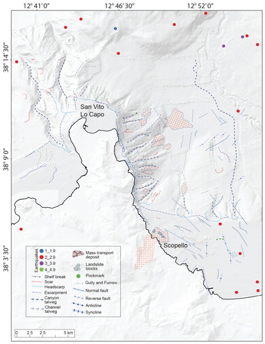
The study area is located in the north-western Sicily continental margin (). The geological evolution of this region recorded the consequences of Africa-Europe convergence that caused continental collision since Middle Miocene (CitationCatalano et al., Citation2013). In this setting, the relief of the San Vito peninsula, up to 1100 m high (Mount Sparagio) is marked by the overthrust of Meso-Cenozoic carbonate rocks over Tertiary silico-clastic deposits (see structural sketch in Main Map; CitationCatalano et al., Citation2011). Since the Late Pliocene, the shortened and thickened continental crust of the orogenic belt was affected by trastensional tectonic and subsidence related to Tyrrhenian Sea opening (CitationKastens et al., Citation1988), but both geodynamic convergence and compressional tectonics are still occurring (CitationAgate et al., Citation1993) as documented by GPS measurements and seismic activity (; CitationAgate et al., Citation2000; CitationDevoti et al., Citation2008). Although the Capo San Vito offshore is affected by a relevant network of active faults, it is currently affected by a recurrent low intensity seismicity located in the shallow crust (CitationPondrelli & Salimbeni, Citation2006); the epicentres of earthquakes with a greater magnitude are mostly located between the northern Sicily and the island of Ustica.
Figure 1. Location map showing the physiography of the study area along the north-western Sicily margin.
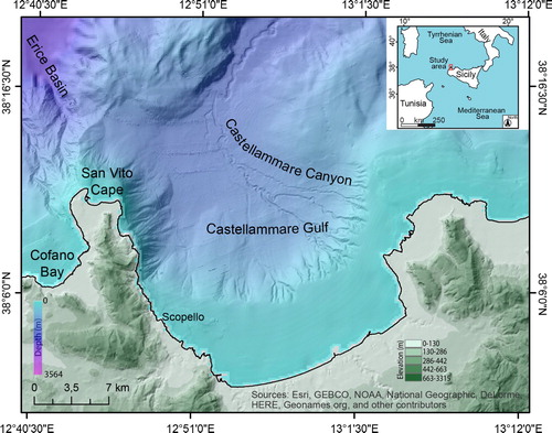
Figure 2. Map showing distribution of epicentres across the study area and the main geomorphological features.
The San Vito peninsula was affected by moderate tectonic uplift during the middle-late Pleistocene. (CitationAntonioli et al., Citation1998; CitationDi Maggio et al., Citation1999; CitationMauz et al., Citation1997). Littoral deposits dated to ‘Tyrrhenian’ age (isotopic Oxygen sub-stage 5e; CitationRuggieri et al., Citation1968) overlay a marine abrasion surface located at 18 m a.s.l. in the Piana di Castelluzzo.
An average uplift rate of 0.11–0.14 mm/yr since MIS 15–13 has been estimated by CitationDi Maggio et al. (Citation1999), that slowed down to 0.05–0.06 mm/yr since MIS 5.5 according to CitationFerranti et al. (Citation2006).
Cyclic middle-late Quaternary glacio-eustatic changes influenced depositional and erosional processes along the margin. The San Vito peninsula shows a high relief energy; as consequence all along its eastern escarpments, landslides as rotational sliding, lateral spread, block slide occur, as well as surface gravitational processes affecting mostly clay-marly deposits (CitationAgnesi et al., Citation1987; CitationDi Maggio et al., Citation2014).
The combined result of tectonic-eustatic-sedimentary evolution is the present-day offshore physiography that includes areas of continental shelf and upper slope characterised by a very immature evolutionary stage (CitationAgate et al., Citation2002; CitationWezel et al., Citation1981). As matter of fact the continental shelf surrounding the peninsula is very narrow (width between 1 and 8 km) and shows an uneven seabed morphology; the upper continental slope is up to 12° dip and it deepens to the depth of about 1000 m where intraslope basinal areas extend (CitationAgate et al., Citation1993). The shelf break is deep between 55 and 170 m, and at places it is indented by canyons and furrows headscarps (see Main Map). The coast is mostly eroding with prevailing cliffs and headlands alternating to small pocket beaches.
The upper slope setting is mainly the result of Pleistocene sedimentary progradation, mostly nourished by sediment supply coming from scattered entry points along the coastline. The Pleistocene succession is thick up to almost 1000 m in the deepest sector of the slope (CitationAgate et al., Citation2005) but, along the eastern offshore of the San Vito peninsula, the thickness of the Pleistocene succession is considerably thinned and, in a few places, the pre-Quaternary bedrock crops out on the seafloor.
Failure affected Pleistocene sedimentary sequences across the upper slope; as consequence multiple, buried, failed masses are interbedded inside the sedimentary layers accumulated along the slope and in the intraslope basins (CitationCatalano et al., Citation2011).
3. Data and methods
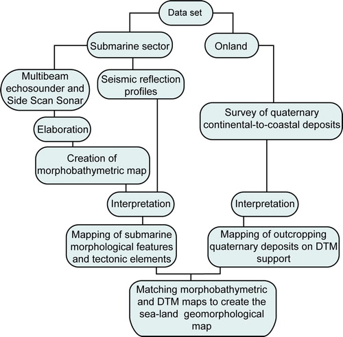
Our investigation is based on swath bathymetry data, backscatter images, high resolution seismic profiles ( and ). We analysed Multibeam echosounder and Side Scan Sonar data to detect erosive mass-wasting related slope failures as well as morpho-structural features. Sub-bottom stratigraphic information derived from acoustic surveys and sediment coring and grabbing techniques allow knowledge of seabed lithological and textural properties and reconstruction of the recent geological history of the study area.
Figure 3. Map of seismo-acoustic data set used for this study.
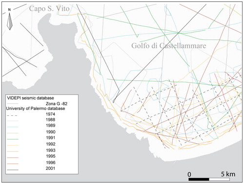
Figure 4. Flow diagram of the methodology followed for the construction of the final main map.
Most of the geophysical data were acquired in the context of oceanographic cruises carried out for the CARG (CARtografia Geologica; www.isprambiente.gov.it/it/progetti) and MAGIC (Marine Geohazards along the Italian Coasts; http://informare.magic project.it/) projects.
Multibeam data were acquired during two oceanographic surveys carried out in 2002 and 2004 on board of R/V ‘Tethis’ and ‘Universitatis’ respectively. The 2002 survey was performed by using a Reason SeaBat 8125 MBES, with a frequency of 455 kHz; the 2004 survey was performed by using a Reason SeaBat 8160 MBES, with a frequency of 50 kHz; the bathymetric data were processed by the PDS-2000 software. The Digital Terrain Model (DTM) was produced using 2–20 m cell size resolutions, according to the water depth, and merged in a final 20 m-resolution DTM.
High resolution acoustic (back-scatter) data were acquired during oceanographic cruises carried out during the years 1993–2000. Side Scan Sonar data were recorded using the Edge-tech DF 1000 with an operating frequency of 100 kHz and a 12-bit image resolution.
During the cruises the navigation was supported by a Differential Global Positioning System (DGPS) and a motion sensor to determine the attitude of the vessel in terms of pitch, roll and heave was applied; different CTD probes to calibrate the bathymetric dataset with the sound velocity variation within seawater were also performed during acquisition of Multibeam data.
High resolution seismic reflection profiles were acquired in the 1988, on board the R/V ‘Bannock’, and the 1989, on board the R/V ‘Minerva’, by a 1 kJ Sparker source and a single-channel streamer. Sub-bottom acoustic profiles were acquired during the 1988 on board the R/V Bannock through a hull-mounted 3.5 kHz operating frequency acoustic source. During both the 1988 and 1989 surveys the vessel positioning was supported by the LORAN-C navigation system.
The marine geological and geomorphological mapping of the San Vito Peninsula offshore, reproduced at 1:30.000 scale, is the result of a recent interpretation of the above mentioned seismo-acoustic data via visual inspection and analysis (). In detail, the marine geomorphological elements have been identified mainly through the 2D and 3D observation of the morpho-bathymetric map drawn from multibeam data. The recognised morphological features were also inferred and validated through the creation of transverse and longitudinal bathymetric profiles, the interpretation of seismic reflection profiles (where available), and also taking into account the characteristics of the sediments at the seafloor (e.g. composition, granulometry, sedimentary structures). Moreover, we integrated our results with previous researches, accomplished during the CARG and MAGIC projects. In the Main Map we used the legend developed in this context. The geological data represented along the on shore San Vito peninsula have been modified from the CitationAgate et al. (Citation2017) map and draped on a shaded relief map (http://map.sitr.regione.sicilia.it/ArcGIS/services/DTM_2m/MapSer ver/WMSServer). For the offshore area, the bathymetric basemap was generated starting from the marine DTM; isobaths are at 10-m interval from 0 to 50 m and at 50-m interval from 50 m downward to greater depth.
4. Results
Based on seafloor morphological attributes, three different sectors can be distinguished: eastern San Vito peninsula offshore; north-western San Vito peninsula offshore and the Scopello landslide, in the westernmost corner of the Castellammare Gulf continental shelf.
4.1. Eastern San Vito peninsula offshore
This area is characterised by a very narrow, in places absent, continental shelf above a very steep (up to 12-13° dip) upper slope. In this area, about 11 km long, the seabed is affected by several failure scars suggesting widespread mass wasting processes.
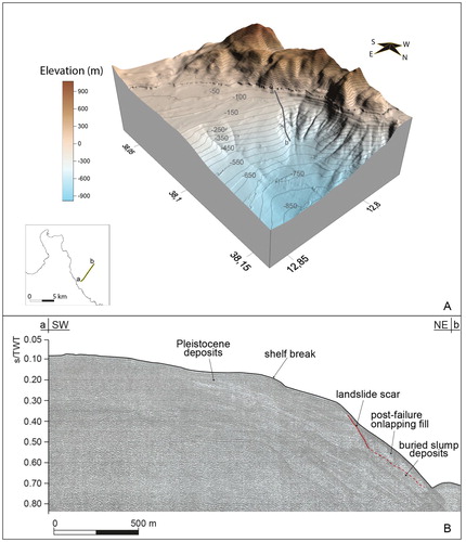
The southernmost slope failure in this sector is a NE-SW oriented, 3.700 m long erosive channel (A in ); it displays an amphitheatre like headscarp located 525 m off Cala dell’Uzzo, at 135 m water depth (). The channel shows an asymmetric, V-shaped cross section with the southern flank higher (up to 160 m) than the northern one (less than 100 m); the canyon walls are also affected by small landslide scars (see Main Map and ).
Figure 5. Shaded relief view of the San Vito peninsula offshore with the main geomorphological features described in the text.
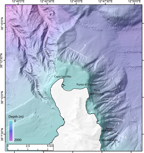
Figure 6. 3D view of the eastern sector of the San Vito peninsula offshore (A) and seismic reflection profile (1 kJ Sparker) showing landslide scar and related slump deposits (B) crossing the southern flank of the erosive channel off Cala dell’Uzzo (A in ).
Immediately north of this channel, another erosive channel, 1930 m long, with flanks up to 400 m high can be found down to the depth of 570 m (B in ); the channel has a funnel-shaped head, 370 m wide, located at a depth of 170 m and it is 370 m far from the coast.
Northward of this erosive furrow, a straight, E-W trending, up to 30 m high straight escarpment (C in ) offset the sea bed.
Off Cala dell’Impiso, another erosive channel (D in ), 3.200 m long scours the seabed down to depth of 750 m, where other two incisions converge: a narrow and straight furrow (E in ), up to 30 m deep; an erosive channel (F in ) which displays an arcuate pattern with a very asymmetric cross section and a well-developed northern flank up to 90 m high.
Off Punta di Solanto another relevant slope failure is represented by a funnel-shaped erosive channel (G in ), 2000 m long, up to 70 m deep, which displays a linear headscarp 1300 m wide, located at about 300 m water depth; the canyon shows a U-shaped cross section which downward narrows up to 400 m.
Off San Vito bay, where continental shelf is very narrow (less than 3500 m) the upper slope shows a gully morphology: seven shallow linear incisions (H in ), separated some hundreds of metres each from other, scour the seabed from the shelf break, located at 90–100 m, down the upper slope to 720 m water depth with straight course and parallel to each other.
Off eastern San Vito peninsula coast, some scattered slide scars have been also detected outside the submarine canyons. These slides are superficial and affect only the uppermost portion of the deposits beneath the seafloor. Scars mainly exhibit an ellipsoidal or amphitheatre-like morphology. The most evident slide scar has been detected 700 m eastward off Torre dell’Usciere (I in ); its transport area is detectable down to 635 m of depth, it is up to 640 m wide and it is bounded by up to 20 m high scarps.
Along the whole offshore area the seismo-acoustic SBP profiles show evidence of incipient destabilisation of the sedimentary cover as well. Scattered, very thin mass transport deposits have been mapped along the upper slope as well as in the proximal sectors of the Castellammare Basin: the largest one reaches an extension of about 5 km2 (see Main Map).
4.2. North-western San Vito peninsula offshore
Along the north-western offshore, the most prominent geomorphologic features are two adjacent submarine canyons: the Semaforo Canyon and the Cofano Canyon ().
Semaforo Canyon: it displays an amphitheatre shaped headscarp located 1 km far from Capo San Vito. The canyon is more than 10 km long and shows a slightly sinuous path and a slightly concave upward longitudinal profile with an average slope of 8.4°. It shows an enhanced asymmetric V-shaped cross section with the eastern flank up to 600 m high. This flank is scoured by erosive rills and it shows a 1500 m wide terrace at water depth between 1000 and 1100. The closest stretch to the coastline of this right flank shows a markedly rectilinear trend, oriented approximately north–south parallel to the faults recognised on land, suggesting the effect of a structural control on the position and path of this proximal stretch of the canyon.
Cofano Canyon: it is a prominent, erosive feature NNO-SSE trending scouring the upper slope that northwards deepens down to almost 2000 m ending in the intraslope Erice Basin. The width of the canyon, displaying a V-shaped cross-section, increases with depth until it exceeds 1 km. The canyon, more than 11 km long, shows a slightly sinuous path, a slightly upward convex longitudinal profile and very steep flanks scoured by a number of rills. A 3150 m wide slide scar is present along the eastern flank at depth between 330 and 650 m. The retrogressive evolution of this landslide could lead to the formation of a secondary tributary channel of the main one. Seismic reflection profiles document the canyon incised more than 300 m into bedded Pleistocene deposits.
The headscarp, showing an about 200 m wide, elongated, amphitheatre like shape, is located at a depth of about −130 m and determines a coastward retreat, of about 1700 m, of the shelf break. Landwards of the headscarp, a very narrow and shallow erosive channel develops which terminates at less than 500 m far from the coastline.
4.3. The Scopello landslide
The Scopello landslide is located in the south-eastern sector of the San Vito peninsula, close to the small village of Scopello (see Main Map and ), along the tectonic contact between the Meso-Cenozoic carbonate rocks (hanging wall) and the Tertiary silico-clastic deposits (foot wall) (see Structural Map in the Main Map).
The landslide has a length of over 3 km in an area of about 2.5 km2. Near the coast, the observed thickness of the landslide deposits reaches about 100 m, resulting in a convexity of the coastline (). Along the whole landslide body there are large carbonate blocks uprooted and rotated with a volume of several thousand cubic metres (CitationAgnesi et al., Citation1987). These blocks originate as a result of lateral spread and/or block slides, detaching themselves in correspondence with deep trenches parallel to the fault escarpment. Some of these blocks were transported to the sea where they originate stacks near the Tonnara di Scopello and Punta Pispisa. Below the sea level the extent of the landslide body was recognised up to 1400 m far from the coast ().
Figure 7. 3D view of the Scopello landslide and its extension in the coastal submerged area. a, b, c are topographic/bathymetric profiles along the landslide.

The movement of the landslide was complex: mainly earth/debris flow and, in the headscarp area, rotational sliding: the latter determined the dismemberment of the carbonate rocks above the clays in large prismatic blocks transported to the sea. In this way the surficial landslides interact with the deep-seated gravitational slope deformation which is at the origin of the landslide as a whole. The beginning of the landslide process cannot be determined precisely, even if pre-Holocene eluvial deposits were found under the transported carbonate blocks (CitationAgnesi et al., Citation1987). Following a period of intense movements recorded in the decade 1920–1930 in correspondence of abundant rains (CitationAgnesi et al., Citation1995) at present the entire landslide mass is affected by recurrent movements, more frequent at the front landslide.
5. Discussion
The different geomorphological character of the three sectors reveal the effect of the regional uplift and recent-to-active tectonics on the morphodynamic evolution.
The north-eastern sector is characterised by widespread seabed erosion mostly originated by extreme steepness of the upper slope, where submarine canyons and landslide scars are the most common failures. Canyons developed mostly as results of retrogressive mass failures that facilitate the upslope propagation of embryonic canyons towards the coast (CitationCatalano et al., Citation2011; CitationFarre et al., Citation1983; CitationPratson & Coakley, Citation1996); they are very short according to the reduced extension of the upper slope in this sector. In spite of the high slope of the seabed, which promote mass wasting, even the submarine landslides are small due to the reduced sedimentary supply. Submarine landslides could be triggered by recurrent seismicity occurring in this area. Gravitational phenomena can also be triggered by the rise of fluids, highlighted by morphological structures, such as pockmarks, which make a portion of the continental slope unstable and can evolve into channelised incisions (CitationDalla Valle & Gamberi, Citation2011; CitationPennino et al., Citation2014).
Canyons, furrows, and slide scars are important agents of submarine erosion and downslope sediment transfer from the upper slope to the deep flat areas. Along the eastern San Vito peninsula offshore, sea bed instability originates from widespread presence of these erosional features, and potential geohazard could originate from progressive approach of the headscarps to the coastline, where many touristic resorts and pocket beach crowded during the summer season occur.
The morphosedimentary dynamics on the north-western sector is dominated by Semaforo and Cofano canyons. V-shaped cross-section of both canyons suggests erosion due to gravity-driven flows along the thalweg (CitationBaztan et al., Citation2005); rills scoured into sidewalls indicate minor erosive sediment flows also occur. The latter caused undercutting that has reduced the stability of the sidewalls of the canyon, promoting sliding processes.
The Cofano canyon headscarp configuration suggests turbidity currents that originate the canyon occur at the end of the counter-clockwise littoral cell along the Cofano Bay. Morphological features on the whole suggest the canyon has been formed by erosive sediment flows with typical top-down evolution (CitationGreene et al., Citation2002). As concerns the genesis of the Semaforo Canyon, which seems to be isolated from the littoral sedimentary supply, retrogressive landslides along the upper slope had significantly contributed.
The retrogressive erosion of the Cofano canyon headscarp affects the continental shelf and interacts with the coastal morpho-sedimentary processes; further on this intense geomorphic activity represents a potential geohazard yielding sediment mass-wasting and failure, both on the shelf edge, where sediment loading is higher, and on the steep slope.
In the area of the Scopello landslide the presence of intensely faulted and fractured carbonates tectonically superposed on clays is a favouring factor of deep gravitational processes (CitationNemčok, Citation1977), allowing for gravitative movements of the carbonate lithoid unit over the clay-based substrate with plastic behaviour. An additional predisposing factor is the presence of joints and fractures originating from the late-Neogene compressional deformation (CitationCatalano et al., Citation2011), which also constitute preferential routes for the infiltration of rainwater. The trigger mechanisms can be seismic activity, ‘accelerated’ phases of relative sea level lowering due to tectonic uplift and/or eustatic falling, abundant rainfall with increase in groundwater circulation along the limestone-clay boundary. Further on, a relevant role in promoting these gravitational failures has been played by marine wave erosion with triggering of lateral spread movements (CitationAgnesi et al., Citation1987).
6. Conclusions
A sea-land geomorphological mapping of the San Vito peninsula and its offshore has been realised in order to assess geo-hazards for this coastal-marine area.
The morpho-bathymetric and seismostratigraphic investigation has evidenced the intense morpho-sedimentary dynamics in this sector of the northern Sicily margin, which has been subject to enhanced seafloor erosion by various gravity-driven processes.
Erosive features along the San Vito peninsula offshore are the result of extensive and recurrent slope failures during latest Pleistocene-Holocene time interval. Canyons at different stages of development, some of them showing important retrogressive activity, extensive along slope erosional features, faults escarpments and landslide scars are the most relevant detected features that could present a hazard for coastal areas.
In detail three different types of geo-hazards related to geomorphological features have been detected: extensive failure scars on upper slope, headwall scarps in canyon, a coastal landslide.
A major geo-hazard can be assessed in the area off east San Vito peninsula: here the seabed over-steepening caused by the tectonic uplift occurred during Pleistocene induces both the development of submarine canyons and a widespread slope instability. The southernmost sector of this area is threatened by persistent activity of the Scopello landslide. Therefore, this area on the whole is characterised by both potential submarine landslides and destabilisation of the coastal zone. In this situation gravitational processes can simultaneously affect the coast and the seabed, amplifying the marine-coastal geological risk.
Off northwest San Vito peninsula, active retrogressive evolution of Semaforo and Cofano canyons, suggesting a possible progressive approach to the present-day coastline, represents the most critical geo-hazard causing: (i) potential seabed instability and consequent mass-wasting processes affecting the steep flanks of both Semaforo and Cofano canyons; (ii) capture of coastal sediments, enhancing shoreline erosion.
In the last decades, some stretches of the coastline of the San Vito peninsula have been affected by withdrawal processes. Along Baia del Cofano small pocket beaches have disappeared following storms. Further on, the strong withdrawal that affected for several years the beach of San Vito Cape (particularly rapid between 1968 and 1992 years) seems to be mainly due to anthropogenic activities. Further observations and analyses will be necessary to establish whether the changes observed in coastal sedimentary dynamics are, also, ascribable to the offshore effects of gravitational instability connected to the submarine structures and morphologies described in this work.
Presence of a steep slope, neotectonic activity and seismicity are the factors promoting the sediment instability and following failure across the San Vito offshore area. A possible relationship between recent fault activity and the focussing of erosional and gravitational processes responsible for the furrows and canyons’ development can be only suggested, but only further investigations focused on neo-tectonic structures could verify the consistency of this hypothesis.
Overall, the offshore of the San Vito Peninsula is a marine-coastal area where we recognise: (i) outcropping geomorphological elements which represent geohazard for marine-coastal areas (e.g. Scopello landslide); (ii) submerged geomorphological features that constitute potential geohazard for coastal areas (e.g. retrograding canyon headscarps); (iii) continuous tectonic structures between land and sea (faults) that represent potential geological risks that threaten both the coastal and offshore areas. Results of this study indicate that the San Vito peninsula offshore may still prone to failure: further studies should better define which areas are most exposed to geo-hazard and provide estimates of the probability of new mass wasting events along the coast and the sea floor.
Software
The geomorphological main map and the Figures in the text were compiled using GLOBAL MAPPER, Surfer and Quantum-G GIS Software and redesigned to print with Adobe Illustrator.
Main_Map_Rev3.pdf
Download PDF (31.4 MB)Acknowledgements
We acknowledge the CARG Project (Geological Maps of Italy) funded by the ISPRA-Italian Geological Survey and the Italian National Research Projects MaGIC (Marine Geological Hazard along the Italian Coast) funded by the Italian Civil Protection Department. We thank also the captains and the crews of the R/V ‘Thetis’ and R/V ‘Universitatis’ for their assistance during the surveys. Many thanks to the Editor and the Reviewers for the useful suggestions that largely improved the manuscript.
Disclosure statement
No potential conflict of interest was reported by the author(s).
References
- Agate, M., Basilone, L., Di Maggio, C., Contino, A., Pierini, S., & Catalano, R. (2017). Quaternary marine and continental unconformity-bounded stratigraphic units of the NW Sicily coastal belt. Journal of Maps, 13(2), 425–437. https://doi.org/1080/17445647.2017.1314229
- Agate, M., Beranzoli, L., Braun, T., Catalano, R., Favali, P., Frugoni, F., Pepe, F., Smriglio, G., & Sulli, A. (2000). The 1998 offshore NW Sicily earthquakes in the tectonic frame work of the southern border of the Tyrrhenian Sea. Memorie della Società Geologica Italiana, 55, 103–114.
- Agate, M., Catalano, R., Infuso, S., Lucido, M., Mirabile, L., & Sulli, A. (1993). Structural evolution of the northern Sicily continental margin during the plio-pleistocene. In M. D. Max & P. Colantoni (Eds.), Geological development of the Sicilian-Tunisian platform (pp. 25–30). UNESCO Reports in marine science, 58.
- Agate, M., Cottone, S., Di Maio, D., Fallo, L., Mancuso, M., Scannavino, M., & Vaccaro, F. (2002). I fondali marini della Penisola di San Vito (Sicilia nord-occidentale). In Ruggieri, R., Attività esplorativa e ricerca nelle aree carsiche siciliane. Atti del 4° Convegno di Speleologia della Sicilia, Custonaci (TP) 1–5 maggio. Speleologia Iblea, 10, 83–95.
- Agate, M., Mancuso, M., & Lo Cicero, G. (2005). Late quaternary sedimentary evolution of the Gulf of Castellammare (NW Sicily offshore). Bollettino della Societa Geologica Italiana, 124, 21–40.
- Agnesi, V., Di Maggio, C., & Macaluso, T. (1995). Deformazioni gravitative profonde e superficiali nella penisola di Capo San Vito (Sicilia occidentale). Memorie della Società Geologica Italiana, 50, 11–21.
- Agnesi, V., Macaluso, T., & Pipitone, G. (1987). Ruolo delle deformazioni gravitative profonde nell’evoluzione geomorfologica dell’area di Scopello (Trapani). Bollettino della Societa Geologica Italiana, 106, 231–238.
- Antonioli, F., Puglisi, C., Reitano, G., & Tusa, S. (1998). Evoluzione geomorfologica pleistocenica del settore costiero di San Vito lo Capo (Sicilia): rapporti tra neotettonica, eustatismo e comunità preistoriche. Memorie descrittive della Carta Geologica d'Italia, 52, 337–360.
- Argnani, A., Tinti, S., Zaniboni, F., Pagnoni G., Armigliato A., Panetta D., & Tonini R. (2011). The eastern slope of the southern Adriatic basin: A case study of submarine landslide characterization and tsunamigenic potential assessment. Marine Geophysical Research, 32(1-2), 299–311. https://doi.org/10.1007/s11001-011-9131-3
- Baztan, J., Berné, S., Olivet, J.-L., Rabineau, M., Aslanian, D., Gaudin, M., Réhault J.-P., & Canals M. (2005). Axial incision: The key to understand submarine canyon evolution (in the western Gulf of Lion). Marine and Petroleum Geology, 22(6-7), 805–826. https://doi.org/1016/j.marpetgeo.2005.03.011
- Brink, U. S., Lee, H. J., Geist, L. E., & Twichell, D. (2009). Assessment of tsunami hazard to the U.S. East Coast using relationships between submarine landslides and earthquakes. Marine Geology, 264(1-2), 65–73. https://doi.org/1016/j.margeo.2008.05.011
- Canals, M., Lastras, G., Urgeles, R., Casamor, J. L., Mienert, J., Cattaneo, A., De Batist, M., Haflidason, H., Imbo, Y., Laberg, J.S., Locat, J., Long, D., Longva, O., Masson, D.G., Sultan, N., Trincardi, F., & Bryn, P. (2004). Slope failure dynamics and impacts from seafloor and shallow sub-seafloor geophysical data: Case studies from the COSTA project. Marine Geology, 213(1-4), 9–72. https://doi.org/1016/j.margeo.2004.10.001
- Casalbore, D., Chiocci, F. L., Scarascia Mugnozza, G., Tommasi P., & Sposato A. (2011). Flash-flood hyperpycnal flows generating shallow-water landslides at Fiumara mouths in Western Messina Strait (Italy). Marine Geophysical Research, 32(1-2), 257–271. https://doi.org/10.1007/s11001-011-9128-y
- Catalano, R., Agate, M., Basilone, L., Di Maggio, C., Mancuso, M., & Sulli, A. (2011). Foglio n° 593 Castellammare del Golfo. Note Illustrative della Carta Geologica d’Italia alla scala 1:50.000. ISPRA – SGI. Ente realizzatore: Regione Siciliana, Assessorato Territorio Ambiente. SystemCart, Roma, 2011, 239 pp.
- Catalano, R., Valenti, V., Albanese, C., Accaino, F., Sulli, A., Tinivella, U., Gasparo Morticelli, M., Zanolla, C., & Giustiniani, M. (2013). Sicily’s fold/thrust belt and slab rollback: The SI.RI.PRO. Seismic crustal transect. Journal of the Geological Society, 170(3), 451–464. https://doi.org/1144/jgs2012-099
- Chiocci, F. L., Cattaneo, A., & Urgeles, R. (2011). Seafloor mapping for geohazard assessment: State of the art. Marine Geophysical Research, 32(1-2), 1–11. https://doi.org/10.1007/s11001-011-9139-8
- Chiocci, F. L., Esu, F., Tommasi, P., & Chiappa, V. (1996). Stability of the submarine slope of the Tibet River delta. In K. Senneset (Ed.), Landslides: 7th International Symposium on Landslides (pp. 521–526). Balkema.
- Chiocci, F. L., & Ridente, D. (2011). Regional-scale seafloor mapping and geohazard assessment. The experience from the Italian project MaGIC (Marine Geohazards along the Italian Coasts). Marine Geophysical Research, 32(1-2), 13–23. https://doi.org/10.1007/s11001-011-9120-6
- Dalla Valle, G., & Gamberi, F. (2011). Pockmarks and seafloor instability in the Olbia continental slope (northeastern Sardinian margin, Tyrrhenian Sea). Marine Geophysical Research, 32(1-2), 193–205. https://doi.org/1007/s11001-011-9133-1
- Devoti, R., Riguzzi, F., Cuffaro, M., & Doglioni, C. (2008). New GPS constraints on the kinematics of the Apennines subduction. Earth and Planetary Science Letters, 273(1-2), 163–174. https://doi.org/1016/j.epsl.2008.06.031
- Di Maggio, C., Incandela, A., Masini, F., Petruso, D., Renda, P., Simonelli, C., & Boschian, G. (1999). Oscillazioni eustatiche, biocronologia dei depositi continentali quaternari e neotettonica nella Sicilia nord-occidentale (Penisola di San Vito Lo Capo, Trapani). Il Quaternario, 12(1), 25–50.
- Di Maggio, C., Madonia, G., & Vattano, M. (2014). Deep-seated gravitational slope deformatios in western Sicily: Controlling factors, triggering mechanisms, and morphoevolutionary models. Geomorphology, 208, 173–189. https://doi.org/1016/j.geomorph.2013.11.023
- Farre, J. A., McGregor, B. A., Ryan, W. B., & Robb, J. M. (1983). Breaching the shelfbreak: Passage from youthful to mature phase in submarine canyon evolution. In D. J. Stanley & G. T. Moore (Eds.), The shelf break: Critical interference on continental margins (Vol. 33, pp. 25–39). SEPM Special Publication.
- Ferranti, L., Antonioli, F., Mauz, B., Amorosi, A., Dai Pra, G., Mastronuzzi, G., Monaco, C., Orrù, P., Pappalardo, M., Radtke, U., Renda, P., Romano, P., Sansò, P., & Verrubbi, V. (2006). Markers of the last interglacial sea-level high stand along the coast of Italy: Tectonic implications. Quaternary International, 145-146, 30–54. https://doi.org/1016/j.quaint.2005.07.009
- Greene, H. G., Maher, N. M., & Paull, C. K. (2002). Physiography of the Monterey Bay National Marine Sanctuary and implications about continental margin development. Marine Geology, 181(1-3), 55–82. https://doi.org/1016/S0025-3227(01)00261-4
- Hough, G., Green, J., Fish, P., Mills, A., & Moore, R. (2011). A geomorphological mapping approach for the assessment of seabed geohazards and risk. Marine Geophysical Research, 32(1-2), 151–162. https://doi.org/10.1007/s11001-010-9111-z
- International Centre for Geohazard. (2003). Offshore Geohazards. https://www.ngi.no/eng/Projects/ICG-International-Centre-for-Geohazards/Offshore-Geohazards
- International Society for Soil Mechanics and Geotechnical Engineering. (2005). Geotechnical & geophysical investigations for offshore and nearshore developments. 101 pp.
- Kastens, K., Mascle, J., Auroux, C., Bonatti, E., Broglia, C., Channell, J., Curzi, P., Emeis, K.-C., Glaçon, G., Hasegawa, S., Hieke, W., Mascle, G., McCoy, F., McKenzie, J., Mendelson, J., Müller, C., Réhault, J.-P., Robertson, A., Sartori, R., Sprovieri, R., & Torii, M. (1988). ODP Leg 107 in the Tyrrhenian Sea: Insights into passive margin and back-arc basin evolution. Geological Society of America Bulletin, 100(7), 1140–1156.<1140:OLITTS>2.3.CO;2
- Larroque, C., de Lépinay, B. M., & Migeon, S. (2011). Morphotectonic and fault–earthquake relationships along the northern Ligurian margin (western Mediterranean) based on high resolution, multibeam bathymetry and multichannel seismic-reflection profiles. Marine Geophysical Research, 32(1-2), 163–179. https://doi.org/10.1007/s11001-010-9108-7
- León, R., & Somoza, L. (2011). GIS-based mapping for marine geohazards in seabed fluid leakage areas (Gulf of Cadiz, Spain). Marine Geophysical Research, 32(1-2), 207–223. https://doi.org/10.1007/s11001-011-9135-z
- L’Heureux, J.-S., Glimsdal, S., Longva, O., Hansen, L., & Harbitz, C. B. (2011). The 1888 shoreline landslide and tsunami in Trondheimsfjorden, central Norway. Marine Geophysical Research, 32(1-2), 313–329. https://doi.org/10.1007/s11001-010-9103-z
- Lo Iacono, C., Sulli, A., & Agate, M. (2014). Submarine canyons of north-western Sicily (Southern Tyrrhenian Sea): Variability in morphology, sedimentary processes and evolution on a tectonically active margin. Deep Sea Research Part II: Topical Studies in Oceanography, 104, 93–105. https://doi.org/1016/j.dsr2.2013.06.018
- Lo Iacono, C., Sulli, A., Agate, M., Lo Presti, V., Pepe, F., & Catalano, R. (2011). Submarine canyon morphologies in the Gulf of Palermo (Southern Tyrrhenian Sea) and possible implications for geo-hazard. Marine Geophysical Research, 32(1-2), 127–138. https://doi.org/10.1007/s11001-011-9118-0
- Mauz, B., Buccheri, G., Zoller, L., & Greco, A. (1997). Middle to upper Pleistocene morphostructural evolution of the NW-coast of Sicily: Thermoluminescence dating and palaeontological-stratigraphical evaluations of littoral deposits. Palaeogeography, Palaeoclimatology, Palaeoecology, 128(1-4), 269–285. https://doi.org/1016/S0031-0182(96)00033-8
- Morelli, D., Cuppari, A., Colizza, E., & Fanucci, F. (2011). Geomorphic setting and geohazard-related features along the Ionian Calabrian margin between Capo Spartivento and Capo Rizzuto (Italy). Marine Geophysical Research, 32(1-2), 139–149. https://doi.org/10.1007/s11001-011-9130-4
- Nemčok, A. (1977). Geological/tectonic structures. An essential condition for genesis and evolution of slope movement. IAEG Bull, 16, 127–130. https://doi.org/10.1007/BF02591468
- Nielsen, T., & Kuijpers, A. (2004). Geohazard studies offshore the Faroe Islands: Slope instability, bottom currents and sub-seabed sediment mobilisation. Geological Survey of Denmark and Greenland (GEUS) Bulletin, 4, 57–60. https://doi.org/34194/geusb.v4.4785
- Pennino, V., Sulli, A., Caracausi, A., Grassa, F., & Interbartolo, F. (2014). Fluid escape structures in the north Sicily continental margin. Marine and Petroleum Geology, 55, 202–213. https://doi.org/1016/j.marpetgeo.2014.02.007
- Pondrelli, S., & Salimbeni, S. (2006). Italian CMT Dataset [Data set]. Istituto Nazionale di Geofisica e Vulcanologia (INGV). https://doi.org/10.13127/rcmt/italy
- Pratson, L. F., & Coakley, B. J. (1996). A model for the headward erosion of submarine canyons induced by downslope-eroding sediment flows. Geological Society of America Bulletin, 108(2), 225–234. https://doi.org/1130/0016-7606(1996)108<0225:AMFTHE>2.3.CO;2
- Rabinovich, A. B., Geist, E. L., Fritz, H. M., & Borrero, J. C. (2015). Introduction to “Tsunami Science: Ten years After the 2004 Indian Ocean Tsunami. Volume I”. Pure and Applied Geophysics, 172(3-4), 615–619. https://doi.org/10.1007/s00024-015-1038-5
- Ruggieri, G., Buccheri, G., & Rendina, M. (1968). Segnalazione di Tirreniano fossilifero a Trapani. Rivista Mineraria Siciliana, 112-114, 1–4.
- Satake, K., Okal, E., & Borrero, J. C. (2007). Tsunami and its hazard in the Indian and Pacific Oceans: Introduction. Pure and Applied Geophysics, 2–12. https://doi.org/1007/978-3-7643-8364-0_1
- Satake, K., Rabinovich, A. B., Dominey-Howes, D., & Borrero, J. C. (2013). Introduction to “Historical and Recent Catastrophic Tsunamis in the World: Volume II. Tsunamis from 1755 to 2010”. Pure and Applied Geophysics, 170, 1361–1367. https://doi.org/10.1007/s00024-012-0616-z
- Strasser, M., Hilbe, M., & Anselmetti, F. S. (2011). Mapping basin-wide subaquatic slope failure susceptibility as a tool to assess regional seismic and tsunami hazards. Marine Geophysical Research, 32(1-2), 331–347. https://doi.org/10.1007/s11001-010-9100-2
- Urgeles, R., Cattaneo, A., Puig, P., Liquete, C., De Mol, B., Amblàs, D., Sultan, N., & Trincardi, F. (2011). A review of undulated sediment features on Mediterranean prodeltas: Distinguishing sediment transport structures from sediment deformation. Marine Geophysical Research, 32(1-2), 49–69. https://doi.org/1007/s11001-011-9125-1
- Yamada, Y., Kawamura, K., Ikehara, K., Ogawa, Y., Urgeles, R., Mosher, D., Chaytor, J., & Strasser, M. (Eds.). (2012). Submarine mass movements and their consequence. In Advances in natural and Technological hazard Research (Vol. 31). Springer Science+Business Media B.V. https://doi.org/1007/978-94-007-2162-3_1
- Yun, J. W., Orange, D. L., & Field, M. E. (1999). Subsurface gass offshore of northern California and its link to submarine geomorphology. Marine Geology, 154(1-4), 357–368. https://doi.org/1016/S0025-3227(98)00123-6
- Wezel, F. C., Savelli, D., Bellagamba, M., Tramontana, M., & Bartole, R. (1981). Plio-quaternary depositional style of sedimentary basins along insular Tyrrhenian margins. In F. C. Wezel (Ed.), Sedimentary basins of mediterranean margins (pp. 239–269). Tecnoprint.