
ABSTRACT
This work presents the geomorphological features associated with the anthropic morphogenesis of the Bisagno Stream catchment, combined with the geo-hydrological hazards associated with landslides and floods. This catchment is internationally known for its recurring high-magnitude floods and its geo-hydrological hazards associated with the large and widespread presence of elements exposed at risks. It experienced severe morphological changes due to anthropogenic interventions related to urban sprawl and agriculture. Anthropogenic modifications to the former landscape have been particularly widespread and pervasive over the coastline, the floodplain, and the slopes. They include a general alteration of the pristine landforms, excavation and landfill forms, channelization and culvert of riverbeds, and terraced slopes. The 1:20,000 scale map allows to assess the relationships existing among structures and infrastructures, anthropogenic landforms, and landslides and flood-prone areas. Thus, this tool provides relevant information for land-use planning and land management, in particular under the perspective of geo-hydrological hazards mitigation.
1. Introduction
Research on anthropogenic landforms has gained attention in the recent years. Some authors (Brown et al., Citation2017; Cooke et al., Citation1982; CitationCrutzen, 2002; Rosenbaum et al., Citation2003; Steffen et al., Citation2007; Tarolli et al., Citation2019) used the term Anthropocene to identify the period when human action is prevailing against natural processes, then highlighting the increasing capability of human beings as morphogenetic agents. This overtaking caused a strong acceleration in modelling anthropogenic landforms.
Many authors focused their research on urban geomorphology, which is a relatively recent branch of geomorphology that investigates the anthropogenic landscapes resulting from the modification of natural landforms (Brandolini et al., Citation2017; Citation2019; Cooke, Citation1976; Cooke et al., Citation1982; Huggenberger & Epting, Citation2011). This research field aims to identify the landscape anthropogenic elements and to analyze the current and past landscape evolution processes in order to assess the human impact on the morphoevolution. Numerous studies investigated geo-hydrological hazards (after Canuti et al., Citation2001) in anthropogenic environments focusing for example on slope-instability (Bozzano et al., Citation2006; Cevasco et al., Citation2010; Citation2015; Citation2017; Pepe et al., Citation2019a; Santo et al., Citation2017), river-related (Aronica et al., Citation2012; De Musso et al., Citation2018; Mandarino et al., Citation2019a; Citation2020a; Segura-Beltrán et al., Citation2016) and coastal processes (Ferrari et al., Citation2019; Stamatopoulos et al., Citation2014). Under this perspective, the anthropogenic landform mapping, along with the assessment of geo-hydrological hazards, allows a relevant tool for understanding the relationships between anthropogenic interventions and natural geomorphic processes (Paliaga et al., Citation2019a, 2020b; Piana et al., Citation2019). Due to the complexity and the subsequent stratification which is typical of urban areas with an old-time origin (Bathrellos, Citation2007; Luberti et al., Citation2018a, Citation2018b), the anthropogenic landform identification often requests a peculiar approach and the adaptation of methodologies typically adopted in the natural environment (Del Monte et al., Citation2016; Vergari et al., Citation2020).
In the Mediterranean area the ancient origin of many settlements, which through historical stages have developed to the actual cities, resulted in the overlapping of anthropogenic geomorphic processes as happens for the natural ones (Luberti et al., Citation2019): some landforms have been cancelled through times, and others have been progressively modified. Finally, the result is overall a complex of anthropogenic landforms that are often strictly woven each other and with the natural ones. Physiographical settings characterized by the presence of steep slopes, water courses and the seaside represent further obstacles to understand the landscape morphological evolution and to investigate and map landforms.
This morphological complexity widely affects the Bisagno Stream catchment, that is a Mediterranean catchment severely shaped by anthropogenic interventions, with a large presence of elements at risk, and highly prone to river-related and gravity-induced geomorphic processes. This area was already investigated in numerous studies focusing on the landscape evolution (Piana et al., Citation2019), on the geo-hydrological hazard (Cevasco et al., Citation2010; Faccini et al., Citation2016; Paliaga et al., Citation2019a; Citation2019b; Rosso & Rulli, Citation2002; Rulli & Rosso, Citation2002), on its relationships with the anthropogenic modification of the catchment (Faccini et al., Citation2015a; Citation2015b; Citation2018; Paliaga et al., Citation2019a; Citation2020a; Citation2020b) and on structural works for flood risk reduction (Ferrari et al., Citation2014; Lunardi et al., Citation2019; Redaelli & Bringiotti, Citation2019). This catchment experienced a severe urbanization close to the seaside that quickly vanishes moving towards the hinterland where steep slopes and narrow, poorly-urbanized valleys dominate the landscape.
The urban area close to the seaside is affected by an high geo-hydrological hazard associated with the frequent high-intensity rainfall events that hit this area (Brandolini et al., Citation2012; Paliaga et al., Citation2019c; Palla et al., Citation2018). The events seriousness has been increasing after the human modifications occurred in the small floodplain starting from the nineteenth century (Amponsah et al., Citation2016; Parodi et al., Citation2012). Here buildings and constructions saturated the available space; the main water course was channelized and culverted in its downstream reach, and the same alterations affected its tributaries. These landscape changes resulted in an increase of both flooding hazard and risk. Besides, climate change appears responsible of the increase of rain intensity in the last 20 years (Acquaotta et al., Citation2019).
The mountainous hinterland, which has been sparsely settled since the pre-industrial period, is subject to several and diffuse instability processes with landslides of various kind that affect buildings and infrastructures. This paper presents a novel catchment-scale map strictly focused on the anthropogenic landforms and the geo-hydrological hazards associated with flooding and slope-instability processes. This map aims, on the one hand, to increase the citizen’s awareness about both the anthropogenic landscape changes and the geo-hydrological hazards and, on the other hand, to provide useful information for land use planning, land management, and geo-hydrological risk assessment.
2. General settings
2.1. Geography
The Bisagno Stream catchment is a coastal basin located in the central part of Liguria region (North-Western Italy – ); it includes various municipalities belonging to Genova Metropolitan Area.
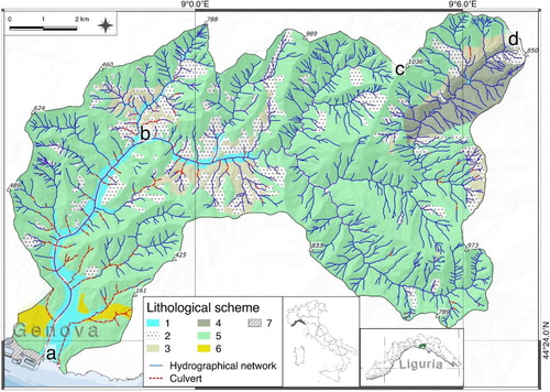
Figure 1. Lithological sketch map of Bisagno Stream Catchment. Legend: (1) alluvional deposit, (2) landslides, (3) shales (argilliti di Montoggio, autoct.), (4) siltstones and sandstones (formazione di Ronco, autoct.), (5) marly limestone (Flysch di Monte. Antola, autoct.) (6) stiff fissured clay (argille di Ortovero, auctoct.). (7) Waterfront embankment. The letters indicate relevant places: (a) Foce, (b) Molassana, (c) Mt. Candelozzo, (d) Scoffera Pass.
It spreads over 97.7 km2 and is diffusely characterized by steep slopes and narrow valleys (Brancucci & Paliaga, Citation2005; Faccini et al., Citation2018). The highest elevation of Mt. Candelozzo in the north-eastern part, reaches 1037 m a.s.l. at about ten kilometers distance from the coast.
The total length of the main stream, from the watershed to the mouth, is about 26 km; it is mostly confined, while the floodplain reaches a maximum extension of about 700 m in width in the lower part of the catchment.
Mean annual rainfall and air temperature are respectively 1290.3 mm and 12.6 °C recorded in the period 1961–2010 (CitationARPAL, 2013).
Atlantic atmospheric disturbances are often diverted to the Genova Gulf, typically in the autumn season. The consequence is the occurrence of intense precipitation between the third week of October until the end of November, due to the contrast between continental cold air from the north and the marine warmer and moister air from the south (Pasquale et al., Citation1994; Russo et al., Citation2000). High intensity precipitation and lightning activity are often associated to flooding (Paliaga et al., Citation2019c; Pignone et al., Citation2017; Silvestro et al., Citation2012; Citation2016a; Citation2016b; Citation2019).
The Bisagno Stream catchment is heavily urbanized in its middle and lower parts, particularly in the main valley bottoms. The upper part and, in general, the steepest slopes are prevalently covered by woods while cultivated areas are rare and somewhat scattered (Piana et al., Citation2019). The mountainous portions of the basin experienced a severe depopulation due to the significant social and economic changes which occurred after the Second World War (Agnoletti, Citation2007; MacDonald et al., Citation2000).
These dynamics resulted, over time, in farmland abandonment and, thus, drystone walls and drain channels maintenance interruption, with tragic consequences in terms of geo-hydrological hazards (Arnáez et al., Citation2011; Koulouri & Giourga, Citation2007; Pepe et al., Citation2019b; Piana et al., Citation2019).
2.2. Geology
Almost 90% of the catchment () is characterized by Cretaceous marly limestone (flysch di Monte Antola, autoct.), consisting of metric to plurimetric marly limestone turbidite layers with centimetric clayey shales interlayers (Capponi et al., Citation2009). In the central part of the catchment, near Molassana district, black/dark green marly shales (argilliti di Montoggio) with rare sandy layers, representing the marly limestone base complex, crop out (Cimmino et al., Citation2004 CitationElter et al., 2014). To the east, the main outcropping bedrocks are siltstones mixed with sandstones and slates (formazione di Ronco, autoct.). Finally, stiff fissured clays (argille di Ortovero, autoct.) outcrop in typical horst and graben structures near the coastline (Hoogerduijn Strating, Citation1994).
The tectonic setting has evolved in brittle and ductile deformation with NE-SW and NNW-SSE preferential directions that are responsible of the general asset of the catchment and of the hydrographical network (Brancucci & Paliaga, Citation2005; Capponi et al., Citation2009; Fanucci & Nosengo, Citation1977; Mandarino et al., Citation2015; Paliaga, Citation2015; Pellegrini et al., Citation2003).
2.3. Geomorphology
The Bisagno Stream catchment landforms are mainly shaped by gravity-induced and fluvial processes, along with anthropogenic interventions (Faccini et al., Citation2016). Chemical weathering plays a minor role in morphogenesis. Indeed, small cavities for calcium carbonate minerals dissolution occur, but are rare. V-shaped valleys drain the whole catchment and generally follow the aforementioned regional geological lineaments.
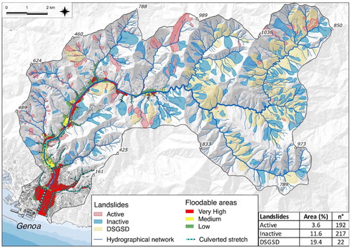
Various types of landslides, distinguished by size, velocity and activity state, have been recognized in the catchment (Città Metropolitana di Genova, Citation2015; Paliaga et al., Citation2019c). Extent active and inactive ones () are particularly present along geological contacts. Moreover, the occurrence of the Deep-Seated Gravitational Slope Deformation (DSGSD) in medium-high segment is due to the rheological contrast between marly limestone and its base complex (Paliaga et al., Citation2019a; CitationSacchini et al., 2016a).
Figure 2. Landslides inventory and floodable areas sketch map. Legend: very high corresponds to the 50 years return period, medium corresponds to the 200 years return period and low corresponds to a return period of 500 years (Modified from CitationPaliaga et al., 2019d and CitationPaliaga et al., 2020b. Data from CitationCittà Metropoitana di Genova, 2015).
Streams and creeks are generally confined and present a bedrock or semi-alluvial channel. The main valley abruptly spreads at Prato neighborhood, where the Bisagno riverbed widens and becomes alluvial (CitationBrancucci & Paliaga, 2005). The floodplain is definitely observable downstream of the confluence of the Geirato Creek (CitationPaliaga et al., 2020b). The coastline close to the Bisagno Stream mouth is completely modified by anthropogenic interventions (CitationFaccini et al., 2015b; Citation2016; Citation2020). Both urbanization in lowland areas and along the slopes and agricultural terraces, severely modified the original landforms and resulted in a widespread anthropogenic landscape whose main features are discussed later (CitationAgnoletti, 2007; CitationArnáez et al., 2011; CitationKoulouri & Giourga, 2007; CitationMacDonald et al., 2000; CitationPepe et al., 2019b; CitationPiana et al., 2019)
3. Materials and methods
The Bisagno Stream catchment anthropogenic landforms and geo-hydrological hazard map, represented at 1:20,000 scale, was realized through a synergic use of bibliographic research, previous researches summarization, and photograph interpretation in a GIS environment. Numerous researches focusing on the geomorphological features, the landscape evolution and the geo-hydrological hazards (references in the Introduction) of the study area were reviewed, re-elaborated and summarized, and thus provided a wide set of data and information concerning: (i) the spatial distribution and temporal evolution of anthropogenic landforms within the Bisagno Stream catchment, (ii) the urban and agricultural landscape evolution, and (iii) the floods and sea storm surges that affected the study area. Moreover, further information was collected from the Genova Municipality Master Plan, the Bisagno catchment management plan, technical reports, official databases concerning geo-environmental data, and historical documents.
On these bases, the anthropogenic geomorphological elements were partly imported from available databases and partly manually-digitized in a GIS environment considering the available information and using the 2018 Google Earth image and the 2016 Liguria Region orthophotograph at 1:5,000 scale as a base ().
Table 1. The mapped anthropogenic landforms and relative sources. The term ‘Original’ indicates the elements that were mapped on the basis of bibliographic information and photointerpretation.
The landforms and deposits in the main map are classified by using an original legend considered suitable to describe in detail the local setting. This legend is based on the Italian Institute for Environmental Protection and Research guidelines (CitationCampobasso et al., 2018) and the artificial ground classification adopted by the British Geological Survey (CitationRosenbaum et al., 2003), and presents some integrations.. In particular, we considered the following categories: worked ground (i.e. erosional landforms, after CitationCampobasso et al., 2018), made ground (i.e. constructional landforms, after CitationCampobasso et al., 2018), worked underground, and landscaped ground. This last corresponds to the extensively remodelled areas, where it was substantially impossible to separately identify erosional and depositional landforms. Furthermore, the anthropogenic landforms associated with the hydrographic network were grouped in the specific river-related landforms category.
The floodable area referred to the 50-year flood and landslides were considered in order to investigate the anthropogenic landforms distribution with respect to geo-hydrological hazards. The former was derived from the Liguria Region Geoportal and the latter from the Bisagno catchment management plan data (Paliaga et al., Citation2019b, Citation2020a), integrated with the 2014 extreme meteo-hydrological event ground effects. Landslides were overall distinguished between ‘Active’ and ‘Inactive’ (CitationCittà Metropolitana di Genova, 2015), whereas deep seated gravitational slope deformations were mapped separately. Furthermore, the sites where sink-holes were shaped, were manually digitized.
The general cartographic elements (i.e. contours, mounts and buildings) along with the cultural heritage data were imported from the Liguria Region Geoportal. The inset maps accompanying the main map were derived from the 5m-cell-size DEM of Regione Liguria, aiming to illustrate the physiographical features of the investigated catchment. Stratigraphical information (e.g. thickness, age, etc.) reported in the paper was derived from the available boreholes database (Regione Liguria, 2020) carried in the study area with different purposes.
4. Anthropogenic landforms and geo-hydrological hazards
4.1. Anthropogenic landforms
The Bisagno Stream catchment anthropogenic landforms were grouped into five categories: Landscaped ground, Made ground, Worked ground, Worked underground, and River-related landforms. Furthermore, some relevant cultural heritage elements were also mapped.
4.1.1. Landscaped ground
The first set includes main and secondary generally paved roads (the dirt roads are extremely rare). Railways belongs both to the national railroad system, here represented by the Brignole Railway Station, and the minor Genova-Casella railway line which is located on slopes in the western-most part of the catchment.
The urbanized landscape ( and (A)) due to two centuries old modifications ( and ) reaches the 15% of the total cover, with a remarkable density both in the plain and on the slopes. The spreading of buildings areas has increased to the detriment of agricultural landscape with terraced slope after the industrialization in the half of twentieth century (CitationChengtai, 1996; CitationPaliaga et al., 2020a; CitationPiana et al., 2019).
Figure 3. Urban area evolution sketch map in the last two centuries (from 19th to 21th century). In red squares the reference of (B) and (A).
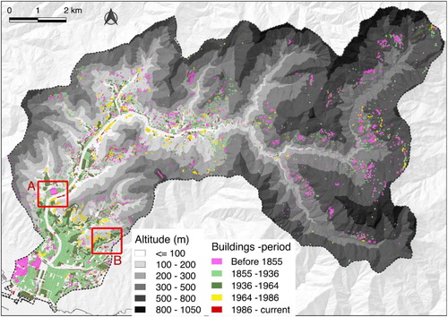
Figure 4. Anthropogenic landforms (after CitationRosenbaum et al., 2003) along Bisagno stream catchment. In (A) the urban area of Bisagno Catchment with its high building density. In foreground Staglieno (1) and Marassi neighborhood (2). On background the Foce (the mouth) and the Ligurian Sea (3). In (B) the present excavation for reconstruction work of the Bisagno culvert. In (C) the Molassana quarry, the lithotype is marly limestones. In (D) an air-raid shelter of II World War in Bisagno Stream catchment.
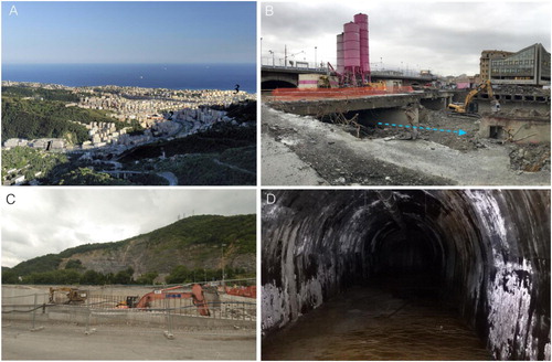
Figure 5. The evolution of urban cover in the residential neighborhoods of San Martino and San Fruttuoso using topographic maps at original scale 1:25’000 in (A) 1878; (B) 1907; (C) 1936 (from Italian Military Geographic Institute); (D) 1995 (Regional Technical Map, Regione Liguria)
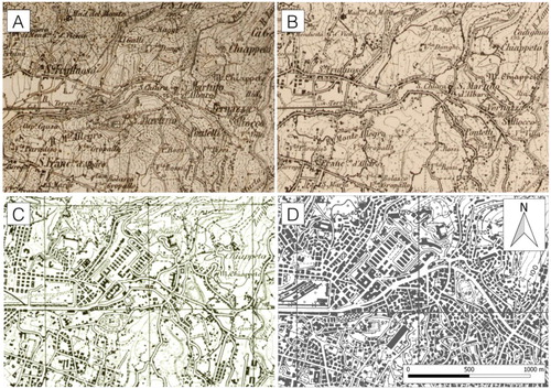
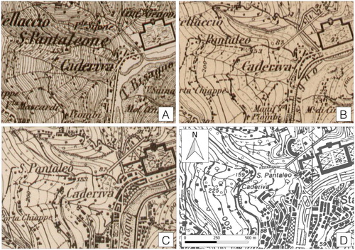
Figure 6. The urban area evolution around the Staglieno Monumental Cemetery from the 1:25,000 scale topographic map of the Italian Military Geographic Institute dated back to 1878 (A), 1907 (B), 1934 (C), and from the Regional Technical Map of the Regione Liguria dated back to 1995 (D). In (D), on the southern side of the cemetery, it is possible to observe the upstreammost culverted reach of the Bisagno stream, that was realized in the second half of twentieth century.
4.1.2. Made ground
As previously mentioned, Brignole is an important junction for the national railroad system. Its railway embankment sites over the floodplain, cutting in E-W direction the Bisagno Stream for a length of about 700 m. Other remarkable filling areas are the ‘Genova Est’ highway exit along the Veilino Creek, the Monumental Cemetery of Staglieno in the namesake neighborhood and San Martino University Campus and other industrial complexes on the hydrographic left of the valley.
Industrial complexes are mainly localized in Sant’Eusebio and Molassana districts where a small inert dump has been realized in the 1980s.
In order to contrast the marine surge and protect the 1950s waterfront filling, a series of shoreline protections were realized. Moreover, a beach made by anthropogenic gravel deposits currently reworked by the sea is situated close to the Bisagno Stream mouth.
4.1.3. Worked ground
This category includes open-pit quarries and partly-open-pit and partly-underground quarries mainly located along the main valley ((C)). The quarrying activity began in the Middle Age, but its maximum intensity was between the 1950s and 1970s during the so-called Italy economic miracle, which was an epoch of intense supplying demand for building and filling stone materials. Furthermore, excavation surfaces corresponding to areas where the ground is known to have been artificially cut away, generally for urban sprawl purposes, were mapped.
4.1.4. Worked underground
Several tunnels, both urban and railway and highway ones, have been realized in the last two centuries due to the hilly morphology of the catchment. Furthermore, other worked underground have been mapped: the underground quarries, the Second World War air-raid shelters realized as a defense against Allies bombardment ((D)), and two currently under construction spillways. These last elements were projected to drastically reduce the 50-years return period floodable area of the Bisagno Stream and Ferregiano Creek, and thus the geo-hydrological risk that affects the City of Genova.
4.1.5. River-related landforms
Severe riverbed alterations with respect to both the minor hydrographic network and the main channels have been documented. Channelization associated with the drystone-walls construction on slopes affected many low-order channels. Considering the difficulty of distinguishing these features from low-order channels without works and their impact, both of them were mapped as poorly modified riverbeds. The progressive urbanization of lowland areas and adjacent slopes resulted in the riverbeds narrowing and channelization with consequent occupation of riverine areas, as largely documented in other cases (CitationCencetti et al., 2017; Mandarino et al., Citation2019b; Citation2020b; Roccati et al., Citation2020; CitationSurian et al., 2009).
Furthermore, in the lower part of the catchment, most of the Bisagno tributaries are partly or completely culverted, along with the Bisagno riverbed itself between Brignole and Foce ((B)). This reach is 1.4 km long and was rectified and culverted in 1930s to obtain space for buildings. Check-dams and bed sills are sporadically scattered, except in Prato Casarile locality as described later.
4.2. Geo-Hydrological hazard
Bisagno Stream Catchment is historically known for its high geo-hydrological hazards. The earth surface processes and landforms are strictly related to the meteo-hydrological events and the geologic/geomorphologic characteristics of the territory (Canuti et al., Citation2001). The most frequent and widespread are flash floods and landslides (). Flash flood events have been described since VI century CE.
The 25-26th October 1822 event was directly observed by Lord Byron and Mary Shelley: ‘a cloud, surcharged with electricity and water, burst above our heads in one torrent of what was rather a cataract than rain.’ (The flood) ‘sufficed […] to lay flat the walls which in that hilly country support the soil’ (Mary Shelley, Citation1844).
In the last 50 years, four events have been recorded: the 7-8th October 1970, 27th September 1992, 11th November 2011 (Silvestro et al., Citation2012) and 9th October 2014 ones (Luino et al., Citation2019; Paliaga et al., Citation2020a). The reason lies in the inadequate discharge capacity of the culvert that allowed to flow only 500 m3/s basing on 1908 data (Inglese et al., Citation1909) while the actual rebuilding will ensure at least a value of about 850 m3/s ((B)).
The 50-years floodable area covers almost the total extent of the fluvial plain exposing a large district of Genova to flooding risk (). The mitigation strategy applied by the Italian Government consisted in realizing the Fereggiano creek spillway, which has been completed in 2019, and the Bisagno stream one that should be accomplished in 2023. These structural works will ensure the drastic reduction of the 50-years floodable area.
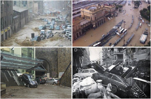
Figure 7. Extreme hydrological events. (A) The November 2011 Fereggiano creek flood; (B) The November 2011 Bisagno Stream flood at the Brignole Railway Station; (C) The October 2014 flood, near Brignole Railway Station; (D) The October 1970 flood at Foce neighborhood.
Landslides ( (Cruden & Varnes, Citation1996) are widespread in the Catchment and they can be divided in three different categories: active landslides, inactive and DSGSD (Creuden & Varnes, Citation1996); after Hungr et al., Citation2014). In the whole catchment a total of 192 active landslides, 217 inactive ones and 22 large DSGSD, covering respectively the 3.6%, the 11.6% and the 19.4% of the surface area have been detected (Paliaga et al., Citation2019c; Citation2020a). Recent shallow landslides with surface ranging 30,000-40,000 m2 are generally triggered by heavy and short rainfall events, especially between October and December.
Conversely, larger extent landslides, ranging 800,000-1,000,000 m2, (UNESCO, Citation1993) are characterized by a very slow velocity or, in some cases, are dormant. Sometimes, it was observed that small portions of paleo-landslides shall be reactivated (Sacchini et al., Citation2016a; Citation2016b; Citation2018).
The higher hazard () in the medium part of the catchment is represented by the Prato Casarile landslide dam placed in Geirato creek valley (Paliaga et al., Citation2019a). Here a paleo-landslide created a 1.75 million m3 dam and a paleo-lake that nowadays is completely sediment filled. During the 1970 heavy rain and flood event, a 100,000 m3 southern portion of the landslide dam collapsed, moving to the confluence with the Bisagno stream and contributing to the consequent flood damage.
Figure 8. Geo-hydrological hazards of Prato Casarile landslide dam. Legend: (A) 3D model and the perspective aerial view: (1) ephemeral lake; (2) alluvial fan; (3) sheet erosion; (4) active landslides; (5) landslide dam; (6) active regressive erosion after the 2014 heavy rains; (7) weirs; (8) artificial stream course. (B) landslide activated during the 2014 flood event and impacting part of the structures realized in 1989 to prevent the landslide dam collapse; (C) particular of the degraded structures along the Geirato creek, downstream the Prato Casarile landslide dam.
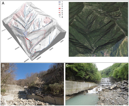
The hazard represented by the possible collapse of large portions of the landslide dam and of the filled lake threshold were avoided with heavy stabilization works (). After about 30 years from those interventions, the concrete structures are now in hardly degraded conditions (Paliaga et al., Citation2019a) and the hazard related to the possible collapse is increasing again. During the 2014 flood event a partial reactivation of the landslide dam occurred, causing damage along the Geirato creek with a ford, weirs and embankments collapse.
In the central and low catchment area (), it is possible recognizing different sized landslides affecting strategic structures, such as the filling area of the highway near Staglieno locality and the dump in Sant’Eusebio and Molassana neighborhoods.
The Deep-Seated Gravitational Slope Deformations (DSGSD) are particularly widespread along the geological contact between marly limestone, more brittle, and slate, more ductile.
Finally, a mention to the urban sink-hole phenomena which are less widespread but highly dangerous. The triggering occurs during intense rain events: covered channels may collapse because of the high pressure of flowing water, causing damage in the densely urban area.
4.3. Other elements
Other important elements are the cultural heritage such as the Cultural protected area (the 1700s and 1800s fortresses) and the Historical aqueduct (11th-19th centuries) which comprises few traces of the roman one. Recently about 28 km of the latest one has been converted in a walkway trail.
5. Final remarks
Field survey, aerial photographs and maps interpretation and comparison, and archival data investigations allowed to characterize and map the anthropogenic landforms and geo-hydrological hazards of the Bisagno Stream catchment (Liguria, Italy). The research permitted to sum up some years of geomorphological investigations carried out in an area exposed to a high geo-hydrological hazard associated with both floods and landslides (Scolobig et al., Citation2014; Sorg et al., Citation2018). Furthermore, the catchment was affected by a long-time evolution of human settlements that severely shaped the landscape and that is strictly related to the current geo-hydrological risk conditions.
The Bisagno Stream catchment is one of the twos belonging to Genova city, which is internationally known for its high geo-hydrological hazard. Its geomorphological features are shared all along the Liguria coastline and similar ones characterize several areas in the Mediterranean region, such as other Italian areas, the Cote d’Azur, the Greece, and the Spanish Mediterranean coastline. They are substantially: small or medium size catchments (less than 150 km2), mountainous area close to the coastline, a widespread urbanization often concentrated in the lower part of the catchment, resulting in a typical ‘bottleneck’, seasonal intense rainfall events occurrence, and low time of concentration. Thus, the Bisagno Stream catchment is prone to flash floods, particularly in its lower part, and to shallow landslides in the hinterland. In terms of climate change this situation appears critical, as a reduction in the number of rainy days has already been documented against an increase of rainfall intensity (Acquaotta et al., Citation2019). Then, in a framework of general decrease in mean precipitation in the Mediterranean area (Gaume et al., Citation2009; Hally et al., Citation2015), models suggest a possible intensification and shortening of rainfall events for the future in the western and northern part (Hertig & Jacobeit, Citation2008). This possible change represents a crucial issue in highly urbanized areas, particularly in coastal catchments as the Bisagno River is (Paliaga et al., Citation2020b).
Thus, a detailed map of the anthropogenic landforms related to geo-hydrological hazards may be adopted as a useful tool in planning measures for managing the effects of intense rainfall events, as the man-made landforms are known to have often been interference elements with respect to the natural processes evolution.
6. Software
The all data processing and the entire map sheet design was performed by using the free and open source software QGIS.
mappa_bisagno_200914_DEFINITIVO.pdf
Download PDF (32.8 MB)Acknowledgements
The authors sincerely thank the reviewers Leonidas Stamatopoulos, Francesca Vergari, and Heike Apps, and the editors Chiara Cappadonia and Alessandro Chelli, for their detailed and useful comments that helped to improve this manuscript and the related map.
Disclosure statement
No potential conflict of interest was reported by the authors.
Additional information
Funding
References
- Acquaotta, F., Faccini, F., Fratianni, S., Paliaga, G., Sacchini, A., & Vilìmek, V. (2019). Increased flash flooding in Genoa Metropolitan area: A combination of climate changes and soil consumption? Meteorology and Atmospheric Physics, 131(4), 1099–1110. https://doi.org/10.1007/s00703-018-0623-4
- ARPAL - Agenzia Regionale per la Protezione dell'Ambiente Ligure. (2013). Atlante climatico della Liguria. Available at http://www.arpal.gov.it/homepage/meteo/analisi-climatologiche/atlante-climatico-della-liguria.html Accessed 19 July 2016
- Agnoletti, M. (2007). The degradation of traditional landscape in a mountain area of Tuscany during the 19th and 20th centuries: Implications for biodiversity and sustainable management. Forest Ecology and Management, 249, 5–17. https://doi.org/10.1016/j.foreco.2007.05.032
- Amponsah, W., Marchi, L., Zoccatelli, D., Boni, G., Cavalli, M., Comiti, F., Crema, S., Lucía, A., Marra, F., & Borga, M. (2016). Hydrometeorological characterization of a flash flood associated with major geomorphic effects: Assessment of peak discharge uncertainties and analysis of the runoff response. Journal of Hydrometeorology, 17(12), 3063–3077. https://doi.org/10.1175/JHM-D-16-0081.1
- Arnáez, J., Lasanta, T., Errea, M. P., & Ortigosa, L. (2011). Land abandonment, landscape evolution, and soil erosion in a Spanish Mediterranean mountain region: The case of Camero Viejo. Land Degradation and Development, 22, 537–550. https://doi.org/10.1002/ldr.1032
- Aronica, G. T., Brigandí, G., & Morey, N. (2012). Flash floods and debris flow in the city area of Messina, north-east part of Sicily, Italy in October 2009: The case of the Giampilieri catchment. Natural Hazards and Earth System Sciences, 12(5), 1295. https://doi.org/10.5194/nhess-12-1295-2012
- Bathrellos, G. D. (2007). An overview in urban geology and urban geomorphology. Proceedings of the 11th international Congress, Athens, Bulletin of the Geological Society of Greece, XXXX, 1354-1364.
- Bozzano, F., Martino, S., & Priori, M. (2006). Natural and man-induced stress evolution of slopes: The Monte Mario hill in Rome. Environmental Geolology, 50, 505–524. https://doi.org/10.1007/s00254-006-0228-y
- Brancucci, G., & Paliaga, G. (2005). Geomorphic characterization of the main drainage basins of maritime Liguria (Italy) - preliminary results. Geografia Fisica e Dinamica Quaternaria, VII, 59–67.
- Brandolini, P., Cappadonia, C., Luberti, G. M., Donadio, C., Stamatopoulos, L., Di Maggio, C., Faccini, F., Stanislao, C., Vergari, F., Paliaga, G., Agnesi, V., Alevizos, G., & Del Monte, M. (2019). - Geomorphology of the Anthropocene in Mediterranean urban areas. Progress in Physical Geography 44(4), 461–494. https://doi.org/10.1177/0309133319881108
- Brandolini, P., Cevasco, A., Firpo, M., Robbiano, A., & Sacchini, A. (2012). Geo-hydrological risk management for civil protection purposes in the urban area of Genoa (Liguria, NW Italy). Natural Hazards and Earth System Sciences, 12, 943–959. https://doi.org/10.5194/nhess-12-943-2012
- Brandolini, P., Faccini, F., Paliaga, G., & Piana, P. (2017). Urban geomorphology in coastal environment: Man-made morphological changes in a seaside tourist resort (Rapallo, Eastern Liguria, Italy). Quaestiones Geographicae, 36(3), 97–110. https://doi.org/10.1515/quageo-2017-0027
- Brown, A. G., Tooth, S., Bullard, J. E., Thomas, D. S. G., Chiverrell, R. C., Plater, A. J., Murton, J., Thorndycraft, V. R., Tarolli, P., Rose, J., Wainwright, J., Downs, P., & Aalto, R. (2017). The geomorphology of the Anthropocene: Emergence, status and implications. Earth Surface Processes and Landforms, 42(1), 71–90. https://doi.org/10.1002/esp.3943
- Campobasso, C., Carton, A., Chelli, A., D’Orefice, M., Dramis, F., Graciotti, R., Guida, D., Pambianchi, G., Peduto, F., & Pellegrini, L. (2018). Aggiornamento ed integrazioni delle linee guida della Carta geomorfologica d’Italia alla scala 1:50.000. Servizio Geologico d’Italia - ISPRA [in Italian].
- Canuti, P., Casagli, N., Pellegrini, M., & Tosatti, G. (2001). Chapter 28 ‘Geo-hydrological hazards’. In G. B. Vai, & I. P. Martini (Eds.), Anatomy of an Orogen, the Apennines and adjacent Mediterranean basins (pp. 513–532). Kluwer Academic Publisher.
- Capponi, G., Crispini, L., Federico, L., Piazza, M., & Fabbri, B. (2009). Late Alpine tectonics in the Ligurian Alps: Constraints from the Tertiary Piedmont basin conglomerates. Geological Journal, 44, 211–224. https://doi.org/10.1002/gj.1140
- Cencetti, C., De Rosa, P., & Fredduzzi, A. (2017). Geoinformatics in morphological study of river Paglia, Tiber river basin. Central Italy. Environmental Earth Sciences, 76, 128. https://doi.org/10.1007/s12665-017-6448-5
- Cevasco, A., Pepe, G., D’Amato Avanzi, G., & Giannecchini, R. (2015). A study on the 10 November 2014 intense rainfall and the related landslides in the lower Lavagna valley (eastern Liguria). Rendiconti Online Società Geologica Italiana, 35, 66–69. https://doi.org/10.3301/ROL.2015.65
- Cevasco, A., Pepe, G., D’Amato Avanzi, G., & Giannecchini, R. (2017). Preliminary analysis of the November 10, 2014 rainstorm and related landslides in the lower Lavagna Valley (Eastern Liguria). Italian Journal of Engineering Geology and Environment, 1, 5–15. https://doi.org/10.4408/IJEGE.2017-01.S-01
- Cevasco, A., Sacchini, A., Robbiano, A., & Vincenzi, E. (2010). Evaluation of rainfall thresholds for triggering shallow landslides on the Genoa Municipality area (Italy): the case study of the Bisagno Valley. Italian Journal of Engineering Geology and Environment, 1, 35–50. https://doi.org/10.4408/IJEGE.2010-01.O-03
- Chengtai, D. (1996). An approach to theory and methods of urban geomorphology. Chinese Geographical Science, 6(1), 88–95.
- Cimmino, F., Faccini, F., & Robbiano, A. (2004). Stones and coloured marbles of Liguria in historical monuments. Periodico di Mineralogia, 73 (Special Issue 3: a showcase of the Italian research in applied petrology), 71–84.
- Città Metropolitana di Genova. (2015). Basin Master Plan of the Bisagno Stream Catchment, Technical Report (in Italian). Available at http://www.pianidibacino.ambienteinliguria.it/GE/genova.html
- Cooke, R. U. (1976). Urban geomorphology. Geographical Journal, 142(1), 59–65. https://doi.org/10.2307/1796025
- Cooke, R. U., Brunsden, D., & Doornkamp, J. C. (1982). Urban geomorphology in Drylands. Oxford University Press.
- Cruden, D. M., & Varnes, D. J. (1996). Landslide types and processes. In A. K. Turner & R. L. Schuster (Eds.), Landslides investigation and mitigation. Transportation research board, US National Research Council, Special Report 247, (Chapter 3, pp. 36–75). Transportation Research Board.
- Crutzen, P. J. (2002). Geology of mankind. Nature, 415, 23. https://doi.org/10.1038/415023a
- Del Monte, M., D’Orefice, M., Luberti, G. M., Marini, R., Pica, A., & Vergari, F. (2016). Geomorphological classification of urban landscapes: The case study of Rome (Italy). Journal of Maps, 12(1), 17. https://doi.org/10.1515/quageo-2017-0022
- De Musso, N. M., Capolongo, D., Refice, A., Lovergine, F. P., D’Addabbo, A., & Pennetta, L. (2018). Spatial evolution of the December 2013 Metaponto plain (Basilicata, Italy) flood event using multi-source and high-resolution remotely sensed data. Journal of Maps, 14, 219–229. https://doi.org/10.1080/17445647.2018.1454349.
- Elter, P., Marroni, M., & Pandolfi, L. (2014). Sheet 214 “Bargagli”, Italian Geological Map at scale 1:50'000, Project CARG, ISPRA.
- Faccini, F., Giardino, M., Paliaga, G., Perotti, L., & Brandolini, P. (2020). Urban geomorphology of Genoa Old City (Italy). Journal of Maps, https://doi.org/10.1080/17445647.2020.1777214
- Faccini, F., Luino, F., Paliaga, G., Sacchini, A., & Turconi, L. (2015a). Yet another disaster flood of the Bisagno stream in Genoa (Liguria, Italy): October the 9th-10th 2014 event. Rendiconti Online Società Geologica Italiana, 35, 128–131. https://doi.org/10.3301/ROL.2015.81
- Faccini, F., Luino, F., Paliaga, G., Sacchini, A., Turconi, L., & de Jong, C. (2018). Role of rainfall intensity and urban sprawl in the 2014 flash flood in Genoa City, Bisagno catchment (Liguria, Italy). Applied Geography, 98, 224–241. https://doi.org/10.1016/j.apgeog.2018.07.022
- Faccini, F., Luino, F., Sacchini, A., & Turconi, L. (2015b). Flash flood events and urban development in Genoa(Italy): lost in translation. In G. Lollino, A. Manconi, F. Guzzetti, M. Culshaw, P. Bobrowsky, & F. Luino (Eds.), Engineering Geology for Society and Territory. Springer International Publishing, 5, 797–801. https://doi.org/10.1080/17445647.2018.1535454
- Faccini, F., Paliaga, G., Piana, P., Sacchini, A., & Watkins, C. (2016). The Bisagno stream catchment (Genoa, Italy) and its major floods (1822, 1970 and 2014): geomorphic and land use variations in the last three centuries. Geomorphology, 273, 14–27. https://doi.org/10.1016/j.geomorph.2016.07.037
- Fanucci, F., & Nosengo, S. (1977). Rapporti tra neotettonica e fenomeni morfogenetici del versante marittimo dell’Appennino ligure e del margine continentale. Bollettino Società Geologica Italiana, 96, 41–51.
- Ferrari, M., Belicchi, M., Cerlini, D., & Majone, U. (2014). The Bisagno River Diversion. Proceedings of the International Conference on Fluvial Hydraulics, RIVER FLOW 2014, Lausanne, Switzerland, 1757-1765. https://doi.org/10.3390/su11174594
- Ferrari, M., Carpi, L., Pepe, G., Mucerino, L., Schiaffino, C. F., Brignone, M., & Cevasco, A. (2019). A geomorphological and hydrodynamic approach for beach safety and sea bathing risk estimation. Science of The Total Environment, 671, 1214–1226. https://doi.org/10.1016/j.scitotenv.2019.03.378
- Gaume, E., Bain, V., Bernardara, P., Newinger, O., Barbuc, M., Bateman, A., & Viglione, A. (2009). A compilation of data on European flash floods. J. Hydrol, 367, 70–78. https://doi.org/10.1016/j.jhydrol.2008.12.028
- Hally, A., Caumont, O., Garrote, L., Richard, E., Weerts, A., Delogu, F., Fiori, E., Rebora, N., Parodi, A., Mihalović, A., Ivković, M., Dekić, L., van Verseveld, W., Nuissier, O., Ducrocq, V., D'Agostino, D., Galizia, A., Danovaro, E., & Clematis, A. (2015). Hydrometeorological multi-model ensemble simulations of the 4 November 2011 flash flood event in Genoa, Italy, in the framework of the DRIHM project. Natural Hazards and Earth Systems Sciences, 15, 537–555. https://doi.org/10.5194/nhess-15-537-2015
- Hertig, E., & Jacobeit, J. (2008). Assessments of Mediterranean precipitation changes for the 21st century using statistical downscaling techniques. International Journal of Climatology: A Journal of the Royal Meteorological Society, 28(8), 1025–1045. https://doi.org/10.1002/joc.1597
- Hoogerduijn Strating, E. H. (1994). Extensional faulting in an intraoceanic subduction complex-working hypothesis for the Palaeogene of the Alps-Apennine system. Tectonophysics, 238, 255–273.
- Huggenberger, P., & Epting, J. (2011). Urban geology. Process-oriented concept for adaptive and integrated Resource management. Springer. https://doi.org/10.1007/978-3-0348-0185-0
- Hungr, O., Leroueil, S., & Picarelli, L. (2014). The Varnes classification of landslide types, an update. Landslides, 11, 167–194. https://doi.org/10.1007/s10346-013-0436-y
- Inglese, I., Fantoli, G., & Canepa, R. (1909). Relazione sulla portata massima del Torrente Bisagno, sulla conduttura urbana dello stesso (in Italian). Genova.
- Koulouri, M., & Giourga, C. (2007). Land abandonment and slope gradient as key factors of soil erosion in Mediterranean terraced lands. Catena, 69, 274–281. https://doi.org/10.1016/j.catena.2006.07.001
- Luberti, G. M. (2018b). Computation of modern anthropogenic deposit thicknesses in urban areas: A case study in Rome. The Anthropocene Review, 5(1), 2–27. https://doi.org/10.1177/2053019618757252
- Luberti, G. M., Vergari, F., Marini, R., Pica, A., & Del Monte, M. (2018a). Anthropogenic modifications to the drainage network of Rome (Italy): The case study of the Aqua Mariana. Alpine and Mediterranean Quaternary, 31(2), 119–132. https://doi.org/10.26382/AMQ.2018.08
- Luberti, G. M., Vergari, F., Pica, A., & Del Monte, M. (2019). Estimation of the thickness of anthropogenic deposits in historical urban centres: An interdisciplinary methodology applied to Rome (Italy). The Holocene, 29(1), 158–172. https://doi.org/10.1177/0959683618804630
- Luino, F., Paliaga, G., Roccati, A., Sacchini, A., Turconi, L., & Faccini, F. (2019). Anthropogenic changes in the alluvial plains of the Tyrrhenian Ligurian basin. Rendiconti Online Società Geologica Italiana, 48, 10–16. https://doi.org/10.3301/ROL.2019.31
- Lunardi, G., Cassani, G., Gatti, M., Spigarelli, B., & Zenti, C. L. (2019). Resilient city: The case of Bisagno diversion tunnel. In D. Peila, G. Viggiani, & T. Celestino (Eds.), Tunnels and underground cities: Engineering and innovation meet archaeology, architecture and art (pp. 5159–5169). CRC Press. https://doi.org/10.1201/9780429424441-547
- MacDonald, D., Crabtree, J. R., Wiesinger, G., Dax, T., Stamou, N., Fleury, P., Gutierrez Lazpita, J., & Gibon, A. (2000). Agricultural abandonment in mountain areas of Europe: Environmental consequences and policy response. Journal of Environmental Management, 59, 47–69. https://doi.org/10.1006/jema.1999.0335
- Mandarino, A., Ferraris, F., & Firpo, M. (2015). Understanding landscape evolution by using DEM analysis, low order channels gradient and asymmetry factor: The case study of the upper Scrivia river basin (Northern Apennines, Italy). In J. Jasiewicz, Z. Zwoliński, H. Mitasova, & T. Hengl (Eds.), Geomorphometry for Geosciences. Adam Mickiewicz University in Poznań–Institute of Geoecology and Geoinformation, International Society for Geomorphometry, Poznań (pp. 83-86).
- Mandarino, A., Luino, F., Turconi, L., & Faccini, F. (2020b). Urban geomorphology of a historical city straddling the Tanaro river (Alessandria, NW Italy). Journal of Maps, 1–13. https://doi.org/10.1080/17445647.2020.1746420
- Mandarino, A., Maerker, M., & Firpo, M. (2019a). Channel planform changes along the Scrivia river floodplain reach in northwest Italy from 1878 to 2016. Quaternary Research, 91(2), 620–637. https://doi.org/10.1017/qua.2018.67.
- Mandarino, A., Maerker, M., & Firpo, M. (2019b). ‘The stolen space’: A history of channelization, reduction of riverine areas and related management issues. The lower Scrivia river case study (NW Italy). International Journal of Sustainable Development and Planning, 14(02), 118–129. https://doi.org/10.2495/SDP-V14-N2-118-129
- Mandarino, A., Pepe, G., Maerker, M., Cevasco, A., & Brandolini, P. (2020a). Short-term GIS analysis for the assessment of the recent active-channel planform adjustments in a widening, highly altered river: The Scrivia river, Italy. Water, 12(2), 514. https://doi.org/10.3390/w12020514
- Paliaga, G. (2015). Erosion triangular facets as markers in an open dissipative system. Pure and Applied Geophysics, 172, 1985–1997. https://doi.org/10.1007/s00024-014-0937-1
- Paliaga, G., Donadio, C., Bernardi, M., & Faccini, F. (2019a). High-resolution lightning detection and possible relationship with rainfall events over the central Mediterranean area. Remote Sensing, 11(13), 1601. https://doi.org/10.3390/rs11131601
- Paliaga, G., Faccini, F., Luino, F., Roccati, A., & Turconi, L. (2020a). A clustering classification of catchment anthropogenic modification and relationships with floods. Science of The Total Environment, 139915, https://doi.org/10.1016/j.scitotenv.2020.139915
- Paliaga, G., Faccini, F., Luino, F., & Turconi, L. (2019b). A spatial multicriteria prioritizing approach for geohydrological risk mitigation planning in small and densely urbanized Mediterranean basins. Natural Hazards Earth Systems. Sciences, 19, 53–69. https://doi.org/10.5194/nhess-19-53-2019
- Paliaga, G., Faccini, F., Luino, F., Turconi, L., & Bobrowsky, P. (2019c). Geomorphic processes and risk related to a large landslide dam in a highly urbanized Mediterranean catchment (Genova, Italy). Geomorphology, 327, 48–61. https://doi.org/10.1016/j.geomorph.2018.10.020
- Paliaga, G., Luino, F., Turconi, L., & Faccini, F. (2019d). Inventory of geo-hydrological phenomena in Genova municipality (NW Italy). Journal of Maps, 15(2), 28–23. https://doi.org/10.1080/17445647.2018.1535454
- Paliaga, G., Luino, F., Turconi, L., Marincioni, F., & Faccini, F. (2020b). Exposure to geo-hydrological hazards of the Metropolitan area of Genoa, Italy: A multi-temporal analysis of the Bisagno Stream. Sustainability, 12(3), 1114. https://doi.org/10.5194/nhess-19-53-2019
- Palla, A., Colli, M., Candela, A., Aronica, G. T., & Lanza, L. G. (2018). – Pluvial flooding in urban areas: The role of surface drainage efficiency. Journal of Flood Risk Management, 11, 663–676. https://doi.org/10.1111/jfr3.12246
- Parodi, A., Boni, G., Ferraris, L., Siccardi, F., Pagliara, P., Trovatore, E., Foufoula-Georgiou, E., & Hranzmueller, D. (2012). The ‘perfect storm’: From across the Atlantic to the hills of Genoa. Eos, 93, 225–226. https://doi.org/10.1029/2012EO240001
- Pasquale, V., Russo, G., Sacchini, A., & Verdoya, M. (1994). Precipitation rate as a signal of recent climatic variations. Annalen der Meteorologie, 30, 278–281.
- Pellegrini, L., Boni, P., & Carton, A. (2003). Hydrographic evolution in relation to neotectonics aided by data processing and assessment: Some examples from the northern Apennines (Italy). Quaternary International, 101, 211–217. https://doi.org/10.1016/S1040-6182(02)00103-9
- Pepe, G., Mandarino, A., Raso, E., Cevasco, A., Firpo, M., & Casagli, N. (2019a). Extreme flood and landslides triggered in the Arroscia Valley (Liguria Region, Northwestern Italy) during the November 2016 rainfall event. In: Shakoor, A. & Kato, K. (Eds.) Slope Stability: Case Histories, Landslide Mapping, Emerging Technologies, Proceedings of the IAEG/AEG Annual Meeting Proceedings, San Francisco, CA, USA, 17–21 September 2018; Springer International Publishing: Cham, Switzerland; Volume 1, 171–175. https://doi.org/10.1007/978-3-319-93124-1_21
- Pepe, G., Mandarino, A., Raso, E., Scarpellini, P., Brandolini, P., & Cevasco, A. (2019b). Investigation on farmland abandonment of terraced slopes using multitemporal data sources comparison and its implication on hydro-geomorphological processes. Water, 11(8), 1552. https://doi.org/10.3390/w11081552
- Piana, P., Faccini, F., Luino, F., Paliaga, G., Sacchini, A., & Watkins, C. (2019). Geomorphological landscape research and flood management in a heavily modified Tyrrhenian catchment. Sustainability, 11, 4594. https://doi.org/10.3390/su11174594
- Pignone, F., Cummings, G. R., Gabellani, S., Giannoni, F., Parodi, A., Rebora, N., Rudari, R., Siccardo, F., & Silvestro, F. (2017). A meteo-hydrological description of the 25th October and 4th November events in Liguria. 9th International Workshop on Precipitation in urban Areas: Urban Challenges in Rainfall Analysis, UrbanRain 2012. St Moritz, Switzerland 6-9 December 2012. https://doi.org/10.1175/JHM-D-12-083.1
- Redaelli, P., & Bringiotti, M. (2019). The Fereggiano River diversion in Genoa. In Tunnels and Undergorund cities: engineering and innovation meet Archaeology, Architecture and Art, Proceedings of the WTC 2019 ITA-AITES World Tunnel Congress, 6110–6119.
- Regione Liguria. 2020. Sondaggi Geologici. Accessed September 24, 2020. http://www.banchedati.ambienteinliguria.it/index.php/territorio/geologia/sondaggi-geologici.
- Roccati, A., Mandarino, A., Perasso, L., Robbiano, A., Luino, F., & Faccini, F. (2020). Large-scale geomorphology of the Entella river floodplain (Italy) for coastal urban areas management. Journal of Maps, 1–15. https://doi.org/ 10.1080/17445647.2020.1738281
- Rosenbaum, M. S., McMillan, A. A., Powell, J. H., Cooper, A. H., Culshaw, M. G., & Northmore, K. J. (2003). Classification of artificial (man-made) ground. Engineering Geology, 69(3-4), 399–409. https://doi.org/10.1016/S0013-7952(02)00282-X
- Rosso, R., & Rulli, M. C. (2002). An integrated simulation method for flash-flood risk assessment: 2. Effects of changes in land-use under a historical perspective. Hydrolology and Earth System Sciences, 6, 285–294. https://doi.org/10.5194/hess-6-285-2002
- Rulli, M. C., & Rosso, R. (2002). An integrated simulation method for flash-flood risk assessment: Frequency predictions in the Bisagno river by combining stochastic and deterministic methods. Hydrolology and Earth System Sciences, 6, 267–284. https://doi.org/10.5194/hess-6-267-2002
- Russo, G., Eva, C., Palau, C., Caneva, A., & Sacchini, A. (2000). The recent increase in the precipitation rate, as seen in an ultra-centennial series of precipitation. Il Nuovo Cimento, 23, 39–51.
- Sacchini, A., Faccini, F., Ferraris, F., Firpo, M., & Angelini, S. (2016a). Large-scale landslide and deep-seated gravitational slope deformation of the upper Scrivia valley (northern Apennine, Italy). Journal of Maps, 12(2), 344–358. https://doi.org/10.1080/17445647.2015.1021393
- Sacchini, A., Faccini, F., & Luino, F. (2016b). Deep Seated Gravitational slope deformations in a Ligurian Apennines catchment (Italy): evidences, characterizations and consequences. Disaster Advances, 9(3), 1–18. ISSN:0974262X
- Sacchini, A., Imbrogio Ponaro, M., Paliaga, G., Piana, P., Faccini, F., & Coratza, P. (2018). Geological landscape and stone heritage of the Genoa walls urban Park and surrounding area (Italy). Journal of Maps, 14(2), 528–541. doi 201810.1080/17445647.2018.1508378
- Santo, A., Santangelo, N., Forte, G., & Falco, M. D. (2017). Post flash flood survey: The 14th and 15th October 2015 event in the Paupisi-Solopaca area (southern Italy). Journal of Maps, 13, 19–25. https://doi.org/10.1080/17445647.2016.1249034
- Scolobig, A., Linnerooth-Bayer, J., & Pelling, M. (2014). Drivers of transformative change in the Italian landslide risk policy. International Journal of Disaster Risk Reduction, 9, 124–136. https://doi.org/10.1016/j.ijdrr.2014.05.003
- Segura-Beltrán, F., Sanchis-Ibor, C., Morales-Hernández, M., González-Sanchis, M., Bussi, G., & Ortiz, E. (2016). Using post-flood surveys and geomorphologic mapping to evaluate hydrological and hydraulic models: The flash flood of the Girona river (Spain) in 2007. Journal of Hydrology, Flash Floods, Hydro-Geomorphic Response and Risk Management, 541, 310–329. https://doi.org/10.1016/j.jhydrol.2016.04.039
- Shelley, M. (1844). Rambles in Germany and Italy, in 1840, 1842, and 1843. 1. Edwar Moxton.
- Silvestro, F., Gabellani, S., Giannoni, F., Parodi, A., Rebora, N., Rudari, R., & Siccardi, F. (2012). A hydrological analysis of the 4 November 2011 event in Genoa. Natural. Hazards and Earth Systems Sciences, 12(9), 2743–2752. https://doi.org/10.5194/nhess-12-2743-2012
- Silvestro, F., Rebora, N., Giannoni, F., Cavallo, A., & Ferraris, L. (2016a). The flash flood of the Bisagno creek on 9th October 2014: An “unfortunate” combination of spatial and temporal scales. Journal of Hydrology, 541(A), 50–62. https://doi.org/10.1016/j.jhydrol.2015.08.004
- Silvestro, F., Rebora, N., Rossi, L., Dolia, D., Gabellani, S., Pignone, F., Trasforini, E., Rudari, R., De Angeli, S., & Masciulli, C. (2016b). What if the 25 October 2011 event that struck Cinque Terre (Liguria) had happened in Genoa, Italy? Flooding scenarios, hazard mapping and damage estimation. Natural Hazards and Earth Systems. Sciences, 16, 1737–1753. https://doi.org/10.5194/nhess-16-1737-2016, 2016
- Silvestro, F., Rossi, L., Campo, L., Parodi, A., Fiori, E., Rudari, R., & Ferraris, L. (2019). - Impact-based flash-flood forecasting system: Sensitivity to high resolution numerical weather prediction systems and soil moisture. Journal of Hydrology, 572, 388–402. https://doi.org/10.1016/j.jhydrol.2019.02.055
- Sorg, L., Medina, N., Feldmeyer, D., Sanchez, A., Vojinovic, Z., Birkmann, J., & Marchese, A. (2018). Capturing the multifaceted phenomena of socioeconomic vulnerability. Natural Hazards, 92(1), 257–282. https://doi.org/10.1007/s11069-018-3207-1
- Stamatopoulos, L., Aiello, G., Barra, D., De Pippo, T., Donadio, C., & Valente, A. (2014). Morphological and palaeo-environmental evolution of the Lagoon of Papas, southwestern Greece, during the Holocene. Italian Journal of Geoscience, 133(2), 282–293. https://doi.org/10.3301/IJG.2014.10
- Steffen, W., Crutzen, P. J., & McNeill, J. R. (2007). The Anthropocene: Are humans now overwhelming the great forces of nature? Ambio, 36(8), 614–621. https://doi.org/10.1579/0044-7447(2007)36[614:TAAHNO]2.0.CO;2
- Surian, N., Rinaldi, M., Pellegrini, L., Audisio, C., Maraga, F., Teruggi, L., Turitto, O., & Ziliani, L. (2009). Channel adjustments in northern and central Italy over the last 200 years. In L. A. James, S. L. Rathburn, & G. R. Whittecar (Eds.), Management and restoration of fluvial systems with broad historical changes and human impacts (451, pp. 83–95). Geeological Society of America. https://doi.org/10.1130/2009.2451(05).
- Tarolli, P., Cao, W., & Sofia, G. (2019). From features to fingerprints: A general diagnostic framework for anthropogenic geomorphology. Progress in Physical Geography: Earth and Environment, 43(1), 95–128. https://doi.org/10.1177/0309133318825284
- UNESCO Working Party on World Landslide Inventory. (1993). A suggested method for describing the activity of a landslide. Bulletin of the International Association of Engineering Geology, 47–53. https/doi.org/10.1007/BF02639593.
- Vergari, F., Luberti, G. M., Pica, A., & Del Monte, M. (2020). Geomorphology of the historic centre of the Urbs (Rome, Italy). Journal of Maps, Special Issue: Geomorphological Mapping in Urban. https://doi.org/10.1080/17445647.2020.1761465