
ABSTRACT
New strategies for preservation of geodiversity and geosystem services need to be developed for mountain areas that are vulnerable to climate change and human activities. Detailed geomorphological surveys and geosystem services analyses have been carried out in the Indren-Cimalegna area, southern slope of Monte Rosa (Western Italian Alps). From remote sensing analysis and field inventories, a geomorphological map (1:5000) was created, with a new GIS-compliant legend, targeted to the studies of glacial and periglacial environments. A geosystem services map (1:15,000) was also produced, presenting a two-fold analysis of interactions between geomorphology and human activity, showing (1) the role of distinct landforms as specific services offered to society and (2) the threats posed by morphodynamic processes to human activities. These maps are presented as tools for enhancing proper planning and management of high mountains modified by climate change and human activities within a sustainable development perspective.
1. Introduction
Global warming over the past decades is now large enough that regional climate change is emerging above the noise of natural variability (Hansen & Sato, Citation2016). Evidence suggest that mountains display an amplified response to climate change with a faster warming in comparison to the global mean air temperature increase (CitationPepin et al., 2015). Indeed, the average temperature in the European Alps increased by 2°C between the end of the nineteenth century and the early twenty-first century (Auer et al., Citation2007; Beniston, Citation2005), with a strong acceleration in the rate of warming since the 1990s (IPCC, Citation2019). This makes mountains even more subjected to rapid and sustained environmental changes (Gobiet et al., Citation2014). Pronounced climate variations in the past decades have caused important geomorphological modifications in the Alpine Region, especially at the high-elevated landscapes and ecosystems (Beniston, Citation2005), resulting in accelerated glacier shrinkage both at a regional and local scale (Auer et al., Citation2007; Beniston et al., Citation2018) and permafrost degradation (Harris et al., Citation2009; Huggel et al., Citation2010). These processes can in turn impact hydropower production, agriculture, forestry, tourism and aquatic ecosystems (Beniston et al., Citation2018).
In this context, geomorphological mapping is a tool to describe the high diversity (Dramis et al., Citation2011; Serrano & Ruiz-Flaño, Citation2007; CitationZwolinski, 2009) and the intense and rapid transformations (CitationBollati et al., 2018; CitationColombo, Giaccone, et al., 2016; CitationColombo, Paro, et al. 2016; Lucchesi et al., Citation2014; Lucchesi et al., Citation2019) of mountain environments. The actual geomorphological map and the spatial distribution of landforms and processes over time can be translated into other thematic maps for a number of purposes in mountain areas (Lambiel et al., Citation2016): hazard studies (Hearn & Hart, Citation2011; Roberti et al., Citation2018), geomorphosite mapping (Serrano & Gonzalez-Trueba, Citation2005), paleogeographic studies (Bruno et al., Citation2014) and geotourism-related activities (Bollati et al., Citation2017).
In the present study, the analysis of the geomorphological landforms and processes was carried out in the high-elevated area of the Indren Glacier and Cimalegna Plateau, on the southern slope of the Monte Rosa massif (Western Italian Alps). The research site (Angelo Mosso Scientific Institute site) is a node of the Long-Term Ecological Research (LTER) network in Italy (LTER-Italia IT19-001-T; http://www.lteritalia.it/). In the investigated area, numerous researches have been performed, devoted to the study of glacial (CitationColombo, Bocchiola, et al., 2019; CitationColombo, Salerno, et al., 2019; CitationViani et al., 2020; Vione et al., Citation2021), permafrost (CitationColombo, Gruber, et al., 2018; CitationColombo, Sambuelli, et al., 2018; Colombo et al., Citation2020), aquatic microbiological (Mania et al., Citation2019) and pedological (Freppaz et al., Citation2019; Magnani et al., Citation2017; CitationPintaldi et al., 2021) processes.
Even though several multidisciplinary studies have been performed in this high-elevation key research site, no overview on the geomorphic setting of the area exists. Furthermore, the study area is a touristic attraction, given the presence of the Monterosa Ski resort, a vast system of facilities that allows a large number of tourists to reach the area both in winter and summer. Thus, a further goal of this study is to create a map of ‘geosystem services’ (defined as ‘services provided by the physical environment to life and human activities’; (CitationGray, 2008), in order to provide a valuable tool for the sustainable development of this vulnerable environment, based on essential geodiversity variables being introduced at a global scale, but to be considered valuable tools also for assessing abiotic ecosystem services at a regional and local scale (Perotti et al., Citation2019; Schrodt et al., Citation2019).
2. Geo-environmental framework
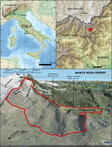
The study area is located at the top of the Lys and Sesia valleys, along the Valle d’Aosta and Piemonte regional border, on the southern side of the Monte Rosa massif (NW Italian Alps) (). The mapped area is approximately 7 km2, and its elevation ranges from 2505 to 4212 m a.s.l. (Piramide Vincent). A portion of the Monterosa Ski resort is situated within the mapped area, encompassing 115 km of ski tracks and 24 ski lifts, representing one of the largest Italian ski resorts. A high number of tourists are present in the area from summer to winter season, thanks to the presence of cable cars, ski tracks and trekking trails. Based on number of people using cable car facilities, 34,087 tourists reached Cimalegna plateau during pre-Covid19 summers (mean seasonal number, year 2017–2019, Monterosa Ski official data). Concerning winter seasons, a significant data is related to the high transit rate of skiers within the area: a mean number of 819,842 ‘passages’ of tourists using the three cable car facilities accessing the Cimalegna plateau (mean seasonal number, year 2017–2019, Monterosa Ski official data).
Figure 1. Location of the study area.
From a geological point of view, the study area is located in the inner side of the Alpine range, in the Pennidic Domain (Piana et al., Citation2017). According to the classification scheme of the Piemonte geological map (Lombardo et al., Citation2016), this consists of continental crust units, from the European continental margin, and oceanic crust units from the Ligure-Piemontese Ocean. The area is a significant tectonic intersection between major structural/paleogeographic domains of the Alpine orogen, with the presence (from north to south) of: (i) the Monte Rosa nappe (continental crust), constituted of garnets and chloritoid-rich micaschists, metabasites, orthogneiss, paragneiss and marbles; (ii) the ‘Zermatt-Saas’ and ‘Combin Zone’ units (oceanic crust), constituted of serpentinites, metagabbros, metabasites, metasediments and calcschists (CitationDal Piaz, 2001; Gasco et al., Citation2011; Handy et al., Citation2010; Piana et al., Citation2017; Steck et al., Citation2015).
According to recent climate series (2008–2017) obtained by the Col d’Olen AWS (Automatic Weather Station, Meteomont Service, Italian Army, 2900 m a.s.l., located close to the Angelo Mosso Institute), the area has a mean annual air temperature of –2.3°C, a mean cumulative annual snowfall of 818 cm, and a mean annual liquid precipitation of ca. 400 mm. Snow cover lasts for at least 8 months, reaching a maximum thickness of ca. 350 cm (Freppaz et al., Citation2019). The climatic classification based on the Köppen-Geiger scheme defines this area as Alpine Region, cold due to altitude (H) type (Fratianni & Acquaotta, Citation2017). The study area is exposed to the wet, Mediterranean air currents from S-SE, giving the presence of relatively low reliefs in-between the Po Valley and the study area (). The wet conditions of the area are in agreement with the findings of Isotta et al. (Citation2014), who reported a wet band extending along the southern rim of the Alps (towards the Po valley).
3. Methods
3.1. Data collection
The research work flow included both field and laboratory activities (years 2017–2019), either for survey and interpretation of geomorphological features or for creation of cartographic products within a Geographic Information System (GIS) geodatabase by means of Quantum GIS (QGIS) software, as follows ().
Figure 2. Workflow showing the working steps used to create the cartographic products. Details of each step are described in the text.
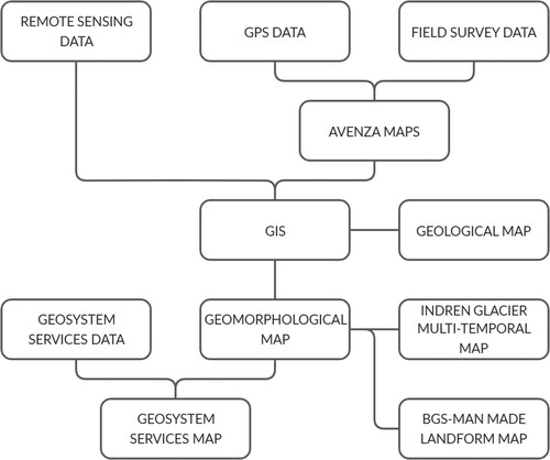
Data collection, analysis and digitalisation was carried out within GIS software, by using: two sets of orthoimages (years 2006 and 2015, www.pcn.minambiente.it), the Aosta Valley Region Digital Terrain Model (DTM)-Hillshade (2008, 2 m cell size), the Piemonte Region DTM-Hillshade (2009–2010, 5 m cell size), and the raster version of the regional technical map of Aosta Valley Region (2015, Carta Tecnica Regionale, 1:10,000 scale).
GPS-controlled digital field data have been collected using the Avenza Maps application (https://www.avenza.com/avenza-maps/) on tablet/smartphone during the summer 2018. Then geomorphologic features have been interpreted and mapped with the creation of a complete QGIS legend. Based on the above features, geosystem services have been identified, analysed, classified and mapped (scale 1:15,000).
As complementary information, existing geological maps elaborated by the Aosta Valley Region (http://geologiavda.partout.it/) and Leonoris et al. (Citation2008) have been merged into a simplified geological map (scale 1:15,000) whose legend structure is coherent with both national geomorphological and regional geological references (Campobasso et al., Citation2018; CitationDe Giusti et al., 2004; Lombardo et al., Citation2016; Piana et al., Citation2017). Depositional glacial landforms of Indren and Garstelet Glacier have been analysed by means of remote sensing data (high-resolution images and DTM’s (Lucchesi et al., Citation2013) and a multi-temporal map have been designed (scale 1:15,000). All these information have been merged and represented into the Main Map included in the supplemantary material.
3.2. Geomorphological and man-made landforms mapping
The geomorphological map was designed using the national standard for geomorphological mapping reported in the new Italian guidelines ‘Aggiornamento ed Integrazioni delle Linee Guida della Carta Geomorfologica d’Italia alla scala 1:50,000’ (Campobasso et al., Citation2018). In the guidelines, several geomorphological elements are proposed based on previous Italian Geological Survey Guidelines (Brancaccio et al., Citation1994). These guidelines provide detailed information for landforms, processes and deposits representation in different natural and anthropic environments and were chosen to offer a common interpretation base with other Italian geomorphological maps.
A QGIS-based geomorphological legend style was created to enhance the use of a unique style for all Italian geomorphological maps. Some elements of the legend were modified because of their graphic complexity and their consequent impossible recreation in QGIS style (e.g. trace of ancient glacial stream). Some others, as for example ‘pavement stone’”, have been created ad-hoc to represent features not yet classified in the guidelines.
3.3. Geosystem services
Two groups of values in the earth physical resources have been identified by Wilson (Citation1994): economic value in exploiting the physical resources of the planet and the cultural or heritage value in protecting the aesthetic and research resource of the physical environment. CitationGray (2004, Citation2013) developed this concept into the term ‘geodiversity’, identifying 25 geosystem services, described and classified in five groups. (i) Regulating services enclose atmospheric and oceanic processes, terrestrial processes, flood regulation and water quality regulation. (ii) Supporting services enclose soil processes, habitat provision, land and water as a platform for human activity, burial and storage. (iii) Provisioning services are those supplied from physical environment as valuable material goods for society (e.g. construction materials and gemstones). (iv) Cultural services encompass values given by society to some physical environment elements depending on their social and community meaning (e.g. environment quality, geotourism, artistic inspiration). (v) Knowledge services recognise the physical environment role as a laboratory for research and education.
4. Geomorphological analysis
4.1. Geomorphology
Landforms belonging to five main natural morphogenetic processes were mapped in the area together with anthropogenic ones.
4.1.1. Ice and snow related features
Two main glaciers characterise the northern part of the study area, along the slopes of the Piramide Vincent (4212 m a.s.l.): (i) the Indren Glacier covers a surface of ca. 0.9 km2 and its present-day terminus (2019) is at 3130 m a.s.l., (ii) the Garstelet Glacier covers a surface of ca. 0.2 km2 and its present-day terminus (2019) is located at an elevation of 3360 m a.s.l.
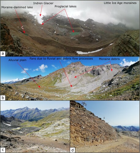
Several glacial lakes are present in the area and their formation is mainly linked to the recent glaciers retreat (as also reported by Viani et al., Citation2016). Numerous lakes are considered as proglacial lakes excluding the ice-contact lake on the small left lobe of the Indren Glacier and the Little Ice Age (LIA) moraine-dammed lake on the right side of Indren catchment at the confluence with the Garstelet creek ((a)).
Figure 3. (a) Panoramic picture of the Indren Glacier forefield where different moraine ridges are clearly visible and show different pulses of the glacier during the LIA. Several glacial lakes have formed here since the end of the LIA. (b) Glacial debris from the maximum pulse of the LIA are reworked by fluvial and gravitational processes that have led to fan and alluvial plains formation. (c) The active rock glacier at the Col d’Olen site (identified by the yellow dotted line). (d) Man-made landforms are widespread and in constant evolution within the study area. In the picture, the freshly excavated surface created for the building of the new Cimalegna-Passo dei Salati chairlift and slope is reported.
4.1.2. Glacial landforms
Glacial features are the most widespread landforms in the study area and suggest the main role of glaciers in shaping the geomorphological setting. Three main sectors can be distinguished. (i) The proglacial areas of the Indren and Garstelet glaciers present both erosional and depositional landforms, where different moraine systems are clearly visible and help reconstructing the LIA glacial pulsations ((b)), of which the maximum is dated 1845–1860 (Orombelli, Citation2011). Others historical extent of the glaciers have been reconstructed from data inventoried by the Italian Glaciological Committee (Salvatore et al., Citation2015, www.glaciologia.it). (ii) The south-western side of the study area is characterised by glacial deposits that allow identifying pre-LIA stages of the Indren and Garstelet glaciers, when they both constituted a singular glacial apparatus. (iii) On the Cimalegna plateau, in the south-eastern side of the investigated area, relict glacial features of both depositional and erosional origin are represented, although no information on their age is available.
4.1.3. Periglacial landforms
In the study area, the Alpine Permafrost Index Map (Boeckli et al., Citation2012) shows that permafrost conditions could be largely diffused at elevations higher than ca. 2700 m a.s.l. Protalus ramparts are the most widespread landforms of the periglacial landforms group. A number of rock glaciers are present on west/north-west facing slopes. Active rock glaciers ((c)) show an average elevation of their fronts of ca. 2830 m a.s.l. and the lowest one is at 2710 m a.s.l., thus possibly indicating the elevation of the lower limit of discontinuous permafrost in the area. Numerous well-preserved periglacial features, such as blockfields and blockstreams, are located on the Stolemberg and Cimalegna plateau, at elevations higher than 2780 m a.s.l. Their presence might indicate that this area was a nunatak or was located below a cold-base glacier during the LGM (Ballantyne Colin, Citation2018), a suitable condition based on regional reconstruction of quaternary glaciation in the Western Italian Alps (Carraro & Giardino, Citation2004).
4.1.4. Fluvial and fluvioglacial landforms
Erosional fluvial landforms are strictly linked to glacial torrents. Depositional landforms are mainly represented by proglacial/alluvial fans and plains, where mostly glacial deposits have been reworked and deposited ((b)).
4.1.5. Gravitational landforms
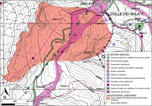
Both erosional and depositional gravitational landforms testify the most recent and active morphogenetic agent. They are mainly linked to rock fall/toppling and debris flow processes ((b)). Sackung trenches and scarps highlight two main deep-seated gravitational slope deformations, one on the ridge dividing the Indren and Bors glaciers (north of Stolemberg) and the other on the left side of the Indren catchment (on the south-east sector of Passo dei Salati).
4.1.6. Man-made landforms
Despite the location of the case study in a remote high mountain environment, several man-made landforms (e.g. hydro-electric power plants, high mountain huts, ski resort facilities) are distributed in the investigated area within the Passo dei Salati – Cimalegna plateau sector of the Monterosa Ski resort ((d)).
4.2. Geosystem services
The geosystem services were described and classified in five main groups.
4.2.1. Regulation services
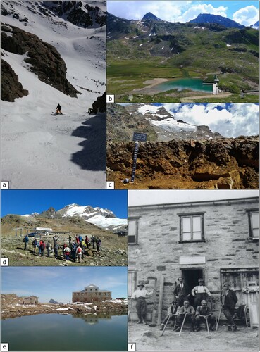
The Monte Rosa massif plays an important role in terrestrial processes (tectonic and erosional processes). Numerous mapped elements are glacial creeks that drive the erosion and downstream transport mechanism of glacial debris ((a)). Flood regulation role is recognised both for natural (e.g. alluvial/proglacial plain) ((b)) and man-made (e.g. dams) landforms.
Figure 4. (a) The Eagle Couloir, an attractive freeride run that provides an important leisure service. Below the snowpack, the Indren creek plays an important role in terrestrial processes. (b) In the lowermost portion of the study area, different services can be identified: the alluvial plain have a significant effect in flood regulation; the dam collects meltwater from the Indren and Garstelet glaciers that is channelled to the Gabiet dam where it is used for hydroelectrical purposes; on the ridge, the pylons of the Gabiet-Passo Salati bubble-car highlight the supporting service supplied by the topography to ski resort facilities. (c) Thick soil layer on Stolemberg Plateau. (d) Geoturism is well developed in the Passo dei Salati and Cimalegna Plateau along the geologic-pedologic path. Along this path, a seismic station and a permafrost monitoring borehole are visible and are examples of the environmental monitoring activities performed in the area. Numerous activities are promoted by local municipalities and the Sesia Valgrande UNESCO Global Geopark. (e) The Angelo Mosso Institute is the hotspot of knowledge services within the area. It is the symbol of the historical scientific research carried out on the Monte Rosa massif since the beginning of twentieth century. Nowadays it is part of the LTER network and is the hub for numerous environmental studies and monitoring activities. (f) Late 1920s, a group of researchers leaded by Umberto Monterin (left of the door) in front of the Geophysical Observatory connected to the Mosso Institute.
4.2.2. Supporting services
The study area is almost entirely encompassed in different protected areas highlighting its environmental value. The Sesia Val Grande UNESCO Global Geopark, the ‘Alta Valsesia’ Special Protection Zone (Piemonte) and the ‘Glacial environment of Monte Rosa massif’ (Valle d’Aosta) are mapped as habitat provision services. Land as basis for human activities is strongly linked to ski resort activities (lift stations and pylons) ((b)) and mountaineering (mountain huts). Pedogenised areas, identified as areas with well-developed soil, are recognised especially in the Stolemberg ((c)) and Cimalegna plateau, where they sustain generally poorly developed vegetation. Finally, glaciers and lakes play a relevant role as freshwater reservoirs, feeding valley streams and aquifers.
4.2.3. Provisioning services
Hydroelectric power plant can be classified as ‘fuel services’. In the area, the meltwater from the Indren Glacier is collected ((b)) and conveyed to the major Gabiet dam. Furthermore, the Stolemberg sector has been important for industrial mineral production with its gold ore.
4.2.4. Cultural services
The geological and geomorphological diversity, combined with the presence of glaciers and lakes, gives to this area a high value in term of environmental quality. Leisure activities are practiced both in summer (geotourism, hiking, climbing, and mountaineering) ((d)) and winter (skiing, off-track skiing, and ski-touring) ((a)). Moreover, it has to be conserved that the case study in within the area originally settled by Walser colonist from Valais (Switzerland) during the fourteenth-century. Since then, the Walser community has preserved its Alemanic language, culture and architecture, strictly connected to the climatic/glacial variations (medieval climatic optimum) that occurred in the area (Fibicher, Citation1983; Fibihcer, Citation1987; Stroppa, Citation2002). Finally, numerous religious symbols (e.g. chapels, roods) are spread in the area.
4.2.5. Knowledge services
The Monte Rosa massif has been the object of several scientific studies aiming at the reconstruction of the geological history, the structural and paleogeographic setting and on the rock-forming processes of the Western Alps. Moreover, meteorological and glaciological data series for the area are available since 1926 thanks to the research activities based at the Mosso Institute ((f)). Nowadays, the Institute is part of the LTER network and continues to support a large number of researchers, whose activity is devoted to the study of different topics such as the effects of climate change on mountain ecosystems, impacts of cryosphere degradation on water quality, characteristics of alpine soils and their relationships with alpine vegetation, snow dynamics and avalanches. The Mosso Institute has become a symbol of the history of scientific research in the area since 1907 ((e)) and an important museum for historical and modern research on the Monte Rosa massif. In terms of education and employment, the most important role is played by the Sesia Val Grande UNESCO Global Geopark, which promotes education and dissemination activities (Perotti et al., Citation2020).
4.3 . Geomorphology-geosystem services connection
A two-way connection between geomorphology and geosystem services emerges from this analysis. On one hand, there are geomorphological features that need to be preserved because of their important role for society. Well-determined geosystem services have been assigned to specific geomorphological elements highlighting the first connection. This is the case of glaciers and lakes, well-identifiable geomorphological elements, that provides a specific service as freshwater reservoirs ((a)). Another example is given by fluvial and fluvioglacial landforms that offer regulating services such as terrestrial processes and flood regulation ((b)). On the other hand, there are services that can be threatened by active geomorphological agents. The GIS analyses of the interaction with geosystem services that involve human presence underline the potential critical connection with active geomorphological features (). In the study area, this is a well-known problem for the ski resort area () but less considered for trails, mountaineering routes and off-piste ski itineraries. In a context of sustainable development, the analysis of geosystem services and their mapping can be an important tool for stakeholders engaged in the management of high-mountain environments modified by climate change and human activities. Geosystem services maps could be also a relatively easy tool for disentangling and representing the connection between humans and nature, helping in both natural hazards and resources assessment.
Figure 5. (a) A first example of connection between geomorphology and geosystem services is represented by glaciers and lakes. In the study area, the Indren and Garstelet glaciers and their forefields represents an important water reservoir that need to be preserved and protected to guarantee good water quality. (b) The second example is represented by fluvial landforms that characterises the lower part of the study area along the Indren creek (ENDREBACH in the map). They play an important role as regulating services such as terrestrial processes for creek features and flood control for alluvial plains.
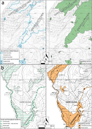
Figure 6. The table report the percentage of geosystem service features (by type of shape) that interact with potentially dangerous geomorphological elements (by morphogenetic agent). Red cells represent the high percentage of interactions between linear services and geomorphological features. In the study area this kind of service is linked to geotourism and leisure activity that cross over a large number of environments and are therefore more exposed to different risks.
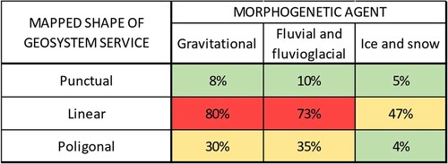
Figure 7. An example of potential dangerous interaction is reported as the deep-seated gravitational slope deformation, identified on the Passo dei Salati area, interacting with the geosystem services linked to human presence such as ropeways installations and access routes, ski slopes, geotouristic/trekking itineraries and panoramic spots.
5. Conclusion
The analysis of landforms and morphogenetic processes of the study area was carried out through interpretation of digital orthoimages and digital terrain models integrated with detailed field data collection. This activity led to the creation of a detailed geomorphological map with more than 1100 elements. The geomorphological evolution of this high-mountain area has been mainly driven by glacial processes, although erosional and depositional landforms related to gravitational processes currently represent the most active geomorphic agents in the area. The preservation of periglacial landforms such as blockfields and blockstreams on the Stolemberg and Cimalegna plateau may indicate that this site was a nunatak or was located below a cold-base glacier during the LGM. In addition to the geomorphological analysis of natural landforms, the developed geomorphological map served as background knowledge for geosystem services analyses and mapping. From the comparison of the geomorphological and geosystem services maps emerged a two-way connection between natural and anthropized environment, highlighting its value in a sustainable mountain area management.
Software
The data processing procedures and all the development necessary to elaborate the map were performed using QGIS 3.4.5. The layout used for creating the A0+ map and the final map layout were produced also using QGIS 3.4.5. Figures in the paper and in the layout, and new vector symbology for some symbol modification were created and adjusted using INKSCAPE free desktop software. All the symbols used for this map (geomorphological and geosystem services) are developed and distributed as free and available at www.geositlab.unito.it/jom.
Jom_REV3.pdf
Download PDF (56.7 MB)Acknowledgements
The authors are very grateful to Monterosa 2000, all the municipalities, managers of the ski resort areas, associations and funders as mentioned along the text. Moreover, they are grateful to the students and researchers using the Angelo Mosso Institute, the visiting groups and to everybody contributing in enhancing the valorisation of the area. This project was supported by the ERASMUS+ project GEOclimHOME-PRO – Geoheritage and climate change for highlighting the professional perspective, grant 2018–1 -FI01-KA201-047206 (European fundings) and the GEODIVE – Compagnia San Paolo bank foundation in partnership with University of Torino, under the funding program 2016; the project “GeoDIVE—From rocks to stones, from landforms to landscapes” was funded with grant #CSTO169034 (Regional funding).
Disclosure statement
No potential conflict of interest was reported by the author(s).
Additional information
Funding
Related Research Data
References
- Auer, I., Böhm, R., Jurkovic, A., Lipa, W., Orlik, A., Potzmann, R., Schöner, W., Ungersböck, M., Matulla, C., Briffa, K., & Jones, P. (2007). HISTALP—historical instrumental climatological surface time series of the Greater Alpine Region. International Journal of Climatology, 27(1), https://doi.org/https://doi.org/10.1002/joc.1377
- Ballantyne Colin, K. (2018). Periglacial geomorphology. Wiley-Blackwell. 472 pp.
- Beniston, M. (2005). Mountain climates and climatic change: An overview of processes focusing on the European Alps. Pure and Applied Geophysics, 162(8), https://doi.org/https://doi.org/10.1007/s00024-005-2684-9
- Beniston, M., Farinotti, D., Stoffel, M., Andreassen, L. M., Coppola, E., Eckert, N., Fantini, A., Giacona, F., Hauck, C., Huss, M., & Huwald, H. (2018). The European mountain cryosphere: a review of its current state, trends, and future challenges. The Cryosphere, 12(2), 759–794. https://doi.org/https://doi.org/10.5194/tc-12-759-2018
- Boeckli, L., Brenning, A., Gruber, S., & Noetzli, J. (2012). Permafrost distribution in the European Alps: calculation and evaluation of an index map and summary statistics. The Cryosphere, 6(4), 807–820. https://doi.org/https://doi.org/10.5194/tc-6-807-2012
- Bollati, I. M., Cerrato, R., Crosa Lenz, B., Vezzola, L., Giaccone, E., Viani, C., Zanoner, T., Azzoni, R. S., Masseroli, A., Pellegrini, M., Scapozza, C., Zerboni, A., & Guglielmin, M. (2018). Geografia Fisica e Dinamica Quaternaria, https://doi.org/https://doi.org/10.4461/GFDQ.2018.41.16
- Bollati, I., Crosa Lenz, B., Zanoletti, E., & Pelfini, M. (2017). Geomorphological mapping for the valorization of the alpine environment. A methodological proposal tested in the Loana Valley (Sesia Val Grande Geopark, Western Italian Alps). Journal of Mountain Science, 14(6), 1023–1038. https://doi.org/https://doi.org/10.1007/s11629-017-4427-7
- Brancaccio, L., Castiglioni, G. B., Chiarini, E., Cortemiglia, G., D’Orefice, M., Dramis, F., Graciotti, R., La Posta, E., Lupia Palmieri, E., Onorati, G., Panizza, M., Pannuzi, L., Papasodaro, F., & Pellegrini, G. B. (1994). Carta Geomorfologica d’Italia – 1:50.000. Guida al rilevamento. (Quaderni del Servizio Geologico Nazionale, Ser. III, 4), 42 pp.
- Bruno, D. E., Crowley, B. E., Gutak, J. M., Moroni, A., Nazarenko, O. V., Oheim, K. B., Ruban, D. A., Tiess, G., & Zorina, S. O. (2014). Paleogeography as geological heritage: Developing geosite classification. Earth-Science Reviews, 138, 300–312. https://doi.org/https://doi.org/10.1016/j.earscirev.2014.06.005
- Campobasso, C., Carton, A., Chelli, A., D’Orefice, M., Dramis, F., Graciotti, R., Guida, D., Pambianchi, G., Peduto, F., & Pellegrini, L. (2018). Carta Geomorfologica d’Italia – 1:50.000. Aggiornamento ed integrazioni delle linee guida della Carta Geomorfologica d’Italia alla scala 1:50.000. (Quaderni del Servizio Geologico d’Italia, Ser. III, 13, ), 98 pp.
- Carraro, F., & Giardino, M. (2004). Quaternary glaciations in the western Italian Alps - a review. In J. Ehlers, & P. L. Gibbard (Eds.), Quaternary Glaciations - extent and chronology (pp. 201–208). Elsevier B.V.
- Colombo, N., Bocchiola, D., Martin, M., Confortola, G., Salerno, F., Godone, D., D’Amico, M. E., & Freppaz, M. (2019). High export of nitrogen and dissolved organic carbon from an Alpine glacier (Indren Glacier, NW Italian Alps). Aquatic Sciences, 81(4), https://doi.org/https://doi.org/10.1007/s00027-019-0670-z
- Colombo, N., Ferronato, C., Vittori Antisari, L., Marziali, L., Salerno, F., Fratianni, S., D’Amico, M. E., Ribolini, A., Godone, D., Sartini, S., Paro, L., di Cella U., M., & Freppaz, M. (2020). CATENA.
- Colombo, N., Giaccone, E., Paro, L., Buffa, G., D’Agata, C., & Fratianni, S. (2016). Geogr. Fis. Dinam. Quat, https://doi.org/https://doi.org/10.4461/GFDQ.2016.39.3
- Colombo, N., Gruber, S., Martin, M., Malandrino, M., Magnani, A., Godone, D., Freppaz, M., Fratianni, S., & Salerno, F. (2018). Rainfall as primary driver of discharge and solute export from rock glaciers: The Col d'Olen Rock Glacier in the NW Italian Alps. Science of the Total Environment, 639, https://doi.org/https://doi.org/10.1016/j.scitotenv.2018.05.098
- Colombo, N., Paro, L., Godone, D., & Fratianni, S. (2016). Geomorphology of the Hohsand basin (Western Italian Alps). Journal of Maps, 12(5), 975–978. https://doi.org/https://doi.org/10.1080/17445647.2015.1105762
- Colombo, N., Salerno, F., Martin, M., Malandrino, M., Giardino, M., Serra, E., Godone, D., Said-Pullicino, D., Fratianni, S., Paro, L., Tartari, G., & Freppaz, M. (2019). Influence of permafrost, rock and ice glaciers on chemistry of high-elevation ponds (NW Italian Alps). Science of the Total Environment, 685, 886–901. https://doi.org/https://doi.org/10.1016/j.scitotenv.2019.06.233
- Colombo, N., Sambuelli, L., Comina, C., Colombero, C., Giardino, M., Gruber, S., Viviano, G., Antisari, L. V., & Salerno, F. (2018). Mechanisms linking active rock glaciers and impounded surface water formation in high-mountain areas. Earth Surface Processes and Landforms, 43, 417–431. https://doi.org/https://doi.org/10.1002/esp.4257
- Dal Piaz, G. V. (2001). Geology of the Monte Rosa massif: historical review and personal comments. Schweiz Min., 81, 275.
- De Giusti, F., Dal Piaz, G. V., Massironi, M., & Schiavo, A. (2004). Carta geotettonica della Valle d’Aosta. SciGeol., 55, 129.
- Dramis, F., Guida, D., & Cestari, A. (2011). Nature and aims of geomorphological mapping. In M. J. Smith, P. Paron, & J. Griffiths (Eds.), Geomorphological mapping: Methods and applications (pp. 39–73). Elsevier.
- Fibicher, A. (1983). Walliser Geschichte (Vol. 1), Von den ersten bauern zu den alemannen. Kantonales Erziehungsdepartement Sion. 120 pp.
- Fibihcer, A. (1987). Walliser Geschichte (Vol. 2), hoch- und spätmittelalter. Kantonales Erziehungsdepartement Sion. 251 pp.
- Fratianni, S., & Acquaotta, F. (2017). The climate of Italy. In M. Soldati, & M. Marchetti (Eds.), Landscapes and landforms of Italy. (world geomorphological landscapes 1) (pp. 29–38). Springer International Publishing. https://doi.org/https://doi.org/10.1007/978-3-319-26194-2_4.
- Freppaz, M., Viglietti, D., Balestrini, R., Lonati, M., & Colombo, N. (2019). Climatic and pedoclimatic factors driving C and N dynamics in soil and surface water in the alpine tundra (NW-Italian Alps). Nature Conservation, 34, 67–90. https://doi.org/https://doi.org/10.3897/natureconservation.34.30737
- Gasco, I., Borghi, A., & Gattiglio, M. (2011). P–T Alpine metamorphic evolution of the Monte Rosa nappe along the Piedmont Zone boundary (Gressoney Valley, NW Italy). Lithos, 127(1-2), 336–353. https://doi.org/https://doi.org/10.1016/j.lithos.2011.09.007
- Gobiet, A., Kotlarski, S., Beniston, M., Heinrich, G., Rajczak, J., & Stoffel, M. (2014). 21st century climate change in the European Alps – A review. Science of The Total Environment, 493, 1138. https://doi.org/https://doi.org/10.1016/j.scitotenv.2013.07.050
- Gray, M. (2004). Geodiversity; valuing and conserving abiotic nature. John Wiley & Sons, Chichester. 448 pp.
- Gray, M. (2008). Geodiversity: The origin and evolution of a paradigm. In C. V. Burek, & C. D. Prosser (Eds.), The history of geoconservation (pp. 31–36). Geological Society of London Special Publication 300.
- Gray, M. (2013). Geodiversity: Valuing and conserving abiotic nature, second edition. Wiley Blackwell. 508 pp.
- Handy, M. R., Schmid, S. M., Bousquet, R., Kissling, E., & Bernoulli, D. (2010). Reconciling plate-tectonic reconstructions of Alpine Tethys with the geological–geophysical record of spreading and subduction in the Alps. Earth-Science Reviews, 102(3-4), 121–158. https://doi.org/https://doi.org/10.1016/j.earscirev.2010.06.002
- Hansen, J., & Sato, M. (2016). Regional climate change and national responsibilities. Environmental Research Letters, 11(3), 034009. https://doi.org/https://doi.org/10.1088/1748-9326/11/3/034009
- Harris, C., Arenson, L. U., Christiansen, H. H., Etzelmüller, B., Frauenfelder, R., Gruber, S., Haeberli, W., Hauck, C., Hoelzle, M., Humlum, O., & Isaksen, K. (2009). Permafrost and climate in Europe: Monitoring and modelling thermal, geomorphological and geotechnical responses. Earth-Science Reviews, 92(3-4), 117. https://doi.org/https://doi.org/10.1016/j.earscirev.2008.12.002
- Hearn, G. J., & Hart, A. B. (2011). Geomorphological contributions to landslide risk assessment: Theory and practice. In M. J. Smith, P. Paron, & J. Griffiths (Eds.), Geomorphological mapping: Methods and applications (pp. 107–148). Elsevier.
- Huggel, C., Salzmann, N., Allen, S., Caplan-Auerbach, J., Fischer, L., Haeberli, W., Larsen, C., Schneider, D., & Wessels, R. (2010). Recent and future warm extreme events and high-mountain slope stability. Philosophical Transactions of the Royal Society A: Mathematical, Physical and Engineering Sciences, 368, 2435. https://doi.org/https://doi.org/10.1098/rsta.2010.0078
- IPCC. (2019). IPCC special report on the ocean and cryosphere in a changing climate: Summary for policymakers. Retrieved October 2019. https://report.ipcc.ch/srocc/pdf/SROCC_SPM_Approved.pdf. .
- Isotta, F. A., Frei, C., Weilguni, V., Perčec Tadić, M., Lassègues, P., Rudolf, B., Pavan, V., Cacciamani, C., Antolini, G., Ratto, S. M., Munari, M., Micheletti, S., Bonati, V., Lussana, C., Ronchi, C., Panettieri, E., Marigo, G., & Vertačnik, G. (2014). The climate of daily precipitation in the Alps: development and analysis of a high-resolution grid dataset from pan-Alpine rain-gauge data. International Journal of Climatology, 34(5), 1657–1675. https://doi.org/https://doi.org/10.1002/joc.3794
- Lambiel, C., Maillard, B., Kummert, M., & Reynard, E. (2016). Geomorphology of the Hérens valley (Swiss Alps). Journal of Maps, 12(1), 160–172. https://doi.org/https://doi.org/10.1080/17445647.2014.999135
- Leonoris, C., Freppaz, M., Caimi, A., Filippa, G., Dal Piaz, G. V., Dal Piaz, G., & Schiavo, A. (2008) Parco Naturale Alta Valsesia, percorso geologico-pedologico di Cimalegna. (Opuscolo informativo, Regione Piemonte Assessorato Ambiente, 2008), 33 pp.
- Lombardo, V., Piana, F., Fioraso, G., Irace, A., Mimmo, D., Mosca, P., Tallone, S., Barale, L., Morelli, M., & Giardino, M. (2016). The Classification Scheme of the Piemonte Geological Map and the OntoGeonous initiative. Rendiconti Online della Società Geologica Italiana, 39, 117–120. https://doi.org/https://doi.org/10.3301/ROL.2016.61
- Lucchesi, S., Bertotto, S., Chiarle, M., Fioraso, G., Giardino, M., & Nigrelli, G. (2019). Little ice age glacial systems and related natural instability processes in the Orco Valley (North-Western Italy). Journal of Maps, 15(2), 142–152. https://doi.org/https://doi.org/10.1080/17445647.2018.1564382
- Lucchesi, S., Fioraso, G., Bertotto, S., & Chiarle, M. (2014). Little ice age and contemporary glacier extent in the Western and South-Western Piedmont Alps (North-Western Italy). Journal of Maps, 10(3), 409–423. https://doi.org/https://doi.org/10.1080/17445647.2014.880226
- Lucchesi, S., Giardino, M., & Perotti, L. (2013). Applications of high-resolution images and DTMs for detailed geomorphological analysis of mountain and plain areas of NW Italy. European Journal of Remote Sensing, 46(1), 216–233. https://doi.org/https://doi.org/10.5721/EuJRS20134612
- Magnani, A., Viglietti, D., Balestrini, R., Williams, M. W., & Freppaz, M. (2017). Contribution of deeper soil horizons to N and C cycling during the snow-free season in alpine tundra, NW Italy. Catena, 155, 75–85. https://doi.org/https://doi.org/10.1016/j.catena.2017.03.007
- Mania, I., Gorra, R., Colombo, N., Freppaz, M., Martin, M., & Anesio, A. M. (2019). Prokaryotic Diversity and Distribution in Different Habitats of an Alpine Rock Glacier-Pond System. Microbial Ecology, 78(1), 70–84. https://doi.org/https://doi.org/10.1007/s00248-018-1272-3
- Orombelli, G. (2011). Holocene mountain glacier fluctuations: a global overview. Geografia Fisica e Dinamica Quaternaria, 34(1), 17–24. https://doi.org/https://doi.org/10.4461/GFDQ.2011.34.2
- Pepin, N., Bradley, R., Diaz, H., Baraer, M., Caceres, E.B., Forsythe, N., Fowler, H., Greenwood, G., Hashmi, M.Z., Liu, X.D., Miller, J.R., Ning, L., Ohmura, A., Palazzi, E., Rangwala, I., Schöner, W., Severskiy, I., Shahgedanova, M., Wang, M.B., Williamson, S., & Yang, D.Q., (2015). Elevation-dependent warming in mountain regions of the world. Nature Climate Change, 5, 424–430. https://doi.org/https://doi.org/10.1038/nclimate2563
- Perotti, L., Bollati, I. M., Viani, C., Zanoletti, E., Caironi, V., Pelfini, M., & Giardino, M. (2020). Fieldtrips and Virtual Tours as Geotourism Resources: Examples from the Sesia Val Grande UNESCO Global Geopark (NW Italy). Resources, 9(6), 63. https://doi.org/https://doi.org/10.3390/resources9060063
- Perotti, L., Carraro, G., Giardino, M., De Luca, D. A., & Lasagna, M. (2019). Geodiversity Evaluation and Water Resources in the Sesia Val Grande UNESCO Geopark (Italy). Water, 11(10), 2102. https://doi.org/https://doi.org/10.3390/w11102102
- Piana, F., Fioraso, G., Irace, A., Mosca, P., d’Atri, A., Barale, L., Falletti, P., Monegato, G., Morelli, M., Tallone, S., & Vigna, G. B. (2017). Geology of Piemonte region (NW Italy, Alps–Apennines interference zone). Journal of Maps, 13(2), 395–405. https://doi.org/https://doi.org/10.1080/17445647.2017.1316218
- Pintaldi, E., D’Amico, M. E., Colombo, N., Colombero, C., Sambuelli, L., De Regibus, C., Franco, D., Perotti, L., Paro, L., & Freppaz, M.. (2021). Hidden soils and their carbon stocks at high-elevation in the European Alps (North-West Italy). CATENA, 198. https://doi.org/https://doi.org/10.1016/j.catena.2020.104700
- Roberti, G., Ward, B., van Wyk de Vries, B., Friele, P., Perotti, L., Clague, J. J., & Giardino, M. (2018). Precursory slope distress prior to the 2010 Mount Meager landslide, British Columbia. Landslides, 15(4), 637–647. https://doi.org/https://doi.org/10.1007/s10346-017-0901-0
- Salvatore, M. C., Zanoner, T., Baroni, C., Carton, A., Banchieri, F. A., Viani, C., Giardino, M., & Perotti, L. (2015). Geografia Fisica e Dinamica Quaternaria, 175–198. https://doi.org/https://doi.org/10.4461/GFDQ.2015.38.16
- Schrodt, F., Bailey, J. J., Kissling, W. D., Rijsdijk, K. F., Seijmonsbergen, A. C., Van Ree, D., Hjort, J., Lawley, R. S., Williams, C. N., Anderson, M. G., & Beier, P. (2019). Opinion: T advance sustainable stewardship, we must document not only biodiversity but geodiversity. Proceedings of the National Academy of Sciences, 116(33), 16155–16158. https://doi.org/https://doi.org/10.1073/pnas.1911799116
- Serrano, E., & Gonzalez-Trueba, J. R. (2005). Assessment of geomorphosites in natural protected areas: the Picos de Europa National Park (Spain). Géomorphologie: Relief, Processus, Environnement, 11(3), 197–208. https://doi.org/https://doi.org/10.4000/geomorphologie.364
- Serrano, E., & Ruiz-Flaño, P. (2007). Geodiversity : a theoretical and applied concept. Geographica Helvetica, 62, 140. https://doi.org/https://doi.org/10.5194/gh-62-140-2007
- Steck, A., Masson, H., & Robyr, M. (2015). Tectonics of the Monte Rosa and surrounding nappes (Switzerland and Italy): Tertiary phases of subduction, thrusting and folding in the Pennine Alps. Swiss Journal of Geosciences, 108(1), 3–34. https://doi.org/https://doi.org/10.1007/s00015-015-0188-x
- Stroppa, C. (2002). La cultura del popolo Walser delle alpi. Franco Angeli. 176 pp.
- Viani, C., Giardino, M., Huggel, C., Perotti, L., & Mortara, G. (2016). An overview of glacier lakes in the Western Italian Alps from 1927 to 2014 based on multiple data sources (historical maps, orthophotos and reports of the glaciological surveys). Geografia Fisica e Dinamica Quaternaria, 39(2), 203–214. https://doi.org/https://doi.org/10.4461/GFDQ.2016.39.19
- Viani, C., Machguth, H., Huggel, C., Godio, A., Franco, D., Perotti, L., & Giardino, M. (2020). Potential future lakes from continued glacier shrinkage in the Aosta Valley Region (Western Alps, Italy). Geomorphology, 355. https://doi.org/https://doi.org/10.1016/j.geomorph.2020.107068.
- Vione, D., Colombo, N., Said-Pullicino, D., Bocchiola, D., Confortola, G., Salerno, F., Viviano, G., Fratianni, S., Martin, M., Godone, D., & Freppaz, M. (2021). Seasonal variations in the optical characteristics of dissolved organic matter in glacial pond water. Science of The Total Environment, 759), https://doi.org/https://doi.org/10.1016/j.scitotenv.2020.143464
- Wilson, C. (1994). Earth heritage conservation. Geological Society. 272 pp.
- Zwolinski, Z. (2009). The routine of landform geodiversity map design for the Polish Carpathian Mts. Landform Analysis, 11, 77–85.