
ABSTRACT
Landslides inventories are crucial documents for extrapolating the spatial distribution of landslides that occurred in the past. However, the production of landslide hazards maps also needs deepening the knowledge on the temporal distribution of landslide activity. In this regard, historical maps and archive documents represent important sources of data and information on territory evolution through time and especially on landslides occurrence. Nevertheless, these kinds of data sources are rarely considered as they often must be interpreted integrating different disciplines. This work shows how historical and geomorphological data on landslides occurrence in an area of the Northern Apennines can be integrated to produce a synthesis map. This synthesis map put together analogic and digital information allowing to delineate the landscape evolution, in terms of spatial and especially temporal changes occurred in the study area representing a tool that could be useful for the landslide hazard assessment in territory management.
1. Introduction
Since the end of the last century, in Italy, the historical maps and archive documents received attention as source of data for urbanistic planning, and, mainly, for territory and landscape management purposes (Poli, Citation2001). Already in 1995, the Liguria Region administration realised the Historical Cartographic Archive (Regione Liguria, Citation2019) through the digitalization of historical maps that since then were kept in local archives spread in the Region. This powerful tool greatly supported actions of territorial management and the updating of the Technical Regional Topographic Map. Nowadays, digitalization campaigns of historical cartography are really massive in Italy and often, sources are accessible from regional cartographic internet portals.
At the same time, a growing cultural interest for the historical maps, not always restricted to professionals, developed in different countries, as also witnessed by the following initiatives: the Rumsey Historical Map Collection (Citation2019), from 2000, CitationOldMapsOnline (Citation2019), MAPIRE (Biszak et al., Citation2014), CitationCartoMundi (Citation2019). Interest in historical cartography as source for reconstructing geographies of the past has further increased since the growth of the concept of Historical Geographic Information System (Bailey & Schick, Citation2009; Gregory & Healey, Citation2007), both in the academic community and for educational purposes. This change is also due to the so-called Spatial Turn which has occurred in the human sciences (Withers, Citation2009) over the past 15 years. Building Historical GIS mainly has meaning contextualizing geographically (using essentially modern cartographic supports) historical elements of various nature and in relation to each other (archaeological sites, monuments, cultural heritage, areas of valuable landscape, also commercial and knowledge flows, etc.), while more rarely maps have been used as real historical sources. This trend appears to have recently reversed (Grava et al., Citation2020).
In Italy, historical maps have been employed both for hydrogeological risk management and for the analysis and management of geomorphological hazards and risks (Belardi & Zanichelli, Citation2011; Bonardi & Mastrovito, Citation2020; Carallo, Citation2020; Cencetti et al., Citation2020; Faccini et al., Citation2016; Giardino et al., Citation2015; Lazzari, Citation2014; Luino et al., Citation2018; Masotti, Citation2017; Paliaga et al., Citation2019; Piana et al., Citation2019; Piastra, Citation2015; Tacconi Stefanelli et al., Citation2016; Zanichelli, Citation2011). For these purposes, historical maps were used usually together with field data, photos and documents from archives and toponymic data (Cassi, Citation2009; Valbona & Gabellieri, Citation2016).
The Historical Archive of Landslides of the Emilia-Romagna Region (Regione Emilia-Romagna, Citation2019a) uses as data source scientific papers, historical and naturalistic books, technical reports and warnings from the territorial administrations but also local and national newspapers and websites (Regione Emilia-Romagna, Citation2019b). The direct reference with the historical maps (especially those issued before 1850) among the sources employed in the database of the archive is lacking, despite the relevance of this type of documents, currently recognized worldwide (Cevasco et al., Citation2009; Cevasco & Cevasco, Citation2013; Diodato et al., Citation2017; Murakami et al., Citation2014).
The limited use of these maps is mainly due to the following reasons:
historical maps are often difficult to find, and their research is a time-consuming activity;
they need specific archival and historical competence in addition to the knowledge of the implied social, technical and communicative aims that are necessary to extract and actualize the information (Harley, Citation2001; Poli, Citation2001);
some difficulties rising in the management of the historical maps by means of the GIS platforms: they have often ancient, inhomogeneous and extremely variable scales, they have not-orthogonal perspectives and often show ancient relief representations (e.g. the contour lines were introduced only during the Napoleonic period; Rossi, Citation2018).
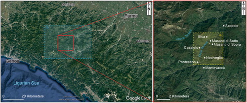
The aim of this work is to try to overcome these limitations carrying out a geomorphological-historical study (termed ‘geo-historical’ in this research), which integrates data from landslide inventory maps, historical maps and archives. The resulting synthesis map can be used as a tool that contributes to hydrogeological hazard and risk assessment at the local and sub-regional scales. The geo-historical synthesis map is presented through the case study of the Casaleto-Illica landslide, in the Ceno Valley (Bedonia district, Northern Apennines, Italy) ().
Figure 1. Location sketch of the study area. The dashed blue rectangle (A) refers to the position of , whereas the yellow one (B) refers to the position of .
2. Study area
The geological features of the surroundings of the Casaleto-Illica landslide are determined by the Helminthoid Flysch (Upper Campanian-Maastrichtian) made by grey limestones, marly limestones and marls turbidites arranged in thin to very thick beds that stratigraphically pass to black clay arranged in thin to medium beds (Elter et al., Citation2005). The Helminthoid Flysch is one of the more widespread formation pertaining to the Ligurian units of the northern Apennines, the orogenic belt with fold-thrust structures developed during the collisional phase, that took place from the Cenozoic, with the eastwards advancement and thrusting of the Ligurian units onto the Tuscan-Umbria units (Molli, Citation2008).
The outcropping rocks rich in clay and marls have played the role as predisposing factor of landslides that are the main geomorphological processes of the area. Instead, the rainfall and the undermining of the slopes, caused by the erosion of the torrents, are the main trigger factors of the landslides that are of different types, chiefly rock/earth rotational or translational slides and earth flows (for details, Main map, section ‘B’). The mean annual cumulative precipitation in the area is around 1400–1500 mm while the mean annual air temperature is around 9–10 °C (Antolini et al., Citation2017). Heavy rainfall events may occur in the area due to high-intensity thunderstorms with more than 300 mm of cumulative precipitation in 6 h (Segadelli et al., Citation2020). Low-intensity earthquakes characterize the northern Apennines, seldom larger ones exceeded M5.5 (Bennett et al., Citation2012), therefore they play a limited role as landslide trigger factor (Tosatti et al., Citation2008).
3. Materials and methods
The construction of the geo-historical synthesis map was preceded by three phases: (1) bibliographic research, aimed at finding textual documentation concerning historical events related to the Casaleto-Illica landslide; (2) archival research, aimed in particular at obtaining information through details contained in the historical cartography preserved in the Parma State Archives (ASPr); (3) verifying the match between data taken from bibliographic and archival/cartographic sources. The bibliographic starting point is provided by the description of the landslide by Roberto Almagià (1884–1962) in Studi geografici sulle frane in Italia (Citation1907, p. 86).
Other relevant historical textual sources (in regressive order) are: a memory written by the priest D. Giovanni Draghi (1824-1890); parts of this memory, datable at the second half of the nineteenth century, are available online (Seminario Bedonia, Citation2019); the critical evaluation of the source is limited by the current inability to consult the original text) and the travel report handwritten in 1804 by the Napoleonic officer and explorer Antonio Boccia (posthumous published in 1989; for the biographical profile see Lasagni, Citation1999a) who described the places that he passed through during a journey across the Northern Apennines mountain range. He reported a lot of gained information about many natural events, like landslides occurred in the past.
Currently, the landslide features are archived in the Landslide Historical Archive of the Regional Topographic Database DBTR of the RER, labelled as ‘Lubbie (fianco M. Bello) SC Casaleto-Illica’, ID 121491 (libbia is one of the most used terms in the past indicating a landslide or a landslide prone terrain in Ligurian and Tuscan-Emilian Apennines).
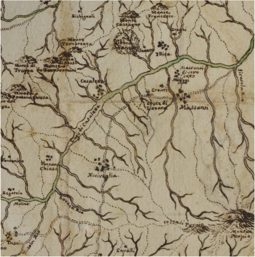
The landslide note in the RER landslides database (Regione Emilia-Romagna, Citation2019c) reports two events for this landslide, the most ancient around 1400 and a second one, more recent, in 2010. Even if not explicitly quoted, the historical source that reports the first landslide event is the study by Almagià (Citation1907, p. 86) which mentions an event generically dated to the fifteenth century but not (as will be seen in the Results and Discussions paragraph) the following event, mentioned by Boccia and Draghi, and dated 1725. Landslide evidences are reported in the two maps ascribed to Paolo Luigi Ippolito Gozzi (Parma 1713-Colorno 1783; Lasagni, Citation1999b; Masotti, Citation2006) (), probably realized after 1756, when the Duke of Parma gave him the task to map the boundaries of the duchy territory. Therefore, there are at least three textual sources and three maps containing relevant information that can be connected with the Casaleto-Illica landslide events occurrence ().
Table 1. Historical texts and maps sources collected for the Casaleto-Illica landslide.
3.1. Historical maps accuracy evaluation
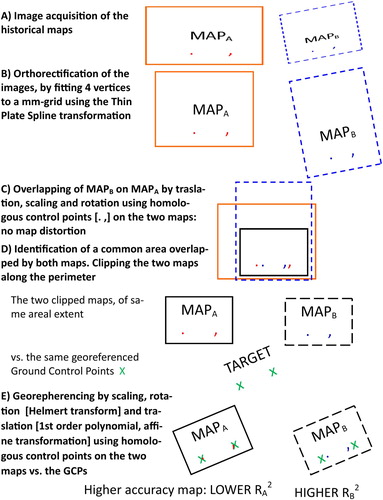
The map accuracy evaluation was performed on two historical maps by Paolo Gozzi coded in the Parma State Archives (ASPr), Raccolta di mappe e disegni, vol. 27/28 and 28/09: these maps extend for several square metres (see ). The process of cartographic accuracy evaluation was a useful preliminary step for selecting the best historical map to be georeferenced for the geo-historical synthesis map and followed different steps. It started with the acquisition of the images of the study area with a digital camera (Nikon D7000 with 18–105 mm lens) ((A)), since it was not possible to use a scanner with such large maps (). The image optical distortion was corrected by putting orthogonal rulers on the maps and then adapting 4 corners of the image to a mm-grid in the CitationQGIS (2020) software: the orthorectification of the images ((B)) was obtained by means of the Thin Plate Spline transformation. The two images obtained from the original maps (i.e. 27/28 and 28/09) were overlapped and scaled, and a common area, corresponding to the study area, was identified ((C,D)). The two clipped images were then georeferenced in QGIS environment using the same ground control points (GCPs) for both maps. Different transformation algorithms of rigid type (including only scaling, rotation and translation) were applied, finally comparing the accuracy of the two maps by means of the obtained values of mean squared error ((E)). Steps D and E were applied only for the process of map accuracy evaluation, whereas the orthorectified maps at step B were potentially ready for being georeferenced and included in the geo-historical synthesis map (we only included the historical map showing the higher accuracy). From a qualitative point of view, the overlay of the DTM and the historical maps locally shows a slight deviation of the two drainage networks, that can be likely attributed both to the handmade nature of the historical map and to the typical short-time dynamics of rivers that lead to continuous changes in their courses, making them poorly stable landscape features. However, we based the georeferencing on GCPs that possibly represent stable points in terms of spatial and temporal locations, as settlements (e.g. Illica, Casaleto, Ponteceno, etc.) and peaks of ridges (e.g. M. Castagno, M. Francesco, etc.).
Figure 2. Steps followed for establishing the historical map accuracy, by comparing two maps depicting the same area. The image distortion due to the camera or the scanner is eliminated by putting orthogonal rulers on the maps in step (A) and then applying an orthorectification of the image adapting them to a predisposed mm-sized grid in (B). The two maps are then overlapped considering the homologous points (symbols ‘.’ and ‘,’) and applying translation, scaling and rotation transformations (C). A common area identified on both maps is clipped (D) and then the two sub-maps are separately georeferenced using the same GCPs (E; symbol ‘X’) and applying rigid transformations only, finally obtaining the possibility to evaluate the accuracy of the two historical maps.
3.2. GIS-project and risk scenarios
A GIS-project was set up in order to analyse risk scenarios related to the landslide. A 3D rendering of the Ceno Valley, including the dammed lake formation, was obtained by integrating the historical description about the landslide event of 1725 and available geographic data from the RER geoportal, such as the AGEA 2011 orthophotos, the 5 m resolution Digital Terrain Model (DTM) of RER, and the landslide limits from the Landslide Inventory Map of the Historical Archive. This rendering allowed to update hazard and risk scenarios in the study area for the Ceno Valley in relation to the last high-magnitude landslide event that occurred in 1725.
3.2.1. Construction of the geo-historical synthesis map: source data and related software
The geo-historical synthesis map resulting from this study integrates in GIS environments (ArcMap, Citation2020; CitationQGIS, 2020) different types of data, acquired and managed following a multidisciplinary approach. The 5 m resolution DTM by RER (Regione Emilia-Romagna, Citation2019d) with a colour scale hillshade rendering has been employed as cartographic bases of the map. The DTM raster used covers an area of the Northern Apennines of ca. 200 sq.km, centred on a portion of the Ceno Valley extending N-S from Rocchenere to Mt. Segarino and W-E from Mt. Ragola to Mt. Pelpi (Main map, section ‘A’). A zoom-in of the study area, corresponding to the east-central portion of the clipped DTM, was also reported in the map (Main map, section ‘B’) including, in particular, the hamlets of Illica, Masanti di Sotto, Masanti di Sopra, Casaleto, Nociveglia, Fontanachiosa and Ponteceno. The georeferenced historical map by Gozzi coded 27/28, that had been selected after the process of accuracy evaluation, was then overlain to the DTM RER using a transparency of 35%, to allow a simultaneous view of both the DTM and the 27/28 map features. A clipping on the study area of the RER landslides database shapefile (Regione Emilia-Romagna, Citation2019e; Landslides inventory maps) has been added to the two layers mentioned above (i.e. DTM RER and 27/28 map), using different transparent filling patterns representing the different types of landslide deposits, in order to make possible a direct comparison among overlapping data and, in particular, to make easily appreciable the degree of overlap between modern (from the RER landslides database) and historical data. Finally, some geo-historical records have been reported in the right side of the map (Main map, boxes A.1, B.2), since they represent part of the original data from which the geo-historical synthesis map itself descends. In particular, the historical map by Gozzi coded 27/28 is shown (Main map, box B.3) together with a 3D reconstruction of the landslide-dammed lake (the ‘Casaleto lake’) obtained in QGIS environment by means of the analysis of the historical map compared with DTM RER (Main map, box B.3). One picture from Almagià (Citation1907, pp. 86–87) has been also included (Main map, box B.2), illustrating a detail of the deposits connected with landslides that affected the study of the area as discussed in this paper.
4. Results and Discussions
4.1. Historical document analysis
Almagià (Citation1907, p. 86) accounts for the instability affecting the slopes of the Ceno torrent Valley highlighting the high number of landslides, reported in the 1:500,000 scale map that accompanies the study (). He also describes the landslide that affected the Mt. Bello SW slope, near the small town of Illica: according to traditional oral sources an event that occurred in the fifteenth century destroyed a monastery of nuns, called the convent of Mezzane, and reached the Ceno torrent (). As a consequence, the landslide dammed the torrent and a temporary lake rapidly developed in that narrow portion of the valley (). As a careful reading of the text seems to confirm, since his study is based on the analysis of a questionnaire sent to local authorities and on land surveys, it is very unlikely that Almagià knew the reports of Draghi and Boccia previously mentioned.
Figure 3. Pictures of the map (1:500,000) by CitationAlmagià (Citation1907) documenting landslides (red irregular polygons in the map) affecting the study area.
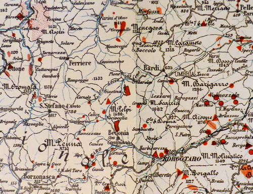
Figure 4. The Mt. Bello slope with the Illica landslide in AD 1907 (top picture, taken by R. Almagià) and in September 2020 (bottom picture, taken by G. Leonelli). Both pictures are taken from the right side of the Ceno Valley, in the vicinities of the Masanti di Sopra town, in the WNW direction.
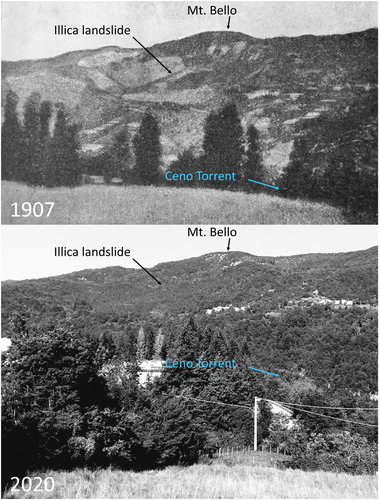
Figure 5. Detail of the landslide-dammed Lake of Casaleto reported in the Gozzi’s map 28/09 (the one not included in the geo-historical map): Topografico stato di Parma e di Piacenza; ASPr, Raccolta di mappe e disegni, vol. 28/09.
Boccia (Citation1989, p. 160) recalls the presence of a female convent, transferred to nearby Compiano during the rule of Maria Polissena Doria-Landi (1608–1679; erroneously referred by him as the wife of Agostino Landi, who died in 1555). This would postpone its destruction compared to what was written by Almagià. Boccia also reports in his text (written in 1804) of a landslide event that occurred on 12 November 1725 from the Poggio di Castagne, the SE slope of the Mt. Bello (‘Chestnuts Knoll’, toponym not reported on contemporary cartography, which reveals the likely presence of crop arrangements in the past). As Almagià, also Boccia (and after him, Draghi) reports that the landslide reached the bottom of the Ceno Valley, damming the torrent, but in his description, he reports more details that at his times probably were still living in the memory of the people. In fact, he indicates precisely that the water ran along the torrent reaching the baseof the ‘Mt. Vaccaro’ (now Mt. Vacca) (see for its location the Main map, box B.3, number 8), that the Author locates between Nociveglia and Tasola settlements (Main Map, section ‘A’). According to the Boccia’s manuscript, the lake persisted for eight days. It is possible, therefore, to consider more reliable the reconstruction made by Boccia instead of the one proposed by Almagià that seems more generic. It is very likely that the formation of the lake was therefore due to the landslide event of 1725 and not to that of the fifteenth century: in fact, the presence of the toponym Lago di Casaleto (‘Lake of Casaleto’) in Gozzi’s maps seems to confirm – as we will see – a link with the events described by Boccia. On the contrary, an important meaning must be recognized to the pictures (Main map, box B.2 and , top) that illustrate the manuscript of Almagià. These pictures, in fact, show different portions of the landslide and right through the photos the Author tries to illustrate even the relations between the landslide and the torrent.
Draghi (second half of the nineteenth century) () provides a reconstruction of the landslide events that is consistent with the one described by Boccia, both for the same sites cited and the referred circumstances. Draghi reports that the landslide event occurred in the day dedicated to St. Martin, 11 November 1725, and accounts that the Ceno torrent filled the valley bottom up to the site named Costa Lunga.
As noted, the landslide of Casaleto-Illica is reported in the two maps by Gozzi (). The cartographer indicates Mt. Castagno (in Boccia’s report Poggio di Castagne, ‘Chestnut Knoll’) as the source area of the landslide. Gozzi also draws the ‘Lake of Casaleto’, a toponym that is completely disappeared from the modern maps (as the lake is not present nowadays). Gozzi could have used this toponym to indicate the ‘reservoir’ formed as a consequence of the landslide, whose persistence would have been therefore much longer than the eight days indicated by Boccia.
A cadastral map of the study area dating back to the 1823 () also reports the toponym Rio delle Lubbie located between Le Lubbie and Casaleto di Illica sites. This small stream seems to interrupt a mule track and to feed a pond without any outflowing stream, with a resulting geomorphological setup that could be easily connected with the landslide occurrence.
4.2. GIS analysis
The two maps by Gozzi that have been selected for the accuracy assessment within QGIS environment resulted in different features. In particular, the map coded ASPr, Raccolta di mappe e disegni, vol. 27/28 results of higher accuracy, since after the georeferencing based on common GCPs it shows lower mean squared error (R2) values than the map coded 28/09 ().
Table 2. Mean squared error values obtained for the two overlapping maps’ areas (6.5 × 7 km) opportunely predisposed and georeferenced on the same GCPs using only rigid transformations including scaling, rotation (Helmert transformation) and translation (1st –order polynomial). Map coded 27/28 showed the lowest R2 values for both applied transformation algorithms, indicating a higher accuracy than the other map.
Based on the indications provided by Boccia on the lake extension, after the maps georeferencing we could detect its maximum altitude reached in the valley bottom, between Nociveglia and Tasola at the foot of the Mt. Vacca (formerly Mt. Vaccaro), that corresponds to approximately 710 m a.s.l., and we could also produce a 3D rendering of the lake extension (Main map, box B.3). The lake resulted to have been approximately 3.7 km long, covering an area whose northern limit was very close to the Masanti di Sotto site and southwards currently includes some buildings located close to the Ponteceno town. The presence of the landslide-dammed lake very close to Masanti di Sotto (approximately 0.6 km) was source of concern for the inhabitants, being the location of this town almost at the same altitude reached by the temporary lake.
The overlay of the DTM, the historical map and the RER landslide database (Main map, section ‘B’) highlighted, for the study area, a good spatial match between historical and modern data, especially with respect to the Casaleto-Illica landslide, that caused the lake formation (Main map, box B.3). According to the RER landslide database, the Casaleto-Illica landslide that affected the SE slope of Mt. Castagno, as documented in the historical map by Gozzi, corresponds to a large complex dormant landslide. Another similar landslide is reported in the RER database NE to the one of Casaleto-Illica, involving the Illica settlement itself. This landslide is located very close to the one of Casaleto-Illica, and it is not documented in the historical map by Gozzi, either because it occurred in much earlier or later times: in the first case, it was likely not noticed by the Author, in the latter case, more research is needed in order to retrieve historical data or field evidences of a more recent reactivation occurred after the map edition. The integration of historical and modern data is providing important information since it allows to confer a temporal connotation to database and archives that usually furnish data about the spatial distribution of landslide events just adding a relative time line (‘dormant’ or ‘active’ landslide), thus allowing to better define the event’s frequency of occurrence.
5. Conclusions
Based on the multidisciplinary approach here followed, i.e. extrapolating and interpreting the historical information and then actualizing it using a GIS-based approach, we propose a methodology for performing an integrated geo-historical study and constructing synthesis maps as tools for landslide hazard assessment at the local and sub-regional scales. In fact, we could demonstrate that the acquisition and analysis of the historical sources increased and enhanced the information about the space–time occurrence of the Casaleto-Illica landslide events: the landslide event of November 1725, in fact, has never been reported before in recent literature, and it is currently missing in the Historical Archive of Landslides of the Emilia-Romagna Region. In this archive only a large landslide event is reported dating to the fifteenth century (Almagià, Citation1907), but based on our analysis, we can now date the last large event to 1725, i.e. approximately 300 years closer to the present. Furthermore, if we date Gozzi’s maps to the mid-eighteenth century, we have to recognize that the permanence of the landslide-dammed lake is probably much longer than the eight days indicated by Boccia, so much to impose its mapping.
The detailed analysis of the historical texts has also provided precise information on the geographical extension of the landslide-dammed lake (the ‘Casaleto lake’) formed after the catastrophic event of 1725. By integrating this information in a GIS environment, we could spatially depict hazard scenarios for the current urban settlements.
In addition, based on a GIS approach, we could test the accuracy of the historical maps, providing a simple methodology that can be used in case of different maps depicting the same geographic area.
We can also generalize some conclusions:
according to recent scientific literature, the case study demonstrates how historical cartography, opportunely analysed, is a useful tool to better clarify the landslides dynamics and related hazards, especially in areas, such as the one investigated, where the evidences collected on the field are hindered by the growth of vegetation due to rural abandonment;
the study and cross-comparison between historical cartography, documentary and sedimentary sources and field evidences, can help to improve the accuracy of information contained in regional databases dedicated to landslides;
wealth and quality of records collected in the Italian archives can guarantee, in the future, new application opportunities. The study of historical cartography should be accompanied by investigations on memories and reports that in the past were drawn up by officials in charge of managing territory and on travel literature.
Map.pdf
Download PDF (66.9 MB)Acknowledgements
The Authors wish to thank Dr.ssa Valentina Bocchi, Archivio di Stato di Parma, for her support. The work was supported by the research fund CHELLI_2019_UNIO NEMONTANA Appennino Reggiano (Heads: A. Chelli). This work has besides benefited from the framework of the COMP-HUB Initiative, funded by the ‘Departments of Excellence’ program of the Italian Ministry for Education, University and Research (MIUR, 2018-2022).
Disclosure statement
No potential conflict of interest was reported by the author(s).
Additional information
Funding
References
- Almagià, R. (1907). Studi Geografici sulle frane in Italia. Volume I. Parte generale, L’Appennino Settentrionale e il Preappennino Tosco-Romano. Memorie della Società Geografica Italiana, 13, 1–344.
- Antolini, G., Pavan, V., Tomozeiu, R., & Marletto, V. (2017). Atlante climatico dell’Emilia Romagna 1961-2015. Arpae Emilia-Romagna Servizio IdroMeteoClima, 32.
- ArcMap. (2020). Esri software, version 10.6.1.
- Bailey, T. J., & Schick, J. B. M. (2009). Historical GIS: enabling the collision of History and Geography. Social Science Computer Review, 27(3), 291–296. https://doi.org/10.1177/0894439308329757
- Belardi, A., & Zanichelli, G. (2011). Attività di base per l’utilizzo della cartografia storica a grande scala in ambito geomorfologico e idraulico: Il caso dell’ambito golenale medio cremonese. In L. Masotti (Ed.), Il paesaggio dei tecnici. Attualità della cartografia storica per il governo delle acque (pp. 111–120). Venezia, Italy.
- Bennett, R. A., Serpelloni, E., Hreinsdóttir, S., Brandon, M. T., Buble, G., Basic, T., Casale, G., Cavaliere, A., Anzidei, M., Marjonovic, M., Minelli, G., Molli, G., & Montanari, A. (2012). Syn-convergent extension observed using the RETREAT GPS network, northern Apennines, Italy. J. Geophys. Res, 117, B04408. https://doi.org/10.1029/2011JB008744
- Biszak, E., Kulovits, H., Biszak, S., Timár, G., Molnár, G., Székely, B., Jankó, A., & Kenyeres, I. (2014). Cartographic heritage of the Habsburg Empire on the web: the MAPIRE initiative. 9th International Workshop on Digital Approaches to Cartographic Heritage, Budapest, 4-5 September 2014. https://mapire.eu/en/
- Boccia, A. (1989). Viaggio ai Monti di Parma. Ed. Palatina, Parma, Italy.
- Bonardi, L., & Mastrovito, D. (2020). I catasti storici come strumento di prevenzione del rischio ambientale. Il catasto lombardo-veneto e la sua applicazione nell’area lariana. In A. Gallia (Ed.), Territorio: Rischio/risorsa. Dalla mappa al GIS. Collana del Laboratorio geocartografico ‘Giuseppe Caraci’, 6 (pp. 73–92). Labgeo Caraci.
- Carallo, S. (2020). Le fonti geostoriche per la prevenzione del rischio idrogeologico. Il territorio pontino, progettualità passate e presenti. In A. Gallia (Ed.), Territorio: Rischio/risorsa. Dalla mappa al GIS. Collana del Laboratorio geocartografico ‘Giuseppe Caraci’, 6 (pp. 243–268). Labgeo Caraci.
- CartoMundi. (2019). Valorisation en ligne du patrimoine cartographique; http://www.cartomundi.fr/site/
- Cassi, L. (2009). Frane e nomi di luogo, un esempio di applicazione GIS. In A. Favretto & M. Azzari (Eds.), Atti del convegno VII workshop Beni ambientali e culturali e GIS. Comunicare l’ambiente, Trieste 21 November 2008 (pp. 71–79). Patron Editore.
- Cencetti, C., De Rosa, P., & Fredduzzi, A. (2020). Characterization of landslide dams in a sector of the central-northern Apennines (Central Italy). Heliyon, 6(6), e03799. https://doi.org/10.1016/j.heliyon.2020.e03799
- Cevasco, A., & Cevasco, R. (2013) ‘Montagne che libbiano’ e zone umide colmate? Il ‘lago’ di Torrio (Val d’Aveto, Ferriere, Pc). In R. Cevasco (Ed.), La Natura della Montagna. Scritti in ricordo di Giuseppina Poggi (pp. 444–452). Oltre Edizioni, Sestri Levante (Genoa).
- Cevasco, A., Ivaldo, E., & Scarpati, A. (2009). L’importanza della cartografia storica nello studio della dinamica dei versanti: Il caso della frana in località ‘La Liggia’ (Alassio, Liguria occidentale). PG Professione Geologo, 2, 6–19.
- Diodato, N., Soriano, M., Bellocchi, G., Fiorillo, B., Cevasco, A., Revellino, P., & Guadagno, F. M. (2017). Historical evolution of slope instability in the Calore River Basin, Southern Italy. Geomorphology, 282, 74–84. https://doi.org/10.1016/j.geomorph.2017.01.010
- Elter, P., Lasagna, S., Marroni, M., Pandolfi, L., Vescovi, P., & Zanzucchi, G. (2005). Note illustrative della Carta Geologica d’Italia alla scala 1:50.000, foglio 215 Bedonia. Regione Emilia Romagna, SELCA, Florence.
- Faccini, F., Paliaga, G., Piana, P., Sacchini, A., & Watkins, C. (2016). The Bisagno stream catchment (Genoa, Italy) and its major floods: Geomorphic and land use variations in the last three centuries. Geomorphology, 273, 14–27. https://doi.org/10.1016/j.geomorph.2016.07.037
- Giardino, M., Mortara, G., Borgatti, L., Nesci, O., Guerra, C., & Lucente, C. A. (2015). Dynamic geomorphology and historical iconography. Contributions to the knowledge of environmental changes and slope instabilities in the Apennines and the Alps. In G. Lollino, D. Giordan, C. Marunteanu, B. Christaras, Y. Iwasaky, & C. Margottini (Eds.), Engineering geology for society and territory (Vol. 8, pp. 463–468). Springer.
- Grava, M., Berti, C., Gabellieri, N., & Gallia, A. (2020). Historical GIS. Strumenti digitali per la geografia storica in italia. Associazione Italiana di Cartografia, Edizioni Università di Trieste.
- Gregory, I., & Healey, R. G. (2007). Historical GIS: Structuring, mapping and analysing geographies of the past. Progress in Human Geography, 31(5), 638–653. https://doi.org/10.1177/0309132507081495
- Harley, J. B. (2001). The New Nature of Maps essays in historical cartography. Johns Hopkins.
- Lasagni, R. (1999a). Boccia, Antonio. Dizionario Biografico dei Parmigiani. Parma, PPS ed. vol. I. http://www.parmaelasuastoria.it/it-IT/Dizionario-biografico–Boarini-Boqui.aspx
- Lasagni, R. (1999b). Gozzi, Paolo Luigi Ippolito. Dizionario Biografico dei Parmigiani, Parma, PPS ed., 1999, vol. II. http://www.parmaelasuastoria.it/it-IT/Dizionario-biografico–Giorgi-Gozzini.aspx#gozzi%20paolo
- Lazzari, M. (2014). Utilizzo delle fonti storiche per lo studio della pericolosità e del rischio geomorfologico. Memorie descrittive della Carta Geologica d'Italia, 96, 251–260.
- Luino, F., Belloni, A., Turconi, L., Faccini, F., Mantovani, A., Fassi, P., Marincioni, F., & Caldiroli, G. (2018). A historical geomorphological approach to flood hazard management along the shore of an alpine lake (Northern Italy). Natural Hazards, 94(1), 471–488. https://doi.org/10.1007/s11069-018-3398-5
- Masotti, L. (2006). Gozzi, Paolo Luigi Ippolito. In M. Petrella, C. Santini, & S. Torresani (Eds.), Geo-grafie di un territorio. Studi e ricerche per un dizionario storico dei cartografi in Emilia-Romagna. Patron Edizioni.
- Masotti, L. (2017). Raffigurare lo spazio, governare il territorio. Percorsi di ricerca geostorica per la mitigazione del rischio ambientale. Patron Edizioni.
- Molli, G. (2008). - Northern Apennine–Corsica orogenic system: An updated overview. In S. Siegesmund, B. Fugenschuh, & N. Froitzheim (Eds.), Tectonic Aspects of the Alpine–Dinaride–Carpathian System, Geological Society of London Special Publications (Vol. 298, pp. 413–442). Geological Society of London.
- Murakami, S., Tien, T. L., Omar, R. B. C., Nishigaya, T., Aziza, N., Roslan, R., Baharuddin, I. N. Z., Lateh, H. H., & Sakai, N. (2014). Landslides Hazard Map in Malay Peninsula by using historical landslide database and related information. Journal of Civil Engineering Research, 4(3A), 54–58. https://doi.org/10.5923/c.jce.201402.08
- OldMapsOnline. (2019). http://www.oldmapsonline.org/
- Paliaga, G., Faccini, F., Luino, F., Turconi, L., & Bobrowsky, P. (2019). Geomorphic processes and risk related to a large landslide dam in a highly urbanized Mediterranean catchment (Genova. Italy). Geomorphology, 327, 48–61. https://doi.org/10.1016/j.geomorph.2018.10.020
- Piana, P., Faccini, F., Luino, F., Paliaga, G., Sacchini, A., & Watkins, C. (2019). Geomorphological landscape research and flood management in a heavily modified Tyrrhenian Catchment. Sustainability, 11(17), 4594. https://doi.org/10.3390/su11174594
- Piastra, S. (2015). La dimensione culturale di un fenomeno di dissesto. Nuovi dati sulla frana di Boesimo di Brisighella (1690). Studi Romagnoli, LXVI, 729–740.
- Poli, D. (2001). Rappresentazione delle identità storico-morfologiche dei luoghi. In A. Magnaghi (Ed.), Rappresentare i luoghi. Metodi e tecniche (pp. 215–285). Alinea, Firenze.
- QGIS Development Team. (2020). QGIS Geographic Information System. Open Source Geospatial Foundation Project, version 3.4.3. http://qgis.osgeo.org
- Regione Emilia-Romagna. (2019a). Landslides Historical Archive: https://ambiente.regione.emilia-romagna.it/it/geologia/temi/dissesto-idrogeologico/larchivio-storico-dei-movimenti-franosi
- Regione Emilia-Romagna. (2019b). Landslide Inventory Map and Landslides Historical Archive: https://ambiente.regione.emilia-romagna.it/it/geologia/cartografia/webgis-banchedati/cartografia-dissesto-idrogeologico
- Regione Emilia-Romagna. (2019c). Historical Archive of Landslides: landslide ‘Lubbie (fianco M. Bello) SC Casaleto – Illica’: http://geo.regione.emilia-romagna.it/schede/fs/fs_dis.jsp?id=121491
- Regione Emilia-Romagna. (2019d). Geographic Data Catalog: https://geo.regione.emilia-romagna.it/geocatalogo/
- Regione Emilia-Romagna. (2019e). Landslide Inventory Map and Landslides Historical Archive, SHP data: https://ambiente.regione.emilia-romagna.it/it/geologia/cartografia/webgis-banchedati/cartografia-dissesto-idrogeologico#consulta-dati-shp
- Regione Liguria. (2019). Historical Cartographic Archive: https://geoportal.regione.liguria.it/servizi/archivio-storico.html
- Rossi, L. (2018). Ancora sulla rappresentazione del rilievo. La centralità francese e un precoce caso italiano (sec. XIX). Geotema, 58(XXII), 70–79.
- Rumsey, D. (2019). David Rumsey Map Collection; https://www.davidrumsey.com/
- Segadelli, S., Grazzini, F., Adorni, M., De Nardo, M. T., Fornasiero, A., Chelli, A., & Cantonati, M. (2020). Predicting extreme-precipitation effects on the geomorphology of small mountain catchments: Towards an improved understanding of the consequences for freshwater biodiversity and ecosystems. Water, 12(1), 79. https://doi.org/10.3390/w12010079
- Seminario Bedonia. (2019). http://www.seminariobedonia.it/parrocchie-val-ceno/illica/
- Tacconi Stefanelli, C., Segoni, S., Casagli, N., & Catani, F. (2016). Geomorphic indexing of landslide dams evolution. Engineering Geology, 208, 1–10. https://doi.org/10.1016/j.enggeo.2016.04.024
- Tosatti, G., Castaldini, D., Barbieri, M., D’Amato Avanzi, G., Giannecchini, R., Mandrone, G., Pellegrini, M., Perego, S., Puccinelli, A., Romeo, R. W., & Tellini, C. (2008). Additional causes of seismically-related landslides in the Northern Apennines, Italy. Rev. Geomorfol, 10, 5–21.
- Valbona, F., & Gabellieri, N. (2016). Eventi calamitosi e GIS: Proposta per un approccio storico applicato alla toponomastica toscana. In A. D’Ascenzo (Ed.), Terremoti e altri eventi calamitosi nei processi di territorializzazione (pp. 269–287). Labgeo Caraci.
- Withers, C. W. J. (2009). Place and the ‘Spatial Turn’ in Geography and in History. Journal of the History of Ideas, 70(4), 637–658. https://doi.org/10.1353/jhi.0.0054
- Zanichelli, G. (2011). La forza delle piene, l’opera dell’uomo. Evoluzione idromorfologica di un territorio conteso attraverso due secoli di rappresentazione cartografica. In L. Masotti (Ed.), Il paesaggio dei tecnici. Attualità della cartografia storica per il governo delle acque (pp. 129–157). Marsilio.