
ABSTRACT
Identification of the remnant traces of paleo-glaciers provides important proxies to understand the response of the environment to rapid climate changes. We present a 1:25,000 scale geomorphological map covering ∼12.5 km2 of the upper part of Mount Bistra (North Macedonia) on the basis of remote sensing analyses and geomorphological surveys. Particular attention is given to the description of glacial and periglacial landforms, to the reconstruction of single glacier shapes and to Equilibrium Line Altitude (ELA) value calculation. The results of the survey and the reconstructed ELAs indicate the occurrence of three glacial phases that led to the formation of frontal and lateral moraines. The age of these phases is tentatively attributed to the Late Pleistocene by comparing these ELAs with those of other Balkan mountains. This map is the first step of a wider project aimed at reconstructing the relation between climate change and geomorphic response in this area.
1. Introduction
Small glaciers at mid-latitudes, like those developed in the Mediterranean mountains, are very sensitive to climate changes and their responses to environmental variations are very rapid and can be recorded. This sensitivity makes it possible to analyse paleo-glacier oscillations to study paleoclimate, and also to foresee the consequences of modern climate changes (CitationHaeberli & Beniston, 1998; CitationHuss & Fischer, 2016; CitationOerlemans, 2001).
Several glacial phases occurred during the Quaternary in the Mediterranean mountains (Hughes, Citation2011; Hughes & Woodward, Citation2017. and references therein), as evidenced by many glacial landforms and deposits. Many authors have investigated the amplitude and timing of Quaternary glacial phases in Mediterranean mountains (e.g. CitationBaroni et al., 2018; CitationFederici et al., 2008, Citation2012, Citation2017; CitationFinsinger & Ribolini, 2001; CitationGiraudi, 2012; CitationGiraudi et al., 2011; CitationHughes et al., 2006a; CitationHughes & Woodward, 2008, Citation2017; CitationIsola et al., 2019; CitationMesserli, 1967; CitationSpagnolo & Ribolini, 2019).
The first records of Pleistocene glaciation in the Balkan Peninsula come from Cvijić, who identified many glacial forms when he explored the Šara Mountain (Ljuboten, 2499 m a.s.l.), in 1891 (CitationCvijić, 1917). Various authors later reported on glacial remains throughout the Balkans, but only recently has it been possible to establish the phases of glacial advance and retreat, thanks to some chronological constraints (e.g. CitationGromig et al., 2018; CitationHughes, 2007; CitationHughes et al., 2006a; Citation2011; CitationKuhlemann et al., 2009; CitationRibolini et al., 2018; CitationRuszkiczay-Rüdiger et al., 2020; CitationTemovski et al., 2018; CitationŽebre et al., 2019). CitationLeontaritis et al. (2020) reviewed the glacial history of the mountain of Greece and proposed some chronological correlations with glacial phases described for the surrounding regions. As concerns Balkan glaciations, after the work of CitationKolčakovski (1999), the mountains of North Macedonia have only recently been studied in more detail, (CitationGromig et al., 2018; CitationRibolini et al., 2018; CitationRuszkiczay-Rüdiger et al., 2020; CitationTemovski et al., 2018; CitationŽebre et al., 2019). The results obtained so far have shown that in addition to the phases of the Last Glacial Maximum (LGM), or to antecedent cold events, there were glacial readvances/standstills even during the late Pleistocene deglaciation.
On the basis of this approach, we present a geomorphological map of the topmost part of the Bistra Mountain, located in northern Macedonia. Particular attention is focussed on glacial features (e.g. moraines, cirques) and on the reconstruction of the shape of paleoglaciers for the calculation of Equilibrium Line Altitudes (ELAs). These values are then used to build a possible sequence of glacial phases in the studied area and to compare these cold events with others described in the Balkan region.
2. Study area
The Bistra massif, situated in the western part of North Macedonia (), belongs to the Šara-Pelister mountain range. The massif has several peaks of over 2000 m a.s.l. and reaches the highest elevation at Medenica (2163 m a.s.l). The alignment direction of the highest mountain ridges is NNW-SSE, which reflects the general Dinaric direction (Milevski, Citation2016). Mean annual temperature in the study area is in the temporal interval 1960–1990, ∼4.4°C, while mean annual precipitation in the same interval approximates ∼1030 mm/yr (Milevski, Citation2015).
The Bistra Mountain corresponds to a syncline horst block bordered by faults belonging to the Western Macedonian Tectonic Unit, which extends from the Šara Mountains (Šar Planina) in the north to the Pelister Mountains in the south. This Unit geologically belongs to the Dinarides (Helenides) (CitationArsovski, 1960), and it is principally composed by a Paleozoic metamorphic complex, with volcanic and sedimentary formations in the lower parts, and a carbonate formation in the upper parts. Basal Paleozoic schists and marbles, which outcrop only locally, are covered by Triassic limestones with a thickness of 400 m. Marble and limestone outcrops, locally fractured, together with abundant precipitations, have favoured intense karst processes, so that the area of the Bistra Mountain appears as an extensive karst denudation surface, punctuated by a number of topographic peaks. The area presents several caves and sinkholes, as well as surface karst landforms (karren, dolinas, karst valleys, poljes) (CitationAndonovski, 1977).
Alongside the karst features dominating the landscape, the glacial landforms are relevant elements of the landscape. This is because Pleistocene glaciers affected the Bistra Mountain, leaving deposits and erosional traces like the glacial cirques carved in the Medenica and Čaušica peaks (CitationManakovikj & Andonovski, 1983). However, these glacial landforms, especially the depositional landforms, have received little attention, despite their well-developed appearance. Since 1949, this area has been a National Park, and nowadays covers an area of ∼734 km2. Dense forest vegetation covers the mountain slopes in the lower part of the park, while Alpine grassland grows in the highest areas. The Park is characterized by very high biodiversity and by the presence of numerous relict and endemic species (both herbaceous plants and trees), mostly related to the last glaciation. The presence of the artificial lake Mavrovo, which is one of the largest lakes in North Macedonia (∼13.7 km2), and of one of the major ski resorts in the uppermost parts of the area, have favoured its touristic development.
3. Methods
The geomorphological map of the topmost part of Bistra Mountain (Main Map) was drawn on the basis of the criteria adopted by CitationRibolini et al. (2011) and CitationIsola et al. (2011, Citation2017). After collecting the bibliographic data, we made a preliminary analysis of the area by using remote sensing tools to identify the most important geomorphological features. Quickbird imageries (QB02 sensor and Pan_MS1 band, 60 cm spatial resolution, year 2008) were used for this analysis. Three field campaigns were then performed to gather detailed geomorphological data. Owing to the lack of a high-resolution topographic map, field observations were drawn directly onto Quickbird imageries, and many GPS ground control points were acquired in correspondence to the most relevant geomorphological features. This phase of geomorphological map building is fundamental because some landforms cannot be identified clearly from the satellite imageries on account of their resolution, tone and texture.
All the data were then uploaded in a GIS environment so as to generate a geodatabase with both raster and vector levels. The raster levels consist of the Quickbird imageries and the reinterpolated high-quality 5-m digital elevation model (DEM) from the Agency of the Real Estate Cadastre (AREC) of North Macedonia (CitationMilevski, 2014), used as a base for the final map. The vector levels (points, lines and polygons), manually redrawn in GIS from the original field-work maps, correspond to the geomorphological features identified. The contour lines (25 m equidistance) used for the final map are derived from the DEM. Toponyms and elevation points come from Lazarpole (CitationRepublička geodetska uprava Skopje, 1972) and from the Mavrovo (CitationRepublička geodetska uprava Skopje, 1978) topographic maps at 1:25,000 scale.
4. Results
The geomorphological map covers ∼12.5 km2, and consists of ∼900 polygonal features and ∼100 linear features, in large part taking into account the criteria reported in CitationGLCM (1994). These criteria consist in assigning a single colour to landforms belonging to the same morphogenetic domain, and different shades of the same colour to distinguish active from inactive landforms.
A shadow-relief representation of the topography (resolution 10 m, sun azimuth 315°, sun high 45°) was used to better appreciate surface roughness.
Glacial, periglacial (mainly fossil) and karst are the most widespread landforms and deposits, strongly characterizing the Bistra landscape at various elevations ( and ). The map is limited to the topmost part of the Bistra Mountain, with a focus on the glacial and periglacial landforms that are the main targets of this paper. However, the survey was extended outside the map limits to check the presence of other glacial deposits and to assess the landscape at a more regional scale. Given the aim of the paper, particular attention is devoted to the description of glacial and periglacial landforms, while those of other origin are only synthesized for the sake of completeness.
Figure 1. Location of the sites mentioned in the text.
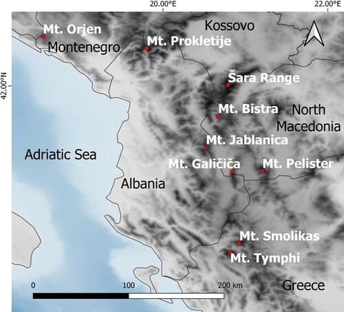
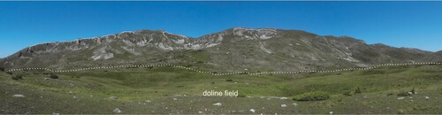
Figure 2. Landscape of the eastern side of Mt. Bistra. Glacial cirques (solid white lines in the background) and the doline field developed in the glacial deposits (limit marked by the dashed white line in the foreground) are visible.
4.1. Glacial landforms and deposits
Five types of glacial landforms (cirques, glacial steps, moraine ridges, glacial deposits and cemented glacial deposits) have been identified. For their representation, purple has been used to combine linear symbols with polygons. Six glacial cirques at the border of a general smooth summit relief are formed, with variable aspects from northeast to northwest. The crest ridge of five of the cirques: Ezerište, Čaušica, Bistra III, Bistra II and Bistra I (following the terminology of CitationVasilevski, 2011), developed between ∼1950 and 2000m a.s.l., while Medenica is located at ∼2100 m a.s.l. The coalescence of several cirques in the same sub-basin explains the irregularity of the cirque crest-line. Most cirques present vertical backwalls and lateral sides, whilst central over-deepened depressions and valley steps are hardly visible, since they are buried by detrital deposits of different origins. Evidence of ongoing toppling rockslides was observed in the rock wall of the Bistra I1 cirque.
Although partly covered by glacial debris and incised by torrents, the only one valley step presumably shaped by glacial erosion is placed at the base of the valley descending from the Čaušica cirques. As a result, the uppermost part of the relief forms a hanging valley above the fluvial plain.
Glacial deposits cover ∼2.6 km2 in the entire mapped area, and mainly consist of poorly sorted debris with grain sizes varying from cobbles to boulders. The deposit is a clast-supported massive diamicton with a limited sandy-gravel matrix in pockets. These deposits cover the over-deepened cirque depressions down the slopes toward the valley. A glacial deposit infills the valley depression at the base of the slope descending from several cirques. The thickness of this deposit is in the 2–8 m range, and the bedrock crops out locally. Lateral and frontal moraines are evident in each sub-basin analysed. The frontal moraines exhibit both regular arcs and sinuous-shaped ridges, whereas lateral moraines consist of single ridges elongated for several hundreds of metres. Most frontal moraines are composed of single arcs/ridges, and nested frontal moraines are rarely observed. In some cases, large boulders (up to 2 m in diameter) stand on moraine ridges or on the surface of sparse glacial deposits interpreted as erratics (not represented in the map). The most relevant glacial deposits in the mapped area are described here.
The glacial deposits related to the Ezerište cirque cover ∼0.63 km2 with several lateral and frontal moraines. The lower moraine, located at ∼1720 m a.s.l., is formed by a glacial tongue flowing northward in the narrow valley between the Planinica and Golem Rid crests. The northern and western sides of the deposit are bounded by a long and almost continuous lateral moraine. Several moraine arcs in the southern and eastern sides mark the occurrence of retreat and/or of stillstand phases of a small cirque glacier flowing eastward from Ezerište. A number of nested moraines were mapped between 1835 and 1845 m a.s.l. in the Lekočere area.
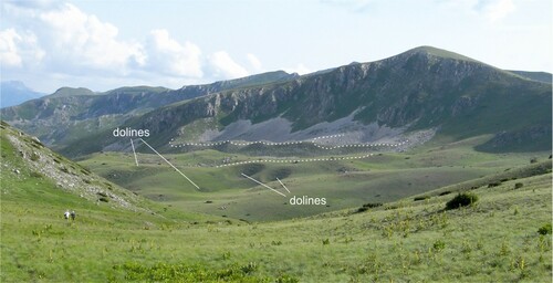
Glacial deposits from the Čaušica cirque cover a total of ∼0.36 km2. The lowest part of this deposit is sinuously shaped according to four lobes whose corresponding fronts are respectively at 1775, 1760, 1760 and 1730 m a.s.l. from north to south. Inner frontal moraines are present at 1800, 1830, 1840, 1850 m a.s.l ().
Figure 3. Čaušica glacial cirques (northeastern side of Mt. Bistra). Dolines are evident in the glacial deposit. Dashed lines mark the main moraine ridges.
Glacial deposits at Bistra IV cover only 0.05 km2. Here, two frontal moraine ridges bordering the cirque area are present at 1840 and 1860 m a.s.l. On the northernmost side there is the lowest frontal moraine ridge of the study area at 1690 m a.s.l.
Glacial deposits in the Manastirište area extend for 0.8 km2, draping a north–south oriented doline field, partially filling the depressions and giving rise to a highly irregular surface morphology. These deposits extend upvalley to partly infill the Bistra II cirque, but were probably related also to the Bistra I and III cirques at the time of their formation. Frontal moraine ridges are present at 1760, 1780, 1810, 1860 m a.s.l.
The deposits in the Bistra I cirque cover 0.06 km2 and two frontal moraine ridges are present at 1780 and 1700 m a.s.l.
The southernmost glacial deposits of the area westward of Medenica cover 0.3 km2 from 2100 to 1680 m a.s.l. The lowest frontal moraine ridge is at 1790 m, while the highest ridges are at 1950, 1970 and 1990 m a.s.l.
Glacial deposits on the western sector of the Bistra mountain spread for 0.1 km2 in the Trebiška Rupa area up to 1890 m a.s.l. Five frontal moraine ridges are present between 1900 and 1930 m a.s.l.
In the Juročka Češma area the glacial deposits discontinuously cover ∼0.5 km2 with the lowest frontal moraine at 1875 m a.s.l. and the highest at ∼1930 m a.s.l.
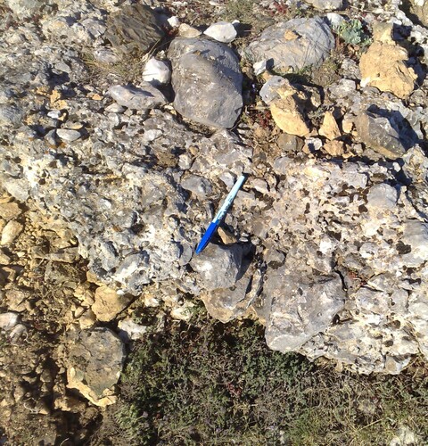
A very small outcrop of cemented deposits () of glacial origin is located only at ∼1875 m north of Gorna Korija. It is composed of sub-rounded clasts within carbonate cement.
Figure 4. Cemented deposits of glacial origin located north of Gorna Korija.
4.2. Periglacial and nival deposits
Two types of periglacial and nival landforms (rock glaciers and pronival ramparts) have been identified. For their representation, linear symbols with polygons have been combined using the pink colour for rock glaciers and the blue colour for pronival ramparts. Both the rock glaciers and the pronival ramparts extend for ∼0.26 km2.
A first group of rock glaciers, those in the Gorna Korija area, is formed by three coalescent landforms extending between 1820 and 1760 m a.s.l.. In the Manastirište area, two distinct groups of rock glaciers were mapped, the former consisting of three small rock glaciers whose frontal elevations are between ∼1816 and 1810 m a.s.l.; the latter consists of three landforms whose frontal elevations are between ∼1776 and 1791 m a.s.l.. The longest mapped rock glacier is located in the Medenica area, where a tongue-shaped form extends for 950 m from a front at ∼1900 m a.s.l..
The rock glaciers present tongue-shaped forms, and only in some cases have spatulate (sensu CitationHumlum, 1982) geometry. Interestingly, the majority of rock glaciers have their rooting zone inside glacial accumulation and terminate on the inner side of frontal moraines. Furthermore, a large and multilobate rock glacier in the area of the Medenica cirque shows stratigraphic overlapping onto a glacial deposit. Here, the south-east verging ridges cut a right latero-frontal moraine along the south-west directed lobe.
Only one pronival rampart was mapped in the Manastirište area at the foot of a north-facing slope at ∼1780 m a.s.l. Alongside its sedimentological characteristics, the distal/proximal slope dip of the ramp and its development in plan form was taken into account to distinguish this feature from an embryonic single-ridge rock glacier (CitationHedding, 2016). In the case of the mapped landform, the distal slope of the ramp is less inclined than the proximal one, and the crest exhibits a single and slightly curved shape, while the deposit presents an open-work fabric (essentially composed of angular clasts and very low amounts of fines). Despite their non-univocal diagnostic characteristics (CitationHedding, 2016, and references therein), these observations can be considered reliable indicators of debris accumulation at the base of a long-lasting snow cover.
4.3. Other mountain landforms
Six alluvial types of landforms (colluvial–alluvial deposits, alluvial fans, debris flow fans, marsh deposits, gullies and surfaces affected by rill erosion) have been identified. Lines and polygons in different shades of green have been used for their representation. The areas at the base of the mountain slopes are covered with extensive alluvial deposits transported by seasonal or ephemeral creeks. These are flat or slightly inclined surfaces, locally exhibiting sinkholes and traces of channelization. Fan-shaped alluvial accumulations have formed locally where temporary stream transport reaches the slope base. The mapped alluvial fans consist of both single and coalescent landforms. In general, sandy-gravel with rare decametric clasts is of the dominant alluvial type.
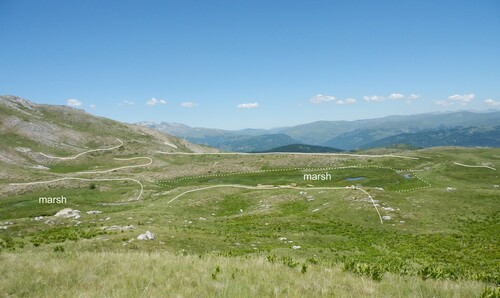
The presence of several moraine ridges at the bottom of the valley favoured the formation of marshes via damming of surface waters. Marsh development was preceded by the existence of a lake that eventually underwent progressive silting. The mapped marshes are mainly concentrated in the Lekočere area () and in the northernmost part of the study area, and are located from north to south at 1810, 1845, and 1835 m a.s.l. A small marsh at Bistra III is currently located between two moraine arcs at 1850 m a.s.l.
Figure 5. Marshes in the Lekočere area (dashed line) dammed by moraine ridges (solid line).
Three gravitational types of landforms (rockfalls, debris cones, scree slopes) have been identified at the foot of steep slopes and rock walls of the glacial cirques. Red-coloured polygons for active forms and orange-coloured polygons for inactive forms have been used for their interpretation.
In the Bistra Mountain, the majority of outcropping lithotypes (marbles, dolomitic marbles and limestones) have a carbonate composition. The combination of these rock types and abundant precipitations have favoured karst dissolution, shaping the relief at various scales. It is possible to recognize a karst plateau in the long wave-length of the relief. Micro-scale solution features (e.g. karrens) are not frequent and meso-scale landforms such as sinkholes, dolines and small blind-valleys are barely visible since they are almost totally covered by glacial till and alluvial–colluvial deposits. Yellow-coloured polygons have been used for their representation.
4.4. Ice-surface reconstruction and ELA calculation
The survey of glacial landforms made it possible to reconstruct the glacier geometry () derived either by interpolation and extrapolation of mapped glacial landforms (e.g. moraines, lateral steps in valley flanks, overall valley topography), or by inferred paleoglacial limits (i.e. freehand drawing of glacier margins) (see guidelines in CitationPorter, 1975). The calculation of the ELA of reconstructed glaciers is a classic method used to retrieve the relative chronology of different glacial advances/retreats in the same area and across the surrounding regions. This is because glaciers respond to changes in air temperature and precipitation by adjusting their mass balance, and thereby shifting their ELA. It is assumed that similar ELAs ultimately correspond to the same climatic phase (CitationBakke & Nesje, 2011; Oerlemans, Citation2005, and references therein).
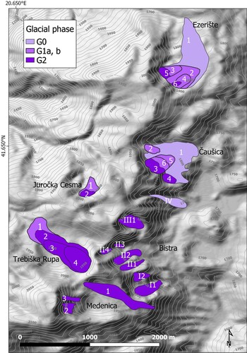
Figure 6. Reconstruction of paleo-glacier shapes and attribution of glacial phases
We adopted the ELA calculation toolbox (CitationPellitero et al., 2015) to automatically derive the ELA value of the reconstructed glaciers, by applying the classic area-altitude balance ratio (AABR) method (CitationOsmaston, 2005). A ratio value of 1.6 was used, which corresponds to the average obtained for existing glaciers in other Mediterranean mountains (CitationRea, 2009; CitationRea et al., 2020).
In the northern sector of the Ezerište area, following a phase that formed a well-developed glacier (∼1500 m long), deglaciation is punctuated by some readvances/standstills marked by frontal moraines. More specifically, an older phase with an ELA of 1813 m a.s.l. can be recognized, followed by two phases with very similar ELAs (1846 m, 1847 m and 1850 m a.s.l. respectively). It is worth noting that the moraines in the area of the Ezerište marsh – grouped in a single phase – are very close to each other, and locally appear as nested moraines. Nested frontal moraines are also present in the Čaušica area where the ELA values are 1807 m, 1848–1855 m and 1863 m a.s.l.
In the area of Trebiška Rupa, four frontal moraines can be recognized along with a valley sector that is ∼1200 m long and NW oriented. The ELA values from the older to the younger moraines vary from 1916 to 1935 m a.s.l.. The results of this analysis are shown in .
Table 1. ELA values calculated following CitationPellitero et al. (2015), and applying the AABR method with ratio value of 1.6.
5. Discussion
The geomorphological map of the Bistra Mountain is the first step of a wider project aimed at reconstructing the relationship between climate change and geomorphic response in this area. The results of this study can be compared with other data from the mountains of North Macedonia (i.e. the Jablanica, Pelister and Galičiča mountains) and other sectors of the Balkans.
Starting from the mapped frontal and lateral moraines, the paleoshape of the single glaciers was reconstructed (), and the calculated ELAs () can be grouped according to three possible glacial oscillations: ca. 1750–1800 m a.s.l. (G0 phase), ca. 1850–1900 m a.s.l. (G1), and 1800–2010 m a.s.l. (G2). In the Ezerište and Čaušica areas, the G1 phase is characterized by nested moraines very close to each other, which can be interpreted as two pulses of the same glacial phase (G1a and G1b in and ). The G2 phase appears to have formed glaciers in almost all the areas examined, and it is evident that most of the glaciers were confined inside the cirques (not overcoming the threshold) or consisted of a small ice remnant at the base of the rockwall (e.g. Čaušica).
Four frontal moraines in the area of Trebiška Rupa can be recognized along a valley sector ∼1200 m long and NW oriented. The ELA values from the older to the younger moraines vary from 1916 m to 1935 m a.s.l.. This suggests that after the oldest phase, tentatively assigned to G1, the valley deglaciation was probably characterized by standstill phases leading to the formation of recessional moraines that were very close to each other.
The geomorphological survey evidenced that after the G2 glacial phase a non-glacial cold period affected the area. In some sub-basins (Medenica I, Bistra II and Čaušica) this led to the formation of permafrost inside glacial accumulations or scree deposits eventually forming rock glaciers instead of small glaciers Rock glaciers most likely co-existed with the small cirque glaciers at ∼2000 m a.s.l. in the upper part of Medenica. This phenomenon suggests a cold phase characterized by dryer conditions, with summer precipitations lower than those at the limit for the presence of glaciers (CitationOhmura et al., 1992). Persistent snow accumulation only took place at higher elevations, while most debris accumulations in other sectors of the slopes were exposed to atmospheric cooling. These conditions (cold air temperature and limited rainfall) are the most favourable for permafrost formation (CitationFrench, 2017).
Grouping of the reconstructed ELAs was challenging because elevation distribution is in some cases inconsistent with a clear sequence of glacial phases across the valleys examined. This probably depends on the topography and on the small size of the former glaciers, that is, mainly small and steep cirque glaciers with very short or no tongue. Owing to these characteristics, calculation of the ELAs strongly depends on the shape of the reconstructed paleo-glaciers, and on the shielding from solar radiation exerted by the slopes (for example, in narrow circles). Furthermore, the features of the Bistra mountain relief may have allowed an accumulation of snow in the summit plateau then conveyed into the cirques through avalanches and wind-driven snow accumulation.
Accordingly, a morphostratigraphical approach was adopted to disentangle the ambiguous cases, considering that in the Ezerište valley there are three main advances/standstills and possible pulses in the same phase.
In order to check the reliability of our reconstructions and in the light of a potential generalization of the results, we tried to compare the ELAs of our glacial phases with data from the literature of the Balkan area.
The ELAs of the Last Glacial Maximum (LGM) and of the Lateglacial (Oldest Dryas: OD and Younger Dryas: YD) in the Balkan area are reported in and in .
Figure 7. ELA values of the principal Balkan glaciers v. longitude (see for details and references; see for locations). LGM: Last Glacial Maximum; OD: Oldest Dryas; YD: Younger Dryas.
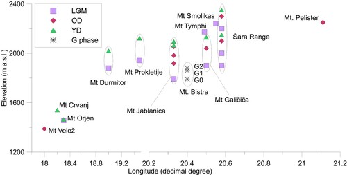
Table 2. Averaged ELA values found in the Balkan area by previous authors. LGM: Last Glacial Maximum; OD: Oldest Dryas; YD: Younger Dryas; AAR: Accumulation Area Ratio; AABR: Area-Altitude Balance Ratio. See for locations.
Despite the very low ELA values of Mt Orjen (Montenegro), Mt Velež, and Mt Crvanj (Bosnia Herzegovina), and the very high LGM values in the Greek mountains (Mt Tymphi and Mt Smolikas), the ELA values in the Balkans tend to be consistent. CitationHughes et al. (2010) and CitationRea et al. (2020) explain the low ELA values of Mt Orjen (LGM and YD) with the closeness to the source of large amounts of humidity in the Adriatic Sea. Zebre et al. (Citation2019) ascribe the very low values of OD and YD ELA in Mt Velež and Mt Crvanj to the orographic position of the studied area close to the Adriatic coast, and to the specific topoclimatic conditions. The high ELA values (LGM) of the Greek Mountains could be due to their southernmost location, relatively far from relevant cyclonic areas. The ELAs of the three glacial phases described for the Bistra Mountain can be compared to the values derived from previous studies ().
A recalculation of all the ELA values with a common and semi-automatic method would certainly be necessary for a more accurate comparison (CitationRea et al., 2020; CitationRibolini et al., 2018); however, the Balkan ELAs, at least those of the North Macedonia mountain, show a longitude increase. This is particularly evident for the phases attributed to the Younger Dryas. In this respect, the ELAs retrieved from the paleo-glaciers in the Bistra mountain seem to be compressed in a short elevation range, with a good correspondence between the ELA of the G0 phase and the one attributed to the LGM in the Jablanica Mountains (ca. 50 km from Mt. Bistra). The 100–150 m of difference between the ELAs of the G0 phase and those relative to the LGM in the Galičiča Mountains and in the Šara Range could be due to the high sensitivity of the ELA, to inaccuracies in the reconstruction of very small glaciers, or to the different methods adopted for its calculation. Excluding the values of Mt Orjen and of the Greek mountains, the other ELAs do not show a coherent variation with latitude.
Accepting as valid the hypothesis of a correspondence between G0 and LGM, it is evident that the two Lateglacial phases of readvance/standstill characterized the deglaciation of the Bistra Mountains. According to the regional results, these two phases can be tentatively attributed to the cold events of the Oldest Dryas and of the Younger Dryas.
6. Conclusions
This map is to be intended as a basis for ongoing works where dating techniques will constrain the recognized glacial phases, improving knowledge of the environmental evolution of this sector of the Balkans. In general, this research aims at adding a new element to the complex picture of glacier evolution in the circum-Mediterranean mountains. The results obtained by comparing data from different terrestrial and marine proxies (i.e. speleothems, paleolimnology, biostratigraphy of marine cores among others) may contribute to the study of climate evolution during the Late Pleistocene.
The outcomes of the geomorphological survey of the Bistra mountain confirm that this region records surface evidences related to the most striking climate variations of the Late Pleistocene, that is, the formation of glaciers during the Late Pleistocene. Indeed, although this area receives, and has received (CitationRea et al., 2020) a limited amount of precipitation because of the orographic effects caused by the reliefs facing the Adriatic Sea (e.g. Montenegro mountains), three phases of glacial advance/standstill are recognized by mapping frontal moraines. An ELA comparison across the Balkans supports a tentative chronological attribution to the Last Glacial Maximum and to the following cold events that characterized the Pleistocene termination (Oldest Dryas and Younger Dryas). Furthermore, the results point out that Mount Bistra was, at some point in its climatic history, close to the climatic limit for the existence of glaciers. Depending on local topoclimatic factors, this equilibrium could shift towards glacial or periglacial conditions, with the consequent formation of glaciers (moraines) or permafrost features (rock glaciers).
Calculation of the ELA values for the reconstructed glaciers made it possible to implement a dataset that could be used for future regional comparisons. At first examination, a correlation seems to emerge with the ELA values of other glaciers in the Balkan region, at least for the oldest phase identified in the Bistra Mountain (G0-LGM). The distribution of ELA values on a regional scale also seems to agree with general circulation patterns, which in this Mediterranean area are dominated by sources of humidity in the Adriatic Sea and by the orographic barrier formed by the Balkan mountains.
Software
Google Earth® was used to perform remote sensing analysis. QGIS 3.10 was used to draw the geomorphological features, to create the geodatabase and to obtain the final layout. ArcGis10® was used to run the Pellitero tool for ELA calculations.
Map_rev.pdf
Download PDF (18.6 MB)Acknowledgements
The authors are grateful to the reviewers for their comments and suggestions, which helped to improve and clarify the text.
Disclosure statement
No potential conflict of interest was reported by the author(s).
Data availability statement
The Vector dataset supporting this map can be obtained by request to Ilaria Isola.
Additional information
Funding
Related Research Data
References
- Andonovski, T. (1977). Underground karst landforms in the Radika Valley. Ann Fac Geogr Skopje, 23, 97–120. (in Macedonian).
- Arsovski, M. (1960). Some characteristics of the tectonic features of the central part of Pelagonian horst anticlinorium and its relation to the Vardar Zone. Papers of Geologic Survey of SRM, Skopje 7:76–94 (in Macedonian).
- Bakke, J., & Nesje, A. (2011). Equilibrium-line altitude (ELA). In V. Singh, P. Singh, & U. Haritashya (Eds.), Encyclopedia of snow, ice and glaciers (pp. 268–277). Springer.
- Baroni, C., Guidobaldi, G., Salvatore, M. C., Christl, M., & Ivy-Ochs, S. (2018). Last glacial maximum glaciers in the Northern Apennines reflect primarily the influence of southerly storm-tracks in the western Mediterranean. Quaternary Science Reviews, 197, 352–367. https://doi.org/https://doi.org/10.1016/j.quascirev.2018.07.003
- Cvijić, J. (1917). L’epoque glaciaire dans la Peninsule Balkanique. Annales de Geographie, 26(141), 189–218.
- Djurović, P. (2009). Reconstruction of the Pleistocene glaciers of Mt. Durmitor in Montenegro. Acta Geographica Slovenica, 49(2), 263–289. https://doi.org/https://doi.org/10.3986/AGS49202
- Federici, P. R., Granger, D. E., Pappalardo, M., Ribolini, A., Spagnolo, M., & Cyr, A. J. (2008). Exposure age dating and Equilibrium Line Altitude reconstruction of an egesen moraine in the Maritime Alps, Italy. Boreas, 37(2), 245–253. https://doi.org/https://doi.org/10.1111/j.1502-3885.2007.00018.x
- Federici, P. R., Granger, D. E., Ribolini, A., Spagnolo, M., Pappalardo, M., & Cyr, A. J. (2012). Last glacial maximum and the gschnitz stadial in the Maritime Alps according to 10Be cosmogenic dating. Boreas, 41(2), 277–291. https://doi.org/https://doi.org/10.1111/j.1502-3885.2011.00233.x
- Federici, P. R., Ribolini, A., & Spagnolo, M. (2017). Glacial history of the Maritime Alps from the Last Glacial Maximum to the little ice age. In P. D. Hughes & J. C. Woodward (Eds.), Quaternary glaciation in the Mediterranean mountains (Vol. 433, pp. 137–159). Geological Society. https://doi.org/https://doi.org/10.1144/SP433.9
- Finsinger, W., & Ribolini, A. (2001). Late glacial to Holocene deglaciation of the Colle del Vei del Bouc-Colle del Sabbione Area (Argentera Massif, Maritime Alps, Italy-France).
- French, H. M. (2017). The periglacial environment. John Wiley & Sons. doi:https://doi.org/10.1002/9781119132820.
- Giraudi, C. (2012). The Campo Felice late Pleistocene glaciation (Apennines, central Italy). Journal of Quaternary Science, 27(4), 432–440. https://doi.org/https://doi.org/10.1002/jqs.1569
- Giraudi, C., Bodrato, G., Ricci Lucchi, M., Cipriani, M., Villa, I. M., Giaccio, B., & Zuppi, G. M. (2011). Middle and late Pleistocene glaciations in the Campo Felice basin (central Apennines, Italy). Quaternary Research, 75(1), 219–230. https://doi.org/https://doi.org/10.1016/j.yqres.2010.06.006
- GLCM - Gruppo di Lavoro per la Cartografia Geomorfologica. (1994). Carta Geomorfologica d’Italia - 1:50.000. Guida al rilevamento. Quaderni Servizio Geologico Nazionale, 4(III), 42.
- Gromig, R., Mechernich, S., Ribolini, A., Wagner, B., Zanchetta, G., Isola, I., Bini, M., & Dunai, T. J. (2018). Evidence for a Younger Dryas deglaciation in the Galicica mountains (FYROM) from cosmogenic 36Cl. Quaternary International, 464, 352–363. https://doi.org/https://doi.org/10.1016/j.quaint.2017.07.013
- Haeberli, W., & Beniston, M. (1998). Climate change and its impacts on glaciers and permafrost in the Alps. Ambio, 27(4), 258–265.
- Hedding, D. W. (2016). Pronival ramparts: A review. Progress in Physical Geography: Earth and Environment, 40(6), 835–855. https://doi.org/https://doi.org/10.1177/0309133316678148
- Hughes, P. D. (2007). Recent behaviour of the Debeli Namet glacier, Durmitor, Montenegro. Earth Surface Processes and Landforms, 32(10), 1593–1602. https://doi.org/https://doi.org/10.1002/esp.1537
- Hughes, P. D. (2011). Mediterranean glaciers and glaciation. In V. P. Singh, P. Singh, & U. K. Haritashya (Eds.), Encyclopedia of snow, ice and glaciers: Encyclopedia of earth sciences series (pp. 726–730). Springer. https://doi.org/https://doi.org/10.1007/978-90-481-2642-2_640
- Hughes, P. D., & Woodward, J. C. (2008). Timing of glaciation in the Mediterranean mountains during the last cold stage. Journal of Quaternary Science, 23(6-7), 575–588. https://doi.org/https://doi.org/10.1002/jqs.1212
- Hughes, P. D., & Woodward, J. C. (2017). Quaternary glaciation in the Mediterranean mountains: A new synthesis. Geological Society, London, Special Publications, 433(1), 1–23. https://doi.org/https://doi.org/10.1144/SP433.14
- Hughes, P. D., Woodward, J. C., & Gibbard, P. L. (2006a). Quaternary glacial history of the Mediterranean mountains. Progress in Physical Geography: Earth and Environment, 30(3), 334–364. https://doi.org/https://doi.org/10.1191/0309133306pp481ra
- Hughes, P. D., Woodward, J. C., & Gibbard, P. L. (2006b). The last glaciers of Greece. Zeitschrift für Geomorphologie, 50(1), 37–61. https://doi.org/https://doi.org/10.1127/zfg/50/2006/37
- Hughes, P. D., Woodward, J. C., van Calsteren, P. C., & Thomas, L. E. (2011). The glacial history of the Dinaric Alps, Montenegro. Quaternary Science Reviews, 30(23-24), 3393–3412. https://doi.org/https://doi.org/10.1016/j.quascirev.2011.08.016
- Hughes, P. D., Woodward, J. C., van Calsteren, P. C., Thomas, L. E., & Adamson, K. R. (2010). Pleistocene ice caps on the coastal mountains of the Adriatic Sea. Quaternary Science Reviews, 29(27-28), 3690–3708. https://doi.org/https://doi.org/10.1016/j.quascirev.2010.06.032
- Humlum, O. (1982). Rock glacier types on Disko, central West Greenland. Geografisk Tidsskrift-Danish Journal of Geography, 82(1), 59–66. https://doi.org/https://doi.org/10.1080/00167223.1982.10649152
- Huss, M., & Fischer, M. (2016). Sensitivity of very small glaciers in the Swiss Alps to future climate change. Frontiers in Earth Science, 4. https://doi.org/https://doi.org/10.3389/feart.2016.00034
- Isola, I., Bini, M., Ribolini, A., Pappalardo, M., Consoloni, I., Fucks, E., Boretto, G., Ragaini, L., & Zanchetta, G. (2011). Geomorphologic map of northeastern sector of San Jorge gulf (Chubut, Argentina). Journal of Maps, 7(1), 476–485. https://doi.org/https://doi.org/10.4113/jom.2011.1203
- Isola, I., Bini, M., Ribolini, A., Zanchetta, G., & D’Agata, A. L. (2017). Geomorphology of the Ceyhan river lower plain (Adana Region. Journal of Maps, 13(2), 133–141. https://doi.org/https://doi.org/10.1080/17445647.2016.1274684
- Isola I., Ribolini A., Zanchetta G., Bini M., Regattieri E., Drysdale R.N., Hellstrom J.C., Bajo P., Montagna P., Pons-Branchu E. (2019). Speleothem U/Th age constraints for the last glacial conditions in the Apuan Alps, northwestern Italy. Palaeogeography, Palaeoclimatology, Palaeoecology, 518, 62–71. https://doi.org/https://doi.org/10.1016/j.palaeo.2019.01.001
- Kolčakovski, D. (1999). Glacial and periglacial relief on the mountain Jablanica. Annu Inst Geogr FNSM Skopje, 33, 15–38.
- Kuhlemann, J., Milivojevic, M., Krumrei, I., & Kubik, P. (2009). Last glaciation of the Sara Range (Balkan peninsula): increasing dryness from the LGM to the holocene. Austrian Journal of Earth Sciences, 102(1), 146–158.
- Leontaritis, A. D., Kouli, K., & Pavlopoulos, K. (2020). The glacial history of Greece: a comprehensive review. Mediterranean Geoscience Reviews, 2(1), 65–90.
- Manakovikj, D., & Andonovski, T. (1983). The relief of Bistra Mountain. Bistra I, MASA, Skopje, 37–73. (in Macedonian).
- Messerli, B. (1967). Die eiszeitliche und die gegenwärtige vergletscherung im mittelmeerraum. Geographica Helvetica, 22(3), 105–228. https://doi.org/https://doi.org/10.5194/gh-22-105-1967
- Milevski, I. (2014). Slope Values Accuracy vs Resolution of the Digital Elevation Models (Example of the Republic of Macedonia). Proceedings of 5th ICC-GIS Conference; Eds: Bandrova T & Konecny M., Vol. 2, Varna, 568-575.
- Milevski, I. (2015). Digital model of the mean annual temperature and precipitation of the Republic of Macedonia. Geographical Reviews, 48.
- Milevski, I. (2016). Morphometry and land use on high mountains in the Republic of Macedonia. In G. Zhelezov (Ed.), Sustainable development in mountain regions (pp. 67–78). Springer. https://doi.org/https://doi.org/10.1007/978-3-319-20110-8_6
- Milivojević, M., Menković, L., & Ćalić, J. (2008). Pleistocene glacial relief of the central part of Mt. Prokletije (Albanian Alps). Quaternary International, 190(1), 112–122. https://doi.org/https://doi.org/10.1016/j.quaint.2008.04.006
- Oerlemans, J. (2001). Glaciers and climate change. CRC Press. 160 pp.
- Oerlemans, J. (2005). Extracting a climate signal from 169 glacier records. Science, 308(611), 675–677. https://doi.org/https://doi.org/10.1126/science.1107046
- Ohmura, A., Kasser, P., & Funk, M. (1992). Climate at the equilibrium line of glaciers. Journal of Glaciology, 38(130), 397–411. https://doi.org/https://doi.org/10.1017/S0022143000002276
- Osmaston, H. A. (2005). Estimates of glacier equilibrium line altitudes by the area×altitude, the area×altitude balance ratio and the area×altitude balance index methods and their validation. Quaternary International, 138-139, 22–31. https://doi.org/https://doi.org/10.1016/j.quaint.2005.02.004
- Pellitero, R., Rea, B. R., Spagnolo, M., Bakke, J., Hughes, P., Ivy-Ochs, S., Lukas, S., & Ribolini, A. (2015). A GIS tool for automatic calculation of glacier equilibrium-line altitudes. Computers & Geosciences, 82, 55–62. https://doi.org/https://doi.org/10.1016/j.cageo.2015.05.005
- Porter, S. C. (1975). Equilibrium line altitudes of late Quaternary glaciers in the Southern Alps. New Zealand. Quaternary Research, 5, 27–47.
- Rea, B. R. (2009). Defining modern day area–altitude balance ratios (AABRs) and their use in glacier–climate reconstructions. Quaternary Science Reviews, 28(3-4), 237–248. https://doi.org/https://doi.org/10.1016/j.quascirev.2008.10.011
- Rea, B., Pellitero, R., Spagnolo, M., Huhes, P., Ivy-Ochs, S., Renssen, H., Ribolini, A., Bakke, J., Lukas, S., & Braithwaite, R. (2020). Atmospheric circulation over Europe during the Younger dryas. Science Advances, 6(50), 1–13. https://doi.org/https://doi.org/10.1126/sciadv.aba4844
- Republička geodetska uprava Skopje. (1972). Lazarpole Topografska karta 1:25.000. Vojnogeografski insitut.
- Republička geodetska uprava Skopje. (1978). Mavrovo Topografska karta 1:25.000. Vojnogeografski insitut.
- Ribolini, A., Bini, M., Isola, I., Spagnolo, M., Zanchetta, G., Pellitero, R., … Milevski, I. (2018). An Oldest Dryas glacier expansion on mount Pelister (former yugoslavian Republic of Macedonia) according to10Be cosmogenic dating. Journal of the Geological Society, 175(1), 100–110. https://doi.org/https://doi.org/10.1144/jgs2017-038
- Ribolini, A., Isola, I., Zanchetta, G., Bini, M., & Sulpizio, R. (2011). Glacial features on the Galicica mountains. Macedonia: Preliminary Report. Geografia Fisica e Dinamica Quaternaria, 34, 247–255.
- Ruszkiczay-Rüdiger, Z., Kern, Z., Temovski, M., Madarász, B., Milevski, I., Braucher, R., & Team, A. S. T. E. R. (2020). Last deglaciation in the central Balkan Peninsula: Geochronological evidence from the Jablanica Mt. (North Macedonia). Geomorphology, 351, 106985. https://doi.org/https://doi.org/10.1016/j.geomorph.2019.106985
- Spagnolo, M., & Ribolini, A. (2019). Glacier extent and climate in the Maritime Alps during the Younger Dryas. Palaeogeography, Palaeoclimatology, Palaeoecology, 536. https://doi.org/https://doi.org/10.1016/j.palaeo.2019.109400
- Temovski, M., Madarász, B., Kern, Z., Milevski, I., & Ruszkiczay-Rüdiger, Z. (2018). Glacial geomorphology and preliminary glacier reconstruction in the Jablanica mountain, Macedonia, central Balkan peninsula. Geosciences, 8(7), 270. https://doi.org/https://doi.org/10.3390/geosciences8070270
- Vasilevski, D. (2011). Geomorphology of the National Park Mavrovo. In: Study on reevaluation of protected area Mavrovo. Oxfam Italia, Mavrovo National Park, Ministry of Environment and Physical Planning. Skopje, 38–62. (in Macedonian).
- Žebre, M., Sarıkaya, M. A., Stepišnik, U., Yıldırım, C., & Çiner, A. (2019). First 36Cl cosmogenic moraine geochronology of the Dinaric mountain karst: Velež and Crvanj mountains of Bosnia and Herzegovina. Quaternary Science Reviews, 208, 54–75. https://doi.org/https://doi.org/10.1016/j.quascirev.2019.02.002