
ABSTRACT
Detailed geological mapping of the Urtier Valley in the Western Alps allowed to realize a new geological map 1:10.000 in scale. In the mapped area, a complete nappe stack of the axial part of the Alpine belt crops out. The study focused on the two units derived from the Piemonte-Ligurian oceanic domain, Broillot and Bardonney units, for which, in addition to the classic petrographic and structural considerations, a lithostratigraphic approach was applied. The lithostratigraphic approach, combined with structural analysis, led to reconstruct a nappe stacking significantly different from that generally proposed for the Western Alps. In the Urtier Valley in fact, the eclogite facies units are at the top of the nappe pile, overlapped on the blueschist facies units. This anomalous stacking order could be explained by interpreting the study area as an inverted limb of a regional fold with the eclogite facies units at the core.
1. Introduction
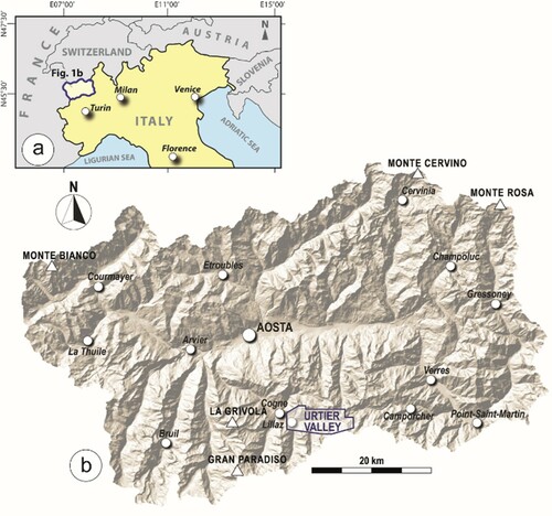
In the Italian side of the Western Alps, the Urtier Valley is one of the three great valleys open up to the head of the Cogne valley, a dextral tributary of the Aosta Valley (). The Urtier Valley trends EW and extends for about 10 km from the watershed that divides it from the Champorcher Valley, to its confluence with Cogne Valley near Lillaz village.
Figure 1. Geographic location of the study area. (a) Schematic representation of northern Italy and neighboring countries, with the Aosta Valley region highlighted. (b) Digital Terrain Model of the Aosta Valley region, with the mapped area of Urtier Valley highlighted.
In the Urtier Valley the complete nappe stack of the axial part of the Alpine belt is exposed, from the lowermost Gran Paradiso Penninic basement, the superposed oceanic units derived from the Piemonte-Ligurian oceanic domain, up to the uppermost Sesia continental basement slivers. This nappe stack is the result of the convergence between the European lower plate and Adria upper plate that, starting in the Cretaceous, led to the closure of the interposed Piemonte-Ligurian oceanic domain within a subduction zone, resulted in the continental collision during the Cenozoic (CitationArgand, 1916; CitationButler et al., Citation2013; CitationDewey et al., Citation1989; CitationRosenbaum & Lister, Citation2005). Geodynamic models and paleogeographic reconstructions provide a foreland-directed nappe stack, related to a subduction process that started in the innermost units of Adria domain and then progressively involving the more external units of oceanic domain and finally the European passive margin (CitationDal Piaz et al., Citation2003; CitationSchmid et al., Citation2004).
This geodynamic evolution seems to be confirmed by the distribution of radiometric age data corresponding to peak-pressure mineral assemblages, which progressively become younger from the continental basement units of the Adria plate at the top, to the lowermost continental units derived from the European margin (CitationAmato et al., Citation1999; CitationDal Piaz et al., Citation2001; CitationInger et al., Citation1996; CitationLapen et al., Citation2003, Citation2006; CitationLiati et al., Citation2002, Citation2005; CitationRamsbotham et al., Citation1994; CitationRubatto et al., Citation1999; CitationThöni, Citation1999; CitationVilla et al., Citation2014).
The interposed tectonic units derived from the Piemonte-Ligurian oceanic domain are characterized by intermediate radiometric ages, and are classically subdivide into two different nappe systems (), a structurally higher blueschist facies unit (i.e. the Combin Unit) superposed on an eclogite facies unit (i.e. the Zermatt-Saas Unit) (CitationBearth, Citation1967). This structural setting, described for the first time on the Swiss Alps and in the northern Aosta Valley, was considered reliable for the whole belt and therefore extended to the southern Aosta Valley and to the French-Italian Alps (e.g. CitationBalestro et al., Citation2019; CitationBallèvre & Merle, Citation1993; CitationDal Piaz, Citation1999; CitationMichard et al., Citation1996).
Figure 2. (a) Tectonic map of the Western Alps (modified after CitationBeltrando et al., Citation2014). A: Argentera massif; GP: Gran Paradiso Unit; MB: Mont Blanc massif; MR: Monte Rosa Unit; PM: Pelvoux massif; TPB: Tertiary Piemonte Basin. Trace of cross-section in (b) is indicated. (b) Simplified cross-section across the Gran Paradiso massif (modified after CitationBucher et al., Citation2004; CitationLe Bayon & Ballèvre, Citation2006; CitationPognante, Citation1989; CitationSchmid & Kissling, Citation2000). IL: Insubric Line; ICL: Internal Canavese Line. (c) Tectonic sketch map of the Aosta Valley (compiled after CitationBattiston et al., Citation1984; CitationBigi et al., Citation1990; CitationBucher et al., Citation2004; CitationDal Piaz, Citation1999, Citation2001; CitationDal Piaz et al., Citation1979, Citation2008; CitationElter, Citation1987; CitationLe Bayon & Ballèvre, Citation2006). The study area is indicated. ARL: Aosta Ranzola Line; ICL: Internal Canavese Line.
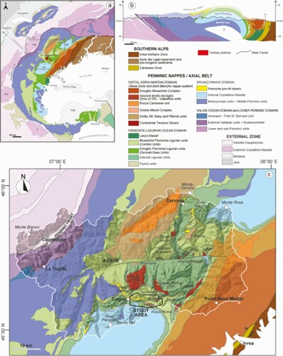
Actually, the Piemonte-Ligurian nappe stack in the southern Aosta Valley has been proven to be more complex than expected, often leading to conflicting interpretations (e.g. CitationBallèvre et al., Citation1986; CitationBousquet, Citation2008; CitationDal Piaz et al., Citation2008; CitationPleuger et al., Citation2007).
An example of this complexity is represented in the Urtier Valley, where a structural stacking characterized by the eclogite facies oceanic units superposed on the blueschist facies oceanic units was proposed (CitationEllero & Loprieno, Citation2014, Citation2018; CitationLoprieno et al., Citation2009).
In this contribution, a new geological map of the Urtier Valley area is presented, accompanied by geological cross-sections. The geological mapping was carried out paying particular attention to the lithostratigraphic characters of the Piemonte-Ligurian Units and to the reconstruction of the geometric relationships between the tectonic units, with the aim of contributing to a better understanding of the distribution, deformation history and structural setting of the Piemonte-Ligurian Units in the southern side of the Aosta Valley.
Among all possible methodological approaches, accurate geological mapping has been proven to be one of the most important tools for a reliable geometric reconstruction of the nappe pile that represents the essential basis for any geodynamic model.
2. Geological setting of the Urtier Valley
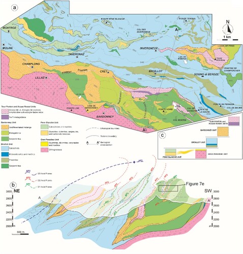
In the Urtier Valley, five different tectono-metamorphic units were distinguished (). From bottom to top, they are: (i) the Gran Paradiso Unit; (ii) the Pene Blanche Unit; (iii) the Broillot Unit; (iv) the Bardonney Unit; (v) the Tour Ponton and Acque Rosse units (CitationEllero & Loprieno, Citation2014, Citation2018).
Figure 3. (a) Structural-geological map of the Urtier Valley, (b) geological cross-section and (c) sketch of the nappe stacking proposed for the study area. Modified by CitationEllero and Loprieno (2018).
The lowermost Gran Paradiso Unit belongs to Briançonnais-type Penninic basement resulting from the originary European continental margin. This unit represents the southern limit of the mapped area and consists of augen gneisses derived from late-Variscan granitoids intruded into metasedimentary rocks (Gneiss Minuti) (CitationBertrand, Citation1968; CitationCompagnoni et al., Citation1974). The Gran Paradiso Unit is characterized by an eclogite facies metamorphism dated at c. 33.7 Ma (CitationRadulescu et al., Citation2009).
The overlying Pene Blanche Unit consists of a Briançonnais-like facies metasedimentary succession, which start with Lower Triassic quartzite and Liassic marble unevenly preserved along the stratigraphic contact with the Gran Paradiso basement (CitationEllero & Loprieno, 2018). The metasedimentary succession continues with Lower Triassic to Liassic limestones (CitationElter, 1972), followed upward by Liassic calcschists and marbles not associated with ophiolites, outcropping in the northern side of the Urtier Valley as dismembered tectonic slices (cfr. ‘Faisceau de Cogne’ of CitationElter, 1972). For the Pene Blanche Unit an eclogite facies metamorphism was suggested (CitationBeltrando et al., Citation2008).
Upward, two Piemonte-Ligurian tectonic units have been distinguished in the Urtier Valley, the lowermost Broillot Unit and the uppermost Bardonney Unit (CitationEllero & Loprieno, 2018). These two Piemonte-Ligurian units represent the main topic of this study and therefore they will be described in detail in the following section.
The top of the nappe pile is represented by the Tour Ponton and Acque Rosse units (CitationNervo & Polino, Citation1976; CitationPaganelli et al., Citation1995), which represent continental tectonic slivers of Sesia zone occurring within the Piemonte-Ligurian units. These units consist of albite gneisses and garnet-bearing micaschists, with minor meta-aplites, boudins of amphibolites and bodies of mafic rocks affected by Alpine high-pressure conditions, often preserving evidences of pre-Alpine metamorphism under granulite to amphibolite facies conditions (CitationArgand, Citation1911; CitationBallèvre et al., Citation1986; CitationBattiston et al., Citation1984; CitationDal Piaz et al., Citation1979, Citation1983; CitationDal Piaz & Nervo, Citation1971; CitationFassmer et al., Citation2016; CitationPennacchioni, Citation1991, Citation1996).
3. Methods
The geological map results from original fieldwork at 1:10.000 scale realized during Master’s Degree theses by A. Loprieno and A. Ellero (CitationEllero, Citation1994; CitationLoprieno, Citation1994), subsequently integrated and corrected during several additional mapping performed by the authors at 1:10.000 scale. Geological mapping was performed using topographic maps (Carta Tecnica Regionale) produced by the Regione Autonoma Valle d’Aosta, represented on a vector topographic map derived from the CTRN (Carta Tecnica Regionale Numerica 1:10.000; Coordinate System represented in meters ED50-European Datum 1950, UTM Zone 32 Nord). These topographic maps have been scaled at 1:12.500 and the raster format were digitized to be used for the Main Map.
Structural elements documented in the field (e.g. foliations, fold axes, stretching lineations) are represented in the Main Map using a synoptic representation that allows differentiating their tectonic superposition order. The Quaternary geology resulted from original mapping. The Main Map is accompanied by (i) a tectonic sketch map of the study area where the main fold axial planes are shown, (ii) five geological cross-sections and (iii) two panoramic photos where the nappe pile of the area is highlighted.
Unlike the methodology usually applied for the study of the Piemonte-Ligurian Units units, in which the different tectonic units are distinguished mainly by their different metamorphic grade, we used a lithostratigraphic approach combined with structural and petrologic analyses. The evidence on the outcrops of lithological boundaries that retain the original meaning of primary stratigraphic contacts, associated to the knowledge of the stratigraphic succession that characterizes the homologous oceanic units of the Northern Apennines (CitationDecandia & Elter, 1972; CitationElter, Citation1975), allowed us to use a stratigraphic approach, based on concepts such as stratigraphic polarity or younging direction, to perform an accurate reconstruction of the geometries that characterize the nappe pile. In this work, we therefore felt authorized to use the term ‘stratigraphic’, despite being aware of the intense re-elaboration due to the tectonic-metamorphic evolution.
4. The Piemonte – Ligurian units of the Urtier Valley
In the Urtier Valley have been recognized two tectonics units belonging to the Piemonte – Ligurian oceanic domain, the Broillot Unit and the Bardonney Unit (CitationEllero & Loprieno, 2018). These units have a different metamorphic evolution. The Broillot Unit is characterized by a general metamorphic retrogression under greenschist facies conditions.
Quantitative petrological analyses are lacking for the Broillot Unit, with the only indications on the peak metamorphism deriving from qualitative petrological studies, which interpreted the garnet-chloritoid paragenesis of micaschists as indicative of blueschist facies conditions (CitationBousquet, Citation2008; CitationEllero & Loprieno, 2018), or, alternatively, of eclogite facies conditions (CitationBeltrando et al., Citation2008).
Instead, in the Bardonney Unit, the peak metamorphic conditions correspond to the eclogite facies, as evidenced by garnet + omphacite + rutile paragenesis preserved in meta-Fe-Ti gabbros included in the Mg-Fe gabbro blocks. A complex metamorphic retrogression history, characterized by several stages of recrystallization, can be observed starting from the replacement of garnet + omphacite by glaucophane + clinozoisite, continuing with barroisite + actinolite replacing glaucophane, and finally with the formation of chlorite, epidote, albite and titanite. The tectono-metamorphic history of the Bardonney Unit is therefore characterized by a metamorphic peak under eclogite-facies conditions, followed by a retrogression with progressive decrease of pressure, from blueschist- to greenschist-facies conditions, respectively (CitationEllero & Loprieno, 2018; CitationTartarotti et al., Citation2019a).
Another important difference between the two tectonic units consists in a different lithostratigraphic succession that, in the case of Broillot Unit, maintains its original stratigraphic order despite the complex deformation history. It is precisely these different lithostratigraphic characters that will be described and interpreted in this study.
4.1. The Broillot Unit
The Broillot Unit mostly crops out in central and northern parts of the mapped area, whereas some small and discontinuous slices cropping out directly above the Gran Paradiso Unit in Bardonney and Acque Rosse valleys (see the Main Map; ). In the Chatillon sheet of the new Geological Map of Italy (CitationDal Piaz et al., Citation2008) this unit is generally included within the Zermatt-Saas Unit.
However, the only study that deals specifically with the Piemonte-Ligurian units of this area, describes a ‘Blueschist facies Piemonte unit’ cropping out in the Urtier Valley, correlating this unit, which partly corresponds to the Broillot Unit, with the Combin Unit (CitationBeltrando et al., Citation2008).
The most important feature of this unit is the well-preserved lithostratigraphic succession that is diagnostic of a typical oceanic crust associated with its sedimentary cover ((a)). The ophiolitic basement is mainly represented by prasinites and minor serpentinites (Colonna iron-mine area, NE of Cogne). Prasinites are interpreted as metamorphic equivalent of originary basalts. They are characterized by greenschists paragenesis, consisting of albite, chlorite, green amphibole, epidote, garnet and titanite. In some cases, prasinites show ovardite textures, characterized by porphyroblast albite with inclusions of green-brown amphibole, titanite, epidote and chlorite. The ultramafic rocks consist of antigorite serpentinites, with subordinate magnetite and relics of pyroxenes.
Figure 4. Outcropping features of the Broillot Unit. (a) Preserved stratigraphic succession with ophiolitic basement, consisting of prasinite, and its sedimentary cover. The stratigraphic polarity of the outcrop is reverse. (b) Quartzite, interpretable as the metamorphic correspondent of original radiolarites, (c) impure marble and (d) calcschists alternated with micaschists of the Taveronnaz Schist Formation. The succession continues upward with (e) the fine-grained metasandstones of Cret Schist Formation, characterized by (f) diffuse intercalations of detrital prasinites consisting of basaltic metasandstones.
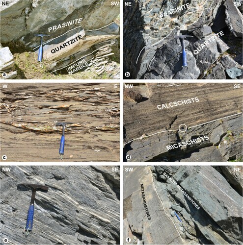
Upwards follows a typical oceanic metasedimentary succession, with quartzites, marbles and calcschists, representing the metamorphic rocks derived from sedimentary succession made of Cherts, Calpionella limestones and Palombini shales. This pelagic succession was well defined as the sedimentary cover of an ophiolitic basement in the Internal Liguride units in the Northern Apennines (CitationDecandia & Elter, Citation1969, Citation1972; CitationElter, Citation1975). Several stratigraphic sequences of Piemonte-Ligurian unit of the Western Alps have been correlated to this pelagic succession (CitationBurroni et al., Citation2003; CitationDeville et al., Citation1992; CitationElter, Citation1971; CitationFesta et al., Citation2015; CitationLagabrielle et al., Citation2015; CitationLagabrielle & Polino, Citation1988; CitationLemoine, Citation1971; CitationPolino & Lemoine, Citation1984; CitationTartarotti et al., Citation2017a). Quartzites ((b)) consists of quartz, and minor white mica, chlorite, calcite, epidote, titanite and diffuse garnet porphyroblast characterized by curving trails of quartz and rutile inclusions. Marbles are impure, ((c)) with variable amounts of quartz, white mica, chlorite, epidote and tourmaline. Upwards, the Taveronnaz Schist Formation (CitationEllero & Loprieno, 2018) follows, consisting mainly of calcschists alternated to metric-thick layers of quartz-micaschists ((d)) containing white mica, quartz, chloritoid and garnet porphyroblast with inclusions of white mica, quartz, chloritoid and rutile. At the top of the stratigraphic succession of the Broillot Unit is the Cret Schist Formation (CitationEllero & Loprieno, 2018), constituted by an alternation of metasandstones, calcschists and micaschists ((e)). In this sequence, there are widespread levels of prasinites ((f)), characterized by anomalous composition, with important contents of calcite, quartz, white mica and tourmaline, that suggests a sedimentary origin of these rocks as turbiditic deposits (basaltic sandstones) fed by the erosion of ophiolitic rocks.
4.2. The Bardonney Unit
The Bardonney Unit crops out on the southern flank of Urtier Valley, and in the Tour Ponton area, below the continental basement sliver (see the Main Map; ). This unit partly corresponds to the ‘Eclogite facies Piemonte unit’ described by CitationBeltrando et al. (Citation2008), correlated to the Zermatt-Saas unit by these authors. The Bardonney Unit can be partly correlated also to the ‘Grivola-Urtier unit’ (CitationDal Piaz et al., Citation2008; CitationTartarotti et al., Citation2019b), which is instead separate by the Zermatt-Saas unit.
The distinctive character of the Bardonney Unit is the total absence of stratigraphic order, with a chaotic tectono-stratigraphic complex, characterized by ophiolitic blocks of variable size, origin and lithology, interpreted as originary olistoliths, embedded in a sedimentary matrix (CitationEllero & Loprieno, 2018). The largest ophiolitic blocks reach cartographic scale and consist of serpentinites and metagabbros (). The serpentinites are foliated and show a paragenesis of serpentine, chlorite, amphibole, pyroxene (diopside), epidote, metamorphic olivine, titanian clinohumite and magnetite. The serpentinite blocks are associated with a monogenic metabreccia consisting of clasts of serpentinite embedded in a heterogeneous carbonate matrix ((b)), characterized by calcite mixed with serpentine, chlorite, epidote, garnet, amphibole, clinopyroxene, white mica, albite, titanian clinohumite, tourmaline and titanite, suggesting a detrital origin for these deposits that can be interpreted as an originary reworked meta-ophicalcite. A similar interpretation has been proposed for many other locations within the Piemonte-Ligurian domain relicts in the Western Alps (e.g. CitationLafay et al., Citation2017; CitationLemoine, 1980; CitationTartarotti et al., Citation2017b, Citation2019a).
Figure 5. Ophiolitic blocks of Bardonney Unit. (a) Serpentinite olistoliths of Loie lake, associated to (b) metaophicalcite with serpentinite clasts embedded in a carbonate matrix. (c) Eclogitic Fe-Ti gabbro olistolith of Pointe Noire.
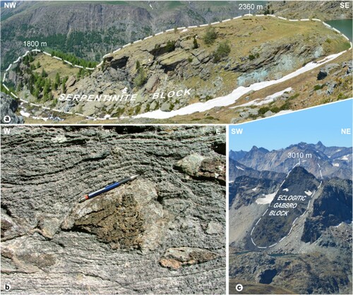
The metagabbro blocks consist of Mg-Fe gabbro containing pods of eclogitic Fe-Ti metagabbros characterized by omphacite, garnet and rutile assemblage.
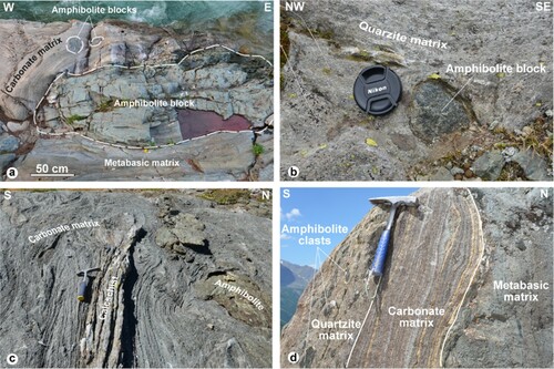
Ophiolitic blocks of smaller size, ranging from centimeter to metric scale, generally consist of amphibolites ((a,b)), with a paragenesis characterized by amphibole, chlorite, epidote, albite, garnet, rutile and/or titanite. In well-preserved ophiolitic blocks, the amphibole consists of glaucophane usually associated with garnet and rutile. Blocks in matrix can be derived not only by the ophiolitic basement, but also from Piemonte-Ligurian sedimentary sequence. In this case, the slide-blocks consist of marbles and calcschists associated to amphibolites embedded in a carbonate matrix ((c)). The matrix of the chaotic complex consists of alternate layers of carbonate, quartzite and metabasite, likely derived from the erosion of ophiolitic basement and sedimentary cover ((d)). Carbonate layers are calcschists and impure marble, composed by calcite, white mica, quartz, chlorite, epidote and titanite. Garnet porphyroblasts are common, containing inclusions of glaucophane, rutile, clinopyroxene and quartz. The quartzite matrix is represented by metasandstones containing quartz, white mica, chlorite, garnet, amphibole, albite, rutile and/or titanite. Metabasic matrix consists of prasinites and amphibolite layers, generally alternated with metasandstones or calcschists. Metabasites are composed by amphibole, garnet, albite, zoisite, chlorite, biotite, rutile and/or titanite, quartz and calcite, with diffused relics of high-pressure assemblages, represented by glaucophane associated to garnet and rutile.
Figure 6. Outcropping features of Bardonney Unit. (a) Amphibolite blocks embedded in carbonate and metabasic matrix. (b) Centimetric amphibolite block embedded in quartzite matrix. (c) Polygenic complex characterized by clasts derived from ophiolitic rocks and fragments of sedimentary cover, embedded in a carbonate matrix. (d) Sedimentary alternance of carbonate, quartzite and metabasic matrix layers.
5. Structural evolution
The structural evolution of the study area is characterized by three major deformation phases (D1, D2, D3) and related structures (CitationEllero & Loprieno, 2018; CitationLoprieno et al., Citation2009).
The D1 phase, associated with peak metamorphic conditions, is almost totally overprinted by the latest deformations, and in outcrop, it is testified by rare refolded F1 isoclinal hinges ((a)). At the map scale, the D1 structures are testified by the isoclinal folds hinges inside the Broillot unit, materialized by the prasinites that occupy the cores of D1 structures, refolded during D2 and D3 deformation phases ((b)). At the micro-scale the D1 phase is represented by relict fabrics, consisting of S1 schistosity included within garnet porphyroblasts (CitationEllero & Loprieno, 2018). The paragenesis along the S1 schistosity points to eclogite facies metamorphic conditions for Tour Ponton, Acque Rosse, Bardonney, Gran Paradiso and Pene Blanche units (CitationBallèvre, Citation1988; CitationBallèvre et al., Citation1986; CitationBeltrando et al., Citation2008; CitationBrouwer et al., Citation2002; CitationEllero & Loprieno, 2018; CitationNervo & Polino, Citation1976). Instead, the recrystallization along S1 schistosity in the Broillot Unit, shows only blueschist facies metamorphic conditions (CitationEllero & Loprieno, 2018).
Figure 7. (a) Isoclinal hinge F1 refolded by F2 fold producing type 3 interference pattern (CitationRamsay, Citation1967) in the Gneiss Minuti of Acque Rosse Unit. The interference pattern is drawn in the sketch at the bottom right. (b) Isoclinal hinge F2 refolded by F3 fold producing type 3 interference pattern (CitationRamsay, Citation1967) in the serpentinites of Bardonney Unit. (c) West-dipping shear bands developed during D2 deformation phase in the calcschists of Broillot Unit. (d) S3 crenulation cleavage in the serpentinites of Bardonney Unit. (e) Interference pattern between D1, D2 and D3 structures at the Miserin Lakes.
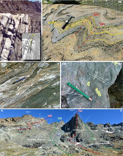
In the field, the most evident deformation phase is represented by the D2, which developed F2 isoclinal folds associated with S2 greenschist facies axial plane foliation ((a,b)). L2 stretching lineations are parallel to the E-W oriented A2 fold axes, suggesting pervasive shearing during the D2 phase. Shear bands and asymmetric porphyroclasts indicate a top-to-the-W transport direction ((c)). The evidence of the tectonic boundaries deformed by F2 folds suggested that the different tectonic units were juxtaposed during the D1 or alternatively in the early stages of the D2. In the eclogitic units, the S2 is a composite schistosity progressively developed during the exhumation processes (CitationEllero & Loprieno, 2018), initially characterized by the oriented growth of glaucophane and epidote typical of blueschist facies, then replaced by greenschist assemblages represented by Ca-Amphibole, chlorite, albite and titanite growth along the same schistosity. Instead, in the Broillot Unit, the S2 has developed entirely within greenschist metamorphic facies conditions (CitationEllero & Loprieno, 2018).
The last D3 deformation phase is testified by open to closed F3 folds ((b)) with A3 fold axes parallel to A2 axes and L2 stretching lineations, associated with gently NE or SW S3 dipping axial plane crenulation cleavage ((d)). The superposition between F3 and F2 folds produced type 3 interference pattern of CitationRamsay (Citation1967) ((b)).
The interference pattern between the three deformation phases D1, D2, and D3 is particularly evident in the Miserin lakes area, where the marker is represented by the tectonic contact between Acque Rosse and Bardonney units ((e)).
6. Discussion
During the geological mapping of the Piemonte-Ligurian units outcropping in the Urtier Valley, a lithostratigraphic approach was applied to reconstruct the different units in the field and the large-scale structures. The two Piemonte-Ligurian units recognized in the Urtier Valley can be distinguished not only for their different peak metamorphic conditions, but also for their different stratigraphic features. In fact, while the Broillot Unit retains an almost complete cover sequence associated with its ophiolitic basement, the Bardonney Unit consists of a chaotic complex, without any lithostratigraphic order.
The preserved stratigraphic boundaries in the Broillot Unit succession represent the key for the reconstruction of the regional structures of the nappe pile in Urtier Valley. These boundaries, easily recognizable at the outcrop, can be followed in the field for kilometers allowing the recognition normal or reverse flanks of the fold structures taking into account of the normal or reverse polarity of stratigraphic succession. This approach led to the reconstruction of a nappe pile proposed in CitationEllero and Loprieno (2018), characterized by a geometric order of superposition between Piemonte-Ligurian units different from previously proposed models for the study area and in general for the south of Aosta Valley (e.g. CitationBallèvre et al., Citation1986; CitationBattiston et al., Citation1984; CitationBeltrando et al., Citation2008). The Tour Ponton structure at the map scale summarizes the effective geometrical order of the nappe pile (, Main Map). The opposite stratigraphic polarity of Broillot Unit succession, north and south of the Gneiss Minuti Complex of Tour Ponton Unit, testify reverse and normal limbs of a F2 synform. Retrodeforming this F2 fold, a geometrical stack characterized from top to bottom by Tour Ponton Unit, Bardonney Unit and Broillot Unit is shown. The structural stack thus obtained differs from what is usually proposed for the Western Alps, because it is characterized by the eclogite facies units (Tour Ponton and Bardonney units) onto the blueschists facies unit (Broillot Unit). This apparently anomalous stack order, was explained by a complex multistage D2 exhumation phase, in which, the tectonic contacts, developed in the early stages, were folded during the latest D2 stages (CitationEllero & Loprieno, 2018). In the proposed model, the Tour Ponton structure corresponds to an overturned limb of a F2 regional isoclinal fold involving eclogitic units in the core of blueschist units, whose normal limb crops out in the northern Aosta Valley (Figure 16 in CitationEllero & Loprieno, 2018).
Considering the preserved stratigraphic succession of the Broillot Unit as an effective marker for the reconstruction of the structural stack geometries, it is possible to observe how, the anomalous stack order described for the Tour Ponton structure, characterizes the entire study area. In this regard, particularly significant is the finding of slivers of typical Broillot metasedimentary succession, with the association of prasinite, quartzite and calcschists, tectonically above the Gran Paradiso Unit (, Main Map). The direct superposition of the blueschists facies Broillot Unit above the eclogite facies Gran Paradiso Unit was interpreted as a normal fault-type contact, originated during the early stages of the D2 exhumation phase (CitationEllero & Loprieno, 2018).
The structural stack created during the exhumation phases, was subsequently refolded by the D3 deformation phase that was correlated with the D3 nappe refolding phase of CitationBucher et al. (Citation2003, Citation2004) (CitationEllero & Loprieno, 2018).
Finally, this regional structure was dislocated by the Late Oligocene-Neogene Aosta-Ranzola normal fault system (ARL in (c)) (CitationBistacchi et al., Citation2001), with the inverted limb of the regional fold outcropping south of Aosta Valley.
7. Conclusions
Detailed field mapping in the Urtier Valley was performed, leading to a new 1:12.500 scaled geological map, accompanied by geological cross-sections. Geological mapping was accomplished by applying an unusual approach for a highly deformed and metamorphic environment such as the Western Alps. The two tectonics units belonging to the Piemonte – Ligurian oceanic domain were in fact distinguished on the basis of their respective lithostratigraphic characters. The two oceanic units recognized in the study area, named Broillot and Bardonney units, can be correlated respectively to the blueschist facies Combin Unit and to the eclogite facies Zermatt-Saas Unit, traditionally distinguished inside the Piemonte – Ligurian oceanic domain of the Western Alps. The Broillot Unit is characterized by a well-preserved stratigraphic succession which can be interpreted as the metamorphic equivalent of the pelagic deposits described for the Internal Liguride units in the Northern Apennines. Conversely, the Bardonney Unit shows the characteristics of a chaotic complex, without any stratigraphic order. The preserved stratigraphic contacts observed in the Broillot Unit have been used as markers for the reconstruction of the structures at the map scale, thanks to their evidence and continuity in the field. In addition, the stratigraphic polarity allowed to clearly recognize normal or reverse limbs of map scale folds. This study highlighted a structural stack characterized by eclogite facies units at the top of the nappe pile. This structural setting can be explained assuming a regional scale fold structure with eclogite facies unit at the core, with the inverted and normal limbs outcropping respectively south and north of Aosta Valley.
Geological and structural mapping even of little areas, proved to be a necessary tool for a robust geodynamic reconstruction at regional scale.
Moreover, this study showed that, also in a severely metamorphosed and deformed environment, the lithostratigraphic approach can be the most valuable tool to reconstruct the nappe stack.
Software
The map database has been implemented in QGIS environment (QGIS 3.10). The final map layout was assemblated using Adobe Illustrator. Finally, we have used Adobe Illustrator and Adobe Photoshop for figures and photo assemblages.
Geolocation information
The Main Map is located in the Urtier Valley, Aosta Valley Region, Italy. It extends between latitude N 45°37′44.9652″ and N 45°34′32.682″ and longitude E 7°21′43.83″ and E 7°30′47.4552″.
TJOM_1986156_supplemental material
Download PDF (95.5 MB)Acknowledgements
The Authors wish to thank Gianni Balestro, Michele Locatelli and Nicholas Scarle for their constructive revision. We are grateful to Bruno Bassano of the Gran Paradiso National Park for permission to collect samples in the protected area. Many thanks to our friend Beppe Ottria for many suggestions and his preliminary review. This study was made possible thanks to the work done over the years with passion by Andrea ‘Peo’ Loprieno who loved the Urtier Valley as a second home. Andrea met his untimely end in 2018. This work is dedicated to him.
Disclosure statement
No potential conflict of interest was reported by the author(s).
Data availability statement
The data that support the findings of this study are available from the corresponding author upon reasonable request.
Additional information
Funding
References
- Amato, J. M., Johnson, C. M., Baumgartner, L., & Beard, B. L. (1999). Rapid exhumation of the Zermatt-Saas ophiolite deduced from high-precision SmNd and RbSr geochronology. Earth and Planetary Science Letters, 171(3), 425–438. https://doi.org/https://doi.org/10.1016/S0012-821X(99)00161-2
- Argand, E. (1911). Les nappes des recouvrement des Alpes Pennines et leur prolongements structuraux. Mat. Carte géol. Suisse, 31, 1–26.
- Argand, E. (1916). Sur l'arc des Alpes Occidentales (pp. 146–151). XIV: Eclogae Geologicae Helvetiae.
- Balestro, G., Festa, A., & Dilek, Y. (2019). Structural architecture of the Western Alpine Ophiolites, and the Jurassic seafloor spreading tectonics of the Alpine Tethys. Journal of the Geological Society, 176(5), 913–930. https://doi.org/https://doi.org/10.1144/jgs2018-099
- Ballèvre, M. (1988). Collision continentale et chemins P–T: L’unité pennique du Grand Paradis (Alpes occidentales). Mémoires et Documents du Centre Armoricain d’Etudes Structurales des Socles, 19, 352.
- Ballèvre, M., Kienast, J. R., & Vuichard, J. P. (1986). La ‘‘nappe de la Dent Blanche’’ (Alpes occidentales): deux unites austroalpines indépéndantes. Eclogae Geologicae Helvetiae, 79, 57–74.
- Ballèvre, M., & Merle, O. (1993). The Combin fault: Compressional reactivation of a late cretaceous–early Tertiary detachment fault in the Western Alps. Schweizerische Mineralogische und Petrographische Mitteilungen, 73, 205–227.
- Battiston, P., Benciolini, L., Dal Piaz, G. V., De Vecchi, G., Marchi, G., Martin, S., Polino, R., & Tartarotti, P. (1984). Geologia di una traversa dal Gran Paradiso alla zona Sesia-Lanzo in alta Val Soana, Piemonte. Memorie Società Geologica Italiana, 29, 209–232.
- Bearth, P. (1967). Die Ophiolite der Zone von Zermatt-Saas Fee. Beiträge zur geologischen Karte der Schweiz, 132, 1–30.
- Beltrando, M., Lister, G. S., Hermann, J., Forster, M., & Compagnoni, R. (2008). Deformation mode switches in the Penninic units of the Urtier Valley (Western Alps): evidence for a dynamic orogen. Journal of Structural Geology, 30(2), 194–219. https://doi.org/https://doi.org/10.1016/j.jsg.2007.10.008
- Beltrando, M., Manatschal, G., Mohn, G., Dal Piaz, G. V., Brovarone, A. V., & Masini, E. (2014). Recognizing remnants of magma-poor rifted margins in high-pressure orogenic belts: The Alpine case study. Earth-Science Reviews, 131, 88–115. https://doi.org/https://doi.org/10.1016/j.earscirev.2014.01.001
- Bertrand, J.-M. (1968). Etude structurale du versant occidental du Massif du Grand Paradis (Alpes Graies). Géologie Alpine, 44, 57–87.
- Bigi, G., Cosentino, D., Parotto, M., Sartori, R., & Scandone, P. (1990). Structural model of Italy 1:500.000, sheet 1, S.El.CA., Firenze.
- Bistacchi, A., Dal Piaz, G. V., Massironi, M., Zattin, M., & Balestrieri, M. L. (2001). The Aosta–Ranzola extensional fault system and oligocene–present evolution of the Austroalpine–Penninic wedge in the northwestern Alps. International Journal of Earth Sciences, 90(3), 654–667. https://doi.org/https://doi.org/10.1007/s005310000178
- Bousquet, R. (2008). Metamorphic heterogeneities within a single HP unit: Overprint effect or metamorphic mix? Lithos, 103(1-2), 46–69. https://doi.org/https://doi.org/10.1016/j.lithos.2007.09.010
- Brouwer, F. M., Vissers, R. L. M., & Lamb, W. M. (2002). Structure and metamorphism of the Gran Paradiso massif, Western Alps, Italy. Contributions to Mineralogy and Petrology, 143(4), 450–470. https://doi.org/https://doi.org/10.1007/s00410-002-0357-6
- Bucher, S., Schmid, S. M., Bousquet, R., & Fügenschuh, B. (2003). Late-stage deformation in a collisional orogen (Western Alps): Nappe refolding, back-thrusting or normal faulting? Terra Nova, 15(2), 109–117. https://doi.org/https://doi.org/10.1046/j.1365-3121.2003.00470.x
- Bucher, S., Ulardic, C., Bousquet, R., Ceriani, S., Fügenschuh, B., Gouffon, Y., & Schmid, S. M. (2004). Tectonic evolution of the Briançonnais units along a transect (ECORS-CROP) through the Italian–French Western Alps. Eclogae Geologicae Helvetiae, 97(3), 321–345. https://doi.org/https://doi.org/10.1007/s00015-004-1139-0
- Burroni, A., Levi, N., Marroni, M., & Pandolfi, L. (2003). Lithostratigraphy and structure of the Lago Nero Unit (Chenaillet Massif, Western Alps): comparison with Internal Liguride Units of Northern Apennines. Ofioliti, 28, 1–11.
- Butler, J. P., Beaumont, C., & Jamieson, R. A. (2013). The Alps 1: A working geodynamic model for burial and exhumation of (ultra)high-pressure rocks in Alpine-type orogens. Earth and Planetary Science Letters, 377–378, 114–131. https://doi.org/https://doi.org/10.1016/j.epsl.2013.06.039
- Compagnoni, R., Elter, G., & Lombardo, B. (1974). Eterogeneità stratigrafica del complesso degli “Gneiss Minuti” nel massiccio cristallino del Gran Paradiso. Memorie della Società geologica Italiana, 13, 227–239.
- Dal Piaz, G. V. (1999). The Austroalpine-Piedmont nappe stack and the puzzle of Alpine Tethys. Memorie di Scienze Geologiche, 51, 155–176.
- Dal Piaz, G. V. (2001). Geology of the Monte Rosa massif: Historical review and personal comments. Schweizerische Mineralogische und Petrographische Mitteilungen, 81, 275–303.
- Dal Piaz, G. V., Bistacchi, A., & Massironi, M. (2003). Geological outline of the Alps. Episodes, 26(3), 175–180. https://doi.org/https://doi.org/10.18814/epiiugs/2003/v26i3/004
- Dal Piaz, G. V., Cortiana, G., Del Mora, A., Martin, S., Pennacchioni, G., & Tartarotti, P. (2001). Tertiary age and paleostructural inferences of the eclogitic imprint in the Austroalpine outliers and Zermatt-Saas ophiolite, western Alps. International Journal of Earth Sciences, 90(3), 668–684. https://doi.org/https://doi.org/10.1007/s005310000177
- Dal Piaz, G. V., Gianotti, F., Monopoli, B., Pennacchioni, G., Tartarotti, P., & Schiavo, A. (2008). Carta Geologica d’Italia alla scala 1:50.000. Foglio 091 Chatillon. Servizio Geologico d’Italia, Roma.
- Dal Piaz, G. V., Lombardo, B., & Gosso, G. (1983). Metamorphic evolution of the Mt. Emilius klippe, Dent Blanche nappe, Western Alps. American Journal of Science, 283A, 438–458.
- Dal Piaz, G. V., & Nervo, R. (1971). Il lembo di ricoprimento del Glacier-Rafray (Dent Blanche s.l.). Bollettino della Società Geologica Italiana, 90, 401–414.
- Dal Piaz, G. V., Nervo, R., & Polino, R. (1979). Carta geologica del lembo del Glacier-Rafray (Dent Blanche s.l.) e note illustrative. Centro studi problemi orogeno Alpi occidentali, CNR Torino, 2, pp. 24.
- Decandia, F. A., & Elter, P. (1969). Riflessioni sul problema delle ofioliti nell’Appennino settentrionale. Memorie della Società Toscana di Scienze Naturali, 76, 1.
- Decandia, F. A., & Elter, P. (1972). La zona ofiolitifera del Bracco nel settore compreso tra Levanto e la Val Graveglia (Appennino Ligure). Memorie della Società Geologica Italiana, 11, 503–530.
- Deville, E., Fudral, S., Lagabrielle, Y., Marthaler, M., & Sartori, M. (1992). From oceanic closure to continental collision: A synthesis of the “Schistes lustrés” metamorphic complex of the Western Alps. Geological Society of America Bulletin, 104(2), 127–139. https://doi.org/https://doi.org/10.1130/0016-7606(1992)104<0127:FOCTCC>2.3.CO;2
- Dewey, J. F., Helman, M. L., Turco, E., Hutton, D. H. W., & Knott, S. D. (1989). Kinematics of the western Mediterranean. In M. P. Coward, D. Dietrich, & R. G. Park (Eds.), Alpine tectonics (pp. 265–283). Geological Society, London, Special Publications, 45.
- Ellero, A. (1994). Geologia delle unità ofiolitiche nel Vallone dell’Urtier, Cogne – Alpi Occidentali [Unpublished master's thesis]. University of Pisa.
- Ellero, A., & Loprieno, A. (2014). Ophiolitic units of the Northern Apennines as a tool to unravel schistes lustres stratigraphy of the Western Alps and their geodynamic context: the Urtier Valley example, Cogne, Aosta Valley. In I rapporti tra l’Appennino Settentrionale e le Alpi Occidentali: stato dell’arte a 50 anni dalla “Ruga del Bracco” – Convegno in memoria di Piero Elter, 22–23.
- Ellero, A., & Loprieno, A. (2018). Nappe stack of Piemonte–Ligurian units south of Aosta Valley: New evidence from Urtier Valley (Western Alps). Geological Journal, 53(5), 1665–1684. https://doi.org/https://doi.org/10.1002/gj.2984
- Elter, G. (1971). Schistes lustrés et ophiolites de la zone piémontaise entre Orco et Doire Baltée (Alpes Graies). Hypothèses sur l’origine des ophiolites. Géologie Alpine, 47, 147–169.
- Elter, G. (1972). Contribution a la connaissance du Briançonnais interne et de la bordure piémontaise dans les Alpes Graies nord-orientales et considerations sur les rapports entre les zones du Briançonnais et des Schistes Lustrés. Memorie degli Istituti di Geologia e Mineralogia dell'Università di Padova, 28, 19.
- Elter, G. (1987). Carte géologique de la Vallée d'Aoste, échelle 1:100.000. CNR e Centro di studio sui problemi dell'orogeno delle Alpi occidentali, Torino. S.EL.CA., Firenze.
- Elter, P. (1975). L’ensemble ligure. Bulletin de la Société Géologique de France, 17(6), 984–997. https://doi.org/https://doi.org/10.2113/gssgfbull.S7-XVII.6.984
- Fassmer, K., Obermüller, G., Nagel, T. J., Kirst, F., Froitzheim, N., Sandmann, S., Miladinova, I., Fonseca, R. O. C., & Münker, C. (2016). High-pressure metamorphic age and significance of eclogite-facies continental fragments associated with oceanic lithosphere in the Western Alps (Etirol-Levaz Slice, Valtournenche, Italy). Lithos, 252-253, 145–159. https://doi.org/https://doi.org/10.1016/j.lithos.2016.02.019
- Festa, A., Balestro, G., Dilek, Y., & Tartarotti, P. (2015). A Jurassic oceanic core complex in the high-pressure Monviso ophiolite (western Alps, NW Italy). Lithosphere, 7(6), 646–652. https://doi.org/https://doi.org/10.1130/L458.1
- Inger, S., Ramsbotham, W., Cliff, R. A., & Rex, D. C. (1996). Metamorphic evolution of the Sesia-Lanzo zone, Western Alps: Time constraints from multi-system geochronology. Contributions to Mineralogy and Petrology, 126(1-2), 152–168. https://doi.org/https://doi.org/10.1007/s004100050241
- Lafay, R., Baumgartner, L. P., Schwartz, S., Picazo, S., Montes-Hernandez, G., & Vennemann, T. (2017). Petrologic and stable isotopic studies of a fossil hydrothermal system in ultramafic environment (Chenaillet ophicalcites,Western Alps, France): Processes of carbonate cementation. Lithos, 294-295, 319–338. https://doi.org/https://doi.org/10.1016/j.lithos.2017.10.006
- Lagabrielle, Y., Brovarone, A. V., & Ildefonse, B. (2015). Fossil oceanic core complexes recognized in the blueschist metaophiolites of Western Alps and Corsica. Earth-Science Reviews, 141, 1–26. https://doi.org/https://doi.org/10.1016/j.earscirev.2014.11.004
- Lagabrielle, Y., & Polino, R. (1988). Un schéma structural du domaine des Schistes lustrés ophiolitifères au nord-ouest du massif du Mont Viso (Alpes sud-occidentales) et ses implications. Comptes rendus de l'Académie des Sciences, 306(Série II), 921–928.
- Lapen, T. J., Johnson, C. M., Baumgartner, L. P., Dal Piaz, G. V., Skora, S., & Beard, B. L. (2006). Coupling of oceanic and continental crust during eocene eclogite-facies metamorphism: Evidence from the Monte Rosa nappe, western Alps. Contributions to Mineralogy and Petrology, 153(2), 139–157. https://doi.org/https://doi.org/10.1007/s00410-006-0144-x
- Lapen, T. J., Johnson, C. M., Baumgartner, L. P., Mahlen, N. J., Beard, B. L., & Amato, J. M. (2003). Burial rates during prograde metamorphism of an ultra-high-pressure terrane: An example from Lago di cignana, Western Alps, Italy. Earth and Planetary Science Letters, 215(1-2), 57–72. https://doi.org/https://doi.org/10.1016/S0012-821X(03)00455-2
- Le Bayon, B., & Ballèvre, M. (2006). Deformation history of a subducted continental crust (Gran Paradiso, Western Alps): continuing crustal shortening during exhumation. Journal of Structural Geology, 28(5), 793–815. https://doi.org/https://doi.org/10.1016/j.jsg.2006.02.009
- Lemoine, M. (1971). Données nouvelles sur la série du Gondran près de Briancon (Alpes Cottiens). Réflexions sur les problèmes stratigraphiques et paléogeographiques de la zone piémontaise. Géologie Alpine, 47, 181–201.
- Lemoine, M. (1980). Serpentinites, gabbros and ophicalcites in the Piemont-Ligurian domain of the Western Alps: possible indicators of oceanic fracture zones and of associated serpentinite protrusions in the Jurassic-Cretaceous Tethys. Archives Des Sciences / Editees Par La Societe De Physique Et D'histoire Naturelle De Geneve, 33, 103–115.
- Liati, A., Froitzheim, N., & Fanning, C. M. (2005). Jurassic ophiolites within the Valais domain of the Western and Central Alps: Geochronological evidence for re-rifting of oceanic crust. Contributions to Mineralogy and Petrology, 149(4), 446–461. https://doi.org/https://doi.org/10.1007/s00410-005-0658-7
- Liati, A., Gebauer, D., & Froitzheim, N. (2002). Late Cretaceous basic oceanic magmatism in the Valais ocean, Western and Central Alps: geochronological evidence and paleogeographic implications. Annual meeting of the Swiss academy of natural sciences, Abstract volume, Davos, pp. 26–27.
- Loprieno, A. (1994). Studio geologico del Vallone dell’Urtier, Cogne – Alpi Occidentali [Unpublished master's thesis]. University of Pisa.
- Loprieno, A., Ellero, A., Elter, P., & Molli, G. (2009). Structural geometries and tectonic evolution of ophiolite and continental units in the Urtier Valley, Cogne (Western Alps). 9th Alpine Workshop “AlpShop 2009”, September 2009, Cogne, Italy.
- Michard, A., Goffé, B., Chopin, C., & Henry, C. (1996). Did the Western Alps develop through an Oman-type stage? The geotectonic setting of high-pressure metamorphism in two contrasting Tethyan transects. Eclogae geologicae Helvetiae, 89, 43–80.
- Nervo, R., & Polino, R. (1976). Un lembo di cristallino Dent Blanche alla Torre Ponton (Valle d’Aosta). Bollettino- Societa Geologica Italiana, 95, 647–657.
- Paganelli, F., Compagnoni, R., Nervo, R., & Tallone, S. (1995). Il lembo Austroalpino di Eaux Rousses e le sue relazioni con la Zona Ofiolitica Piemontese dell’alta Valle di Cogne, Valle d’Aosta meridionale. In R. Polino & R. Sacchi (Eds.), Atti convegno Alpi-Appennino, Peveragno 1994. Accademia Nazionale delle Scienze detta dei XL, Scritti e Documenti (Vol. 14, pp. 335–348).
- Pennacchioni, G. (1991). Evoluzione strutturale del M. Emilius (Austroalpino, Alpi occidentali). Rendiconti della Società Geologica Italiana, 14, 97–100.
- Pennacchioni, G. (1996). Progressive eclogitization under fluid-present conditions of pre-Alpine mafic granulites in the Austroalpine Mt. Emilius klippe (Italian Western Alps). Journal of Structural Geology, 18(5), 549–561. https://doi.org/https://doi.org/10.1016/S0191-8141(96)80023-X
- Pleuger, J., Roller, S., Walter, J. M., Jansen, E., & Froitzheim, N. (2007). Structural evolution of the contact between two Penninic nappes (Zermatt-Saas zone and Combin zone, Western Alps) and implications for the exhumation mechanism and palaeogeography. International Journal of Earth Sciences, 96(2), 229–252. https://doi.org/https://doi.org/10.1007/s00531-006-0106-6
- Pognante, U. (1989). Lawsonite, blueschist and eclogite formation in the southern Sesia Zone (western Alps, Italy). European Journal of Mineralogy, 1(1), 89–104. https://doi.org/https://doi.org/10.1127/ejm/01/1/0089
- Polino, R., & Lemoine, M. (1984). Détritisme mixte d’origine continentale et océanique dans les sediments jurassico-crétacés supra-ophiolitiques de la Téthys ligure: la série du Lago Nero (Alpes Occidentales franco-italiennes). Comptes rendus de l'Académie des Sciences, 298, 359–364.
- Radulescu, I. G., Rubatto, D., Gregory, C., & Compagnoni, R. (2009). The age of HP metamorphism in the Gran Paradiso Massif, Western Alps: A petrological and geochronological study of “silvery micaschists”. Lithos, 110(1-4), 95–108. https://doi.org/https://doi.org/10.1016/j.lithos.2008.12.008
- Ramsay, J. C. (1967). Folding and fracturing of rocks. McGraw-Hill.
- Ramsbotham, W., Inger, S., Cliff, B., Rex, D., & Barnicoat, A. (1994). Time constraints on the metamorphic and structural evolution of the southern Sesia-Lanzo zone, Western Italian Alps. Mineralogical Magazine, 58A(2), 758–759. https://doi.org/https://doi.org/10.1180/minmag.1994.58A.2.131
- Rosenbaum, G., & Lister, G. S. (2005). The Western Alps from the Jurassic to Oligocene: Spatio-temporal constraints and evolutionary reconstructions. Earth-Science Reviews, 69(3-4), 281–306. https://doi.org/https://doi.org/10.1016/j.earscirev.2004.10.001
- Rubatto, D., Gebauer, D., & Compagnoni, R. (1999). Dating of eclogite-facies zircons: The age of Alpine metamorphism in the Sesia-Lanzo zone (western Alps). Earth and Planetary Science Letters, 167(3-4), 141–158. https://doi.org/https://doi.org/10.1016/S0012-821X(99)00031-X
- Schmid, S. M., Fügenschuh, B., Kissling, E., & Schuster, R. (2004). Tectonic map and overall architecture of the Alpine orogen. Eclogae Geologicae Helvetiae, 97(1), 93–117. https://doi.org/https://doi.org/10.1007/s00015-004-1113-x
- Schmid, S. M., & Kissling, E. (2000). The arc of the Western Alps in the light of geophysical data on deep crustal structure. Tectonics, 19(1), 62–85. https://doi.org/https://doi.org/10.1029/1999TC900057
- Tartarotti, P., Festa, A., Benciolini, L., & Balestro, G. (2017b). Record of Jurassic mass transport processes through the orogenic cycle: Understanding chaotic rock units in the high-pressure Zermatt-Saas ophiolite (Western Alps). Lithosphere, 9(3), 399–407. https://doi.org/https://doi.org/10.1130/L605.1
- Tartarotti, P., Guerini, S., Rotondo, F., Festa, A., Balestro, G., Bebout, G. E., Cannaò, E., Epstein, G. S., & Scambelluri, M. (2019a). Superposed sedimentary and tectonic block-in-matrix fabrics in a subducted serpentinite mélange (high-pressure Zermatt Saas Ophiolite, Western Alps). Geosciences, 9(8), 358. https://doi.org/https://doi.org/10.3390/geosciences9080358
- Tartarotti, P., Martin, S., Meyzen, C. M., Benciolini, L., & Toffolo, L. (2019b). Structural evolution and metasomatism of subducted metaophiolites in the Northwestern Alps. Tectonics, 38(12), 4185–4206. https://doi.org/https://doi.org/10.1029/2019TC005626
- Tartarotti, P., Martin, S., Monopoli, B., Benciolini, L., Schiavo, A., Campana, R., & Vigni, I. (2017a). Geology of the Saint-Marcel valley metaophiolites (Northwestern Alps, Italy). Journal of Maps, 13(2), 707–717. https://doi.org/https://doi.org/10.1080/17445647.2017.1355853
- Thöni, M. (1999). A review of geochronological data from the eastern Alps. Schweizerische Mineralogische und Petrographische Mitteilungen, 79, 209–230.
- Villa, I. M., Bucher, S., Bousquet, R., Kleinhanns, I. C., & Schmid, S. M. (2014). Dating polygenic metamorphic assemblages along a transect across the Western Alps. Journal of Petrology, 55(4), 803–830. https://doi.org/https://doi.org/10.1093/petrology/egu007