
ABSTRACT
We present a geomorphic map of the glacial landforms associated with the Golfo Corcovado ice lobe in northwestern Patagonia. Built upon prior studies, our map elaborates on the central and southern sectors of Isla Grande de Chiloé and neighboring islands. Through a combination of remote sensing techniques and exhaustive fieldwork, we identified a suite of ice-marginal, subglacial, and glaciofluvial features created by the Golfo Corcovado ice lobe during four maxima within the last glacial cycle, in none of which the ice-front reached the Pacific coast of Isla Grande de Chiloé. Our mapping builds a foundation and provides insights for future interdisciplinary research on the Late Quaternary sequence of glacial and paleoclimatic events in this key sector of northwestern Patagonia.
1. Introduction
Isla Grande de Chiloé (IGC) constitutes the largest island of the Chilotan Archipelago, which is composed by ∼40 islands located in the Chilotan Inner Sea, just south of the Chilean Lake District (CLD) and west of Chiloé Continental, in northwestern Patagonia (40°S–44°S; ). This region has been central in the study of former glacial fluctuations and paleoclimatic conditions in the middle latitudes of the southern hemisphere (e.g. CitationDenton et al., Citation1999; CitationHeusser, 1990; CitationLowell et al., Citation1995; CitationMoreno et al., Citation2015; CitationVillagrán, Citation1985; CitationVillagrán, 1988).
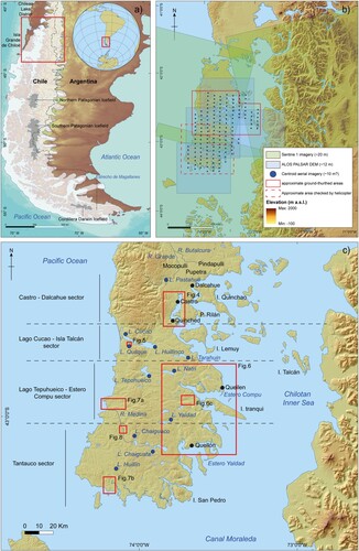
Figure 1. (a) Location of the study area in southern South America. Former limit of the Patagonian Ice Sheet according to CitationDavies et al. (Citation2020) is outlined as a white polygon. Present Patagonian Ice Fields are depicted in grey. (b) Overview of the Chilean Lake District and the Chilotan archipelago showing the coverage of used aerial photographs (dark blue dots: centroids of GEOTEC images) and satellite imagery (light green boxes: Sentinel 1 imagery; blue light boxes: ALOS PALSAR digital elevation model). Field-checking areas (solid red line: inspected on the ground; dashed red line: helicopter inspection). (c) Digital elevation model of Isla Grande de Chiloé region highlighting the main sites of the study area.
During the last ice age, locally known as the Llanquihue glaciation (CitationHeusser, Citation1974), the region was covered by multiple piedmont glacier lobes that extended from Cordillera de los Andes (; CitationDavies et al., Citation2020) which produced a suite of well-preserved glacial landforms and sedimentary deposits. Previous studies have reconstructed the glacial history of CLD during the Last Glacial Maximum (LGM: 35–18 ka, ka = 1000 calibrated years before present) by mapping the extent of glacial landforms, particularly between Lago Ranco and Seno Reloncaví (e.g. CitationDenton et al., Citation1999, Citation1976; CitationLaugénie, Citation1982; CitationLowell et al., Citation1995; CitationMercer, Citation1972; CitationPorter, Citation1981; ). Mapping efforts in the Chilotan archipelago have focused on the central-northern half of IGC, with fragmentary work on its southern third and some islands to the east (CitationAndersen et al., Citation1999; CitationGarcía, Citation2012; ).
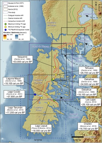
Figure 2. ALOS PALSAR digital elevation model presenting the approximate extent of the major glacial limits in the Chilean Lake District and Isla Grande de Chiloé according to CitationAndersen et al. (Citation1999) and CitationGarcía (Citation2012). The GEBCO 2019 bathymetry of the Chilotan Inner Sea is also shown. Most constraining radiocarbon ages (CitationDenton et al., Citation1999; CitationGarcía, Citation2012; CitationMoreno et al., Citation2015) and recent Bayesian-modelled age based on composite 14C, 10Be and infrared stimulated luminescence (CitationGarcía et al., Citation2021) of the Golfo Corovado ice lobe activity. Green dots indicate close maximum-limiting 14C ages for glacial advances. Yellow dots represent close minimum-limiting 14C for glacial advances. Dark blue dot points the deposition age of the upper Lago Cucao outwash terrace. Radiocarbon ages have been recalculated using the calibration curve from CitationHogg et al. (Citation2020). From north to south, black dashed arrows indicate the inferred ice flow of the Lago Llanquihue, Seno Reloncaví, Golfo Ancud and Golfo Corcovado ice lobes.
Our study seeks to fill the gap in glacial geomorphic and stratigraphic studies in the central and southern sectors of IGC and adjoining archipelago. This contribution is intended as an initial effort to expand our knowledge into a virtually unmapped sector, build a geomorphic framework integrating new sectors with previous site- or sector-specific studies, and laying the foundations to unravel the structure and timing of local glacial fluctuations during the last glacial cycle.
2. Previous work
The earliest sketch of former glacier limits in IGC was published by CitationCaldenius (Citation1932). Subsequently, CitationHeusser and Flint (Citation1977) mapped the landforms-sedimentary associations in glacial drift packages along the northern and central sectors of IGC (). They distinguished three glacial limits based on surface morphology and weathering criteria, which they named San Antonio, Intermediate, and Llanquihue drifts, from outermost to innermost. These glacial limits were correlated to the Colegual, Casma, and Llanquihue drifts (), previously identified by CitationMercer (Citation1972, Citation1976) in the CLD area. Within the latter, and several years later, CitationPorter (Citation1981) defined and mapped four glacial drifts in the Lago Llanquihue area, he termed Caracol, Río Llico, Santa María, and Llanquihue, from outermost to innermost ().
Table 1. Stratigraphic names of the glacial drift hosted in the Chilean Lake District and Isla Grande de Chiloé according to CitationMercer (Citation1972, Citation1976), CitationHeusser and Flint (Citation1977), CitationPorter (Citation1981) and CitationDenton et al. (Citation1999) Golfo Corcovado ice lobe drift sequence labeled by CitationMercer (Citation1972, Citation1976) and CitationDenton et al. (Citation1999).
CitationAndersen et al. (Citation1995, Citation1999) published the first comprehensive geomorphic map of northern IGC (), developed in the context of an interdisciplinary effort to reconstruct the glacial, vegetation, and climate history of CLD during the LGM (CitationDenton et al., Citation1999; CitationLowell et al., Citation1995). They identified at least two glacial drifts, composed by nested moraine ridges they termed Casma/Colegual and Llanquihue drifts, from outermost to innermost (). More recently, CitationGarcía (Citation2012) mapped the glacial landforms of central IGC (), which he tentatively correlated with the Santa María and Llanquihue drifts ().
The initial glacial chronologies from the CLD and IGC relied on relative dating techniques, including morphostratigraphy and weathering rinds (e.g. CitationHeusser & Flint, Citation1977), followed by a generation of studies that benefited from the advent of the radiocarbon dating technique (e.g. CitationHeusser, 1990; CitationMercer, Citation1972; CitationPorter, Citation1981). Subsequently, CitationLowell et al. (Citation1995) and CitationDenton et al. (Citation1999) developed a glacial chronology based on an extensive radiocarbon-dating effort based on multiple minimum and maximum bracketing dates obtained from numerous stratigraphic sections and sediment cores from lakes and bogs associated to the Llanquihue drift. They concluded that ice lobes in the CLD achieved maxima during the last glacial cycle at ∼33.9, ∼30.9, ∼27.0, ∼26.2 and ∼18 ka (CitationMoreno et al., Citation2015). In IGC they show that the Golfo Corcovado ice lobe advanced to the outermost Llanquihue moraine prior to ∼53.0 ka (; CitationDenton et al., Citation1999; CitationHeusser et al., Citation1999), predating the LGM. More recently, CitationGarcía et al. (Citation2021) used a combination of radiocarbon, infrared stimulated luminescence and 10Be depth profiles to conclude that the outermost Llanquihue glacial limit of the Golfo Corcovado ice lobe was formed at ∼57.8 ka, in agreement with previous findings. Subsequent ice advances occurred prior to ∼34.5 ka, after ∼26.7 ka, and shortly after ∼18.1 ka (; CitationDenton et al., Citation1999; CitationHeusser, 1990). They suggested that the final advance of the Golfo Corcovado ice lobe was the most extensive event of the LGM, contrasting with the behavior of ice lobes in the CLD (CitationDenton et al., Citation1999). The westernmost extent of the Golfo Corcovado ice lobe in the southern third of IGC, however, was unaddressed by these studies. The demise of the Golfo Corcovado ice lobe is constrained by basal radiocarbon dates from multiple lakes and bogs inboard or atop the innermost Llanquihue moraine yielding close minimum-limiting ages of ∼17.8 ka. Radiocarbon dates for the onset of ice-free conditions in Chiloé continental of ∼16.7 ka (; CitationMoreno et al., Citation2015) indicate sustained glacier recession across ∼100 km eastward through the Chilotan Inner Sea within ∼1000 years or less.
3. Setting
The Chilotan archipelago spans from ∼41.8° to ∼43.5°S in the Pacific shore of southern Chile. The western sector of IGC is dominated by Cordillera de la Costa (CC) running N-SE. Two topographic gaps corresponding with the Canal de Cachao and Lago Huillinco-Cucao basin divide the range into Cordillera Piuchén (∼900 m a.s.l.) in northern IGC, and Cordillera Pirulil in central-southern IGC. The interior-eastern sector of IGC is characterized by a flat to smooth hilly topography extending eastwards to the inner sea ((c)).
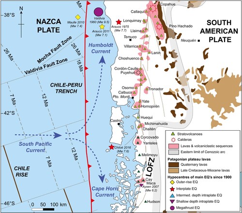
The CC consists of Paleozoic metamorphic and Miocene sedimentary rocks, which limit with Quaternary glacial, glaciolacustrine, and glaciofluvial deposits toward the interior and eastern sectors of IGC (CitationSERNAGEOMIN, Citation2003). The tectonic setting is dominated by the subduction of the Nazca Plate under the South American Plate and the Liquiñe-Ofqui Fault Zone in the continent, accounting for several stratovolcanoes located ≥70 km east of IGC. These have produced numerous tephra layers interbedded within local soil sequences in the Chilotan archipelago, Chiloé continental, and east of the Andean divide (CitationAlloway et al., Citation2017a, Citation2017b, Citation2018) and seismic activity, such as the recent (AD 2016) Mw 7.6 earthquake that occurred offshore south of Tantauco (CitationRuiz & Madariaga, Citation2018; ).
Figure 3. Schematic map showing main oceanographic and tectonic features in the study area. Offshore, the South Pacific current splits into the Humboldt current to the north and the Cape Horn current to the south broadly at the latitude of the Chilotan Archipelago (CitationStrub et al., Citation2019). In the continent, the location of some of the volcanoes and larger caldera systems in the Southern Volcanic Zone (∼33–46°S) of South America (modified from CitationStern et al., Citation2007). The grey shaded line indicates the eastern limit of the Cenozoic arc volcanism, while the dashed north-south line labeled LOFZ is the Liquiñe-Ofqui Fault Zone (CitationCembrano et al., Citation1996, Citation2000). Hypocenters of main earthquakes since 1950, and their spatial classification with respect to the Chile-Perú Trench, are also indicated (CitationRuiz & Madariaga, Citation2018).
The climate of northwestern Patagonia is controlled by the annual cycle of the southern westerly winds, which promotes maximum precipitation during winter and minimum during summer (CitationGarreaud et al., Citation2013). From west to east, meteorological stations distributed across IGC show annual precipitation values that range from ∼2500 to ∼1600 mm and a mean air temperature fluctuating between ∼14°C in summer and ∼7°C in winter (data retrieved from www.explorador.cr2.cl). Satellite data indicate offshore sea surface temperatures ranging between ∼15°C in summer and ∼11°C in winter, whereas the Chilotan Inner Sea follows a similar pattern but slightly colder during the entire year (CitationSaldías et al., Citation2021).
4. Map production
We present a glacial geomorphic map of central and southern IGC (∼42.2°∼43.5°S) that encompasses areas within and beyond previous mapping efforts (; CitationAndersen et al., Citation1999; CitationGarcía, Citation2012; CitationHeusser & Flint, Citation1977). We developed descriptions and interpretations from raw observations, extending our analysis into neighboring islands and sea floor whenever pertinent.
We conducted an initial identification of major glacial landforms ((b)) using aerial photographs (1:70,000) and satellite imagery from Google Earth (2016 Cnes/SPOT, ∼15 m spatial resolution), SENTINEL-2 (∼10 m spatial resolution), and ESRI Imagery (2017, TerraColor, ∼15 m spatial resolution and SPOT, ∼2.5 m spatial resolution). We analyzed minor topographic features using images from the Advanced Land Observation Satellite (ALOS PALSAR, ∼12 m spatial resolution). Submarine landforms were examined with the General Bathymetric Chart of Oceans 2019 (GEBCO 2019, ∼0.6 km/pixel spatial resolution). We ground-truthed the preliminary interpretations based on glacial geomorphologic mapping through field campaigns between 2016 and 2019 ((b)). While the more accessible locations in central IGC and adjacent islands were covered on the ground, the southern sector, corresponding to the Tantauco area, was scouted from a helicopter.
5. Results
We summarized the glacial landforms identified throughout central and southern IGC in , indicating their corresponding: (i) morphological description, (ii) identification criteria, (iii) potential uncertainties, (iv) interpretation, and (v) previous mapping efforts of the individual landforms recognized in IGC.
Table 2. Summary of glacial landforms, identification criteria, uncertainties, and previous mapping of the geomorphology of the Golfo Corcovado ice lobe (adapted from CitationBendle et al., Citation2017; CitationDarvill et al., Citation2014; CitationLeger et al., Citation2020; CitationLovell et al., Citation2012; CitationSoteres et al., Citation2020).
We divided the study area in four sectors ((c)) to facilitate the descriptions, which we present from north to south.
5.1. Castro-Dalcahue sector
This sector extends between Río Butalcura to the mouth of Estero Castro ((c)). To the west, the CC reaches its maximum elevation in IGC (∼900 m.a.s.l.). Plastered against the eastern flank of the range, we recognize a sequence of diffuse ice-contact slopes () accompanied by poorly-defined till deposits running at elevations of ∼370 m a.s.l. Immediately to the east, we identify at least three outwash terraces (), extending from CC to the Pindapulli community, that descend in elevation toward the NW from the Dalcahue-Castro coastline through the Mocopulli-Pupetra sector into the Río Butalcura channel. The lower outwash plain extends for ∼10 km ranging from ∼180 m a.s.l. at its headwaters to ∼100 m a.s.l. at its distal portion, the upper subsidiary outwash terraces reach ∼190 and ∼200 m a.s.l. at their headwaters, respectively.
To the east and south of the outwash plains, the landscape is characterized by irregular morainic topography (; ) extending to the eastern coast of IGC (CitationAndersen et al., Citation1999; CitationGarcía, Citation2012). In this area, we distinguish remnants of nested, and relatively sharp moraine ridges () oriented from NE to SW between Dalcahue and Río Butalcura. These ice-marginal features are partially buried by the outwash plain that mantles the Mocopulli and Pupetra area (Main map).
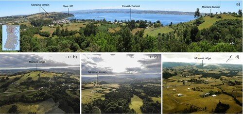
Figure 4. Oblique aerial photographs of the morainal topography and moraine ridge near Castro ((c)).
Another distinctive feature in the east coast of IGC corresponds to a continuous and steep ice-contact slope () that runs between Dalcahue and Castro. At its proximal side, the slope presents an irregular topography with smooth hills accentuated by minor creeks. Numerous stratigraphic exposures in this area reveal a sequence of laminated sands with discrete lenses of silts and clays and occasional dropstones, which we interpret as glaciolacustrine beds. These deposits were first described by CitationHeusser and Flint (Citation1977), who inferred the presence of a proglacial lake during the last deglaciation we name, informally, ice-dammed lake Castro. At the top of this ice-contact slope, we identify moraine ridges and/or the headwaters of the outwash plain terraces discussed above, as well as a mayor channel that dissects the lower outwash (; Main map). This channel starts at ∼100 m a.s.l. east of Dalcahue and presents a sinuous plan flowing northward into the Mocopulli-Pupetra outwash plain and ending in Río Butalcura. This channel, which is currently inactive, likely evacuated meltwater from its respective ice-front or functioned as the spillway of lake Castro during the final phases of the last glaciation (CitationHeusser et al., Citation1995).
To the southeast of the Castro-Dalcahue ice-contact slope, we distinguish a suite of continuous and sharp moraine ridges running N-S in Península Rilán. The interior of the peninsula features an outwash plain that descends northward from an elevation of ∼120 m a.s.l. at its headwater (Main map). Its distal portion shows a tilted sequence of sand and gravel layers capped by horizontal layers of sands and gravels we interpret as the topsets and foresets, respectively, of a Gilbert-type delta (). The paleodelta reaches ∼100 m a.s.l., marking a maximum level for the glacial lake that deposited the glaciolacustrine sediments discussed in the previous paragraph, which most likely discharged through the channel located east of Dalcahue.
We recognize several ice-marginal features further east on Isla Quinchao, including groups of moraine ridges running NW-SE in the island interior, and ice-contact slopes forming its northern shore, where glaciolacustrine beds in natural outcrops are ubiquitous (Main map).
The small islands to the east exhibit irregular morainal topography lacking sharp and laterally continuous ridges that would indicate former ice-front stabilization in the archipelago following withdrawal from the LGM margins.
5.2. Lago Cucao – Isla Talcán sector
From north to south, this sector spans from the southern limit of Península Rilán to Lago Tepuhueico. The most conspicuous topographic feature is a wide valley that crosses CC from east to west, where Lago L. Cucao and Lago L. Huillinco are located ((c)).
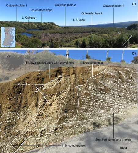
We observe two levels of outwash plains sloping westward, north and south of L. Cucao (). The upper outwash plain ranges between ∼150 and ∼60 m a.s.l. from its headwaters to its distal portion, and the lower between ∼120 and ∼30 m a.s.l., respectively. We recognize moraine remnants partially buried by the upper outwash south of L. Cucao (Main map). A well-defined ice-contact slope immediately west of Lago Quilque () separates both outwash plains. Further evidence supporting our interpretation of this landform comes from a road cut near its culmination revealing a stratigraphy composed by massive sands with gravel lenses in discordant contact with a sequence of horizontal layers of sand and gravels we interpret as a glaciofluvial deposit ((b); CitationTurbek & Lowell, Citation1999).
Figure 5. (a) Overview of the sequence of outwash plains nearby Lago Cucao and ice-contact slope of Lago Quilque ((c)). (b) Detail of a stratigraphic exposure at the culmination of the Lago Quilque ice-contact slope.
Further east of L. Cucao, along its northern shore, we identify a sequence of ice-contact slopes between ∼200 and ∼300 m a.s.l. resting on the eastern slope of CC (Main map). These features can be traced southward to a narrowing located between L. Cucao and L. Huillinco, where we find minor moraine ridges and ice-moulded bedrock outcrops ().
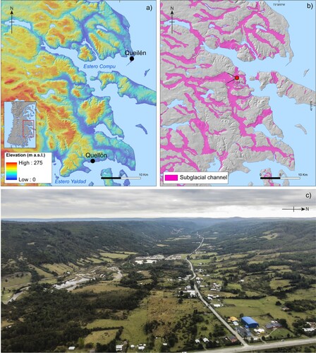
Eastwards, the area between L. Huillinco and the eastern coast of IGC features an irregular morainal topography with discontinuous moraine belts. The most distinctive moraine ridges occur on the eastern shore of L. Huillinco. These ice-marginal features appear to correlate with some isolated moraine fragments located north of the meltwater channels that originate from the Quinched area (Main map). Inboard from these moraines, we recognize numerous parabolic-shaped valleys reaching ∼10 km in length and ∼120 m in depth, occasionally occupied by lakes, and abruptly ending when changes in bedrock lithology occur, we interpret as subglacial channels (; ). These landforms were previously identified by CitationGarcía (Citation2012), who interpreted as glacial troughs formed in a subglacial environment and reworked during subsequent glacial incursions.
Figure 6. (a) ALOS PALSAR digital elevation model of the subglacial channels located in the eastern shore of Isla Grande de Chiloé between Queilen and Quellón ((c)). (b) Geomorphic map of the area illustrating the extent of major subglacial channels. (c) Oblique aerial overview of a subglacial channel. The location and direction are indicated by a red circle with lines in 6b.
To the east of IGC, we identify an ice-contact slope and moraine ridges running N-S along the eastern coast of Isla Lemuy. To the north, this ice-contact slope can be correlated with the moraine ridges and ice-contact slopes of Península Rilán and Isla Quinchao; to the south, this landform is aligned with submerged geomorphic ridges that cross Bahía Yal toward IGC, landforms we interpret as subaqueous moraines (; CitationBatchelor & Dowdeswell, Citation2015). The continuity of this feature matches the ice-contact slope that establishes the eastern coast of IGC between L. Tarahuín and Queilen (Main map).
The rest of the Chilotan islands to the east of Isla Lemuy consist of irregular morainal topography and outwash deposits lacking clear ice-marginal features, suggesting that the Golfo Corcovado ice lobe did not stabilize during deglacial retreat in the interior archipelago.
5.3. Lago Tepuhueico – Estero Compu sector
This sector extents from L. Tepuhueico in the north to L. Yaldad in the south ((c)). From west to east, the first distinctive glacial landforms correspond to a group of outwash plains occupying east-to-west trending valleys that dissect the core of CC and descend toward the western coast of IGC. The most extensive of these originates west of L. Tepuhueico and ranges in elevation from 150 to 50 m a.s.l. We also detect multiple subtle ice-contact slopes between ∼350 and ∼250 m a.s.l. on the eastern flank of CC, adjacent to L. Tepuhueico. Immediately east of that lake, we recognize a group of small outwash plains that descend to the west and follow a N-S direction (Main map).
The interior of IGC is dominated by several subglacial channels imprinted over irregular morainal topography with occasional moraine ridges (). These channels flow westwards reaching ∼50 km in length, and originate from ice-contact slopes or former U-shaped valleys currently flooded by the sea, such as Estero Compu, along the eastern coast of IGC.
A prominent ice-contact slope culminating ∼120 m a.s.l. rims the east coast of IGC between Bahía Yal and Queilen, where it curves westward forming the slopes of Estero Compu. Closely inboard, intermittent moraine ridges occur near Queilen following a N-S direction. These moraines can be traced to submarine ridges, we interpret as subaqueous moraines, towards Isla Tranqui. South of Isla Tranqui, we find NW-SE trending ice-contact slopes running along the east coast of IGC that match the direction of subaqueous moraines (Main map).
5.4. Tantauco sector
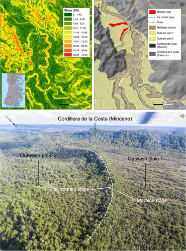
This sector corresponds to the southern tip of IGC ((c)) and has a landscape dominated by the CC, which, at this latitude, curves towards the east occupying most of the island. To the west, close to the Pacific shore, we observe extensive and westward-dipping outwash plains ((a)) enclosed in the valleys excavated on the Miocene sedimentary rocks of CC (CitationSERNAGEOMIN, Citation2003). Northwest of L. Chaiguaco, imprinted over the outwash plains, we detect a well-preserved ice-contact slope topped by sharp moraine ridges in the Río Medina valley ((c) and ). The next valley to the south exhibits remnants of moraine ridges located at similar morphostratigraphic positions.
Figure 7. (a) Oblique aerial overview of the outwash constrained by the Cordillera de la Costa topography in the Tantauco area ((c)). (b) Oblique aerial overview of the southern coastline of Tantauco ((c)).
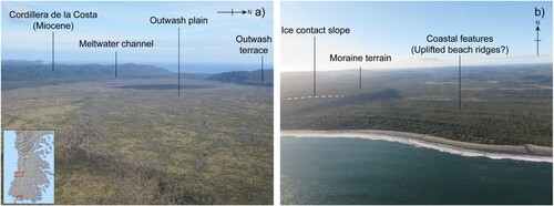
Figure 8. (a) Slope map derived from the ALOS PALSAR digital elevation model of the ice-contact slope located in the Río Medina valley of the Tantauco sector ((c)). (b) Geomorphic map illustrating the distribution of main ice marginal features of a portion of the Río Medina valley and considered as the outermost position of the Golfo Corcovado ice lobe in the Tantauco sector. (c) Oblique aerial overview of the ice-contact slope located in the Río Media basin in the Tantauco sector.
East of L. Chaiguaco, the landscape exhibits a smooth topography mainly composed by ice-moulded knobs of the Paleozoic metamorphic rocks from CC. We identify a subtle ice-contact slope running N-S at an elevation of ∼300 m a.s.l. south of L. Chaiguaco and west of L. Chaiguata (Main map).
The east coast of IGC exhibits a well-defined ice-contact slope culminating at ∼130 m a.s.l. from Estero Yaldad, near Quellón, to the north of Isla San Pedro ((c)). In the latter, massive bedrock outcrops present a rounded ice-sculped plan form, occasionally resulting in parallel rocky lineations of hundreds to thousands of meters in length following a SE-NW direction (Main map), indicative of former ice flow.
The south coast of IGC is characterized by a well-preserved ice-contact slope running E-W at ∼150 m a.s.l. (Main map). Its culmination is associated to moraine terrain accompanied by scattered moraine ridges, which turn towards the Pacific Ocean south of L. Huillín.
In general, the distribution of ice-marginal landforms in the Tantauco sector suggests that glacier flow occurred along a SE to NW axis along Canal Moraleda ((c)), where CitationRodrigo (Citation2006) mapped large-scale subaqueous mega-lineations reaching ∼15 km in length.
6. Discussion
6.1. Glacial limits of the Golfo Corcovado ice lobe
The predominantly discontinuous and poorly preserved nature of ice-marginal landforms in central and southern IGC allow us to address a first-order interpretation of the behavior of the Golfo Corcovado ice lobe. The distribution and morphostratigraphic relations of the most distinctive moraine ridges, ice-contact slopes, and outwash plains, suggest at least four potential glacial limits associated to the Llanquihue glaciation. We named these positions as Corcovado (COR) 1–4, from outermost to innermost ().
Figure 9. Extent of the Golfo Corcovado ice lobe inferred from our geomorphic map. Solid lines represent ice-front position reflected by the geomorphic record. Dashed lines represent inferred ice-front positions due to the fragmentary nature of the geomorphic record. Semitransparent dark blue polygon indicates the inferred extent of the proglacial Lake Castro and black dashed arrow the potential drainage path during its early stages.
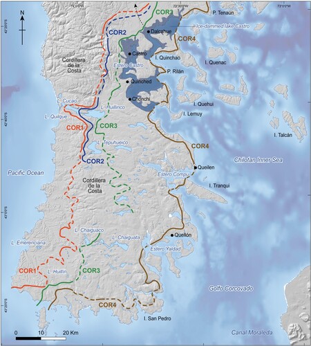
The outermost glacial limit, COR 1 (), is defined by the Butalcura moraines which were first mapped by CitationAndersen et al. (Citation1999), and subsequently recognized by CitationGarcía (Citation2012). These ice-marginal features are morphostratigraphically associated with the sequence of diffuse ice-contact slopes running at the eastern flank of CC distal to L. Pastahué. To the south, in the L. Cucao area, COR 1 appears as the ice-contact slope of L. Quilque, which continues southward along the eastern slope of CC in the L. Tepuhueico sector. In the Tantauco sector, we correlate this ice margin with a series of ice-contact slopes and moraine ridges associated to the outwash plains hosted in valleys that dissect CC. Except for the L. Cucao area, the distribution of deposits and landforms suggests that the Golfo Corcovado ice lobe remained buttressed against CC without reaching the west coast of IGC, at least, during the Llanquihue glaciation. This conclusion validates previous hypotheses based on the southward extrapolation of ice marginal features from the CLD and central IGC (CitationGarcía, Citation2012).
COR 2 () is represented by a diffuse ice-contact slope along the eastern flank of CC distal to Laguna Pastahué, closely inboard of COR 1. To the south, this ice marginal feature can be tentatively traced to the narrowing connecting L. Cucao and L. Huillinco, further south these landforms can be associated with an ice-contact slope plastered along the eastern slope of CC in the L. Tepuhueico sector, at broadly the same elevation. We could not identify ice marginal features attributable to COR 2 in the Tantauco sector of IGC, possibly due to fluvioglacial erosion on the narrow sectors of the valleys traversing the CC, outwash burial, or, alternatively, to the deposition of moraines on the western slope of CC. Hence, the extent of this glacial limit remains elusive in the Tantauco sector of IGC.
The next glacial limit is COR 3 (), which is represented by a group of subtle moraine ridges inboard the Butalcura moraines recognized by CitationAndersen et al. (Citation1999) and CitationGarcía (Citation2012). To the south, near Quinched, COR 3 follows a group of moraine ridge remnants heading west toward the eastern shore of L. Huillinco. Further south, in the L. Tepuhueico area, we did not recognize any distinctive ice-marginal features. We hypothesize that the Golfo Corcovado ice lobe could have reached the headwaters of the outwash plains located east of CC between L. Tepuhueico and L. Yaldad. In the Tantauco sector, COR 3 is represented by an ice-contact slope and minor moraine ridges running N-S between the west shore of L. Chaiguata and south of L. Huillín, where they originate outwash plains that drain toward the Pacific Ocean.
The innermost glacial limit, COR 4 (), comprises prominent ice-contact slope and moraine ridges extending along the eastern and southern coast of IGC, from Punta Tenaún in the north to the Tantauco shore in the south. This ice marginal feature appears to be associated through subaqueous moraine ridges with ice-contact slopes and moraine ridges hosted in Isla Quinchao, I. Lemuy and I. Tranqui. This ice-front position could account for the formation of ice-dammed lake Castro in the Castro-Dalcahue area (CitationGarcía, Citation2012; CitationHeusser et al., Citation1995; CitationHeusser & Flint, Citation1977) and suggests that the Golfo Corcovado ice lobe experienced a stepwise retreat from the east coast of IGC following withdrawal from COR 3, as opposed to a single irreversible pulse.
Overall, the northern and central-southern sectors of IGC present different glacial landform types. To the north of the Castro-Dalcahue area, distinctive moraine ridges associated to extensive outwash plains clearly delineate former ice lobe boundaries (CitationAndersen et al., Citation1999), whereas to the south of Lago Cucao-Huillinco, ice-marginal and glaciofluvial features are diffuse and the landscape is mostly dominated by ice-moulded CC hills furrowed by subglacial channels (Main map). This finding suggests that (i) glaciers in northern IGC advanced over a soft sedimentary bed, whereas, in southern IGC the Golfo Corcovado ice lobe mostly advanced over bedrock outcrops; and (ii) the differences in CC topography between the northern (absence of CC) and central-southern (high and low relief, respectively) sectors of IGC established topographic barriers that affected local glacial dynamics and hydrology. Based on our mapping, which covers for the first time the southern half of IGC, we infer that the Golfo Corcovado ice lobe did not surpass the CC toward the west coast in central and southern IGC, at least, during the last glaciation.
7. Concluding remarks
We present a new map of the landform-sediment associations sculpted and deposited by the Golfo Corcovado ice lobe in the central and southern thirds of IGC and the adjoining archipelago, including the seafloor of the Chilotan Inner Sea.
We distinguish four marginal positions of the Golfo Corcovado ice lobe in IGC (), defined by successive glacial and glaciofluvial landforms along a west-to-east axis. Our results suggest that (i) the Golfo Corcovado ice lobe was mostly butted against the CC during the last glaciation without reaching the Pacific coast of IGC, and (ii) that disappearance of the Golfo Corcovado ice lobe proceeded in a stepwise manner during the initial portion of the Last Glacial Termination (∼17.8–16.8 ka) forming the ice-dammed lake Castro. Our map, thus, provides constraints for further empirical and modeling developments in a key area of the middle latitudes of the Southern Hemisphere.
Software
Spatial information analysis was carried out using ArcGIS 10.4 software. World image in the inset map was composed in MATLAB 2017. Final map production was completed with Adobe Illustrator CC 2020.
Open Scholarship

This article has earned the Center for Open Science badge for Open Data. The data are openly accessible at 10.17632/hzg2tvvxk8.1
TJOM_2008538_Supplementary Material
Download PDF (35.4 MB)Acknowledgements
The authors are grateful to Gaspar González, Pablo Ugalde, Joaquín Rivera and Ignacio Aguirre for field assistance. The authors also thank to Dr. Bethan Davies, Dr. Jorge Rabassa and Mr. Chris Orton for contributing to improve the original manuscript and map with their reviews.
Disclosure statement
No potential conflict of interest was reported by the author(s).
Data availability statement
ESRI shapefiles (*.shp) for visualizing the map produced in this study are freely available, as long as original publication is properly cited. A folder with twenty-four shapefiles can be downloaded from a Mendeley Data online repository using the following doi:10.17632/hzg2tvvxk8.1.
Additional information
Funding
References
- Alloway, B. V., Almond, P. C., Moreno, P. I., Sagredo, E., Kaplan, M. R., Kubik, P. W., & Tonkin, P. J. (2018). Mid-latitude trans-Pacific reconstructions and comparisons of coupled glacial/interglacial climate cycles based on soil stratigraphy of cover-beds. Quaternary Science Reviews, 189, 57–75. https://doi.org/10.1016/j.quascirev.2018.04.005
- Alloway, B. V., Moreno, P. I., Pearce, N., De Pol-Holz, R., Henríquez, W., Pesce, O., Sagredo, E., Villarosa, G., & Outes, V. (2017a). Stratigraphy, age and correlation of Lepué tephra: A widespread c. 11,000 cal. A BP marker horizon sourced from the Chaitén sector of southern Chile. Journal of Quaternary Science, 32(6), 795–829. https://doi.org/10.1002/jqs.2976
- Alloway, B. V., Pearce, N. J. G., Moreno, P. I., Villarosa, G., Jara, I., Ricardo De Pol-Holz, R., & Outes, V. (2017b). An 18,000 year-long eruptive record from Volcán Chaitén, northwestern Patagonia: Paleoenvironmental and hazard-assessment implications. Quaternary Science Reviews, 168, 151–181. https://doi.org/10.1016/j.quascirev.2017.05.011
- Andersen, B. G., Denton, G. H., & Lowell, T. V. (1999). Glacial geomorphologic maps of Llanquihue drift in the area of the southern Lake District, Chile. Geografiska Annaler, Series A: Physical Geography, 81(2), 155–166. https://doi.org/10.1111/1468-0459.00056
- Andersen, G. G., Denton, G. H., Heusser, C. J., Lowell, T. V., Moreno, P. I., Hauser, A., Heusser, L. E., Schlüchter, C., & Marchants, D. R. (1995). Climate, vegetation and glacier fluctuations in Chile, between 40o30’ and 42o30’ S latitude. A short review of preliminary results. Quaternary International, 28, 199–201. https://doi.org/10.1016/1040-6182(95)00038-K
- Batchelor, C. L., & Dowdeswell, J. A. (2015). Ice-sheet grounding-zone wedges (GZWs) on hih-latitude continental margins. Marine Geology, 363, 65–92. https://doi.org/10.1016/j.margeo.2015.02.001
- Bendle, J. M., Thorndycraft, V. R., & Palmer, A. P. (2017). The glacial geomorphology of the lago Buenos Aires and lago pueyrredón ice lobes of central patagonia. Journal of Maps, 13(2), 654–673. https://doi.org/10.1080/17445647.2017.1351908
- Caldenius, C. C. (1932). Las glaciaciones cuaternarias en la Patagonia y Tierra del Fuego. Geografiska Annaler Series A: Physical Geography, 14(1-2), 1–164. https://doi.org/10.1080/20014422.1932.11880545
- Cembrano, J., Hervé, F., & Lavenu, A. (1996). The Liquiñe-Ofqui fault zone: A long-lived intra-arc fault system in southern Chile. Tectonophysics, 259(1-3), 55–66. https://doi.org/10.1016/0040-1951(95)00066-6
- Cembrano, J., Schermer, E., Lavenu, A., & Sanhueza, A. (2000). Contrasting nature of deformation along an intra-arc shear zone, the Liquiñe-Ofqui fault zone, southern Chilean Andes. Tectonophysics, 319(2), 129–149. https://doi.org/10.1016/S0040-1951(99)00321-2
- Darvill, C. M., Stokes, C. R., Bentley, M. J., & Lovell, H. (2014). A glacial geomorphological map of the southernmost ice lobes of Patagonia: The Bahía Inútil-San Sebastián, Magellan, Otway, Skyring and Río Gallegos lobes. Journal of Maps, 10(3), 500–520. https://doi.org/10.1080/17445647.2014.890134
- Davies, B. J., Darvill, C. M., Lovell, H., Bendle, J. M., Dowdeswell, J. A., Fabel, D., García, J. L., Geiger, A., Glasser, N. F., Gheorghiu, D. M., Harrison, S., Hein, A. S., Kaplan, M. R., Martin, J. R. V., Mendelová, M., Palmer, A., Pelto, M., Rodés, A., Sagredo, E. A., … Thorndycraft, V. R. (2020). The evolution of the Patagonian Ice Sheet from 35 ka to the present day (PATICE). Earth-Science Reviews, (204), 103152. https://doi.org/10.1016/j.meegid.2020.104171
- Denton, G. H., Lowell, T. V., Heusser, C. J., Schlüchter, C., Andersen, B. G., Heusser, L. E., Moreno, P. I., & Marchant, D. R. (1999). Geomorphology, stratigraphy, and radiocarbon chronology of Llanquihue drift in the area of the southern Lake District, Sena Reloncaví, and Isla Grande de Chiloé, Chile. Geografiska Annaler, Series A: Physical Geography, 81(2), 167–229. https://doi.org/10.1111/j.0435-3676.1999.00057.x
- García, J. L. (2012). Late pleistocene ice fluctuations and glacial geomorphology of the Archipiélago de Chiloé, southern Chile. Geografiska Annaler, Series A: Physical Geography, 94(4), 459–479. https://doi.org/10.1111/j.1468-0459.2012.00471.x
- García, J. L., Lüthgens, C., Vega, R. M., Rodés, A., Hein, A. S., & Binnie, S. A. (2021). A composite 10Be, IR-50 and 14C chronology of the pre-Last Glacial Maximum (LGM) full ice extent of the western Patagonian Ice Sheet on the Isla de Chiloé, south Chile (42oS). Quaternary Science Journal, 70(1), 105–128. https://doi.org/10.5194/egqsj-70-105-2021
- Garreaud, R., Lopez, P., Minvielle, M., & Rojas, M. (2013). Large-scale control on the Patagonian climate. Journal of Climate, 26(1), 215–230. https://doi.org/10.1175/JCLI-D-12-00001.1
- Heusser, C. J. (1974). Vegetation and climate of the southern Chilean Lake District during and since the last interglaciation. Quaternary Research, 4(3), 290–315. https://doi.org/10.1016/0033-5894(74)90018-0
- Heusser, C. J. (1990). Chilotan piedmont glacier in the Southern Andes during the last glacial maximum. Andean Geology, 17(1), 3–18. https://doi.org/10.5027/andgeoV17n1-a01
- Heusser, C. J., Denton, G. H., Hauser, A., Andersen, B. G., & Lowell, T. V. (1995). Quaternary pollen records from the Archipielago de Chiloe in the context of glaciation and climate. Andean Geology, 22(1), 25–46. https://doi.org/10.5027/andgeoV22n1-a02
- Heusser, C. J., & Flint, R. F. (1977). Quaternary glaciations and environments of northern isla chiloé, Chile. Geology, 5(5), 305–308. https://doi.org/10.1130/0091-7613(1977)5<305:QGAEON>2.0.CO;2
- Heusser, C. J., Heusser, L. E., & Lowell, T. V. (1999). Paleoecology of the southern Chilean lake district-Isla Grande de Chiloé during middle-late Llanquihue glaciation and deglaciation. Geografiska Annaler, Series A: Physical Geography, 81(2), 231–284. https://doi.org/10.1111/1468-0459.00058
- Hogg, A. G., Heaton, T. J., Hua, Q., Palmer, J. G., Turney, C. S. M., Southon, J., Bayliss, A., Blackwell, P. G., Boswijk, G., Bronk Ramsey, C., Pearson, C., Petchey, F., Reimer, P., Reimer, R., & Wacker, L. (2020). SHCal20 southern hemisphere calibration, 0–55,000 years cal BP. Radiocarbon, 62(4), 759–778. https://doi.org/10.1017/RDC.2020.59
- Laugénie, C. (1982). La Région des Lacs, Chili meridional [Ph.D. Diss., Universit de Bordeaux].
- Leger, T. P. M., Hein, A. S., Bingham, R. G., Martini, M. A., Soteres, R. L., Sagredo, E. A., & Martínez, O. A. (2020). The glacial geomorphology of the Río Corcovado, Río Huemul and Lago Palena/General Vintter valleys, northeastern Patagonia (43°S, 71°W). Journal of Maps, 16(2), 651–668. https://doi.org/10.1080/17445647.2020.1794990
- Lovell, H., Stokes, C. R., Bentley, M. J., & Benn, D. I. (2012). A glacial geomorphological map of the Seno Skyring-Seno Otway-Strait of Magellan region, southernmost Patagonia. Journal of Maps, 7(1), 318–339. https://doi.org/10.4113/jom.2011.1156
- Lowell, T. V., Heusser, C. J., Andersen, B. G., Moreno, P. I., Hauser, A., Heusser, L. E., Schluchter, C., Marchant, D. R., & Denton, G. H. (1995). Interhemispheric correlation of late Pleistocene glacial events. Science, 269(5230), 1541–1549. https://doi.org/10.1126/science.269.5230.1541
- Mercer, J. (1972). Chilean glacial chronology 20,000 to 11,000 carbon-14 years ago: Some global comparisons. Science, 176(4039), 1118–1120. https://doi.org/10.1126/science.176.4039.1118
- Mercer, J. H. (1976). Glacial history of southernmost South America. Quaternary Research, 6(2), 125–166. https://doi.org/10.1016/0033-5894(76)90047-8
- Moreno, P. I., Denton, G. H., Moreno, H., Lowell, T. V., Putnam, A. E., & Kaplan, M. R. (2015). Radiocarbon chronology of the last glacial maximum and its termination in northwestern Patagonia. Quaternary Science Reviews, 122, 233–249. https://doi.org/10.1016/j.quascirev.2015.05.027
- Porter, S. C. (1981). Pleistocene glaciation in the southern Lake District of Chile. Quaternary Research, 16(3), 263–292. https://doi.org/10.1016/0033-5894(81)90013-2
- Rodrigo, C. (2006). Topografía submarina en canales de la Patagonia Norte. In N. Silva, & S. Palma (Eds.), Avances en el conocimiento oceanográfico de las aguas interiores chilenas, Puerto Montt a cabo de Hornos (pp. 19–23). Comité Oceanográfico Nacional.
- Ruiz, S., & Madariaga, R. (2018). Historical and recent large megathrust earthquakes in Chile. Tectonophysics, 733, 37–56. https://doi.org/10.1016/j.tecto.2018.01.015
- Saldías, G. S., Hernandez, W., Lara, C., Muñoz, R., Rojas, C., Vásquez, S., Pérez-Santos, I., & Soto-Mardones, L. (2021). Seasonal variability of SST fronts in the Inner Sea of Chiloé and its adjacent coastal ocean, northern Patagonia. Remote Sensing, 13(2), 181. https://doi.org/10.3390/rs13020181
- SERNAGEOMIN. (2003). Mapa Geológico de Chile: versión digital. Servicio Nacional de Geología y Minería, Publicación Digital, 4.
- Soteres, R. L., Peltier, C., Kaplan, M. R., & Sagredo, E. A. (2020). Glacial geomorphology of the Strait of Magellan ice lobe, southernmost Patagonia, South America. Journal of Maps, 16(2), 299–312. https://doi.org/10.1080/17445647.2020.1736197
- Stern, C. R., Moreno, H., López-Escobar, L., Clavero, J. E., Lara, L. E., Naranjo, J. A., Parada, M. A., & Skewes, A. M. (2007). Chilean volcanoes. In T. Moreno, & W. Gibbons (Eds.), The Geology of Chile (pp. 147–178). The Geological Society. https://doi.org/10.1144/GOCH
- Strub, P. T., James, C., Montecino, V., Rutllant, J. A., & Blanco, J. L. (2019). Ocean circulation along the southern Chile transition region (38o–46oS): Mean, seasonal and interannual variability, with focus on 2014–2016. Progress in Oceanography, 172, 159–198. https://doi.org/10.1016/j.pocean.2019.01.004
- Turbek, S. E., & Lowell, T. V. (1999). Glacial deposition along an ice-contact slope: An example from the southern Lake District, Chile. Geografiska Annaler, Series A: Physical Geography, 81(2), 325–346. https://doi.org/10.1111/1468-0459.00061
- Villagrán, C. (1985). Análisis palinológico de los cambios vegetacionales durante el tardiglacial y postglacial en Chiloé, Chile. Revista Chilena de Historia Natural, 58(1), 57–69.
- Villagrán, C. (1988). Late Quaternary vegetation of southern Isla Grande de Chiloé, Chile. Quaternary Research, 29(3), 294–306. doi:10.1016/0033-5894(88)90037-3