
ABSTRACT
Detailed sedimentological studies of the university main campus of São Paulo city, Brazil, revealed a significant unconformity at the top of the Cenozoic sedimentary deposits of the São Paulo Formation. This unconformity is overlapped by Quaternary sediments which can be traced in 1:20,000 scale and are here named as the Bosque Formation. This unit is characterized by poorly sorted mud deposits and very fine-grained red sand with granule- and pebble-sized clasts of the underlying São Paulo Formation. Furthermore, it overlies topographic highs of the Precambrian basement, and is laterally interfingered with fluvial terraces; it is eroded by the modern river at the lower reaches of the outcrops. The Bosque Formation records sedimentation characterized by a widespread mudflow that overlays old alluviums sediments, and was likely deposited during the beginning of the Holocene.
1. Introduction
The Cenozoic São Paulo Basin has been studied by naturalists and historical geological surveys since the nineteenth century (e.g. CitationMawe, 1812; CitationPissis, 1842; CitationVarnhagen, 1818), and the knowledge of the nature and distribution of its deposits was crucial to the urban growth of São Paulo, southeastern Brazil (CitationAb’Sáber, 1969; CitationAlmeida, 1958). The uppermost layers of the up to 300 m-thick Paleogene continental deposits within the São Paulo Basin are grouped as the São Paulo Formation, which is characterized in its type section by well sorted yellow sandstones with associated granule-conglomerates and mudstones. The São Paulo Formation sandstones typically present intense limonitic cement distributed in multiple horizons (CitationSuguio & Barbour, 1969). An up to 20 m-thick uppermost ‘red stratum’ unconformably overlies the São Paulo Formation and is characterized mainly by red, fine-grained sediments (e.g. CitationMoraes-Rego & Santos, 1938; CitationPissis, 1842) which are preserved in a large area within the basin. Other authors have described this uppermost stratum as a weathered horizon of the Cenozoic São Paulo Formation (e.g. CitationAlmeida, 1955; CitationSuguio & Barbour, 1969).
The São Paulo Basin deposits are scarcely exposed, as their area of occurrence comprises one of the largest metropolises in the world; an exception to that is the 10 km2 urban window in the area of one of the local universities, which offers an opportunity to investigate the evolution and stratigraphy of the Cenozoic São Paulo Basin. The data presented in this study consist of mapping, and stratigraphy and sedimentary facies analyses to characterize the abovementioned ‘red stratum’ (Main Map). We present a new geological map that displays a new stratigraphic unit, correlating the area with the stratigraphy of the basin in the city.
2. Geographical and geological setting
2.1. Pioneer geographical and geological studies in the region
The city of São Paulo and its surroundings were object of one of the first geological studies in Brazil (e.g. CitationBranner, 1903; CitationHenrique-Pinto & Janasi, 2014; CitationIglesias, 1943). The first iron mill of the Americas was developed in the region during the 1600s to explore the ‘argillaceous iron ore’ around of the Jeribatiba River (now Pinheiros River) (CitationAndrada e Silva & Andrada, 1820; CitationMartins, 1943; CitationVarnhagen, 1818). The geological stratum explored by those iron mines were firstly described as alluvium deposits composed of grit-stone cemented by iron oxide; small amounts of gold commonly concentrated directly on the pavestone of the São Paulo village during heavy rain events (CitationMawe, 1812; CitationOliveira, 1892).
One of the first physiographic elements ever reported for the geomorphology of the São Paulo city includes the presence of a 40 km-long plateau that separates the Coastal Range from the Mantiqueira Range (CitationVarnhagen, 1818). The historic geological section of the point that marks the foundation of São Paulo city (Pátio do Colégio) records a basal succession unconformably deposited above the so-called ‘limonite geodes’ by red, rusty sediments (CitationPissis, 1842). This erosive unconformity was originally named ‘the diluvium layer’, and has historically been used as a chronostratigraphy marker within the São Paulo Basin, separating the Quaternary from older Cenozoic successions (CitationPissis, 1842). Such ‘red stratum’ has been later considered as a weathered horizon developed above the groundwater level (CitationAlmeida, 1952, Citation1955; CitationSuguio & Barbour, 1969). Importantly, this red layer (informally named as ‘porous red clay’) is distinguishable from lower units regarding their respective geomechanical behaviour (CitationPichler, 1950).
CitationMoraes-Rego (1933) introduced the first stratigraphic designation to these successions which he grouped in the São Paulo Layers, and which was latter elevated to the status of a formation by CitationMezzalira (1966). The São Paulo Formation had its minimum age only inferred, due to the remarkable sparseness of preserved fossiliferous content, to be younger than an early Cenozoic peniplain named the Japi Peniplain (CitationAlmeida, 1952; CitationMoraes-Rego, 1932) and than the erosion of the upper Tietê surface, which is located around 830 m asl; thus, its sedimentation is interpreted to have occurred between the Eocene and Pleistocene (CitationAb’Sáber, 1947; CitationAlmeida, 1955).
Hydrogeological studies provided for the first time a subsurface topography map of the basement, revealing that the basin fill is characterized by sandy channel deposits isolated in muddy floodplain deposits, which rarely exceed 300 m in thickness (CitationLeinz & Carvalho, 1957). These deposits are described to have been reworked in the modern river floodplain (CitationAb’Sáber, 1957), which can fluctuate between 720 and 725 m asl.
2.2. Chronostratigraphic relations
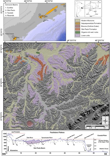
The Paulistano Plateau (CitationAlmeida, 1952) is a geomorphological feature originated from the Pliocene peniplain (CitationMoraes-Rego, 1932) over a Precambrian basement. Multiple grabens developed on this plateau during the Cenozoic (e.g. CitationJames, 1933), and some preserve >300 m of continental deposits which accumulated in lacustrine and fluvial environments (e.g. CitationFreitas, 1951; CitationMoraes-Rego, 1933; CitationRiccomini et al., 2004); these grabens were collectively grouped as the Serra do Mar Rift System (CitationAlmeida, 1976). The São Paulo Basin preserves the second thickest sedimentary succession of those grabens, and comprises mainly river-channel and floodplain deposits, with minor associated lacustrine deposits. These deposits were grouped in the São Paulo Formation (CitationMezzalira, 1966) within the ‘Continental Tafrogenic Basin System of Southeast Brazil’ (CitationMelo et al., 1985) ().
Figure 1. Geological map of the São Paulo Basin (original shapes compiled from http://geosampa.prefeitura.sp.gov.br/PaginasPublicas/_SBC.aspx) including NW-SE section modified from CitationAlmeida (1958).
The thicknesses, and the low degree of diagenesis, of most of the São Paulo Basin sediments led some authors to position the entire sequence within the Quaternary (e.g. CitationFreitas, 1951; CitationMendes, 1950). On the other hand, stratigraphic analyses suggest contrasting differences between the São Paulo Formation and old alluviums of the Tietê and Pinheiros rivers (CitationSuguio & Takahashi, 1970), and this includes the absence of limonitic cement, always singularly associated with the upper strata of the São Paulo Formation (e.g. CitationMendes, 1943; CitationSuguio & Barbour, 1969).
The basal succession of the modern Pinheiros River floodplain deposits can be identified below 725 m asl, where it was mapped as the main occurrences of the modern and old alluvium, contrasting with older Cenozoic successions. CitationAb’Sáber (1957) and CitationLuz and Rodrigues (2013) described the architecture of the fluvial tributary system in the area and classified it into three main components: (i) bottom floodplain; (ii) intermediate terraces; and (iii) high terraces. This succession is characterized by the predominance of organic-rich clay and silt with subordinate poorly sorted sand preserved within abandoned meanders and scrolls related to the currently active Pinheiros River channel (CitationLuz & Rodrigues, 2013). Lower floodplain deposits are commonly covered by peat deposits, typically on the top of abandoned meanders, as documented in hydrogeological monitoring wells within the São Paulo University (USP) main campus (CitationIritani, 1993).
Radiocarbon dating of some old colluvium successions elsewhere within the São Paulo Basin yielded ages ranging between 12,890 ± 70 and 10,220 ± 80 years BP (CitationTakiya, 1997). This period coincides with the end of the Late Glacial Interstadial passing through the Younger Dryas climatic period, as is well recorded in the northern hemisphere (e.g. CitationCarlson, 2013; CitationMeissner, 2007). In contrast, modern colluvium and alluvium sedimentation occurred in the São Paulo Basin during the late Holocene, as supported by radiocarbon analysis which yielded ages ranging between 3,000 ± 140 and 610 ± 80 years BP (CitationTakiya, 1997). The region of the University of São Paulo main campus harboured an important sand pit that mined the alluvial sediments for urban construction (CitationAb’Sáber, 1986); these sedimentary deposits preserve an expressive number of carbonized fossil trunks with 14C ages reported as ∼40,000 years BP (CitationSuguio & Takahashi, 1970).
3. Methods
A map was produced at the scale of 1:20,000, integrating historical geological evolution with previous descriptions of hydrogeological monitoring wells (CitationIritani, 1993), and detailed geophysical maps (CitationMarangoni et al., 2017; CitationPorsani et al., 2004, Citation2012). Field work has covered more than one outcrop every 200 m. The sparseness, and very limited lateral and vertical extent, of the study area natural outcrops (i.e. typical of urban areas) determined a mapping approach which consisted of the detailed scrutiny of every accessible hillside; infra structure works in the university allowed for the study of distinct trenches. Shape-files of the drainage and civil construction are available on http://dados.prefeitura.sp.gov.br/ as well as a georeferenced São Paulo urban map made before the river canalization in the 1930s, from which the original drainage and abandoned meanders shapes were compiled (http://geosampa.prefeitura.sp.gov.br/PaginasPublicas/_SBC.aspx).
4. Geology of the university main campus and surroundings
Geological mapping of the USP main campus and surrounding areas reveals a wide range of geological features. The isopach of the sedimentary successions reveals that the greatest depths can be as thick as 70 m in the northwest and northeast sectors of the area, under the Jaguaré River and Pinheiros River (old sand-port), respectively. Sudden disturbances in the geometry of the isopach lines (field points IAG – 1 and IAG – 3), may indicate the presence of syn-contemporaneous fault activity or, alternatively, fluvial lateral erosion.
Previous large-scale geological maps (1:100,000) which include the area of the university campus and surroundings suggested the presence of the São Paulo Formation within the study area (e.g. CitationCoutinho, 1980). Strongly compacted mudrocks that commonly exhibit greyish and greenish colours, and identified as part of the ‘Resende Formation’ in other parts of the basin (e.g. CitationTakiya, 1997), were not identified in this study. Existing outcrops of the São Paulo Formation can be found in some points within the area (field points; FB – 43, 97 and 46), while other outcrops described as part of this formation within the campus (e.g. CitationSuguio & Barbour, 1969) are no longer exposed, as is the outcrop described and photographed by the authors in 2008 (field point FB – 01).
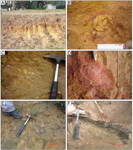
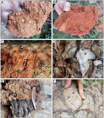
The São Paulo Formation in the area has an intense yellow colour signature and it is composed of well-sorted, fine-grained sand and clay (a) containing sparse clasts of mottled clay (b and c), as exposed in its type section (CitationSuguio & Barbour, 1969). Secondary weathering highlights small-scale cross stratifications (d), many of which are cross-cut by clastic dykes, which are composed of medium-grained sand with limonitic cement (e and f).
Figure 2. The main features of the São Paulo Formation in the area: A – well-sorted, fine-grained sand and clay with intense yellow colour signature; B – clasts of mottled clay; C – pebbly sand with clasts of mottled clay; D – small-scale cross stratifications; E – clastic dykes composed of medium-grained sand; F – limonitic cement within the São Paulo Formation in the area of the geological institute of the university.
Above the secondary drainages of the Pequeno and Pirajussara-Mirim rivers, between 755 and 775 m asl, near the main entrance of IPEN institute (field point FB – 102), layers of purple massive clay interlayered with fine- to medium-grained sand with matrix of a rusty aspect are present; they preserve well-rounded pebbles in the foresets of cross-stratification, typical of fluvial deposition ().
Figure 3. Outcrop near to the main entrance of IPEN institute (field point FB – 102).
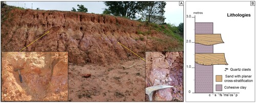
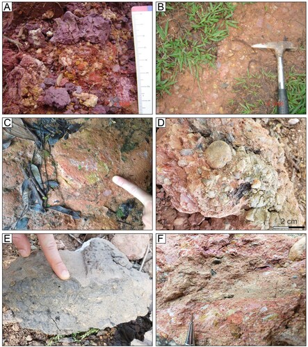
A significant unconformity directly overlies the São Paulo Formation and separates the latter from >7 m of matrix-rich purplish non-consolidated conglomerate (), which grades towards the top to very fine-grained red sand characterized by rusty aspects (a and b) with abundant angular clasts of quartz. Subtle cross-stratifications can also be observed (c).
Figure 4. Sedimentary log of the unconformity between the São Paulo Formation and the Bosque Formation.
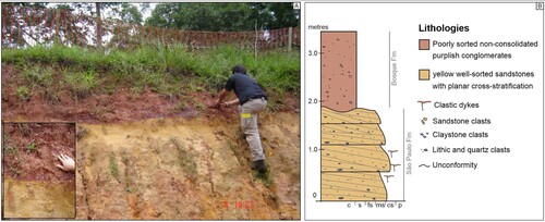
Figure 5. The main features of the Bosque Formation in the area: A, B and C – red-sediments with rusty aspects; D – organic-rich grey clays; E – peats deposits; F – facies exhibit intraformational clasts of red sand.
The intense red colour of the uppermost layer can be identified in many locations of the study area, and it can reach thicknesses of up to 30 m in some places (e.g. field point FB – 61). This unit also occurs as thin layers directly covering elevated topographic positions of the basement, as well as in the intermediate terraces, where it is interfingered with organic-rich grey clays (d) and peats (e). Some conglomerate facies exhibit intraformational clasts of red sand (f), indicating syn-sedimentary reworking of this unit and that the red colour is a primary feature.
The matrix-supported, poorly sorted non-consolidated purplish conglomerates (a, b, c and f) record mudflow deposition with sources mainly from the São Paulo Formation (i.e. yellow well-sorted fine-grained sandstones with diagenetic iron-rich cement, purple massive claystone and conglomerate). The conglomerates are characterized by pebble to cobble clasts supported by poorly sorted mud with little to no stratification. Locally, this unit occurs interlayered with intermediate terraces containing unconsolidated gravel preserving carbonized wood (d) and organic-rich grey-mud (e); clay clasts are commonly compacted (f). In contrast, the intermediate terraces are cross-cut by the modern river floodplain.
Figure 6. The main features of the Bosque Formation in the area: A, B and C – matrix-rich purplish non-consolidated conglomerates; D – matrix-rich purplish non-consolidated conglomerates containing carbonized wood interlayered with intermediate terraces; E – organic-rich grey-mud; F – structures recording commonly compacted clay clasts.
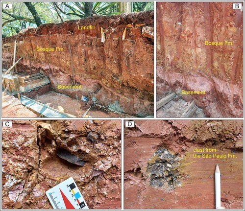
Evidence of debris flow deposits directly overlying the crystalline basement can be found in some places (e.g. field point FB – 128). Right below the unconformity, the basement exhibits an up to 5 cm weathering profile of whitish colour, suggesting a period of exposure of basement rocks prior to deposition of the Bosque Formation (A). Fragments of the São Paulo Formation are abundant; some are characterized by fine-grained, well-sorted sandstones with limonitic cement (B), while others are characterized by polymictic breccias, also with matrix replaced by limonitic cement (C).
Figure 7. A and B – Contact between Basement and the Bosque Formation. C – Detail of clast composed of fine grained well sorted arenites with limonitic cement. D – Detail of clast composed of polymyctic breccias with matrix replaced by limonitic cement.
5. Discussion
Our studies reveal a significant regional unconformity within the São Paulo Basin. The uppermost succession, the ‘red stratum’, preserves clasts of arenites and conglomerates with limonitic cement from the São Paulo Formation, implying that the latter was the source for the overlying succession after diagenesis. The here described purplish mud deposits with abundant clasts of the São Paulo Formation and the very fine-grained red sands with rusty aspects are mainly exposed in the woodlands (i.e. Bosque in Portuguese) of the University; therefore, we hereby name this sequence as the Bosque Formation.
The Bosque Formation is more susceptible to erosion and anthropic reworking, and much of its original thickness has probably already been eroded; yet, it is possible to discriminate two members with lateral correlations: (i) very fine-grained red sand characterized by rusty aspects covering the majority of the upper areas, and (ii) matrix-rich purplish non-consolidated conglomerates that occur also interlayered with intermediate terraces.
The regional areal extent of the Bosque Formation can be traced through a >14 km-long NNE-SSW section which the first constructed metro-line in the city of São Paulo cuts through; the unconformity with the top of the section, the ‘red stratum’, is an evident stratigraphic feature resembling that observed by CitationPissis (1842) ().
Figure 8. A – Historic geological section of the point that marks the foundation of the São Paulo city (Pátio do Colégio) coloured from the original picture made by CitationPissis (1842). 1 – yellow clay; 2 – mottled clay; 3 – quartz sandstone; 4 – red sandstones. B – Maps location and regional shape of the São Paulo Basin, points of monitoring wells compiled from http://siagasweb.cprm.gov.br/layout/; C – Isopach lines of the Bosque Formation; D – NNE-SSW geological cross-section and stations of the metro-line 1 within the São Paulo city (1 – Precambrian Basement; 2 – Lower units composed of very compact brownish medium-coarse sandstones with rare lenses of mudrock; 3 – Lower units composed of very compact greyish mudrocks with common lenses of sandstone; 4 – São Paulo Formation represented by yellow and mottled clay and siltstones with abundant lenses of well sorted fine-grained sandstones with framework often replaced by limonitic cement; 5 – Bosque Formation; 6 – Modern alluviums; 7 – Landfill; 8 – Expressive occurrence of limonitic cement; 9 – Debris from the São Paulo Formation highlighted by the accumulation of clasts of sandstones with limonitic cement; 10 – Monitoring-wells performed during the construction of the north-south subway line).
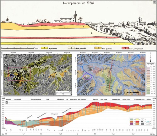
The Bosque Formation can vary from a few metres up to 20 m thick, suggesting an erosional unconformity with sedimentation filling paleo-topographic valleys with the presence of debris from the São Paulo Formation, highlighted by the accumulation of clasts of sandstones and conglomerates with limonitic cement. Disturbances in the geometry of the isopach lines may indicate the presence of syn-contemporaneous fault activity, suggesting early Holocene tectonic disturbance within the region; alternatively, this may result from lateral river erosion (). Just as observed with the university campus, the Bosque Formation has been reworked by the modern river floodplain, between 720 and 725 m asl.
6. Conclusions
Mapping of the USP main campus and surrounding areas, with support of historical descriptions from the literature, reveals a significant unconformity at the top of the São Paulo Formation, which is overlain by up to 30 m thick of deposits, here named the Bosque Formation. It preserves abundant clasts of the São Paulo Formation, many of which present the typically intense limonitic cement of that succession, revealing significant erosion of the São Paulo Formation. The basement was intensely weathered before a widespread event of mudflow deposition which is recorded in the Bosque Formation, likely deposited during the beginning of the Holocene. The Bosque Formation is the geological unit with the largest surface areal extent in the area of the USP main campus, and it covers a large area of the São Paulo basin, as it can be recognized not only from natural outcrops, but also in borehole data elsewhere in the city.
Software
The geological cartography database has been managed in ESRI ArcGIS software and the final layout was made using CorelDRAW software.
TJOM_A_2018367_Supplementarymaterial
Download PDF (6.2 MB)Acknowledgements
We would like to thank the USP, Instituto Butantã, IPEN, IPT, CPA/M-5 and 51° DP Butantã for allowing access to this study, which did not receive any public or private financial support. The authors acknowledge the Metro of São Paulo (Secretaria de Transportes Metropolitanos), in particular Marcelo D. Monteiro to kindly provide the descriptions of monitoring-wells of the constructed lines and the CAP Engenharia e Geotecnia Ltda to provide information about one monitoring well (point CAP-1). We would like to thank Natasha Marteleto for productive discussions on the subject, also, Carlos Tomba and Felipe Ochoa for help in fieldwork. We kindly thank the careful review and comments from Editor Mike Smith, Associate Editor Jasper Knight, and reviewers Fabiano Pupim, Julio Paisani, and Bieke Cattoor.
Data availability statement
Data openly available in a public repository that issues datasets with DOIs.
Disclosure statement
No potential conflict of interest was reported by the author(s).
Related Research Data
References
- Ab’Sáber, A. N. (1947). Geomorfologia da Região do Jaraguá, em São Paulo. Anais da Associação dos Geógrafos Brasileiros, 1, 32–40.
- Ab’Sáber, A. N. (1957). Geomorfologia do sítio urbano de São Paulo. Cotia-SP: Ateliê Editoral, Fac-Similar 50 anos, 2007. 349p.
- Ab’Sáber, A. N. (1969). Uma Revisão do Quaternário Paulista: Do presente para o passado. Revista Brasileira de Geografia, 31(4), 1–51.
- Ab’Sáber, A. N. (1986). O campus e a metrópole. Revista da Universidade de São Paulo, 3(3), 55–90. https://doi.org/10.11606/issn.2595-2501.rusp.1986.132202
- Almeida, F. F. M. (1952). Novas occorências de camadas supostas pliocênicas. Boletim da Sociedade Brasileira de Geologia, 1, 53–58.
- Almeida, F. F. M. (1955). As Camadas de São Paulo e a Tectônica da Serra da Cantareira. Boletim da Sociedade Brasileira de Geologia, 2(4), 23–40.
- Almeida, F. F. M. (1958). O Planalto Paulistano. In: A. de Azevedo: A Cidade de São Paulo - estudo de geografia urbana. Associação dos Geografos Brasileiros. Companhia Editora Nacional, v.1: 113–167.
- Almeida, F. F. M. (1976). The system of continental rifts bordering the Santos Basin, Brazil. Anais da Academia Brasileira de Ciências, 48, 15–26.
- Andrada e Silva, J. B., & Andrada, M. F. R. (1820). Viagem mineralógica na Província de São Paulo (Primeira Parte). (transcrição) Boletim Paulista de Geografia. São Paulo, março de 1954: 66–74.
- Branner, J. C. (1903). A bibliography of the geology, mineralogy and paleontology of Brazil. Archivos do Museu Nacional, Rio de Janeiro, v, XII, 197–309.
- Carlson, A. E. (2013). The younger dryas climate event. In S. A. Elias (Ed.), Encyclopedia of quaternary science (Vol. 3, pp. 126–134). Elsevier. https://doi.org/10.1016/B978-0-444-53643-3.00029-7
- Coutinho, J. M. V. (1980). Mapa geológico da Grande São Paulo, 1: 100.000. EMPLASA, 2 folhas.
- Freitas, R. O. (1951). Sobre a origem da Bacia de São Paulo. Boletim Paulista de Geografia, notas prévias, 9, 60–64.
- Henrique-Pinto, R., & Janasi, V. A. (2014). Histórico do Conhecimento Geológico sobre o Pré-Cambriano Paulista até o ano de 1955. Terrae Didática, 10, 74–81. https://doi.org/10.20396/td.v10i1.8637387
- Iglesias, D. (1943). Bibliografia e Índice da Geologia do Brasil, 1641-1940. Departamento Nacional da Produção Mineral, Divisão de Geologia e Mineralogia, Boletim n° 111. 323p.
- Iritani, M. A. (1993). Potencial Hidrogeológico da Cidade Universitária de São Paulo. São Paulo, SP. Master Thesis, Instituto de Geociências – Universidade de São Paulo. 97 p.
- James, P. E. (1933). The surface configuration of southeastern Brazil. Annals of the Association of American Geographers, 23(3), 165–193. https://doi.org/10.1080/00045603309357119
- Leinz, V., & Carvalho, A. M. V. (1957). Contribuição à geologia da Bacia de São Paulo. Boletim da Universidade de São Paulo, FFCL, Geologia, 205(15), 1–61.
- Luz, R. A., & Rodrigues, C. (2013). Reconstituição geomorfológica de planícies fluviais urbanizadas: o caso do rio Pinheiros, São Paulo-SP. Revista Brasileira de Geomorfologia, 14, 47–57. https://doi.org/10.20502/rbg.v14i1.354
- Marangoni, R. Y., Moura, D. S., & Ferreira, H. (2017). Mapas de anomalias gravimétricas da Cidade Universitária Armando Salles de Oliveira - USP/SP. Revista do Instituto de Geociências - USP, 17(2), 227–268. https://doi.org/10.11606/issn.2316-9095.v17-120698
- Martins, F. P. (1943). A Propósito de Afonso Sardinha. Revista do Arquivo Municipal. Prefeitura do Município de São Paulo, XCII, 99–111.
- Mawe, J. (1812). Travels in the interior of Brazil, particullarly in the gold and diamond districts of that country, by authority of the prince regent of Portugal; including a voyage to the Rio de la Plata, and an historical sketch of the revolution of Buenos-Ayres. London, Longman, Hurst, Rees, Orme and Brown. 366p.
- Meissner, K. J. (2007). Younger Dryas: a data to model comparison to constrain the strength of the overturning circulation. Geophysical Research Letters, 34(21), L21705. https://doi.org/10.1029/2007GL031304
- Melo, M. S., Riccomini, C., Hasui, Y., Almeida, F. F. M., & Coimbra, M. A. (1985). Geologia e Evolução do Sistema de Bacias Tafrogênicas Continentais do Sudeste do Brasil. Revista Brasileira de Geociências, 15(3), 193–201. https://doi.org/10.25249/0375-7536.1985193201
- Mendes, J. C. (1943). As pseudo-estruturas limoniticas do Plioceno de São Paulo. Mineração e Metalurgia, VII(36), 283–284.
- Mendes, J. C. (1950). O problema da idade das camadas de São Paulo. Boletim Paulista de Geografia, notas prévias, 5, 44–48.
- Mezzalira, S. (1966). Os fósseis do Estado de São Paulo. São Paulo, Instituto Geográfico e Geológico, 45. 132p.
- Moraes-Rego, L. F. (1932). Notas sobre a geomorphologia de São Paulo e sua genesis. Instituto Astronômico e Geographico de São Paulo. Editora. Limitada. 28p.
- Moraes-Rego, L. F. (1933). As formações cenozoicas de São Paulo. Annuario da Escola Polytechnica de S. Paulo. S. Paulo. 250p.
- Moraes-Rego, L. F., & Santos, T. D. (1938). Contribuição para o estudo dos Granitos da Serra da Cantareira. Instituto de Pesquisas Technologicas de S. Paulo, 18, 1–162.
- Oliveira, F. P. (1892). Ouro em São Paulo. Contribuição para o estudo da mineração no Brazil. Imprensa da Casa da Moeda – Republica dos Estados Unidos do Brazil (37p.).
- Pichler, E. (1950). Estudo regional dos Solos de São Paulo. Revista Politécnica, 46(156), 9–13.
- Pissis, P. J. A. (1842). Mémoire sur la position géologique des terrains de la partie australe du Brésil, et sur les soulèvements qui, à diverses époques, ont changé lê relief de cette contrée; par M. A. Pissis. Académie des Sciences de L’Institut National de France, Paris, Imprimerie Nationale, 10, 353–413.
- Porsani, J. L., Borges, W. R., Elis, V. R., Diogo, L. A., Hiodo, F. Y., Marrano, A., & Birelli, C. A. (2004). Investigações geofísicas de superfície e de poço no sítio controlado de geofísica rasa do IAG-USP. Revista Brasileira de Geofísica, 22, 245–258. https://doi.org/10.1590/S0102-261X2004000300004
- Porsani, J. L., Bortolozo, C. A., Almeida, E. R., Sobrinho, E. N. S., & Santos, T. G. D. (2012). TDEM survey in urban environmental for hydrogeological study at USP campus in São Paulo city, Brazil. Journal of Applied Geophysics, 76, 102–108. https://doi.org/10.1016/j.jappgeo.2011.10.001
- Riccomini, C., Sant’Aanna, L. G., & Ferrari, A. L. (2004). Evolução geológica do Rift Continental do Sudeste do Brasil. In V. Mantesso-Neto, A. Bartorelli, C. Carneiro, & B. Brito-Neves (Eds.), Geologia do continente sul-americano: evolução da obra de Fernando Flávio Marques de Almeida (pp. 383–405). Beca.
- Suguio, K., & Barbour, A. P. (1969). Morfologia e gênese das estruturas limoníticas dos sedimentos da Bacia de São Paulo. Anais da Academia Brasileira de Ciência, 41, 161–180.
- Suguio, K., & Takahashi, L. (1970). Estudo dos aluviões antigos dos rios Pinheiros e Tietê, São Paulo, SP. Anais da Academia Brasileira de Ciências, Rio de Janeiro, 42(3), 555–570.
- Takiya, H. (1997). Estudo da sedimentação neogênico-quaternária no município de São Paulo: caracterização dos depósitos e suas implicações na geologia urbana. [PhD-thesis]. Instituto de Geociências, Universidade de São Paulo. 152p.
- Varnhagen, L. W. v. (1818). In: Jornal do Brasil, Eschwege, W.L. von. Tradução Friedrich E. Renger, Tarcísia Lobo Ribeiro e Günter Augustin, Centro de Estudos Históricos e Culturais. Fundação João Pinheiro. Belo Horizonte, 2002: 355–368.