
ABSTRACT
The monumental Late Bonze Age royal tomb of Seddin is located in the old morainic landscape of the Prignitz region, northeastern Germany. Together with other richly equipped burials and a row of stone pits in its direct vicinity, it provides evidence for the presence of an elite from the nineth to sixth centuries BCE in this region. Our map emphasizes the well-chosen location of the royal tomb in relation to the spatial arrangement of other archaeological monuments that together form an ensemble of a ritual landscape. We trace legacies of land use from the Bronze Age to the present against the backdrop of Late Quaternary landscape evolution. These include the Bronze Age landscape (re-)organization for ritual and economic purposes, its medieval use for arable farming, its economic use and settlement history in historic times, and modern times melioration of agricultural areas that together form the palimpsest of the present-day landscape.
1. Introduction
This paper presents the first comprehensive geomorphological, archaeological, and historical map of the ritual landscape of the monumental Late Bronze Age burial mound royal tomb (‘Königsgrab’) of Seddin (). We integrate geological, geomorphological, geomorphometrical, archaeological, and historical data to provide a map that (i) documents the landscape evolution from the Late Quaternary natural environment to the present-day agricultural landscape and (ii) emphasizes the well-chosen position of the royal tomb in relation to the spatial arrangement of other archaeological monuments. The study site is located in the undulating old morainic Saalian landscape of the Prignitz region (Ehlers et al., Citation2011; Lippstreu et al., Citation2015), in the northwestern part of the Federal State Brandenburg, NE Germany (Main Map F). The royal tomb is located about 2 km southwest of the village Seddin (Main Map A) at the middle reaches of the Stepenitz river, i.e. a tributary to the Elbe river. This locality was eponymous for the Late Bronze Age and earliest Iron Age (1100–530 BCE) cultural group ‘Seddiner Gruppe’ whose territory covered southwestern Mecklenburg-Western Pomerania and northwestern Brandenburg (May & Hauptmann, Citation2011, Citation2012). The monumental burial mound was erected in the nineth century BCE and consists of alternatingly piled up layers of erratic boulders and sand (May, Citation2018a, cf., Haburaj et al., Citation2020; Nykamp et al., Citation2021). It is considered as one of the most important tombs of the Nordic Bronze Age in northern Central Europe. Its isolated position and enormous dimensions – a diameter of c. 61.5 m and an original height of presumably c. 9 m – together with its large stone-made burial chamber with painted clay plasters and rich burial equipment point to the existence of a Late Bronze Age elite at the southern margins of the Nordic Bronze Age cultural groups. This is further underpinned by numerous other richly equipped graves in its surroundings (May, Citation2018a). For these reasons, the royal tomb of Seddin is also considered as an excellent example of an elite or chief tomb at the transition of the Late Bronze Age to the Iron Age in northern Central Europe (May & Hauptmann, Citation2012).
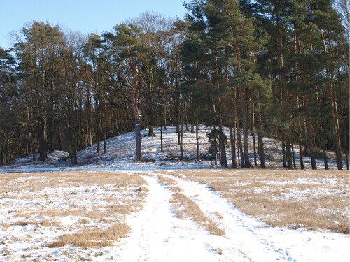
Figure 1. Photograph of the royal tomb (‘Königsgrab’) of Seddin.
2. Materials and methods
Detailed geomorphological field mapping was conducted in an area of 16 km2 around the royal tomb of Seddin. The area was subdivided into 1 km2 grid squares and 1:10,000 topographic maps were used as map basis (LGB, Citation2014; for map sheets see ). Validation was achieved through the integration of high-resolution satellite imagery (<1 m² resolution; DigitalGlobe, Inc.) and a set of derivates of the LiDAR-derived digital elevation model (DEM). The LiDAR DEM (GeoBasis-DE/LGB, Citation2020) has a resolution of 1 m² and a height accuracy of 0.3–0.5 m (LGB, Citation2021).
Table 1. Historical, thematic, and topographic maps considered for the production of the Main Map A, chronologically sorted by the year(s) of production/publication (for further information see Supplementary Material).
The calculation of the DEM derivates (local relief, cumulative viewshed, shaded relief, and slope angle; for details see ) was performed in GrassGIS (GRASS Development Team, Citation2016); exact positioning of features larger than c. 1 m was realized using these derivates. Georeferenced sets of historical, thematic, and topographic maps () complemented the data set (cf. Supplementary Material). Wherever possible, we used the symbology of the German guidelines for geomorphological mapping (Leser & Stäblein, Citation1975); English terminology follows Leser and Stäblein (Citation1985).
Table 2. GRASS modules that were used for calculation of the DEM derivates.
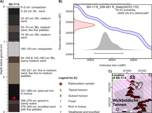
Several vibra corings were conducted between 2015 and 2017; here we present the radiocarbon-dated core SD-17-6 that was obtained from the large depression in the north of the forest ‘Wickboldsche Tannen’ ((C), cf. Main Map A for location). 14C calibration was done with OxCal (v4.4.2; Bronk Ramsey, Citation2009, Citation2020) using atmospheric data from Reimer et al. (Citation2020).
Figure 2. (A) Simplified profile drawing of core SD-17-6 that was obtained from the bottom of the depression in the north of the forest ‘Wickboldsche Tannen’. (B) Calibration of the radiocarbon sample obtained from SD-17-6; dated material was a bulk sample from the peat. (C) Detail of the depression in the north of the forest ‘Wickboldsche Tannen’ (cf. northern part of Main Map A for location) and location of coring SD-17-6 (the map is projected in UTM Zone 33U (EPSG: 32633) and refers to the horizontal reference system ETRS89/WGS84).
3. Results and discussion
3.1. Late Quaternary geology and natural land forming processes
The Quaternary processes areas in the environs of the royal tomb comprise glacial, periglacial, fluvial, aeolian, and anthropogenic processes (Main Map A). The region was last glaciated by the Scandinavian Ice Sheet (SIS) during the younger Saalian (Warthanian) ice advance in marine isotope stage 6 (∼ late MIS 6). Thus, Warthanian deposits form a major part of the surface (Ehlers et al., Citation2011; Lippstreu et al., Citation1997, Citation2015). These deposits mostly consist of till, glaciofluvial sand, and gravel (Main Map B). The glaciofluvial material can reach up to 20 m in thickness and the till of the Warthanian ice advance in the Prignitz area usually has a grey-brown or reddish color and is characterized by a higher clay content compared to older tills (Lippstreu et al., Citation2015). The morphology of the area is typical for an old morainic landscape with its smooth, rather leveled topography (slope angles of the plains mostly range between 0% and 2%, cf., Main Map E). Basically, the landscape is composed of these slightly undulating till and sand plains, which are dissected by creeks and river valleys (Main Map A). The elevation differences between the plains and the valleys range from 10 to 20 m and the plateaus usually rise up to 55–60 m above sea level. The end moraine complex that forms a semi-circle some 8 km south of Seddin marks a longer lasting still stand of the inland ice during the meltdown phase of the Warthanian ice advance (Main Map F).
Direct numerical ages of Warthanian sediments are rare for the wider surroundings of the royal tomb. Lüthgens et al. (Citation2010) obtained optically stimulated luminescence (OSL) ages of Saalian glaciofluvial deposits in the south of Brandenburg (Beelitz, c. 120 km southeast of Seddin), which yielded an age range of 150–130 kyr. This coincides with former age estimates based on stratigraphic and morphostratigraphic correlations (Böse et al., Citation2012; Litt et al., Citation2007). Recently obtained OSL ages from the sandy material used for the construction of the royal tomb yielded among Holocene and mid-Weichselian ages also ages that are associated with the initial deposition of glaciofluvial sand during the Late Saalian (Nykamp et al., Citation2021).
The occurrence of periglacial features is a result of long-lasting periglacial conditions in the Weichselian, during which the area remained ice free (cf. also Main Map F for locations of Weichselian ice margins). The peat that occurs in coring SD-17-6 at 221–266 cm depth was buried by six layers of sand showing varying clast contents and signs of past soil-forming processes ((A)). The radiocarbon sample from the bottom of the peat (258–261 cm depth) yielded an age range of 28,905–28,245 cal BP ((B)). This indicates that the onset of the peat formation occurred at the end of the Middle Pleniglacial (latest MIS 3) probably coinciding with ameliorated climatic conditions during the Greenland Interstadial 4 (Wygal & Heidenreich, Citation2014, and references therein) and that initially the depression probably was formed during the Saalian.
In general, periglacial reworking processes such as gelisolifluction and coversand formation caused the leveling of the smoothly undulating topography of the plains and mass wasting along the slopes (Lippstreu et al., Citation1997; Nagel et al., Citation2003; Main Map B). The formation of coversand along the European sand belt started at the end of the Weichselian Pleniglacial (Kaiser et al., Citation2009; Kasse, Citation2002; Koster, Citation2005); coversand from Beelitz was dated by OSL to c. 15 ka (Lüthgens et al., Citation2010). Soil formation in the region started during the Late Glacial (Kappler et al., Citation2019; Kühn, Citation2003) and Cambisols and Luvisols (according to: IUSS Working Group WRB, Citation2006; termed ‘Braunerde’, ‘podsolige Braunerde’, ‘Fahlerde’, and ‘Braunerde-Fahlerde’ according to Ad-Hoc-AG Boden, Citation2005) have developed in the sandy to loamy-sandy substrates (MLUV, Citation2005a, Citation2005b; GeoBasis-DE/LGB, Citation2012). The valleys are characterized by Gleysols and peat (GeoBasis-DE/LGB, Citation2012).
The study area is drained towards southwest by the Stepenitz river. The confluence of the Stepenitz into the Elbe, which drains into the North Sea, lies c. 23 km to the south close to the city of Wittenberge (Main Map F); the distance to the Baltic coast is c. 90 km. The Stepenitz is a navigable waterway for shoal barges and such boats, usually in the form of dugout canoes, are documented for the Bronze Age. Thus, the Stepenitz represents a possible transportation route between the North Sea, the Elbe, and the ritual landscape of Seddin in the northeastern inland (May & Hauptmann, Citation2011). Within the mapped area (Main Map A) the Stepenitz meanders through a broad floodplain that formed during the Holocene (Nagel et al., Citation2003). Two steps separate the Holocene floodplain from the above-lying terraces that show corresponding heights on both sides of the river. These steps can be clearly identified by their increased slope angles compared to flat surface of the floodplain and the terrace bodies (Main Map E). The Stepenitz transported Weichselian meltwater towards the Elbe glacial spillway (Lutze, Citation2014) and the terraces are probably the product of Late Weichselian fluvial aggradation. The bodies of the terraces are usually dissected by the tributary rivers or creeks (Main Map A).
Aeolian forms usually occur in floodplain areas, but also appear on the slightly undulating till or glaciofluvial plains as a result of periglacial conditions and excessive supply of fine-grained sand. Within the mapped area a single dune-shaped feature occurs in the southern part of the forest ‘Bauerntannen’ (Main Map A), which was also recorded in historic and modern maps (cf., Ministerium des Innern, Verwaltung Vermessungs- und Kartenwesen, Citation1984; Schulte & Wahnschaffe, Citation1905).
3.2. The Late Bronze Age royal tomb within the ritual landscape of Seddin
Due to the monumental dimensions and its isolated position the burial mound must have been widely visible – at least during periods with a sparse tree cover – dominating the slightly undulating morainic landscape (May, Citation2018a). This is confirmed by cumulative viewshed analysis (Main Map C) showing that the remains of the burial mound are highly visible from most locations and the assumed original height of c. 9 m would have further increased its visibility. Palynological evidence from the wetland area ‘Bergsoll’, c. 7.2 km northeast of the royal tomb, points to extensive deforestation around 800 BCE (Jahns, Citation2018). This is also supported by other archives in Brandenburg and Mecklenburg-Western Pomerania that show a simultaneous increase in human activity in the Late Bronze Age compared to earlier periods. A strong human impact on the vegetation and large-scale woodland clearings are documented by increasing frequencies of cereal-type pollen and secondary anthropogenic indicators, strongly decreasing arboreal pollen, and an increase of fire events (Jahns, Citation2015, Citation2018; Kaiser et al., Citation2020).
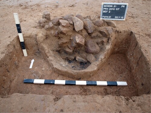
The spatial environs of the royal tomb of Seddin can be understood as a microregion that is roughly confined by two narrow creeks in the north and south and the western bank of the Stepenitz in the east (Main Map A). The nearest known burial mounds in its surroundings have distances of c. 500–600 m. Around 150 pits have been identified c. 50 m north of the royal tomb; they are aligned along a c. 290 m long line with an approximately east–west orientation (Main Map G) and are called stone pit row (‘Steingrubenreihe’; e.g. May, Citation2017, Citation2018a, Citation2018b; May & Hauptmann, Citation2012). The course of this line roughly corresponds to the barely visible local watershed of the creek north of the tomb. The pits mainly contained burnt stones and little charcoal fragments ( and ) providing evidence for ritual practices – probably in the context of death rituals. It is suggested that these activities have occurred for a longer period of time and the stone pit row itself is therefore interpreted as a ritual place (May, Citation2018a, Citation2018b). Food preparation in cooking pits has been excluded due to similar and very low phosphate concentrations inside and around the pits (Hoelzmann & Knitter, Citation2017).
Figure 3. Photograph of a planum showing a part of the excavated stone pit row.
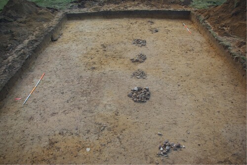
Figure 4. Photograph of an excavated stone pit of the stone pit row.
Radiocarbon datings from the substrate below the royal tomb yielded a terminus post quem age for the construction of the burial mound of 910–800 BCE (May, Citation2018a). This age is also supported by optically stimulated luminescence datings of its construction material (Nykamp et al., Citation2021). The radiocarbon datings obtained from the stone pit row show that the burying of the burnt stones in the pits most probably begun earlier than the construction of the burial mound and terminated at about the same time (May, Citation2018a). Geometrical and astronomical analyses of the stone pit row and the royal tomb also point to a close relationship between both objects. This could imply that the burial mound was built towards the end of the use of this ritual place (May, Citation2018b).
Only diffuse Late Bronze Age settlement structures occur in the close vicinity of the royal tomb and the stone pit row (Main Map A) that might be related to its erection. They mainly occur along the course of the two creeks and the Stepenitz and include areas with floor plans of houses, storage and workshop areas, and other areas from which only surface finds are known (Heske, Citation2019; May, Citation2018a). The detailed study of these structures started in 2015 and first results of the prospection excavations suggest that the settlement between the royal tomb and the burial mounds in the forest ‘Wickboldsche Tannen’ was contemporaneous with these two burial grounds (Heske, Citation2019).
The remains of 96 burial mounds (including the royal tomb) are preserved in the study area. The positions of another 11 tombs are known from historical maps (Main Map A). Presumably, most of these tombs date to the Late Bronze Age (May, Citation2018a). Around one quarter (24) of all burial mounds occur in isolated positions in the landscape; larger concentrations occur in the forest ‘Wickboldsche Tannen’ (39) and on the eastern bank of the Stepenitz (15), west of the village Dannhof as well as two smaller concentrations of eight and six burial mounds in the southern part of the forest ‘Bauerntannen’, west of the village Kreuzburg (Main Map A). Most of the burial mounds can also be identified from the DEM derivates; they have slope angles (Main Map E) mainly ranging between 9% and 18%, locally up to 27%, that stand out from the flat (0–2%) surrounding terrain and rise above their local surface (Main Map D). Urn graves without a burial mound are known from two areas in the forest ‘Wickboldsche Tannen’ and the southern part of the forest ‘Bauerntannen’.
It is suggested that the grave mound field in the forest ‘Wickboldsche Tannen’ originally comprised more than 100 burial mounds (Hauptmann, Citation2006); this would be the largest concentration of burial mounds in the entire Prignitz region. Also, a significant burial mound that already caused a sensation in the year 1888 was rediscovered by excavations in the years 2017 and 2018 in this area. Even though its dimensions are substantially smaller than those of the royal tomb, the burial equipment is quite comparable containing several bronze objects such as a sword, a hatchet, a knife, and a bronze vessel (Götze, Citation1894; May & Hauptmann, Citation2012; Metzner-Nebelsick, Citation2003).
The presence of graves with an exceptionally rich burial equipment such as the aforementioned grave and the royal tomb, together with other richly equipped graves in the surroundings, provides evidence for a strong social stratification among the community of the ‘Seddiner Gruppe’ – in such a way that is not known from other areas in the plains of central and northern Germany (Wüstemann, Citation1974).
The spatial pattern of the cultural remains, i.e. the burial mounds and settlement structures in the surroundings of the royal tomb of Seddin and the stone pit row in its close vicinity (Main Maps A and G), show how this landscape was used and (re-)organized during the Late Bronze Age for economic and ritual purposes.
3.3. Medieval to modern settlement development and land use
Beyond the structures that document anthropogenic landscape modifications during the Late Bronze Age, Main Map A also shows legacies of continued settlement development and land use from medieval to modern times documenting the cultural landscape history of this part of the Prignitz region.
Common morphological features in the mapped area are the ridge and furrow structures that are mainly preserved in forested areas (Main Map A). These structures are a widespread phenomenon in the Prignitz region and beyond whose formation can date back to the Middle Ages (Langewitz et al., Citation2020, Citation2021; MLUV, Citation2005c; Noack, Citation2019). A certain plowing technique, i.e. continuous clockwise plowing in rectangular fields, creates this regularly undulating microtopography with central ridges and peripheral furrows (Alcántara et al., Citation2017). However, also other techniques for their formation, e.g. shovel and spade, are discussed (Langewitz et al., Citation2021). This regularly undulating microtopography is clearly captured by the local relief (Main Map D; a very clear example can be found in the forest ‘Bauerntannen’). The inclined sides of the field strips show slightly increased slope angles (2–3.5%) compared to their mainly flat (0–2%) local surroundings (Main Map E). The ridge and furrow cultivation technique was a common agricultural practice in Europe from medieval times until the nineteenth century CE (Alcántara et al., Citation2017; Langewitz et al., Citation2020, Citation2021). The use of moldboard plows (‘Beetpflug’) since the twelfth or thirteenth century CE allowed to shear off clods from the humic topsoil horizons and turn them over instead of simply scratching the soil with a hook plow (Fries, Citation2005; Raab et al., Citation2016). Recent results dated the beginning of some of these structures in the Altmark region to the seventh century CE, i.e. the Early Middle Ages (Langewitz et al., Citation2020). Draught animals were used to pull the moldboard plow and in order to avoid any unnecessary turning around, long and narrow strip-shaped fields were created close to the villages. As a result of the continuous use of this technique, the typical ridge and furrow microtopography of up several hundred meters length and up to 1 m height developed, because these moldboard plows always turned the clods to the same direction. Field abandonment and afforestation caused the preservation of these structures. However, at most agricultural sites they were leveled due to, e.g. deeper plowing in the late nineteenth and early twentieth century CE (Alcántara et al., Citation2017; Fries, Citation2005; Langewitz et al., Citation2021; Raab et al., Citation2016). Even though numerical age control is lacking for the observed ridge and furrow structures in the mapped area, other examples from Brandenburg and Saxony-Anhalt point to a medieval formation period (Fries, Citation2005; Geldermacher et al., Citation2003; Langewitz et al., Citation2020; Raab et al., Citation2016).
Documentary mention of the villages in the mapped area started in the fourteenth century CE with Seddin that was first mentioned 1352 CE as the street village ‘Cedyn’. 1368 CE the village Groß Retzin was mentioned as ‘maiori Retzin’; 1489 CE it was mentioned that this village was deserted, and a field existed in the local subdistrict (‘Gemarkung’) ‘Groden Retzin’ (Enders, Citation1997). The remains of the deserted village Groß Retzin (Main Map A) suggest that the village was probably founded as a round village (‘Runddorf’ or ‘Rundling’) – a village form that is typical for the region and particularly widespread in the western Prignitz (Schultze, Citation1956). Wolfshagen was first mentioned 1392 CE as the grange (‘Gutshof’) ‘Wulfeshaghen’ followed by the (today deformed) round village Retzin that was first mentioned 1477 CE and the round village Kreuzburg that was first mentioned 1492 CE as ‘Trutzeborgk’ (Enders, Citation1997). 1752 CE it was mentioned that three to four years earlier forest clearing land reclamation was begun in the area of the deserted local subdistrict ‘Groden Retzin’ and the farm (‘Gutshof’) Dannhof was founded as ‘Dannenhoff’ (Enders, Citation1997, Citation2000).
Other morphological features that frequently occur in the mapped area are depressions, which are mainly endorheic. Many of these structures were also recorded in historic and modern maps (cf., Ministerium des Innern, Verwaltung Vermessungs- und Kartenwesen, Citation1984; Reichsamt für Landesaufnahme, Citation1881; Schulte & Wahnschaffe, Citation1905). These features occur at different positions and in different forms: (i) more or less circular pits dug into the undulating plains and (ii) pits that are dug into the hillslopes of valleys, e.g. north of the village Retzin or along the Stepenitz north of the village Kreuzburg (Main Map A). Especially the circular pits on the plains can be clearly identified by comparing the local relief (Main Map D) and the slope angles (Main Map E); they lie below their local surroundings and have steep hillslopes – usually between 18% and 27% and locally up to 36%. It is likely that most, if not all, of these depressions formed as mining pits from where raw materials were extracted. In historic times, mainly from the eighteenth century CE and sometimes until the mid-twentieth century CE, raw materials such as sand, clay, loam, and marl were extracted. This type of raw material mining was not centrally organized but occurred as local peasant mining, e.g. documented for the loess area in the Rhineland (Gerlach, Citation2019). Many of the well-defined circular depressions that are spread across the modern agricultural fields (Main Map A) bottom out in carbonate-rich Late Saalian till. Marl extraction for fertilization of the sandy substrates on arable fields is also documented for the Federal State Brandenburg and the study area alongside with extraction pits for other raw materials such as sand and clay (Enders, Citation1990; Schulte, Citation1905).
During the eighteenth and nineteenth centuries CE the paving of the roads and alleys with cobblestones was implemented in the Federal State Brandenburg; first evidence of road paving from the Uckermark region (NE Brandenburg) date to 1712 CE. Often the work was done by the rural village communities during the winter and mainly fieldstones (‘Lesesteine’) were used for the paving of the roads (Peters, Citation2004). However, also the erratic boulders from burial mounds were reused and caused the partial destruction of the royal tomb of Seddin and ultimately resulted in the discovery of its burial chamber in the year 1899 (May, Citation2018a).
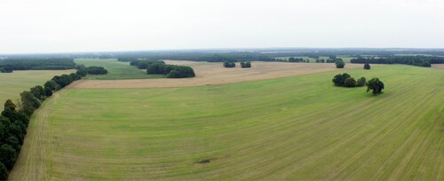
The process of agricultural intensification together with the vast collectivization of farms in East Germany (former GDR) was implemented during 1953–1960. This led to a large-scale homogenization of the landscape through removal of e.g. field roads, field margins, and hedgerows and resulted in a rapid change from small- to large-scale agriculture (Batáry et al., Citation2017). The legacy of this large-scale transformation is clearly visible and characteristic for the present-day landscape in the surroundings of the royal tomb of Seddin ().
Figure 5. Panorama picture of the present-day landscape in the surroundings of the royal tomb created from oblique aerial photographs.
4. Conclusions
Main Map A integrates the classical approach of geomorphological mapping, the documentation of archaeological remains in the Late Bronze Age ritual landscape Seddin, and aspects of settlement development and land use strategies during historic times until the recent past. These lines of evidence illustrate the appearance of the present-day landscape and document the natural and anthropogenic processes that were involved in its shaping. The 106 known burial mounds around the royal tomb of Seddin as well as the stone pit row in its direct vicinity document the (re-)organization of the landscape for ritual purposes during the Late Bronze Age. Due to its isolated location on a slight spur, its enormous dimensions, and the numerous burial mounds in its surroundings the royal tomb has undoubtedly characterized the Late Bronze Age ritual landscape of Seddin. The backdrop in which the burial mounds are placed, the configuration of their locations, and the high visibility of the royal tomb suggest a profound knowledge of the founders for the landscape they lived in.
Software
All raster calculations were conducted in GrassGIS (v. 7.0; GRASS Development Team, Citation2016), the entire cartography was done in ArcMap (10.1), all layers were exported to SVG-files, and the final map layout was realized in Inkscape (v. 0.92).
Supplemental Material
Download PDF (58 MB)Acknowledgements
The three cohorts of students (Bachelors’ project field class; Institute for Geographical Sciences, Department of Earth Sciences, Freie Universität Berlin) are acknowledged for conducting initial geomorphological mapping in the summer terms 2015, 2016, and 2017. We thank Heike Apps, Ulrich Veit, and Filippo Brandolini for reviewing our manuscript and map, for their positive evaluation, and valuable comments that helped to improve this study.
Disclosure statement
No potential conflict of interest was reported by the author(s).
Data availability
The data that support the findings of this study are openly available. All details on source, copyright, and license are provided in the Supplementary Material of this article.
Additional information
Funding
References
- Ad-Hoc-AG Boden. (2005). Bodenkundliche Kartieranleitung. Schweizerbart.
- Alcántara, V., Don, A., Well, R., & Nieder, R. (2017). Legacy of medieval ridge and furrow cultivation on soil organic carbon distribution and stocks in forests. Catena, 154, 85–94. https://doi.org/10.1016/j.catena.2017.02.013
- Batáry, P., Gallé, R., Riesch, F., Fischer, C., Dormann, C. F., Mußhoff, O., Császár, P., Fusaro, S., Gayer, C., Happe, A.-K., Kurucz, K., Molnár, D., Rösch, V., Wietzke, A., & Tscharntke, T. (2017). The former iron curtain still drives biodiversity– profit trade-offs in German agriculture. Nature Ecology & Evolution, 1(9), 1279–1284. https://doi.org/10.1038/s41559-017-0272-x
- Böse, M., Lüthgens, C., Lee, J. R., & Rose, J. (2012). Quaternary glaciations of Northern Europe. Quaternary Science Reviews, 44, 1–25. https://doi.org/10.1016/j.quascirev.2012.04.017
- Bronk Ramsey, C. (2009). Bayesian analysis of radiocarbon dates. Radiocarbon, 51(1), 337–360. https://doi.org/10.1017/S0033822200033865
- Bronk Ramsey, C. (2020). OxCal (Version 4.4.2). https://c14.arch.ox.ac.uk/oxcal.html
- Ehlers, J., Grube, A., Stephan, H.-J., & Wansa, S. (2011). Pleistocene glaciations of north Germany–new results. In J. Ehlers, P. L. Gibbard, & P. D. Hughes (Eds.), Quaternary glaciations – extent and chronology. A closer look. Developments in Quaternary science (pp. 15). Elsevier.
- Enders, L. (1990). Produktivkraftentwicklung und Machtverhalten. Die Agrarproduzenten der Uckermark im 18. Jh. Jahrbuch für Wirtschaftsgeschichte 3, 81–105.
- Enders, L. (1997). Historisches Ortslexikon für Brandenburg. Teil I. Prignitz. Verlag Hermann Böhlhaus Nachfolger, Weimar.
- Enders, L. (2000). Die Prignitz. Geschichte einer kurmärkischen Landschaft vom 12. bis zum 18. Jahrhundert. Verlag für Berlin-Brandenburg, Potsdam.
- Fries, J. E. (2005). Auf schmaler Grundlage. Ein kleines Gewann mit Wölbäckern in der Gemarkung Groß Lieskow bei Cottbus. Arbeitsberichte zur Bodendenkmalpflege in Brandenburg, 14, 87–89.
- Geldermacher, K., Woithe, F., & Rösler, H. (2003). Die Dokumentation von Bodendenkmalen und Archivböden im Niederlausitzer Braunkohlerevier. Petermanns Geographische Mitteilungen, 147(3), 44–49.
- GeoBasis-DE/LGB. (2012). Bodenübersichtskarte des Landes Brandenburg 1:300 000. http://www.geo.brandenburg.de/boden/
- GeoBasis-DE/LGB. (2020). Digitales Geländemodell. https://data.geobasis-bb.de/geobasis/daten/dgm/xyz/
- Gerlach, R. (2019, February). Eine durchlöcherte Landschaft … “ Lehm- und Mergelgruben im Rheinland. Entstehung, Erkennung, archäologische Bedeutung. In T. Raab, A. Raab, & F. Schopper (Eds.), Erfassung und Bewertung von vorindustriellen Meilerstandorten - Workshop 19. Geopedology and Landscape Development Research Series 8, (pp. 71–97). Verlag Brandenburg University of Technology Cottbus-Senftenberg.
- Götze, A. (1894). Hügelgräber bei Seddin. Kreis Westprignitz. Nachrichten über deutsche Altertumsfunde, 11, 82–89.
- GRASS Development Team. (2016). Geographic resources analysis support system (GRASS) software (Version 7.0). Open Source Geospatial Foundation. Electronic document: http://grass.osgeo.org
- GRASS Development Team. (2021a). Addon r.local.relief Geographic resources analysis support system (GRASS) software (Version 7.8). https://grass.osgeo.org/grass78/manuals/addons/r.local.relief.html
- GRASS Development Team. (2021b). Addon r.param.scale. Geographic resources analysis support system (GRASS) software (Version 7.8). https://grass.osgeo.org/grass78/manuals/r.param.scale.html
- GRASS Development Team. (2021c). Addon r.viewshed. Geographic resources analysis support system (GRASS) software (Version 7.8). https://grass.osgeo.org/grass78/manuals/r.viewshed.html
- Haburaj, V., Nykamp, M., May, J., Hoelzmann, P., & Schütt, B. (2020). On-site VIS-NIR spectral reflectance and colour measurements – a fast and inexpensive alternative for delineating sediment layers quantitatively? A case study from a monumental Bronze Age burial mound (Seddin, Germany). Heritage, 3(2), 528–548. https://doi.org/10.3390/heritage3020031
- Hauptmann, T. (2006). Das Gräberfeld in den Wickboldschen Tannen bei Seddin Lkr. Prignitz 1888/2006, Aktenrecherche und Teilvermessung, unveröffentlichter Bericht 2006.
- Heske, I. (2019). Zwischen Königsgrab und Wickbold 1 — Jungbronzezeitliche Siedlungsreste bei Seddin in der Prignitz. Vorbericht über die Prospetkionsgrabungen der Jahre 2015 bis 2018. Praehistorische Zeitschrift, 94(1), 210–232. https://doi.org/10.1515/pz-2019-0009
- Hoelzmann, P., & Knitter, D. (2017). König Hinz und Königswasser. Geowissenschaft am “Königsgrab” von Seddin, Lkr. Prignitz. In: Archäologische Gesellschaft in Berlin und Brandenburg e.V. (Ed.), Archäologie in Berlin und Brandenburg 2015 (pp. 52–55). Konrad Theiss Verlag.
- IUSS Working Group WRB. (2006). World reference base for soil resources 2006. World Soil Resources Reports No. 103. FAO.
- Jahns, S. (2015). Bronze Age settlements reflected in pollen diagrams from Brandenburg, Eastern Germany. In J. Kneisel, M. Dal Corso, W. Kirleis, H. Scholz, N. Taylor, & V. Tiedtke (Eds.), The third food revolution? Setting the Bronze Age table: Common trends in economic and subsistance strategies in Bronze Age Europe (pp. 237–248). Habelt.
- Jahns, S. (2018). Pollenanalytische Untersuchungen zur Bronzezeit am Bergsoll bei Helle, Lkr. Prignitz. In Hansen, S. & Schopper, F., (Eds.), Der Grabhügel von Seddin im norddeutschen und südskandinavischen Kontext. Arbeitsberichte zur Bodendenkmalpflege in Brandenburg 33. Brandenburgisches Landesamt für Denkmalpflege und Archäologisches Landesmuseum, Wünsdorf, (pp. 85–90).
- Kaiser, K., Hilgers, A., Schlaak, N., Jankowski, M., Kühn, P., Bussemer, S., & Przegiętka, K. (2009). Palaeopedological marker horizons in northern central Europe: Characteristics of Lateglacial Usselo and Finow soils. Boreas, 38(3), 591–609. https://doi.org/10.1111/j.1502-3885.2008.00076.x
- Kaiser, K., Schneider, T., Küster, M., Dietze, E., Fülling, A., Heinrich, S., Kappler, C., Nelle, O., Schult, M., Theuerkauf, M., Vogel, S., de Boer, A. M., Börner, A., Preusser, F., Schwabe, M., Ulrich, J., Wirner, M., & Bens, O. (2020). Palaeosols and their cover sediments of a glacial landscape in northern central Europe: Spatial distribution, pedostratigraphy and evidence on landscape evolution. Catena, 193, 104647. https://doi.org/10.1016/j.catena.2020.104647
- Kappler, C., Kaiser, K., Küster, M., Nicolay, A., Fülling, A., Bens, O., & Raab, T. (2019). Late Pleistocene and Holocene terrestrial geomorphodynamics and soil formation in northeastern Germany: A review of geochronological data. Physical Geography, 40(5), 405–432. https://doi.org/10.1080/02723646.2019.1573621
- Kasse, C. (2002). Sandy aeolian deposits and environments and their relation to climate during the last glacial maximum and Lateglacial in northwest and central Europe. Progress in Physical Geography: Earth and Environment, 26(4), 507–532. https://doi.org/10.1191/0309133302pp350ra
- Koster, E. A. (2005). Recent advances in luminescence dating of Late Pleistocene (cold-climate) aeolian and loess deposits in Western Europe. Permafrost and Periglacial Processes, 16(1), 131–143. https://doi.org/10.1002/ppp.512
- Kühn, P. (2003). Micromorphology and Late glacial/Holocene genesis of Luvisols in Mecklenburg–Vorpommern (NE-Germany). Catena, 54(3), 537–555. https://doi.org/10.1016/S0341-8162(03)00129-2
- Langewitz, T., Fülling, A., Klamm, M., & Wiedner, K. (2020). Historical classification of ridge and furrow cultivation at selected locations in northern and central Germany using a multi-dating approach and historical sources. Journal of Archaeological Science, 123, 105248. https://doi.org/10.1016/j.jas.2020.105248
- Langewitz, T., Wiedner, K., Polifka, S., & Eckmeier, E. (2021). Pedological properties related to formation and functions of ancient ridge and furrow cultivation in central and northern Germany. Catena, 198, 105049. https://doi.org/10.1016/j.catena.2020.105049
- Leser, H., & Stäblein, G. (1975). Geomorphologische Kartierung. Richtlinien zur Herstellung geomorphologischer Karten 1:25.000. Berliner Geographische Abhandlungen, Sonderheft.
- Leser, H., & Stäblein, G. (1985). Legend of the geomorphological map 1:25.000 (GMK 25) – fifth version in the GMK priority program of the Deutsche Forschungsgemeinschaft – Berliner Geographische Abhandlungen 39, 61–89.
- LGB (Landesvermessung und Geobasisinformation Brandenburg). (2006a). Schmettausches Kartenwerk 1:50,000. Blatt: Brandenburg-Sektion 36, Pritzwalck (1767–1787).
- LGB (Landesvermessung und Geobasisinformation Brandenburg). (2006b). Preußische Kartenaufnahme 1:25,000 – Uraufnahme – Blatt: 2838 Wolfshagen (1825).
- LGB (Landesvermessung und Geobasisinformation Brandenburg). (2007). Preußische Kartenaufnahme 1:25,000 – Uraufnahme – Blatt: 2837 Baek (1843).
- LGB (Landesvermessung und Geobasisinformation Brandenburg). (2014). Topographische Karte 1:10,000. Blätter: 2837-N0 Tangendorf, 2837-SO Retzin, 2838-NW Helle, 2838-SW Groß Pankow.
- LGB (Landesvermessung und Geobasisinformation Brandenburg). (2021). Geländemodell. https://geobasis-bb.de/lgb/de/geodaten/3d-produkte/gelaendemodell/
- Lippstreu, L., Hermsdorf, N., & Sonntag, A. (1997). Geologische Übersichtskarte des Landes Brandenburg 1:300 000. Landesamt für Geowissenschaften und Rohstoffe Brandenburg, Potsdam.
- Lippstreu, L., Hermsdorf, N., Sonntag, A., & Strahl, J. (2015). Saale-Hochglazial: In: Stackebrandt, W. & Franke & D., (Eds.), Geologie von Brandenburg. E. Schweizerbart’sche Verlagsbuchhandlung.
- Litt, T., Behre, K.-E., Meyer, K.-D., Stephan, H.-J., & Wansa, S. (2007). Stratigraphical terms for the Quaternary of the North German glaciation area. E&G Quaternary Science Journal, 56(1–2), 7–65. https://doi.org/10.3285/eg.56.1-2.02
- Lüthgens, C., Böse, M., & Krbetschek, M. (2010). On the age of the young morainic morphology in the area ascribed to the maximum extent of the Weichselian glaciation in north-eastern Germany. Quaternary International, 222(1–2), 72–79. https://doi.org/10.1016/j.quaint.2009.06.028
- Lutze, G. (2014). Naturräume und Landschaften in Brandenburg und Berlin. Gliederung, Genese und Nutzung. Be-Bra Wissenschaft Verlag.
- May, J. (2017). Das “Königsgrab” von Seddin. Archäologie, Denkmalschutz und Tourismus 2012 bis 2015. In: Archäologische Gesellschaft in Berlin und Brandenburg e.V., (Ed.), Archäologie in Berlin und Brandenburg 2015, (pp. 44–50). Konrad Theiss Verlag.
- May, J. (2018a). Neue Forschungen am “Königsgrab” von Seddin. In: Hansen, S. & Schopper, F., (Eds.), Der Grabhügel von Seddin im norddeutschen und südskandinavischen Kontext. Arbeitsberichte zur Bodendenkmalpflege in Brandenburg 33. Brandenburgisches Landesamt für Denkmalpflege und Archäologisches Landesmuseum, Wünsdorf, (pp. 9–35).
- May, J. (2018b). Fokussieren, Positionieren, Schritthalten. Aspekte von Raum und Zeit am “Königsgrab” von Seddin in der Prignitz. In: Aufleger, M. & Tutlies, T., (Eds.), Das Ganze ist mehr als die Summe seiner Teile. Festschrift für Jürgen Kunow anlässlich seines Eintritts in den Ruhestand. Materialien zur Bodendenkmalpflege im Rheinland 27, (pp. 405–418).
- May, J., & Hauptmann, T. (2011). Warum befindet sich das “Königsgrab” von Seddin am Mittellauf der Stepenitz? Wasserwege und archäologische Sachkultur der jüngeren Bronzezeit in der Prignitz. In F. Bittmann, J. Ey, M. Karle, H. Jöns, E. Strahl, & S. Wolters (Eds.), Flüsse als Kommunikations- und Handelswege (pp. 129–150). Verlag Marie Leidorf.
- May, J., & Hauptmann, T. (2012). Das “Könisggrab” von Seddin und sein engeres Umfeld im Spiegel neuer Feldforschungen. In: Bérenger, D., (Ed.), Gräberlandschaften der Bronzezeit. Bodenaltertümer Westfalens, 51. Philipp von Zabern, (pp. 77–104).
- Metzner-Nebelsick, C. (2003). Das “Königsgrab” von Seddin in seinem europäischen Kontext. In: Kunow, J., (Ed.), Das “Königsgrab” von Seddin in der Prignitz. Kolloquium anlässlich des 100. Jahrestages seiner Freilegung am 12. Oktober 1999. Arbeitsberichte zur Bodendenkmalpflege in Brandenburg 9, (pp. 35–60).
- Ministerium des Innern, Verwaltung Vermessungs- und Kartenwesen. (1984). Topographische Karte 1:10,000. Blätter: 0605-422 Seddin, 0605-424 Retzin, 0606-311 Wolfshagen, 0606-313 Groß Pankow.
- MLUV (Ministerium für Ländliche Entwicklung, Umwelt und Verbraucherschutz). (2005a). Braunerde. Steckbriefe Brandenburger Böden. https://mluk.brandenburg.de/Steckbriefe-BB-Boeden/a_sb_4_1.pdf
- MLUV (Ministerium für Ländliche Entwicklung, Umwelt und Verbraucherschutz). (2005b). Braunerde-Fahlerde. Steckbriefe Brandenburger Böden. https://mluk.brandenburg.de/Steckbriefe-BB-Boeden/a_sb_5_3.pdf
- MLUV (Ministerium für Ländliche Entwicklung, Umwelt und Verbraucherschutz). (2005c). Wölbäcker. Steckbriefe Brandenburger Böden. https://mluk.brandenburg.de/media_fast/4055/a_sb_8_2.pdf
- Nagel, D., Hermsdorf, N., Lippstreu, L., & Martiklos, G. (2003). Geologische Übersichtskarte 1:200,000. Blatt: CC 3134 Wittenberge. Bundesanstalt für Geowissenschaften und Rohstoffe (BGR), Hannover.
- Noack, D. (2019). GIS-gestützte Analyse zum Wölbäckervorkommen in der Prignitz. Journal für Angewandte Geoinformatik, 5, 60–72.
- Nykamp, M., Hardt, J., Hoelzmann, P., May, J., & Reimann, T. (2021). Towards timing and stratigraphy of the Bronze Age burial mound royal tomb (Königsgrab) of Seddin (Brandenburg, northeastern Germany). E&G Quaternary Science Journal, 70(1), 1–17. https://doi.org/10.5194/egqsj-70-1-2021
- Peters, J. (2004). Alleen und Pflasterstraßen als kulturelles Erbe. Entwicklungsgeschichte und heutige Bedeutung am Beispiel der Mark Brandenburg. UVP-report, 18(2–3), 105–109.
- Raab, T., Raab, A., Nicolay, A., Takla, M., Hirsch, F., Rösler, H., & Bauriegel, A. (2016). Opencast mines in South Brandenburg (Germany)—archives of Late Quaternary landscape development and human-induced land use changes. Archaeological and Anthropological Sciences, 8(3), 453–466. https://doi.org/10.1007/s12520-015-0227-6
- Reichsamt für Landesaufnahme. (1881). Königl. Preuss. Landes-Aufnahme 1:25,000. Blätter: 1390 Baeck and 1391 Gr. Pankow (1879).
- Reimer, P., Austin, W., Bard, E., Bayliss, A., Blackwell, P., Bronk Ramsey, C., Butzin, M., Cheng, H., Edwards, R., Friedrich, M., Grootes, P., Guilderson, T., Hajdas, I., Heaton, T., Hogg, A., Hughen, K., Kromer, B., Manning, S., Muscheler, R., … Talamo, S. (2020). The IntCal20 northern hemisphere radiocarbon age calibration curve (0–55 cal kBP). Radiocarbon, 62(4), 725–757. https://doi.org/10.1017/RDC.2020.41
- Schulte, L. (1905). Geologische Spezialkarte von Preussen und den Thüringischen Staaten: Bäk – Erläuterungen. Königliche Preussische Geologische Landesanstalt, Berlin.
- Schulte, L., & Wahnschaffe, F. (1905). Geognostisch Agronomische Karte 1:25,000. Blatt: 2837 Bäk (1900–1901). Königliche Preussische Geologische Landesanstalt.
- Schultze, J. (1956). Die Prignitz. Aus der Geschichte einer märkischen Landschaft. Böhlau Verlag.
- Wüstemann, H. (1974). Zur Sozialstruktur im Seddiner Kulturgebiet. Zeitschrift für Archäologie, 8, 67–107.
- Wygal, B. T., & Heidenreich, S. M. (2014). Deglaciation and human colonization of Northern Europe. Journal of World Prehistory, 27(2), 111–144. https://doi.org/10.1007/s10963-014-9075-z