
ABSTRACT
This article presents the geomorphological mapping of the Kalamas river delta in Thesprotia (Epirus, north-western Greece). The Kalamas (also known as Thyamis) is one of the three main deltas of this region. Detailed mapping was performed through analysis of field geomorphological surveys and interpretation of old maps, satellite images, aerial photos, and DEM. The evolution of the delta as well as its current morphology derives from complex interactions between alluvial, marine dynamics and human activities. Several palaeo-channels have been identified, and the recent morphology of the delta has been altered by the construction of a dam and the canalization of the river during the second half of the twentieth century. The coastline is complex, and mainly consists of lagoons, sandy barriers and sand spits. Since part of the delta has been prograding for about fifty years, the current dynamics indicate erosion as well as progressive submersion of these low coasts.
1 Introduction
Deltas are particular coastal and submarine geomorphological forms. An interface between land and sea, deltas are the result of the Holocene sedimentary history that spans nearly 8,000 years. Low-altitude and mostly fertile areas, they have been occupied for several millennia (CitationFouache, Citation2006). In Greece, a predominantly mountainous country, they are now areas with high economic value, particularly for the agricultural sector. Their sedimentary processes are complex, and it is always difficult to distinguish them as they are interdependent. Climate, tectonics, river and marine dynamics, but also land use and human activities are all factors contributing to their characterization as objects of study in geosciences (CitationAnthony, Citation2015; CitationGaki-Papanastassiou et al., Citation2011).
Located at the outlet of a multitude of rivers, deltas are common coastal formations in Greece. Their Holocene evolution is fairly well-studied, and their archaeological value is well-established (CitationAnthony et al., Citation2014; CitationBrückner et al., Citation2005; CitationGhilardi et al., Citation2008). These interface areas have been intensely crossed and occupied since the Palaeolithic era. Combining various resources essential to the survival of human groups (ease of access, fresh water, etc.), they have been refuge areas at different times, such as during the last Ice Age (CitationBailey & Flemming, Citation2008; CitationLambeck, Citation1996). However, there is often an astonishing paradox to this very old and continuous frequentation: there generally aren’t many archaeological remains on the surface. The study of past and present environmental dynamics, as well as their mapping, provides a better understanding of the presence or absence of archaeological remains in these coastal areas.
Eastward from the island of Corfu on the Ionian coast, the Kalamas delta is located downstream of a medium-sized river with permanent flow. It is one of the three deltaic areas in Epirus, along with the Acheron and the Arachtos-Louros river deltas (CitationBesonen et al., Citation2003; CitationKapsimalis et al., Citation2005). Occupied since the Neolithic era and currently classified as a Natura 2000 area, this delta has not yet been the subject of a study focusing on geomorphological mapping. The morphology of this delta is atypical and even unique in Greece: it is the consequence of particular alluvial and marine dynamics, as well as twentieth century anthropogenic activities.
Furthermore, this study gains significance since it investigates an area endangered due to the human activity of the last sixty years and the global sea-level rise (CitationGaki-Papanastassiou et al., Citation1997; CitationMertzanis et al., Citation2013; CitationPoulos et al., Citation2009).
This study and the geomorphological mapping of the Kalamas river delta fill the gap that existed in the geomorphology of Ionian coastline deltas in Greece.
1.1 Location and physiography of the delta
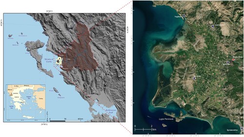
The Kalamas river delta is the northernmost of the deltas on the Ionian coast and is located close to the border with Albania, in a region called Epirus (). With a surface area of approximately 85 km², it is an atypical delta. Its shape corresponds to that of an ‘arcuate’ type delta. The front consists of sandy beaches and long sandy spits, associated with very low tidal range (+/- 30 cm) and morphogenic coastal dynamics, indicating that the fluvial dominance is evident in the history of its construction (CitationGaki-Papanastassiou et al., Citation2011). However, recent developments as well as the construction of a dam upstream of the delta have significantly changed its appearance. The current man-induced mouth of the Kalamas is more akin to a ‘bird's foot’ type mouth, probably due to the remobilization and redistribution of old alluvial and deltaic sediments.
Figure 1. Location of the study area (image © Zoom Earth, Microsoft).
The conditions necessary for the formation of the Kalamas river delta are the same as for any other delta in Greece: a favourable regional climate which allows for significant rainfall, a watershed whose lithology presents a high erosive potential and a steep topography which facilitates the erosion processes (CitationKarymbalis & Gaki-Papanastasiou, Citation2008). Furthermore, the Kalamas river delta has a particular and defining characteristic: it was developed in the Straits of Corfu, sheltered from the strong prevailing currents of the Ionian Sea (CitationPapathanassiou & Zenetos, Citation2005; CitationSimboura et al., Citation2019). The basin in which it extends has a regular and gently sloping submarine topography, which has enabled the accumulation of stream sediments and the progradation of the delta for several millennia (CitationPerissoratis & Conispoliatis, Citation2003).
Like most of the low-lying areas of Greece, the delta has undergone major development works during the twentieth century with the purpose of draining this land and making it easier to cultivate (CitationKarymbalis et al., Citation2016; CitationMaroukian & Karymbalis, Citation2004).
1.2 The river in its watershed
The Kalamas is, along with the Acheron, Arachtos and Louros rivers, one of the four perennial streams of Epirus. Approximately 115 kilometres long, its average annual flow fluctuates around 38.6 m3/sec, with apparent disparities depending on the season (CitationLekka et al., Citation2004; CitationNikolaou, Citation2010; CitationNtoanidis, Citation2015). Upstream of the delta, this flow is now controlled by a hydroelectric dam built in 1962. The sustainability of the watercourse is ensured by seasonal and significant precipitation over the mountain range of Epirus as well as by highly-developed karst processes (CitationKazakis et al., Citation2018; CitationNikolaou, Citation2010). Indeed, Epirus is one of the wettest regions in mainland Greece. Several meteorological stations located in the river basin measure annual rainfall of between 1,100 and 1,800 mm/year, with marked disparities between the summer and winter months (CitationNikolaou, Citation2010).
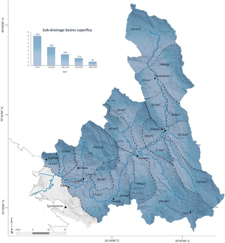
The catchment area covers nearly 1,750 km². Its lithology is composed mainly of sedimentary rocks (limestones and flyschs as well as a few gypsum mounts) and detrital (conglomerates, breccia and finer alluvial sediments) which belong to the Ionian zone (CitationIGRS-IFP, 1966) (General Map). The modest size of the sub-watersheds (almost half have an area of less than 50 km²) is attributed to the clear partitioning of the rugged terrain: the Kalamas circulates through numerous gorges and narrow, steep-sided valleys, the ridges of which easily exceed the altitude of a thousand metres (CitationAubouin, Citation1959) (). The area of the delta is relatively small compared to the extent of the watershed, which is partly explained by the tectonic activity: the Kalamas passes through a succession of cross valleys and grabens (including the two most important, the basins of Neraida and Vrisella) which acted as sedimentary traps during the Quaternary (CitationBousquet, Citation1976; CitationNtokos, Citation2017; CitationWaters, Citation1994) (General map). Most of the coarse solid load in the river is therefore accumulated upstream of the delta. The suspended load is seasonally varying and different for the wet and dry season. The erosivity is higher during dry season rainfall (CitationMimikou, Citation1982). Since the construction of the dam in 1962, the delta has been deprived of sediment supply, which has had a strong impact on the erosion processes of the coastline.
Figure 2. Sub-drainage basins of the Kalamas river.
1.3 Historical occupation and land-use changes in the delta
Human occupation of the delta can be traced back at least to the Bronze Age, with an increase in importance during Antiquity (CitationDakaris, Citation1972; CitationVassiliadis, Citation2008). Three main archaeological sites have been discovered in the area (General map): the fortress of Pyrgos Ragiou, located at the top of a rocky hill, was inhabited from the Bronze Age until the Ottoman period (CitationKanta-Kitsou, Citation2009); Mastilitsa hill, at the top of which the ruins of an archaic temple have been found (CitationKanta-Kitsou, Citation2008); and finally, the Lygia peninsula, which was inhabited during the classical and Hellenistic periods and which probably had a port. These three settlements share the distinctive feature of being located high on hills, protected from the sedimentary dynamics of the delta. Ever-changing sedimentary dynamics make any archaeological research in the delta challenging, as many archaeological sites have either been destroyed or buried deeply under the alluvium of the river (CitationChabrol et al., Citation2012). Therefore, it is highly likely that a large part of the history of occupation of the Kalamas delta is unknown to archaeologists today (CitationChristophilopoulou, Citation2002; CitationHammond, Citation1967). In more recent history, the coastal area was a centre of salt production, especially in Sagiada, and remained so over the course of several centuries. During the twentieth century, extensive drainage and irrigation works, associated with the construction of the Ragio dam in 1962, were carried out in order to expand the agricultural area and reduce flooding (CitationKrina et al., Citation2020). Nowadays, this agricultural area is devoted to fruit production.
2 Methodology
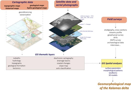
Landscape mapping is a multi-step process, ranging from an inventory of available cartographic and environmental sources to field surveys (CitationJames et al., Citation2012; CitationGens, Citation2010). In our case, the mapping of the superficial deposits, margins and coastline of the delta hinges on various research methods commonly used in field geomorphology, geoarchaeology and history. The pooling of these data and their spatialisation was made possible by the creation of a GIS project (ArcGis 10 and GlobalMapper), which was updated and completed on a regular basis at the end of each survey ().
Figure 3. Methodological diagram showing the mapmaking method.
2.1 Primary thematic layers with analogue maps and aerial pictures
Basic topographic information was obtained from several maps. 1:50,000 scale maps of the Thesprotia region and 1/5000 scale sheets of the delta (Hellenic Military Geographical Service) were used for the sake of the study. The geological and hydrogeological maps, obtained from the IGME (Institute of Geology and Mineral Exploration) and from the IFP (Institut Français du Pétrole) are quite old (1960s) and not very precise as regards the most recent formations, namely those of the Pleistocene and the Holocene (CitationIGME, Citation1967, Citation1969). However, they provide a good general geological framework. Numerous aerial photos dating from 1945, 1961, 1969, 1981 and 1995 have also been orthorectified, georeferenced and integrated into the GIS project.
These maps and aerial photographs enabled the vectorization of coastlines, rivers, geological layers, contour lines and isobaths.
Finally, a variety of old maps were also utilized: a physical map from 1826 (CitationLapie, Citation1826), maps of the Austro-Hungarian Empire from 1896 and a map of the German army from 1914. Les cartes anciennes sont indispensables. The Epirus coast is an area that has been mapped since medieval times: the significance of the island of Corfu in the Mediterranean maritime trade made coastal mapping essential. Evidently, the older the maps, the lower their accuracy. However, they provide valuable information, particularly on the location of coastal rivers as well as on toponyms that have now been forgotten. Travelers’ accounts can also sometimes be useful, such as those of François Pouqueville at the beginning of the nineteenth century (CitationPouqueville, Citation1826).
2.2 Remote sensing data
The processing of satellite images (Quickbird and Landsat) makes it possible to highlight the wetlands by contrast and to make hypotheses about the hydrological dynamics of the delta (CitationPetropoulos et al., Citation2015). Their combination with georeferenced and very-high-resolution images obtained using Google Earth is highly effective. Digital elevation data was obtained using ALOS-PALSAR Digital Elevation Models. These high-resolution topographic data from the Japanese satellite ALOS, uploaded in 2019 and initially intended to help research on environmental risks, provide a resolution of 20 metres — a resolution that allows us to map the low coastal areas properly. This spatial resolution is particularly useful for mapping very low areas, such as coastal marshes. Classified contour lines (every 2 metres) make it possible to map old or abandoned channels. The creation of slope maps using Spatial Analyst tools is essential because it highlights many geomorphological forms which are characterized by their slope (alluvial fans, debris, contact zones, etc.) (CitationVandarakis, Liosis, and Pavlopoulos, Citation2013).
2.3 Field surveys
Various field surveys allowed for a specification of the geomorphological objects and a precise mapping of their extent. Field surveys are particularly useful for verifying observations made on satellite and aerial images (CitationVandarakis, Liosis, & Pavlopoulos, Citation2013). The Kalamas as well as the intermittent rivers on its borders were explored on foot, and any modification in their dynamics or their type of sedimentation was georeferenced. The study of the plot and its orientation enabled us to accurately define the extent of the alluvial fans. Two drilling and geophysical surveys indicated the types of sedimentary deposits as well as the location of the palaeo-channels. As the coast is often inaccessible (due to extensive swamp areas and lack of paths), high-resolution photographs obtained by drone at low altitude allowed the specification of its morphology. Finally, and whenever possible, we collected the information given by the farmers, particularly concerning the water resource (depth, position, quality) or the spatial organization of agricultural plots according to the types of soil.
2.4 Mapping geomorphological features
All the geographic entities appearing on the map follow established rules of mapping: each of them corresponds to a symbol, a figure or an attribute-driven colour. The colours of the geological layers correspond to those recommended by the International Commission on Stratigraphy and are classified in chronological order in the accompanying legend. Similarly, the symbols used to represent geomorphological features follow previously-published standards (Pavlopoulos et al., Citation2009; CitationSmith et al., Citation2011). In certain cases, new symbols have been adopted, particularly concerning the coastline.
3 Results
The northern edge of the delta is mainly composed of Eocene limestone and Miocene conglomerates while the eastern edge is composed of Triassic breccias. Erosion is therefore intensive in these areas and many intermittent torrents also contribute to the sedimentation processes in the delta (CitationPoulos & Chronis, Citation1997). Alluvial fans are located at the edge of the deltaic plain and at the entrance of the Kalamas in the delta, indicating the probable existence of a large syn-sedimentary fault (CitationIGRS-IFP, 1966; CitationNtokos, Citation2017, Citation2018; CitationWaters, Citation1994).
The study identified and mapped several landforms that fall into two categories based on their geomorphological dynamics: alluvial and coastal. It also highlights an atypical deltaic front composed of two different mouths: one, active today, which has a wave-river dominated morphology; one further south which is now inactive and has a typical river-dominated morphology, but is sheltered behind sandspits that reflect wave-reworking.
3.1 Map composition
The final map consists of six parts. A table summarizes the main hydrological and hydrogeomorphological characteristics of the river, its watershed and its delta. A geological cross-section, the orientation of which corresponds to what is indicated in the main map, allows for the interpretation of the geological stratigraphy of the delta and its surrounding area. This cross-section was created using geological maps from IGME and IFP. In addition, two regional maps show the extent of the Kalamas watershed as well as its lithology. In the legend, this lithology has been classified into four main groups: limestone rocks, flysch, evaporites and alluvial sediments. Finally, the geomorphological map of the delta, whose legend distinguishes the coastal landforms and processes and the hydrological and deltaic dynamics, summarizes the key findings of the study. The accompanying ‘Topography and bathymetry’ section lists all the elements necessary to comprehend the altitude and the land use of the area. Geographic coordinates are provided in UTM WGS84, a system that differs from the Greek ΕΓΣΑ'87.
3.2 Alluvial and colluvial landforms
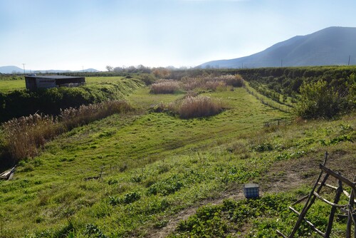
The load of the Kalamas in the delta consists mainly of fine deposits (sands, silts and clays). The coarser alluvium is deposited by the river in two depressions located just before the delta and currently used for gravel mining. Prior to the dam construction in 1962, the Kalamas river formed a large deltaic fan with gently sloping topography well observed in aerial photos. As in many Mediterranean deltaic plains, the course of the Kalamas in its delta has significantly changed (CitationMaroukian et al., Citation1995). Prior to 1962, the mouth of the river was located to the southwest, between the hill of Mavron-Oros and the Lygia peninsula (CitationKarymbalis et al., Citation2006). In addition, its meandering course often changed due to successive floods, which made the plain inaccessible to farmers. Some palaeo-channels are still observable on aerial images but also on the ground: accretion point bar ridges are visible in the convex part of the abandoned meanders. Aerial photos from 1945 reveal large parts of the delta that are regularly flooded, especially to the south and east, forming several square-kilometres of swamps. Infrared satellite images reveal the existence of palaeo-channels near the hill of Pyrgos Raghiou as well as at the level of the old mouth between Mavron-Oros and Lygia. The construction of the dam in 1962 directed the course of the Kalamas which now passes in a straight line between the hills of Mavron-Oros and Mastilitsa. Today, bordered by wide embankments, its old meanders, some of which are cutoff, have been dried out and gradually repurposed for agriculture (). The sedimentary dynamics appear to be different in the northern part, between the Mastilitsa hill and the village of Asproklisi. It is likely that the main course of the Kalamas never reached that area. On the other hand, old maps show a very different alluvial configuration in the nineteenth century. The village of Asproklisi is located upstream of a more or less indurated and incised torrential fan. A map from 1826 clearly depicts that this torrent continued its course in the plain and reached the sea south of Sagiada. The infrared satellite images reveal what could be an old filled channel. At the end of the nineteenth century and at the beginning of the twentieth century, this torrent seems to join the old course of the main river south of Mastilitsa. In general, the contact between torrential and deltaic deposits is evident in the northern part of the delta and can be observed in the topography as well as in the orientation of the agricultural plots.
Figure 4. Photograph of an abandoned channel in the delta (Referred to as Field Photography E on the main map for its location) (copyright: A. Chabrol).
3.3 Coastal landforms and dynamics
The coastline of the delta is not uniform and its geometry depends on two main factors: the migration of the mouth (alluvial dynamics) and the redistribution of sediments by waves and sea currents (longshore drift) (CitationAnthony (Citation2015)). Since the twentieth century, a third factor is also to be taken into consideration: anthropogenic activities.
Four sets of coastlines can be identified in the Kalamas delta: coastal marshes, lagoons, rocky coasts and sandy beaches.
The northern part between Mastilitsa and Sagiada consists of shallow marshes and is mainly composed of clay and mud (CitationAthanassoulis et al., Citation2017). The north–south longshore drift has somewhat isolated this area from the historic mouth of the river, which is located less than 10 km to the south. In that area, sediment transport is quite low and fine particles in suspension aggregate and form vegetated beds, the size of which varies according to sea currents. Another characteristic of the area is that the salt marshes have created and maintained small shallow lagoons near the port of Sagiada.
The construction of the dam upstream of the delta in 1962 as well as the canalization of the river resulted in the mouth between the hills of Mavron-Oros and Mastilitsa being the only active mouth today. Nevertheless, this mouth does not date back to 1962, since it is already mentioned on maps from the beginning of the twentieth century. It is possible that this channel appeared thanks to one or more floods and that it was later reinforced by artificial levees. This diverted the river and thus prevented a large part of the delta from being regularly flooded. This switch in channel competence from a longer, meandering, south-flowing channel (now the ‘inactive’ mouth); to a shorter, steeper and more dynamic west-flowing channel (now the ‘active’ mouth), increasingly captured much of the river's water sediment and discharge. For more than fifty years, the sediment load of the river entering the delta has been almost non-existent. The Kalamas river has therefore deeply sunk into its own bed, thus shifting the alluvial deposits accumulated over centuries. This shift of the deltaic sediments resulted in recent progradation at the mouth (, A). The front of the delta, made up of several channels isolated by vegetated islets (, B) is marked by the presence of sand bars. The abandoned beach ridges are sometimes vegetated and small dune systems occasionally occur (CitationOtvos, Citation2000).
Figure 5. Coastal landforms of the active front of the delta (Referred to as field photographs A, B, C on the main map for their location) (copyright Aeroview 2016-2017).
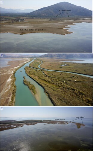
The rocky coasts are located at the level of the Mavron-Oros hill and the Lygia peninsula. Overall, these limestone massifs plunge directly into the sea with the exception of three pocket-beaches on the Lygia peninsula, only one of which is made up of coarse sand, the others being made up of boulders and pebbles.
The historic mouth of the Kalamas, located between the hill of Mavron-Oros and the Lygia peninsula, follows the same dynamics: the old front of the delta is made up of broad sandy spits (, C) which are being reshaped by the waves. The lagoons in the southern part of the delta are isolated from the Gulf of Igoumenitsa by a long sand spit. The latter connects several limestone hills with the Lygia peninsula, both of which were previously islands. The distal part of this coastal spit is now stabilized and connected to Igoumenitsa by a road.
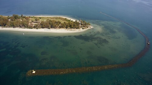
The analysis of aerial photos from 1945, 1969, 1981 and 2018 as well as the vectorization of the coastlines show that a large part of the delta is now subject to erosion processes. The retreat of the coast is not, however, uniform (). The construction of the dam and the canalization of the Kalamas have allowed a progradation of about 2 km (35 m/year) since 1962 (or 0.08 km²/year between 1969 and 1989 and 0.02 km²/year between 1989 and 2000) at the current mouth (CitationKarymbalis et al., Citation2006). These rates are very high when compared to other Greek deltas. Nevertheless, even this recent progradation is now subject to erosion. At the historic southern mouth, the retreat began from the time the dam was built, as the sediment supply was no longer sufficient to compensate for the action of waves and coastal drift. The frontal lobes of the delta are decreasing more and more and the sand bars are no longer supplied with sand. Some are now completely submerged and their existence can only be guessed from aerial photographs (main map). The salt marshes have gradually been inundated and their logging roads are now submerged in places. The long coastal spit to the south is held in place by submarine rock fillings, which limit the erosive action of the longshore drift ().
Figure 6. Coastal evolution of the Kalamas river delta since 1945 according to aerial photographs and remote sensing data.
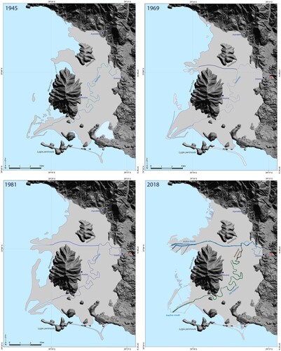
Figure 7. Submerged anti-erosion structure located at the distal part of a sandspit in front of Igoumenitsa (Referred to as Field Photography D on the main map for its location (copyright Geotag Aeroview 2016-2017)).
4 Discussion
The geomorphological mapping of a delta is a difficult task due to the variable nature of these low coastal areas after a storm or a flood. But it highlights the unique geomorphological characteristics of the Kalamas delta compared to the other deltas of the Ionian facade. The now abandoned southern mouth is typical of a river-dominated delta, but sheltered behind spits that reflect active wave-reworking. The western mouth, active today, demonstrates the characteristics of a wave-river dominated morphology. This double characteristic is unique in this area. The other large delta of the Ionian facade is that of the Acheron river: it presents a typical morphology of a wave dominated delta with very extensive concentric beach-ridges (CitationBesonen et al., Citation2003; Citation1997). The influence of the waves seems to be less important in the Corfu Strait: their height as well as the wind speeds are relatively low there, in comparison to other coasts of Greece (CitationSoukissian, Citation2005; CitationTsimplis, Citation2005). The fact that the island of Corfu provides shelter, probably has a lot to do with it.
The projected rise in sea level towards the end of the century directly threatens lagoons and coastal lowlands (CitationDay et al., Citation2008; CitationKontogianni et al., Citation2012; CitationLekka et al., Citation2011).
The shift from a sediment-rich delta with a well-developed delta plain to a sediment-starved delta, has caused major morphological changes. Wave-reworking has been particularly active in the southern mouth. The gradual disappearance of sand spits will make them more vulnerable to action of the waves. Reworking of the active mouth has also commenced. This indicates that the bedload stored in the channel, following dam sequestration upstream, is now being exhausted. This could spell the progressive demise of the delta in the context of sea-level rise. One outcome of the progressive erosion of the active mouth would be a shift to an increasingly wave-dominated delta and a gradual regularization of the coastline (CitationAnthony, Citation2015; CitationIbáñez et al., Citation2014). In addition to the compaction of the deltaic sediments, large parts of the delta could be flooded (CitationKarymbalis et al., Citation2006; CitationPsimoulis et al., Citation2007). Another consequence will be the gradual salinization of the soils in the delta (CitationGkiougkis et al., Citation2015), which, in turn, may negatively affect agricultural production.
5 Conclusion
The geomorphological map of the Kalamas delta that we propose is the result of a field study as well as an analysis of old maps and aerial images. This map also contains the extension of the catchment of the river along with its lithology and some of its hydrological characteristics. In addition, a geological section offers insight on the inner structure of the delta. The field study put emphasis on the significant mobility of the landforms during the Holocene.
The reconstruction of the evolution of the coastline since 1945 was achieved through the study of aerial images and old maps. The channeling diversion and the dam construction in 1962 both induced major changes in the Kalamas delta morphology and altered its sediment regime and deposition. Between 1962 and the beginning of the 2000s, the active mouth prograded seaward at a mean rate of 30 m/year. The progradation front is made up of a succession of beach ridges and sandy spits whose south-west/north-east orientation depends on the longshore drift. Conversely, the southern part of the delta, which constitutes the historical mouth of the river, is gradually disappearing: the sediment input from the river no longer counterbalances the erosive action of the waves.
The global rise in sea level could, in addition to completely reshaping the coastlines, increase the risks of erosion and submersion and thus disrupt fragile ecosystems and negatively impact the local economy (agriculture and tourism).
Software
Esri ArcGis 10, QGIS 3.10.7, Global Mapper 17, Adobe Illustrator CC 2017.
TJOM_A_2046654_Suplementarymaterial
Download PDF (70.2 MB)Acknowledgements
The authors would like to thank the 32nd Thesprotia Ephorate of Antiquities, the IGME, Prof. G. Philippakis, G. Riginos, V. Lamprou, the Ecole française d’Athènes and the UMR CNRS 8591 LGP., Prof. G. Apostolopoulos, S. Disiou T. Beuzen, S. Brousse, A. Creuzieux, I. Kougkoulos, J.-B. Léger, A. Levivier, R. Perrier for their help in the field.
N. Bouchilloux, A. Anagnostopoulou & G. Gentle for contributing to the English version of the manuscript.
We also thank the three anonymous reviewers for their careful reading of our manuscript and their insightful comments and suggestions
Data Availability Statement:
Data available on request from the authors.
The data that support the findings of this study are available from the corresponding author, [AC], upon reasonable request.
Disclosure statement
No potential conflict of interest was reported by the author(s).
References
- Maps
- Institutions selling these data
- https://www.eagme.gr/
- https://www.gys.gr/
- Anthony, E. J. (2015). Wave influence in the construction, shaping and destruction of river deltas: A review. Marine Geology, 361, 53–78. https://doi.org/10.1016/j.margeo.2014.12.004
- Anthony, E. J., Marriner, N., & Morhange, C. (2014). Human influence and the changing geomorphology of Mediterranean deltas and coasts over the last 6000years: From progradation to destruction phase? Earth-Science Reviews, 139, 336–361. https://doi.org/10.1016/j.earscirev.2014.10.003
- Athanassoulis, C., Zaimis, S., Chatziapostolou, A., & Agalaniotou, S. (2017). Therapeutic Mud occurrences In Greece: Mineralogical And geochemical composition of The Sagiada Mud (Thesprotia prefecture). Bulletin of the Geological Society of Greece, 50(2), 616–624. https://doi.org/10.12681/bgsg.11766
- Aubouin, J. (1959). Contribution à l’étude géologique de la Grèce septentrionale: Les confins de l’Epire et de la thessalie. Annales Géologiques des Pays Helléniques, 10, 525. Athenes.
- Bailey, G., & Flemming, N. (2008). Archaeology of the continental shelf: Marine resources, submerged landscapes and underwater archaeology. Quaternary Science Reviews, 27(23-24), 2153–2165. https://doi.org/10.1016/j.quascirev.2008.08.012
- Besonen, M. R. (1997). The middle and late Holocene geology and landscape evolution of the lower Acheron river valley, Epirus, Greece [Master's thesis]. University of Minnesota. https://hdl.handle.net/11299/212466
- Besonen, M. R., Rapp, G., & Zhichun, J. (2003). The Lower Acheron River Valley: Ancient Accounts and the Changing Landscape. Hesperia Supplements, Vol. 32, Landscape Archaeology in Southern Epirus, Greece 1, pp. 199-263.
- Bousquet, B. (1976). La Grèce occidentale. Interprétation géomorphologique de l’Epire, de l’Acarnanie et des îles Ioniennes [Thèse]. Université Paris-Sorbonne. Atelier de reproduction des thèses de Lille 3. Honoré Champion, Paris. 585 p.
- Brückner, H., Vött, A., Schriever, A., & Handl, M. (2005). Holocene delta progradation in the eastern Mediterranean– case studies in their historical context. Méditerranée. Revue Géographique des Pays Méditerranéens / Journal of Mediterranean Geography, 104, 95–106.
- Chabrol, A., Apostolopoulos, G., Pavlopoulos, K., Fouache, E., & Le Cœur, C. (2012). The Holocene evolution of the Kalamas delta (northwestern Greece) derived from geophysical and sedimentological survey. Géomorphologie : Relief, Processus, Environnement, 18(1), 45–58. https://doi.org/10.4000/geomorphologie.9731
- Christophilopoulou, A. (2002). Enquête sur la topographie de la zone littorale nord de la thesprotie. In Cabanes P. & Lamboley J. L. (Eds.), L’illyrie méridionale et l’Épire dans l’Antiquité – IV, actes du IVe Colloque International de Grenoble (10–12 Octobre 2002) (pp. 191–196).
- Dakaris, S. Ι. (1972). Θϵσπρωτία, Athens, Αθηναϊκό Κέντρο Οικιστικής.
- Day, J. W., Christian, R. R., Boesch, D. M., Yáñez-Arancibia, A., Morris, J., Twilley, R. R., Naylor, L., Schaffner, L., & Stevenson, C. (2008). Consequences of climate change on the ecogeomorphology of coastal wetlands. Estuaries and Coasts, 31(3), 477–491. https://doi.org/10.1007/s12237-008-9047-6
- Fouache, E. (2006). 10 000 ans d’évolution des paysages en Adriatique et en Méditerranée orientale (Géomorphologie, Paléoenvironnements, Histoire). MOM Éditions (Vol. 45). Maison de l’Orient et de la Méditerranée Jean Pouilloux.
- Gaki-Papanastassiou, K., Cundy, A.-B., & Maroukian, H. (2011). Fluvial versus tectonic controls on the late Holocene geomorphic and sedimentary evolution of a small Mediterranean fan delta system. The Journal of Geology, 119(2), 221–234. https://doi.org/10.1086/658144
- Gaki-Papanastassiou, K., Maroukian, H., Pavlopoulos, K., & Zamani, A. (1997). The implications of the expected sea level rise on the low lying areas of continental Greece in the next century. Proceedings International Symposium on Engineering Geology and the Environment (pp. 121–126).
- Gens, R. (2010). Remote sensing of coastlines: Detection, extraction and monitoring. International Journal of Remote Sensing, 31(7), 1819–1836. https://doi.org/10.1080/01431160902926673
- Ghilardi, M., Kunesch, S., Styllas, M., & Fouache, E. (2008). Reconstruction of Mid-Holocene sedimentary environments in the central part of the Thessaloniki Plain (Greece), based on microfaunal identification, magnetic susceptibility and grain-size analyses. Geomorphology, 97(3-4), 617–630. https://doi.org/10.1016/j.geomorph.2007.09.007
- Gkiougkis, I., Kallioras, A., Pliakas, F., Pechtelidis, A., Diamantis, V., Diamantis, I., Ziogas, A., & Dafnis, I. (2015). Assessment of soil salinization at the eastern Nestos River Delta, N.E. Greece. CATENA, 128, 238–251. https://doi.org/10.1016/j.catena.2014.06.024
- Hammond, N. G. L. (1967). Epirus. The geography, the ancient remains, the history and the topography of Epirus and adjacent areas. Oxford.
- Ibáñez, C., Day, J. W., & Reyes, E. (2014). The response of deltas to sea-level rise: Natural mechanisms and management options to adapt to high-end scenarios. Ecological Engineering, 65, 122–130. https://doi.org/10.1016/j.ecoleng.2013.08.002
- IGME. (1967). Geological map of Greece, Filiates sheet (scale 1:50,000). Institute of Geology and Mineral Exploration of Greece.
- IGME. (1969a). Geological map of Greece, Parga sheet (scale 1:50,000). Institute of Geology and Mineral Exploration of Greece.
- IGME. (1969b). Geological map of Greece, Sagiada sheet (scale 1:50,000). Institute of Geology and Mineral Exploration of Greece.
- IGME. (1983). Geological map of Greece, (scale 1:500,000). Institute of Geology and Mineral Exploration of Greece.
- IGRS - IFP (Institut de Géologie et Recherches du Sous-Sol, Athènes - Institut Français du Pétrole. (1966). Schéma tectonique de l’Epire, 1/500,000. Etude Géologique de l'Epire (Grèce Nord-occidentale). Editions Technip, 306.
- James, L. A., Hodgson, M. E., Ghoshal, S., & Latiolais, M. M. (2012). Geomorphic change detection using historic maps and DEM differencing: The temporal dimension of geospatial analysis. Geomorphology, 137(1), 181–198. https://doi.org/10.1016/j.geomorph.2010.10.039
- Kanta-Kitsou, E. (2008). Gitana-Thesprotial. Archaeological guide. Ministry of culture, 32nd ephoria of prehistoric and classical antiquities of Thesprotia. 80p.
- Kanta-Kitsou, E. (2009). Δίκτυο αρχαιολογικών χώρων Θϵσπρωτίας. Ηγουμϵνίτσα: Εφορϵία Αρχαιοτήτων Θϵσπρωτίας. 65 p.
- Kapsimalis, V., Pavlakis, P., Poulos, S., Alexandri, S., Tziavos, C., Sioulas, A., Filippas, D., & Lykousis, V. (2005). Internal structure and evolution of the late Quaternary sequence in a shallow embayment: The amvrakikos gulf, NW Greece. Marine Geology, 222-223, 399–418. https://doi.org/10.1016/j.margeo.2005.06.008
- Karymbalis, E., & Gaki-Papanastasiou, K. (2008). Geomorphological study of the river Deltas of Pinios, Kalamas, Evinos and Mornos. Proceedings of the 4th Panhellenic Conference Management and improvement of coastal zones. Laboratory of Harbour Constructions. National Technical University of Athens (pp. 86–94). (in Greek).
- Karymbalis, E., Gaki-Papanastassiou, K., Tsanakas, K., & Ferentinou, M. (2016). Geomorphology of the Pinios River delta, Central Greece. Journal of Maps, 12(sup1), 12–21. https://doi.org/10.1080/17445647.2016.1153356
- Karymbalis, E., Karageorgiou, M.-M., Parcharidis, I., & Karageorgiou, D. (2006). Recent coastal changes and implications of the future sea-level rise at the Kalamas River Delta (Western Greece). In A. Turbielewicz (Ed.), Coastal dynamics, geomorphology and protection (pp. 197–204). Gdansk University.
- Kazakis, N., Chalikakis, K., Mazzilli, N., Ollivier, C., Manakos, A., & Voudouris, K. (2018). Management and research strategies of karst aquifers in Greece: Literature overview and exemplification based on hydrodynamic modelling and vulnerability assessment of a strategic karst aquifer. Science of The Total Environment, 643, 592–609. https://doi.org/10.1016/j.scitotenv.2018.06.184
- Kerkira, G. Sarande, 1896. Austrian Military Map, 1/200,000.
- Knight, J., Mitchell, W. A., & Rose, J. (2011). Chapter six - geomorphological field mapping. In M. J. Smith, P. Paron, & J. S. Griffiths (Eds.), Developments in earth surface processes (Vol. 15, pp. 151–187). Elsevier.
- Kontogianni, A., Tourkolias, C., Skourtos, M., & Papanikolaou, M. (2012). Linking Sea level rise damage and vulnerability assessment: The case of Greece. in S. Young, S. Steven (Eds) International Perspectives on Global Environmental Change. DOI: 10.5772/27807
- Korfu (Kerkira). (1914). Military Topographic Map, 1/200,000. Printed by k.u.k. Militärgeographisches Institut. 66.7(52.5 cm.
- Krina, A., Xystrakis, F., Karantininis, K., & Koutsias, N. (2020). Monitoring and projecting land use/land cover changes of eleven large deltaic areas in Greece from 1945 onwards. Remote Sensing, 12(8), 1241. DOI:10.3390/rs12081241
- Lambeck, K. (1996). Sea-level change and shoreline evolution in Aegean Greece since Upper Palaeolithic time. Antiquity, 70(269), 588–611. https://doi.org/10.1017/S0003598X00083733
- Lapie, P. (1826). Carte physique, historique et routière de la Grèce: dressée au 400,000e d'après les matériaux recueillis par Mr. le Lieut.-Général Comte Guilleminot. From The Library of General Nicholas Charles Oudinot. 61(41 inches).
- Lekka, E., Kagalou, I., Lazaridou-Dimitriadou, M., Albanis, T., Dakos, V., Lambropoulou, D., Mallinis, G., Emmanoloudis, D., Giannakopoulos, V., Maris, F., & Koutsias, N. (2011). Mapping and interpreting historical land cover/land use changes in a Natura 2000 site using earth observational data: The case of Nestos delta, Greece. Applied Geography, 31(1), 312–320. https://doi.org/10.1016/j.apgeog.2010.07.002
- Lekka E, Kagalou I, Lazaridou-Dimitriadou M, Albanis T, Dakos V, Lambropoulou D, Sakkas V (2004). Assessment of the water and habitat quality of a Mediterranean river (Kalamas, Epirus, Hellas), in accordance with the EU water framework directive. Acta Hydrochimica et Hydrobiologica, 32(3), 175−188. https://doi.org/10.1002/aheh.200300528
- Maroukian, H., Gaki-Papanastassiou, K., Pavlopoulos, K., & Zamani, A. (1995). Comparative geomorphological observations in the Kalamas delta in western Greece and the Sperkhios delta in eastern Greece. Rapp. Comm. Int. Mer. Medit., 34, 110 (Abstract).
- Maroukian, H., & Karymbalis, E. (2004). Geomorphic evolution of the fan delta of the Evinos river in western Greece and human impacts in the last 150 years. Zeitschrift für Geomorphologie, 48(2), 201–217. https://doi.org/10.1127/zfg/48/2004/201
- Mertzanis, A., Papadopoulou, K., Goudelis, G., Papadopoulos, A., & Efthimiou, G. (2013). Threats to the coastal environment and wetlands in river deltas of Epirus (Northwest Greece). Proceedings of the 4th International Conference on Environmental Management, Engineering, Planning and Economics (CEMEPE) and SECOTOX Conference (pp. 1037–1044).
- Mimikou, M. (1982). An investigation of suspended sediment rating curves in western and northern Greece. Hydrological Sciences Journal, 27(3), 369–383. https://doi.org/10.1080/02626668209491116
- Nikolaou, E. (2010). ΥΔΡΟΓΕΩΛΟΓΙΚΗ ΜΕΕΤΗ, ΥΔΑΤΙΚΟ ΔΙΑΜΕΡΙΣΜΑ ΗΠΕΙΡΟΥ. Ινστιτούτο Γϵωλογικών και Μϵταλλϵυτικών Ερϵυνών (IGME), Preveza. 285 p.
- Ntoanidis, L. (2015). Intercomparison of the lumped versus semi-distributed HEC-HMS hydrological model in the Kalamas River basin. Extended abstract.
- Ntokos, D. (2017). Neotectonic - Geomorphological study of Epirus, Northwestern Greece and compiling of Neotectonic map, by use of geographic information systems [Doctoral dissertation]. National Technical University of Athens, 404 (in Greek).
- Ntokos, D. (2017). Synthesis of literature and field work data leading to the compilation of a New geological Map—A review of geology of northwestern Greece. International Journal of Geosciences, 08(2), 205–236. https://doi.org/10.4236/ijg.2017.82009
- Ntokos, D. (2018). Neotectonic study of Northwestern Greece. Journal of Maps, 14(2), 178–188. https://doi.org/10.1080/17445647.2018.1445562
- Otvos, E. G. (2000). Beach ridges — definitions and significance. Geomorphology, 32(1-2), 83–108. https://doi.org/10.1016/S0169-555X(99)00075-6
- Papathanassiou, E., & Zenetos, A. (2005). State of the Hellenic marine environment. Athens: HCMR Publications, 360. https://epublishing.ekt.gr/el/8303
- Pavlopoulos, K., Evelpidou, N., & Vassilopoulos, A. (2009). Mapping Geomorphological Environments. Springers eds. 236p.
- Perissoratis, C., & Conispoliatis, N. (2003). The impacts of sea-level changes during latest Pleistocene and Holocene times on the morphology of the Ionian and Aegean seas (SE Alpine Europe). Marine Geology, 196(3-4), 145–156. https://doi.org/10.1016/S0025-3227(03)00047-1
- Perissoratis, C., & Conispoliatis, N. (2003). The impacts of sea-level changes during latest Pleistocene and Holocene times on the morphology of the Ionian and Aegean seas (SE Alpine Europe). Marine Geology, 196(3-4), 145–156. https://doi.org/10.1016/S0025-3227(03)00047-1
- Petropoulos, G. P., Kalivas, D. P., Griffiths, H. M., & Dimou, P. P. (2015). Remote sensing and GIS analysis for mapping spatio-temporal changes of erosion and deposition of two Mediterranean river deltas: The case of the axios and aliakmonas rivers, Greece. International Journal of Applied Earth Observation and Geoinformation, 35, 217–228. https://doi.org/10.1016/j.jag.2014.08.004
- Poulos, S. E., & Chronis, G. T. (1997). The importance of the river systems in the evolution of the Greek coastline. In F. briand and A. Maldonado, Transformations and evolution of the mediterranean coastline. CIESM Sciences Series n°3, Bulletin de l’institut Océanographique, Monaco, n° spécial, 18, 75–96.
- Poulos, S. E., Ghionis, G., & Maroukian, H. (2009). The consequences of a future eustatic sea-level rise on the deltaic coasts of Inner Thermaikos Gulf (Aegean Sea) and Kyparissiakos Gulf (Ionian Sea). Geomorphology, 107(1-2), 18–24. https://doi.org/10.1016/j.geomorph.2006.07.044
- Pouqueville, F. C. H. L. (1826). Voyage de la Grèce, volume 2.
- Psimoulis, P., Ghilardi, M., Fouache, E., & Stiros, S. (2007). Subsidence and evolution of the Thessaloniki Plain, Greece, based on historical levelling and GPS data. Engineering Geology, 90(1-2), 55–70. https://doi.org/10.1016/j.enggeo.2006.12.001
- Sagiadha. (1970). Hellenic Military Geographical Service, 1/50,000.
- Simboura, N., Maragou, P., Paximadis, G., Kapiris, K., Papadopoulos, V. P., Sakellariou, D., Pavlidou, A., Hatzianestis, I., Salomidi, M., Arvanitidis, C., & Panayotidis, P. (2019). Chapter 9 - Greece. In C. Sheppard (Ed.), World seas: An environmental evaluation (Second Edition, pp. 227–260). Academic Press.
- Smith, M., Paron, P., & Griffiths, J. (2011). Geomorphological mapping methods and applications. Elsevier Science. 610 p.
- Soukissian, T. (2005). The wave climate of the Aegean Sea: Wave winds. State of the Hellenic Marine environment. In E. Papathanassiou, & A. Zenetos (Eds.), HCMR Publ. 360 pp, p. 65–71.
- Tsimplis, M. (2005). The wave climate of the Aegean Sea: The tidal signal. State of the Hellenic Marine environment. In E. Papathanassiou, & A. Zenetos (Eds.), HCMR Publ. 360 pp, p. 71–74.
- Vandarakis, D., Liosis, N., & Pavlopoulos, K. (2013). The geomorphological mapping of Keros island (Cyclades, Greece). Ψηφιακή Βιβλιοθήκη Θϵόφραστος - Τμήμα Γϵωλογίας. Α.Π.Θ.
- Vandarakis, D., Liosis, N., Pavlopoulos, K., Fachard, S., & Knodell, A. (2013). Geomorphological mapping of the Mazi-Oinoe area, Northwest Attica, Greece. Ψηφιακή Βιβλιοθήκη Θϵόφραστος - Τμήμα Γϵωλογίας. Α.Π.Θ.
- Vassiliadis, S. (2008). Historical and Geographical atlas of the Greek-Albanian border. Publication of the 32nd Ephorate of Antiquities in Igoumenitsa, 132 p.
- Waters, J. (1994). The tectonic evolution of Epirus, northwest Greece [Doctoral dissertation]. University of Cambridge. 248 p.