
ABSTRACT
The Asinara Island Marine Protected Area (AMP) (Sardinia, Italy) represents one of the most uncontaminated areas of the Mediterranean Sea and, therefore, but misses of an accurate mapping of the biocenoses and associated lithologies present on the sea floor. The provided map has highlighted the presence of 21 biocenoses laying on rocky or sandy substrate if shallower or deeper respectively. The most recurring are: the Posidonia oceanica L (Delile) and the coralligenous. The good state of conservation the P. oceanica meadow characterizing the eastern part of the island, and the diffuse presence Coralligenous reefs on the western side, are indicative of the well conditions of the marine ecosystem of the Asinara Marine Protect area. Moreover, the Coralligenous reefs developed on beach rocks have allowed defining which was the paleogeography of the Asinara Island during the time interval comprised from 12.9 to 10.0 ka Before Present (BP).
1. Introduction
Marine mapping provides important information necessary to perform a correct environmental planning of sensitive areas. It allows identifying hot spots of biodiversity, changing in biotic cover, and defining the abiotic sea-floor characteristics of a precise ecosystem (CitationBianchi et al., Citation2012; CitationDe Muro et al., Citation2016, Citation2018; CitationDeiana et al., Citation2019; CitationIchter et al., Citation2015; CitationVassallo et al., Citation2018).
Marine Protected Areas need a continuous mapping of the biocenoses and seafloor physiography to define their conservation state and temporal changes that occurred as a consequence, for instance, of the ongoing climate changes (CitationDe Luca et al., Citation2018, Citation2020; CitationDeiana et al., Citation2019). Moreover, the new awareness for environmental accounting, to assess the value of natural capital in marine protected areas (CitationVassallo et al., Citation2017), has raised the need for continuously updated marine maps.
The National Park of the Asinara has recently made a new acquisition of geophysics data (Multi-Beam and Side Scan Sonar) of the Marine Protected Area (MPA). These have allowed high-resolution bathymetry of the MPA of the Asinara being the base for the creation of a benthic habitat map and a more comprehensive maritime spatial planning of this protected area (CitationRomeo et al., Citation2019). The aim of this paper is, to use the available geophysical and direct seafloor observation, to provide an accurate map of the seafloor surrounding the Asinara Island (Sardinia, Italy) highlighting the main biocenoses and associated lithologies.
2. Area of study
The Asinara island is located in the northwestern end of Sardinia Island ((A,B)) between Punta Colondri to the south (40°59′N), Punta dello Scorno to the north (41°07′N), Punta Salippi to the west (4°15′E) and Punta Sabina to the east (4°06′E) ((C)). It has an area of 51,230 km2 and a length of about 18 km. Its width varies from 286.6 m in the central part to 6.5 km in the northernmost part of the island. Its coastal perimeter is 110.5 km ((C)).
Figure 1. Sardinia Island. (A) Satellite view of the Mediterranean region where Sardinia occupies a central position. Dashed line indicates the Sardinia anticlockwise rotation occurred in the Neogene time. A read * is point at the Asinara Island (source of the picture is Google Earth); (B) Digital terrain model of Sardinia; in the map are reported the main cities. In the square, the Asinara Island studied area. Abbrevitions: BI = Balearic Islands; lp = Liguro-Provençal Basin; Ty = Tyrrhenian Sea. C) The Asinara Isla (nd). In the picture are indicated the limit and zones, with different degrees of environmental protection of the Marine Protected Area: (red line) no-entry no-take (Zones A); (yellow line) general reserve (Zone B), and (withe line) partial reserve (Zone C) (source of the picture is Ortophoto 2008-Regione Sardegna, RAS).
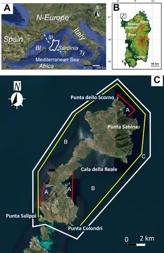
The Asinara Island in 1997 became National Park after having been a high-security prison since 1885. This has allowed the maintenance of peculiar Mediterranean flora and fauna and has prevented serious damage to the coastal marine assemblages making the island one of the most uncontaminated marine ecosystems of the Mediterranean Sea (CitationVilla et al., Citation2002). In 2002, the Marine Protected Area (MPA) of the park was established. This area surrounds the island with an extension of about 108 km2. The MPA area is subdivided into zones with different degrees of environmental protection: three no-entry no-take zones (Zones A); one for general reserve (Zone B), and one for partial reserve (Zone C) ((C)).
2.1. Seafloor physiography
The Asinara Island has remarkable physiographic differences between the western and the eastern coast. The western coast, facing the open sea, is characterized by high rocky coastlines (up to 200 m) with steep cliffs and a few narrow gravel pocket beaches. The coast deepens sharply seaward reaching – 100 m depth in less than 2 km. The seafloor is mostly characterized by rocks and sands on which diffuse Coralligenous reefs occur (CitationDe Falco et al., Citation2022). This part of the island during fall and winter is shaped by the dominant west and north-west (Mistral) coming winds ((C), Main map).
The eastern sector faces the Asinara Gulf and is characterized by a low relief coast where sandy pocket beaches alternate with headlands. The bathymetric gradients are very gentle and never exceed –50 m depth. The seafloor is mostly covered by Posidonia oceanica (L.) Delile (CitationDonda et al., 2008) ((C), Main map).
2.2. Geological setting
Sardinia is the second biggest island of the Mediterranean Sea ((A)) and represents a segment of the south-European plate that was separated from the European continent during the early Miocene (CitationCherchi & Montadert, Citation1982; CitationDoglioni et al., Citation1999) ((A)). The Asinara Island preserves part of the Hercynian Sardinian-Corsica basement, represented by medium and high-grade metamorphic complexes separated by a dextral shear zone, note as the Posada-Asinara Line (CitationCarosi et al., Citation2004; CitationCuccuru et al., Citation2018). The metamorphic rocks are intruded by late-Variscan granites belonging to the volcano-plutonic province of the Corsica-Sardinia Batholith. The Batholith formed during Carboniferous-Permian times, in response to crustal thinning related to the post-collisional exhumation of the Hercynian Chain (CitationCasini,Cuccuru,Maino,et al., 2015; CitationCasini,Cuccuru,Puccini, et al., 2015; CitationCuccuru et al., Citation2018; CitationPaquette et al., Citation2003). Non-metamorphic marine and aeolian rocks only crop out in the flat area close to Cala Reale ((C)) (CitationCarmignani et al., Citation2015). These are witnesses of the marine transgressive and regressive episodes that characterized the Sardinian depositional environment during Quaternary (CitationAndreucci et al., Citation2010; CitationCasini et al., Citation2020; CitationPascucci et al., Citation2014; Citation2018; CitationSechi et al., Citation2018, Citation2020). The typical morphologies related to these sea-level fluctuations are paleo-fluvial valleys known as rias (CitationDonda et al., Citation2008; CitationRomeo et al., Citation2019). Rias are forming canyons mostly occurring in front of westerly pocket beaches and are filled with sand derived from the erosion of the crystalline basement (CitationDonda et al., Citation2008; CitationRomeo et al., Citation2019) ((C)). Beach rocks have been identified along the western coast of Asinara Island at depths of –50 m (CitationRomeo et al., Citation2019).
2.3. Ecological setting
The Asinara Island, being a prison since the 1997, was inhabited for centuries. As a result, it is characterized by a high number of abandoned buildings in different states of decay and the presence of many feral ungulates (CitationMassida, Citation2008; CitationPungetti et al., Citation2016). Influenced by the grazing and rooting pressure, the landscape mostly consists of typical Macchia and Garrigue. The forested area in the northern part of the island only comprises about 0.2 km2. Freshwater bodies are rare – only four ponds are perennial, providing year-round water (CitationWinter et al., Citation2020).
The integrity of the island is more evident in the marine ecosystem mainly characterized by a high diversity of the floral-faunistic communities (CitationCasu et al., Citation2004; CitationCossu & De Luca, 2015; CitationPadiglia et al., Citation2018; CitationPais et al., Citation2004), by a considerable valuable landscape and by the high quality of water in chemical pollution and ecological terms (CitationFloris et al., Citation2020).
Well-structured associations and facies of the midlittoral and upper infralittoral stages, rich in elements of extreme naturalistic and biogeographical interest, occur (CitationCasu et al., Citation2004). The bioconcretions of Lithophyllium byssoides (Lamarck) Foslie and the mature stands of Patella ferruginea Gmelin bear witness to the excellent quality of the environment (CitationCasu et al., Citation2006; CitationCossu & De Luca, Citation2014).
The well-being of the infralittoral stage is enhanced by the wide Posidonia oceanica (L.) Delile meadow with an excellent state of conservation (CitationCossu & De Luca, 2015).
The photophilic algae biocenosis, another important formation of hard substrates, shows good ecological conditions, especially on the western side, with great richness and extreme complexity due to the strong physical gradients present on the island (CitationCasu et al., Citation2004).
The circalittoral stage probably shows the most interesting aspects. The association with large Fucophyceae on the bottom of the detrital coastal area, characterized by shells and calcareous algae of the ‘rhodolite’ or ‘praline’ type, has to be highlighted. This association is mainly located in the north and northwestern sector at depths between –50 and –80 m and is found near rocky shoals or at the level of the continental slope, where offshore waters have stable temperatures comprised between 13 and 15°C (CitationCossu et al., Citation2009).
3. Methods
The sea floor map of the MPA of the Asinara Island was made by the integrated use of Side Scan Sonar (SSS), ground truth points acquired with Remote Operating Veichles (ROVs) ((A)), and direct observation of the shallower part of the MPA. These data have been integrated with Multi Beam (MB) data () and aerial photo analysis ((C)). SSS and MB data were acquired by Istituto Nazionale di Oceanografia e di Geofisica Sperimentale (OGS) for the Asinara National Park during two campaigns 2015 and 2016 (CitationRomeo et al., Citation2019). The used SSS is a DF-1000/DCI Digital with a dual frequency of 100 and 500 KHz (EDGE TECH, Massachusetts, USA). The used MB is a Teledyne Reson SeaBat 7125, which operates with a dual-frequency of 200–400 KHz, and is composed of 512 beams in equidistance or equiangular mode. The survey was made with a slate range of 120 m and a line spacing of at least 20%. The SSS and MB were towed with a 15 m longboat (BT 1428 SIRIUS), equipped with a GPS RTK Geodetic System Trimble DSM 232 modular receiver DGPS.
Figure 2. (A) Side Scan Sonar (SSS) sea floor mosaic of the Asinara Island (modified after CitationRomeo et al., Citation2019). Dashed lines indicate the 21 ROV transects, red and black spots the extrapolated transects; (B) Detail of the SSS mosaic relative to the western side of the island. Note that lower backscatter (Lb) dominates the narrow areas in front of the gravelly pocket beaches, whereas the higher backscatter (Hb) dominates the deepest part of the shelf. Pr = pre-Coralligenous, Cr = Coralligenous; (C) Detail of the SSS mosaic of the Cala della Reale embayment. Note the quasi-circular clearing (Cl) interrupting the continuity of the Posidonia oceanica meadow (patchy backscatter = Pb); I = channels, s = spot of Biocenosis at Holothuria sp. Codium bursa Feoficee. (D) Detail of the SSS mosaic in front of P.ta Sabina. Pb = P.oceanica patchy backscatter, Lb = fine sand lower backscatter, Ab = alternate high and low backscatter relative to the dune field (D). The dune field is NNE-SSW oriented.
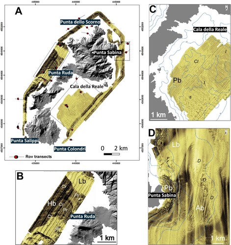
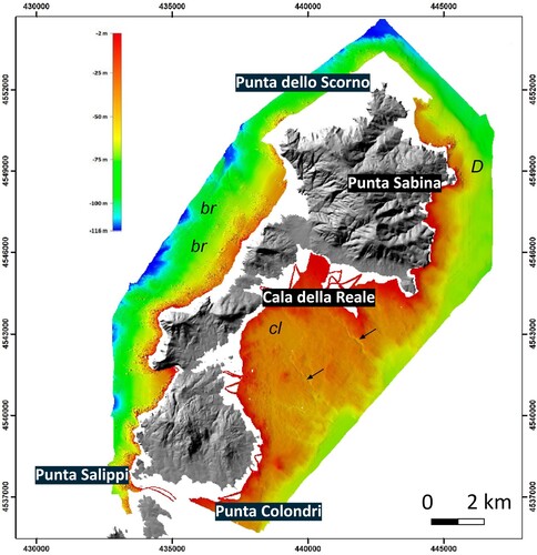
Figure 3. High Resolution swath bathymetric map (Multi Beam) of the Marine Protected Area of the Asinara Island. Arrows indicate the channels of the Cala della Reale emabyment; cl = quasi-circular, funnel shaped clearing, br = beachrocks, D = Dune field (Modified after CitationRomeo et al., Citation2019).
Two Remote Operating Vehicles (ROVs) ‘Velociraptor’ (Enne Elettronica, Savona, Italy) and Minirov Mod. DeepTrekker DTG3, were used to acquire videos and photos of the seafloor features. Both were equipped with a high-quality video camera with grand angular lens providing a field view of 80° and with two 50-W halogen spotlights, and with a Tritech MicronNav position System.
Twenty-one ROV transects, at least 1 km long, have been surveyed. From, each of them, nine transects of 200 m in length were subsequently extrapolated ((A)). For any of these, high-definition video and photographic material were processed with the aid of specific software: VideoLAN VLC for frame extraction and Seascape for image analysis. The latter is developed specifically for underwater digital photography of benthic community (CitationTeixidó et al., Citation2011).
The used aerial photos are Ortophoto 2008 (Regione Sardegna, RAS) and BaseMap Esri images (Digital Globe) with a resolution of 0.5 m and accuracy of 10.2 ((C)). Each data was a layer and GIS tools were used in the production of different maps.
Side Scan Sonar data were in part reprocessed using the software SeaView Mosaic (Mogasoftware). The SW provided a high-resolution seafloor acoustic mosaic interpreted using qualitative backscatter values based on different backscatter intensities. The backscatter signal is a function of the topography, in particularly of the seafloor slope, which influences the angle of incidence and the nature of the seafloor, and of the roughness of the material. This has allowed us to generate a map based on different acoustic facies. Facies where controlled with video ROV inspections. Inspections have proved that generally fine sediments exhibit lower backscatter, higher is typical of coarse sand and/or rocky substrate, medium/high patchy backscatter identifies the Posidonia oceanica meadows. These considerations have allowed us to distinguish biocenoses and abiotic features present on the seafloor.
The acoustic mosaic is presented using a bronze color scale, with higher backscatter intensity corresponding to darker color and lower backscatter intensity the lighters ().
Multi Beam data were mostly used to define the limits and continuity of the abiotic features. These has allowed us to make paleogeographic considerations of the Asinara Island during the Holocene.
The final map was edited at a scale of 1:25,000 interpreting to 0.250 m pixel resolution SSS mosaic integrated with ROV images. Aerial photo interpretation and direct observation of the infralittoral zones were used in the shallower areas. MB data were complimentary used with SSS to obtain a morphological description of the seafloor.
4. Results
The Marine Protected Area has been ideally subdivided according to its physiography in western and eastern parts ((C)). These are also characterized by a different geology, morphology, ecology and main biocenoses. Twenty-one different biocenoses have been mapped on the base of direct observation and photo interpretation the shallower part and their acoustic facies in the deeper (Main map). The main character of the biocenoses and associated lithology will be described in the follow.
4.1. The western part
4.1.1. Shallower part
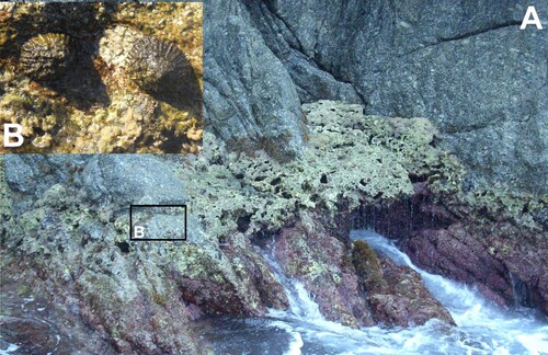
High-energy weaves characterize the morphology and geology and, consequently, the biocenoses of this area. Rocks are present all along the northwestern side of the island representing the seaward continuation of those present in outcrop. Algae colonizing this substrate are photophilic belonging to the Biocenosis of the upper infralittoral rock in sheltered waters The most common species are Cystoseira (Cystoseira amentacea var. stricta, C. brachycarpa var. balearica (Sauvageau) Giaccone e Cystoseira compressa (Esper) Gerloff & Nizamuddin), Lithophyllum byssoides (Lamarck) Foslie, Patella ferruginea (Gmelin). In shaded areas or in the semi-dark caves sciaphilous biocenosis dominates (). Posidonia oceanica on rocks has been mapped only in the central part of the area.
Figure 4. Biocenosis of the upper infralittoral rock in sheltered waters. (A) Lithophyllum byssoides (Lamarck) Foslie and (B) Patella ferruginea (Gmelin).
4.1.2. Deeper part
Two main SSS acoustic facies are the dominating feature of this part of the seafloor ((B)). Lower backscatter is dominant in front of embayments and narrow areas where gravelly pocket beaches occur, whereas the higher backscatter dominates the deepest part of the shelf. In the central part of the area, elongated and sub-rounded high and inomogeneous backscatter features have also been recognized.
4.1.3. Interpretation
The lower backscatter has been referred to the Biocenosis of the coastal detritic bottom. It represents the infilling of the canyons that could be followed up to −100 m depth ((B) and and Main map). This infill has been ROV surveyed and referred to fine sand derived from the erosion of the crystalline basement. It could reach the thickness of about 27 m in the most depressed part of the canyon (CitationDonda et al., Citation2008; CitationRomeo et al., Citation2019). No sedimentary structures have been recognized during surveys.
The higher backscatter has been referred to Biocenosis of coarse sand and fine gravel Influenced by bottom current ((B)). The recurrent specie is Phyllariopsis purpurascens (C. Agardh) normally anchored to the coarse sand. ROV imaged that sand and gravel are made of coarse clastic and bioclastic grains. Dunes and mega-ripples are the most common sedimentary structures. They are mostly oriented toward the SW (240°).
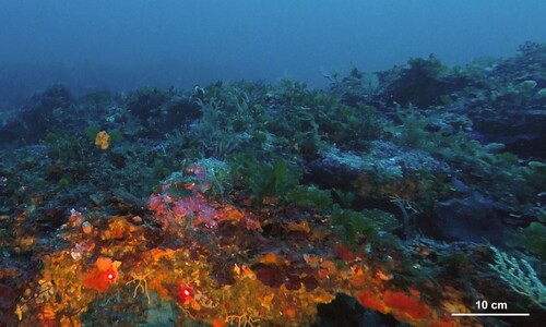
Elongated and sub-rounded acoustic features have been interpreted as Coralligenous and pre-Coralligenous biocenoses. They are quite abundant in this part of the MPA and found at depth between −50 and −90 m (Main map). They occur as isolated patch reefs or ribbon like structures directly lying on rocks, at the base of cliffs and on boulders dispersed in the sandy floor colonized by gorgonians. In the central western part, they form ridges (3 km long) at depth comprised between −50 and −60 m ((b) and , Main map). Coralligenous most common species are Lithophyllum sp., Mesophillum sp. Peyssonnelia rubra (Gmelin), Flabelia petiolata (Turra) Nizamuddin, Peyssonnelia squamaria (S.G. Gmelin) Decaisne, Osmundaria volubilis (L.) R.E. Norris, Axinella sp, Myriapora truncata (Pallas) and colonies of Eunicella cavolinii (Koch) and Eunicella singularis (Esper) ().
Figure 5. Coralligenous reefs. In the pictures are visible the following species: Lithophyllum sp., Mesophillum sp. Peyssonnelia rubra (Gmelin), Flabelia petiolata (Turra) Nizamuddin, Peyssonnelia squamaria (S. G. Gmelin) Decaisne, Osmundaria volubilis (L.) R.E. Norris and colonies of Eunicella cavolinii. The two red dots distance is 10 cm.
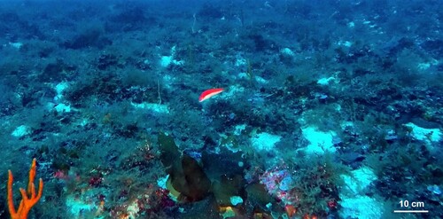
ROV surveys indicated the wide presence of the Laminaria rodriguezii Bornet. This deep-water brown alga is endemic of the Mediterranean Sea (CitationBoisset et al., Citation2016) and safeguarded (CitationBoudouresque et al., Citation1991). It is normally found fixed to big rocks () and constitutes an ideal habitat for numerous species of commercial importance (CitationGiaccone, Citation1967). This alga is typical of the Circalittoral Stage where there is homoeothermy in the water column and high nutrient content due to up-welling. This condition is also demonstrated by the presence of calcareous rhodoliths in the ripples concavity.
Figure 6. The Laminaria rodriguezii Bornet.
4.2. The eastern part
This part of the Asinara island is shallower, shaded to the dominant westerly coming winds and low energy weaves characterize most of the sea floor features. The wide embayment of Rada della Reale occupies the central part of the area ((C)). Rocky and sandy substrate dominate the coastal shallow water part; Biocenoses of the upper infralittoral rock in unsheltered water and of fine sand in shallower water are dominant.
Medium-low patchy backscatter is the main acoustic facies of the area. At depth of −20 m, a quasi-circular, funnel shaped feature interrupts the continuity of the facies in its central part ((C) and ). This feature deepens up to −30 m depth in the center and is connected to the outer part of the embayment through a relatively deep incision. A second incision is visible just few km toward the northeast ((C) and ). The incisions and circular feature are characterized by a dominant high backscatter punctuated by low backscatter spots ((C)).
In the northeastern part of the area, in front of P.ta Sabina, the dominant patchy backscattered, visible all around the headland, is bounded seaward by a relatively medium-high backscatter, surrounded by lower backscatter (in places very bright) passing southward to an alternate of high and low backscatter acoustic facies ((D)).
4.2.1. Interpretation
Medium-low patchy backscatter has been associated to the Posidonia oceanica meadow, representing the main biocenosis of this part of the MPA. The meadow occupies most of the embayment with the lower limit that could exceed −35 m depth. The matte mostly developed on sand, although P. oceanica on rock could be occasionally found. The matte is relatively compact with rare intramatte ((C)). Dead leaves of P. oceanica have been ROV imaged and mapped only in the northwestern tip of the embayment. Small meadows of Cymodocea nodosa Ucria (Ascherson) and Caulerpa prolifera (P. Forsskal) Lamouroux occur in the same part of the Rada as well.
The acoustic character of the incisions and circular feature, confirmed by direct ROV observation, is indicative of Biocenosis of the coastal detritic bottom, whereas the dispersed spots of the Biocenosis at Holothuria sp. Codium bursa Feoficee (high backscatter). Fine and bioclastic sand are the recurrent lithologies. The circular feature is interpreted as a clearance in the P. oceanica meadow, whereas incisions are interpreted as channels. A high resolution seismic profile cutting the first channel indicates it is 2 km long, 25 m wide and 10 m deep (CitationDonda et al., Citation2008). MB well images the channels and their termination at depth of −40 m ().
The lower backscatter characterizing the outer par of Pt. Sabina has been interpreted as Biocenosis of the mediolittoral fine sand in unsheltered water. The alternate of high and low backscatter is referred to the Biocenosis of coarse sand and fine gravel under the influence of bottom current. This backscatter is due to the alternation of fine and coarse sand. This alternation has allowed us to identify a giant 2 km long dune field surrounding P.ta Sabina headland ((D)). Dunes are roughly parabolic and oriented toward the west. They tend to become linear toward the south (N-S oriented) and remain parabolic toward the north (NNE-SSW oriented). They gradually disappear losing their character just out from the headland. The field formed as consequence of submarine currents associated to the NE coming wind (Grecale) dominating this part of the island.
5. Discussion
The Sea Floor Map of the Asinara Marine Protected Area has highlighted by the well state of the Posidonia oceanica meadow in the eastern side and the diffuse presence of Coralligenous reefs in the western.
The meadow does not present evidences of severe damages. Signs of illegal trawl fishing have only been detected inside Cala della Reale embayment. Of interest is, instead, the clearing interrupting the meadow almost in the central part of the embayment. The funnel shape and morphology of this feature resemble a paleo coastal lagoon formed when Relative Sea Level was between −38 and −35 m below the present; that is between 11,200 and 9700 years Before Present (y BP) (CitationBenjamin et al., Citation2017; CitationMoscon et al., Citation2015). Cala della Reale during this time (early Holocene) was most probably a coastal plain characterized by a lagoon fed by (ephemeral) rivers and connected to the open sea by relatively deep channels forming small deltas sourcing a suite of beach systems. The paleo shoreline was probably coincided with the present morphological step imaged by the Multi Beam at about −40 m (, main map). This could also explain the abundance of sand found in this part of the island.
Coralligenous and pre-Coralligenous outcrops dominate the western part of the MPA. These temperate biogenic reefs are among the most important benthic ecosystems of the Mediterranean Sea and their conservation is a major challenge for the maintenance and management of coastal marine systems (CitationGoodwin, Citation2011; CitationMumby & Steneck, Citation2008). These reefs, because constituted by calcareous organisms, are sensitive to both anthropogenic pressures and climate changes, often acting simultaneously, and therefore especially threatened at global scale (CitationBellwood et al., Citation2004; CitationHoegh-Guldberg et al., Citation2007; CitationPezzolesi et al., Citation2017). Their widespread presence and relative abundance are indicative of good water quality and, in a wider sense, of good environmental quality (CitationPiazzi et al., Citation2018). Coralligenous reefs, due to their ecological services for fisheries and balance of CO2, are habitats of interest of the European Community (CitationBallesteros, Citation2006; CitationE.C., Citation1992, p. 1170 Code: reefs; CitationMartin & Gattuso, Citation2009; CitationMartin et al., Citation2014).
Of particular interest are the elongated ridges encrusted by Coralligenous found at depth of −50 and −60 m respectively ((B) and , main map). The ridge shape is similar to those described for beach rocks in other parts of Sardinia (CitationDe Falco et al., Citation2015; Citation2022; CitationDe Muro & Orrù, 1998; CitationDeiana et al., Citation2021). These beaches formed during still stands of the post Late Glacial Maximum sea level rise. In particular, considering the depth, beaches of the western Asinara offshore may have formed during the Younger Dryas between 12,900 and 11,700 years BP (CitationRasmussen et al., 2011); that is, between Water Melting Pulse (WMP) 1A (14.6–13.5 ka years BP) and WMP-1B (11.6–11.0 ka years BP) (CitationLiu & Milliman, Citation2004; CitationZecchin et al., Citation2015). During this relative cold period it is documented a significantly reduced rate of sea level rise (CitationBard et al., Citation2010) that may have allowed the development of beach ridges.
6. Conclusions
The mapping of marine habitat plays a key role in the management and conservation of natural systems and provides the spatial framework for ecosystem-based management (CitationDeiana et al., Citation2019). It has been estimated that only 5–10% of the seafloor is mapped at a comparable resolution to similar studies on land (CitationWright & Heyman, Citation2008). Furthermore, marine ecosystems are poorly described compared to their terrestrial counterparts (CitationDeiana et al., Citation2019). This knowledge is crucial for National Parks with associated Marine Protected Areas that need this information to better define strategies of management.
The sea floor map of the MPA of the Asinara Island has underlined once more that inside the park the Posidonia oceanica meadow is in a very good state, although the presence of sings of fish trawling. Moreover, the presence of a vast clearing inside the meadow has allowed us to hypothesize which was the palaeoenviroment of the island during the early Holocene (11,000–10,000 years BP).
The high-resolution mapping of the western rocky side of the island has allowed recognizing several Coralligenous reefs. Some of these reefs are encrusting a hard substrate constituted by beachrock ridges formed during post LGM sea level rise still stands occurred during the Younger Dryas (12,900–11,700 years BP). This evidence could be used in future studies to recognize both Coralligenous and beachrocks outcrops.
Software
Side Scan Sonar and Multi Beam data where processed by CitationRomeo et al. (Citation2019). Some Side Scan Sonar data where re-processed using SeaView 1.5.58 (Moga Software srl). Spatial analyses were performed and processed using ArcGIS Desktop version 10.7 (ESRI). ROV images were extracted using VideoLAN VLC and interpreted using Seascape. They are both open source free software. The first is available by VideoLAN Organization, the latter is available by the Free Software Foundation's GNU General Public License (GPLv3) in source code form.
TJOM_A_2052765_supplementary material
Download PDF (31.2 MB)TJOM_A_2052765_Supplementary Map
Download PDF (31.6 MB)Acknowledgements
The authors are indebted with Giovanni Cossu (Sealeaves) for the logistic support offered during sea campaigns. We thanks the Editor Mike J Smith and Associate Editor Tommaso Piacentini. We are grateful to the reviewers Cecilia Furlan, Francesco Mascioli and Daniele Casalbore for the provided comments that allowed us to improve the manuscript.
Data availability statement (DAS)
All the data used to realize the Sea Floor Map of the Asinara Island are property of the National Park of the Asinara Island. They could be requested directly to the park writing at [email protected], or visiting the website http://www.parcoasinara.org/
Disclosure statement
No potential conflict of interest was reported by the author(s).
Additional information
Funding
Related Research Data
References
- Andreucci, S., Clemmensen, L. B., Murray, A. S., & Pascucci, V. (2010). Middle to late Pleistocene coastal deposits of Alghero, northwest Sardinia (Italy): Chronology and evolution. Quaternary International, 222(1–2), 3–16. https://doi.org/10.1016/j.quaint.2009.07.025
- Ballesteros, E. (2006). Mediterranean Coralligenous assemblages: a synthesis of present knowledge. Oceanography Marine Biology. Annual Review, 44, 123–195. https://doi.org/10.1201/9781420006391
- Bard, E., Hamelin, B., & Delanghe-Sabatier, D. (2010). Deglacial meltwater pulse 1B and younger Dryas sea levels revisited with boreholes at Tahiti. Science, 327, 1235–1237.
- Bellwood, D. R., Hughes, T. P., Folke, C., & Nystrom, M. (2004). Confronting the coral reef crisis. Nature, 429(6994), 827–833. https://doi.org/10.1038/nature02691
- Benjamin, J., Rovere, A., Fontana, A., Furlani, S., Vacchi, M., Inglis, R. H., Galili, E., Antonioli, F., Sivan, D., Miko, S., Mourtzas, N., Felja, I., Meredith-Williams, M., Goodman-Tchernov, B., Kolaiti, E., Anzidei, M., & Gehrels, R. (2017). Late Quaternary sea-level changes and early human societies in the central and eastern Mediterranean Basin: An interdisciplinary review. Quaternary International, 449, 29–57. https://doi.org/10.1016/j.quaint.2017.06.025
- Bianchi, C. N., Morri, C., Chiantore, M., Montefalcone, M., Parravicini, V., & Rovere, A. (2012). Mediterranean Sea biodiversity between the legacy from the past and a future of change. In N. Stambler (Ed.), In life in the Mediterranean sea: A look at habitat changes (pp. 1–60). Nova Science Publishers. ISBN 978-161209644-5.
- Boisset, F., Ferrer-Gallego, P. P., Furnari, G., Cormaci, M., & Dennetiere, B. (2016). Typification of the Mediterranean endemic deep-water macroalga Laminaria rodriguezii Bornet (Laminariaceae, Phaeophyceae). Cryptogamie. Algologie, 37(2), 121–132. https://doi.org/10.7872/crya/v37.iss2.2016.121
- Boudouresque, C. F., Avon, M., & Gravez, V. (1991). Les especes marines à proteger en méditerranée (p. 447). GIS Posidonie.
- Carmignani, L., Oggiano, G., Funedda, A., Conti, P., & Pasci, S. (2015). The geological map of Sardinia (Italy) at 1:250,000 scale. Journal of Maps, 12(5), 826–835. https://doi.org/10.1080/17445647.2015.1084544
- Carosi, R., Di Pisa, A., Iacopini, D., Montomoli, C., & Oggiano, G. (2004). The structural evolution of the Asinara Island (NW Sardinia, Italy). Geodinamica Acta, 17(5), 309–329. https://doi.org/10.3166/ga.17.309-329
- Casini, L., Andreucci, S., Sechi, D., Huang, C.-Y., Shen, C.-C., & Pascucci, V. (2020). Luminescence dating of late Pleistocene faults as evidence of uplift and active tectonics in Sardinia. W MediterraneanTerra Nova, 32(Issue 4), 261–271. https://doi.org/10.1111/ter.12458
- Casini, L., Cuccuru, S., Maino, M., Oggiano, G., Puccini, A., & Rossi, P. (2015). Structural map of Variscan northern Sardinia (Italy). Journal of Maps, 11(1), 75–84. https://doi.org/10.1080/17445647.2014.936914
- Casini, L., Cuccuru, S., Puccini, A., Oggiano, G., & Rossi, P. (2015). Evolution of the Corsica–Sardinia Batholith and late-orogenic shearing of the Variscides. Tectonophysics, 646, 65–78. https://doi.org/10.1016/j.tecto.2015.01.017
- Casu, D., Ceccherelli, G., & Castelli, A. (2004). Spatial distribution of small benthic invertebrates in rocky upper infralittoral at the Asinara Island (NW Mediterranean): A pilot study. Vie et Milieu, 54, 239–245. https://doi.org/10.1007/s10750-005-1123-3
- Casu, D., Lai, T., Cossu, P., & Curini-Galletti, M. (2006). Inter-simple sequence repeat markers reveal strong genetic differentiation among populations of the endangered mollusk Patella ferruginea (Gastropoda: Patellidae) from two Sardinian marine protected areas. Marine Biology, 149(5), 1163–1174. https://doi.org/10.1007/s00227-006-0255-y
- Cherchi, A., & Montadert, L. (1982). Oligo-Miocene rift of Sardinia and the early history of the western Mediterranean basin. Nature, 298(5876), 736–739. https://doi.org/10.1038/298736a0
- Cossu, A., Chessa, L., Gazale, V., & Ragazzola, F. (2009). On The Circalittoral benthic communities In The Asinara Marine Park (2009). Biologia Marina Mediterranea, 16, 256–257. ISSN 1123-4245.
- Cossu, A., & De Luca, M. (2014). Distribuzione di Patella ferruginea Gmelin, 1791 nelle “no entry-zone” e nelle zone di fruizione parziale dell’AMP dell’Isola dell’Asinara. Biologia Marina Mediterranea, 21, 154–158. ISSN 1123-4245.
- Cossu, A., & De Luca, M. (2015). Monitoraggio habitat e specie marine costiere nel SIC-ZPS Isola dell’Asinara Biologia Marina Mediterranea. 22, 36–37.
- Cuccuru, S., Casini, L., Oggiano, G., & Simula, E. N. (2018). Structure of the Castellaccio Pluton (Asinara Island, Italy). Journal of Maps, 14(2), 293–302. https://doi.org/10.1080/17445647.2018.1463297
- De Falco, G., Antonioli, F., Fontolan, G., Lo Presti, V., Simeone, S., & Tonielli, R. (2015). Early cementation and accommodation space dictate the evolution of an overstepping barrier system during the Holocene. Marine Geology, 369, 52–66. https://doi.org/10.1016/j.margeo.2015.08.002
- De Falco, G., Conforti, A., Brambilla, W., Budillon, F., Ceccherelli, G., De Luca, M., Di Martino, G., Guala, I., Innangi, S., Pascucci, V., Piazzi, L., Pireddu, L., Santonastaso, A., Tonielli, R., & Simeone, S. (2022). Coralligenous banks along the western and northern continental shelf of Sardinia Island (Mediterranean Sea). Journal of Maps. https://doi.org/10.1080/17445647.2021.2020179. Published online: 19 Jan 2022.
- Deiana, G., Holon, F., Meleddu, A., Navone, A., Orrù, P. E., & Paliaga, E. M. (2019). Geomorphology of the continental shelf of Tavolara Island (Marine Protected Area ‘Tavolara-Punta Coda Cavallo’ – Sardinia NE). Journal of Maps, 15(2), 19–27. https://doi.org/10.1080/17445647.2018.1533895
- Deiana, G., Lecca, L., Melis, R. T., Soldati, M., Demurtas, V., & Orrù, P. E. (2021). Submarine geomorphology of the southwestern Sardinian continental shelf (Mediterranean Sea): Insights into the last glacial maximum sea-level changes and related environments. Water, 13(2), 155. https://doi.org/10.3390/w13020155
- De Luca, M., Chaiallah, A., Andreucci, S., Cossu, G., Santonastaso, A., Sechi, D., Stelletti, M., & Pascucci, V. (2020). Seafloor map of the Alghero Bay (Sardinia, Italy). Journal of Maps, 16(2), 669–679. https://doi.org/10.1080/17445647.2020.1805808
- De Luca, M., Pascucci, V., Gazale, V., Ruiu, A., Massetti, L., & Cossu, A. (2018). Marine benthic forms of the marine protected area Capo Caccia-Isola Piana (Sardinia, Italy). Journal of Maps, 14(2), 421–427. https://doi.org/10.1080/17445647.2018.148624
- De Muro, S., Ibba, A., & Kalb, C. (2016). Morpho-sedimentology of a Mediterranean microtidal embayed wave dominated beach system and related inner shelf with Posidonia oceanica meadows: The SE Sardinian coast. Journal of Maps, 12(3), 558–572. https://doi.org/10.1080/17445647.2015.1051599
- De Muro, S., & Orrù, P. E. (1998). Il contributo delle beachrock nello studio della risalita del mare olocenico. Le beachrock post-glaciali della Sardegna nord orientale. Italian Journal of Quaternary Sciences, 11, 1–21.
- De Muro, S., Porta, M., Pusceddu, N., Frongia, P., Passarella, M., Ruju, A., & Ibba, A. (2018). Geomorphological processes of a Mediterranean urbanized beach (Sardinia, Gulf of Cagliari). Journal of Maps, 14(2), 114–122. https://doi.org/10.1080/17445647.2018.1438931
- Doglioni, C., Gueguen, E., Harabaglia, P., & Mongelli, F. (1999). On the origin of W-directed subduction zones and applications to the western Mediterranean. In B. Durand, L. Jolivet, F. Horvath, & M. Séranne (Eds.), The Mediterranean basins: Tertiary extension within the Alpine orogen (pp. 541–561). Geological Society Special Publication. 156
- Donda, F., Gordini, E., Rebesco, M., Pascucci, V., Fontolan, G., Lazzari, P., & Mosetti, R. (2008). Shallow water sea-floor morphologies around Asinara Island (NW Sardinia. Italy). Continental Shelf Research, 28(18), 2550–2564. https://doi.org/10.1016/j.csr.2008.07.003
- E.C. (1992). Council Directive 92/43/EEC (habitat Directive) of 21 May 1992 on the conservation of natural habitats and of wild fauna and flora. As amended by the Accession Act of Austria, Finland and Sweden. Official Journal of the European Commission, 1(1.1), 135.
- Floris, M., Gazale, V., Isola, F., Leccis, F., Pinna, S., & Pira, C. (2020). The contribution of ecosystem services in developing effective and sustainable management practices in Marine Protected Areas. The Case Study of “Isola dell’Asinara. Sustainability, 12, 1108. https://doi.org/10.3390/su12031108
- Giaccone, G. (1967). Popolamenti a Laminaria rodriguezii Bornet sul Banco Apollo dell’isola di Ustica (Mar Tirreno). Nova Thalassia, 3, 1–9.
- Goodwin, E. J. (2011). International environmental law and the conservation of Coral reefs. (p. 296). Taylor and Francis Group. ISBN 9780415859585.
- Hoegh-Guldberg, O., Mumby, P. J., Hooten, A. J., Steneck, R. S., Greenfield, P., Gomez, E., Harvell, C. D., Sale, P. F., Edwards, A., Caldeira, K., Knowlton, N., Eakin, C. M., Iglesias-Prieto, R., Muthiga, N., Bradbury, R. H., Dubi, A., & Hatziolos, M. E. (2007). Coral reefs under rapid climate change and ocean acidification. Science, 318(5857), 1737. https://doi.org/10.1126/science.1152509
- Ichter, J., Evans, D., & Richard, D. (2015). Cartographie des habitats terrestres en Europe: Une vue d’en-semble. (p. 150). Muséum national d’Histoire naturelle. Rapport technique n°1/2015
- Liu, J. P., & Milliman, J. D. (2004). Reconsidering melt-water pulses 1A and 1B: Global impacts of rapid sea-level rise. Journal of Ocean University of China, 3(2), 183–190. https://doi.org/10.1007/s11802-004-0033-8
- Martin, C. S., Giannoulaki, M., De Leo, F., Scardi, M., Salomidi, M., Knittweis, L., Pace, M. L., Garofalo, G., Gristina, M., Ballesteros, E., Bavestrello, G., Belluscio, A., Cebrian, E., Gerakaris, V., Pergent, G., Pergent-Martini, C., Schembri, P. J., Terribile, K., Rizzo, L., … Fraschetti, S. (2014). Coralligenous and maerl habitats: Predictive modelling to identify their spatial distributions across the Mediterranean Sea. Scientific Report, 4(1), 5073. https://doi.org/10.1038/srep05073
- Martin, S., & Gattuso, J. P. (2009). Response of Mediterranean coralline algae to ocean acidification and elevated temperature. Global Change Biology, 15(8), 2089–2100. https://doi.org/10.1111/j.1365-2486.2009.01874.x
- Massida, F. (2008). The prison, lighthouse and sanitary station. In C. Forteleoni & V. Gazale (Eds.), Asinara, National park – protected marine area (p. 67–82, 252). Carlo Delfino editore.
- Moscon, G., Correggiari, A., Stefani, C., Fontana, A., & Remia, A. (2015). Very-high resolution analysis of a transgressive deposit in the northern Adriatic Sea (Italy). Alpine and Mediterranean Quaternary, 28, 121–129.
- Mumby, P. J., & Steneck, R. S. (2008). Coral reef management and conservation in light of rapidly evolving ecological paradigms. Trends Ecol. Evol, 23(10), 555–563. https://doi.org/10.1016/j.tree.2008.06.011
- Padiglia, A., Cadeddu, B., Ledda, F. D., Bertolino, M., Costa, G., Pronzato, R., & Manconi, R. (2018). Biodiversity assessment in western Mediterranean Marine Protected Areas (MPAs): Porifera of Posidonia oceanica meadows (Asinara Island MPA) and marine caves (Capo Caccia–Isola Piana MPA) of Sardinia. The European Zoological Journal, 85(1), 409–422. https://doi.org/10.1080/24750263.2018.1525440
- Pais, A., Azzurro, E., & Chessa, L. A. (2004). Distribution patterns of coastal fish assemblages associated with different rocky substrates in Asinara Island National Park (Sardinia, Italy). Italian Journal of Zoology, 71(4), 309–316. https://doi.org/10.1080/11250000409356588
- Paquette, J.-L., Ménot, R.-P., Pin, C., & Orsini, J.-B. (2003). Episodic and short-lived granitic pulses in a post-collisional setting: Evidence from precise U-Pb zircon dating through a crustal cross-section in Corsica. Chemical Geology, 198(1-2), 1–20. https://doi.org/10.1016/S0009-2541(02)00401-1
- Pascucci, V., De Falco, G., Del Vais, C., Melis, R. T., Sanna, I., & Andreucci, S. (2018). Climate changes and human impact on the Mistras coastal barrier system (W Sardinia, Italy). Marine Geology, 395, 271–284. https://doi.org/10.1016/j.margeo.2017.11.002
- Pascucci, V., Sechi, D., & Andreucci, S. (2014). Middle Pleistocene to Holocene coastal evolution of NW Sardinia (Mediterranean Sea, Italy). Quaternary International, 328–329. https://doi.org/10.1016/j.quaint.2014.02.018, 3–20
- Pezzolesi, L., Falace, A., Kaleb, S., Hernandez-Kantun, J. J., Cerrano, C., & Rindi, F. (2017). Genetic and morphological variation in an ecosystem engineer, Lithophyllum byssoides (Corallinales, Rhodophyta). Journal of Phycology, 53(1), 146–160. https://doi.org/10.1111/jpy.12488
- Piazzi, L., Gennaro, P., Montefalcone, M., Bianchi, C. N., Cecchi, E., Morri, C., & Serena, F. (2018). STAR: An integrated and standardized procedure to evaluate the ecological status of coralligenous reefs. Aquatic Conservation Marine and Freshwater Ecosystems, 29(2), 189–201. https://doi.org/10.1002/aqc.2983
- Pungetti, G., Congiatu, P., & Dettori, S. (2016). Cultural traces and landscape changes on Asinara, Italy. In G. Pungetti (Ed.), Island landscapes an expression of European culture (pp. 77–80). Elsevier B.V.. https://doi.org/10.4324/9781315590110
- Rasmussen, T. L., Thomsen, E., Nielsen, T., & Wastegård, S. (2011). Atlantic surface water inflow to the Nordic seas during the Pleistocene–Holocene transition (mid–late Younger Dryas and Pre-Boreal periods, 12 450–10 000 a BP). Journal of Quaternary Science, 26(7), 723–733. https://doi.org/10.1002/jqs.1496
- Romeo, R., Baradello, L., Blanos, R., Congiatu, P. P., Cotterle, D., Ciriaco, S., Donda, F., Deponte, M., Gazale, V., Gordini, E., Lodolo, E., Paganini, P., Pavan, A., Pietrapertosa, C., Sterzai, P., Vargiu, G., Zanello, A., Ramella, R., & Nieto Yabar, D. G. (2019). Shallow geophysics of the Asinara Island Marine Reserve area (NW Sardinia, Italy). Journal of Maps, 15(2), 759–772. https://doi.org/10.1080/17445647.2019.1669498
- Sechi, D., Andreucci, S., & Pascucci, V. (2018). Intertidal upper pleistocene algal build-ups (Trottoir) of NW Sardinia (Italy): A tool for past sea level reconstruction. Journal of Mediterranean Earth Sciences, 10, 167–171. https://doi.org/10.3304/JMES.2018.009
- Sechi, D., Stevens, T., Andreucci, S., & Pascucci, V. (2020). Age and significance of late Pleistocene Lithophyllum byssoides intertidal algal ridge, NW Sardinia, Italy. Sedimentary Geology, 400. https://doi.org/10.1016/j.sedgeo.2020.105618
- Teixidó, N., Albajes-Eizagirre, A., Bolbo, D., Le Hir, E., Demestre, M., Garrabou, J., Guigues, L., Gili, J. M., Piera, J., Prelot, T., & Soria-Frisch, A. (2011). Hierarchical segmentation based software for cover classification analyses of seabed images (Seascape). Marine Ecology Progress Series, 431, 45–53. https://doi.org/10.3354/meps09127
- Vassallo, P., Bianchi, C. N., Paoli, C., Holon, F., Navone, A., Bavestrello, G., Cattaneo Vietti, R., & Morri, C. (2018). A predictive approach to benthic marine habitat mapping: Efficacy and management implications. Marine Pollution Bulletin, 131, 218–232. https://doi.org/10.1016/j.marpolbul.2018.04.016
- Vassallo, P., Paoli, C., Buonocore, E., Franzese, P. P., Russo, G. F., & Povero, P. (2017). Assessing the value of natural capital in Marine Protected Areas: A biophysical and trophodynamic environmental accounting model. Ecological Modelling, 355(c), 12–17. https://doi.org/10.1016/j.ecolmodel.2017.03.013
- Villa, F., Tunesi, L., & Agardy, T. (2002). Zoning Marine Protected Areas through spatial multiple-criteria analysis: The case of the Asinara Island National Marine reserve of Italy. Conservation Biology, 16(2), 515–526. https://doi.org/10.1046/j.1523-1739.2002.00425.x
- Winter, R., Mantilla-Contreras, J., & Schmidt, S. (2020). Usage of buildings in the life cycle of two endangered Rhinolophus species in the Mediterranean region: Implications for roost protection. European Journal of Wildlife Research, 66(3), 38. https://doi.org/10.1007/s10344-020-01374-1
- Wright, D., & Heyman, W. (2008). Introduction to the special issue: Marine and coastal GIS for geomorphology, habitat mapping, and marine reserves. Marine Geodesy, 31(4), 223–230. https://doi.org/10.1080/01490410802466306
- Zecchin, M., Ceramicola, S., Lodolo, E., Casalbore, D., & Chiocci, F. L. (2015). Episodic, rapid sea-level rises on the central Mediterranean shelves afterthe last glacial maximum: A review. Marine Geology, 369, 212–223. https://doi.org/10.1016/j.margeo.2015.09.0020025-3227