
ABSTRACT
African paleoanthropological studies typically focus on regions of the continent such as Eastern, Southern and Northern Africa, which hold the highest density of Pleistocene archaeological sites. Nevertheless, lesser known areas such as West Africa also feature a high number of sites. Here, we present a high-resolution map synthesising all well contextualised Pleistocene archaeological sites present in Sub-Saharan West Africa. A detailed elevation and ecoregional map was developed and correlated with palaeoanthropological sites. This map is supplemented with 1,000- and 2000-year interval climate reconstructions over the last 120,000 years for three subregions of high archaeological interest. The presented archaeological sites were compiled by reviewing published literature, and selected based on: (1) documented archaeological stratification or >10 characteristic artefacts, (2) published coordinates, and (3) published chronometric ages or relative dating. The data presented here elucidates the current state of knowledge of Pleistocene West Africa, highlighting the regional potential for human evolutionary studies.
1. Introduction
African paleoanthropological studies have typically focused on regions of the continent such as Eastern, Southern and Northern Africa, which hold the highest concentration and density of Pleistocene archaeological sites. This notwithstanding, it is becoming clear that less well-researched regions, such as West Africa, also feature a high number of sites (e.g. CitationAllsworth-Jones, Citation2019; CitationDouze et al., 2021; CitationHuysecom et al., Citation2014; CitationNiang et al., Citation2018; CitationPetit, Citation2005; CitationScerri et al., Citation2021).
Here, we present a series of high-resolution maps synthesising Pleistocene archaeological sites reported in Sub-Saharan West Africa (Supplementary File 1). A detailed elevation map of the region developed from 1 km-resolution digital elevation models (DEMs; CitationJarvis et al., Citation2008) was categorised based on elevation and correlated with topographic bioregion to show geolocated and culturally attributed hominin sites. This map is supplemented with 1,000- and 2,000-year interval climate reconstructions over the last 120 thousand years (ka) for three individually mapped subregions with a high concentration of archaeological sites. In addition, modern ecoregions are considered together with the modern ecological locations of Pleistocene archaeological sites. The locations of archaeological sites were compiled by reviewing published literature. Partial, poorly understood, or questionable archaeological sites were excluded. The selection of archaeological sites included in the map was based on the following requirements: (1) a documented stratified archaeological origin, or not less than 10 characteristic artefacts, (2) published coordinates, and (3) published chronometric ages or relative dating (i.e. by cultural attribution such as lithic assemblage type, culture or tradition). Too often Sub-Saharan West Africa is considered a marginal region in African palaeoanthropology, however this map illustrates the high concentration and density of archaeological sites in the region. As paleoenvironmental studies are sporadic, or even absent, in most areas of West Africa, the local climate reconstructions provided will contribute towards achieving a better understanding of human-environment interactions and past human activities in Pleistocene Sub-Saharan West Africa.
2. Data and methods
The construction of the map required the collation of a wide variety of data sources. These include previously published archaeological datasets, published ecological biome distribution ranges and newly developed paleoclimatic datasets for areas of interest. These sources were used and developed with the objective of offering a wide ranging archaeo-ecological framework for Pleistocene West Africa.
The base dataset (see legend in Main Map, and Supplementary File 1), upon which this study is based, was constructed by reviewing previously published literature, including published articles, books and reports. A list of Pleistocene sites in West Africa was collated, recording the following variables for each site: (1) site name, (2) country, (3) type (open air, fluvial terrace, or rock shelter), (4) cultural attribution, (5) known or unknown stratigraphical origin, (6) number of recovered artefacts (<, = , or > than 10), (7) dating method used, (8) coordinates, and (9) original reference. By using the following variables, sites were selected for inclusion in this study, while partial, poorly understood, or questionable archaeological sites were excluded. The selection of archaeological sites included in the Main Map was based on the following requirements: (1) a documented stratified archaeological origin, or not less than 10 characteristic artefacts, (2) published coordinates, and (3) published chronometric ages or relative dating (i.e. by cultural attribution such as lithic assemblage type, culture or tradition). Cultural attribution, or the classification of each site within Stone Age periods (Early, Middle, Later, or a combination of them), was designated based on either the original attribution given by the authors of the referenced studies, or based on the observable published material culture. In most cases, the sites included in this study were published with an already attributed cultural designation. In the rare cases where this did not happen, the authors of this study classified the sites to a cultural attribution. In both cases, cultural attribution was designated based on the models of lithic technology (CitationClark, Citation1969) and lithic groups for each Stone Age period (CitationBarham & Mitchell, Citation2008). They are: (1) Early Stone Age (ESA; Mode 1 and 2), characterised by unifacial pebble tools and bifacially worked tools from large flakes and cores, e.g. handaxes and cleavers; (2) Middle Stone Age (MSA; Mode 3 and 4), characterised by prepared core technology, including the Levallois method, and typical MSA tools e.g. side and end scrapers, notched pieces denticulates; and (3) Later Stone Age (LSA; Mode 5), characterised by microlithic technology, including geometric microliths and segments. In the cases where sites displayed mixed or varied technological groups all divided into separate contexts, the site was attributed a range of Stone Age periods (e.g. Ounjougou contains different layers with materials ranging from the ESA to the LSA, therefore it was designated as ESA-LSA). Finally, regarding sites within the Falémé Valley, and building on the work of colleagues (e.g. Douze et al., 2021), we acknowledge the fact that while not all clear ESA/MSA/LSA assemblages are chronometrically dated, other chronometrically dated assemblages have an unclear cultural designation. Further study is yet needed to determine the local cultural character of such assemblages. We therefore note that all the sites within the Faleme Valley were culturally attributed solely on the published materials used for the database recording (full list of sites and references visible in Supplementary File 1).
The resulting dataset, collated and exported in a .csv file format, was imported on QGIS and was superimposed over an elevation map of the region developed from 1 km-resolution digital elevation models (DEMs, CitationJarvis et al., Citation2008). The elevation values from the original DEM dataset were categorised and colourised topographically and then further categorised into observable topographic bioregions, which are the following: coastal, flooded lowland, lowland, highland, sub-montane, and montane. Rivers and lakes were also included to offer modern distribution and location of major water sources (CitationCGIAR, Citation2014; CitationRCMRD, Citation2015). The adopted elevation- and topography-based approach led to the evaluation of site location and type in direct comparison with modern ecoregional zones (lower left corner, Main Map; CitationOlson et al., Citation2001) and modern political boundaries (CitationOCHA ROWCA, Citation2021). The included archaeological sites were further sub-sampled and divided into categories based on their cultural attribution. Three of the six total categories represent archaeological sites that only show one single cultural attribution (i.e. a dated chronometric range for the site that fits within a single cultural attribution range, or the retrieval of artefacts that are categorised only within one single cultural attribution), and they are Early Stone Age (ESA), Middle Stone Age (MSA), and Later Stone Age (LSA). The other three categories include archaeological sites that have dated stratigraphies, by either chronometric or typological dating, and include more than one single attribution. These categories are: Early Stone Age to Middle Stone Age, Middle Stone Age to Later Stone Age, and Early Stone Age to Later Stone Age.
From the evaluation of the Main Map and the geolocated archaeological sites, three subregions were selected for further analysis following their high concentration of archaeological sites. These subregions are: 1. Falémé Valley, Senegal, 2. Jos Plateau, Nigeria, and 3. Atakora Region, Benin. These subregions have been expanded and mapped individually (Main Map, left side). Furthermore, each of the three subregions are supplemented with 1,000-year interval climate model reconstructions over the last 21,000 years and 2000-year interval climate reconstructions over the last 22,000 to 120,000 years (lower right side). The paleoclimate models include plots of four climate variables, which include: annual mean temperature (BIO1), annual precipitation (BIO12), leaf area index (LAI), and net primary productivity (NPP). BIO1 and BIO12 model average annual mean temperature and precipitation in each subregion. Leaf area index represents the green leaf area per unit ground surface in broadleaf canopies, essentially offering a view of the density of forest canopies in each subregion, therefore modelling the presence of forest canopy coverages through time. Finally, net primary productivity was selected as it represents the amount of carbon dioxide metabolised by the vegetation in each subregion, therefore showing the density of faunal and floral biomass changes through time. The paleoclimate models are based on the combined HadAM3H and Hadley CM3 climate simulations published in CitationBeyer et al. (Citation2020) to model changes in climate for the selected subregions. We used the decimal coordinates of each of the subregion vertices to extract climate variable values at 0.5° resolution from the CitationBeyer et al. (Citation2020) dataset in 1000-year intervals (up to 21 ka) and 2000-year intervals (22-120 ka) (see Supplementary Data 2 for full script). All climate variable values were then scaled together (SCVV).
Data recording of the literature sources was carried out using Office Excel. For the Main Map (upper left corner) The exported data in .csv format was then imported on QGIS, where the DEM raster collation, averaging and visualisation was carried out. The same process was carried out for the ecoregional map (Main Map, lower left corner). The subregional maps (Main Map, centre left side) were extrapolated from the Main topographical map by using the crop function on QGIS. The paleoclimate data were processed and plotted using R. All the single maps and figures were exported from QGIS and R in a multi-layer .pdf format. The files were then imported on Adobe Illustrator 2021 where the Main Map was created adding final details, which included: 1. the assembling of all the single visualisations, 2. relabelling of visualised data, 3. standardisation of fonts, strokes and symbols, and 4. the addition of legends, labels, titles and logos.
3. Map description
The Main Map (upper left corner), exhibits all the archaeological sites of Pleistocene West Africa we were able to document, and shows a variety of trends and similarities, offering insights on the distribution, cultural characteristics and environmental footprints of past human activity in the region. The frequency of culturally attributed sites presents a skewing towards the presence of Middle Stone Age (MSA) sites (N = 52), representing the majority of recorded sites. Later Stone Age (LSA) sites (N = 9) are the second most frequent cultural sites in the region, and Early Stone Age (ESA) sites (N = 4) are the most sporadic with only four sites throughout West Africa. Firstly, the low frequency of ESA sites can be explained by the higher difficulty of identification and study, compared to its younger counterparts. This is probably a result of the deeper stratigraphy of ESA sites caused by a high sedimentation rate at tropical latitudes, including thick silt deposits caused by regular flooding in the river basins, and high possibilities of contamination from natural or anthropogenic processes at the oldest sites. The higher number of MSA sites, compared to LSA sites, may be explained either by: (1) a higher concentration of MSA human habitation of the region, or, most likely, (2) a research bias towards geographic, topographic and archaeological areas with a high occurrence of MSA sites.
The modern topographic distribution of the sites can offer clues towards the past human habitability of West Africa. Although topographic differences are to be expected between modern and Pleistocene landscapes, we consider major topographic features (coastal areas, major fluvial and lacustrine bodies, and montane environments) to have maintained their characters over the timeframe of the modelled biomes. Considering this, no distinct topographic preferences are observable, with the sites recorded in every context, spanning from coastal to montane habitats. Nevertheless, it is important to note that all the archaeological sites are situated within very close proximity to major water sources, and easily explained by the fundamental necessity of this prime resource for human survival and the habitability of a given location (CitationScerri et al., Citation2014). In particular, as visible in the Main Map, areas with a very high density of archaeological sites are all situated close to major fresh water sources, whether they be (1) coastal areas, such as the Guinean Coast in modern day Ivory Coast and Ghana, (2) river and floodplain areas, such as the Falémé Valley, or (3) high elevation areas with many fluvial terraces and stream systems such as the Atakora Region and Jos Plateau. The selection of the previously mentioned sub-regions was specifically based on these high archaeologically-dense areas, and have been complemented with their corresponding modern ecoregional boundaries (CitationOlson et al., Citation2001).
The first presented subregion (bottom left of Main Map), the Falémé Valley, is an area which follows the Falémé River. This is a region that has been of high archaeological interest for several decades (CitationChevrier et al., Citation2016; CitationDescamps, Citation1979; CitationHuysecom et al., Citation2014; CitationLebrun et al., Citation2016; CitationNiang et al., Citation2018; CitationNiang & Ndiaye, Citation2016; CitationRasse et al., Citation2004; CitationScerri et al., Citation2016; CitationScerri et al., Citation2021), displaying the presence of a multitude of sites spanning from the ESA (e.g. Djita), to the LSA (e.g. Fatandi V, Toumboura I). Most sites are situated within fluvial terraces, therefore representing past human activity taking place within riparian areas. Our paleoclimatic reconstruction for the region during the past 120 ka also shows that for most of its observed chronology it has undergone very little changes in temperature and humidity, mostly changing during the various stadial and interstadial stages. Also, the canopy coverage (LAI) and the environmental biomass (NPP) has been extremely stable for at least the last 100 ka. This paleoclimatic reconstruction possibly explains the suitability for human habitation in the region, and in turn the very high density of sites within it. This also shows how stable and suitable the Falémé Valley was for humans during the Pleistocene, a conclusion reinforced by previous studies (CitationScerri et al., Citation2016; CitationScerri et al., Citation2021). These results are consistent with other studies suggesting that West Africa has been relatively stable and broadly more humid than eastern Africa for the last 100 thousand years (CitationKaboth-Bahr et al., Citation2021).
The Jos Plateau, similarly to the Falémé Valley, is a region with a high density of archaeological sites. Nevertheless, the sites within this subregion are both culturally and environmentally different, as it contains solely MSA sites (CitationAllsworth-Jones, Citation2019), and it is among the highest topographic subregions of the whole of West Africa. Climatically, a wider range of climatic shifts occurred in this region during the last 120 ka, with major changes in temperature and humidity occurring in concurrence with stadial and interstadial stages These changes were especially evident during Marine Isotope Stages (MIS) 5 (and its relative substages) and MIS 1, and less so during MIS 4 to MIS 2. These climatic variabilities fit well with the observed hominin presence within the region, as MSA sites documented in the Jos Plateau were inhabited during the less climatically variable period between MIS 4 and 2.
Finally, the last subregion, Atakora, was also selected for its high density of archaeological sites. In this region a variety of sites, from the ESA to the LSA, are visible (CitationCerasoni et al., Citation2020a, Citation2020b; CitationDavies, Citation1967; CitationN’Dah, Citation2009; CitationPetit, Citation2005), suggesting continuous human habitation throughout the Pleistocene. Topographically, it is represented by a mixed geography, with both low altitude riparian valleys and high elevation areas resulting from the Atakora mountain chain. The Atakora Region is the subregion that underwent the most climatic variability, with extreme changes in every modelled variable during the last 120 ka. These climatic shifts occurred synchronously to stadial and interstadial stages and substages, seemingly having no direct effect on human habitability and distribution throughout the region. This is possibly attributable to all of the sites in the Atakora Region being situated within or near rivers and fluvial environments, with humans showing no preference for any topographic feature other than water during specific cultural periods.
4. Discussion
The combination of bibliographical, geospatial, paleoenvironmental and paleoclimatic data clearly shows an expected strong correlation between Pleistocene human activities and their environments. The various data collection and analyses performed here allow us to better consider Pleistocene archaeology and paleoenvironment in West Africa, displaying the arrangement and distribution of sites from decades of archaeological research.
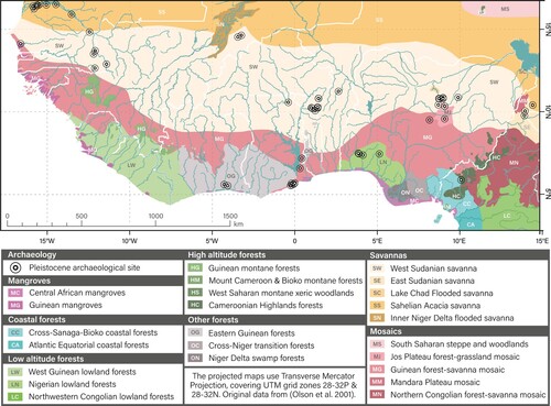
Ecologically, an equally wide distribution can be noticed with archaeological sites being widely presented in every modern biome, ranging from savanna dominated biomes of the Northern Sahelian regions to sub-coastal and montane rainforests of Nigeria and Cameroon (). The majority of sites are located within the Central and Northern regions which are today composed of Sahelian and Sudanian savannas, with much fewer sites in the lower latitudes of the region within tropical forested and mangrove environments. This difference, however, is not given by a portrayal of past human distribution in the region, but rather a bias towards preservation of archaeological sites which undergo more detrimental effects from the higher concentration of rainfall, humidity, temperature and increased soil depositional rates compared to non-tropical environments. Furthermore, our hypothesised climatic reconstructions for the three selected subregions shows a very complex environmental picture. Our observations, based on the modern biome distribution and modelled paleoenvironmental reconstructions, are a first tentative view of the Pleistocene environment history of West Africa. Given this, it should be noted that without detailed chronological frameworks for each of the considered sites we cannot assess direct human-environmental relationships at specific points in time. Therefore, although the modern ecological contexts of the displayed sites are a good starting point, in-depth chronological, climatic and environmental analyses will have to be carried out to better understand Pleistocene human-environment interaction in West Africa.
Figure 1. Modern ecoregional biomes of Sub-Saharan West Africa and location of Pleistocene archaeological sites. Original ecoregional data from CitationOlson et al. (Citation2001).
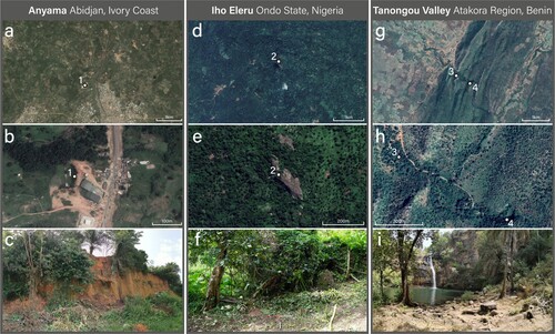
Although further fieldwork will be necessary to discover new West African Pleistocene sites, it is important to consider the reasons why there is a current imbalance between regions with a high concentration of sites and regions with little to no identified sites. Major bias inherent to past fieldwork projects exist, where systematic surveys were carried out mostly in a select handful of West African subregions. Regions such as Falémé Valley, Atakora (, g-i), and Jos Plateau contain a much higher concentration of identified archaeological sites not because of their higher Pleistocene human presence, but rather a modern archaeological bias caused by their environmental, sedimentary and political contexts. These areas are found within politically and environmentally stable areas, where Pleistocene deposits are easily accessible and visible. In contrast to these areas, other subregions such as Abidjan precinct (Ivory Coast) and Ondo State (Nigeria) contain a very low density of sites. As visible in (a-f), these subregions are characterised by very dense vegetation and increased sedimentation rates. Within them, the sites of Anyama and Iho Eleru are unique occurrences, where their Pleistocene deposits were identified as a consequence of mining, such as in the case of Anyama, and the preservation and protection of Pleistocene materials within a rock shelter, such as in the case of Iho Eleru.
Figure 2. Satellite imagery of Anyama (1; a-b), Iho Eleru (2; d-e), Paloli (3; g-h) and Tanongou Valley (4; g-i) in Tanongou Valley. Below them are site photographs showing the mining activity which revealed Anyama (c), the dense forested environment which surrounds Iho Eleru (f), and the open forested environment of Tanongou Cave (i).
It is therefore clear from our study and the map presented here, besides displaying the most reliable and accurately studied archaeological sites in West Africa, that a great extent of West Africa has yet not been effectively studied. Ideally systematic surveys will have to be carried out in the lesser known regions of West Africa to fill in the gaps, such as the central Sahelian plateaus between Guinea and Burkina Faso, and the Guinean coastal regions which are not in proximity of major metropolitan centres. However, the visibility of Pleistocene deposits will be a major issue for the identification of new site`s in regions where one or more of the following variables occur:
High depositional rates caused by increased humidity, rainfall, erosion and/or biomass exchange - causing Pleistocene deposits to be located below any visible surface or level.
Decreased erosional activity – causing any buried Pleistocene deposit to not be unveiled and found.
Lack of infrastructure and modern human presence – causing difficult access to any potential site containing Pleistocene deposits.
Inaccessibility caused by current political tensions and warfare – causing the impossibility to visit any potential site containing Pleistocene deposits.
The information presented in the Main Map, together with the observations that we can take from it, lead us to reasonably assume that future archaeological endeavours should concentrate on studying areas of West Africa which are currently underrepresented, while keeping in mind the issues stated above. Moreover, this map can be used as a reference for further archaeological studies not only in West Africa, but also the rest of the African continent, serving as an example and demonstration of the great density of archaeological sites, and the importance that West Africa had within the wider continental archaeological record.
Software
Bibliographical research and recording of the archaeological sites (visible in Supplementary File 1) was carried out on Office Excel. The exported .csv database, DEMs, ecoregional rasters, and other elements used in the map were created and modified on QGIS. For the subregion maps (Main Map, centre left side) QGIS was used to extrapolate and crop the final products from the Main topographical map. The paleoclimate model was performed using R version 3.6.2 and RStudio version 1.2.5033. All the single maps and figures were exported from QGIS and R in a multi-layer .pdf format. The files were then important on Adobe Illustrator 2021 where the Main Map was created adding final details, which included: 1. the assembling of all the single visualisations, 2. relabelling of visualised data, 3. standardisation of fonts, strokes and symbols, and 4. the addition of legends, labels, titles and logos.
Data
The database of archaeological sites (S1) and script of the paleoclimate model (S2) can be found as Supplementary Material or can be found in the following repository – https://doi.org/10.6084/m9.figshare.16895959.v3. The digital elevation models used to create the topographic map are from CitationJarvis et al. (Citation2008). Other shapefiles were used for the inclusion of water sources (CitationCGIAR, Citation2014; CitationRCMRD, Citation2015) and political boundaries (CitationOCHA ROWCA, Citation2021).
Author contributions
This study was designed by J.N.C., and conceived with E.M.L.S. and E.Y.H. The database was compiled by J.N.C. with support by E.B.A. and E.Y.H. The paleoclimatic reconstruction models were developed by R.M.B., M.K., and A.M., and applied to this study by E.Y.H. and A.M. The cartographic elements were developed by J.N.C. The initial draft was written by J.N.C., and all authors contributed to the revision of the paper.
TJOM_A_2052767_Supplementary material
Download PDF (55.3 MB)Disclosure statement
No potential conflict of interest was reported by the author(s).
Additional information
Funding
References
- Allsworth-Jones, P. (2019). The Middle Stone Age of Nigeria in its West African context. The Middle Stone Age of Nigeria in Its West African Context. https://doi.org/10.2307/j.ctvndv9c1
- Barham, L., & Mitchell, P. (2008). The First Africans: African Archaeology from the Earliest Toolmakers to most recent foragers (Cambridge world Archaeology). Cambridge University Press. https://doi.org/10.1017/CBO9780511817830
- Beyer, R. M., Krapp, M., & Manica, A. (2020). High-resolution terrestrial climate, bioclimate and vegetation for the last 120,000 years. Scientific Data, 7(1), 236. https://doi.org/10.1038/s41597-020-0552-1
- Cerasoni, J. N., N’Dah, D., Niang, K., N’Zi, C. D., Orijemie, E. A., & Scerri, E. M. L. (2020a). Newly discovered Middle Stone Age layers at Tannongou Valley, Atakora Region, Benin: Implications for Pleistocene hominin behaviour and ecology of West Africa. AARD.
- Cerasoni, J. N., N’Dah, D., Niang, K., N’Zi, C. D., Orijemie, E. A., & Scerri, E. M. L. (2020b). Pleistocene Archaeology and Tropical Paleoecology in West Africa. ESHE.
- CGIAR. (2014). Africa Rivers. http://landscapeportal.org/layers/geonode:africa_rivers_1#more
- Chevrier, B., Rasse, M., Lespez, L., Tribolo, C., Hajdas, I., Guardiola Fígols, M., … Huysecom, É. (2016). West African Palaeolithic history: New archaeological and chronostratigraphic data from the Falémé valley, eastern Senegal. Quaternary International, 408, 33–52. https://doi.org/10.1016/j.quaint.2015.11.060
- Clark, G. (1969). World prehistory: A new outline. Cambridge U.P.
- Davies, O. (1967). West Africa before the europeans: Archaeology & prehistory. In West Africa before the Europeans: Archaeology and prehistory (Vol. 19). https://doi.org/10.4324/9781315748283
- Descamps, C. (1979). Contribution à la préhistorie de l’ouest sénégalaid. Thése de doctorat de 3eme cycle d’archéologie préhistorique. Université de Paris - I.
- Douze, K., Lespez, L., Rasse, M., Tribolo, C., Garnier, A., Lebrun, B., Mercier, N., Ndiaye, M., Chevrier, B., & Huysecom, E. (2021). A West African Middle Stone Age site dated to the beginning of MIS 5: Archaeology, chronology, and paleoenvironment of the Ravin Blanc I (eastern Senegal). Journal of Human Evolution, 154, 102952. https://doi.org/10.1016/j.jhevol.2021.102952
- Huysecom, E., Loukou, Y. S. B., Mayor, A., Jeanbourquin, C., Chaix, L., Chevrier, B., … Timpoko Kiénon-Kaboré, H. (2014). Vallée de la Falémé (Sénégal oriental) et Parc national des îles Eotilé (Côte d’Ivoire): la 16ème année de recherche du programme «Peuplement humain et paléoenvironnement en Afrique». Jahresbericht SLSA, 2013, 113–176. http://archive-ouverte.unige.ch/unige:40221
- Jarvis, A., Reuter, H., Nelson, A., & Guevara, E. (2008). Hole-filled SRTM for the globe version 3, from the CGIAR-CSI SRTM 90m database. http://srtm.csi.cgiar.org
- Kaboth-Bahr, S., Gosling, W. D., Vogelsang, R., Bahr, A., Scerri, E. M., Asrat, A., … Trauth, M. H. (2021). Paleo-ENSO influence on African environments and early modern humans. Proceedings of the National Academy of Sciences, 118(23). https://doi.org/10.1073/pnas.2018277118
- Lebrun, B., Chantal, T., Benoît, C., Michel, R., Laurent, L., Alice, L., … Éric, H. (2016). Establishing a West African chrono-cultural framework: First luminescence dating of sedimentary formations from the Falémé Valley, Eastern Senegal. Journal of Archaeological Science: Reports, 7, 379–388. https://doi.org/10.1016/j.jasrep.2016.05.001
- N’Dah, D. (2009). Sites Archeologiques et Peuplement de la Region de L’Atakora (Nord-Ouest du Benin). Universite de Ouagadougou.
- Niang, K., Blinkhorn, J., & Ndiaye, M. (2018). The oldest Stone Age occupation of coastal West Africa and its implications for modern human dispersals: New insight from Tiémassas. Quaternary Science Reviews, 188, 167–173. https://doi.org/10.1016/j.quascirev.2018.03.022
- Niang, K., & Ndiaye, M. (2016). The Middle Palaeolithic of West Africa: Lithic techno-typological analyses of the site of Tiemassas, Senegal. Quaternary International, 408, 4–15. https://doi.org/10.1016/j.quaint.2015.11.086
- OCHA ROWCA. (2021). West and Central Africa - Administrative boundaries levels 0 - 2 / settlements. https://data.humdata.org/dataset/west-and-central-africa-administrative-boundaries-levels
- Olson, D., Dinerstein, E., Wikramanayake, E., Burgess, N., Powell, G., Underwood, E., … Kassem, K. (2001). Terrestrial ecoregions of the world: A New Map of life on earth. BioScience, 51(11), 933–938. https://doi.org/10.1641/0006-3568(2001)051[0933:TEOTWA]2.0.CO;2
- Petit, L. (2005). Archaeology and history in north-western Benin (vol. 1398). British Archaeological Reports Limited.
- Rasse, M., Soriano, S., Tribolo, C., Stokes, S., & Huysecom, E. (2004). La séquence pléistocène supérieur d’Ounjougou (Pays dogon, Mali, Afrique de l’Ouest) : évolution géomorphologique, enregistrements sédimentaires et changements culturels [The upper Pleistocene formations of Ounjougou : geomorphological evolution, sedimen. Quaternaire, 15(4), 329–341. https://doi.org/10.3406/quate.2004.1779
- RCMRD. (2015). Africa - Water Bodies. https://datacatalog.worldbank.org/dataset/africa-water-bodies-2015
- Scerri, E. M. L., Blinkhorn, J., Groucutt, H. S., & Niang, K. (2016). The Middle Stone Age archaeology of the Senegal River Valley. Quaternary International, 408, 16–32. https://doi.org/10.1016/j.quaint.2015.09.025
- Scerri, E. M. L., Drake, N. A., Jennings, R., & Groucutt, H. S. (2014). Earliest evidence for the structure of homo sapiens populations in Africa. Quaternary Science Reviews, 101, 207–216. https://doi.org/10.1016/j.quascirev.2014.07.019
- Scerri, E. M. L., Niang, K., Candy, I., Blinkhorn, J., Mills, W., Cerasoni, J. N., … Groucutt, H. S. (2021). Continuity of the Middle Stone Age into the holocene. Scientific Reports, 11(1), 70. https://doi.org/10.1038/s41598-020-79418-4