
ABSTRACT
The Piuro 1618 landslide is renowned as one of the most catastrophic historical events of the Central Alps. The landscape of the Bregaglia Valley has been successively modified to such an extent to make it difficult to ascertain the source of the landslide, the extent of its deposits and the setting of the ancient village. This study focuses on the identification of the source area of the landslide, its dynamics, the extent of its deposits and the estimation of the involved volumes. The geological map here proposed permitted to reconstruct the relationships between the pre-1618 setting, the 1618 restructuration of the landscape and the post-event changes that occurred owing to erosion by the trunk river, deposition of debris flow fans and slope dynamics. The paper shows how geological mapping may help to unravel landscape evolution of an Alpine valley even at the high-resolution required by historical and archaeological studies.
1. Introduction
In 1618 a large landslide wiped out the ancient town of Piuro, an important trade center of the Canton of Graubünden close to the head of the Bregaglia Valley, renowned for silk trade, soapstone manufactory and the artistic value of monuments and buildings. This relevant event caused about 1000 casualties and was documented by chronicles and paintings during the subsequent decades () (CitationScaramellini et al., 1988 among others).
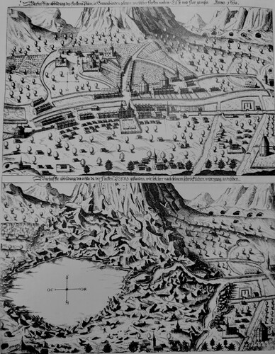
Figure 1. Piuro before and after the 1618 landslide by Balthasar Schwan, 1619 (after CitationScaramellini et al., 1995).
The exact geometry of the Piuro landslide deposits is difficult to recognize, due to the complex geomorphology of the valley bottom where the ancient town was built, and to the recent landscape evolution. Historical chronicles provided us with some clues on the signs and triggers of the event, on the width of the area affected by the landslide and on the thickness of its deposits. Unpublished studies (De Poli and Gherardi, 1988; ISMES, 1990–1992 – in CitationScaramellini et al., 1995) suggested a possible detachment zone of the landslide, the extent of its accumulation and its possible causes. However, the lack of a detailed geological map and of stratigraphic and morphological studies leave some questions open:
Among the several landslide bodies observed in the Piuro area, which one can be ascribed to the 1618 event?
Which is the precise location and geometry of the scar?
Is it possible to estimate the areal extent and volume of the 1618 landslide bodies, in order to fit the inferred scar geometry?
Which was the landslide dynamics?
The geological map here presented provides the stratigraphic and morpho-structural dataset to address these questions in the frame of the post-glacial geological evolution of the valley, and will contribute to define the archaeological landscape pre- and post-dating the 1618 Piuro disaster.
2. Methodology
Geological and geomorphological mapping at ‘1:10,000’ over approximately 15 km2 was conducted to integrate previous surveys of a larger area in the Bregaglia Valley (CitationTantardini, Citation2016). The new survey was addressed to reconstruct the facies and physical-stratigraphic relationships between the Quaternary sedimentary bodies exposed on the valley sides and floor of Piuro. Surface data were integrated by the interpretation of two boreholes (A.M.AL.PI.18 project, S1: 76 m b.g.s., S2: 25 m b.g.s.) and of an existing well log (B1: 146 m b.g.s., ISPRA). Archaeological excavations permitted to describe the stratigraphy and thickness of the Piuro 1618 landslide bodies at two sites (Mot del Castel and Belfort, Main Map). Compositional analyses on gravel to boulder clasts were conducted on samples from the boreholes in order to characterize the Quaternary lithosomes and for comparisons with the basement rocks on the valley slopes, to discriminate provenance from the southern and northern sides. Radiocarbon age determinations on some organic fragments sampled at the boreholes constrained the age of the most recent landslide deposits, confirming the eventual attribution to the 1618 event. The geomorphological and morpho-structural analysis (Main Map and Morpho-structural Scheme) were based on field observations and measurements, inspection of satellite and aerial images (Google Earth®; AGEA – 2012) and the analysis of a high-resolution DTM (0.5 m) of the Piuro area (CitationMarotta et al., 2021). Data were collected and managed in a GIS geo-database (Coordinate System WGS 1984 UTM Zone 32N). The geological map (Main Map) is represented on a vector topographic map (DataBaseTopograficoRegionale – Regione Lombardia). Integration of all data permitted (i) to delimitate the Piuro 1618 landslide bodies, that were separated from previous and subsequent landslide deposits, (ii) to locate them within the stratigraphic sequence of the post-glacial-historical lithosomes, (iii) to infer their thickness distribution, (iv) to relate them to a southern landslide scar and (v) to interpret the chronological evolution of the depositional events and the dynamics of the 1618 landslide.
3. Geological setting of the Italian Bregaglia Valley
Bregaglia Valley cross-cuts the stack of the Upper and Middle Penninic Nappes which include, from top to bottom, the Suretta and Tambò nappes and the Chiavenna and Gruf units (). This segment of the valley runs parallels the E-W Gruf Line. Tambò and Suretta nappes form the northern valley side while the mafic/ultramafic bodies of the Chiavenna Unit occur only in the southern valley side where they are pinched within the Tambò Nappe, in tectonic contact with the migmatites of the Gruf Complex (, Main Map, Geological setting, Section C–C′).
Figure 2. Tectonic scheme of the Lepontine-Rhaetian Central Alps with main tectonic lineaments (redrawn after CitationBigi et al. (1990); Swiss DTM taken from: https://data.opendataportal.at/dataset/dtm-switzerland – Author: Sonny). Blue square indicates the study area.
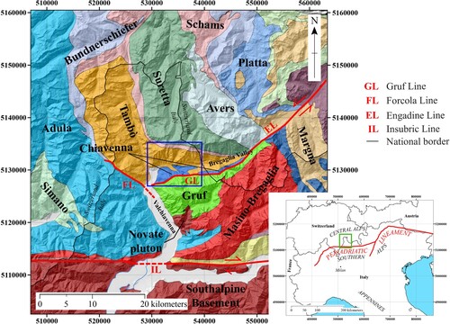
The Gruf Line (GL) has been interpreted as the prolongation of the sinistral strike-slip Engadine Line (CitationGalli et al., 2013; CitationSchmid & Froitzheim, Citation1993; Schmid et al., Citation1996; Schmutz, Citation1976; CitationTrümpy, Citation1977; CitationWenk, Citation1984), whose activity postdates cooling below 300°C of the Masino-Bregaglia, hence younger than 28 Ma (CitationCiancaleoni & Marquer, Citation2008). Recent seismicity and morpho-structural evidence along the Engadine-Gruf tectonic system (CitationTibaldi & Pasquarè, Citation2008) proves that these faults could be still active (CitationAlbini et al., 1988; CitationISMES, Citation1994). The alignment of Deep Seated Gravitational Slope Deformations (DSGDs) on the southern side (Main Map, Morpho-structural Scheme) suggests a correlation between slope instability and the Gruf Line (CitationTibaldi & Pasquarè, Citation2008). The Quaternary morphological evolution of the valley is relatable to the superposition of glacial, slope and alluvial dynamics. The LGM Engadina glacier filled the valley while minor lateral glaciers were confined at higher altitudes on the slopes (CitationTantardini, Citation2016). As a consequence, the trimline of the LGM glaciers in the Italian Bregaglia Valley varies from 2250 m a.s.l. (east) to 2170 m a.s.l. (west) (CitationTantardini, Citation2016). Many scarps and trenches affect sheepback rocks and glacial terraces on both sides of the valley, proving the intense post-glacial activity of DSGDs.
4. Geology of the Piuro 1618 landslide area
4.1. Bedrock: Penninic Nappes
The opposite slopes of the Bregaglia valley strongly differ in the study area (Main Map, Geological setting, Section C–C′).
The Tambò Nappe (TN) mostly forms the northern valley slope. It includes biotitic or two-micas gneiss, associated with garnet + staurolite bearing fine-grained gneiss, amphibole-bearing and leucocratic muscovite gneiss (TNa). The most widespread rocks are paragneiss composed by millimetric to centimetric bands of quartz and quartz + feldspar layers alternated to biotite ± white mica rich gneiss ((a)), sometimes garnet bearing. Massive porphyric meta-granites to banded, flaser and augen gneiss, locally with migmatitic facies, are locally known as ‘Truzzo metagranite’ (TNb). On the Northern side of Bregaglia Valley, augen to flaser orthogneiss are the most common TNb lithotypes ((b)). Greenish amphibolite lenses are composed by alternations of amphibole and plagioclase ± epidote millimetric layers ± quartz ± garnet (TNc) ((c)).
Figure 3. Most representative bedrock lithologies of the area: (a) TNa paragneiss; (b) TNb orthogneiss (‘Truzzo metagranite’); (c) TNc amphibolites; (d) CUa banded amphibolites; (e) CUa massive amphibolites; (f) CUb ultramafites; (g) CUb soapstone; (h) GCa enclaves-rich orthogneiss; (i) GCb migmatites.
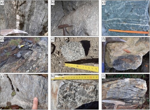
The Chiavenna Unit (CU) is divided into: CUa banded amphibolites, locally biotite or epidote bearing and rarely with clinopyroxenes, greenish or darker ((d)). Minor massive amphibolites composed by millimetric to centimetric horneblende + plagioclase are present ((e)); CUb ultramafites and ultramafic fels, that comprise serpentinites with olivine and magnetite ((f)) associated with talc-schists, chlorite-schists and amphibole-schists, usually magnesite bearing and strongly foliated. These rocks have been exploited for the extraction of soapstone ((g)); CUc marbles, locally with Ca-silicates fels, in metric to decametric lenses intercalated within the amphibolites.
The Gruf Complex (GC) includes biotite-feldspar migmatitic gneiss, often with augen-texture and granitic enclaves. In keeping with CitationGalli (Citation2010) we subdivided the Gruf Complex of the study area in enclave-rich biotite-orthogneiss (GCa) and migmatitic paragneiss and micaschist (GCb). GCa orthogneisses are characterized by abundant centimetric mafic enclaves ((h)), while GCb rocks present a migmatitic texture with the alternation of leucocratic (quartz + feldspar) and melanocratic (biotite + sillimanite ± garnet) millimetric to centimetric bands ((i)).
On the northern valley side the main foliation of TNa, TNb and TNc dips 20–50° NE (Main Map, Geological setting, Section C–C′). On the southern side TNa is intercalated with CUa and CUb, with a steep NW dipping foliation, locally turned S. GC outcrops on the upper part of the southern slope, with a 50–80°, NW-dipping main foliation along the Gruf Line (Main Map, Geological setting, Section C–C′). In the southernmost portion of the mapped area, the Gruf Line between Chiavenna, Tambò and Gruf units is abruptly deflected from its E–W to a N–S trend (Main Map, Geological Setting scheme).
4.2. Quaternary sediments
Two Quaternary stratigraphic units unconformably overlay the bedrock on the slopes and valley floor of Piuro: the glacial sediments of the Laghi Supersynthem (Late Pleistocene) and the slope and alluvial sediments of the Post-glacial unit (Latest Pleistocene? to Recent).
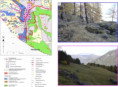
The Laghi Supersynthem (CitationBini et al., 2014) rests unconformably on the bedrock of the valley slopes (LGM glaciation; CitationTantardini, Citation2016; CitationTibaldi & Pasquarè, Citation2008). It consists mostly of massive homogenous to mildly graded and poorly stratified diamictons made up of gravels, cobbles and blocks, with a fair amount of sand and fines. Clasts are usually equidimensional from sub-angular to rounded, rarely faceted. Provenance is both local (paragneiss (TNa), orthogneiss (TNb, GCa), amphibolites (CUa, TNc)) and regional (granitoids, micaschists and metapelites). At the top, decimeter-thick, poorly developed brown soil contains poorly weathered clasts (CitationTantardini, Citation2016), except for amphibolites and migmatites which show thick cortex and occasional arenitization. These sediments are interpreted as ablation tills and are found from 500 m up to 2000 m a.s.l. on the valley slopes. In the Prato del Conte area, glacial deposits are involved by slope failures, as they are bordered by scarps and trenches that dislocate the underneath basement rocks ( and Main Map).
Figure 4. (a) Geological map of the Prato del Conte-Mottaccio area extract from the Main Map. The squares indicate the location of pictures (b) and (c); (b) trench that affects both glacial deposits and bedrock; (c) preserved moraine crests truncated by scarps (right-hand in the photo, corresponding to north-east).
Glacio-fluvial deposits, consisting of fine gravels and sands with minor fines are exposed at few sites at the southern margin of the study area.
The Post-glacial unit unconformably overlays both the bedrock and the Laghi Supersynthem sediments. Five facies associations have been mapped, three of which have been recognized in the subsurface stratigraphy of boreholes S1 and S2 (Main map).
Torrential and alluvial deposits form two terraces in the valley floor, composed by gravels and sands with rounded oblate clasts, sometimes imbricated, fed by the Penninic nappes. The upper terrace deposits of the Mera river interfinger with the debris flow fans from the opposite slopes, while the lower terrace erosion surface cross-cuts all the sedimentary bodies and landforms in the area.
Debris flow deposits form fans (see the list of their lithosomes in the Main Map) at the outreach of the tributaries of the Mera river. These deposits are composed by poorly sorted, chaotic, clast-supported angular to sub-angular, equidimensional to oblate boulders, cobbles, gravels and sand with minor fines. They are recurrently organized in lobate bodies with linear crests, with the largest boulders clustering at their downslope end. Clast petrography is local and coincident with that of the catchment basin and transit areas. Recurrent avulsions of the fan channels are documented by multiple radial traces of entrenched abandoned streams (Main Map). The abandoned fan lobes interfinger with the lower alluvial terrace deposits and are covered by the most recent landslide and slope deposits at the trunk valley center. The active lobes cover the same landslide deposits (Scilano, Vallone Grande and Pigancione fans on the southern valley side and Drana fan on the northern side; Main Map, Geological cross-section B–B′).
Rock fall deposits occur only in the north-eastern portion of the mapped area, made up of orthogneiss (TNb) metric to decametric mainly equidimensional angular boulders with open framework texture, partially eroded and covered by the Valle Vallate debris flow fan (VVF) and eroded by Mera river at the toe (Main Map). This body (MSL – Monte Saragiolo Landslide) has been related to a rock-avalanche originated form the Monte Saragiolo peak (out of map).
Complex landslide deposits spread from the northern to the southern side of the valley. Two main bodies of relevant size have been mapped: one covers the Piuro area, the valley bottom and the southern side up to 1300 m a.s.l., while the other extents east of Belfort up to 1300 m a.s.l. on the northern slope. The bodies meet at the valley center (Main Map).
The stratigraphy of the western body has been observed within archaeological sites of Mot del Castel and Belfort where it covers ancient buildings, and at S1–S2 boreholes. It is composed by clast-supported cobbles with metric boulders mixed to slightly silty sandy gravels, where boulders tend to concentrate mostly in the surficial portions of the deposit. Clasts are mostly angular, from equidimensional to oblate, mainly composed by migmatitic gneiss (GCb – ∼60%), amphibolites and meta-peridotites (CUa, CUb – ∼20%), para- and orthogneisses (TNa, GCa – ∼15%) and minor massive amphibolites (CUa), serpentinites and soapstone (CUb) and allochtonous granitoids and meta-sedimentary rocks. Metric clasts of disrupted, crudely stratified, silty and clayey sands with cobbles and boulders occur at different stratigraphic positions. These are interpreted as glacial deposits involved by sliding. These features point to provenance from the southern valley slope, according to its bedrock petrography and to the occurrence of the mentioned remnants of LGM glacial deposits at Prato del Conte. The color is generally 10YR brown – 5Y olive gray; lenses with deeply weathered clasts of biotite-rich gneiss (GCb, TNa) and amphibolites (CUa) show 5GY greenish gray to reddish colors. Several isolated angular boulders of GCb, CUa and TNa outcrop in the meadows and in the actual Piuro village, suggesting that they are mostly concentrated in the surficial portions of the deposit, as observed within Mot del Castel site. Locally, clusters of boulders form arc-shaped, elongated bumps. Above the elevation of 1000 m a.s.l. on the southern side, these bodies correlate with boulder bodies with open framework texture.
The body surveyed east of Belfort is composed by metric to decametric equidimensional massive angular boulders of orthogneiss (TNb). It shows on average larger grain-size than the western body, less abundant fines and a different composition compared to the western one. At Mot del Castel (Main Map), archaeological excavations showed that the western body overlaps and covers a large hummock that could represent the western termination of the eastern body, where part of the ancient village was built (Main Map, Geological cross-section B–B′). By these relationships we could delimitate the eastern complex landslide body, named Monte Rosa Landslide (MRL), considering its provenance from a scar located on the northern valley slope. The western body (PL) slid from the southern valley slope and covered the MRL. In the valley floor it is covered by the most recent debris flow fan lobes, covered and eroded by the alluvial and torrential deposits of the lower terrace.
Slope deposits are composed by decimetric to metric equidimensional to oblate angular to sub-angular clasts with open-frame texture or clast-supported with sands and minor fines, where clasts petrography is strictly related to the source areas. At the slope feet, these deposits interfinger with the debris flow fan bodies.
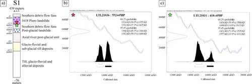
The stratigraphy of the boreholes S1 and S2 and of the pre-existing well B1 (Main map, Well logs interpretation) help to reconstruct the stratigraphic relationships among the Quaternary lithosomes, combining surface and subsurface information (Main map, Geological cross-sections A–A′ and B–B′). At S1, the Pigancione debris flow fan covers at 4 m b.g.s. a ca 8.5 m thick landslide unit comparable to the complex landslide deposits of the western area. Radiocarbon ages have been obtained on woody fragments within the landslide body (552 ± 45 BP at 11.54 m b.g.s.) and within the debris flow deposits immediately underneath (418 ± 45 BP at 14.10 m b.g.s.) (). These data constrain the age of this landslide to the Piuro event, since the sediments just below closely predate the 1618 and the woody fragments within it are slightly older, as it is expected considering that they were redeposited with the host sediments. Another ca 6 m thick landslide body occurs at 17.5 m b.g.s. above a sequence of alluvial sandy gravels (12 m thick), in turn overlaying a sequence of till and intercalated alluvial and glacio-fluvial deposits. At S2 the western landslide body is ca 10 m thick and overlays alluvial deposits. Its textural and compositional features are comparable to the uppermost landslide crossed by S1. B1 borehole shows that the Valle Drana debris flow fan in this position (probably interfingering with slope deposits) lays on the bedrock at 35 m b.g.s.
Figure 5. Radiocarbon ages on two woody fragments within the S1 borehole; (a) interpreted stratigraphy in S1 with the position of the two samples (red star: 11.54 m b.g.s.; green star: 14.10 m b.g.s.); (b) calibration age of the 11.54 m sample; (c) calibration age of the 14.10 m sample (analyses performed at CEDAD Lab – University of Salento).
4.3. Morpho-structural elements
The valley sides are quite asymmetrical, as the northern slopes are steeper than the southern ones. The main foliation of the Tambò Nappe on this side is generally anti dip-slope. The intersection of fracture sets (SE, SO and S dipping) form triangular facets that lead to diffuse slope instability ((a); Main Map, Morpho-structural scheme). On the northern valley side, to the East of the present-day Piuro, scarps, trenches and landslide rims are imposed on a S–SE dipping fracture system, along which typical DSGD-related morphologies dominate ((b)).
Figure 6. (a) View of the northern slope west of Piuro. The blue, red and yellow overlays remark some of the structural surfaces that delimitate the triangular facets; (b) northern slope west of Piuro. Instabilities on this slope are mainly due to a SSE dipping fracture system (blue lines), along which DSGDs (black lines), scarps and scars (e.g. the one of the Monte Rosa Landslide (MRL)) are imposed; (c) panoramic view of the southern slope dominated by DSGDs (black lines) and related morphologies, lined-up with the Gruf Line (GL). Above the GL rugged peaks and some triangular facets (purple overlays) occur. In the Prato del Conte-Mottaccio area, scarps are aligned with the N–S segment of GL.
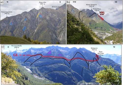
The southern side shows gentler landforms north of the Gruf Line and rugged peaks at higher altitudes, owing to different mechanical behavior and deformation features between the lithotypes of the Chiavenna and Gruf Units. The main foliation is generally steep and dip-slope, with local variations due to decametric-scale undulations. Along the Gruf Line, joint sets developed on the general north-dipping sub-vertical foliation drive instabilities that correlate with this tectonic contact. Mapping the alignment of trenches, release valleys and counterslopes on the lower southern valley side permitted to identify the boundaries of several DSGDs, that determine the convex-up morphologies that dominate the slope ((c)).
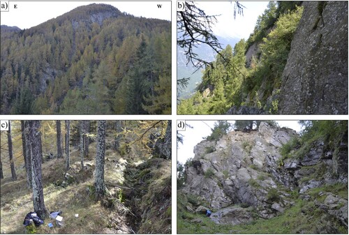
In the Prato del Conte area, the N–S deflection of the Gruf Line corresponds to an incision in the slope on whose sides scarps and trenches are present. It ends up into a scarp where steeply dipping foliated rocks outcrop (). The alignment of scarps defines a higher and a lower landslide scar (Main Map), both set on the incision that remarks the contact between Chiavenna Unit and Gruf Complex.
Figure 7. (a) Panoramic view from Prato del Conte toward the incision that remarks the N–S deflection of the Gruf Line, with the higher scar clearly visible just below the Mottaccio peak; (b) detail of the upper portion of the higher scar made up by the sub-vertical north-east dipping foliation; (c) trench on the western side of the higher scar; (d) highly fractured scarp on the eastern side of the upper scar with sub-vertical north-dipping foliation.
5. Discussion and conclusions: reconstruction of the Piuro 1618 landslide body
As a result of geological mapping, inherited tectonic features have been detected as the major predisposing factors for DSGDs and slope instability on both sides of the valley in the Piuro area. A large number of post-glacial landslides, DSGDs and several debris flow fans characterize the sedimentary fill, the geomorphology and the landscape evolution of the valley. Among the landslide deposits, the correct identification of the Piuro 1618 lithosome (PL) remained uncertain until today, because unequivocal landslide morphologies are lacking and part of these deposits were either covered by recent debris flow fans bodies, eroded and reworked by human restoration works. The geological map here presented permits to support a new and reliable delimitation of the 1618 landslide body, adding further evidence to the correlation with its southern slide scar and to the interpretation of the dynamics of the event. Coming back to the initial open questions:
among the several landslide bodies observed in the Piuro area, which one can be ascribed to the 1618 event?
Two landslide bodies with different features are exposed in the Piuro area. The northern provenance of the Monte Rosa Landslide has been proven, as well as the southern provenance of the several discontinuous bodies representing the exposed remnants of the 1618 event, that cover the seventeenth-century buildings at Mot del Castel and Belfort archaeological sites. The same deposits have been observed in S1 and S2 boreholes, that provide clues also on the thickness of the Piuro Landslide body (Main Map, Geological cross-sections A–A′ and B–B′). The detailed stratigraphic analysis at S1 borehole demonstrates that the landslide body observed below the PL lithosome predates it, because a debris flow fan unit fed from the southern tributaries to the Mera river separates them (Main Map, Well logs interpretation).
(ii) Which is the precise location and geometry of the scar?
The provenance of the PL from the southern slope is documented by the petrography of its bedrock clasts that are mixed with redeposited glacial materials and by the observation of trenches affecting glacial units at Prato del Conte and Mottaccio. These data permit to confirm the location of the 1618 Piuro landslide: two main scarps have been identified at 1450 and 1700 m a.s.l. on the southern slope; the largest and lower one cross-cuts both bedrock and glacial deposits while the upper one involves rocks of the Gruf Complex and Chiavenna Unit, with a sub-vertical, NE-dipping foliation. Right and left flank of the zone of depletion follow the mentioned N–S segment of the Gruf Line.
(iii) Is it possible to estimate the areal extent and volume of the 1618 landslide bodies, in order to fit the inferred scar depletion geometry?
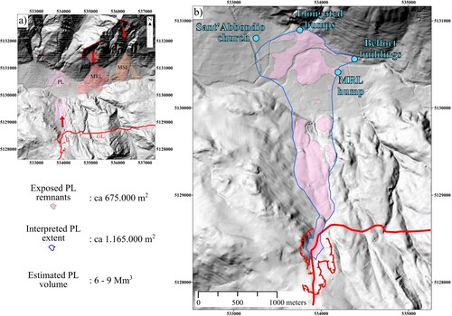
The areal extent of the exposed PL remnants is ca 675,000 m2 considering the valley floor and the slope exposures. However, PL in the valley floor is partly covered by younger deposits that makes it difficult to reconstruct its extent. Uncertainties are particularly strong in the southern and western portions of the Piuro area, where recent debris flow fan lobes cover PL. A qualitative estimate of its extent on the valley bottom is proposed considering some fixed points:
in the Belfort area a building survived the 1618 event, while the landslide leaned to some close buildings. This point locks the north-eastern limit of PL;
a hump of MRL East of Mot del Castel set another limit for PL, that partly covers it;
in its northern portions, PL leans on slope deposits of the northern valley side. Elongated bumps composed by metric boulders of southern provenance represent the toe of the landslide deposit;
on the Drana fan, Sant’Abbondio church survived the landslide but was successively partly swept away by a flood of the Drana torrent in the eighteenth century. The western limit of PL must hence be set east of this point.
This reconstruction of the extent of PL gives an area of ca 1,165,000 m2 () including the buried parts of the landslide body. Considering an average thickness of the PL deposits of 6–9 m derived from the measurements in S1 and S2 (8.5 and 10 m) and at archaeological sites (3–4 m at Mot del Castel, 3–6 m at Belfort), a rough volume estimate between 6 and 9 Mm3 is likely. The reconstruction of the landslide zone of depletion assuming a plausible pre-event topography of the slope gives about 5–6 Mm3 for the involved rock mass. This volume could be incremented including the mass mobilized along the transit zone and the effect of volumetric expansion during deposition.
(iv) Which was the landslide dynamics?
(a) DTM on which mapped landslide deposits and relative detachment zones have been represented; (b) DTM with the interpretation of the areal extent of PL and its detachment zone, according to the fixed points above mentioned.Figure 8. (a) Areal extent of the landslide deposits within the mapped area (Piuro 1618 Landslide (PL), Monte Rosa Landslide (MRS) and Monte Saragiolo Landslide (MSL)) with their correlative scars; (b) interpreted extent of PL in the valley floor with an estimated area of ca 1,165,000 m2. Considering the depth of the deposit and the extent of PL on the slope, an estimation of 6–9 Mm3 is likely.
The presence of two landslide scarps at different elevations suggests that the 1618 landslide may have occurred in two distinct impulses: the first detached from the lower scarp, involving bedrock and glacial sediments, the second, from the upper scarp, involved mostly basement rocks. This reconstruction is supported by the observations on the stratigraphy of the PL deposits, where clasts from the glacial sediments occur in the lower part of the PL stratigraphic sequence while boulders occur mostly at its top.
The paper shows that geological mapping and stratigraphic analyses provide reliable clues to solve the open problems in the study of complex palimpsest landscapes, even in recent/historical settings like the Piuro one. The acquired knowledge on the geological evolution of the study area is fundamental for performing numerical modeling of the landslide (ongoing), which will stimulate causes and effects of the event.
Software
The compilation of the geological map and its database was performed using the Esri ArcGIS® 10.2.1. Geomorphological analyses were carried out using ArcGIS Tools. Final editing was managed with Inkscape (Inkscape Project (2020). Inkscape. Retrieved from https://inkscape.org).
TJOM_A_2057878_Supplementary material
Download PDF (51.1 MB)Disclosure statement
No potential conflict of interest was reported by the author(s).
Data availability statement
Since the data that support the findings of this study are part of a current research project, data will be available from the corresponding author, EP, upon reasonable request.
Additional information
Funding
References
- Albini, P., Bellani, A., & Stucchi, M. (1988). Terremoti e frane nelle Alpi Centrali. In Atti del 7 – Convegno annuale del GNDTS, Rome (Vol. 1, pp. 129–146).
- Bigi, G., Castellarin, A., Coli, M., Dal Piaz, G. V., Sartori, R., Scandone, P., & Vai, G. B. (1990). Structural model of Italy, sheet 1. CNR, Progetto Finalizzato Geodinamica, SELCA Firenze, 1.
- Bini, A., Sciunnach, D., Bersezio, R., Scardia, G., & Tomasi, F. (2014). Note illustrative della Carta Geologica d’Italia alla scala 1:50.000. Foglio 96 – Seregno. ISPRA (in Italian with English abstract).
- Ciancaleoni, L., & Marquer, D. (2008). Late Oligocene to early Miocene lateral extrusion at the eastern border of the Lepontine dome of the central Alps (Bergell and Insubric areas, eastern central Alps). Tectonics, 27(4). https://doi.org/10.1029/2007TC002196
- Galli, A. (2010). Tectono-metamorphic evolution of the Gruf complex (Swiss and Italian Central Alps) [Doctoral dissertation]. ETH Zurich.
- Galli, A., Le Bayon, B., Schmidt, M. W., Burg, J. P., & Reusser, E. (2013). Tectonometamorphic history of the Gruf complex (Central Alps): Exhumation of a granulite–migmatite complex with the Bergell pluton. Swiss Journal of Geosciences, 106(1), 33–62. https://doi.org/10.1007/s00015-013-0120-1
- ISMES. (1994). Studi sismici in alta Valtellina. I quaderni dell’ISMES 336, Bergamo, Italy.
- Marotta, F., Teruggi, S., Achille, C., Vassena, G. P. M., & Fassi, F. (2021). Integrated laser scanner techniques to produce high-resolution DTM of vegetated territory. Remote Sensing, 13(13), 2504. https://doi.org/10.3390/rs13132504
- Scaramellini, G., Kahl, G., & Falappi, G. P. (1988). La frana di Piuro del 1618: storia e immagini di una rovina. Associazione italo-svizzera per gli scavi di Piuro.
- Scaramellini, G., Kahl, G., & Falappi, G. P. (1995). La frana di Piuro del 1618: storia e immagini di una rovina (2a edizione). Associazione italo-svizzera per gli scavi di Piuro.
- Schmid, S. M., Berger, A., Davidson, C., Gieré, R., Hermann, J., Nievergelt, P., Puschnig, A., & Rosenberg, C. L. (1996). The Bergell pluton (Southern Switzerland, Northern Italy): overview accompanying a geological-tectonic map of the intrusion and surrounding country rocks. Schweizerische Mineralogische und Petrographische Mitteilungen, 76(3), 329–355. https://doi.org/10.5169/seals-57705
- Schmid, S. M., & Froitzheim, N. (1993). Oblique slip and block rotation along the Engadine line. Eclogae Geologicae Helvetiae, 86(2), 569–593.
- Schmutz, H. (1976). Der Mafit-Ultramafit-Komplex zwischen Chiavenna und Val Bondasca. Beitr. Geol. Karte Schweiz., N.F. 149, 73.
- Tantardini, D. (2016). Geologia del Quaternario e geomorfologia della bassa Valchiavenna (SO) [Doctoral dissertation]. Università degli Studi di Milano.
- Tibaldi, A., & Pasquarè, F. A. (2008). Quaternary deformations along the ‘Engadine–Gruf tectonic system’, Swiss–Italian Alps. Journal of Quaternary Science: Published for the Quaternary Research Association, 23(5), 475–487. https://doi.org/10.1002/jqs.1150
- Trümpy, R. (1977). The Engadine line: A sinistral wrench fault in the Central Alps. Memoir of the Geological Society of China, 2, 1–12.
- Wenk, H. R. (1984). Brittle-ductile transition zone in the northern Bergell Alps. Geologische Rundschau, 73(1), 419–431. https://doi.org/10.1007/BF01820378