
ABSTRACT
The Last Interglacial period is important for the spread of humans from Africa to Eurasia. Significant wetter climatic conditions allowed humans to live in the present-day arid landscape in Northeastern Africa. However, not only the environment but also other parameters, such as the topography and the availability of good raw material sources, impact past human behaviour. Our mapping with the integration of archaeological sites and environmental archives clarifies regional differences and similarities across Egypt. The Eastern Desert is characterized by a small structured landscape with an above-average occurrence of eligible raw material and it differs from the more homogeneous landscape of the Western Desert with its large palaeo-lakes. The given map allows a more distinct evaluation of regional variabilities for Out-of-Africa’s northern migration route as a complex intermediate scale between a global and local approach to human-environment relations.
1. Introduction
Research on the dispersal of Homo sapiens from Africa to Europe during the Late Pleistocene is a central topic in Quaternary Science, where Geographic Information Systems (GIS) have been increasingly used in recent decades to investigate related questions. Among various other studies, examples from this research context are found in mapping palaeoenvironments on a large scale (e.g. CitationBreeze et al., Citation2016), modelling potential pathways of dispersal (e.g. CitationBeyin et al., Citation2019; CitationCoulthardt et al., Citation2013), or analysing distinct regional environments in the surrounding of archaeological sites (e.g. CitationHensel et al., Citation2019). Interdisciplinary research as part of the Collaborative Research Centre 806 ‘Our Way to Europe’ (CitationLitt et al., Citation2021; CitationRichter et al., Citation2012) has successfully implemented various kinds of these palaeoenvironmental mapping and modelling approaches, which were summarized at the PalaeoMaps Workshop in 2019 (CitationWillmes et al., Citation2020).
The PalaeoMap and the associated study presented here results from a synthesis of regional palaeolandscape proxies and various palaeoenvironmental data of the Last Interglacial (LIG) in Egypt. Northeast Africa is the only land connection between the African and the Eurasian continent and thus is important for the dispersal routes of Homo sapiens. The LIG is a period of particular interest because favourable climatic conditions in Northeast Africa and the Arabian Peninsula allowed humans to disperse across this nowadays hyper-arid Northeast African environment towards the Levant and Southwest-Asia (e.g. CitationGroucutt et al., Citation2015; CitationGroucutt et al., Citation2018; Henselowsky et al., Citation2021; CitationJennings et al., Citation2015; CitationVan Peer, Citation2016). The landscape variability in Egypt during the LIG is achieved by integrating different data sources of Egypt in a GIS environment, following the main ideas of digital geoarchaeology (CitationSiart et al., Citation2018). The input data (climate/biomes, topography, lithology, and raw material resources) represent the major natural landscape parameters of a hunter-gatherer environment during the LIG on a large scale (CitationSchlummer et al., Citation2014).
2. Input data
All used datasets () for the study at hand are freely available, except the geological maps of Egypt. It is a major advantage to use an open-science concept to transmit and apply this approach easily to other regions and time periods, and hence to guarantee a consistent and replicable dataset (CitationWillmes et al., Citation2016). The parameters of this MIS 5e PalaeoMap can be distinguished into layers independent of a temporal dimension (e.g. raw material locations, topography on a meso- and macroscale) and layers that are time-dependent (e.g. climate, ecozones, sea level). The modern administrative borders of Egypt here only constitute artificial boundaries, which were chosen to delimit the area under research and get a consistent and a replicable dataset.
Table 1. List of input datasets.
2.1. Palaeoclimate
The LIG climate data are based on the Community Climate Systems Model version 3.0 (CCSM3), which has a spatial resolution of 1.4° (ca. 150 km at the equator, ca. 140 km in central Egypt) and represents the time between 120 and 130 ka (CitationOtto-Bliesner et al., Citation2006). The downscaled version (Hijmans et al., Citation2005) of the CCSM3-model for the LIG is freely accessible (www.worldclim.org), from which the bioclimatic variables and the temperature and precipitation data are derived.
A Köppen-Geiger classification for the LIG is achieved by the application of a map-algebra-based algorithm, developed by CitationWillmes et al. (Citation2017), to compute the Köppen-Geiger classification based on the WorldClim palaeoclimate LIG dataset. The mapping and location of additional proxy records from Egypt (e.g. botanical and faunal remains from archaeological sites, speleothems, paleohydrological features) serve as baseline for the comparison with the model data.
2.2. Topography and drainage systems
Relief roughness, in combination with elevation, represents the setting for the classification of the overall topography of Egypt, based on a global relief classification dataset. These relief types are calculated on the GTOPO30-DEM with a spatial resolution of 1 km/pixel, in which 15 classes represent the global distribution of all possible relief types based on this classification (CitationMeybeck et al., Citation2001). Sea level changes and adjacent palaeocoastlines are mapped based on the GEBCO2014 dataset (CitationWeatherall et al., Citation2015), which is a compilation of worldwide existing bathymetric datasets with a spatial resolution of 30 arc sec (ca. 1 km at the equator). Here, the underlying data exceptionally good for the Mediterranean Sea and Red Sea. A palaeocoastline for the LIG is set at a maximum sea level of +6 m above the current sea level (CitationGrant et al., Citation2012). Major escaprments are given according to CitationBolten and Bubenzer (Citation2007).
The mapping of major drainage systems derives from the HydroSHED dataset (CitationLehner et al., Citation2006). Thresholds for deriving (hypothetical) river streams are set at a catchment area of 100, 500 km² and 1,000 km². Smaller streams are excluded, representing distinct local landscape settings, which cannot be validated for the total area under investigation. The area of the Great Sandsea is excluded in the derivation of the drainage system, as no proofed information exists about their morphological setting during the LIG (comp. CitationBubenzer & Bolten, Citation2008).
The mapping of Quaternary wadi deposits is based on the geologic maps of Egypt with a scale of 1:500,000 (CitationConoco, Citation1987). This serves as an independent relief mapping of the drainage system and combines the results of the analysis with DEM-derived data. Playa deposits are mapped based on these geological maps (Qy = Chalcedony Cover, Qs = Sabkah deposits, Qp = Quaternary Playa) and manually corrected due to inconsistent syntax between different geological map sheets. All coastal Sabkahs are excluded, as they represent features of the modern coastline.
2.3. Raw material and archaeological sites
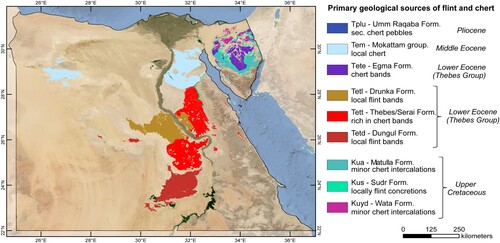
Primary geological sources of flint (respectively chert) are mapped based on the geological maps of Egypt with a scale of 1:500,000 (CitationConoco, Citation1987). Flint, in the primary geological context, occurs in different geological formations of Egypt from the upper Cretaceous to the middle Eocene (). Spatial limitations for mapped raw materials are set to the occurrence of flint-bearing strata on these geologic maps, whereas the distinct geological formations represent the stratigraphic limit of flint occurrences up to different subdivisions of geological stratigraphic stages (CitationConoco, Citation1987). Due to the inconsistent geological mapping of Egypt for different regions, this dataset has the highest spatial resolution for the differentiation of geological strata at this scale. Local flint varieties or even different qualities for the production of stone artefacts can not be distinguished in such a large-scale mapping. The same applies to the differentiation of the numerous types of quartzite and quarzitic sandstone, which were also used for stone artefacts (comp. e.g. CitationWendorf et al., Citation1993).
Table 2. Geological Maps of Egypt 1:500,000 with primary chert and flint sources (CitationCONOCO, Citation1987).
The secondary flint deposits in wadi terraces are identified by combining the primary geological sources and drainage systems with Quaternary wadi deposits. Here, flint-bearing strata with distances to a drainage stream with a minimum catchment area larger than 1000 km² were used as an additional parameter. Regions with a minimum distance of 10 km to both parameters are presented.
The main Egyptian MSA sites were selected and mapped to establish a relationship between Pleistocene humans and their environment during the LIG and provide information on site locations and their position regarding raw material deposits and the corresponding regional surface geology. The criteria for the selection of these archaeological sites () are either a direct dating to the MIS 5 or the technological classification of the stone artefact inventory to the Nubian Complex technology, a regional manifestation of the MSA in Northeast Africa (CitationVan Peer, Citation2016).
Table 3. MSA sites in Egypt dating to MIS 5 or showing comparable technologies in stone tool technology of the Nubian Complex.
3. Results
The results of the different parameters are presented as individual input data of the main map, and they are introduced before the synthesis of the main PalaeoMap highlights the comprehensive data collection.
3.1. Topography
Out of 15 global relief types (CitationMeybeck et al., Citation2001), 11 occur in Egypt, which are dominated by 5 relief types, accounting for at least 5% of Egypt (). The Nile Valley, as a large-scale canyon, divides the Western Desert and the Eastern Desert and marks the border between these two regions. Except for the Eastern Desert and the Sinai Peninsula, where single mountains exceed 2000 m and reach a maximum height of 2642 m above sea level (Mt. Catherine), no high plateaus above 2000 m a.s.l. exist in Egypt. This class does not exceed a minimum of 0.1% of the total land area to be incorporated in the overall relief classes for Egypt. Around two-thirds of Egypt are characterized as plains at a different altitude, mainly between 0 and 500 m (63.8%). Further relief types occur with an intermediate roughness (5 – 20‰) at lower areas (lowlands 0 – 200 m) or intermediate altitudes, defined as platforms (200 – 500 m) and plateaus (>500 m). Whereas the Western Desert is dominated by smooth roughness values (80%), the areas of low and intermediate roughness in the Eastern Desert and the Sinai are more balanced (44% with low roughness, 41% with an intermediate roughness of 5–20‰). Intermediate roughness at an altitude between 200 and 500 m (class 6) is higher in the Eastern Desert and the Sinai compared to the Western Desert and Egypt.
Figure 1. Major relief types in Egypt according to the classification schema of CitationMeybeck et al., Citation2001.
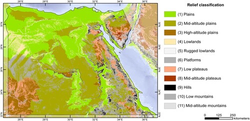
All landforms represent the scale of a macro-relief, where single relief features have a spatial extent of >1km. The current topography of the meso- and macro-relief in Egypt corresponds to the over-regional relief during the LIG. Most dynamic landscapes with a changing topography are active dune fields/sandseas (CitationBubenzer et al., Citation2020), which has been excluded from the interpretation here. Tectonic displacement during the last 130 ka had no significant impact on the scale in question. The impact of the global sea level high stand during MIS 5e also did not change the overall landmass of Egypt in general. The largest changes occur in the Nile Delta. Based on topography, a significant part of the delta was flooded during a sea-level rise of +6 m. Due to thick sediment deposition during the Holocene, the Pleistocene basis of the Nile Delta is submerged up to 13 m below the present surface (CitationPennington et al., Citation2017). Hence, the delta is another regional landscape feature whose appearance in the LIG is unknown.
3.2. Drainage systems and hydrology
The computed drainage lines reveal insights into possible active catchments during MIS 5e, induced by enhanced precipitation (). These streams represent the maximum, but do not mean that all catchments were simultaneously completely active during the LIG. Larger palaeoriver systems occur in the Selima Sandsheet (Western Desert, Egypt), represented by the Tushka watershed system. Their catchments start in northern Sudan and drain towards the large palaeolakes of Bir Sahara/Bir Tarfawi, Bir Kiseiba, Nabta Playa, and Tushka in southern Egypt. Even considering the Great Sandsea as a dune -ree area, where river systems could follow the underlying topography (CitationBubenzer & Bolten, Citation2008), no large-scale river systems exist in Egypt at the scale of the Sahabi and Kufra River System in Libya (CitationCoulthardt et al., Citation2013; CitationGhoneim et al., Citation2012) or the mega watercourses in the central Sahara, which are often interpreted as corridors for human migration (CitationDrake et al., Citation2011). Comparable large river systems (>10,000 km² catchment) in the Egyptian part of the Sahara are, therefore, limited to the Tushka watershed system.
Figure 2. Drainage systems in Egypt based on the HydroSHED dataset (CitationLehner et al., Citation2006) and Quaternary playa and wadi deposits based on geological maps of Egypt 1:500,000 (CitationConoco, Citation1987) with the largest drainage streams (red 1–6) and major palaeolakes (blue 7–10).
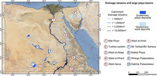
The largest water catchments in the Eastern Desert are Wadi el-Kharit and Wadi Qena, whereas Wadi al-Arish is the most prominent one in the Sinai Peninsula. In contrast to the Western Desert, internal draining in endogenic basins is absent. Hence, large playa basins are nonexistent, but frequently distinct river streamlines filled with Quaternary wadi deposits appear (at Wadi Qena and Wadi el-Arish). These wadi deposits are almost absent in the Western Desert, but Quaternary playa deposits occur more frequently in the Western Desert (e.g. Bir Tarfawi/Bir Sahara, Nabta Playa, Dakhla and Kharga Oasis).
3.3. Raw material
An area of 11% of Egypt is covered with geological formation containing flint-bearing strata. However, there are differences between separate landscape regions such as the Western Desert, the Eastern Desert and the Sinai Peninsula (). Flint-bearing geological strata have the highest percentage about the land area on the Sinai Peninsula (around 31%), and the lowest in the Western Desert (around 8%). For the Eastern Desert, about 15% of flint-bearing strata can be determined. The predominant regional distribution of these formations can be documented in the central Sinai Peninsula, in the northern part of the Eastern Desert (between 26°and 31° N), and in the western part of the Western Desert, north of the Tushka lakes, as well as west of the Nile Valley. Isolated areas of flint-bearing strata also occur north of the Great Sandsea, in the eastern parts of the Siwa Oasis. Most of these formations contain flint in local bands with high regional variabilities. The Thebes formation yields quantitatively the highest amount of flint, which is overall of relative homogenous structure and, therefore, has quite good conditions for the production of stone artefacts (CitationKindermann, Citation2010). Numerous Holocene and Pleistocene archaeological sites on the Egyptian Limestone Plateau and in the adjacent oases underline this impressively (e.g. CitationBarich et al. Citation2014; CitationChiotti et al., 2007; CitationKindermann et al., Citation2006). Large areas covered by this formation exist in the Eastern Desert at the Maaza Plateau and in isolated areas within the Precambrian basement (e.g. Gebel Duwi).
Figure 3. Flint bearing geological strata, based on the geological maps of Egypt 1:500,000 (CitationConoco, Citation1987).
It is evident that additional raw material sources, such as quartz, quartzite, and quarzitic sandstone, were used for the knapping of stone artefacts during the MSA. However, the further differentiation of this material is more difficult, as this raw material cannot be classified so explicitly based on given geological maps and appears geologically more diverse. This is a possible bias in the final interpretation of raw material availability, and regions outside of the flint raw material availability mapped here are by no means considered entirely free of raw material.
3.4. Climate and environments
Total precipitation of the LIG () was above 500 mm/a in the southeastern part of Egypt and decreased towards the north. Here, precipitation of less than 200 mm/a at around 30° N is modelled. In between, precipitation of 500–200 mm/a occurred. The Mediterranean Coast and inland areas, up to a distance of max. 200 km, received rainfalls between 200 and 300 mm/a. The region with summer rainfall, its northern limit, is calculated based on the available monthly precipitation data from the CCSM3-model. The threshold was set at >66% of the total annual rainfall between April and September; winter rainfall as >66% of the total annual rainfall occurs between October and March. The result shows that almost the entire Egypt is influenced by summer rainfall up to 30° N, whereas the northern Mediterranean areas are located in between the northern limit of summer rainfall and the southern limit of winter rainfall and receive year-round rainfall. Distinct winter rainfall is only mapped at the adjacent borders of Egypt at the Libyan coast and in the Levant.
Figure 4. LIG precipitation in Egypt, palaeoclimate model: after CitationOtto-Bliesner et al., 2006; CitationHijmans et al., 2005, www.worldclim.org; with a comparison of annual rainfall during the LIG, based on the CCSM3-model and proxy data: (1) CitationKowalski et al., Citation1989; (1) CitationWendorf et al., Citation1993; (2) CitationKieniewicz & Smith, Citation2009; (3) CitationEl-Shenawy et al., Citation2018; (4) CitationMoeyersons et al., Citation2002.
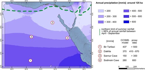
Specific regional climate variability (e.g. topography-induced enhanced rainfall) does not occur in the data of the CCSM3 climate model of this region, and the amount of precipitation is rather a minimum compared to the proxy records (full discussion about the climate data and methodological challenges, see CitationHenselowsky, Citation2019).
3.5. Main palaeomap
The PalaeoMap follows the approach that the Köppen-Keiger classification, as an effective climate classification, represents the supraregional potential environment during the LIG. The classification shows two main classes for Egypt during the LIG. The southern parts represent an arid steppe climate (Bs), whereas the northern parts are classified as an arid desert climate (Bw). Both classes are subdivided into hot and cold desert/steppe (h/k), related to the mean annual temperature below or above 18° C. This is overlaid with the derivation of five major ecozones (CitationHenselowsky, Citation2019): a savannah-like ecozone up to an annual rainfall of 250 mm/a, the Mediterranean woodlands with winter rainfall up to 200 mm/a and the Nile Valley as gallery forests with swamp/marsh-like environment. It is also be assumed that a climatological gradient across similar latitudes from the Western Desert to the Eastern Desert occurred. Higher precipitation existed in the Red Seas Mountains due to orographic rainfall and a noticeable influence of Red Sea Troughs in addition to the monsoonal and Mediterranean rainfall during the LIG (CitationHenselowsky et al., Citation2021). Hence, a montane savannah in the Red Sea Mountains is proposed for areas > 500 m a.s.l.
Further regional differentiation is applied concerning the drainage system, the distribution of flint-bearing limestone, and the calculated core areas with good access to both a higher river course and the flint-bearing strata within a 10 km radius. Landscape zones with the greatest uncertainty at this scale are the large dune areas (Great Sandsea and Farafra Sandsea) and the present-day Nile Delta.
An extensive literature survey revealed dated proxy records of palaeo-hydrological features associated with MIS 5e, as an independent source of information for palaeo-hydrological changes (). Related environmental archives are marked on the main map. A detailed examination of their spatial and temporal context, as well as their significance, is given in CitationHenselowsky (Citation2019). Major archaeological sites on the main map are included as represented in , although many other much smaller sites and surface finds to exist. The smaller inset map illustrates the macro-relief with the larger morphological units in Egypt and their elevation levels.
Table 4. Proxy records for enhanced precipitation in Egypt during MIS 5.
4. Discussion and outlook
According to the current state of knowledge, Northeast Africa offered attractive environmental and climatic conditions for hunters-gatherers during the LIG. Therefore, in addition to the fundamental question, ‘whether’ Pleistocene human used the northern dispersal route Out-of-Africa, individual landscape units of Northeast Africa (here for the present-day Egypt) should be considered in more detail to gain more differentiated regional insights into ‘how’ and ‘where’ humans found particularly good or even ideal conditions, and accordingly interacted with the various landscapes.
The LIG PalaeoMap of Egypt (see supplement material) summarizes the previously discussed parameters and indicates the regional variabilities throughout Egypt. With an extension of about 1100 km from north to south and around 1200 km from east to west, Egypt, as a study region, represents an area, in which large-scale assumptions based on continental environmental changes are generally valid, but provides simultaneously the opportunity to study regional distinct landscape patterns. This is essential, as it is the only way to improve the spatial view and the variabilities of possible, particularly attractive regions on the northern dispersal route, apart from the global scale modelling approaches (cf. CitationTimmermann & Friedrich, Citation2016) or more local, site-specific, approaches. In this context, the chosen scale can characterize the different regions within Egypt well. However, it must also be clearly noted that mapping at this scale cannot represent the individual, local conditions of a single archaeological site in total. CitationHawkins and Kleindienst (Citation2002), for example, have shown that during the MSA the Tarawan chert is widely used in the Dakhla Oasis. However, no flint deposits are mapped within the Tarawan formation at the given scale of the geological maps that were used to derive the map.
The area-wide and comprehensive consideration of biotic and abiotic factors allows a more realistic assessment of the overall landscape units and it leads away from the common idea that primarily climate and water availability are the main factors for human presence in certain areas. It makes it very clear that there are very diverse and attractive habitats, especially outside the Nile Valley, so that it must be emphasized that the consideration of the so-called northern route is by no means limited to the Nile Valley.
The topography of the Eastern Desert, at the scale of the macrorelief, seems to have high attractiveness for humans. Its heterogonous relief offered various special geological-topographical areas and different, small-scale ecological niches. CitationBailey and King (Citation2011) demonstrated the benefits of a complex topography for human behaviour: active tectonics, as a base for a high variability of landscapes, can create different ecological niches, physical barriers or corridors, which can influencethe land-use potential, human settlement, and dispersal. High variability of ecological niches exists in the Eastern Desert. With the given rough topography, water table changes due to climate changes are more effective than flatter topographic landscapes, e.g. the Western Desert. Due to the expected higher precipitation in this region (influence of the Red Sea through the orographic effect), which may also lead to increased precipitation outside the main rainy season, surface water supply is likely to be more permanent and wadi springs may occur on a smaller scale. It also increases the possibility of raw material outcrops, as complex topography and mountainous areas have a more multifaceted geology than flat plains. The northern Eastern Desert and the Sinai Peninsula are also rich in geological formations containing flint; thus, access to raw material for the production of stone artefacts may not have been a limiting factor. In this respect, the Wadi Qena in the north of the Eastern Desert is of specific interest, as it is the largest catchment, and its north–south orientation represents a potential morphometric corridor. The headwaters of Wadi Qena towards the north are free of any morphological barrier. The catchment area drains the Maaza limestone plateau, which contains a high-quality flint of the Thebes formation. Here, large amounts of Quaternary wadi deposits enable an abundant use of flint cobbles as secondary deposits. The MSA sites of the Eastern Desert are generally located close to the flint raw material deposits, at a distance of no more than 10 km from the nearest flint-containing formation or drainage stream with a minimum catchment of 1000 km². Such flint seems to have been quite significant during the MSA (CitationVermeersch et al., Citation1990). Stone artefacts have often been found in direct context with wadi terraces containing flint pebbles, for example, in the Eastern Desert (CitationDittmann, Citation1990; CitationKindermann et al., Citation2018 CitationKöhler et al., Citation2017), in the Nile Valley (CitationChiotti et al., Citation2007; CitationVan Peer et al., Citation2010), in the Western Desert (CitationHawkins & Kleindienst, Citation2002; CitationKindermann et al., Citation2006), as well as on the Sinai Peninsula (CitationGilead, Citation1984). Thus, areas in a narrow radius to primary geological flint sources and Quaternary wadi deposits with secondary sources have been attractive to humans. Such areas occur mainly in the northern Eastern Desert, the Sinai Peninsula, and individual few areas in the Western Desert between the large palaeo-lakes and the Nile Valley.
The Western Desert represents a fundamentally different landscape setting, which had significantly impacted the behaviour of the Pleistocene hunter-gatherer groups. The most important landscape elements are given here by the large palaeo-lakes, where during the LIG, year-round water was available for humans and large fauna (cf. CitationWendorf et al., Citation1993).
Some regions show a generally low attractiveness regarding the mentioned environmental parameters. These regions occur, for example, in the northwestern part of Egypt, between the Egyptian Limestone Plateau and the Qattara Depression, because they have an absence of larger drainage streams and/or a lack of access to raw material can be determined – at least to the flint bearing geological strata. Also, the precipitation and ecozones are less favourable than in the eastern and southern regions. Whether this was ultimately a complete exclusion criterion for humans or to what extent a possible bias in the research history for these regions also represents a lack of sites remains open.
The presented LIG PalaeoMap and the variable input data highlight an enormous regional and environmental diversity in Egypt. The Eastern Desert provides an area where the hypothesis of a heterogeneous environment that might have forced people to be more explorative and mobile could be analyzed in more detail. CitationWren and Costopoulos (Citation2015) have used an agent-based model (ABM) to investigate the relation between environmental knowledge and hominin dispersal. Their results suggest that agents with high environmental knowledge tend to focus on known environmentscompared to agents with less environmental knowledge, which show higher mobility and exploration of new territories. In conclusion, agents with less environmental knowledge are influenced by a higher degree of environmental heterogeneity and have a higher dispersal potential in this ABM (CitationWren & Costopoulos, Citation2015).
Our PalaeoMap, in particular the selected input data, provides an important basis for further modelling approaches, detailed regional site analyses and the scaling up- and down of environmental parameters that could have, most probably, promoted the dispersal of humans from Africa via the Sinai Peninsula into the southern Levant.
Software
All GIS data were handled with ArcMap10.4.1. Cartographic postproduction was done with Adobe Illustrator Package CS4.
Supplemental Material
Download Zip (180.6 MB)Acknowledgments
The authors thank the Egyptian Mineral and Resources Authority (EMRA) for providing us with the digital version of the Geological Maps of Egypt 1:500,000 and for supporting our research in Egypt.
Disclosure statement
No potential conflict of interest was reported by the author(s).
Data availability statement
The GIS-dataset used for the main map are available at the CRC 806 database https://crc806db.uni-koeln.de/start/
Correction Statement
This article was originally published with errors, which have now been corrected in the online version. Please see Correction (https://doi.org/10.1080/17445647.2022.2195285)
Additional information
Funding
References
- Bailey, G., & King, G. C. (2011). Dynamic landscapes and human dispersal patterns: Tectonics, coastlines, and the reconstruction of human habitats. Quaternary Science Reviews, 30(11-12), 1533–15553. https://doi.org/10.1016/j.quasciev.2010.06.019
- Barich, B. E., Lucarini, G., Hamdan, M. A., & Hassan, F. A. (Eds.). (2014). From lake to sand – The archaeology of Farafra oasis, Western Desert, Egypt. All’insegna dell Giglio.
- Beyin, A., Hall, J., & Day, A. (2019). A least Cost path model for hominin dispersal routes out of the East African rift region (Ethiopia) into the Levant. Journal of Archaeological Science: Reports, 23, 763–772. https://doi.org/10.1016/j.jasrep.2018.11.024
- Blackwell, B. A. B., Skinner, A. R., Smith, J. R., Hill, C. L., Churcher, C. S., Kieniewicz, J. M., Adelsberger, K. A., Blickstein, J. I. B., Florentin, J. A., Deely, A. E., & Spillar, K. V. (2017). ESR analyses for herbivore teeth and molluscs from Kharga, Dakhleh, and Bir Tarfawi oases: Constraining water availability and hominin Paleolithic activity in the Western Desert, Egypt. Journal of African Earth Sciences, 136, 216–238. https://doi.org/10.1016/j.jafrearsci.2017.07.007
- Bolten, A., & Bubenzer, O. (2007). Watershed analysis in the Western Desert of Egypt. In O. Bubenzer, A. Bolten, & F. Darius (Eds.), Atlas of cultural and environmental change in arid Africa. Africa Praehistorica 21 (pp. 22–23). Heinrich- Barth-Institut.
- Breeze, P., Groucutt, H. S., Drake, N. A., White, T. S., Jennings, R. P., & Petraglia, M. D. (2016). Palaeohydrological corridors for hominin dispersals in the Middle East ∼250-70,000 years ago. Quaternary Science Reviews, 144, 155–185. https://doi.org/10.1016/j.quascirev.2016.05.012
- Bubenzer, O., & Bolten, A. (2008). Reconstructing palaeodrainage-systems by digital elevation data. In H. Besler (Ed.), The Great Sand Sea in Egypt – formation, dynamics and environmental change-A sediment analytical approach. Developments in Sedimentology 59 (pp. 39–46). Elsevier.
- Bubenzer, O., Embabi, N. S., & Ashour, M. M. (2020). Sand seas and dune field of Egypt. – Geosciences 2020, 10(3), 101. https://doi.org/10.3390/geosciences10030101.
- Caton-Thompson, G. (1952). Kharga Oasis in prehistory. Athlone Press.
- Chiotti, L., Dibble, H. L., Olszewski, D. I., McPherron, S. P., & Schurmans, U. A. (2009). Middle Palaeolithic Lithic Technology from the Western high Desert of Egypt. Journal of Field Archaeology, 34(3), 307–318. https://doi.org/10.1179/009346909791070862
- Chiotti, L., Olszewski, D. I., Dibble, H. L., Mcpherron, S. P., Schurmans, U. A., & Smith, J. R. (2007). Paleolithic Abydos: Reconstructing individual behaviors across the high desert landscape. In Z. Hawass & J. Richards (Eds.), The archaeology and art of ancient Egypt: Essays in honor of David B. O’Connor (pp. 169–183). American University in Cairo Press.
- Close, A. E. (1993). BT-14 Main excavation: The archaeological sequence of the East lake (1986 and 1987 seasons). In F. Wendorf, R. Child & A. Close (Eds.), Egypt during the last Interglacial: The middle paleolithic of Bir Tarfawi and Bir Sahara East (pp. 288–344). Springer US.
- Close, A. E., & Wendorf, F. (1993). E-88-11: The archaeology of the sandsheet. In F. Wendorf, R. Child & A. Close (Eds.), Egypt during the last interglacial: The middle Paleolithic of Bir Tarfawi and Bir Sahara East (pp. 473–487). Springer US.
- Conoco. (1987). Geological maps of Egypt. 1:500,000. Conoco Coral and the Egyptian General Petroleum Corporation, Cairo.
- Coulthardt, T. J., Ramirez, J. A., Barton, N., Rogerson, M., & Brücher, T. (2013). Were rivers flowing across the Sahara during the last interglacial? Implications for human migration trough Africa. PLoS ONE, 8(9), https://doi.org/10.1371/journal.pone.0074834
- Crombie, M. K., Arvidson, R. E., Sturchio, N. C., El Alfy, Z., & Abu Zeid, K. (1997). Age and isotopic constraints on Pleistocene pluvial episodes in the Western Desert, Egypt. Paleogeography, Paleoclimatology, Paleoecology, 130(1–4), 337–355. https://doi.org/10.1016/S0031-0182(96)00134-4
- Dabous, A. A. (2003). Secondary uranium in phosporites and its relation to groundwater in Egypt. Geochemical Journal, 37(4), 413–426. https://doi.org/10.2343/geochemj.37.413
- Dabous, A. A., & Osmond, J. K. (2000). U/Th isotopic study of speleothems from the Wadi Sannur Cavern, Eastern Desert of Egypt. Carbonates Evaporites, 15, 1–6. https://doi.org/10.1007/BF03175643
- Dittmann, A. (1990). Zur paläogeographie der ägyptischen Eastern Desert. Der Aussagewert prähistorischer Besiedlungsspuren für die Rekonstruktion von Paläoklima und Reliefentwicklung. Marburger Geographische Schriften, 116, 174.
- Drake, N. A., Blench, R. M., Armitage, S. J., Bristow, C. S., & White, K. H. (2011). Ancient watercourses and biogeography of the Sahara explain the peopling of the desert. PNAS, 108(2), 458–462. https://doi.org/10.1073/pnas.1012231108
- El-Shenawy, M. I., Kkim, S.-T., Schwarcz, H. P., Asmeron, Y., & Polyak, V. J. (2018). Speleothem evidence for the greening of the Sahara and its implications for the early human dispersal out of sub-Saharan Africa. Quaternary Science Reviews, 1188, 67–76. https://doi.org/10.1016/j.quascirev.2018.03.016
- Gautier, A. (1993). The Middle Paleolithic archaeofaunas from Bir Tarfawi (Western Desert, Egypt). In F. Wendorf, R. Schild, & A. E. Close (Eds.), Egypt during the last interglacial (pp. 121–143). Plenum Press.
- Ghoneim, E., Benedetti, M., & El-Baz, F. (2012). An integrated remote sensing and GIS analysis of the Kufrah paleoriver. Eastern Sahara. Geomorphology, 139-140, 242–257. https://doi.org/10.1016/j.geomorph.2011.10.025.
- Gilead, I. (1984). Palaeolithic sites in northeastern Sinai. Paleorient, 10(1), 135–142. https://doi.org/10.3406/paleo.1984.4354
- Grant, K. M., Rohling, E. J., Bar-Matthews, M., Ayalon, A., Medina-Elizalde, M., Bronk-Ramsey, C., Satow, C., & Roberts, A. P. (2012). Rapid coupling between ice column and polar temperature over the past 150,000 years. Nature, 491(7426), 744–747. https://doi.org/10.1038/nature11593
- Groucutt, H. S., Grün, R., Zalmout, I. A. S., Drake, N. A., Armitage, S. J., Candy, I., Clark-Wilson, R., Louys, J., Breeze, P. S., Duval, M., Buck, L. T., Kivell, T. L., Pomeroy, E., Stephens, N. B., Stock, J. T., Sewart, M., Price, G. J., Kinsley, L., Sung, W. W., … Petraglia, M. D. (2018). Homo sapiens in Arabia by 85,000 years ago. Nature Ecology & Evolution, 800–809. https://doi.org/10.1038/s41559-018-0518-2
- Groucutt, H. S., Petraglia, M. D., Bailey, G., Scerri, E. L. M., Parton, A., Clark-Balzan, L., Jennings, R. P., Lewis, L., Blinkhorn, J., Drake, N. A., Breeze, P. S., Inglis, R. H., Devès, M. H., Meredith-Williams, M., Boivin, N., Thomas, M. G., & Scally, A. (2015). Rethinking the dispersal of Homo sapiens out of Africa. Evolutionary Anthropology, 24(4), 149–164. https://doi.org/10.1002/evan.21455
- Hawkins, A. L., & Kleindienst, M. R. (2002). Lithic Raw material usages during the Middle Stone Age at Dakhleh Oasis, Egypt. Geoarchaeology, 17(6), 601–624. https://doi.org/10.1002/gea.10031
- Hensel, E. A., Bödeker, O., Bubenzer, O., & Vogelsang, R. (2019). Combining geomorphological– hydrological analyses and the location of settlement and raw material sites – a case study on understanding prehistoric human settlement activity in the southwestern Ethiopian highlands. E&G Quaternary Science Journal, 68(2), 201–213. https://doi.org/10.5194/egqsj-68-201-2019
- Henselowsky, F. (2019). Early Late Pleistocene environments in Northeast Africa and their relevance for Anatomically Modern Human dispersal. Dissertation, Universität zu Köln.
- Henselowsky, F., Eichstädter, R., Schröder-Ritzrau, A., Herwartz, D., Almoazamy, A., Frank, N., Kindermann, K., & Bubenzer, O. (2021). Speleothem growth phases in the central Eastern Desert of Egypt reveal enhanced humidity throughout MIS 5. Quaternary International, https://doi.org/10.1016/j.quaint.2021.05.006
- Hijmans, R. J., Cameron, S. E., Parra, J. L., Jones, P. G., & Jarvis, A. (2005). Very high resolution interpolated climate surfaces for global land areas. International Journal of Climatology, 25, 1965–1978. https://doi.org/10.1002/joc.1276
- Jennings, R. P., Singarayer, J., Stone, E. J., Krebs-Kanzow, U., Khon, V., Nisancioglu, K. H., Pfeiffer, M., Zhang, X., Parker, A., Parton, A., Groucutt, H. S., White, T. S., Drake, N. A., & Petraglia, M. D. (2015). The greening of Arabia: Multiple opportunities for human occupation of the Arabian Peninsula during the Late Pleistocene inferred from an ensemble of climate simulations. Quaternary International, 382, 181–199. https://doi.org/10.1016/j.quaint.2015.01.006
- Kieniewicz, J. M., & Smith, J. R. (2009). Paleoenvironmental reconstruction and water balance of a mid-Pleistocene pluvial lake, Dakhleh Oasis, Egypt. GSA Bulletin, 121(7/8), 1154–1171. https://doi.org/10.1130/B26301.1
- Kindermann, K. (2010). Djara. Zur mittelholozänen Besiedlungsgeschichte zwischen Niltal und Oasen (Abu-Muharik-Plateau, Ägypten). Africa Praehistorica, 21, Cologne: Heinrich-Barth-Institut.
- Kindermann, K., Bubenzer, O., Nussbaum, S., Riemer, H., Darius, F., Pöllath, N., & Smettan, U. (2006). Palaeoenvironment and Holocene land-use of djara, Western Desert of Egypt. Quaternary Science Reviews, 25(13-14), 1619–1637. https://doi.org/10.1016/j.quascirev.2005.12.005
- Kindermann, K., Van Peer, P., & Henselowsky, F. (2018). At the lakeshore – An early Nubian Complex site linked with lacustrine sediments (Eastern Desert, Egypt). Quaternary International, 485, 131–139. https://doi.org/10.1016/j.quaint.2017.11.006
- Kleindienst, M. R., Schwarcz, H. P., Nicoll, K. A., Churcher, C. S., Frizano, J., Giegenack, R., & Wisemann, M. F. (2008). Water in the desert: First Report on uranium-series dating of Caton-Thompson’s sequence at refuf pass, Kharga oasis. In M. F. Wisemann (Ed.), The Oasis papers 2. Proceedings of the second International conference of the Dakhleh Oasis project (pp. 25–54). Oxbow Books.
- Köhler, C., Hart, E., & Klaunzer, M. (2017). Wadi el-Sheikh. A new archaeological investigation of ancient Egyptian chert mines. PLOSone, 12(2), https://doi.org/10.1371/journal.pone.0170840
- Kowalski, K., Van Neer, W., Bocheński, Z., Młynarsky, M., Rzebik-Kowalska, B., Szyndlar, Z., Gautier, A., Schild, R., Close, A. E., & Wendorf, F. (1989). A last interglacial fauna from the Eastern Sahara. Quaternary Research, 32(3), 335–341. https://doi.org/10.1016/0033-5894(89)90099-9
- Lehner, B., Verdin, K., & Jarvis, A. (2006). HydroSHEDS Technical Documentation. World Wildlife Fund US, Washington, DC. Available at http://hydrosheds.cr.usgs.gov
- Litt, T., Richter, J., & Schäbitz, F. (Eds.). (2021). The journey of modern humans from Africa to Europe. Culture-environmental interaction and mobility (p. 372). Schweizerbart Science Publishers.
- Mercier, N., Valladas, H., Froget, L., Joron, J.-H., Vermeersch, P. M., Van Peer, P., & Moyersons, J. (1999). Thermoluminescence dating of a Middle Palaeolithic occupation at Sodmein Cave, Red Sea Mountains (Egypt). Journal of Archaeological. Science, 26(11), 1339–1345. https://doi.org/10.1006/jasc.1998.0369
- Meybeck, M., Green, P., & Vorosmarty, C. J. (2001). A New typology for mountains and other relief classes: An application to global continental water resources and population distribution. Mountain Research and Development, 21(1), 34–45. https://doi.org/10.1659/0276-4741(2001)021[0034:ANTFMA]2.0.CO;2
- Moeyersons, J., Vermeersch, P., & Van Peer, P. (2002). Dry cave deposits and their palaeoenvironmental significance during the last 115ka, Sodmein Cave, Red Sea Mountains, Egypt. Quaternary Science Reviews, 21(7), 837–851. https://doi.org/10.1016/S0277-3791(01)00132-9
- Nicoll, K. (2018). A revised chronology for Pleistocene paleolakes and Middle Stone Age – Middle Paleolithic cultural activity at Bir Tarfawi – Bir Sahara in the Egyptian Sahara. Quaternary International, 463, 18–28. https://doi.org/10.1016/j.quaint.2016.08.037
- Olszewski, D. I., Dibble, H. L., McPherron, S. P., Schurmans, U. A., Chiotti, L., & Smith, J. R. (2010). Nubian complex strategies in the Egyptian high desert. Journal of Human Evolution, 59(2), 188–201. https://doi.org/10.1016/j.jhevol.2010.06.001
- Olszewski, D. I., Dibble, H. L., Schurmans, U. A., McPherron, S. P., & Smith, J. R. (2005). High desert paleolithic survey at abydos, Egypt. Journal of Field Archaeology, 30(3), 283–303. https://doi.org/10.1179/009346905791072233
- Osmond, J. K., & Dabous, A. A. (1999). U series Age and origin of Two secondary uranium deposits, central Eastern desert, Egypt. Economic Geology, 94(2), 273–280. https://doi.org/10.2113/gsecongeo.94.2.273
- Otto-Bliesner, B. L., Marshall, S. J., Overpeck, J. T., Miller, G. H., Hu, A., & CAPE Last Interglacial Project members (2006). Simulating Arctic climate warmth and icefield retreat in the Last interglacial. Science, 311(5768), 1751–1753. https://doi.org/10.1126/science.1120808.
- Pennington, B. T., Sturt, F., Wilson, P., Rowland, J., & Brown, A. G. (2017). The fluvial evolution of the Holocene Nile delta. Quaternary Science Reviews, 170, 212–231. https://doi.org/10.1016/j.quascirev.2017.06.017
- Richter, J., Melles, M., & Schäbitz, F. (2012). Temporal and spatial corridors of Homo sapiens sapiens population dynamics during the Late Pleistocene and early holocene. Quaternary International, 274, 1–4. https://doi.org/10.1016/j.quaint.2012.06.009
- Schlummer, M., Hoffmann, T., Dikau, R., Eickmeier, M., Fischer, P., Gerlach, R., Holzkämper, J., Kalis, A. J., Kretschmer, I., Lauer, F., Maier, A., Meesenburg, J., Meurers-Balke, J., Münch, U., Pätzold, S., Steininger, F., Stobbe, A., & Zimmermann, A. (2014). From point to area: Upscaling approaches for late quaternary archaeological and environmental data. Earth-Science Reviews, 131, 22–48. https://doi.org/10.1016/j.earscirev.2014.01.004
- Schmidt, C., Kindermann, K., Van Peer, P., & Bubenzer, O. (2015). Multi-emission luminescence dating of heated chert from the Middle Stone Age sequence at Sodmein Cave (Red Sea Mountains, Egypt). Journal of Archaeological Science, 63, 94–103. https://doi.org/10.1016/j.jas.2015.08.016
- Schwarcz, H. P., & Morowska, L. (1993). Uranium-series dating of carbonates from Bir Tarfawi and Bir Sahara East. In F. Wendorf, R. Schild & A. E. Close (Eds.), Egypt during the last interglacial (pp. 121–143). Plenum Press.
- Siart, C., Forbriger, M., & Bubenzer, O. (2018). Digital Geoarchaeology: bridging the Gap between archaeology, geosciences and computer sciences. In C. Siart, M. Forbriger, & O. Bubenzer (Eds.), Digital geoarchaeology. New techniques for Interdisciplinary human-environmental research (pp. 1–7). Springer.
- Smith, J. R., Giegenack, R., Schwarcz, H. P., McDonald, M. M. A., Kleindienst, M. R., Hawkins, A. L., & Churcher, C. S. (2004). A reconstruction of quaternary pluvial environments and human occupations using stratigraphy and geochronology of fossil-Spring tufas, Kharga Oasis, Egypt. Geoarchaeology: An International Journal, 19(5), 407–439. https://doi.org/10.1002/gea.20004
- Smith, J. R., Hawkins, A. L., Asmerom, Y., Polyak, V., & Giegengack, R. (2007). New age constraints on the Middle Stone Age occupations of Kharga Oasis, Western Desert, Egypt. Journal of Human Evolution, 52(6), 690–701. https://doi.org/10.1016/j.jhevol.2007.01.004
- Timmermann, A., & Friedrich, T. (2016). Late Pleistocene climate drivers of early human migration. Nature, 538(7623), 92–95. https://doi.org/10.1038/nature19365
- Van Peer, P. (1998). The nile corridor and the out of Africa model. An examination of the archaeological record. Current Anthropology, 39(Supplement), 115–140.
- Van Peer, P. (2016). Technological systems, population dynamics and historical process in the MSA of Northern Africa. In S. C. Jones, & B. A. Stewart (Eds.), Africa from MIS 6-2: Population dynamics and paleoenvironments. (pp. 147–159). Springer.
- Van Peer, P., Vermeersch, P. M., & Paulissen, E. (2010). Chert Quarrying, lithic technology and a modern human burial at the paleolithic site of Taramsa 1, upper Egypt. Leuven University Press.
- Vermeersch, P. M., Paulissen, E., & Van Peer, P. (1990). Palaeolithic chert exploitation in the limestone stretch of the Egyptian Nile Valley. The African Archaeological Review, 8(1), 77–102. https://doi.org/10.1007/BF01116872
- Vermeersch, P. M., Van Peer, P., & Paulissen, E. (2002a). Middle Palaeolithic Chert Quarrying at Nazlet Khater 1. In P. M. Vermeersch (Ed.), Palaeolithic quarrying sites in upper and middle Egypt, Egyptian Prehistory monographs (pp. 27–78). Leuven University Press.
- Vermeersch, P. M., Van Peer, P., & Paulissen, E. (2002b). Middle Palaeolithic Chert Quarrying at Nazlet Khater 3. In P. M. Vermeersch (Ed.), Palaeolithic quarrying sites in upper and middle Egypt Egyptian Prehistory monographs (pp. 99–112). Leuven University Press.
- Weatherall, P., Marks, K. M., Jakobsson, M., Schmitt, T., Tani, S., Arndt, J. E., Rovere, M., Chayes, D., Ferrini, V., & Wigley, W. (2015). A new digital bathymetric model of the world's ocean. Earth and Space Science, 2(8), 331–345. https://doi.org/10.1002/2015EA000107
- Wendorf, F., Schild, R., Close, A. E., & Associates (1993). Egypt during the Last Interglacial. The Middle Paleolithic of Bir Tarfawi and Bir Sahara east. Plenum Press.
- Willmes, C., Becker, D., Brocks, S., Hütt, C., & Bareth, G. (2017). High-resolution Köppen-Geiger classifications of paleoclimate simulations. Transactions in GIS, 21(1), 57–73. https://doi.org/10.1111/tgis.12187
- Willmes, C., Becker, D., Verheul, J., Yener, Y., Zickel, M., Bolten, A., Bubenzer, O., & Bareth, G. (2016). An open Science approach to GIS-based paleoenvironment data. ISPRS Annals of the Photogrammetry, Remote Sensing and Spatial Information Sciences, III-2, 159–164. https://doi.org/10.5194/isprs-annals-III-2-159-2016
- Willmes, C., Niedzolka, K., Serbe, B., Grimm, S., Groß, D., Miebach, A., Märker, M., Henselowsky, F., Gamisch, A., Rostami, M., Mateos, A., Rodriguez, J., Limberg, H., Schmidt, I., Müller, M., Hölzchen, E., Holthausen, M., Klein, K., Wegener, C., … Bareth, G. (2020). State of the art in paleoenvironment mapping for modelling applications in archaeology – summary, conclusions and future directions from the PaleoMaps workshop. Quaternary, 3(2), 13. https://doi.org/10.3390/quat3020013.
- Wren, C. D., & Costopoulos, A. (2015). Does environmental knowledge inhibit hominin dispersal? Human Biology, 87(3), 205–223. https://doi.org/10.13110/humanbiology.87.3.0205