
ABSTRACT
Landscape preservation strongly depends on exploration and knowledge of its history and evolution. The acquisition and the analysis of geological and geomorphological features are basic and useful tools to identify the touristic potential and the anthropic impact of a territory. This study aims to enhance the knowledge of the natural and cultural heritage of an area of the Daunia Mts between the towns of Alberona and Faeto, Southern Italy, marked by neglect and abandonment, through the drafting of a geomorphological map and the proposal of geotourist itineraries and routes. The results highlight the potential competitiveness and attractiveness of the study area by contributing to the promotion of a sustainable development of a marginal territory. Such data may encourage a form of fruition that promotes knowledge, appreciation, and environmental awareness, in a fragile territorial context.
1. Introduction
The exploration of landscape, the knowledge of its history and evolution, and authentic naturalistic experiences are the key to promote tourism of a territory and the integration of geological and geomorphological heritage in touristic itineraries represents a way to enrich the touristic offer and landscape preservation. In this sense, geotourism contributes to the understanding of territories and can trigger a virtuous mechanism, allowing populations to benefit from the sustainable use of resources and reinvest in the management and protection of geodiversity (CitationGray, 2019; CitationLavecchia et al., 2003; CitationMessedi et al., 2021; CitationNotarpietro et al., 2016; CitationPiacentini et al., 2011; CitationTropeano & Schiattarella, 2019; CitationWang et al., 2019).
Daunia Mts represent a territory rich in signs impressed by human activity and characterized by valuable naturalistic and cultural elements. However, several areas are marked by neglect and abandonment mainly due to modern urbanization processes and consistent demographic exodus, with consequent tendency to population aging, as well as recurrent natural disasters and anthropogenic transformation of natural surfaces. Moreover, these areas are territorially isolated, being mountainous and with a rough topography that does not allow to ensure adequate internal connections (CitationW.AA., 2017). The components of the heritage of resources that can be used today are still disconnected from one another. So far, there are no systematic activities to promote tourism and integrated offerings, with a little knowledge of the area as a tourist destination in the regional and national context.
The choice to investigate this issue in such a depopulated area arose from the conviction that the internal areas of Southern Italy must project themselves into the future by launching autonomous development mechanisms, together with proper management of the territory, and that their possible development may represent a paradigmatic model for other Mediterranean and European countries (CitationAzzilonna et al., 2021). Greater visibility of a marginal area may be reached through the enhancement of environmental and cultural resources, but the socio-economic development of that area should occur by promoting a form of sustainable tourism able to conjugate fruition, environmental safeguard, valorization of the historical-cultural roots of the territory, and the awareness by resident people to live in an extremely valuable area (CitationViganoni, 1997).
Considering recent events that have involved geotourists in different areas of Italy (e.g. the flash flood of 20th August 2018, in the Raganello River gorge – Calabria, Southern Italy – that caused the death and the wounding of many people), it is important to emphasize that the comprehension of natural hazards affecting the territory, compared to the cultural and landscape resources, may help to recognize the intrinsic potential of the study area. In this sense, we referred to the 2030 Agenda for Sustainable Development SDG targets 8.9, 11.4, 15.4 with a focus on sustainable tourism that creates jobs and promotes local culture and products, the world’s cultural and natural heritage safeguard, and the conservation of mountain ecosystems.
This work started from a geomorphological survey of the study area carried out in 2020–2021. The attached map was drawn in GIS environment to support the integrated analysis of the main geomorphological features of the area for their subsequent inclusion within geotourist itineraries.
2. Geographical and geological settings
The Daunia Mts develop in a narrow strip in the north-westernmost part of Apulia, corresponding to the eastern area of the Apennines, on the borders with Molise, Campania, and Basilicata. They border to the west and southwest of the Tavoliere di Puglia plain, a flatland organized in a staircase of terraces joining the Adriatic Sea. The maximum elevation of the Daunia Mts is reached at 1151 a.s.l. (Mt. Cornacchia).
From a geological viewpoint, the north-western sector of the Apulia region extends over structural domains belonging to the foreland thrust belt system of the southern Apennines. From west to east, the system includes three structural domains: the Apennines Chain, the Bradano Trough, and the Apulian Foreland (CitationCorrado et al., 2017). The study area is included in the frontal (i.e. eastern) sector of the chain and constitutes the Daunia tectonic unit (CitationDazzaro & Rapisardi, 1996).
The foredeep sector of the Tavoliere di Puglia consists of a succession of marly clays, silty clays, and grey-blue clays with sandy lenses, belonging to the Argille subappennine formation (middle Pliocene - lower Pleistocene). Seven synthems, made of continental and marine terraced units, are grouped into the Tavoliere di Puglia Supersynthem and lie by erosional contacts on the older marine clays of the Argille subappennine Fm. (CitationGioia et al., 2014; CitationMoretti et al., 2010; CitationSpalluto et al., 2021). The morphological features of the chain front reflect the lithostratigraphic and tectonic characters of the area: in correspondence with the outcrop of the calcareous Flysch di Faeto Fm., the relief is more articulated and harsher, contrary to the easternmost areas of the chain, made of pelitic-marly successions of the Flysch Rosso Fm., where the landforms are smoother, as they are more easily modelled by erosive processes (CitationPieri et al., 2011).
A conspicuous number of springs, fed by the hydrogeological complex of Daunia Mts, are particularly concentrated in the surroundings of Alberona (i.e. Fontanelle, Pisciarelli, Muta, Conca) to the west of the watershed between the Salsola stream and the Fortore River catchments.
3. Methods
The geomorphological map was carried out in GIS environment using QGIS 3.16.0 (https://qgis.org/it/site/) and ArcGIS 10.4, which allowed analysing the study area to draw the routes and to evaluate the potential tourism of the investigated places.
The cartographic representation of the main geomorphological elements was carried out according to the criteria and guidelines for the national geomorphological mapping of the Quaderni del Servizio Geologico Nazionale (CitationW.AA., 2018), with the aim to provide an overall view of the study area and the tools useful for the landforms recognition and understanding. The study of landforms and processes was supported by a wide-ranging bibliography for the territory of Southern Italy (even outside the investigated area) on the different landscape features (CitationGiano et al., 2018; CitationMartino et al., 2009; CitationSantangelo et al., 2013; CitationSchiattarella et al., 2013; among others).
Border definition of the investigated area was determined by considering all the potentially relevant elements that could provide an exhaustive picture of the territorial context ().
Figure 1. Study area with the analysed sub-basins. Base map: Digital Terrain Model (hillshade).
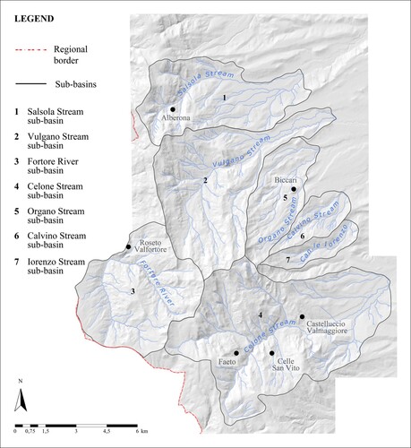
Since the rivers are the main morphogenetic agents of the landscape, all the fluvial forms were mapped, starting from the recognition and delimitation of seven sub-basins.
As surface and terrain models represent reliable tools for analysing landforms and monitoring geomorphological processes (CitationZingaro et al., 2021), the Digital Terrain Model (a hillshade model) was created and used as the basemap, and flow accumulation and flow direction were used to determine the catchment areas and to extract the channel network layers. The subsequent hierarchization was carried out following the Horton-Strahler ordering scheme. Flat surfaces (with a slope angle less than 6 degrees), landslide areas, debris cones, anthropogenic forms, and geosites were mapped on GIS platform using aerial photos.
Landslide Density (LD index) was computed as it is an important indicator of territorial vulnerability. It is worth noting that the sub-basins areas do not correspond to the entire study area (see attached map) because several elements are located outside the analysed catchments.
Topographic and stream profiles were extracted by using an 8 m-resolution Digital Terrain Model (DTM). Official topographic maps by the Italian ‘Istituto Geografico Militare’ (IGM) at 1:25,000 scale, and regional cartography at 1:5000 scale, were used for both the 2020–2021 field survey and to map landforms by remote methods (mainly by photo-aerial and satellite images analysis). Geological maps (sheet 407 ‘San Bartolomeo in Galdo’ at 1:50,000 scale, and sheets 163 ‘Lucera’ and 174 ‘Ariano Irpino’ at 1:100,000 scale, from the Carta Geologica d’Italia) were also used to support the analysis of physical landscape. Data are projected in the geodetic reference system of UTM 33N - WGS84 (EPSG: 32633).
GIS analyses allowed us to identify the potential itineraries. The most valuable geotouristic areas were selected based on the following criteria: (i) the visual impact of the places showing relevant landforms; (ii) the capacity of the natural and anthropogenic elements to stimulate the curiosity of the visitor (geotourist attractors); (iii) the possibility of recognition of the different geomorphological features; (iv) the merging the natural heritage with the cultural landscape components.
4. Results
We mapped an area of about 250 km² corresponding to a portion of the Daunia Mts, southern Apennines, at 1:30,000 scale. From the border definition of the study area an irregular shape was obtained: in the south-western sector, the map follows the regional limit and then the line of the south-west hydrographic basin; the rest of the area is delimited by arbitrarily imposed limits.
4.1. Geomorphological features
4.1.1. Flat surfaces
At higher altitudes, sub-horizontal surfaces with a slope angle not exceeding 6°, cutting the stratigraphic successions, have been identified and mapped. These paleosurfaces are distributed along the whole range, at variable heights. Most of the western ones show a preferential trend, with a S-SE prevalent orientation. The remaining part shows a certain causality in dip direction. Moreover, some depositional surfaces of limited extension have been found in the study area. Some of these have been localized along some rivers and others in correspondence of river stretches with a weaker slope, at the outlets of the main valleys.
From 500 m a.s.l., along the front of the Daunia Mts, the edges of different orders of alluvial terraced deposits of the Supersynthem of the Tavoliere di Puglia (Middle-Upper Pleistocene) are present, lying on the Argille subappennine Fm.; those of greater extension has been found in the northernmost part of the study area and coincide with the Lucera Synthem, the oldest here detected (CitationGioia et al., 2014). Locally, strips of fluvial terraces of modest heights, directly facing on streams engraved in the geological units of the chain front, are also present. They represent the product of the interplay between the regional uplift that affected the Bradano Trough and the front of the Apennine chain during the Quaternary, and the coeval sea-level changes. Their young age can be deduced by their elevation of a few metres above the present-day thalwegs. It is worth noting that some of these terraced surfaces show archaeological evidence of various types of settlements, such as the village of Celle San Vito or some industrial sites.
4.1.2. Fluvial network
The hydrographical sub-basins are narrow and elongated (except for the sub-basin observed to the SW of the study area), with stream network of the III and IV order. The main streams, mostly of torrential nature, are (from north to south): Salsola, Vulgano, and Celone streams (tributaries of Candelaro River) flowing from west to east and Fortore River, which develops to the west of the watershed set along the alignment Mt. Vento (1056) – Mt. Stillo (1010 m) and flows in the E–W direction.
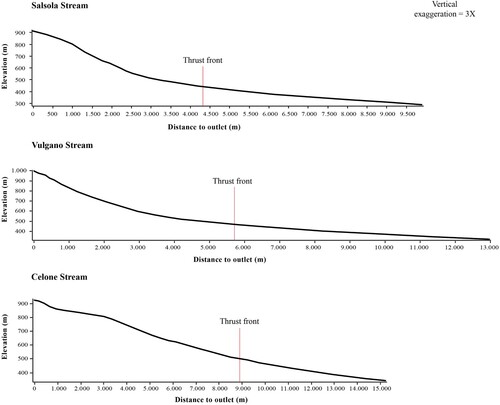
The longitudinal profiles of the main streams show a slight convexity in the upstream areas and then an inflection of the concave curve near the front of the chain, at the boundary between the Daunia Unit and the Bradano Trough. In the longitudinal profile of Celone Stream (between 850 and 820 m a.s.l.), the presence of a slight fluvial knickpoint coinciding with a sub-horizontal surface has been detected, as evidence of the variation of the base level ().
Figure 2. Longitudinal profiles of the main streams (vertical exaggeration = 3X).
In general, rivers form trellis-like networks, conditioned by the structure of the context in which they are located. The observation of the hydrographic network has led to identify, in correspondence with the beds of some lower order streams, possible phenomena of regressive erosion, due to structural factors or changes in the base level. Some cases are observed to the south of Mt. del Forno and Toppo Casone, where erosions of this type are generated by tributaries of the I order of Fortore River; others occur between Mt. Cornacchia and Mt. Sidone and to the south of Mt. San Vito. In two cases the valley tracts transversally cut the structures: in the first case, Vulgano Stream flows embedded between Mt. Tuoro (668 m) and Mt. Elena (693 m); in the second case, the Celone Stream runs along a valley stretch to the south of the Castelluccio Valmaggiore village, cutting across the structure, with a braided course.
The presence of incised valleys has been detected in the rocks of the Daunia Tectonic Unit. Flat-bottomed valleys in the chain area are exiguous or absent. Wider flat-bottomed valleys are detectable in the easternmost sector of the study area, where more recent units crop out, streams assume a straighter course, and valleys are incised only in the initial foothill sections. To the north of Faeto and to the south of Mt. Cornacchia a wide flat-bottomed valley develops, re-incised by Foce Stream.
Moreover, many areas are interested in sheet washing phenomena, mostly at the top of the slopes and distributed on the whole territory.
4.1.3. Landslides and debris cones
The study area is dominated by landslides of different sizes and cinematics (aged between the Upper Pleistocene and the Holocene), particularly insisting in the outcrop areas of the Daunia Formation.
Many of the landslide areas are cut at their foot by streams that have carved the body, shaping valleys of small dimensions.
In many cases, the landslide bodies are set along the course of the river channels, sometimes conditioning their flow. Moreover, a large part of landslides is constituted by distinct bodies converging in downstream coalescing stretch. It is more unusual in the south-western sector of the study area, near Roseto Valfortore, where landslides are smaller in size. This area is not included among those with geomorphological hazard mapped in the official hazard maps. In other cases, some more recent landslide bodies may have set on older ones.
The mass movements in the locality of Lame Giantomaso, near Alberona, and in the locality of Lame Lumelle, near Celle San Vito, both affecting the Flysch Rosso formation, constitute cases of landslide reactivations (CitationSpalluto et al., 2021). The calculation of landslide density (LD) allowed us to observe that there is no direct relationship between landslide areas and sub-basin areas. An inversion can be noted in the relationship between LD and the area occurring for the Fortore River basin, where landslide density occurs at about 3% with respect to a total area of 26.616 km², the lowest compared to the remaining investigated area. The highest rate of landslide has been found in the sub-basin of Organo Stream (more than 6% on an area of about 12.7 km²), considering that a similar value has been found in the Salsola Stream sub-basin in relationship to a greater extension of the area (23.103 km²). About 7.8% of landslides (the highest percentage of the entire area) are detectable in the Vulgano Stream sub-basin, for an area of 33.485 km². For a total of 147.54 km² the landslide areas are just under 6% (). By measuring the landslide occurrence in relation to the entire mapped area (245.4 km²) a landslide density of about 4.5% has been obtained ().
Table 1. Landslide density (LD) in relation to the total area of investigated sub-basins and to the entire study area.
Debris cones, with a weak slope and flattened summit surfaces of modest extension, have been recognized near some landslide bodies of greater extension by consulting geological maps.
4.1.4. Anthropogenic landforms
Few anthropically modified landforms are present in the study area. Among such forms of anthropogenic origin, some river stretches and flat surfaces affected by industrial settlements have been mapped.
The area includes protected areas and/or areas of cultural importance (Site of Community Importance – SCI, archaeological areas, geosites) covering over 30% of the entire investigated territory (). In particular, we can observe that a large part of the study area corresponds to the SCI Monte Cornacchia-Bosco Faeto (CitationLavarra et al., 2014; Piano Paesaggistico Territoriale Regionale – PPTR), which extends for about 69.5 km² (through Alberona, Biccari, Castelluccio Valmaggiore, Celle di San Vito, Faeto and Roseto Valfortore).
Figure 3. Protected and/or culturally relevant areas in the investigated portion of the Daunia Mts.
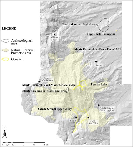
Various geosites have been found in the investigated area (covering a total of 4.46 km²), in a good state of preservation: Celone Stream upper valley, Monte Sidone and Monte Cornacchia Ridge, Pescara Lake, and Toppo della Testuggine. Identification, geographic and descriptive information were derived from the regional catalog consulting http://www.geositipuglia.eu/ website ().
Table 2. Information about investigated geosites of the study area.
4.2. Itineraries
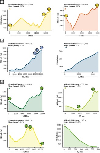
Based on the collected data, three itineraries have been identified. They pass through the SCI (access to the site is regulated by Piano di Gestione del SIC Monte Cornacchia – Bosco Faeto – IT9110003):
Itinerary 1. From Alberona to Monte Saraceno through the Fortore River valley;
Itinerary 2. From Tertiveri site to the viewpoint towards the Tavoliere lowlands;
Itinerary 3. From Bosco di Faeto to Monte Cornacchia along the Celone Stream upper valley.
Each itinerary proposes alternative routes (), considering the possibility to stay overnight or to plan daily round trips. In addition, the itineraries can be interweaved. Pedestrian activities (trekking) and the use of bicycles are planned (bike sharing service is provided), particularly along the Sentieri Frassati and the short stretch of the southern Via Francigena, which guarantee a direct contact with nature, as geotourism provides. The routes to be followed by car coincide with some provincial roads and, in most cases, with panoramic roads. Further, routes cross many villages, which still retain traces of past ages and boast some important awards: Alberona has received the Bandiera Arancione recognition for tourist-environmental quality and, together with Roseto Valfortore, has been included in the list of the most beautiful Italian villages (I Borghi più belli d’Italia), for valuable historical and artistic elements. Additionally, Celle San Vito and Faeto represent the only Franco-Provençal minorities in Southern Italy.
Figure 4. Elevation profiles of itineraries routes.
5. Discussion and conclusions
The investigated segment of Daunia Mts represents a marginal territory, characterized by neglect and abandonment, but also by important elements of naturalistic and cultural value.
The geomorphological map highlights landforms and long-term geomorphological processes of the area. The analysis of the collected data demonstrates the widespread presence of paleosurfaces, included in the context of the geological evolution of the area.
Some depositional surfaces may represent areas of fluvial widening, due to aggradation of some stream segments. Others may have a genesis connected to phenomena of fluvial flooding, at the end of which, after the re-entry of the streams into its bed, the abandoned detritus operated a filling of those areas located along the fluvial courses. The results demonstrate that the surfaces do not present slopes such as to suggest that they could be terraced surfaces but are completely levelled at the current riverbed level.
It is worthy of note that, among flat surfaces, some are anthropically modified and this observation can confirm the existing fragmentation of natural surfaces constitution and continuity.
The setting of the hydrographic network suggests that the Quaternary tectonic evolution related to the outermost thrust of the Daunia Apennine, which brings the Daunia Tectonic Unit on the Bradano Trough Unit (CitationDazzaro et al., 1988), may have conditioned the positioning of the watershed in the outermost sector of the chain and consequently the development of the fluvial net (length of the streams and width of the feeding zone) in the northernmost sector of the investigated area, as CitationPieri et al. (2011) claims.
The longitudinal river profiles show that the stream segments not presenting an equilibrium condition coincide with a portion of the chain that is supposed to be currently affected by tectonic uplift, probably occurring at a discrete speed, if we consider that the streams have not yet adjusted their profile. The presence of knickpoints in the upstream area of Celone Stream gives evidence of base level variations.
Such results indicate that tectonic uplift led to an accentuation of the linear erosion, with a consequent deepening of the riverbeds and the formation of V-shaped valleys in the successions of the Daunia Tectonic Unit. Another evidence of an active tectonic uplift might be given by the exiguous presence of flat-bottomed valleys in the chain area.
It is worth noting that despite the strong incision affecting the chain front, no alluvial cone could be found in this area. This fact would prompt some considerations: assuming that streams have enough energy to allow debris materials to be picked up and taken over, the lack of deposition may suggest that debris is rapidly transported and therefore that sediment removal capacity exceeds inputs; on the other hand, we assume that the quantity of inputs is rather small, in relation to various factors, including for example the occasional regime characterizing mountain streams or, in some cases, the role played by the residual forest cover in controlling and limiting the mobilization and transport of debris. Furthermore, the collected data show the presence of only a few modified river stretches, as demonstration of a limited human activity impact on rivers in this area.
The shapes of the landscape reflect the main lithology and are linked to a geomorphological context in continuous evolution, dominated by landslides of different sizes. The shapes of the relief, the considerable slopes, in addition to the geological and structural conditions of the area, seem to represent the main causes of landslides. Moreover, the observation of the area helps us to consider, once again, the role played by the vegetal cover in relation to the stability of a land: remember that, over time, the original forest cover in these areas has been degraded and destroyed by man, leaving strips of land bare and contributing to accentuate the landslide phenomena.
We show that the presence of significant landforms and landscapes is relevant to the valorization of the territory and the promotion of a sustainable touristic policy. As proved, although the investigated area presents a certain type of instability connected to the landslide phenomenon (LD = 4.46%), representing a risk factor not to be underestimated, it is important to consider the percentage of the territory under protection (31.1%) and the presence of other valuable elements. This makes it possible to reconsider the territory starting from its intrinsic potential and to base future development on it. Yet, it is necessary to take into account natural risks affecting the study area, although it could not represent an inhibitory factor for geotourism. Our results are essential to understand that the geomorphological hazard is compatible with the fruition of cultural and landscape resources of Daunia Mts.
Geo-itineraries proposal represents the way to re-establish links between the various components, strengthening physical elements and historical-cultural roots. In this way, we demonstrate that the territory can offer touristic experiences of visiting and learning about its beauty through direct contact with nature and, improving the usability, can raise awareness of local communities, in line with the geotourism purposes. In this sense, such itineraries become an integrated offer of naturalistic, cultural, sporting, and outdoor activities, improving the welfare and livelihoods of local communities by supporting their local economies (SDG target 8.9). The mapped itineraries cross relevant paths (Sentieri Frassati and Via Francigena), protected areas, geological structures, and geomorphological features, so their fruition aims to respect biodiversity, wildlife, and mountain ecosystems (SDG targets 11.4, 15.4), in terms of sustainability. The results of our study demonstrate that, although the mapped area (about 250 km2) shows 4.46% of landslide density, it has a rich heritage of historical, cultural, and environmental resources (31.1%) and the geological and geomorphological elements can represent important resources for sustainable development of the territory. The enhancement of the landscape, in fact, just represents a key to protect and safeguard the natural and cultural heritage of this marginal area, supporting sustainable tourism activities and local economies.
Software
QGIS 3.16.0 and ArcMap 10.4 were used for the construction of the main map and for the drawing up of itineraries. The map was imported into Adobe Illustrator CC 2018 for graphic adjustments and the final layout.
TJOM_A_2076623_Supplementary material
Download PDF (9.1 MB)Data availability statement (DAS)
The 8 m-resolution Digital Terrain Models (DTM) used as basemap is free downloaded from http://www.sit.puglia.it The data supporting the findings of this study are available from the corresponding author, upon reasonable request.
Disclosure statement
No potential conflict of interest was reported by the author(s).
References
- Azzilonna, V., Corrado, G., Gioia, D., Albolino, O., & Schiattarella, M. (2021). La valorizzazione del patrimonio naturalistico e culturale del territorio di Grassano e Grottole in Basilicata per un turismo sostenibile: Analisi geomorfologica e GIS per proposte di itinerari. Documenti Geografici, 2, 183–204. https://doi.org/10.19246/DOCUGEO2281-7549/202102_13
- Corrado, G., Di Leo, P., Giannandrea, P., & Schiattarella, M. (2017). Constraints on the dispersal of Mt. Vulture pyroclastic products: Implications to mid-Pleistocene climate conditions in the foredeep domain of southern Italy. Géomorphologie: Relief, Processus, Environnement, 23(2), 171–182. https://doi.org/10.4000/geomorphologie.11731
- Dazzaro, L., Di Nocera, S., Pescatore, T., Rapisardi, R., Romeo, M., Russo, B., Senatore, M. R., & Torre, M. (1988). Geologia del margine della catena Appenninica fra il F. Fortore ed il T. Calaggio (Monti della Daunia – Appennino meridionale). Memorie della Società geologica italiana, 41, 411–422.
- Dazzaro, L., & Rapisardi, L. (1996). Schema geologico del margine appenninico tra il F. Fortore e il F. Ofanto. Memorie della Società geologica italiana, 51, 143–147.
- Giano, S. I., Mecca, L., Pascale, S., & Schiattarella, M. (2018). Morphometric analysis of the thrust front of the Lucanian Appennine, southern Italy. Geografia Fisica e Dinamica Quaternaria, 41, 67–81. https://doi.org/10.4461/GFDQ.2018.41.5
- Gioia, D., Gallicchio, S., Moretti, M., & Schiattarella, M. (2014). Landscape response to tectonic and climatic forcing in the foredeep of the southern Apennines, Italy: Insights from Quaternary stratigraphy, quantitative geomorphic analysis, and denudation rate proxies. Earth Surface Processes and Landforms, 39(6), 814–835. https://doi.org/10.1002/esp.3544
- Gray, M. (2019). Geodiversity, geoheritage and geoconservation for society. International Journal of Geoheritage and Parks, 7(4), 226–236. https://doi.org/10.1016/j.ijgeop.2019.11.001
- Lavarra, P., Angelini, P., Augello, R., Bianco, P. M., Capogrossi, R., Gennaio, R., La Ghezza, V., & Marrese, M. (2014). Il sistema Carta della Natura della regione Puglia. ISPRA, Serie Rapporti, 204/2014.
- Lavecchia, G., Schiattarella, M., & Tropeano, M. (2003). Carta dei Paesaggi geologici della Basilicata. In: Geologia dell'Ambiente, suppl. 1/2003.
- Martino, C., Nico, G., & Schiattarella, M. (2009). Quantitative analysis of InSAR Digital elevation models for identification of areas with different tectonic activity in southern Italy. Earth Surface Processes and Landforms, 34(1), 3–15. https://doi.org/10.1002/esp.1681
- Messedi, A. G., Fraj, T. B., Ouezdou, H. B., Clivaz, M., Comisso, C., Lambiel, C., & Reynard, E. (2021). De la carte géomorphologique à la carte géotouristique: Proposition et application d’une méthode de représentation cartographique par SIG. Géomorphologie: Relief, Processus, Environnement, 27(1), 69–87. https://doi.org/10.4000/geomorphologie.15394
- Moretti, M., Gallicchio, S., Spalluto, L., Ciaranfi, N., & Pieri, P. (2010). Evoluzione geologica del settore settentrionale del Tavoliere di Puglia (Italia meridionale) nel Pleistocene medio e superiore. Il Quaternario, 23, 180–198.
- Notarpietro, S., Aloia, A., Angelone, M. L., Cavaglià, A., Gianotti, F., Giovagnoli, M. C., Fabbri, M., Rossi, S., & Vita, F. (2016). Geoparchi, Geositi e Geoturismo. Il patrimonio geologico come risorsa economica. Proceed. Congresso Nazionale dei Geologi italiani, Napoli, 28–30 April 2016.
- Piacentini, T., Costaldini, D., Coratza, P., Farabollini, P., & Miccadei, E. (2011). Geotourism: Some examples in northern-central Italy. Geojournal of Tourism and Geosites, 8(2), 240–262.
- Pieri, P., Gallicchio, S., & Moretti, M.(a cura di) (2011). Note Illustrative della Carta Geologica d’Italia alla scala 1:50.000, Foglio 407, San Bartolomeo in Galdo. ISPRA, Servizio Geologico d’Italia.
- Santangelo, M., Gioia, D., Cardinali, M., Guzzetti, F., & Schiattarella, M. (2013). Interplay between mass movement and fluvial network organization: An example from southern Apennines, Italy. Geomorphology, 188, 54–67. https://doi.org/10.1016/j.geomorph.2012.12.008
- Schiattarella, M., Giano, S. I., Gioia, D., Martino, C., & Nico, G. (2013). Age and statistical properties of the summit palaeosurface of southern Italy. Geografia Fisica e Dinamica Quaternaria, 36, 289–302. https://doi.org/10.4461/GFDQ.2013.36.23
- Spalluto, L., Fiore, A., Miccoli, M. N., & Parise, M. (2021). Activity maps of multi-source mudslides from the Daunia Appennines (Apulia, Southern Italy). Natural Hazards, 106(1), 277–301. https://doi.org/10.1007/s11069-020-04461-3
- Tropeano, M., & Schiattarella, M. (2019). Un parco geologico urbano per i Sassi di Matera. In A. Colonna, M. Morelli, A. Percoco, & V. Santochirico (a cura di) (Eds.), Sassi di Matera, Per una nuova stagione. Fondazione ENI Enrico Mattei (pp. 160–170). Collana Percorsi. 1/2019.
- Viganoni, L. (1997). Lo sviluppo possibile, la Basilicata oltre il Sud. Edizioni Scientifiche Italiane, 484 pp.
- W.AA. (2017). GAL Meridaunia, Strategia di sviluppo Locale ‘Monti Dauni’, Programmazione 2014-2020. Internal report, Regione Puglia.
- W.AA. (2018). Aggiornamento ed integrazioni delle linee guida della Carta Geomorfologica d’Italia alla scala 1:50.000. Progetto CARG: modifiche ed integrazioni al Quaderno n. 4/1994. Quaderni del Serv. Geol. d’It., Serie III, 13(1), A cura di Campobasso, C., Carton, A., Chelli, A., D’Orefice, M., Dramis, F., Graciotti, R., Guida, D., Pambianchi, G., Peduto, F., & Pellegrini, L. ISPRA, Roma, 95 pp.
- Wang, Y., Wu F., Li X., Chen L. (2019). Geotourism, geoconservation and geodiversity along the belt and road: A case study of Dunhuang UNESCO Global Geopark in China. Proceedings of the Geologists’ Association, 130(2), 232–241. https://doi.org/10.1016/j.pgeola.2019.01.004
- Zingaro, M., La Salandra, M., Colacicco, R., Roseto, R., Petio, P., & Capolongo, D. (2021). Suitability assessment of global, continental and national digital elevation models for geomophological analyses in Italy. Transactions in GIS, 00, 1–26. https://doi.org/10.1111/tgis.12845