
ABSTRACT
In the Northern Apennines, significant modifications to the characteristic historical features of landscapes have occurred since the 1950s as agriculture declined in importance and villages were progressively depopulated. Today, European policies are promoting the repopulation of these regions to help preserve the cultural identity of territories and reduce demographic pressure inurban areas. Such initiatives increase the need for cultural and natural landscape management to be better integrated using interdisciplinary approaches. Sustainable landscape management is a dynamic process involving the formulation of strategies to underpin the preservation of landscape heritage and foster local development based on the values and opportunities provided by landscapes themselves. This study uses landscape archaeology and spatial statistics to provide insights into which parts of the historic landscape retain the greatest time-depth and which parts reflect the more recent radical change, enabling an understanding which goes beyond the basic spatial relationships between landscape components.
1. Introduction
Recent decades have seen a considerable increase in global awareness about the importance of landscape heritage (CitationFàbregas & Ramos, Citation2017). Deciphering the processes that created today’s landscapes is fundamental to understanding how human economic development, land-use change and population growth have altered natural resources in the past (CitationStephens et al., Citation2019). The importance of socio-economic values attached to ‘natural’ and ‘cultural’ landscape heritage has received much attention even beyond the heritage sector (CitationKalman & Létourneau, Citation2020), justifying the definition of strategies necessary to ensure the management of landscapes (CitationHarvey, Citation2015). Furthermore, international treaties and policies (CitationFredholm et al., Citation2018; CitationMitchell et al., Citation2009) indicate that it is fundamental to develop sustainable plans to guide and harmonise changes in response to social needs, economic activities and environmental processes.
Landscape change has occurred with unprecedented intensity over the last 70 years (CitationBaessler & Klotz, Citation2006; CitationDi Fazio & Modica, Citation2018; CitationMalandra et al., Citation2018). In mountainous areas of the Mediterranean, the decline in the importance of agriculture has led to a significant reduction of activities in rural zones, with progressive depopulation of villages and significant modifications to the characteristic historical features of landscapes (CitationArnaez et al., Citation2011; CitationModica et al., Citation2017). Over the last decade the European Union has promoted the repopulation of these regions through economic incentives for newcomers who decide to move from highly urbanised to rural areas (EU Commission, Citation2020). The aim of this kind of policy has been to mitigate the depopulation process, avoiding the loss of cultural identity in rural regions and lowering population pressure in the cities (Karcagi Kováts & Katona Kovács, Citation2012). In response to such policies, the creation of sustainable landscape management plans is a dynamic process. It embraces the formulation of a set of strategies to underpin the preservation of landscape heritage and foster local development based on the values and opportunities provided by landscapes themselves.
Humanities researchers can actively contribute to this process by exploring the interactions of social and environmental systems over long periods (CitationFisher, Citation2020). In particular, landscape archaeology can make distinctive contributions to the development of sustainable management plans by deciphering the cultural and natural dynamics, which have shaped the evolution of a territory (CitationTurner et al., Citation2020). Historic Landscape Characterisation (HLC) is a specific landscape archaeological tool for understanding and representing landscapes with particular reference to their historical development (CitationTurner, Citation2006) through a systematic recording of landscape components (e.g. field patterns, boundaries, etc.) (CitationHerring, Citation2009). As indicated by the guidelines for implementation of the Council of Europe’s Landscape Convention (CitationFàbregas & Ramos, Citation2017), the first phase in any landscape management project must be the preliminary analysis of the territory. Implementation of HLC provides an effective way to address this requirement since it results in a detailed multi-temporal map of the region considered.
This paper explores patterns and connections in the landscape of the Northern Apennines using HLC (Vetto d’Enza, Emilia Romagna Region – Italy). Its aim is to provide information of value to stakeholders who can underpin the development of sustainable strategies for managing this historical landscape and its heritage. The research objectives have been addressed in two steps. Firstly, HLC mapping was created to present an interpretation of the evolution of the landscape’s components. Secondly, spatial statistical analysis was performed to assess the existence of connections between different elements of the landscape quantitatively.
2. Study area
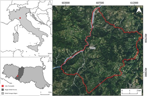
This research focuses on the landscape heritage of a portion of the Northern Apennines (Reggio Emilia province, Italy) (). The vast majority of the area has a warm temperate climate without a dry season but with warm summers (Köppen-Geiger Climate Classification: Cf, sub-continental/continental temperate) (CitationFratianni & Acquaotta, Citation2017; CitationKottek et al., Citation2006). The lithological composition is mainly sedimentary rocks with high clay components (i.e. sandstone and marl) (CitationHaller & Bender, Citation2018), and geomorphological slope processes are particularly prevalent (CitationMariani et al., Citation2019; CitationMontrasio et al., Citation2012). Soils in the area are scarce to moderately developed, moderately alkaline, deep and fertile; they are nevertheless prone to erosion, particularly those developed from silty-clayey flysch formations (CitationBini, Citation2013).
Figure 1. Location of Vetto on the Northern Apennines (Reggio Emilia province, Italy).
Human occupation has been well-documented since the mid-Holocene (CitationCremaschi et al., Citation2018; CitationTirabassi, Citation1979), but a profound reorganisation of the rural environment appears to have taken place in the Early Middle Ages (seventh–twelth centuries CE) (CitationRombai & Bomcompagni, Citation2010; CitationSereni, Citation1961). The area was affected by social changes resulting from the establishment of one of the most important pilgrimage routes in medieval Europe (the Via Francigena) (CitationScurani, Citation1895) and the foundation of fortresses in strategic positions (CitationMariani et al., Citation2019). These processes influenced the development of settlements and land management systems that continued into the mid-twentieth century CE. Since the 1950s, the decline of agrarian activities in the area has resulted in land-use change, which was often related to the abandonment of farmland and a progressive depopulation of the mountains (CitationHaller & Bender, Citation2018). In 2020, regional policies were implemented to provide economic incentives for repopulation in the region (Emilia Romagna, Citation2020).
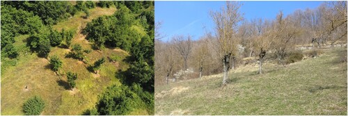
Vetto d'Enza (commonly referred as Vetto) is a small town located on the right bank of the Enza River in the Man and the Biosphere (MAB) Unesco reserve of the Tuscan – Emilian Apennines. The Region of Interest (ROI) coincides with the Vetto municipality (53.37 km2), including several hamlets dispersed across the territory. Among the most distinctive characteristics of the cultural landscape are well-preserved systems of agricultural terraces, usually built on the south- and west-facing slopes and faced with large blocks of local sandstone (Main Map, and ). Their date of origin is uncertain. According to historical documents, the establishment of agricultural terrace systems in the northern Apennines started during the Renaissance (fourteenth – fifteenth century CE) (CitationSereni, Citation1961). Nevertheless, recent analogous case studies have pushed the construction of large-scale terrace systems back to the tenth–twelth centuries CE (CitationTurner et al., Citation2021). In the study area, stone walls which are very similar to the terrace walls, have also been used widely between steeply-sloping fields, presumably to control soil erosion and delimit tenurial boundaries. Indeed, the historic rural landscape of the area is still characterised mainly by a mosaic of irregular fields often delimited by hedgerows with trees and shrubs. The genesis of this historic landscape is likely to date back to the thirteenth-century CE, when the sharecropping system was largely adopted in the region (CitationPiccinni, Citation2010; CitationRombaldi, Citation1965) along with agroforestry practices (known as ‘alberata emiliana’) (CitationMontanari, Citation2010; CitationSereni, Citation1961) (). The area’s land management system appears to have remained largely unaltered until the end of the nineteenth-century CE (CitationCafasi, 1980; CitationCazzola, Citation2010; CitationRombai & Bomcompagni, Citation2010).
Figure 2. Remnants of historical agroforestry systems that are still recognisable in the Vetto area. Regular rows of service trees were used to be cultivated with vineyards and crops (Photo: Ⓒ Brandolini F. 2021).
3. Material and methods
Geographic Information Systems (GIS) and remote sensing technologies are increasingly recognised as effective tools in landscape studies across different disciplines (CitationOtto et al., Citation2018; CitationPopescu & Gibbs, Citation2010; CitationWheatley & Gillings, Citation2013). The development of FOSS (Free and Open Source Software) geospatial tools has further broadened the community of users (CitationBrandolini et al., Citation2021; CitationSteiniger & Hay, Citation2009).
Each HLC study uses GIS (CitationDabaut & Carrer, Citation2020) to map ‘historic landscape character types’ (HLC types) based on distinctive characteristics, which result from known historical processes. HLC uses a qualitative but formalised method to map the chronological and spatial complexity of historic landscapes (CitationTurner, 2018; CitationTurner & Crow, Citation2010).
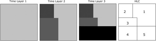
The HLC mapping of an area consists in the identification of the smallest ‘Uniform Diachronic Unit’ (UDU) with distinct landscape character through time. In this project, the specific threshold chosen corresponds to an area of 0.5 ha (=5000 m2). Each UDU consists of a polygon, whose size and shape depend on the variability of the HLC type throughout time. Initially, the spatial data sources were organised in Time Layers (TLs) according to their chronological phase. By comparing data from the oldest through to the most recent TLs, the smallest UDUs above the threshold of 0.5 ha were defined (CitationDabaut & Carrer, Citation2020) ().
Figure 3. Schematic representation of the ‘uniform diachronic unit’ principle used for Historic Landscape Characterisation (modified from CitationDabaut & Carrer, Citation2020).
In this research, the various sources employed include historical maps, nineteenth-century cadastral records, aerial photography and satellite images (for details, see ).
Table 1. Details of the sources employed for the HLC mapping in the study area.
Two sets of historic orthoimages (i.e. the Volo GAI and Volo CGRA, ) were provided in photogrammetric TIFF format (2500 dpi), while the sheets of the nineteenth-century cadastral map (i.e. Nuovo Catasto Terreni, ) were digitised using a photogrammetric approach (CitationBrandolini & Patrucco, Citation2019) with the software Agisoft Metashape (CitationAgisoft, Citation2020). All the sources not available in Web Map Service (WMS) format were georectified in QGIS 3.16.5-Hannover (CitationQGIS Development Team, Citation2021) with Thin Plate Spline (TPS) and cubic resampling methods (CitationBaiocchi et al., Citation2013; CitationBrandolini et al., Citation2020), using Ground Control Points (GCPs) identified in WMS cartographic sources (e.g. the topographic map called ‘Carta Tecnica Regionale’, ). Moreover, to minimise the spatial inaccuracy, the ‘backdating approach’ was employed (CitationBednarczyk et al., Citation2016), which consists of verifying and correcting the positions of the points in older maps according to recent and more accurate maps (CitationBrandolini et al., Citation2020; CitationLieskovský et al., Citation2018). The resulting HLC Spatio-temporal database consists of a GeoPackage (.gpkg) vectorial layer, in which all the information regarding the UDUs identified in the study area is stored and sorted in an attribute table. These values concern not only the physical characteristics of the UDUs (e.g. Land Use, Number of Fields, Pattern Morphology) but also a qualitative assessment of the accuracy of the data recorded (i.e. Confidence: Certain, Possible, Probable) and its legibility (i.e. Complete, Significant, Partial, Fragmentary, Invisible).
In the second stage of the project, this dataset was explored with two spatial statistical tools using the programming language R (CitationR Core Team, 2021): Local Indicators for Categorical Data (LICD) (CitationBivand et al., Citation2017; CitationBoots, Citation2006) and Point Pattern analysis (PPA) (CitationBaddeley et al., Citation2015). The LICD method is based on join-count statistics (JCS), measuring the correlation between binomial variables and the distance between observations (CitationCliff & Ord, Citation1973). LICD has been recently used in landscape archaeological studies for verifying visible patterns and disclosing hidden spatial relationships. It uses JCS to verify the occurrence of events (categories) in each spatial unit within the study area classifying the cells in the event (B) and non-event (W) regions. The resulting regional combinations are clumps (groups of B cells sharing an edge); cluster (significant number of Bs and significant BB); outlier (significant number of non-B); dispersed (significant BW); outlier in the heterogeneous area (significant outlier with significant BW) (CitationCarrer et al., Citation2021). In this research, LICD was used to address the local spatial associations between the UDUs.
PPA is the statistical study of point patterns to identify spatial trends in their density (CitationBaddeley et al., Citation2015). The application of PPA in landscape studies has been widely applied in Ecology (CitationBen-Said, Citation2021), and it is growing popular also in Archaeology (CitationBrandolini & Carrer, Citation2020; CitationCostanzo et al., Citation2021; CitationKnitter & Nakoinz, Citation2018). In this study, PPA was used to provide a quantitative assessment of the correlations between different components of the Vetto landscape. Three spatial variables were defined: the euclidean distances from irregular fields and combined fields, respectively and geomorphon (CitationJasiewicz & Stepinski, Citation2013). The latter was selected as a ‘control-covariate’ to check whether the topography of the area conditioned the position of historic settlements and abandoned rural buildings. Schwarz’s Bayesian Information Criterion (BIC) was employed to compare the competing models (Model 0 and Model 1) and assess the performance of each covariate (CitationZimmerman, Citation2010). Following the principle of parsimony, stepwise selection of covariates enables the identification of the combination of variables that minimises BIC values, and the covariates that show no significant correlation with the points are excluded during the process. BIC and stepwise model selection can be performed with the R package MASS function stepAIC (Akaike Information Criterion) (CitationVenables & Ripley, Citation2002). The significance of BIC-selected covariates was validated against the stationary model (Model 0), using BIC weights.
4. Results
The first stage consisted of the definition of HLC Types based on the information retrieved in the sources listed in at a grade that permits the definition of a sufficiently large range of types to avoid losing useful distinctions. In this study, the UDUs were classified into 7 classes and 16 types ().
Table 2. HLC Types defined in the research area.
According to the sources available, four main TLs were defined for the HLC mapping: 2010s, 2000s, 1970s and 1950s. The nineteenth-century regional cadastral map () matches largely with the 1950s fields, whose pattern might be dated back to the Late Medieval period (thirteenth–fifteenth century CE). Nevertheless, in the absence of certain chronology, this periodisation has been omitted in the pie charts () but has been recorded in the map in a generic ante-quem category (i.e.‘<1950s’ in the Main Map).
Figure 4. Pie charts representing the occurrence of HLC Types in the four different periods: 1950s, 1970s, 2000s, 2010s.
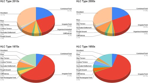
By comparing the occurrence of HLC types diachronically over the last 70 years (), it is immediately apparent that there has been a significant change, which includes the loss of many of the traditional irregular fields (i.e. small rural parcels with irregular boundaries). The disappearance of irregular fields largely coincides with the progressive increase of combined fields (i.e. open areas which have been created by the amalgamation of earlier patterns of fields whose boundaries are still recognisable partially) or abandoned areas (e.g. woodland) (). This significant landscape change is probably linked to the economic transformations and depopulation processes that have affected these mountainous areas since the 1950s (CitationHaller & Bender, Citation2018).
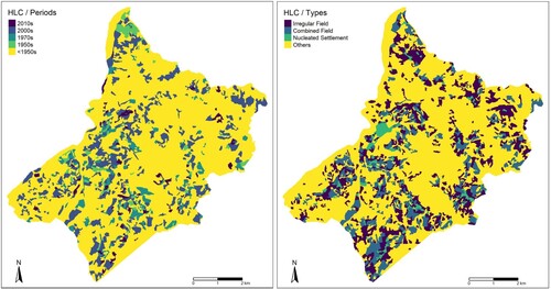
The occurrence of subtler patterns of landscape transformation was addressed by examining the distributions of UDUs according to their chronology (Main Map – LICD/HLC Periods) and according to the HLC types (Main Map – LICD/HLC Types) that occur most frequently in the ROI: irregular fields, combined fields and nucleated settlements ().
Figure 5. HLC maps representing the UDUs according to their chronology (on the left) and the most common HLC type in the current landscape (on the right).
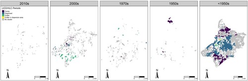
In detail, the LICD analysis applied to the HLC chronology shows no significant spatial association in landscape components related to the 2010s. In the 2000s, landscape patterns might be due to the urban development of Vetto (Main Map, ) and the establishment of dispersed combined fields in the southern portion of the ROI. In the 1950s, a clumped area was detected in the northwest part of the ROI. Finally, the historic landscape mostly belongs to the pre-contemporary period (<1950s), and the LICD analysis shows two large clumped zones in the north and south. These two areas seem to be the best-preserved parts of the historic landscape, which is probably attributable to post-medieval land management strategies ().
Figure 6. Results of the LICD analysis applied to the HLC chronology.
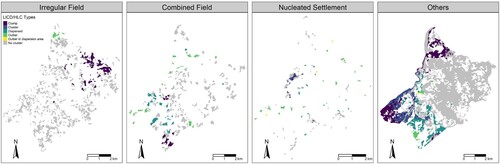
Considering the most common HLC types (Main Map – LICD/HLC Types), irregular fields show a clear spatial association, especially in the northern area of the ROI, while the combined fields are mildly correlated to the south of Vetto. These LICD results could mean that the irregular fields, historically related to post-medieval sharecropping, are better preserved in the northeast sector of the ROI. On the contrary, irregular fields tend to have been replaced by combined fields moving to the south of Vetto and this might correspond to a general abandonment of small agricultural properties, especially in remote areas at higher altitudes. Nucleated settlements show clustering only in correspondence to Vetto due to the progressive urbanisation that has occurred here since the 1950s ().
Figure 7. Results of the LICD analysis applied to the HLC types.
There appear to be spatial relationships between some HLC types and different components of the settlement pattern, for example, between irregular fields and historical settlements (first recorded on maps from the nineteenth-century CE), and between combined fields and abandoned rural buildings (i.e. structures identified from cartography and satellite imagery but now abandoned) (see Main Map). PPA was employed to assess spatial dependencies, and Model 1 scored the best performance against the stationary model (Model 0) in both cases. In other words, PPA shows a clear spatial correlation between historic settlements and irregular fields () and abandoned rural buildings and combined fields (), respectively.
Table 3. Results of PPA with the historic settlement point pattern.
Table 4. Results of PPA with the abandoned rural buildings point pattern.
5. Discussion and conclusions
In the resulting Main Map, pre-twentieth-century (<1950s) landscape components can be easily distinguished from those which show substantial later change after the 1950s. Farmland and residential zones, in particular, reflect a mixture of types and historical processes relating to the last ≈ 70 years of landscape change. This should be especially relevant for development planning since it may help identify areas likely to be particularly sensitive to future change.
The application of LICD highlights localised processes of landscape development, revealing interesting and previously unrecognised spatial patterns. In detail, modern and contemporary HLC types are largely isolated among character types of older chronology and present no particular spatial association (). On the contrary, pre-1950s types (i.e. irregular fields) are more spatially interwoven than expected, and the local landscape character is not strongly affected by the change occurring in neighbouring regions (). In detail, pre-twentieth-century irregular fields are predominant around historic settlements (), while the advent of combined fields seems correlated to the presence of abandoned rural buildings (). PPA confirmed this spatial association between different landscape components. Even if correlation does not necessarily mean causation (CitationBaddeley et al., Citation2015), such unpredicted spatial relations between landscape change and historical character can have important implications for future landscape management and development. In this case, for example, historic settlements and their surrounding irregular fields need to be considered in future landscape management plans.
Software
The historical cadastral maps were digitised using the software Agisoft Metashape 1.7.5. Data processing and map design were performed with open-source GIS software QGIS 3.16.5 Hannover (Citation2021 QGIS Development Team). The LICD and PPA analysis were conducted with the programming language R (CitationR Core Team, 2021) in Rstudio (CitationRStudio Team, 2021). Spatial covariates have been developed in GRASS GIS (CitationGRASS Dev. Team, Citation2020).
Open Scholarship

This article has earned the Center for Open Science badge for Open Data. The data are openly accessible at https://doi.org/10.5281/zenodo.5907229.
TJOM_2088305_Supplemental materials
Download PDF (38.2 MB)Acknowledgements
The authors would like to acknowledge the help of the mayor Mr Fabio Ruffini and all the staff of Vetto d’ Enza, Dr. Alessandra Curotti and Dr. Chiara Cantini and (Unione Montana dei Comuni dell’Appennino Reggiano) and Dott.ssa Annalisa Capurso (Soprintendenza Archeologia Belle Arti e Paesaggio per la città metropolitana di Bologna e le province di Modena, Reggio Emilia e Ferrara) for their administrative assistance in the preparation of the project fieldwork activities. Also, they thank Dr Anna Campeol and Mr Davide Cavecchi (Provincia di Reggio Emilia - Ufficio Topografico) for their help in retrieving and digitising the Nuovo Catasto Terreni cadastral map. The authors also thank the AsRe (Archivio Stato di Reggio Emilia) and AsPr (Archivio Stato di Parma) administration and staff for giving the right to digitise the historical maps and for helping during the consultation at the archives. Finally, we thank Francesco Carrer (Newcastle University, Newcastle upon Tyne, UK) for his comments on the R script code, and Christopher Sevara (Newcastle University, Newcastle upon Tyne, UK) for his suggestions for retrieving historical satellite images. The authors are also thankful to the three reviewers of this paper for their valuable suggestions.
Disclosure statement
No potential conflict of interest was reported by the author(s).
Data availability statement
The R script Code, HLC dataset and PPA spatial covariates are available on Zenodo: https://doi.org/10.5281/zenodo.5907229. For a detailed description of LICD, please refer to CitationCarrer et al. (Citation2021) while for an exhaustive explanation of the use of PPA in landscape archaeology, consider the paper of CitationKnitter and Nakoinz (Citation2018).
Additional information
Funding
References
- AGEA. (2008). https://geoportale.regione.emilia-romagna.it/catalogo/dati-cartografici/cartografia-di-base/immagini/layer-3
- AGEA. (2011). https://geoportale.regione.emilia-romagna.it/catalogo/dati-cartografici/cartografia-di-base/immagini/layer-2
- Agisoft. (2020). Agisoft metashape (version 1.6). https://www.agisoft.com/pdf/metashape-pro_1_6_en.pdf
- Arnaez, J., Lasanta, T., Errea, M. P., & Ortigosa, L. (2011). Land abandonment, landscape evolution, and soil erosion in a Spanish Mediterranean mountain region: The case of Camero Viejo. Land Degradation & Development, 22(6), 537–550. https://doi.org/10.1002/ldr.1032
- Baddeley, A., Rubak, E., & Turner, R. (2015). Spatial point patterns: Methodology and applications with R. CRC Press.
- Baessler, C., & Klotz, S. (2006). Effects of changes in agricultural land-use on landscape structure and arable weed vegetation over the last 50 years. Agriculture, Ecosystems & Environment, 115(1), 43–50. https://doi.org/10.1016/j.agee.2005.12.007
- Baiocchi, V., Lelo, K., Milone, M. V., & Mormile, M. (2013). Accuracy of different georeferencing strategies on historical maps of Rome. Geographia Technica, 1, 10–16. https://technicalgeography.org/pdf/1_2013/02_1_2013.pdf
- Bednarczyk, B., Kaim, D., & Ostafin, K. (2016). Forest cover change or misinterpretation? On dependent and independent vectorisation approaches. Prace Geograficzne (146), 19–30. https://doi.org/10.4467/20833113PG.16.015.5545
- Ben-Said, M. (2021). Spatial point-pattern analysis as a powerful tool in identifying pattern-process relationships in plant ecology: An updated review. Ecological Processes, 10(1), 1–23. https://doi.org/10.1186/s13717-021-00314-4
- Bini, C. (2013). Geology and geomorphology. In E. A. C. Costantini & C. Dazzi (Eds.), The soils of Italy (pp. 39–56). Springer.
- Bivand, R. S., Wilk, J., & Kossowski, T. (2017). Spatial association of population pyramids across Europe: The application of symbolic data, cluster analysis and join-count tests. Spatial Statistics, 21(August), 339–361. https://doi.org/10.1016/j.spasta.2017.03.003
- Boots, B. (2006). Local configuration measures for categorical spatial data: Binary regular lattices. Journal of Geographical Systems, 8(1), 1–24. https://doi.org/10.1007/s10109-005-0010-9
- Brandolini, F., & Carrer, F. (2020). Terra, Silva et Paludes. Assessing the role of alluvial geomorphology for late-holocene settlement strategies (Po Plain – N Italy) through point pattern analysis. Environmental Archaeology, March, 1–15. https://doi.org/10.1080/14614103.2020.1740866
- Brandolini, F., Domingo-Ribas, G., Zerboni, A., & Turner, S. (2021). A google earth engine-enabled python approach to improve identification of anthropogenic palaeo-landscape features. Open Research Europe, https://doi.org/10.12688/openreseurope.13135.1
- Brandolini, F., & Patrucco, G. (2019). Structure-from-Motion (SFM) photogrammetry as a non-invasive methodology to digitalize historical documents: A highly flexible and low-cost approach? Heritage Review, 2(3), 2124–2136. https://doi.org/10.3390/heritage2030128
- Brandolini, F., Reynard, E., & Pelfini, M. (2020). Multi-temporal mapping of the Upper Rhone Valley (Valais, Switzerland): Fluvial landscape changes at the end of the Little Ice Age (18th–19th centuries). Journal of Maps, 16(2), 212–221. https://doi.org/10.1080/17445647.2020.1724837
- Cafasi, F. (1980). L’agricoltura Negli Stati Estensi Nel Periodo Pre-Unitario. Rivista Di Storia dell’Agricoltura, XX(2), 79–94.
- Carrer, F., Kossowski, T. M., Wilk, J., Pietrzak, M. B., & Bivand, R. S. (2021). The application of local indicators for categorical data (LICD) to explore spatial dependence in archaeological spaces. Journal of Archaeological Science, 126(February), 105306. https://doi.org/10.1016/j.jas.2020.105306
- Carta Storica Regionale. (1853). https://geoportale.regione.emilia-romagna.it/catalogo/dati-cartografici/cartografia-di-base/cartografia-storica/layer-1
- Cazzola, F. (2010). Colture, lavori, tecniche, rendimenti. In G. Pinto, C. Poni, & U. Tucci, II (Eds.), Storia dell’agricoltura italiana - IL MEDIOEVO E L'ETÀ MODERNA (pp. 223–254). Polistampa.
- CGR. (2018). https://geoportale.regione.emilia-romagna.it/catalogo/dati-cartografici/cartografia-di-base/immagini/layer-4
- CGRA. (1976). Provincia Di Reggio Emilia. 1976. https://www.provincia.re.it/aree-tematiche/pianificazione-territoriale/sistema-informativo-territoriale/archivio-cartografico/foto-aeree/volo-cgra-1976-78-scala-113-500/
- Cliff, A. D., & Ord, J. K. (1973). Spatial autocorrelation. Pion.
- Costanzo, S., Brandolini, F., Ahmed, H., Zerboni, A., & Manzo, A. (2021). Creating the funerary landscape in Eastern Sudan. PlosOne, https://doi.org/10.1371/journal.pone.0253511
- Cremaschi, M., Mercuri, A. M., Benatti, A., Bosi, G., & Brandolini, F. (2018). The SUCCESSO-TERRA project: A lesson of sustainability from the terramare culture, middle bronze age of the Po Plain (Northern Italy). Interdisciplinaria Archaeologica Natural Sciences in Archaeology, IX(2). http://www.iansa.eu/papers/IANSA-2018-02-the-successo-terra-project-a-lesson-of-sustainability_onlinefirst.pdf
- CTR. (2018). Carta Tecnica Regionale. 2018. https://geoportale.regione.emilia-romagna.it/catalogo/dati-cartografici/cartografia-di-base/cartografia-tecnica/layer-1
- Dabaut, N., & Carrer, F. (2020). Historic landscape characterisation: Technical approaches beyond theory. Landscapes, 21(2), 152–167. https://doi.org/10.1080/14662035.2020.1993562
- Di Fazio, S., & Modica, G. (2018). Historic rural landscapes: Sustainable planning strategies and action criteria. The Italian experience in the global and European context. Sustainability: Science Practice and Policy, 10(11), 3834. https://doi.org/10.3390/su10113834
- Emilia Romagna. (2020). Bando Montagna 2020. https://montagna.regione.emilia-romagna.it/leggi-atti-bandi/bandi/bando-montagna-2020/bando-montagna-1
- EU Commission. (2020). Rural Development Program 2014-2020. https://agriculture.ec.europa.eu/common-agricultural-policy/rural-development_en
- Fàbregas, J. B., & Ramos, A. (2017). Chapter 2. Management of the territory: Landscape management as a process. In Landscape dimensions: Reflections and proposals for the implementation of the European landscape convention, 25–54. Council of Europe.
- Fisher, C. (2020). Archaeology for sustainable agriculture. Journal of Archaeological Research, 28(3), 393–441. https://doi.org/10.1007/s10814-019-09138-5
- Fratianni, S., & Acquaotta, F. (2017). The climate of Italy. In M. Soldati & M. Marchetti (Eds.), Landscapes and landforms of Italy (pp. 29–38). Springer International Publishing.
- Fredholm, S., Eliasson, I., & Knez, I. (2018). Conservation of historical landscapes: What signifies ‘successful’ management? Landscape Research, 43(5), 735–748. https://doi.org/10.1080/01426397.2017.1335864
- GRASS Dev. Team. (2020). Geographic resources analysis support system (GRASS) (Version 7.2.). Open Source Geospatial Foundation. http://grass.osgeo.org
- Haller, A., & Bender, O. (2018). Among rewilding mountains: Grassland conservation and abandoned settlements in the Northern Apennines. Landscape Research, 43(8), 1068–1084. https://doi.org/10.1080/01426397.2018.1495183
- Harvey, D. (2015). Landscape and heritage: Trajectories and consequences. Landscape Research, 40(8), 911–924. https://doi.org/10.1080/01426397.2014.967668
- Herring, P. C. (2009). Framing perceptions of the historic landscape: Historic landscape characterisation (HLC) and historic land-use assessment (HLA). Scottish Geographical Journal, 125(1), 61–77. https://doi.org/10.1080/14702540902873907
- IGM. (1954). Istituto Geografico Militare. 1954. https://www.igmi.org/
- Jasiewicz, J., & Stepinski, T. F. (2013). Geomorphons—a pattern recognition approach to classification and mapping of landforms. Geomorphology, 182, 147–156. https://doi.org/10.1016/j.geomorph.2012.11.005
- Kalman, H., & Létourneau, M. R. (2020). Heritage planning: Principles and process. Routledge.
- Karcagi Kováts A., & Katona Kovács J. (2012). Factors of population decline in rural areas and answers given in EU member states’ strategies. Food Research Institute Studies in Agricultural Economics, Trade, and Development, 114(1), 49–56.
- Knitter, D., & Nakoinz, O. (2018). Point pattern analysis as tool for digital geoarchaeology: A case study of Megalithic Graves in Schleswig-Holstein, Germany. In C. Siart, M. Forbriger, & O. Bubenzer (Eds.), Digital geoarchaeology: New techniques for interdisciplinary human-environmental research (pp. 45–64). Springer International Publishing.
- Kottek, M., Grieser, J., Beck, C., Rudolf, B., & Rubel, F. (2006). World map of the Köppen-Geiger climate classification updated. Meteorologische Zeitschrift, 15(3), 259–263. https://doi.org/10.1127/0941-2948/2006/0130
- Lieskovský, J., Kaim, D., Balázs, P., Boltižiar, M., Chmiel, M., Grabska, E., Király, G., Konkoly-Gyuró, E., Kozak, J., Antalová, K., Kuchma, T., Mackovčin, P., Mojses, M., Munteanu, C., Ostafin, K., Ostapowicz, K., Shandra, O., Stych, P., & Radeloff, V. C. (2018). Historical land use dataset of the carpathian region (1819–1980). Journal of Maps, 14(2), 644–651. https://doi.org/10.1080/17445647.2018.1502099
- Malandra, F., Vitali, A., Urbinati, C., & Garbarino, M. (2018). 70 years of land use/land cover changes in the Apennines (Italy): A meta-analysis. Forests, Trees and Livelihoods, 9(9), 551. https://doi.org/10.3390/f9090551
- Mariani, G. S., Brandolini, F., Pelfini, M., & Zerboni, A. (2019). Matilda’s Castles, Northern Apennines: Geological and geomorphological constrains. Journal of Maps, 15(2), 521–529. https://doi.org/10.1080/17445647.2019.1625823
- Mitchell, N., Rössler, M., & Tricaud, P.-M. (2009). World heritage cultural landscapes: A handbook for conservation and management. UNESCO World Heritage Centre.
- Modica, G., Praticò, S., & Di Fazio, S. (2017). Abandonment of traditional terraced landscape: A change detection approach (a case study in Costa Viola, Calabria, Italy). Land Degradation & Development, 28(8), 2608–2622. https://doi.org/10.1002/ldr.2824
- Montanari, M. (2010). Colture, lavori, tecniche, rendimenti. In G. Pinto, C. Poni, & U. Tucci, II (Eds.), Storia dell’agricoltura italiana - IL MEDIOEVO E L'ETÀ MODERNA (pp. 59–82). Polistampa.
- Montrasio, L., Valentino, R., & Losi, G. L. (2012). Shallow landslides triggered by rainfalls: Modeling of some case histories in the Reggiano Apennine (Emilia Romagna Region, Northern Italy). Natural Hazards, 60(3), 1231–1254. https://doi.org/10.1007/s11069-011-9906-5
- NextGis. (2019). QuickMapServices (version 0.19.11). https://github.com/nextgis/quickmapservices
- Nuovo Catasto Terreni. (1900). https://www.provincia.re.it/aree-tematiche/pianificazione-territoriale/sistema-informativo-territoriale/archivio-cartografico/cartografia-storica/carta-catastale-di-impianto-della-provincia-di-reggio-emilia-scala-12-000-11-000-edizione-fine-xix-secolo/
- Ostafin, K., Pietrzak, M., & Kaim, D. (2021). Impact of the Cartographer’s position and topographic accessibility on the accuracy of historical land use information: Case of the second military survey maps of the Habsburg empire. ISPRS International Journal of Geo-Information, 10(12), 820. https://doi.org/10.3390/ijgi10120820
- Otto, J.-C., Prasicek, G., Blöthe, J., & Schrott, L. (2018). 2.05 – GIS applications in geomorphology. In B. Huang (Ed.), Comprehensive geographic information systems (pp. 81–111). Elsevier.
- Piccinni, G. (2010). La proprietà della terra, i percettori dei prodotti e della rendita. In G. Pinto, C. Poni, & U. Tucci, II (Eds.), Storia dell’agricoltura italiana - IL MEDIOEVO E L'ETÀ MODERNA (pp. 145–170). Polistampa.
- Popescu, V. D., & Gibbs, J. P. (2010). Landscape ecology and GIS methods. In C. Kenneth Dodd Jr (Ed.), Amphibian ecology and conservation: A handbook of techniques, 339–356). OUP Oxford.
- QGIS Development Team. (2021). QGIS geographic information system. Open Source Geospatial Foundation Project (version 3.16). https://www.qgis.org/en/site/index.html
- R Core Team. (2021). R: A language and environment for statistical computing. R Foundation for Statistical Computing. https://www.R-project.org/
- Rombai, L., & Bomcompagni, A. (2010). Popolazione, popolamento, sistemi colturali, spazi coltivati, aree boschive ed incolte. In G. Pinto, C. Poni, & U. Tucci, II (Eds.), Storia dell’agricoltura italiana - IL MEDIOEVO E L'ETÀ MODERNA (pp. 171–222). Polistampa.
- Rombaldi, O. (1965). Dalla Mezzadria Nel Reggiano, a Proposito Del Saggio Sopra La Storia dell’Agricoltura Di Filippo Re. Rivista Di Storia dell’Agricoltura, V(1), 22–48.
- Scurani, P. (1895). Le Chiese Della Diocesi Reggiana. Curia Vescovile di Reggio E.
- Sereni, E. (1961). Storia Del Paesaggio Agrario Italiano.
- Steiniger, S., & Hay, G. J. (2009). Free and open source geographic information tools for landscape ecology. Ecological Informatics, 4(4), 183–195. https://doi.org/10.1016/j.ecoinf.2009.07.004
- Stephens, L., Fuller, D., Boivin, N., Rick, T., Gauthier, N., Kay, A., Marwick, B., Armstrong, C. G., Barton, C. M., Denham, T., Douglass, K., Driver, J., Janz, L., Roberts, P., Rogers, J. D., Thakar, H., Altaweel, M., Johnson, A. L., Vattuone, M. M. S., … Ellis, E. (2019). Archaeological assessment reveals earth’s early transformation through land use. Science, 365(6456), 897–902. https://doi.org/10.1126/science.aax1192
- Timár, G., Molnár, G., Székely, B., Biszak, S., Varga, J., & Jankó, A. (2006). Digitized maps of the Habsburg empire – the map sheets of the second military survey and their georeferenced version. Arcanum.
- Tirabassi, J. (1979). I Siti Dell’età Del Bronzo. Municipio di Reggio Emilia, Civici Musei.
- Turner, S. (2006). Historic landscape characterisation: A landscape archaeology for research, management and planning. Landscape Research, 31(4), 385–398. https://doi.org/10.1080/01426390601004376
- Turner, S. (2018). Historic landscape characterisation: An archaeological approach to landscape heritage. In Routledge handbook of landscape character assessment, 37–50. Routledge.
- Turner, S., & Crow, J. (2010). Unlocking historic landscapes in the Eastern Mediterranean: Two pilot studies using historic landscape characterisation. Antiquity, 84(323), 216–229. https://doi.org/10.1017/S0003598X00099889
- Turner, S., Kinnaird, T., Koparal, E., Lekakis, S., & Sevara, C. (2020). Landscape archaeology, sustainability and the necessity of change. World Archaeology, 52(4), 589–606. https://doi.org/10.1080/00438243.2021.1932565
- Turner, S., Kinnaird, T., Varinlioğlu, G., Şerifoğlu, T. E., Koparal, E., Demirciler, V., Athanasoulis, D., Ødegård, K., Crow, J., Jackson, M., Bolòs, J., Sánchez-Pardo, J. C., Carrer, F., Sanderson, D., & Turner, A. (2021). Agricultural terraces in the Mediterranean: Medieval intensification revealed by OSL profiling and dating. Antiquity, 95(381), 773–790. https://doi.org/10.15184/aqy.2020.187
- USGS EROS Archive – Declassified Data – Declassified Satellite Imagery – 3. (n.d). Retrieved December 13, 2021, from https://www.usgs.gov/centers/eros/science/usgs-eros-archive-declassified-data-declassified-satellite-imagery-3
- Venables, W. N., & Ripley, B. D. (2002). Modern applied statistics with S. Statistics and Computing, https://doi.org/10.1007/978-0-387-21706-2
- Wheatley, D., & Gillings, M. (2013). Spatial technology and archaeology: The archaeological applications of GIS. CRC Press.
- Zimmerman, D. (2010). Likelihood-based methods. In Handbooks of modern statistical methods. Chapman & Hall/CRC. https://doi.org/10.1201/9781420072884-c4