
ABSTRACT
Analysis of prehistoric lithic artefacts helps to answer a wide array of questions concerning archaeological contexts and prehistoric human behaviour. During three projects, we studied the origin of the raw materials of 32 inventories from the Late Glacial and Early Holocene in northwest and southern Germany. The basal petrographic analysis was conducted by the geologist and petro-archaeologist Jehanne Affolter. In addition, data of more than 60 published assemblages from Switzerland as well as western and southern Germany were recorded. The origin of lithic raw materials from most of these inventories was determined using the microfacial method. GIS-based maps of the raw material sources from the aforementioned regions are compiled and raw material catchment areas of the Stone Age sites are mapped. The area calculations of the raw material catchments revealed a diachronic alternation of larger and smaller areas, which above all suggest culturally determined cycles in the range of mobility and communication networks.
1. Introduction
Stone artefacts are one of the main sources for studying Stone Age societies (Palaeolithic to Neolithic). Their analysis contributes to a deeper understanding of past human behaviour including cognitive aspects, technological aspects or raw material procurement strategies. The latter are a.o. a crucial basis for developing concepts of mobility and communication networks. They will be the focus of this paper. Case studies from the Final Palaeolithic, Mesolithic and Neolithic of Central Europe form the basis for a diachronic perspective on raw material catchments that allow for a comparison of foragers and early farmer, i.e. mobile and sedentary societies.
A fundamental precondition for the production of lithic artefacts was the availability of suitable raw material. Depending on the geological and geomorphological situation, the raw material sources used provide information about the knowledge of the environment, the direction and distances of movement and the social networks of the inhabitants of a specific site.
Therefore, determining the origin of lithic raw materials in Stone Age inventories gives us clues as to where people moved or to which regions their social contacts extended. For this purpose, it is important to carry out the identification of origin as precisely as possible.
1.1. Background
For decades, in archaeological research the origin of lithic raw material was determined macroscopically. In the 1990s, the micro-facial analysis was introduced, but initially only used by a few scientists in France and Switzerland (CitationAffolter, 2002, Citation2011; CitationBressy-Léandri, 2002; CitationFernandes et al., 2013). During the last 20 years, this method has become more established and is now recognised by many archaeologists as one of the most promising approaches (see CitationScharl et al., 2021). It allows for a relatively precise indication of the age of the geological deposits from which the siliceous material originates and of the environment in which the raw material was formed. This is based on the identification of microfossils and other components, such as charcoal, organic or mineral inclusions enclosed in the siliceous material. Based on this the geological age, the depositional age, and the depositional environment can be identified. These features provide direct clues to the possible region in which the corresponding geological strata are located. Direct comparisons with geological samples are used to confirm or to disconfirm the result. Furthermore, one can consider the type of deposition of the rocks – primary or secondary – by taking a closer look at the natural surfaces preserved on the artefacts (CitationAffolter, 2002, Citation2011, Citation2018).
Within the framework of two university projects, numerous find complexes from Stone Age sites in western and south-western Germany were examined by J. Affolter using the micro-facial approach. In this paper, these results are combined with previously published data from Switzerland, southern Germany and south-eastern France. Additionally, the results of some important but exclusively macroscopically determined inventories are taken into account in order to complete the chronological sequence in some regions.
1.2. Purpose
The maps presented here show all lithic assemblages investigated for this paper as well as the identified raw material sources and the raw material catchment areas per site and find layer. The comparison of inventories from several geographical regions and different Stone Age periods aims at the identification of supra-regional and chronologically patterns. Additionally, the role of site location in connection with the potential availability of the raw material sources will be discussed with regard to the patterns identified. Likewise, the size of the raw material catchment areas can provide information about the degree of mobility of the group members as well as the range of their communication during social and/or economic contacts.
2. Methods
The data on the origin of the siliceous raw materials used for our maps mainly come from the investigations of J. Affolter, which she has conducted since the 1990s and which have already been published (see Appendix 1 with references). Most of them are lithic assemblages from Switzerland, but there are also some from south-eastern France and southern Germany. Within the framework of two research projects, further data on inventories from western Germany (Rhineland and Westphalia, CRC 806 University of Cologne) and from Bavaria (Prehistoric Archaeology, University of Erlangen-Nuremberg) have been recorded in recent years by Affolter. These investigations were carried out using the micro-facial method (for further details see CitationAffolter, 2011; Citation2018; CitationFernandes et al., 2013). Since the samples chosen for Affolter’s analysis were mostly selected by the archaeologists on the basis of macroscopic features, these data neither represent all available silicites of a region nor is it complete with regard to all Stone Age periods. Therefore, some macroscopically determined inventories were additionally included in this study, which are assumed to describe the actual catchment areas reasonably well.
In contrast to the complexes analysed by J. Affolter, the selected macroscopically determined assemblages have been recorded completely. Since the micro-facial investigation is labour-intensive and expensive and only a few specialists can carry it out, Affolter for her analysis was often provided with a selection of samples. Often, sample selection was therefore biased, as primarily typologically significant tools and macroscopically conspicuous raw materials were selected. The raw material proportions of Affolter’s investigations are therefore not statistically representative, but presumably indicate the entire raw material spectrum of the respective inventory. In terms of representativeness, one also has to consider, that the number of sites per time slice and the duration of time slices vary (for details see 2.1 and Appendix 1).
2.1. Sources of data
Most of the data comes from research carried out by J. Affolter for her doctoral thesis (CitationAffolter, 2002) and on behalf of the cantonal archaeologies of Switzerland as well as various projects in south-eastern France and Bavaria. These research results have all been published (see Appendix 1). In addition, data are presented that originate from research projects on the Rhineland and Westphalia, the Allgäu, and one Mesolithic site in Hesse, which are published together here for the first time. Next to this, published data on selected macroscopically determined raw material assemblages was added.
2.1.1. Sites/inventories
In relation to geochronology, the results of the raw material investigations presented here cover the period from the Late Glacial up to the mid-Holocene. Culturally, they cover the timespan from the Late Magdalenian to the Late Neolithic (; Appendix 1).
Figure 1. Simplified chronology of the Late/Final glacial and Early Holocene cultural development. Only phases and cultural groups evaluated in this paper are presented (graph B. Gehlen).
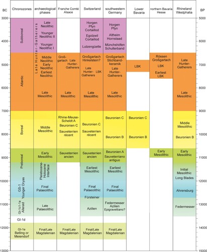
Neolithic find complexes were only chosen from regions for which comparisons between macroscopically determined and micro-facially examined artefact inventories were possible. Also, there are no assemblages from the Rhineland and Westphalia dating to the Meiendorf-Interstadial since reliable data on the raw material sources was not available. Therefore, no mapping of Late Magdalenian and Neolithic sites was done for western Germany, and only three sites from the Early Mesolithic and the earliest Linear Pottery culture (LBK) from Hesse could be regarded. The results show the great potential of this Middle mountain region which serves as an important connecting area between western and southern Germany.
In total, we evaluated data from 95 sites with 116 inventories. From the Palaeolithic, we present seven Late Magdalenian sites, four Azilian and four Federmesser sites, three Ahrensburgian sites and five inventories of the Younger Dryas. Five assemblages date to the Pleistocene-Holocene interface (Appendix 1; Map B). For the Mesolithic we present the results of nine Early Mesolithic assemblages dating to the Preboreal period. They come from four different cultural contexts. Most of our studied inventories (N = 23) belong to the Middle Mesolithic of the Boreal period. They belong to five different cultural taxonomic units. In total, 14 sites date to the Late Mesolithic representing three different cultural taxonomic units. Only eight assemblages can be attributed to the ‘Late Hunter-Gatherers’, who lived parallel or among the Early and Middle Neolithic people.
For the Neolithic, we count three sites of the earliest LBK and six for the later LBK. From the Middle Neolithic we present six sites with material of five different cultural groups. The Younger Neolithic is divided into two phases. Four sites date to the older phase I and nine to the later phase II together representing eight cultural taxonomic units. Finally, the Late Neolithic is represented with six sites from five cultural taxonomic contexts.
2.1.2. Raw material sources
Only the raw material sources from J. Affolter's investigations are listed in Appendix 2. They mainly represent directly localizable outcrops. The materials can come from both primary and secondary sources. Other raw materials come from secondary outcrops in moraines and river gravels as well as displaced materials. For our maps, the closest possible origin – related to the sites analysed – was assumed based on geological maps (cf. CitationGehlen et al., 2022; CitationSchön et al., 2020). This also applies to the raw materials mentioned in the literature, which were only determined macroscopically.
The areas under consideration are not only very different with regard to their general geomorphology and altitude, but also the type and frequency of raw material sources differ significantly. While Upper Cretaceous flints dominate in the northwest, Jurassic raw materials are most common in the south and southwest. Here the primary raw material sources are much more numerous than in the northwest. In both regions secondary raw material sources are relatively frequent due to many rivers and streams and the glacial character of the landscapes.
2.2. Analytic procedures
The GIS-mapping and analysis was conducted with the programme QGIS, ver. 3.10 ‘A Coruña’ (Nov. 2019). Affolter works with a very extensive reference collection of geological samples. In our mapping, the primary raw material sources are given the point coordinates of these sources of comparison. As already mentioned, raw materials from secondary deposits with a very large geographical distribution are mapped on the basis of the location of the geological formations from which they most probably originate. The closest possible point is determined as the source of the raw material and these coordinates are used for the mapping. Thus, these sources had to be recalculated for each site. After the mapping of lithic raw material sources and sites, the smallest encompassing polygon using the QGIS-analysis ‘convex hull’ was generated. The sizes of these polygons were calculated with the analysis ‘§area’ in the field calculator.
The graphical-statistical visualisation in was done in ‘R’ (CitationR Core Team, 2022). The data on which this analysis is based can be found in Appendix 1. Results of the statistical analyses are listed in Appendix 3.
Figure 2. Boxplots for the polygon sizes of the Palaeolithic sites and those from the Pleistocene-Holocene Interface. The differences in the areas of all Palaeolithic phases and the transition are not statistically significant (Kruskal–Wallis-test, p = 0.4409). The differences between the southern and the western working area, however, are significant (Kruskal–Wallis-test, p = 0.03096) (Graph Frank Siegmund).
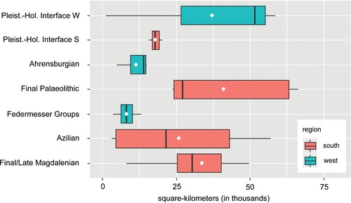
Figure 3. Boxplots for the polygon sizes of the Mesolithic sites. The differences are statistically significant (Kruskal–Wallis-Test, p = 0.00108) (Graph Frank Siegmund).
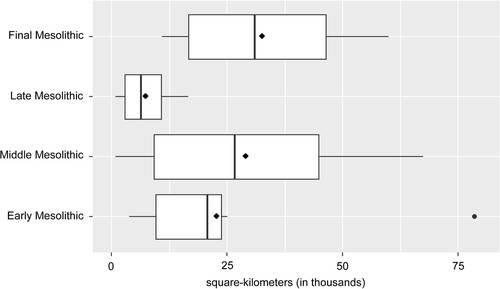
Figure 4. Boxplots for the polygon sizes of the Neolithic sites. The differences are statistically significant (Kruskal–Wallis-Test, p = 0.00427) (Graph Frank Siegmund).
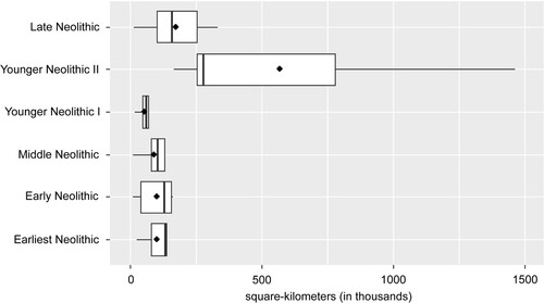
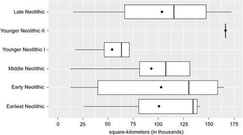
Figure 5. Boxplots for the polygon sizes of the Neolithic sites without the one for the Younger Neolithic II to illustrate the dimensions of the other phases more clearly (Graph Frank Siegmund).
Due to the small number of cases we were able to obtain for the individual groups and the partly high variability within the groups, some tests do not turn out to be significant. However, the figures reliably illustrate trends.
3. Results and conclusions
When assessing the nature and range of mobility and communication networks, several biasing factors have to be taken into account. A bias of the sample material for reasons of costs or time is present in almost all inventories studied. In addition, there are several other factors. First of all, the small number of micro-facially analysed find inventories in some regions or from some chronological phases should be mentioned. In a recently published study, it was shown that the raw material polygons of exclusively macroscopically investigated ensembles are significantly smaller than those of micro-facially investigated ones (CitationGehlen et al., 2022). If we assume that this is a general situation, the catchment areas presented here are probably too small for the Federmesser-Groups and the Early Mesolithic in the Rhineland and for most LBK and Middle Neolithic inventories in the south. Further problems arise from the different conditions under which the finds were collected. Surface collections with artefacts of different age are of lower quality than recently excavated find complexes because of the difficulties in addressing the sample material chronologically. Other factors concern the size, duration of occupation and function of the settlement sites. Even if one could gain clues here from the publications, it would probably not be possible to filter out enough material from the different phases to make statistically reliable statements for a general overview. Despite these imponderables, our analysis and the regional and diachronic comparison of the results show that certain patterns emerge.
3.1. Palaeolithic
We analysed four phases of the Late and Final Palaeolithic, which are dated to the Meiendorf-Interstadial (northern Central Europe) or Bølling-Interstadial (southern Central Europe) (GI-1e), the Allerød-Interstadial (GI-1c1-1a), the Younger Dryas (GS-1), and the Pleistocene-Holocene interface (T-1 until the PB-Oscillation). Map – B and show evident differences between the two main research areas.
While the Late Magdalenian could only be investigated in the southern area, sites from the other periods are present in both. We recognise opposite developments in the two regions (). The raw material catchments for the Late Magdalenian are widely stretched. This might indicate a high mobility of the people and a high connectivity to contemporary groups of other regions. The relatively mild climate of the warm fluctuation with the development of the first forest-like vegetation is also evident from the fact that the Alps were already inhabited and crossed during this phase of the Late Pleistocene. This is reflected by the site ‘Schlössel 1’ in south-western Bavaria (CitationSchön et al. in prep.) and siliceous raw materials from the southern Alps in several assemblages (Map-B). This finding also supports the thesis of a major population exchange between Italy and Central Europe around 12,500 calBC as postulated by genetic research (CitationPosth et al., 2016).
During the Allerød-Interstadial, the raw material catchment areas in western Germany are relatively small. This may also be related to the fact that only inventories with macroscopically identified raw materials are available for this region. In the south, some of the find complexes indicate large catchments while others are also relatively small. From this, one can deduce differences in settlement duration and functions of the sites. Cultural differences between western Germany and the southern research areas are not obvious for the Allerød period, despite the differences in affiliation (Federmesser Groups vs. Azilian) (CitationMevel et al., 2014; CitationGrimm et al., 2020).
This is in contrast to the following Younger Dryas. The Ahrensburgian of western Germany (and beyond) is a cultural phenomenon that is linked to the Central European lowlands and the neighbouring low mountain ranges. This culture is characterised by lithic tanged points used as arrow heads and the hunting of reindeer (CitationBaales, 2021). Most probably, the Ahrensburgian hunters from western Germany followed the reindeer herds wandering between present-day western Belgium and Westphalia along specific routes. Nevertheless, the raw material catchments are significantly smaller than those of contemporaneous sites in the southern research area, where people lived in a very different environment travelling between the Middle Mountain ranges of the Jura and the alpine foothills. In contrast to the former periods, it was not possible to cross the Alps. Obviously, the southern population pursued different supply strategies. The availability of raw materials, which is very different in both regions, helps us to recognise these patterns.
The most striking differences between the Northwest and the South can be recognised during the Pleistocene-Holocene interface – although only few sites can be attributed to this period (see also CitationStreet et al. 2019) (Map – C; ). As map – C and show, the raw material catchment areas in the south of the working area are smaller than in the previous periods – although some of them stretch into the Alps. On the contrary, in the northwest they are several times larger than before. They reach from today's island of Helgoland to western Belgium and Lorraine.
3.2. Mesolithic
After the Preboreal Oscillation around 9400–9200 calBC the Preboreal Mesolithic sites are more frequent than those from the Pleistocene-Holocene transition (Map – C). The macroscopically determined material from the Rhenish site Odenthal-Sonnenberg represents only a small sample from a surface collection and therefore is not representative. But from Hesse we can consider two sites – Niederweimar 6 (CitationBos & Urz, 2003; CitationSchön, 2015) and Feuersteinacker in Stumpertenrod (CitationFiedler, 2017; CitationHess & Riede, 2020) more seriously. The catchment of Feuersteinacker is far more extensive than all other calculated areas for the Early Mesolithic. This is probably due to several settlement phases and a final Pleistocene component on the site (CitationFiedler, 2017; CitationHess & Riede, 2020). All other Early Mesolithic catchments are similar or much smaller in size in comparison to the Final Palaeolithic and the Pleistocene-Holocene interface. Again, we observe the settlement and the crossing of the Alps.
For the Boreal period or the Middle Mesolithic we can present the largest data set of micro-facially studied inventories. In this period, we observe a very strong variability in the size of the raw material catchments, which are partly larger than the catchments of the two previous periods. We suspect that this can be linked to functional aspects of the sites on the one hand (). On the other hand, we recognise a great cultural diversity in archaeological-typological terms (see Appendix 1). As a whole, we suggest a high mobility and strong interaction of spatially distant groups of people. If we look at Switzerland, the French Jura and Southern Germany (Map – C), we note that the raw material catchments completely cover these regions and even reach into the areas beyond. They extend from southern France to Lower Bavaria and from the Italian Alps to the Paris Basin. In western Germany, where we only have two sites from the Middle Boreal period, the communication networks stretch from east of the Rhine westwards to Dutch Limburg and further to the Atlantic coast into the area of modern-day France.
In contrast, the raw material catchments of the Late Mesolithic of the Early Atlantic period appear to be much smaller and more distinct from each other in the southern study areas. If we take pollen evidence for cereals in the late Mesolithic seriously, people might have been partially sedentary in the south of our research area (CitationGehlen & Schön, 2003; CitationPeters, 2015; CitationRichter, 2017; CitationTinner et al., 2007; Citation2008). Likewise, people have settled mainly in areas with waters rich in fish. This way of life permits less mobility for subsistence reasons. On the other hand, typological features on the arrow heads indicate that regional groups of different cultural traditions existed simultaneously (CitationGehlen, 2010, Citation2017). Again, people settled and crossed the Alps.
For western Germany we only count three examined sites. These have very similar raw material catchments although the sites are located in different sub-regions.
At least two millennia after the invention of farming, foragers of Mesolithic origin are still living in Central Europe. This is not only proven by several paleo-genetic studies (CitationBollongino et al., 2013; CitationRivollat et al., 2020) but also by the AMS-dating of lithic assemblages (CitationBassin, 2020; CitationGehlen et al., 2015; Citation2017; CitationJeunesse et al., 2019). In a Neolithic environment, such find complexes are not easy to identify and have rarely been the subject of research up to now (CitationGehlen 2006). Therefore, we can only present eight sites at this stage of research – some of them only typologically dated, and others probably mixed with Neolithic material. At the moment we can conclude that the ranges of mobility and social relations have increased again (Map – D; ).
3.3. Neolithic
The complex cultural phenomena of the Neolithic cannot be adequately represented in the maps. We, therefore, have decided to present the Neolithic in two simplified maps. Map – E represents the earliest LBK, the later LBK and the Middle Neolithic.
Although only three find complexes of the earliest LBK are available for evaluation, it appears that the raw material catchment areas are very similar to those of the following LBK ( and ). One has to be aware, however, that the small number of sites might not be representative. Moreover, only the western part of the earliest LBK is represented in our study, while the eastern part was not considered. It is noteworthy, that the migrating Neolithic farmers were supplied with flint raw materials from the regions that presumably remained settled by Mesolithic foraging groups. This phenomenon was already described by I. Mateiciucová for the earliest LBK in Austria and Moravia (CitationMateiciucová, 2008). Here the first farming societies used flint material from the southern Polish deposits, which at that time were located in the catchment area of Mesolithic foragers not of farmers. The raw material catchments of the LBK are larger than those of the succeeding Middle Neolithic (). One reason for this might have been the down-the-line exchange of goods (CitationScharl, 2010; CitationZimmermann, 1995). As various examples of Neolithic down-the-line exchange networks show, they can reach distances of up to 500 km (CitationScharl, 2017).
The Middle Neolithic is represented here by five early and two later inventories. The catchments are smaller than those of the early Neolithic (). Regionalisation and the development of more complex mechanisms of exchange could be responsible for this (CitationRoth, 2011; CitationScharl, 2010). The latter was shown for assemblages in Southern Germany that were dominated by Arnhofen flint. During the Middle Neolithic this tabular chert from Central Bavaria was distributed via directional exchange networks. The Neolithic directional exchange networks known so far, reach a maximum of 200–250 km distance (CitationScharl, 2017). Interestingly, the Middle Neolithic catchment areas are characterised by quite uniform size. One can only speculate whether this pattern reflects certain social structures (e.g. kinship networks, exogamy) in Middle Neolithic societies.
The smallest catchment area is recorded for the transition to the Younger Neolithic between c. 4400 and 3900 calBC (Map – F; and ). Here, too, various cultural taxonomic units are represented. The sites are all located in the Alpine foothills of Liechtenstein and southern Germany, but they are situated in very different topographical locations. It is possible that the transformation of economic and settlement behaviour led to a reorientation in the use and distribution of flint materials. From about 3900 calBC onwards, for the Younger Neolithic II and the Late Neolithic, we recorded huge raw material catchment areas stretching from the mouth of the Rhône to the river Main and from the Paris Basin to Lower Bavaria (Map – F). The raw material catchment areas of the settlements in Twann on Lake Biel are by far the most extensive. They reach as far as southern France, southern Italy, Hungary and Poland. The hypothesis that highly mobile groups of pastoralists and people with mixed economies must have lived at this time is supported by these results (CitationSchier, 2020).
4. Implications
The comparison of the two main working areas in western Germany on the one hand, and in southern Germany, Switzerland and south-eastern France on the other shows fundamental differences in the sizes of the raw material catchment areas during the Palaeolithic. This can be explained by the different types of flint raw material sources and the different geographical locations (middle and high mountains versus lowlands and low mountain ranges). The sizes of the catchment areas did not differ significantly between the Palaeolithic and Mesolithic at the beginning of the Holocene. Only during the Late Mesolithic, they become significantly smaller. During the climatically and culturally determined transitional phases at the beginning and the end of the Mesolithic, the raw material catchment areas are obviously larger. During the Preboreal period, this might be due to environmental and cultural changes. At the end of the Mesolithic, it is very likely that cultural developments associated with the Neolithic transition play the most significant role.
The sizes of the raw material catchment areas increase considerably with the beginning of the Neolithic and the immigration of the first farming societies. It is important to note that part of the flint materials in Neolithic sites originate from areas that were still settled by Mesolithic hunter-gatherers. Almost all raw material catchment areas are much larger during the Neolithic than during the preceding phases. Although it is not possible, based on the data presented here, to describe the mode of mobility and communication in detail for the Stone Age phases depicted, the results of our research suggest that the sizes of the raw material catchments for the Holocene periods are primarily reflections of cultural developments. They can only partly be explained, and only to an ever decreasing extent in the course of the Later Stone Age, by environmental changes, the availability of raw material sources and the geographical location of the sites.
Software and GIS-sources
Software
The Maps were designed using QGIS, version 3.10 ‘A Coruña’ in projection WGS 84, EPSG 4326.
The GIS-created maps were reworked with Adobe Illustrator 2019.
The boxplots () were calculated using R 4.2.1 (CitationR Core Team, 2022).
GIS-sources
Elevation: https://ec.europa.eu/eurostat/de/web/gisco/Geodata/reference-data/elevation/hillshade.
Rivers and Lakes: https://www.eea.europa.eu/data-and-maps/data/wise-large-rivers-and-large-lakes; https://mapcruzin.com/download-shapefile/germany-waterways-shape.zip; https://opendata.swiss/de/dataset/generalisierte-hintergrundkarte-zur-darstellung-hydrologischer-daten.
Supplemental Material
Download Zip (23.4 MB)Acknowledgements
We are indebted to the German research foundation which funded the research at the Universities Erlangen-Nürnberg (https://gepris.dfg.de/gepris/projekt/386654307 and /57444011) and Cologne (https://gepris.dfg.de/gepris/projekt/240155417). Numerous researchers and lenders from various institutions initiated and funded the main part of the raw material studies. Not all of whom we can list by name. We would like to thank all archaeologists in charge at the cantonal archaeological offices in Switzerland, the heads of the research projects in Alsace and the French Jura, as well as the researchers and heads of the archaeological preservation offices and museums in Bavaria, Hesse and North Rhine-Westphalia for their support of our study.
Disclosure statement
No potential conflict of interest was reported by the author(s).
Data availability statement
Three appendices with the basic data and references for this research can be downloaded from https://uni-koeln.sciebo.de/s/3J255fYBK7dNMTq
Appendix 1a: Inventories with coordinates and relevant information on dating, sample size and basic literature; 1b: References Appendix 1.
Appendix 2: Location of raw material sources with information on geological age and use during the Stone Age periods.
Appendix 3: Descriptive Statistics and results of statistical testing for the created box plots () using R 4.2.1 (CitationR Core Team, 2022).
The data for all sites with their raw material sources and the mapped polygons will be published in an open-access repository after the ‘Paleomaps’-Volume has been printed.
Additional information
Funding
References
- Affolter, J. (2002). Provenance des silex préhistoriques du Jura de des régions limitrophes. Archéologie neuchâteloise 28. Neuchâtel.
- Affolter, J. (2011). Petrographische Charakterisierung der Silexrohstoffe. In K. Altorfer, & J. Affolter (Hrsg.), Schaffhauser Silex-Vorkommen und Nutzung. Beiträge zur Schaffhauser Archäologie 5 (pp. 31–53).
- Affolter, J. (2018). Woher stammt der Feuerstein, das Metall der Ur und Frühgeschichte? Mit mikrosedimentologischen Methoden auf der Suche nach prähistorischen Abbaustellen. In T. Burri, & R. Stapfer (Red.), Naturwissenschaftliche Methoden in der Archäologie. Mitteilungen der Naturforschenden Gesellschaft in Bern 2018 (pp. 166–177). Haupt.
- Baales, M. (2021). Tracking the reindeer: The upper and final Pleistocene Record of Reindeer in the Northern Uplands and its seasonal implications. In S. Gaudzinski-Windheuser, & O. Jöris (Eds.), The beef behind all possible pasts. The Tandem-Festschrift in honour of Elaine Turner and Martin Street. Vol. 2 (pp. 609–638). Verlag des Römisch-Germanischen Zentralmuseums.
- Bassin, L. (2020). Le Second Mésolithique du Plateau suisse au Nord du Jura (6600-5000 av. J.-C.). In Traditions, innovations et mutations dans les industries lithiques des derniers chasseurs-cueilleurs et des premiers agriculteurs-éleveurs. Archeologie Fribourgeoise/Freiburger Archäologie 27 (pp. 41–57). Service archéologique de l’État de Fribourg.
- Bollongino, R., Nehlich, O., Richards, M. P., Orschiedt, J., Thomas, M. G., Sell, C., Fajkošová, Z., Powell, A., & Burger, J. (2013). 2000 years of parallel societies in Stone Age Central Europe. Science, 342(6157), 479–481. https://doi.org/10.1126/science.1245049
- Bos, J. A. A., & Urz, R. (2003). Late glacial and early Holocene environment in the middle Lahn river valley (Hessen, Central-West Germany) and the local impact of early Mesolithic people – Pollen and macrofossil evidence. Vegetation History and Archaeobotany, 12(1), 19–36. https://doi.org/10.1007/s00334-003-0006-7
- Bressy-Léandri, C. (2002). Caracterisation et Gestion du Silex des Sites Mésolithiques et Néolithiques du Nord-Ouest de L’arc Alpin. Une approche pétrographique et géochimique. Anthropologie sociale et ethnologie. Université de Provence – Aix-Marseille I, Français. tel-00012083.
- Fernandes, P., Raynal, J.-P., Tallet, P., Tuffery, C., Piboule, M., Séronie-Vivien, M., Séronie-Vivien, M.-R., Turq, A., Morala, A., Affolter, J., Millet, D., Millet, F., Bazile, F., Schmidt, P., Foucher, P., Delvigne, V., Liagre, J., Gaillot, S., Morin, A., … Léandri-Bressy, C. (2013). Une carte et une base de données pour les formations à silex du sud de la France: un outil pour la pétroarchéologie. A map and a database for flint bearing formations in Southern France: A tool for petroarchaeology. Palaeo, 24(24), 219–228. https://doi.org/10.4000/paleo.2633
- Fiedler, L. (2017). Stumpertenrod, Sammlung Horst Quehl aus den Jahren 1960–2000 (Ein Überblick über die bisher nicht publizierten Funde). http://altsteinzeit-hessen.de
- Gehlen, B. (2006). Late mesolithic – Proto-neolithic – Initial neolithic? Cultural and economic complexity in Southwestern Central Europe between 7000 and 5300 calBC. In C.-J. Kind (Hrsg.), After the Ice Age. Settlements, subsistence and social development in the Mesolithic of Central Europe. Proceedings of the International Conference 9th to 12th of September 2003 Rottenburg/Neckar, Baden-Württemberg, Germany (pp. 41–58). Stuttgart.
- Gehlen, B. (2010). Innovationen und Netzwerke. Das Spätmesolithikum vom Forggensee (Südbayern) im Kontext des ausgehenden Mesolithikums und des Altneolithikums in der Südhälfte Europas. Edition Mesolithikum 2. 2 Bände, 1 CD. Welt und Erde: Kerpen-Loogh.
- Gehlen, B. (2017). in cooperation with Fischer, A.-L., Koch, I., Richter, Th., Schneid, N., Schön, W., Vogl, K. & M. Zickel, Foragers and Farmers during the Neolithic transition in western Central Europe: Searching for evidence of mobility and intercultural networks. In: Scharl, S. & Gehlen, B. (Eds.), Mobility in prehistoric sedentary Societies. Papers of the CRC 806 Workshop in cologne 26–27 June 2015 (pp. 39–74). Kölner Studien zur prähistorischen Archäologie. Band 8. Leidorf: Rahden/Westfalen.
- Gehlen, B., Banghard, K., & Schön, W. (2015). Bokel Fenn II bei Oerlinghausen. Ein Siedlungsplatz des Endneolithikums mit Hüttenbefund in Lippe. In T. Otten, J. Kunow, M. M. Rind, & M. Trier (Hrsg.), REVOLUTION jungSTEINZEIT. Schriften zur Bodendenkmalpflege in Nordrhein-Westfalen 2015, Band 11,1 (pp. 288–292). Wissenschaftliche Buchgesellschaft.
- Gehlen, B., & Schön, W. (2003). Das “Spätmesolithikum” und das initiale Neolithikum in Griechenland – Implikationen für die Neolithisierung der alpinen und circumalpinen Gebiete. Archäologische Informationen, 26 (2), 255–273.
- Gehlen, B., Schön, W., Banghard, K., & Zutz, H.-D. (2017). Ein endmesolithisch-neolithischer Fundplatz auf dem Heisterbrink in der Senne im ehemaligen Amt Brackwede. Archäologie in Ostwestfalen, 13(13), 16–29.
- Gehlen, B., Zickel, M., Affolter, J., Vogl, K., & Willmes, C. (2022, March 30) Potential raw material sources for the production of lithic artefacts in Western Central Europe – GIS-data for the Rhineland, Westphalia, and the Benelux countries. Quaternary International, 615, 66–83. https://doi.org/10.1016/j.quaint.2021.07.015
- Grimm, S. B., Weber, M.-J., Mevel, L., & Sobkowiak-Tabaka, I. (2020). Not quite as far as from the Atlantic to beyond the Bug River – An Editorial. In S. B. Grimm, M.-J. Weber, L. Mevel, & I. Sobkowiak-Tabaka (Eds.), From the Atlantic to Beyond the Bug River. Finding and defining the Federmesser-Gruppen/Azilian. Proceedings of Session A5b (Commission “The Final Palaeolithic of Northern Eurasia”) of the XVIIth UISPP Congress, Burgos, September 2014. RGZM – TAGUNGEN. Band 40 (pp. VII–IX). Verlag des Römisch-Germanischen Zentralmuseums.
- Hess, T., & Riede, F. (2020). The use of lithic raw materials at the Early Mesolithic open-air site Feuersteinacker (Vogelsbergkreis, Germany). Geoarchaeology, 36(2), 1–14. https://doi.org/10.1002/gea.21828
- Jeunesse, C., Arbogast, R.-M., Mauvilly, M., & Denaire, A. (2019). La couche 5 de Lutter. Le second Mésolithique et la transition avec le Néolithique dans la zone Jura – Plateau suisse (6300–4300 av. J.-C.). In R.-M. Arbogast, S. Griselin, C. Jeunesse, & F. Séara (dir.), Le second Mésolithique des Alpes à l’Atlantique (7e–5e millénaire). Table ronde internationale Strasbourg, les 3 et 4 novembre 2015. Mémoires d’Archéologie du Grand-Est 3. Strasbourg (pp. 55–108). AVAGE.
- Mateiciucová, I. (2008). Talking stones: The chipped stone industry in lower Austria and Moravia and the Beginnungs of the Neolithic in Central Europe (LBK), 5700-4900 BC. Dissertationes Archaeologicae Brunenses/Pragensesque 4. Brno.
- Mevel, L., Fornage-Bontemps, S., & Béreiziat, G. (2014). Au carrefour des influences culturelles ? Les industries lithiques de la fin du Tardiglaciaire entre Alpes du Nord et Jura, 13500-9500 cal. BP/At the crossroads of cultural influences? Lateglacial lithic industries between the Northern Alps and Jura, 13500-9500 cal. BP. In M. Langlais, N. Naudinot, & M. Peresani (dir.), Les Groupes Culturels de la Transition Pléistocène-Holocène entre Atlantique et Adriatique. Actes de la Séance de la Société Préhistorique Française Bordeaux 24-25 Mai 2012. Séances de la Société Préhistorique Française 3. Paris (pp. 45–82). Société préhistorique francaise.
- Peters, M. (2015). Zur Chronologie und vegetationsgeschichtlichen Entwicklung im Bereich Haspelmoor während des Mesolithikums und frühen Neolithikums. In R. Graf (Ed.), Kontinuität und Diskontinuität: Mesolithische Silextechnik und Rohstoffversorgung am Haspelmoor im oberbayerischen Alpenvorland. Edition Mesolithikum 4 (pp. 33–36). Welt und Erde.
- Posth, C., Renaud, G., Mittnik, A., Drucker, D., Rougier, H., Cupillard, C., Valentin, F., Thevenet, C., Furtwängler, A., Wißing, C., Francken, M., Malina, M., Bolus, M., Lari, M., Gigli, E., Capecchi, G., Crevecoeur, I., Beauval, C., Flas, D., … Krause, J. (2016). Pleistocene mitochondrial genomes suggest a single major dispersal of Non-Africans and a Late Glacial population turnover in Europe. Current Biology, 26(6), 827–833. https://doi.org/10.1016/j.cub.2016.01.037
- R Core Team. (2022). R: A language and environment for statistical computing. Vienna: R Foundation for Statistical Computing. https://www.R-project.org/
- Richter, T. (2017). Subsistenz und Landschaftsnutzung im Mesolithikum Altbayerns. Bayerisches Landesamt für Denkmalpflege, Band 106. Kallmünz/Oberpf.
- Rivollat, M., Jeong, C., Schiffels, S., Küçükkalipçi, I., Pemonge, M.-H., Rohrlach, A. B., & Haak, W. (2020). Ancient genome-wide DNA from France highlights the complexity of interactions between Mesolithic hunter-gatherers and Neolithic farmers. Science Advances, 6(22), eaaz5344. https://doi.org/10.1126/sciadv.aaz5344
- Roth, G. (2011). Geben und Nehmen. Eine wirtschaftshistorische Studie zum neolithischen Hornsteinbergbau von Abensberg-Arnhofen, Kr. Kelheim (Niederbayern). Dissertation Universität zu Köln 2008. Deposited April 2011. https://kups.ub.uni-koeln.de/4176/
- Scharl, S. (2010). Versorgungsstrategien und Tauschnetzwerke im Alt- und Mittelneolithikum – Die Silexversorgung im westlichen Franken. Berliner Archäologische Forschungen 7. Leidorf.
- Scharl, S. (2017). Some thoughts on mobility and innovation transfer in prehistoric sedentary societies. In S. Scharl, & B. Gehlen (Eds.), Mobility in prehistoric sedentary societies. Papers of the CRC 806 Workshop in Cologne 26–27 June 2015. Kölner Studien zur prähistorischen Archäologie. Band 8 (pp. 19–38). Leidorf.
- Scharl, S., Solène, D., Koch, I., Schyle, D., Gehlen, B., Collin, J.-P., Allard, P., Delvigne, V., & de Grooth, M. (2021). Studying neolithic lithics – From a cross-border dialogue to a common language. Journal of Neolithic Archaeology, 23(23), 115–128. https://doi.org/10.12766/jna.2021.5
- Schier, W. (2020). The Toipoi research group textile revolution: Archaeological background and multi-proxy approach. In W. Schier, & S. Pollock (Hrsg.), The competition of fibres. Early textile production in Western Asia, South-East and Central Europe (10,000-500 BC). International Workshop Berlin, 8-10 March 2017 (pp. 59–71). Ancient Textile Series 36. Oxbow Books.
- Schön, W. (2015). Mesolithische Fundstellen im Lahntal bei Niederweimar. Auswertung mittelsteinzeitlicher Fundinventare aus der Kiesgrube in Weimar, Lkr. Marburg-Biedenkopf. hessenArchäologie. Jahrbuch für Archäologie und Paläontologie in Hessen 2015, 29–32.
- Schön, W., Affolter, J., Gehlen, B., Guggenmos, A., Schröppel, J., & Uthmeier, T. (in prep). Paläolithikum im südlichen Voralpenland und den Alpen Südwestdeutschlands: Inventare, Chronologie, Silexrohstoffe und überregionaler Kontext.
- Schön, W., Affolter, J., Gehlen, B., & Meixner, D. (2020). Der Fundplatz “Weldermühle” (Landkreis Landsberg a. Lech) und seine Bedeutung für die Geschichte des Jungneolithikums im westbayerischen Alpenvorland. In L. Husty, T. Link, & J. Pechtl (Hrsg.), Neue Materialien des Bayerischen Neolithikums 3 – Tagung im Kloster Windberg vom 16. bis 18. November 2018. Würzburger Studien zur Vor- und Frühgeschichtlichen Archäologie 6 (pp. 133–197). Würzburg University Press.
- Street, M., Baales, M., Gehlen, B., Heinen, M., Heuschen, W., Orschiedt, J., Schneid, N., & Zander, A. (2019). Archaeology across the Pleistocene-Holocene boundary in western Germany: Human responses to rapid environmental change. In C. Montoya, J.-P. Fagnart, & J.-L. Locht (Eds.), Préhistoire de l’Europe du Nord-Ouest: mobilité, climats et entités culturelles. Actes du 27e congrès préhistorique de France (Amiens, 30 mai-4 juin 2016), vol. 2 (pp. 491–510). Société préhistorique française.
- Tinner, W., Nielsen, E. H., & Lotter, A. (2007). Mesolithic agriculture in Switzerland? A critical review of the evidence. Quaternary Science Reviews, 26(9–10), 1416–1431. https://doi.org/10.1016/j.quascirev.2007.02.012
- Tinner, W., Nielsen, E. H., & Lotter, A. (2008). Evidence for Late-Mesolithic agriculture? A reply to Karl-Ernst Behre. Quaternary Science Reviews, 27(13–14), 1468–1470. https://doi.org/10.1016/j.quascirev.2008.03.004
- Zimmermann, A. (1995). Austauschsysteme von Silexartefakten in der Bandkeramik Mitteleuropas. Bonn: Universitätsforschungen zur Prähistorischen Archäologie 26. Habelt.