
ABSTRACT
This paper summarises the results of an inventory of abandoned underground mines within the Nízký Jeseník Upland (Czechia, Central Europe). The area has a long and complex history of mining. During the period between the 11th and 13th centuries, the upland was the centre of ore mining, and later, during the 18th and 19th centuries, it transitioned into slate mining for roofing. From 2016 through 2018, we collected detailed data from 137 mines to better understand their parameters and functioning within the contemporary landscape. The data were mainly focused on the geomorphic character of underground mines, as the existing inventories focus on various other aspects. The results were processed into an interactive web map using ArcGIS Online's online mapping software. Relations between parameters were assessed using three methods: the χ2 test for a contingency table, ANOVA and linear regression.
Key policy highlights
146 abandoned underground mines were found in the Nízký Jeseník Upland.
Complex inventory of mines summarises geographical data.
Interactive web map includes location of mines, inventoried data and photographs.
1. Introduction
The early history of underground ore mining within the area of the Nízký Jeseník Upland (NJU) likely started after the 10th century (CitationBakala, 1972). In the 18th and 19th centuries, underground mining shifted to clayey slate for roofing purposes (CitationHrušecký, 1946). Almost all the historical documentation was lost after the Second World War (CitationWichert, 2020). Thus, the available data come mainly from speleologists or adventurous campers.
The NJU spans an area of 2894 km2 with a mean altitude of 483 m (CitationDemek et al., 2006). It is composed mainly of flysch sedimentary rocks () – greywacke and clayey slate dating to the Lower Carboniferous (CitationBotor et al., 2017). During the later periods, the weathering resulted in the formation of a flattened plateau dissected by faults and up to ∼200 m deep valleys. During the Cenozoic period, several volcanoes emerged. The Neogene marine transgression influenced the bays and tectonically altered basins.
Figure 1. Position and the geological map of the Nízký Jeseník Upland.
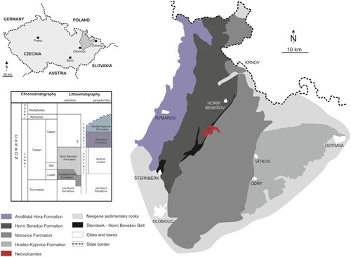
Within the NJU area, 146 abandoned underground mines were recently identified, mapped, and reviewed. We excluded the westernmost ∼5 km-wide strip of NJU, which is geologically and historically different. We then assembled a mine inventory focused mainly on the physical-geographical properties of the AUMs.
There is currently a lack of similar inventories. Existing databases concentrate on remediation and mine rehabilitation (CitationWerner et al., 2020; CitationMhlongo, 2015), mine management (CitationStanković et al., 2016), pollution (CitationKhalil et al., 2014) or safety and environmental concerns (CitationMackasey, 2000; CitationKim et al., 2016). By creating an interactive map with the collected data, we provide a complex information system describing the historical and natural heritage of the mines.
2. History and diversity of underground mines
The history of underground mining in NJU likely started by Pb-Ag ore excavation between the 10th and 12th centuries (CitationBakala, 1972). After 1989, the existing mines were determined to be unprofitable. In parallel, slate mining started from the sixteenth century (CitationWichert, 2020). The German experts traditionally used the Rhenish mining method characterised by a system of regular rooms (CitationJahn, 1917). The majority of slate was used in the mine as backfilling material (CitationWichert, 2020).
The Fire Patent (1785) issued by Emperor Joseph II contributed to the increase in slate mining. The law states that roofs should not be constructed from flammable material (CitationHrušecký, 1946). CitationJirásek et al. (2019) mentioned also rapid expansion caused by the construction of rail tracks after 1840. After the Second World War, German mining experts were deported from the country and the mines were confiscated (CitationJirásek et al., 2019). Many mines remained abandoned. Currently, only two mines remain in operation (CitationWichert, 2020).
The majority of abandoned mines preserved within the landscape of the NJU are short exploratory adits. Medium and large mines, however, are more complicated, often containing more than one entrance and multiple levels connected by vertical shafts or chimneys. Such mines may reach kilometres in total length, with depths up to 120 metres.
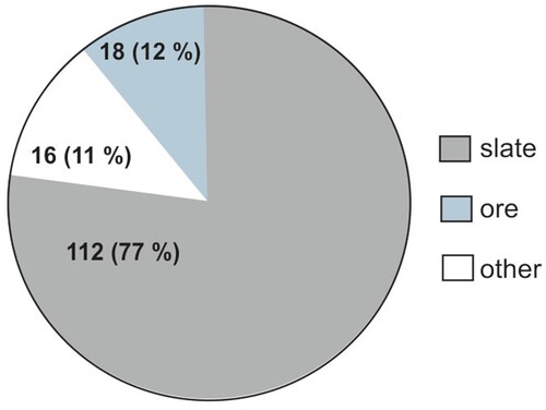
Other types of mines in the NJU area mostly include adits created during greywacke, sandstone or basaltic rock quarrying. History pertaining to these mines is mostly non-existent, with an occasional brief mention (CitationBarth, 1977; CitationKučera, 1948). Numbers of mines preserved in the NJU landscape are shown in . There are many other abandoned underground mines in adjacent areas awaiting exploration. These differ from those in the NJU in lithology and method of mining.
Figure 2. Types of mines detected in the investigated area.
3. Methods
3.1 Mapping of mines and identification of their key parameters
From 2016 to 2018, during the intensive field research, 146 mines have been identified, of which 137 have been investigated in detail (). Mine entrances were identified from web map applications, the Opava city archive; speleologists, campers, or locals. Each mine was inspected and mapped (). Within the mines, the following data capturing the current state (as opposed to the historical conditions) were noted: type of mine (index label: T-mine), length of mine (L-mine), number of accessible entrances (N-entry) and levels (N-lvl), horizontal diversity (H-diversity), vertical diversity (V-diversity), presence of fillings (Fillings), gravitational collapses (Collapse), water stream (W-stream), water body (W-body), artificial objects (Artificial), remnants of waste (Waste), secondary precipitated minerals (Minerals) and calcium carbonate forms resembling karst-forms (Karst).
Figure 3. Illustrative example of mapping and map processing, the Dřevěná štola slate mine.
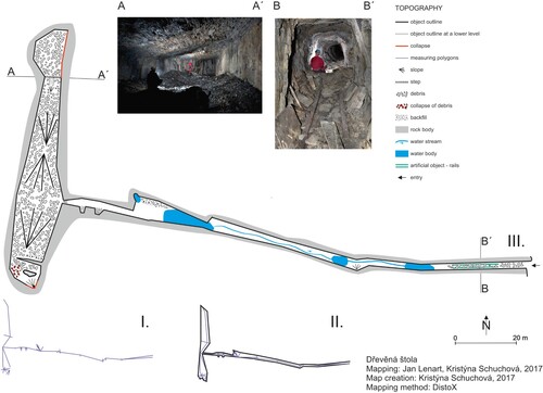
Table 1. Numbers of mines with detected parameters classified according to their length and numerical intensity index.
Speleological mapping was completed with compass and tape or by a system based on a Leica Disto A3 range-finder with a Disto-X component (CitationHeeb, 2008). The revised maps were then printed, and the approximate length of the AUMs was measured on the printed map using a ruler.
The AUMs were divided into three groups according to the T-mine parameter: S–slate, O–ore, and A–other mines. The mines were divided according to the L-mine parameter into small mines (<100 m), medium mines (101–500 m) and large mines (> 500 m). Numerical intensity indices (NI) were subjectively assigned to other recorded parameters: 0 – low intensity/no presence; 0.5 – mean intensity/occasional occurrence; 1 – high intensity/abundant occurrence ().
The H-diversity and V-diversity parameters express the horizontal and vertical branching of the mines. The V-diversity parameter is dependent on the number of levels. For mines with two or more levels, this parameter was set to 1.
3.2 Statistical analyses
The parameters listed in were used as variables for comparison to identify key linkages between them. N-lvl was coded as follows: 1–only one level, 2–two or more levels. The L-mine was transformed using a natural logarithm. The T-mine was taken as a nominal variable. The linkages between the variables were evaluated using three methods. If the explained variable and the explanatory variable were ordinal, nominal or binary, the χ2 test was used. If the explained variable was continuous and the explanatory variable was binary or ordinal, ANOVA was used. If the explained variable was ordinal and the explanatory variable was continuous, the linear regression was used.
Table 2. Statistical comparison between explained and explanatory variables: (–) not statistically dependent or probable, (0) unproven linkages, (*) weakly conclusive linkages, (**) moderately conclusive linkages, (***) strongly conclusive linkages.
4. Results and discussion
The resulting inventory contains data on 137 mines. The remaining nine mines were gated, flooded or collapsed. shows the numbers of mines classified into size categories and their NIs for each investigated parameter. The group of small-sized mines with NI = 0 is the most abundant. The majority of small mines are simple-shaped prospecting adits. Because the small mines tend to be relatively stable, they revealed a low abundance of both fillings and collapses (NI = 0). Water bodies were documented in 33 small mines, with an NI of 0.5 being the most common. Minerals and karst parameters were almost absent within the small mines.
For medium-sized mines, the majority of parameters are shifted to NI = 0.5. These mines are more branched. In 8 cases, the mines revealed 2 or more levels. A relatively high number of medium mines lack water bodies, minerals and calcium carbonate forms.
Large mines had the highest abundancy of both the NI = 0.5 and NI = 1 parameters. These mines are multibranched with more than two levels. All of the large mines contain filling and they are widely affected by gravitational processes. Only one mine was rated as stable (NI = 0).
4.1 Linkages between parameters
From all 90 theoretically possible linkages, 28 were tested and selected as demonstrable (). Trivial and meaningless linkages were eliminated. Moreover, W-stream, Artificial and Waste parameters were not evaluated due to their low frequency, which could not be statistically assessed. There are four groups of statistical linkages in the results: (i) unproven linkages (0); (ii) weakly demonstrable linkages (*) with significance levels at or below 0.05; (iii) moderately demonstrable linkages (**) with significance levels less than or equal to 0.01; (iv) strongly conclusive linkages (***) with significance levels less than or equal to 0.001.
4.1.1 Unproven linkages
The resulting example is the explained variable Collapse linked with the explanatory variables T-mine and Minerals. Even though different types of mines have different underground dimensions, which would presumably make them prone to different risks of collapse, this linkage has not been statistically proven. Furthermore, secondarily precipitated minerals may indicate mine sections with impaired rock mass stability, as they accompany tectonic dislocations with seeping or dripping water (CitationBotor et al., 2017; CitationZimák et al., 2005). However, this relationship has not been statistically proven either.
The different types of mines, excavated by different techniques, resulting in different mining forms, could influence the likelihood that water bodies are present. However, the relationship between the explained W-body and the explanatory T-mine was not statistically demonstrated. Even though the higher vertical diversity of the mine facilitates the vertical infiltration of water (CitationFalteisek et al., 2020), no relation was observed between W-body and V-diversity. Minerals such as iron oxides and hydroxides can be deposited by water precipitation (CitationDolníček, 2020). However, the relationship between explained Minerals and the explanatory W-body variable was not proven.
4.1.2 Weakly conclusive linkages
The Collapse and the W-body variables had a weak relationship, both in the role of explained and explanatory variables. This is probably because the collapsed rocks may prevent drainage, which resulted in water body development. The presence of water may gradually lead to further degradation, waterlogging or melting of the clay components between slate layers. These processes may result in repeated or gradual collapse.
In the case of the explained variable Minerals, there is a weak linkage with the explanatory variable Fillings. After the cessation of mining, the material left in the mine as filling underwent oxidation‒reduction processes, which resulted in the precipitation of secondary minerals such as gypsum or pyrite (CitationWichert, 2020; CitationVavro et al., 2018).
Finally, weakly conclusive linkages were found between the explained variable Karst and the explanatory variable Collapse. Collapses may often be predisposed by jointed or fault-disrupted rocks. Such sections contain both calcite veins and seeping water, which may eventually result in carbonate formations.
4.1.3 Moderately conclusive linkages
Unsurprisingly, N-lvl coincides with H-diversity. Furthermore, a higher number of levels and increasing length (explanatory L-mine, N-lvl) moderately increase the probability of collapse (explained Collapse) of incoherent lithological environments (CitationSchuchová & Lenart, 2020; CitationLongoni et al., 2016). The moderately proven relation between Karst and W-body variables may be explained by the evolution of typical calcareous microforms (stalagmites, flowstones, rimstones, mine pearls) bound to the aquatic environment (CitationHill & Forti, 1997; CitationManaka, 2021; CitationMelim & Spilde, 2021; CitationBroughton, 2020; CitationMackin & Coombs, 1945).
4.1.4 Strongly conclusive linkages
Presumably, the explained L-mine variable is correlated with the explanatory N-lvl variable. The higher the number of individual levels, the longer the mine. Similarly, the explained H-diversity variable is strongly linked with the mine length (L-mine explanatory variable).
The greatest number of strongly conclusive linkages was connected with the Fillings variable. Their abundant occurrence is explained by increasing length of mine and a high number of levels and thus is significantly higher with increasing H-diversity and V-diversity. This is consistent with historical mining principles in which many sections of large, multilevel mines were traditionally backfilled.
The explained Collapse variable was significantly linked with the Filling explanatory variable. This linkage may be coincidental. However, gravitationally affected portions of the mine (e.g. along fault zones, folded ceilings) were traditionally backfilled to prevent further collapsing. After many years of abandonment, this preventative measure is only partially effective. Moreover, the filling itself could be prone to collapse.
The W-body explained variable is strongly connected with the Karst explanatory variable. Moreover, both W-body and Karst occurrence may be explained by the increasing length of the mine. This result shows that underground water enriched with calcite commonly penetrates the rock massif. In large mines, calcium carbonate forms were not so common, but if they were detected, they were well developed (CitationCarbone et al., 2016; CitationSawłowicz et al., 2014; CitationMelim & Spilde, 2021).
The Minerals variable is strongly correlated with the L-mine, H-diversity and Karst variables. Various types of secondary minerals (CitationWichert, 2020) are more likely to precipitate within large mines with a complex array of underground geomorphic forms. The strong linkage between the Minerals and Karst variables signifies their common parallel occurrence (CitationVavro et al., 2018; CitationHill & Forti, 1997).
5 Conclusion
This paper presents an example of the complex inventory of abandoned underground mines based on physical-geographical parameters. The inventory is supported by the web map processed in ArcGIS Online. The 146 identified mines were of three types: slate mines (112 mines), ore mines (18) and other mines (16). Most of the 137 investigated mines were of small size (102 mines), with 25 medium-sized mines and only 10 large mines exceeding 500 m in length.
In each mine, twelve additional parameters and their occurrence were recorded. Statistical evaluation revealed some unsurprising connections between them. The longer the mine is, the more levels there are and the higher the spatial diversity is. The highest horizontal and vertical diversities were detected in the large mines. Of all mines investigated, 90% of the large mines had the highest horizontal diversity, and 80% of them had the highest vertical diversity. Overall, the length of the mine was the main factor explaining the occurrences of the seven investigated parameters.
Fillings were common, especially in branched medium and large mines with high vertical and horizontal diversity. However, their occurrence is limited. In the case of small mines, fillings occurred rather sporadically. For medium-sized mines, a moderate grade of filling is recorded in 60% of the investigated sites; for large mines, it rises to 80%.
The expected relation was strongly conclusive between the gravitational collapse parameter and mine length, number of levels and presence of fillings. The most stable were the small mines (72%), in which only 5% reached a high intensity of gravitational collapsing. Medium-sized mines were stable in 36% of cases, whereas large mines in only 10% of the cases. Generally, only some portions of the mines were affected by gravitational failures (56% of medium and 80% of large mines). Two medium mines (8%) were highly affected by collapse, which may be the beginning of gradual catastrophic termination of their existence.
Databases of anthropogenic objects, including abandoned mines, may help us to better understand the shape of history, as well as to better understand the recent natural processes impacting these abandoned objects. Such knowledge may contribute to the successful management and protection of underground abandoned mines.
Software
A map of the NJU with AUMs was created in ArcGIS Online as a Web map application: https://www.arcgis.com/apps/webappviewer/index.html?id=48e5fc661ea44b6bbd59b02d879437e6 Original data were processed in ArcGIS Desktop software. The web map allows user to zoom in on clusters of mines to obtain a detailed view, use different layers according to the actual scale of the map and view all attributes in a pop-up window. As a topographical base, we used the Esri World Shaded Relief layer combined with selected features (rivers, water bodies, developed areas, roads and railways) from the DATA200 and DATA50 datasets provided by the Czech Office for Surveying, Mapping and Cadastre and a simplified geological map based on the data provided by the Czech geological survey. The overall appearance of the web map was designed with darker tones, which should evoke a subterranean environment or Carboniferous flysch rocks. AUMs are marked on the map with symbols scaled by length (three size categories) and coloured by their type (slate, ore, other). All mapped parameters and photos are available in a pop-up window. The resulting map thematically follows the map from CitationLenart and Miklín (2016), which shows a map of pseudokarst caves located ∼50 km from the area described in this paper.
Declaration of interest
The authors report there are no competing interests to declare.
Supplemental Material
Download Zip (1.6 MB)Data availability statement
The authors confirm that the data supporting the findings of this study are available within the article and its supplementary materials. Maps of the mines are available from the corresponding author, Jan Lenart, [email protected], upon reasonable request.
Disclosure statement
No potential conflict of interest was reported by the author(s).
Correction Statement
This article has been corrected with minor changes. These changes do not impact the academic content of the article.
Additional information
Funding
References
- Bakala, J. (1972). Počátky těžby kovů v Nízkém Jeseníku a vznik Horního Benešova. ČSM B, 21, 161–179.
- Barth, V. (1977). Čedičové vulkány střední části Nízkého Jeseníku. Časopis pro mineralogiia geologii, 22(3), 279–289.
- Botor, D., Toboła, T., & Jelonek, I. (2017). Thermal history of the lower Carboniferous Culm Basin in the Nízký Jeseník Mts. (NE Bohemian Massif, Czech republic and Poland). Annales Societatis Geologorum Poloniae, 87(1), 13–40. https://doi.org/10.14241/ASGP.2017.002
- Broughton, P. L. (2020). Zn2+-Pb2+-doped calcite shrub fabrics: Abiotic morphogenesis of travertine-like dripstone encrustation at the Jersey Zinc Mine, Southeastern British Columbia. American Journal of Science, 320(10), 851–891. https://doi.org/10.2475/12.2020.02
- Carbone, C., Dinelli, E., & Waele, D. J. (2016). Characterization of minothems at Libiola (NW Italy): Morphological, mineralogical, and geochemical study. International Journal of Speleology, 45(2), 171–183. https://doi.org/10.5038/1827-806X.45.2.1944
- Demek, J., Mackovčin, P., Balatka, B., Buček, A., Cibulková, P., Culek, M., Čermík, P., Dobiáš, D., Havlíček, M., Hrádek, M., Kirchner, K., Lacina, J., Pánek, T., Slavík, P., & Vašátko, J. (2006). Hory a nížiny. Zeměpisný lexikon ČR, 1–582.
- Dolníček, Z. (2020). Recentní vznik limonitové bahení železné rudy v Hulíně (niva řeky Moravy). Bulletin Mineralogie Petrologie, 28(2), 2570–7345.
- Falteisek, L., Drahota, P., Culka, A., Laufek, F., & Trubač, J. (2020). Bioprecipitation of As4S4 polymorphs in an abandoned mine adit. Applied Geochemistry, 113, 104511. https://doi.org/10.1016/J.APGEOCHEM.2019.104511
- Heeb, B. (2008). Paperless Caving - An Electronic Cave Surveying System. 4th European 782 Speleological Congress, 1–4.
- Hill, C. A., & Forti, P. (1997). Cave Minerals of the World: 2nd Edition, in: National Speleological Society, Huntsville. National Speleological Society, Huntsville, Alabama, 285–287.
- Hrušecký, J. (1946). Dolování pokrývačských břidlic na severozápadní Moravě a ve Slezsku. Horník, 2(3), 42–44.
- Jahn, J. (1917). Pamětní spis o nerostných pokladech Moravy. Moravskoslezský zemský národní výbor, 1, 1–77.
- Jirásek, J., Matýsek, D., Přibil, M., Šmehil, K., & Minaříková, A. A. (2019). Slate industry at zálužné -mokřinky area (Silesia, czech republic) and its associated supergene minerals. Bulletin Mineralogie Petrologie, 27(1), 89–108.
- Khalil, A., Hanich, L., Hakkou, R., & Lepage, M. (2014). GIS-based environmental database for assessing the mine pollution: A case study of an abandoned mine site in Morocco. Journal of Geochemical Exploration, 144(part C), 468–477. https://doi.org/10.1016/j.gexplo.2014.03.023
- Kim, S. M., Suh, J., Oh, S., Son, J., Hyun, C. U., Park, H. D., Shin, S. H., & Choi, Y. (2016). Assessing and prioritizing environmental hazards associated with abandoned mines in Gangwon-do, South Korea: The Total Mine Hazards Index. Environmental Earth Science, 75, 369. https://doi.org/10.1007/s12665-016-5283-4
- Kučera, K. (1948). Moravskoslezské horniny a jejich užití na silnicích. Ministerstvo techniky v Praze. Brno, 1–107.
- Lenart, J., & Miklín, J. (2016). Pseudokarst caves of the Outer Western Carpathians, Czechia. Journal of Maps, 13(2), 37–46. http://doi.org/10.1080/17445647.2016.1252804
- Longoni, L., Papini, M., Brambilla, D., Arosio, D., & Zanzi, L. (2016). The risk of collapse in abandoned mine sites: the issue of data uncertainty. Open Geosciences, 8(1), 246258. https://doi.org/10.1515/geo-2016-0022
- Mackasey, W. O. (2000). Abandoned mines in Canada. Prepared for Mining Watch Canada. WOM Geological Associates Inc., 1–11
- Mackin, J. H., & Coombs, H. A. (1945). An Occurrence of “Cave Pearls” in a Mine in Idaho. Journal of Geology, 53(1), 58–65. https://doi.org/10.1086/625245
- Manaka, M. (2021). Morphology, mineralogy, and chemistry of ocherous precipitate aggregates downstream of an abandoned mine site. Minerals, 11(1), 1–13. https://doi.org/10.3390/min11010032
- Melim, L. A., & Spilde, M. N. (2021). The rise and fall of cave pearl pools: Highly variable growth recrystallization and demise of a mine pearl site. Sedimentology, 68, 2165–2194. https://doi.org/10.1111/sed.12848
- Mhlongo, E. S. (2015). A review of problems and solutions of abandoned mines in South Africa. International Journal of Mining, Reclamation and Environment, 30(4), 1–16. https://doi.org/10.1080/17480930.2015.1044046
- Sawłowicz, Z., Przybyło, J., & Boroń, K. (2014). Colourful speleothems in the Wieliczka Salt Mine. Geological Quarterly, 58(3), 449–458. https://doi.org/10.7306/gq.1155
- Schuchová, K., & Lenart, J. (2020). Geomorphology of old and abandoned underground mines: Review and future challenges. Progress in Physical Geography: Earth and Environment, 44(6), 791–813. https://doi.org/10.1177/0309133320917314
- Stachowiak, A. (2013). Geostrada Sudecka : Przewodnik geologiczno-turystyczny. Państwowy Instytut Geologiczny.
- Stanković, R., Vulović, N., Lilić, N., Obdadović, I., Tošović, R., & Pešić-Georgiadis, M. (2016). A WebGIS decision supporst system for management of Abandoned Mines. Energies, 9(7), 567. https://doi.org/10.3390/en9070567
- Vavro, M., Souček, K., Daněk, T., Matýsek, D., Georgiovská, L., & Zajícová, V. (2018). Utilization X-ray computed micro-tomography to evaluate iron sulphide distribution in roofing slates. Quarterly Journal of Engineering Geology and Hydrogeology, 51, 169–178. https://doi.org/10.1144/qjegh2016-108
- Werner, T. T., Bach, M. P., Yellishetty, M., Amirpoorsaeed, F., Walsh, S., Miller, A., Roach, M., Schnapp, A., Solly, P., Tan, Y., Lewis, C., Hudson, E., Heberling, K., Richards, T., Chia, C. H., Truong, M., Gupta, T., & Wu, X. (2020). A geospatial database for effective mine rehabilitation in Australia. Minerals, 10(9), 1–745. https://doi.org/10.3390/min10090745
- Wichert, J. (2020). The Origin of Slate. Slate as dimension stone : Origin, standards, properties, mining and deposits. Springer. 1–492. https://doi.org/10.1007/978-3-030-35667-5_2
- Zimák, J., Novotný, P., & Dobeš, P. (2005). Hydrothermal mineralization at Domašov nad Bystřicí in the Nízký Jeseník Uplands. Bulletin of Geosciences, 80(3), 213–221.