
ABSTRACT
We present the geological map (1:10.000) of the Montecastelli Pisano area, where (i) the relationships between Neogene-Quaternary transfer and normal faults have been carefully mapped (Sheet 1), and (ii) the mantle sequence of the Ligurian Ocean has been analysed (Sheet 2). Fault analyses allowed to define: (i) NE-trending fault system (left-lateral strike- to oblique-slip faults) belonging to a transfer shear zone; and (ii) NW-trending normal to oblique-slip faults. Their evolution is framed in the extensional tectonics affecting the Northern Apennines since Early-Middle Miocene. The ophiolite complex is constituted by serpentinized spinelharzburgite with minor serpentinized dunite channels cut by gabbro dykes. A km-scale cataclastic zone cut the mantle section, locally hosting Cu-Fe mineralization. The goal of this work is to present the distribution of the main fractures affecting an area where the occurrence of ophiolite can favor the success of the CO2 reinjection project.
1. Introduction
This geological map has been developed in the framework of the H2020-GECO project (https://geco-h2020.eu/), aimed at understanding the appropriate locations for CO2 re-injections in the NE-side of the Larderello geothermal area ((a)). It results from a geological survey in the area of Montecastelli Pisano ((a)). This case study allows us to define (i) the definition of the local structural features for evaluating the potential injection site and (ii) to enforce the study of the ophiolite section where the relationships between different ultramafic and mafic lithotypes are preserved, providing a framework for the evaluation of the potential for CO2 storage through mineral carbonation (CitationBoschi et al., 2009; CitationBoschi et al., 2017; CitationBoschi et al., 2020; CitationRielli et al., 2021).
Figure 1 . Geological sketches illustrating the evolution of Northern Apennines: (a) Structural sketch map illustrating the relationships between the main Pliocene-Pleistocene basins and transfer zones in Tuscany. Symbols: 1 – inner Northern Apennines: this domain is characterized by a 22–24 thick crust; 2 – outer Northern Apennines with a 35–40 thick crust; 3 – Outcropping or drilled magmatic bodies; these are mainly located along the transfer zones (after CitationDini et al., 2008); 4 – transfer zones; 5 – normal faults; 6 – thrusts; 7 – Pliocene-Pleistocene marine to continental sediments; 8 – metamorphic rocks; (b) relationship between the different tectonic units of inner northern Apennines and related paleogeographic domains; (c) schematic geological cross-sections showing the collisional and post-collisional evolution in the inner zone of the northern Apennines (after CitationLiotta et al., 2021, modified).
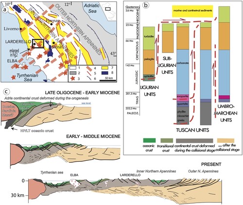
The study area is located in the Inner Northern Apennines ((a)), an Alpine collisional belt derived from the convergence (i.e. the closure of the Ligurian Ocean: Jurassic- middle Eocene) and collision (middle Eocene – Early Miocene) between the Adria microplate and Corsica-Sardinia massif, of African and European pertinence, respectively (CitationMolli, 2008). This process gave rise to stacked tectonic units deriving from internal and external oceanic (Ligurian), transitional (Sub-Ligurian) and continental (Tuscan) domains ((b)), with the latter having experienced HP-metamorphism, later overprinted by LP-metamorphism, during the exhumation process (CitationTheye et al., 1997; CitationBrunet et al., 2000; CitationRossetti et al., 2002; CitationBrogi & Giorgetti, 2012; CitationBianco et al., 2019). During Miocene ((c)), the Inner Northern Apennines were affected by polyphase extensional tectonics (i.e. CitationCarmignani et al., 1994; CitationDallmeyer & Liotta, 1998) causing (): (i) lateral segmentation of the most competent units, (ii) the consequent back-rotation of pre-existing structures, and (iii) the formation of tectonic depressions in between segmented units (i.e. synformal or bowl-shaped basins), where Miocene continental to marine sediments were deposited (CitationBrogi, 2004; CitationBrogi et al., 2005; CitationBrogi & Liotta, 2008; CitationBarchi, 2010). Since the Pliocene, high-angle normal faults cross-cut the older structures, forming accommodation space for marine to continental Pliocene-Pleistocene sediments (CitationBrogi, 2011, Citation2020; CitationMartini et al., 2021). The extensional tectonics migrated eastward coevally with anatectic and subcrustal magmatism (CitationSerri et al., 1993; CitationMolli, 2008) and led to a present crustal and lithospheric thickness of about 24 and 40 km, respectively (CitationCalcagnile & Panza, 1981; CitationCassinis et al., 2003; CitationDi Stefano et al., 2011), heat flux of about 120 mW/m2 on average (CitationDella Vedova et al., 2001) and positive gravimetric anomalies (CitationCassinis et al., 2003). At least since Late Miocene, extension developed through the interplay between normal and transfer faults, NW- and NE-trending respectively (CitationLiotta, 1991; CitationDini et al., 2008; CitationLiotta et al., 2015; CitationLiotta & Brogi, 2020), allowing the development of NW-SE striking basins ( and ), where continental to marine sedimentation developed (CitationMartini & Sagri, 1993).
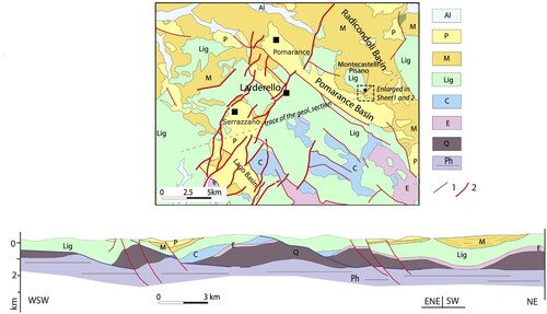
Figure 2 . Map and cross section illustrating the structural context in which the study area is located. The cross section illustrates the middle-late Miocene extensional structures determining the lateral segmentation of the geological bodies. The Pliocene-Present fault system is also displayed leading to the development of the Pliocene sedimentary basins. Symbols: Al – alluvial and colluvial deposits; P – marine sediments (Pliocene); M – continental to marine sediments (Serrravallian-Messinian); Lig – magmatic and sedimentary rocks related to the Oceanic and Transitional crust (Ligurian and sub-Ligurian Domains, Jurassic-Oligocene); Continental Domain (Tuscan Domain): C – Carbonate and terrigeneous succession (Jurassic-late Oligocene/early Miocene); Ev – Evaporite (late Trias); Q – mainly quartzite (Trias-Paleozoic); Ph – mainly phyllite (Paleozoic); 1 – Miocene extensional faults; 2 – Pliocene extensional faults. After CitationBrogi and Liotta (2008) and CitationLiotta and Brogi (2020).
In the study area, the exposed ophiolite succession belongs to the Ligurian Ocean and it is considered as a fossil analogue of current slow- to ultra-slow spreading ocean floors (CitationPiccardo et al., 2014). The evolution of the ophiolite succession resulted from an early amagmatic stage, where sub-continental garnet lherzolite, was decompressed and transformed in to porphyroclastic/banded spinel lherzolite. The lithospheric extension during the ocean spreading facilitated passive adiabatic upwelling and the consequent decompression induced-partial melting of the asthenosphere, thus resulting in melt infiltrations through the lower lithospheric mantle (non-extrusive magmatic stage). It corresponds to small volumes of undersaturated melt reasonably percolated along coeval extensional shear zones and reacted with lherzolite. Dissolution of pyroxene and crystallization of olivine produced masses and bands of spinel harzburgites and dunites. The increased partial melting and the structural deepening of the melting zone produced MORB melts (CitationPiccardo et al., 2014) that migrated to shallow levels, producing large dunite channels by pyroxene dissolution (magma transfer zone; CitationMontanini et al., 2012 with ref. therein).
In spite of this regional understanding, no detailed geological maps are focussed on brittle transfer zones, their relationship with the coeval tectonic depressions, and on the architecture of the ophiolite sequence in Southern Tuscany. This is what we present with the new geological maps at 1:10,000 and 6000 scale, respectively reported in Sheet 1 and 2.
2. Methods
The geological map (Sheet 1) was produced at 1:10.000 scale and covers an area of about 77 km2. Field data acquisition was based on topographic maps (https://www.regione.toscana.it/-/cartografia-tecnica-regionale-e-scarico-dati-geografici) and was performed by using Fieldmove software from PETEX (petroleum experts, https://www.petex.com).. The dataset has also been managed through the open-source software QGIS (GNU General Public License; https://www.gnu.org//licences). Outcrops and measures on the main structural (i.e. faults and shear zones) and stratigraphic (i.e. bedding) elements have been reported on a topographic map and then both stratigraphic and tectonic contacts have been manually drawn. Then, the handmade map has been digitized and redrawn with arcgis (https://www.esri.com/it-it/arcgis/products/arcgis-pro/overview) and later by Adobe Illustrator software (https://www.adobe.com/it/products/catalog.html) for the final editorial version. Structural data have been analysed using Stereonet v11 (http://www.geo.cornell.edu/geology/faculty/RWA/programs).
With the same methodology, 1:6.000 scale map has been dedicated to the ophiolite complex (Sheet 2). Petrographic analyses were carried out by optic, scanning electronic microscopy and X-ray diffraction, when necessary to characterize representative samples.
3. Stratigraphic succession
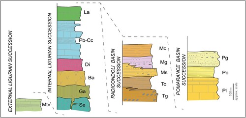
As a result of fieldwork and petrographic analyses, the detailed stratigraphic succession of the study area () is described in the following paragraphs. Ages are from CitationLazzarotto et al. (2002). Abbreviations used in the map and cross-sections are referred to formational names and are enclosed in parentheses. The description starts from the bottom, with formations belonging to the external and Internal Ligurian Domains. Late Miocene sediments (Radicondoli Basin succession) and Pliocene-Pleistocene deposits (Pomarance Basin succession), unconformably rest on the Ligurian units, respectively to the east and the west of the mapped area.
Figure 3 . Stratigraphic logs of the study area. Symbols and colors as in Sheet 1 and 2.
3.1. External Ligurian domain
It is represented by a tectonic unit (Flysch calcareo-marnoso, in: CitationMazzanti, 1966; CitationLazzarotto & Mazzanti, 1978) that tectonically overlies the Late Triassic evaporite level of the Tuscan Domain and, locally, the terrigenous Tuscan succession the (i.e. Macigno Fm, see geological sections in Sheet 2). On the whole, this tectonic unit is composed of late Cretaceous-early Paleocene calcareous-marly-arenaceous succession exceeding 300 m in thickness. The basal part (Poggio Rocchino Fm, Roc) is up to 100 m thick and consists of shale levels and cm- to dm-thick calcilutite, calcarenite and calcareous-micaceous sandstone beds. The upper part of the succession (Monteverdi Fm, Mtv), is made up of m-thick calcilutite and calcarenite, with widespread bioturbations and groove casts and passing to dm-thick marl and shale beds. Locally, the calcarenite is grading upward into about 2 m-thick massive, locally laminated, marl beds. Finally, up to 10 m thick gray to black shale with cm- to dm-thick calcareous sandstone can be interbedded within the calcarenite and marly levels.
3.2. Internal Ligurian domain
It consists of a tectonic pile formed by 7 main tectonic units, delimited by extensional faults ((a)). The base of the succession is mainly formed by the oceanic crust and lithospheric mantle rocks of the Montecastelli Ophiolite Complex (MOC; Sheet 2). Such a complex, Jurassic in age (CitationLazzarotto et al., 2002), is mainly exposed NE of the Montecastelli village. Petrological analyses of typical serpentinite from the study area and from nearby ophiolitic complex, are reported in Boschi et al. (Citation2009, Citation2017) and CitationRielli et al. (2021, Citation2022). MOC is dominated by a middle-late Jurassic serpentinized spinel harzburgite (Se; (a)) cut by sub-horizontally to shallow-dipping serpentinized spinel dunite channels (Dun) with thickness ranging from few decimeters to several meters thick ((b, c)). Locally, the serpentinized harzburgite is cut by sub-vertical gabbro (Ga; (d, e)) and basalt dikes, with thickness ranging from few decimeters to 1–2 meters, and intruded by gabbroic laccolites, which reach thickness of ∼ 140 meters. This sequence is directly overlain by a succession of gabbro, basalts with pelagic sediments on top, showing sub-parallel contacts. Basaltic dikes also cut the gabbroic bodies ((f)). Locally, the gabbro and/or basalt sequences result discontinuous and/or with differences in their thickness, as an effect of the Miocene extensional tectonics. In this case, the pelagic sediments lay directly onto the serpentinized harzburgite (Sheet 2).
Figure 4 . Ttectonic evolution of the study area. (A) succession of the external Ligurian unit, with indications of the competent (more rigid) and less competent levels, influencing the evolution of the lateral segmentation of rocks during Miocene extension; (B) stratigraphic columns illustrating the part of the outcropping succession, testifying the occurrence of a tectonic unit, delimited by extensional shear zones; (C) conceptual model illustrating the evolution of the Ligurian rocks, during collision and subsequent extension; (D) structural sketch showing the relation between the Ligurian tectonic units and the Neogene Basins.
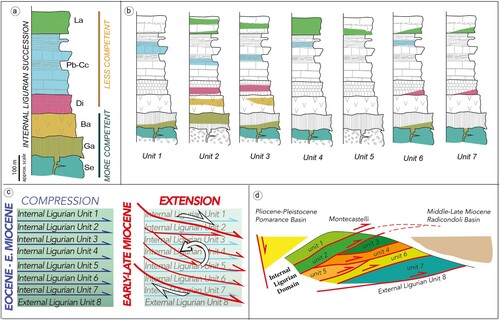
Figure 5 . (A) Panoramic view showing the tectonic contact between basalt and gabbro overlapping serpentinized spinel harzburgite and basalt; (B) serpentinized spinel dunite channel cutting serpentinized spinel harzburgite. The whitish color of dunite is due to the precipitation of hydrous carbonates as a result of the spontaneous carbonation of this lithology; (C) Close up view of serpentinized spinel dunite, with bright green areas constituted by serpentine and black veins made by magnetite. White portions in the veins are due to incipient carbonation; (D and E) Sub-vertical gabbro dike cutting the serpentinized spinel-harzburgite; (F) Basalt dikes cutting a gabbro laccolith.
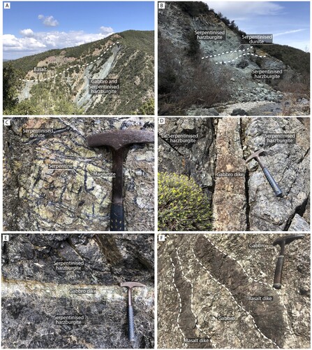
The contact between the main spinel harzburgite body and the gabbro is sub-horizontal to NE- dipping (from 30 to 48˚) in the northern portion of the ophiolite complex while it becomes predominantly sub-horizontal in its southern portion. Basalt shows always a sub-horizontal attitude with respect to the underlying gabbro or spinel harzburgite. Gabbro dikes are always sub-vertical and form swarms (up to 10 dikes) sharing the same orientation and mineralogy at local scale (Sheet 2).
Gabbro dikes cut the dunite channels indicating their later emplacement. Dunite channels ((b)) were identified across all the serpentinized harzburgitic body. Their attitude is sub-horizontal to shallow-dipping, forming channels with a lateral continuity through the entire ophiolite complex (Sheet 2). Two main levels of dunite with sub-parallel channels have been mapped, thanks to their characteristic pattern marked by a black reticulate of magnetite-rich veins on a yellowish-greenish background, resembling frog skin ((c)). The occurrence of highly reactive brucite ((b)) is responsible for the diffuse ongoing carbonation (hydromagnesite, nesquehonite and Mg-Fe layered double hydroxides) of this formation (CitationBoschi et al., 2017, Citation2020). A km-scale cataclastic zone cut approximately the exposed portion of the ophiolite complex (Sheet 2). This is constituted by rounded to angular fragments of serpentinized dunite, serpentinized harzburgite and gabbro ranging from m- to dm- size, embedded in a soapy matrix of chlorite, Fe-rich serpentine, Ca- rich amphibole, andradite and xonotlite (CitationBoschi et al., 2020). The cataclastic zone can host small Cu-Fe sulfide mineralization, formed during the Jurassic in the oceanic crust (CitationDini & Boschi, 2017; CitationBoschi et al., 2020).
Locally, the ophiolite complex is stratigraphically overlain by the late Jurassic-Cretaceous sedimentary cover, mainly represented by red radiolarite and siltstone (Diaspri Fm, late Jurassic, Di). It is composed of cm- to dm-thick beds interlayered with mm-thick shale. The Early Cretaceous Calpionellae-bearing limestone (Calcari a Calpionelle Fm) is mainly composed of dm- to m-thick siliceous calcilutite beds with interlayered mm- to cm-thick shale. At its top, the terrigeneous component is progressively dominant passing to dm-thick limestone and dm- to m-thick shale and marl beds (Argille a Palombini Fm, Early Cretaceous, (a)) with occasional quartz-sandstone levels, forming sedimentary bodies up to 15 m thick. Calcari a Calpionelle Fm and Argille a Palombini Fm (Cc-Pb) are jointly mapped in Sheet 1.
Figure 6 . Examples of lithotypes characterizing the pre-Neogene Substratum. (a) Creataceous limestone and shale (Argille a Palombini Fm); (b) sedimentary ophiolitic breccia (Lanciaia Fm [early-middle Eocene]).
![Figure 6 . Examples of lithotypes characterizing the pre-Neogene Substratum. (a) Creataceous limestone and shale (Argille a Palombini Fm); (b) sedimentary ophiolitic breccia (Lanciaia Fm [early-middle Eocene]).](/cms/asset/178a31a8-a761-4541-a62e-ac7b61c3118c/tjom_a_2242723_f0006_oc.jpg)
The above-described succession is unconformably overlain by Paleocene-Eocene thrust-top basin deposits, referred to the Lanciaia Fm (La) (CitationSignorini et al., 1963). It is composed of sedimentary breccias, consisting of dismembered ophiolite blocks and their original sedimentary cover. Blocks and/or cobble-sized gravel are mostly made up of serpentinite and gabbro, and subordinately by limestone and radiolarite ((b)). Breccia levels are made up of clast-supported boulders and gravel deposits, moderately to well-rounded pebbles, with a scarce internal fabric organization. In some cases, sorted pebbles occur in inversely graded tabular beds, up to 5 m thick. A quartz-micaceous sandstone deposit, up to 25 m thick, is then exposed at the top of the breccia level.
3.3. Radicondoli Basin succession
The sediments record of the Radicondoli Basin exposed in the geological map (Sheet 1) are part of the Tortonian-Messinian continental to marine succession (CitationBossio et al., 1993) belonging to the 2nd Unconformity Bounded, Stratigraphic Unit described for this basin (see CitationBonini & Moratti, 1995; CitationBrogi & Liotta, 2008), unconformably resting on the basin substratum. The lower stratigraphic unit reported in the map (Luppiano Fm, Tg, and Fosci Fm, Tc) consists of late Tortonian (Turolian) succession, at least 150 m thick, mainly made up of fluvio-lacustrine pebble to cobble-sized gravel and interbedded clay levels (Luppiano Fm, Tg) laterally passing to clay and silty-clay. Gravel levels, 1–15 m thick, are mainly concentrated at the base of the succession, near the contact with the basin substratum, and are made up of clast-supported, moderately rounded, pebbles to boulders, with a scarce internal fabric organization. Inversely graded tabular beds, up to 5 m thick, are delimited, at the top, by clayey levels. The gravel levels laterally pass to lacustrine lignite-bearing clay and sandy-clay with interlayered marl and pebble-sized gravel lenses (Fosci Fm, Tc). At the top of the clay and sandy-clay succession, well-cemented sandstone and sandy-conglomerate beds occur (Torrente Sellate Fm, Ms), up to 100 m thick, in total. These form meters-thick beds, heteropic with the upper part of the lacustrine lignite-bearing clay and sandy-clay. These units are then overlain by about 60 m thick, early Messinian sandstone, marl and lagoonal gyps-arenite levels (Raquese Fm, Mg), interbedded with fibrous gypsum-bearing laminae, microcrystalline gypsum aggregates (alabaster nodules) and pebble-sized conglomerate lenses. Finally, the Raquese Fm is covered by the early Messinian marine Pycnodonta-bearing clay succession (70 m thick, at least), locally characterized by interlayered beds of sand and pebbly-sized clast-supported gravel (Era Morta Fm, Mc). Sand beds consist of medium- to fine-grained massive to laminated levels while the pebbly-sized gravel levels are lenses up to 3 m thick.
3.4. Pomarance Basin succession
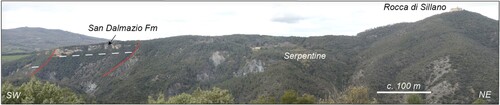
The sedimentary succession filling the Pomarance Basin (CitationBossio et al., 1993) is mainly exposed in the western and south-western side of the geological map (Sheet 1). The basal part of this succession consists of late Pliocene, up to 220 m thick, carbonate and terrigenous succession made up of fossiliferous limestone, calcarenite and calcirudite (San Dalmazio Fm, Pl), and of marine clay and sandy clay (Argille Azzurre Fm, Pc). Limestone, calcarenite and calcirudite beds are organized in laterally continuous massive or laminated beds, up to 3 m thick, interlayered with cm to dm-thick sandstone and sandy-claystone levels. To the top and laterally, the San Dalmazio Fm passes to Piacenzian clay and sandy-clay (Argille Azzurre Fm, Pc). These latter sediments consist of massive clay, locally fossiliferous with interbedded sandy levels, up to 80 m thick, in the whole, and rests uncomformably on the pre-Neogene substratum () and Miocene sediments (Sheet 1).
Figure 7 . Panoramic view illustrating the relationships between the Piacenzian San Dalmazio Fm and the pre-Neogene substratum, here defined by ophiolitic rocks.
This Piacenzian succession is unconformably overlain by continental deposits (Chiusdino Fm; CitationSignorini, 1966), which consists of Piacenzian-Gelasian alluvial sediments, up to 100 m thick. These are made up of moderately to well-rounded pebble to cobble-sized clast-supported gravel with interbedded clay-silty and sandy levels. These latter consist of 1–20 m thick bodies, which show mostly concave basal surfaces and scarce internal fabric organization. In some cases, sorted pebbles to boulders occur in disorganized or inversely graded, tabular beds up to 1 m thick, with imbricated fabrics. The clay-silty levels consist of gray to dark-gray bedded or massive tabular strata ranging in thickness from 10 to 300 cm. Medium- to fine-grained sandy levels occur as isolated lenses, up to 5 m thick and at least 50m long along strike, with massive to laminated internal fabrics.
3.5. Subsurface data
Boreholes drilled during geothermal exploration reached the Tuscan units, derived from the continental Tuscan Domain (CitationCarmignani et al., 1994), below the stacked Ligurian units (Sheet 2). The Tuscan units are represented by the Triassic phyllite and quartzite (Verrucano Group, Ver) and to the late Triassic evaporite level (Burano Fm, Ev), both involved in duplex structures during the collisional stage of the Northern Apennines (CitationPandeli et al., 1991). The late Oligocene-Early Miocene quartz-feldspar turbiditic succession forming the upper part of the Tuscan succession (i.e. Macigno Fm, Mac), unconformably rests on the Triassic succession due to low-angle normal faults related to the late Miocene extensional tectonics.
4. Structures
The stacked Ligurian Units, doubled during the orogenic event (Cretaceous-Early Miocene), were affected, during middle-late Miocene, by extensional shear zones now delimiting seven different tectonic units (), each one characterized by the partial occurrence of the original oceanic succession ((b)). Block-rotation occurred during the extensional shearing (CitationBrogi, 2004) and caused the tilting of the structures, now W-dipping ((c, d)). A clear example of this deformation can be observed to the north of the Montecastelli village where low-angle shear zones delimiting the tectonic units are gently dipping toward West. Where the ophiolitic complex is involved, the deformation is partitioned and concentrated in talc-rich domains within the serpentinized harzburgite. Shear zones range from cataclastic to ultramylonitic. Calcite and magnesite millimeter to centimeter-thick veins form a diffuse network within the shear zone, suggesting the role of fluids in enhancing shearing. In this case, the cataclastic shear zones are formed by foliated blocks of gabbro and harzburgite, embedded in a cemented matrix made up of the same lithotypes, mixed with clasts from the sedimentary succession. The mylonitic to ultramylonitic shear zone can be up to 25 m thick. All previously formed structures are then cross-cut by three different fault systems, NE-, NNE- and NW-striking, respectively.
The NE-striking fault system can be mapped in the whole study area although these are more common nearby Montecastelli, to the South, and Lanciaia, to the North, within an area of about 3 km wide. Here, the NE-striking fault system is formed by sub-parallel fault segments up to 2 km long.
The NNE-striking faults form splay structures associated to the NE-trending faults described above. The angular relationships between the two fault systems suggests a main left-lateral kinematic component of the faults.
The NW-striking fault system is well defined in the western part of the study area, where these faults juxtapose the Pliocene-Pleistocene sediments of the Pomarance Neogene Basin with the Ligurian Units. The NW-striking faults are commonly dissected by the NE-striking fault system.
Concerning the faults kinematics, data have been collected in few exposures due to outcrop issues. Collected data are summarized in (). Kinematic indicators consist of slickenlines, in the Neogene deposits, and slickenlines, calcite fiber steps and chatter marks in the pre-Neogene units.
Figure 8 . Summary of the collected kinematic data on mesa-faults. The Stereonet (lower hemisphere, equal angle projection) summarize the attitude of the measured meso-fault planes and their kinematic indicators. (a) first kinematic event on NE-trending fault system; (b) second kinematic event on NE-trending fault system; (c) outcrop example of striation illustrating an almost pure left lateral strike-slip movement on NE-trending fault slip plane; (d) fault surface, enlarged in (e), where the relationships between the two kinematic events are observable; (f) first kinematic event on NNE-trending fault system; (g) second kinematic event on NNE-trending fault system; (h) outcrop example of striation illustrating a dominant normal movement on NW-trending slip fault plane
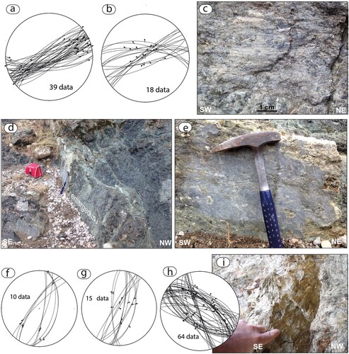
The NE-striking faults are characterized by two superposed generations of kinematic indicators ((a–e)): the first indicate strike- to oblique-slip left-lateral movement, while the second displays normal to left- or right-lateral slightly oblique-slip movements. The age of activity is constrained by the age of the most recent units affected by the deformation, that are represented by the Chiusdino Fm. Thus, the NE-striking faulting occurred during the Late Miocene and Gelasian time interval, although an older age cannot be excluded.
A kinematic framework similar to the NE-striking faults is also described for the NNE-striking structures ((f, g)). However, the NW-trending faults are mainly normal ((h, i)). Their age is considered to be between Pliocene and Gelasian, considering that the NW-striking faults delimit the Pliocene tectonic depression and crosscut the Chiusdino Fm.
The geometrical relationships among the different fault systems and Miocene shear zones are shown in the geological sections reported in Sheet 2, where the geometrical setting of the tectonic units, Miocene shear zones and Zanclean-Gelasian faults have been also constrained integrating borehole data (CitationLazzarotto & Mazzanti, 1978).
5. Discussion and conclusions
These are focussed on two different topics: the Tertiary evolution and the CO2 storage perspective.
As regards the Tertiary record, the tectonic pile built up during the Northern Apennines orogenesis was dismantled during Miocene-Pleistocene extension by multiple faulting active in extensional setting, which brought to regional uplift and exhumation of ophiolitic rocks (CitationLiotta & Brogi, 2020 and reference therein). The activity of the NE-, NNE- and NW-striking faults is coeval and encompassed between Zanclean and Gelasian times. This implies they were active in the same regional stress field. Considering the almost orthogonal relationships between NE- and NW-striking faults and their kinematics, the NE-trending structures played the role of transfer faults (CitationGibbs, 1984), controlling the development of the Pomarance Basin. These faults have strike- to oblique-slip kinematics during their earlier activity. From our observations, we conclude that the NE-striking faults concentrated nearby the Montecastelli Pisano village crossing the study area, define a sub-vertical brittle shear zone, up to 5 km wide, formed by sub-parallel and anastomozed fault segments, interpreted as a transfer zone associated to the extensional tectonics affecting the area.
The second kinematic event documented for the NE-trending faults is mainly normal, similarly to the one characterizing the NW-striking faults. This can be explained taking in account the recent regional uplift (CitationDallmeyer & Liotta, 1998) by which all the already existing structures played the role of normal faults, independently by their orientation. This interpretation can also explain why the NW-trending faults do not show evidence of different kinematics. The activity of the NE-striking faults, however, overcomes the other fault systems.
The Montecastelli Ophiolite Complex represents a typical section of slow-spreading oceanic mantle with dunite channels formed by migration of mantle melts at the spreading ridge, and gabbro dikes cutting all the previous structure feeding larger laccoliths emplaced in the main serpentinized spinel harzburgite body.
From a CO2 storage perspective, this study confirms that only serpentinized dunite is strongly reactive to CO2 at ambient conditions, spontaneously sequestering CO2 through the formation of hydromagnesite, nesquehonite and Mg-Fe layered double hydroxides, because of the presence of brucite, which instead was not produced during the serpentinization of the harzburgitic portions. Mapping of the Montecastelli Ophiolite Complex also provided a background for evaluating the distribution, and abundance, of different ultramafic lithologies, necessary for the estimation of the CO2 storage potential through mineral carbonation in the area.
Software
The geological map was compiled integrating scanning hand drafts and digital data collected by FIELDMOVE by Petroleum Experts Limited, a free software running on iPad (https://apps.apple.com/us/app/fieldmove/id968405777). Both sources were homogenized in GIS environment by Arc Map GIS Application, in order to add the topographic maps and to geo-reference the geological maps. The editing work was finally concluded using the Adobe Illustrator® graphics package.
Supplemental Material
Download PDF (49.2 MB)Supplemental Material
Download PDF (9.4 MB)Acknowledgements
A large part of this fieldwork was carried out by Marco Meccheri, prematurely passed away, during a joint project between the Department of Physics, Earth and Environmental Sciences of the University of Siena and Magma Energy-Italy s.p.a (2011-2012). On that collaboration, Luca Maria Foresi contributed by providing micropaleontological analyses of the Neogene deposits. A.B. and D.L. did their best to report accurately Marco’s database, and are confident to have disclosed his thoughts on the structure of the Montecastelli area: our efforts are dedicated to his memory. The geological maps (sheet 1 and sheet 2) were edited by GIS&GRAFICA https://gisgrafica.it/. We appreciated the editorial work of Mike Smith and Monica Pondrelli. We are indebted to the reviewers Mike Shand, Emmanuel Corsini and Gianreto Manatschal for their constructive comments and careful revision.
Disclosure statement
No potential conflict of interest was reported by the author(s).
Additional information
Funding
References
- Barchi, M. R. (2010). The Neogene-Quaternary evolution of the Northern Apennines: Crustal structure, style of deformation and seismicity. In M. Beltrando, A. Peccerillo, M. Mattei, S. Conticelli, & C. Doglioni (Eds.), The neogene-quaternary evolution of the northern Apennines: Crustal structure, style of deformation, Seismicity, 36, Journ. Virt. Explorer (pp. 1–25).
- Bianco, C., Godard, G., Halton, A., Brogi, A., Liotta, D., & Caggianelli, A. (2019). The lawsonite-glaucophane blueschists of Elba Island (Italy). Lithos, 348–349, 105198. https://doi.org/10.1016/j.lithos.2019.105198
- Bonini, M., & Moratti, G. (1995). Evoluzione tettonica del bacino neogenico di Radicondoli-Volterra (Toscana meridionale). Bollettino della Società geologica italiana, 114, 549–573.
- Boschi, C., Bedini, F., Baneschi, I., Rielli, A., Baumgartner, L., Perchiazzi, N., Ulyanov, A., Zanchetta, G., & Dini, A. (2020). Spontaneous serpentine carbonation controlled by underground dynamic microclimate at the montecastelli copper mine, Italy. Minerals, 10(1), 1. https://doi.org/10.3390/min10010001
- Boschi, C., Dini, A., Baneschi, I., Bedini, F., Perchiazzi, N., & Cavallo, A. (2017). Brucite-driven CO2 uptake in serpentinized dunites (Ligurian Ophiolites, Montecastelli, Tuscany). Lithos, 288, 264–281. https://doi.org/10.1016/j.lithos.2017.07.005
- Boschi, C., Dini, A., Dallai, L., Ruggieri, G., & Gianelli, G. (2009). Enhanced CO2-mineral sequestration by cyclic hydraulic fracturing and Si-rich fluid infiltration into serpentinites at Malentrata (Tuscany, Italy). Chemical Geology, 209–226. https://doi.org/10.1016/j.chemgeo.2009.03.016
- Bossio, A., Costantini, A., Lazzarotto, A., Liotta, D., Mazzanti, R., Mazzei, R., Salvatorini, G., & Sandrelli, F. (1993). Rassegna delle conoscenze sulla stratigrafia del neoautoctono toscano. Memorie della Societa Geologica Italiana, 49, 17–98.
- Brogi, A. (2004). Miocene low-angle detachments and upper crust megaboudinage in the Mt. Amiata geothermal area (Northern Apennines, Italy). Geodinamica Acta, 17(2004), 375–387.
- Brogi, A. (2011). Bowl-shaped basin related to low-angle detachment during continental extension: The case of the controversial Neogene Siena Basin (central Italy, Northern Apennines). Tectonophysics, 499(1–4), 54–76. https://doi.org/10.1016/j.tecto.2010.12.005
- Brogi, A. (2020). Late evolution of the inner northern Apennines from the structure of the Monti del Chianti-Monte Cetona ridge (Tuscany, Italy). Journal of Structural Geology, 141, 104205. https://doi.org/10.1016/j.jsg.2020.104205
- Brogi, A., & Giorgetti, G. (2012). Tectono-metamorphic evolution of the siliciclastic units in the Middle Tuscan Range (inner Northern Apennines): Mg–carpholite bearing quartz veins related to syn-metamorphic syn-orogenic foliation. Tectonophysics, 526–529(2012), 167–184. https://doi.org/10.1016/j.tecto.2011.09.015
- Brogi, A., Lazzarotto, A., Liotta, D., & Ranalli, G. (2005). Crustal structures in the geothermal areas of southern Tuscany (Italy): Insights from the CROP 18 deep seismic reflection lines. Journal of Volcanology and Geothermal Research, 148(1–2), 60–80. https://doi.org/10.1016/j.jvolgeores.2005.03.014
- Brogi, A., & Liotta, D. (2008). Highly extended terrains, lateral segmentation of the substratum, and basin development: The middle-late Miocene Radicondoli Basin (inner northern Apennines, Italy). Tectonics, 27(5), TC5002. https://doi.org/10.1029/2007TC002188
- Brunet, C., Monié, P., Jolivet, L., & Cadet, J. P. (2000). Migration of compression and extension in the Tyrrhenian Sea, insights from 40Ar/39Ar ages on micas along a transect from Corsica to Tuscany. Tectonophysics, 321(1), 127–155. https://doi.org/10.1016/S0040-1951(00)00067-6
- Calcagnile, G., & Panza, GF,. (1981). The main characteristics of the lithosphere-asthenosphere system in Italy and surrounding regions. Pure and Applied Geophysics PAGEOPH, 119(4), 865–879. https://doi.org/10.1007/BF01131263
- Carmignani, L., Decandia, F. A., Disperati, L., Fantozzi, P. L., Lazzarotto, A., Liotta, D., & Meccheri, M. (1994). Tertiary extensional tectonics in Tuscany (northern Apennines, Italy). Tectonophysics, 238(1–4), 295–315. https://doi.org/10.1016/0040-1951(94)90061-2
- Cassinis, R., Scarascia, S., & Lozej, A. (2003). The deep crustal structure of Italy and surroundings areas from seismic refraction data. A new synthesis. Bollettino della Società geologica italiana, 122, 365–376.
- Dallmeyer, R. D., & Liotta, D. (1998). Extension, uplift of rocks and cooling ages in thinned crustal provinces: The Larderello geothermal area (inner Northern Apennines,Italy). Geological Magazine, 135(2), 193–202. https://doi.org/10.1017/S0016756898008309
- Della Vedova, B., Bellani, S., Pellis, G., & Squarci, P. (2001). Deep temperatures and surface heat flow distribution. In G. B. Vai, & I. P. Martini (Eds.), Anatomy of an orogen: The Apennines and adjacent Mediterranean Basins (pp. 65–76). Kluwer Academic Publishers.
- Dini, A., & Boschi, C. (2017). I giacimenti cupriferi delle ofioliti toscane: geologia ed ipotesi genetiche. Rivista Mineralogica Italiana, 21, 84–101.
- Dini, A., Westerman, D. S., Innocenti, F., & Rocchi, S. (2008). Magma emplacement in a transfer zone: The Miocene mafic Orano dyke swarm of Elba Island, Tuscany, Italy. In K. Thomson, & N. Petford (Eds.), Structure and emplacement of high-level Mag- matic systems (Vol. 302, pp. 131–148). Geological Society, London, Special Publications.
- Di Stefano, R., Bianchi, I., Ciaccio, M. G., Carrara, G., & Kissling, E. (2011). Three-dimensional Moho topography in Italy: New constraints from receiver functions and controlled source seismology. Geochemistry, Geophysics, Geosystems, 12(9). http://doi.org/10.1029/2011GC003649
- Gibbs, A. D. (1984). Structural evolution of extensional basin margins. Journal of the Geological Society, 141(4), 609–620. https://doi.org/10.1144/gsjgs.141.4.0609
- Lazzarotto, A., & Mazzanti, R. (1978). Geologia dell’Alta Val di Cecina. Bollettino della Società geologica italiana, 95, 1365–1487.
- Lazzarotto, A., Sandrelli, F., Foresi, L. M., Mazzei, R., Salvatorini, G., Cornamusini, G., & Pascucci, V. (2002). Note illustrative della Carta Geologica d'Italia alla scala 1.50000: foglio 295 - Pomarance. Servizio Geologico Nazionale, Roma, 238.
- Liotta, D. (1991). The Arbia-Val Marecchia line, northern Apennines. Eclogae Geologicae Helvetiae, 84, 413–430.
- Liotta, D., & Brogi, A. (2020). Pliocene-Quaternary fault kinematics in the Larderello geothermal area (Italy): Insights for the interpretation of the present stress field. Geothermics, 83, 101714. https://doi.org/10.1016/j.geothermics.2019.101714
- Liotta, D., Brogi, A., Meccheri, M., Dini, A., Bianco, C., & Ruggieri, G. (2015). Coexistence of low-angle normal and high-angle strike- to oblique-slip faults during Late Miocene mineralization in eastern Elba Island (Italy). Tectonophysics, 660, 17–34. https://doi.org/10.1016/j.tecto.2015.06.025
- Liotta, D., Brogi, A., Ruggieri, G., & Zucchi, M. (2021). Fossil vs. active geothermal systems: A field and laboratory method to disclose the relationships between geothermal fluid flow and geological structures at depth. Energies, 14(4), 933. https://doi.org/10.3390/en14040933
- Martini, I., Ambrosetti, E., Brogi, A., Aldinucci, M., Zwaan, F., & Sandrelli, F. (2021). Polyphase extensional basins: Interplay between tectonics and sedimentation in the Neogene Siena-Radicofani Basin (northern Apennines, Italy). International Journal of Earth Sciences, 110(5), 1729–1751. https://doi.org/10.1007/s00531-021-02038-4
- Martini, I. P., & Sagri, M. (1993). Tectono-sedimentary characteristics of late Miocene-Quaternary extensional basins of the northern Apennines, Italy. Earth-Science Reviews, 34(3), 197–233. https://doi.org/10.1016/0012-8252(93)90034-5
- Mazzanti, R. (1966). Geologia della zona di Monteverdi Marittimo-Canneto. Atti della Società Toscana di Scienze Naturali - Memorie Serie A, 73, 467–490.
- Molli, G. (2008). Northern Apennine-Corsica orogenic system: An updated overview. Geological Society, London, Special Publications, 298(1), 413–442. https://doi.org/10.1144/SP298.19
- Montanini, A., Tribuzio, R., & Thirlwall, M. (2012). Garnet clinopyroxenite layers from the mantle sequences of the Northern Apennine ophiolites (Italy): evidence for recycling of crustal material. Earth and Planetary Science Letters, 351–352, 171–181. https://doi.org/10.1016/j.epsl.2012.07.033
- Pandeli, E., Bertini, G., & Castellucci, P. (1991). The tectonic wedges complex of the Larderello area (southern Tuscany). Bollettino della Società geologica italiana, 110, 621–629.
- Piccardo, G. B., Padovano, M., & Guarnieri, L. (2014). The Ligurian Tethys: Mantle processes and geodynamics. Earth-Science Reviews, 138, 409–434. https://doi.org/10.1016/j.earscirev.2014.07.002
- Rielli, A., Boschi, C., & Dini, A. (2022). Tectonically driven carbonation of serpentinite by mantle CO2: Genesis of the Castiglioncello magnesite deposit in the Ligurian ophiolite of central Tuscany (Italy). Ore Geology Reviews, 149, 105022. https://doi.org/10.1016/j.oregeorev.2022.105022
- Rielli, A., Dini, A., Baneschi, I., Trumpy, E., Bicocchi, G., Orlando, A., Ruggeri, G., Montegrossi, G., & Boschi, C. (2021). Carbon storage in ultramafic rocks: Innovative approaches learned from natural systems. In OMC Med Energy Conference and Exhibition. OnePetro.
- Rossetti, F., Faccenna, C., Jolivet, L., Goffé, B., & Funiciello, R. (2002). Structural signature and exhumation P-T-t paths of the blueschist units exposed in the interior of the Northern Apennine chain, tectonic implications. Bollettino della Società geologica italiana, 1, 829–842.
- Serri, G., Innocenti, F., & Manetti, P. (1993). Geochemical and petrological evidence of the subduction of delaminated Adriatic continental lithosphere in the genesis of the Neogene–Quaternary magmatism of central Italy. Tectonophysics, 223(1-2), 117–147. https://doi.org/10.1016/0040-1951(93)90161-C
- Signorini, R. (1966). I terreni neogenici del Foglio Siena. Bollettino della Società geologica italiana, 85, 639–654.
- Signorini, R., Centamore, E., & Conato, V. (1963). La formazione di Lanciaia nella Val di Cecina. Bollettino del Servizio Geologico d’Italia, 84, 83–100.
- Theye, T., Reinhardt, J., Goffé, B., Jolivet, L., & Brunet, C. (1997). Ferro- and magnesiocarpholite from the Monte Argentario (Italy): First evidence for high-pressure metamorphism of the metasedimentary Verrucano sequence, and significance for P-T path reconstruction. European Journal of Mineralogy, 9(4), 859–874. https://doi.org/10.1127/ejm/9/4/0859