
ABSTRACT
The Southern Apennines consist of a Cenozoic to Quaternary fold and thrust belt characterized by a complex structural architecture. In the axial portion of the chain, corresponding to the Agri Valley, folds and faults with multiple styles formed during the progressive emplacement of various tectonic units, derived from different paleodomains. In the available geological maps, the geometry of these tectonic structures is often hindered by scarce cartographic detail due to the use of basic stratigraphic subdivisions. Therefore, at the aim to better define these structures and contextually update the outcropping stratigraphic units, we realized a detailed geological map, which take into consideration not only the formation as basic stratigraphic units, but also finer subdivisions such as members or beds. Using this approach, we improved the stratigraphy of the area, we recognized new geological units and, eventually, we reconstructed the structural setting, and the tectonic evolution of the Agri Valley in detail.
Policy highlights
The detailed geological map is useful for planning of infrastructures and buildings in the area;
Detailed distribution of lithological subdivision can be used for more accurate environmental studies;
Detailed mapping allows a better estimate of the hydrogeological properties of the outcropping units and improves planning for water exploitation.
1. Introduction
The axial zone of the Southern Apennines shows a complex structural arrangement, resulting from the superposition of contractional, strike-slip and extensional tectonic structures, which are often difficult to unravel (CitationCello et al., 2000; CitationMazzoli et al., 2001; CitationOlita et al., 2023). Recently, CitationProsser et al. (2021), have stressed on the importance of using updated geological maps, showing detailed stratigraphic subdivisions, for unravelling the geometry of the tectonic structures in such structurally complex terrains. The authors successfully applied this method to a sector of the Agri Valley in the Southern Apennines. Encouraged by the good-quality preliminary results and aware that other authors came to the same conclusions using the same approach in different areas (i.e. CitationZuccari et al., 2021), the authors decided to extend the study to the entire left side of the Agri Valley (a, b). This choice was essentially driven by the occurrence in this area of a great amount of hydrocarbon and freshwater reserves capable to provide tens of thousands of barrels of oil per day and millions of m3 of water (CitationColella, 2003). Due to the large exploitation of these natural resources, we believe that the Agri Valley represent a critical area, where benefiting from an accurate mapping and a precise reconstruction of the outcropping geology is essential, for example, to prevent or deal with possible environmental issues.
Figure 1. (A) Tectonic sketch map of the Southern Apennines and the Agri Valley; (B) Area of the Agri Valley covered by the geological map (red line).
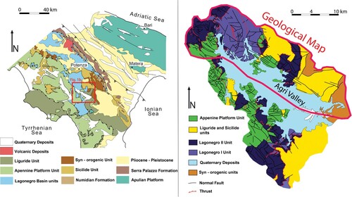
Geological maps encompassing the Agri Valley were released since the beginning of the last century (CitationBaldacci et al., 1908; CitationBaldacci & Sabatini, 1908), with significant improvements during the ‘70s, when the Geological Map of Italy at the 1:100.000 scale was published by the Italian Geological Survey. In particular, the Agri Valley was included within the Sheet 199 ‘Potenza’, Sheet 210 ‘Lauria’ and Sheet 211 ‘S. Arcangelo’ (Ogniben, Citation1969a, Citation1969b; Scandone, Citation1971), where the main tectonic units forming this sector of the Apennine chain were defined and mapped for the first time. A particular focus on the Agri Valley was successively provided by CitationCarbone et al. (1991) at the 1:50000 scale, who introduced new details in the tectono-stratigraphic organization and in the mapping of the geological structures. The last update was provided by the realization of the new Geological Map of Italy at the 1:50000 scale by the Italian Institute for Environmental Protection and Research (ISPRA). The Agri Valley was included in the sheets 489 ‘Marsico Nuovo’ (Servizio Geologico d'Italia, Citation2012), 505 ‘Moliterno’ (Servizio Geologico d'Italia, Citation2014a), 506 ‘S. Arcangelo’ (Servizio Geologico d'Italia, Citation2005), and 521 ‘Lauria’ (Servizio Geologico d'Italia, Citation2014b). Further geological maps for the NW sector of the study area have been published at the 1:25.000 scale by CitationBucci et al. (2012, Citation2020).
Despite the progressive updates, all the cited geological maps are based on stratigraphic schemes that mostly provide a formational rank level of detail. However, a series of studies focussing on detailed stratigraphic analyses of the successions exposed in the Agri Valley showed that a higher level of stratigraphic resolution, including members and marker intervals, is possible (CitationAmodeo, 1999; CitationGiordano et al., 2011; CitationRigo et al., 2012) and these lower rank units are still suitable for mapping at a 1:30000 scale.
The advantages of producing such a detailed map are manifold. It shows a more refined distribution of the outcropping stratigraphic units, which have been defined mostly at member level. Consequently, the displacement produced by faults, especially when cutting through a single formation, and fold geometry is outlined with a markedly better resolution with respect to previous maps. More in general, the map represents a reliable tool for the sustainable exploitation of natural resources, environmental studies, and research.
2. Geological setting
The high Agri Valley is located in a crucial area of the Southern Apennine fold and thrust belt, corresponding to its axial portion (CitationMenardi-Noguera & Rea, 2000) (a, b). It consists of a tectonically controlled depression filled by a thick pile of quaternary deposits (CitationGiano, 2011; CitationGiano et al., 2000). The pre-Quaternary bedrock, well exposed along both sides of the valley, includes some of the older formations in Southern Italy. These make up the deeper structural levels of the fold and thrust belt, which has been drilled by a series of boreholes for hydrocarbon exploration (CitationShiner et al., 2004). Emplacement of the tectonic units is the result of different tectonic phases that involved the Tethyan realm and the northern margin of the African plate from the Cenozoic to the Pleistocene times (CitationPatacca & Scandone, 2007). Exhumation mainly took place during the Upper Pliocene – Pleistocene and was initially driven by the development of low-angle normal faults (CitationBucci et al., 2014; CitationMazzoli et al., 2008). Integrated geological and geophysical studies carried out during the last decades, particularly prompted by hydrocarbon exploration, strongly contributed to the knowledge and the understanding of the geological setting of the area (CitationMazzoli et al., 2001; CitationShiner et al., 2004). These studies allowed dividing the stacked allochthonous nappes and the quaternary valley infill into different stratigraphic units (CitationBucci et al., 2012, Citation2020; CitationGiano, 2011, Citation2016; CitationZembo, 2010).
The tectono-stratigraphic organization of the Agri Valley pre-Quaternary bedrock, which is representative of the axial portion of the entire Southern Apennine fold and thrust belt, from the geometrically upper to the lower tectonic unit, is summarized as it follows ().
Figure 2. Tectono-stratigraphic scheme of the units showed in the geological map. Inset on the upper right side of the figure shows finer stratigraphic details of the successions included in the red boxes.
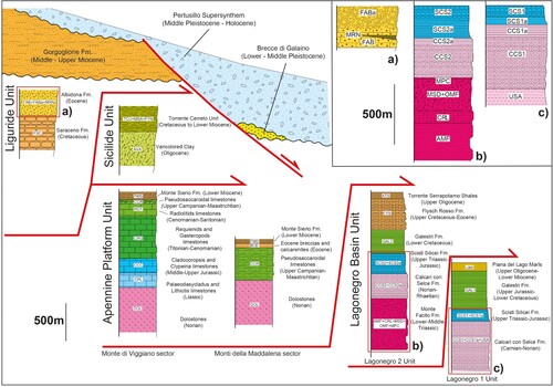
The Liguride Unit, represents the highest tectonic unit. It consists of a strongly deformed Meso-Cenozoic succession pertaining to the Alpine Tethys realm, originally deposited above an oceanic crust (CitationBonardi et al., 1988). The succession consists of strongly deformed metamorphic and non-metamorphic rocks, followed upward by deep – water turbidites (CitationCavalcante et al., 2012; CitationProsser et al., 2021).
The Sicilide Unit derives from a Meso-Cenozoic succession deposited in a basin located between the Tethyan domain and the northern African paleomargin (CitationLentini, 1979; CitationOgniben, 1969b; CitationPatacca & Scandone, 2007). This unit mainly consists of basinal clays and turbidites.
The Apennine Platform Unit consists of a Meso-Cenozoic shallow water carbonate succession originally deposited at the northern margin of the African plate (CitationD’Argenio et al., 1973; CitationPatacca & Scandone, 2007; CitationScandone & Bonardi, 1968). Shallow water carbonates are followed upwards by Miocene slope to basin siliciclastic deposits, testifying the dismissing and drowning of the carbonate platform.
The Lagonegro II Unit (CitationScandone, 1967, Citation1972) consists of a Meso-Cenozoic succession deposited in the proximal sector of the Lagonegro Basin, E of the Apennine Platform. The succession records the progressive opening and deepening of the basin and its transition from shallow to deep-water conditions, below the CCD (CitationMiconnet, 1988).
The Lagonegro I Unit (CitationScandone, 1967, Citation1972) consists of a Meso-Cenozoic succession deposited in the axial sector of the Lagonegro Basin. The succession shares similar characteristics with the Lagonegro II Unit; however, it lacks the shallow water interval at the base.
The youngest formation of the substratum is represented by base of slope to basinal siliciclastic turbidites of the Miocene Gorgoglione Formation, consisting of syn-orogenic thrust-top deposits lying unconformably on the aforementioned tectonic units (CitationBoiano, 1997; CitationSelli, 1962).
Finally, the quaternary infill of the Agri Valley consists of a thick package of fluvial plain and alluvial fan deposits, fed both longitudinally and transversally to the valley, deposited on the Meso-Cenozoic bedrock.
All these units and the related formations will be described in detail in the next sections.
3. Methods
The geological map covers an area of about 350 Km2 () between Pergola and Montemurro (Main Map). It has been constructed by using the topographic map of the Basilicata Region, at a 1:25:000 scale (https://rsdi.regione.basilicata.it). Fieldwork has been carried out at a 1:10.000 scale; more detailed mapping at 1:5.000 scale has been done in sectors characterized by higher tectonic and/or stratigraphic complexity. During fieldwork, 3.118 outcrop data have been collected and georeferenced, and 3.014 attitudes of bedding planes have been measured. Attitude data have been selected using a GIS environment in structurally consistent sub-areas and processed with the Stereonet software by RWA Allmendinger. The original data are openly available in a public repository. The geological map has been finally rendered at 1:30.000 scale, using as base map the topographic map of the Basilicata Region, at a 1:25.000 scale.
4. Stratigraphy of the north-eastern side of the high Agri Valley
The stratigraphic organization proposed in Main Map is summarized in the tectono-stratigraphic scheme of . The tectonic units are indicated by a short acronym made by two letters or a letter and a number. The stratigraphic units are indicated by acronyms made by a combination of two, three or four letters and numbers. The occurrence of a subscript letter denotes a member, which has been mapped due to significant differences with respect to the general characteristics of the considered formation. A short description of the stratigraphy of the different tectonic units, from the geometrically higher to the lower, is here provided based on new field data and the previous literature. Additional details can be found in the legend accompanying the Main Map. New findings are emphasized.
4.1. Pre-quaternary substratum
4.1.1. Liguride unit (LI)
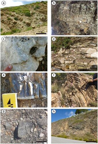
Represents the remnant of the Ligurian accretionary prism which consists of strongly deformed Meso-Cenozoic rocks, originally deposited above the Alpine Tethys Ocean (CitationBonardi et al., 1988; CitationCavalcante et al., 2012; CitationProsser et al., 2021) (). In the Agri Valley only the youngest stratigraphic units, represented by the Saraceno and Albidona formations, are present. The Saraceno Formation (FSC) consists of alternating clays, calcilutites and calcarenites. Based on CitationTorricelli and Amore (2003) the age ranges from Middle to Upper Cretaceous. According to CitationBaruffini et al. (2000) and CitationProsser et al. (2021), the Albidona Formation has been subdivided into two members, FAB and FABa, the former containing marly horizons (MRN). This new stratigraphic scheme allowed to extend FAB to larger areas with respect to the existing geological maps (a great portion of the Albidona Formation deposits occurring in the study area have erroneously been ascribed to the Gorgoglione Formation, see CitationProsser et al., 2021), by mapping specific stratigraphic horizons. FAB mainly consists of alternating clays, marls and sandstones, whereas coarse-grained sandstones and conglomerates dominate in FABa (a). The age of the formation is still matter of debate (CitationBaruffini et al., 2000; CitationBonardi et al., 1985); however, the stratigraphy of the Albidona succession exposed at Monte dell’Agresto, which is representative of the entire formation in the study area, has been recently revised, providing an Eocene Age (CitationProsser et al., 2021).
Figure 3. Examples of the mapped stratigraphic units. (A) Liguride Unit: regularly bedded sandstones and clays of the Albidona Formation (FAB) cropping out at Monte dell’Agresto. The fragmented whitish rocks pertain to a cm-thick marly horizon; (B) Sicilide Unit: thinly laminated marls pertaining to the Varicolored Clay (AVA) cropping out north of the Monte di Viggiano; (C) Apennine Platform Unit: rudist (caprinids) fragments-rich limestones recognized at Monte di Viggiano pertaining to the Radiolitids Limestones (RDT); (D) L2 Unit: cm-thick, well-bedded red sandstones pertaining to the Monte Facito Sandstones member (AMF) of the Monte Facito Formation, north of the Cognone locality; (E) L1 Unit: dm – thick grey calcilutite layer showing a 1.5 cm thick bioturbated whitish interval at the base. Sorgente Acero member (USA), south of Monte San Nicola ridge; (F) L1 Unit: cm – thick, well bedded cherts pertaining to the upper member of the Scisti Silicei Formation (SCS1) in the Monte Farneta locality; (G) Syn – orogenic Unit: conglomerates of the Gorgoglione Formation (FGO) east of Montemurro village; (H) Quaternary basin infill: scree deposits pertaining to the Brecce di Galaino Unit (GALB) near Marsicovetere.
4.1.2. Sicilide unit (SI)
The Sicilide Unit consists of deep-water sediments originally deposited in a basin located between the Tethyan domain and the northern African paleomargin (CitationLentini, 1979; CitationOgniben, 1969b; CitationPatacca & Scandone, 2007) and includes two main formations (). The first formation, the Torrente Cerreto Unit (TCU) (CitationLentini, 1979), is a chaotically-organized unit consisting of a varicoloured shaly matrix, containing isolated blocks of white marls and quartzarenites derived respectively from the Monte Sant’Arcangelo Unit (MSA) and the Numidian Flysch (FYN). We interpret this unit as a mass transport deposit (MTDs) (CitationFesta et al., 2022 and references therein). The second formation is represented by the Varicoloured Clay (AVA) (Oligocene; CitationBucci et al., 2012), consisting of varicoloured shales alternating with cm to m-thick calcarenites and sandstones, microconglomerates and 10 m thick layers of whitish marls (AVA1) (b). Microconglomerates are made up of clasts of phyllites and platform limestones.
4.1.3. Apennine platform unit (AP)
Consists of Triassic to Eocene Meso-Cenozoic shallow water carbonates, pertaining to the Monti della Maddalena Unit, originally deposited at the northern margin of the Apennine Platform (CitationD’Argenio et al., 1973; CitationPatacca & Scandone, 2007; CitationPescatore et al., 1999; CitationScandone, 1971; CitationScandone & Bonardi, 1968) (). Oligocene deposits are commonly not preserved, while Miocene siliciclastic successions unconformably cover the carbonate succession.
The succession starts with Upper Triassic inner platform dolostones (DOL) followed upward by the Palaeodasycladus and Lithiotis Limestones (CPL) (Lower Jurassic) and Cladocoropsis and Clypeina Limestones (CCC) (Middle-Upper Jurassic). The Jurassic units show inner platform to high energy (oolithic sand shoals) open marine facies.
Cretaceous units consist of Requienids and Gastropods Limestones (CRG) (Lower Cretaceous), pertaining to a carbonate platform s.s., the Radiolitids Limestones (RDT) (Upper Cretaceous) related to a margin to slope environment (CitationCestari & Laviano, 2012) (c), and the Pseudosaccaroidal Limestones (CCR) (Upper Cretaceous) (CitationMarsella & Pappone, 1987), deposited in a carbonate slope environment.
Eocene deposits are represented by the Eocene Breccias and Calcarenites (BCE) which, similarly to the previous unit, are related to a carbonate slope environment.
The succession ends with the calciclastic to siliciclastic, base of slope to basin, deposits of the Monte Sierio Formation (FMS) (Lower Miocene) (CitationCastellano & Sgrosso, 1996; CitationPalladino et al., 2008).
Upper Triassic, Upper Jurassic, Upper Cretaceous, Paleocene and Oligocene hiatuses are well documented by the unconformities recognized at the base of these formations (CitationMarsella & Pappone, 1987; CitationPescatore et al., 1999; CitationScandone & Bonardi, 1968).
4.1.4. Lagonegro 2 unit (L2)
Includes all the Meso-Cenozoic units deposited in the proximal sectors of the Lagonegro Basin (CitationScandone, 1967, Citation1972) (). The succession records the progressive opening and deepening of the basin and its transition from shallow to deep-water conditions (CitationMiconnet, 1988).
The oldest unit is represented by the Monte Facito Formation (Middle Triassic) (CitationCiarapica & Passeri, 2000; CitationScandone, 1967; CitationWood, 1981), which has been divided for the first time into four members (Main Map). The unit lacks its original stratigraphic base; therefore, it cannot be considered as a formally designed formation. The oldest member is represented by the Monte Facito Sandstones (AMF) (CitationPanzanelli Fratoni, 1991) (d) followed upward by the reefal Cerchiara Limestones (CRL) (CitationCiarapica & Passeri, 2000; CitationGuido et al., 2021; CitationPalladino, 2015). The Sedimentary Mélange member (MSD), consists of a shaly-cherty succession containing resedimented material, including Carbonate Olistoliths (OMF), provided by the older members (CitationMarsella et al., 1993; CitationPalladino, 2015; CitationPalladino et al., 2019). The Petina Chiana member (MPC) represents the transition toward the uppermost formation (CitationPanzanelli Fratoni, 1991).
The Calcari con Selce Formation has been divided into two members (CitationBertinelli et al., 2005; CitationGiordano et al., 2011), which have been mapped for the first time in the study area. The lower member, Calcari con Selce 2 (CCS2) (Carnian – Norian), consists of thinly – bedded pelagic cherty limestones, with local secondary dolomitization. A green clay-radiolaritic interval, related to the Carnian Pluvial Event (CitationRigo et al., 2007), occurs near the base in the northwestern sector of the study area. The upper member, called as Transitional Interval 2 (CCS2a) (Upper Norian – Lower Rhaetian), is bounded at the base by a typical horizon of red shale, and consists of alternating shales, marls, calcarenites and cherty limestones (CitationBertinelli et al., 2005; CitationGiordano et al., 2011).
The Scisti Silicei Formation consists of two members, identified for the first time in the study area. The lower Scisti Silicei 2 (SCS2a) (Upper Triassic – Lower Jurassic) consists of shales alternating with marly limestone and isolated radiolarites. The Scisti Silicei 2 (SCS2) (Jurassic) is the younger member, corresponding to the Chiatamone member defined by CitationAmodeo (1999).
The Galestri 2 (GAL2) (Lower Cretaceous) and the Flysch Rosso (FYR) formations (Upper Cretaceous – Eocene) have been mapped following the existing literature (CitationPatacca & Scandone, 2007). The Torrente Serrapotamo Shales (ATS) (Upper Oligocene) represents the youngest formation of the L2 Unit (Geological sheet 505 ‘Moliterno’, 2014). It consists of prevailing shales, micaceous arenites, turbiditic limestones and conglomerates. In the study area, FYR and ATS do not show clear stratigraphic boundaries with the underlying formations but rather sharp low-angle tectonic contacts.
4.1.5. Lagonegro 1 unit (L1)
The L1 Unit (CitationScandone, 1967, Citation1972) encompasses the Meso-Cenozoic formations deposited in the axial sectors of the Lagonegro Basin (). The succession shares similar characteristics with the L2 Unit (e,f); however, it lacks the shallow water interval at the base, represented by the Middle Triassic AMF and CRL.
The succession starts with alternating brownish shales, limestones and marly – limestones of the Sorgente Acero Member (USA) of the Calcari con Selce 1 Formation (CitationBucci et al., 2020; CitationPatacca & Scandone, 2007). It continues upward with the Calcari con Selce 1 and the Transitional Interval 1 (CCS1, CCS1a), as well as the Scisti Silicei 1 (SCS1, SCS1a) and the Galestri 1 (GAL1) formations. All these units show distal characteristics with respect to the corresponding units described for the L2 Unit. The succession ends with a new stratigraphic unit informally introduced for the first time in this area, named as Piana del Lago Marls (UMI). The formation consists of alternating shales, marls and sandstones. The age is Upper Oligocene – Lower Miocene, as documented by the occurrence of Miogyspina sp. and Miogypsinoides. sp.
4.1.6. Syn – orogenic unit (SY)
They are represented by the Gorgoglione Formation (FGO) (g), which consists of rhythmically alternating conglomerates, turbidite sandstones and clays, organized in thinning and thickening upwards sequences. In the study area this formation lies unconformably above the Albidona Formation. The depositional environment ranges from slope, base of slope to basin. The age is Middle-Upper Miocene (CitationBoiano, 1997; CitationGiannandrea et al., 2016; CitationSelli, 1962).
4.2. Quaternary basin infill (QU)
Quaternary deposits, representing the infill of the Agri Valley, consist of unconsolidated and coarse – to fine-grained continental deposits, fed both longitudinally and transversally to the Agri Valley, ranging in time from Lower Pleistocene to present-day, whose stratigraphy has been reconstructed in the 489 ‘Marsico Nuovo’ and 505 ‘Moliterno’ sheets (Servizio Geologico d'Italia, Citation2012, Citation2014a).
The oldest unit is represented by the Lower to Middle Pleistocene Brecce di Galaino Unit (GALB, GALM) composed by clast – to matrix-supported coarse-grained breccias with interbedded palaeosoils (CitationGiano, 2011) (h).
The Pertusillo Supersynthem encompasses Middle Pleistocene to Holocene fluvial and lacustrine successions. From bottom to top, it includes the Middle Pleistocene Grumento Synthem (GRUG, GRUM, GRUF), the Middle to Upper Pleistocene Bosco dell’Aspro Synthem (VDAG, VDAF, SARG, SARF), and the Holocene Bosco San Lorenzo Synthem (SLOG, SLOM).
Recent deposits are represented by Upper Holocene fluvial terraces and present-day floodplain deposits (FA) and by palustrine successions (DLG, DLF). Recent and massive matrix-supported scree deposits (DT) are distributed in the piedmont area. Eluvial and colluvial (EC) successions together with landslide (CF) deposits occur along the slopes (CitationBentivenga et al., 2012, Citation2022; CitationGueguen et al., 2015).
5. The structural organization of the north-eastern side of the high Agri Valley
The structural setting of the north-eastern side of the high Agri Valley derives from different tectonic phases occurred since the Oligocene (CitationBucci et al., 2014, Citation2020; CitationMazzoli et al., 2001). As a result of our detailed mapping (Main Map), the whole area has been divided, from NW to SE, into four sectors delimited by three NE-trending oriented fault zones (). Each sector shows peculiar differences in structural styles and stratigraphic organization. We describe the main features of each sector and the bounding tectonic structures in the next sections.
Figure 4. Structural sketch map of the northeastern side of the Agri Valley showing the outcropping tectonic units and the main structures recognized in the area. Three main structures, represented by the Agri, Marsicovetere, and Torrente Casale fault zones respectively, allowed recognizing four distinct structural sectors.
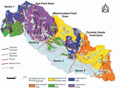
5.1. Sector 1
Consists of three superimposed tectonic units represented respectively, from the top to the bottom by the AP, L2 and L1 units bounded to the SE by the Agri Fault Zone (). It consists of a high angle, NNE-SSW oriented fault dipping toward WNW. The fault zone follows approximately the higher Agri River course and shows the Monte Facito Formation at the hangingwall and the Galestri 1 Formation at the footwall. Slip indicators collected along the Marsico Nuovo Hill suggested a probably right-lateral strike slip kinematics.
In Sector 1, the thrust which superimposes the AP carbonates onto the L2 deposits (Monti della Maddalena Thrust; CitationBucci et al., 2014) can regularly be followed between Castel di Lepre and Santino and in the Torrente Melaggio tectonic window (a), where the L2 Unit is affected by a NW-trending fold (b). The thrust plane consists of a SW gently – dipping surface with a dip angle ranging from 5° to 30° and top-to-the-NE sense of transport (c). Variable orientations and higher dip angles are generally related to tilting connected to later faulting. A 1–10 m thick shear zone, showing different types of deformation based on the lithologies involved, is developed mainly at the footwall of the main thrust surface. Fault breccia and slickensided surfaces, generally characterize brittle lithologies whereas plastic deformation such as S–C tectonites and folding typically involve thin – bedded, clayey and shaly successions (d,e). The younger unit involved at the thrust footwall is represented by the FYR, whereas the FMS represents the younger units recognized at the hangingwall. This provides a time constrain for the thrust activity. As concerning this latter formation, the apparent unconformity contacts with the older units, widely observable in the Pergola area, is considered the result of post-emplacement gravitational collapse, linked to later fault-related block tilting. In the Sector 1 minor thrust surfaces, affecting the Lagonegro 2 Unit and cutting at the base the GAL2 and the SCS2 formations, have also been recognized.
Figure 5. Tectonic structures exposed in the Sector 1. (A) Detail of the Torrente Melaggio tectonic window (refer to the Main Map for the legend); (B) Lower hemisphere equal area stereographic projections of poles to bedding planes at Torrente Melaggio. The third eigenvalue shows the orientation of the fold axis; (C) Outcrop photograph of the Monti della Maddalena thrust surface; (D) Detail and (E) Interpretation of the thrust shear zone showing S-C tectonites which provide a top-toward-NE sense of shear. (F) Detailed sketch map of the Cognone area (refer to the Main Map for the legend); (G) Lower hemisphere equal area stereographic projections of poles to bedding planes at Cognone Anticline. The third eigenvalue shows the orientation of the fold axis.
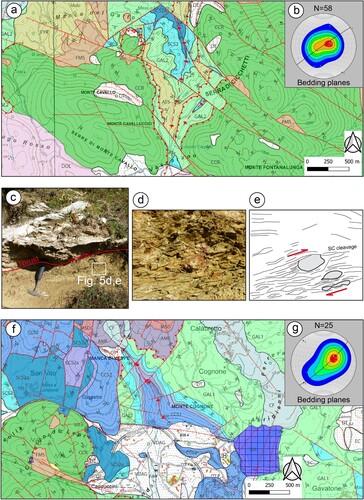
The thrust superimposing the L2 Unit on the L1 Unit (Marsico Nuovo Thrust; CitationBucci et al., 2014) is largely exposed between Pietra Maura and Piana del Lago (Main Map). It generally involves the Monte Facito Formation at the hangingwall and the GAL1 at the footwall. The portion of the Monte Facito Formation serving as decollement surface is generally represented by AMF, although MSD is locally involved. In the Piana del Lago area, the Marsico Nuovo Thrust displays the Piana del Lago Marls (UMI) at the footwall. This allows us to infer that the emplacement of the L2 Unit onto the L1 Unit is younger than the Lower Miocene.
The structural analysis performed in this sector shows that the orientation of the contractional structures is consistent with an overall SW-NE oriented shortening direction. The best evidence is represented by the Cognone Anticline (f), an asymmetrical anticlinal fold of about 1 km in wavelength, exposed at the footwall of the Marsico Nuovo Thrust, involving the L1 Unit, which shows an axis oriented N325°/7° (g).
5.2. Sector 2
This sector is included between the Agri and Marsicovetere fault zones (). This latter consists of two main segments, oriented NE-SW and N-S, respectively. The NE-trending segment mostly dips towards the SE, separating the L2 and L1 units at the footwall from the LI, SI and AP units at the hangingwall. The N-trending segment is nearly vertical, displaying pure dextral strike-slip kinematics. Tectonic slices made up of carbonates and sandstones, of the AP and the SY respectively, have been recognized along the N-trending segment, immediately SE of Monte Torrette (Main Map).
In Sector 2 the L1 Unit is widely exposed, with limited outcrops of L2 and AP units. The most striking characteristic of this area is represented by the occurrence of km-scale, symmetrical and asymmetrical folds affecting the L1 deposits (). Magnificent exposures are represented by the Monte Lama, Serra di Calvello, Monte San Nicola and the Monte Volturino folds (a,b).
Figure 6. Tectonic structures exposed in the Sector 2. Portions of the geological map (refer to the Main Map for the legend) illustrating (A) the Monte Lama – Calvelluzzo – Monte San Nicola (numbered rectangles are referred to stereoplots in E) and (B) the Volturino structures (numbered rectangles are referred to stereoplots in G); (C) Panorama view of the Monte Lama Anticline from the SW and (D) relative interpretation; (E) Lower hemisphere equal area stereographic projections of poles to bedding planes showing the progressive rotation of the fold axes trends along the Monte Lama – Calvelluzzo – Monte San Nicola structure. The third eigenvalues show the orientation of the fold axes; (F) Panorama view of the Volturino anticline-syncline structure from the SW; (G) Lower hemisphere equal area stereographic projections of poles to bedding planes at Monte Volturino. The third eigenvalues show the orientation of the fold axes.
According to CitationMazzoli et al. (2001) folding is accomplished by buckling mechanisms which is favoured by the thin-bedded, multi-layered nature of the involved successions which show strong competence differences. These folds show a predominant box geometry (c,d), with double anticlinal hinge zones (b) and locally overturned or faulted limbs. Along the Monte Lama-Serra di Calvello-Monte San Nicola Structure (a) the fold axes orientation significantly changes from NW-SE to N-S and NNE-SSW (e), from the northern to the southern portions of the area, according to an arcuate shape. Accordingly, N-S to NNE-SSW axial trends have been obtained at Monte Volturino (f,g).
In the remaining part of the area, although poorly exposed, the tectonic contact between the L2 and L1 units occurs immediately SW of Marsico Nuovo, at the Sant’Elia locality (Main Map) and along the valley separating Monte Calvelluzzo from Monte Volturino (Romanelli area; Main Map). In this latter locality, a klippen formed by the MSD and the overlying CCS2 overthrust onto the GAL1. The AP carbonates occur in a series of klippen, which overthrust the L2 Unit along the eastern and southern sides of Monte Volturino at Scarrone di Mezzo and Serritello (Main Map).
5.3. Sector 3
This sector is bounded by the Marsicovetere Fault to the NW and the Torrente Casale Fault to the SE (). This latter consists of a roughly NE-trending and SE-dipping normal fault, bounding the eastern side of the Monte Caldarosa-Monte S. Enoc structure and extending to the eastern slope of the Viggiano town hill. The fault shows the L2 Unit deposits at the footwall and the LI Unit with the overlying SY deposits, at the hangingwall.
Sector 3 differs from the previous sectors for the absence of the L1 Unit and the occurrence of the LI and SI terrains, resting tectonically above the L2 Unit. The main structural feature is represented by the tectonic superposition of the LI thrust sheet onto the SI, AP and L2 units. In particular, the contact with the SI Unit consists of a very poorly exposed thrust surface indicated in the map as an undefined tectonic contact. More obvious is the superposition of the LI onto the L2 deposits which can be traced S of Monte Pilato and W of the Monte Caldarosa area (Main Map) (a). The occurrence of ATS at the footwall of the thrust allows to provide an age not older than the Upper Oligocene for the thrusting phase. The tectonic superposition of the LI and SI onto the AP carbonates is not exposed in the study area. However, thrusting of the LI and SI onto the AP is consistent with data about the tectonic load obtained from marly intervals in the AP carbonates exposed at the Monte di Viggiano (Main Map), which indicate that carbonates have been subjected to 4–5 km of tectonic burial (CitationManniello et al., 2022).
Figure 7. Tectonic structures exposed in Sector 3. (A) Portion of the geological map illustrating the Monte Caldarosa – Monte S. Enoc – Torrente Alli anticlines (numbered rectangles are referred to stereoplots in D) (refer to the Main Map for the legend); (B) Panorama view of the Monte Caldarosa Anticline from the S; (C) Interpretation. (D) Lower hemisphere equal area stereographic projections of poles to bedding planes in Sector 3; the third eigenvalues show the orientation of the fold axes; (E) Portion of the geological map illustrating the Rupe Rossa Thrust area (refer to the Main Map for the legend). (F) Panorama view of the Rupe Rossa Thrust from the SW; (G) Outcrop interpretation; (H) Close up view of the Rupe Rossa Thrust showing slickensides and folds at the hangingwall and footwall respectively.
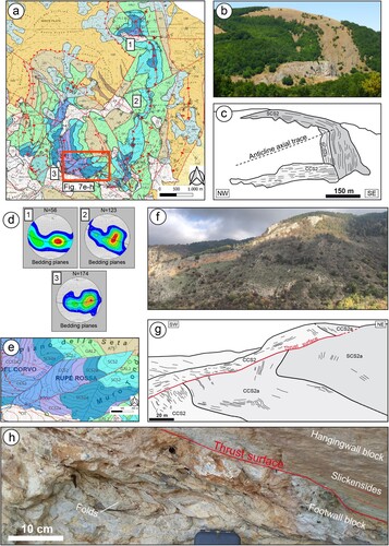
At Viggiano, and in the proximity of the Monte di Viggiano area, the L2 Unit deposits are also overlain by the AP carbonates along the Monti della Maddalena thrust (Section B-B’ in the Main Map). This tectonic contact is never clearly exposed in the study area. However, at La Raia, SE of the Monte di Viggiano (Main Map), it is possible to observe at least three m-scale tectonic slices of the GAL2 that are included within a duplex formed by the platform carbonates. The L2 Unit is also affected by complex contractional deformation as showed by the Monte S. Enoc-Monte Caldarosa fold (a–c). It consists of a km-scale, asymmetric anticline showing a moderate arcuate shape in map view, with fold axis trends varying from NW-SE to N-S and NNE-SSW (d). The axial plane shows an average dip direction toward WNW. The structure, showing a NW gently dipping limb and a steeply-dipping or locally overturned southeastern limb, is associated to a series of deep-seated thrusts represented in the Section A-A’ (Main Map) and can be interpreted as a fault propagation fold.
Other contractional structures are represented by a km-scale N-trending anticline affecting the L2 Unit at the Torrente Alli, N of Viggiano (a, d) and the Rupe Rossa Thrust (e–g). This NW-dipping thrust crosscuts the Eastern limb of the anticline, involving both the CCS2 and the CCS2a members. Intense and disharmonic folds develop at the footwall of the thrust within CCS2a, while the thrust surface consists of a sharp and slickensided surface, with scarce fault gouge (h).
5.4. Sector 4
This sector includes the portion on the map located to the SE of the Torrente Casale Fault Zone (). In this area, the FAB and FGO formations are mainly exposed. However, some outcrops, pertaining to the L2 Unit, also occur at Serra Carlea (Main Map), at the footwall of a NW-trending normal fault. Km-scale folds in the FAB and FGO formations have been recently described in CitationProsser et al. (2021). The contact between the SY and the underlying units is represented by a regional unconformity.
5.5. Other structures
5.5.1. Low angle normal faults (LANFs)
These structures, formed during the Pliocene to Lower Pleistocene, are associated to the early extensional deformation affecting the Southern Apennine allochtonous sheets (CitationBucci et al., 2014; CitationFerranti et al., 1996; CitationMazzoli et al., 2008). They commonly reactivate pre-existing tectonic or stratigraphic discontinuities and are particularly well-preserved in the carbonate deposits pertaining to the AP and the Lagonegro Basin units (CitationBucci et al., 2012; CitationNovellino et al., 2015). LANFs strike N-S or NW-SE, display a listric geometry, with dip angles ranging from 3° to 30°.
5.5.2. High angle faults
These tectonic structures were active between the Lower Pleistocene to the Quaternary, thereby decisively contributing to the opening of the Agri Valley. They consist of normal and strike-slip faults with dip angles ranging from 40° to 90° (CitationCatalano et al., 1993; CitationHippolyte et al., 1994; CitationMonaco et al., 1998).
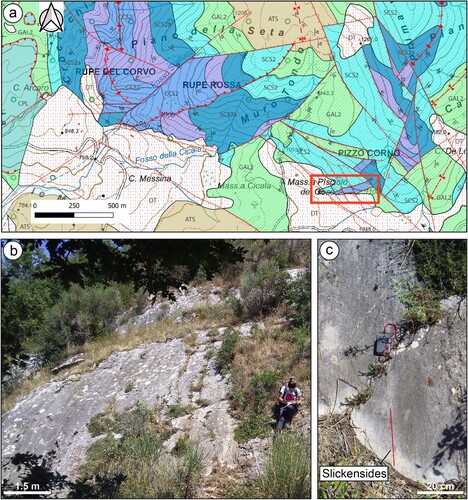
N110°–120° and N140°–160° oriented normal and strike-slip (both transpressional and transtensional) faults which mainly shaped the high Agri Valley. Kinematic indicators, mainly represented by slickensides and calcite steps, usually show a sequence of events with strike slip faults reactivated as normal faults. Strike slip faults are attributable to the East Agri Fault System (EAFS; CitationCello et al., 2000; CitationMaschio et al., 2005), which is best exposed along the southwestern slope of the Monte di Viggiano ridge. The involvement of the Brecce di Galaino and the occurrence of growth structures allows to constrain the faults activity to the Lower-Middle Pleistocene (CitationGiano et al., 2000). Nearly E-W striking normal faults, compartimentalized by N140° trending faults, have also locally been recognized. Clear examples are exposed at Pizzo Corno (Main Map) (a–c).
Figure 8. E-W oriented normal fault exposed at Pizzo Corno. (A) Portion of the geological map illustrating the Pizzo Corno area (refer to the Main Map for the legend). The considered faults are included in the red rectangle; (B) Fault plane view from the S; (C) Detail of the fault plane showing dip-slip oriented slickensides.
N-S to N40° striking faults form a set of fist-order structures responsible for the dissection of most of folds and thrusts, allowing for the exposure of different structural levels of the thrust and fold belt in the four homogeneous sectors recognized in the study area. They generally consist of normal faults; however, a subsequent dextral strike slip activity has been documented in the Cognone area (CitationMazzoli et al., 2004). N30° normal faults delimiting the SE-side of the Monte S. Enoc – Caldarosa ridge form a series of splays with the Lagonegro units at the footwall and the FAB and FGO formations at the hangingwall. In the Montemurro area, deep-rooted normal faults, related to this set, affect the FAB (CitationProsser et al., 2021).
6. Discussion and conclusions
In this paper, we present the geological map of the north-eastern flank of the Agri Valley which encompasses an area of about 350 Km2. The map is based on detailed stratigraphic subdivisions which took into consideration not only the single formations but also, when possible, lower rank units such as members or beds. This has allowed us to successfully define the tectonic structures with a greater amount of detail, that would otherwise not possible using a simple formational subdivision approach. It also allowed to newly recognize and map for the first time previously overlooked stratigraphic units. Based on the new data we divided the whole area into four sectors, bounded by first-order NE-trending faults (). The main criteria considered for defining the four sectors are the exposure of specific tectonic units and the homogeneous orientation and geometry of the tectonic structures. Using this approach some general considerations are possible:
Moving from NW to SE, the different sectors show the involvement of tectonically higher units. This means that the NE-trending faults, although characterized by complex and possibly polyphase kinematics, produce a general uplift of the north-western sectors with respect to the south-eastern portions of the area.
Passing from Sector 1 to Sector 4, orientations of fold axial traces and thrusts vary from NW-SE, the typical Apennine trend, to N-S and NE-SW. In some cases, trend variations can be observed in map view along a single structure providing an arc-shaped geometry (see the Monte S. Enoc-Monte-Caldarosa anticline or the Serra di Calvello and Monte San Nicola anticline system on the Main Map). This indicates non-cylindrical development of folds in different sectors of the study area.
The different tectonic units show different structural styles. In particular, the deepest unit, represented by the L1 Unit, are characterized by folds showing a box geometry. Conversely, the L2 Unit show folds characterized by an asymmetric geometry, consistent with their interpretation as fault-propagation folds. The Apennine Platform is affected only by gentle folds showing local amplification in the frontal ramp area (at the Monte di Viggiano see the Main Map). The uppermost Liguride and Sicilide units, show strong internal structural complexities with tight or overturned folds, inherited by older tectonic phases.
Combining the new stratigraphic and structural data a more detailed reconstruction of the tectonic evolution of the study area is possible. According to the previous models (CitationPatacca & Scandone, 2007 and references therein), emplacement of most of the Southern Apennine nappes in the Agri Valley occurred during the Lower-Middle Miocene time. The time constrain for the contractional tectonics is consistent with the involvement, at the base of the main thrusts, of the Lower Miocene ATS and UMI formations. The contractional phases were followed by different faulting events showing clear cross-cutting relationships. N-S or NW-SE trending LANFs represent an older tectonic event, followed by NE-SW oriented normal/strike-slip faults. These latter faults are responsible for the segmentation of the study area in the four sectors previously described. Younger E-W and NW-SE oriented normal and strike-slip (transtensional) faults mostly controlled the opening of the Agri Valley tectonic depression, cutting the older structures as evident for the Torrente Casale Fault Zone. Anomalous fault cross-cutting relationships, differing from the previously proposed tectonic scheme, are attributed to the reactivation of the NE-SW trending faults as transfer faults, connected the activity of the NW-SE trending normal faults.
Software
Outcrops have been georeferenced in the field by means of an open-source mobile phone app (Geopaparazzi by Hydrologis; www.geopaparazzi.org). Lithological data, bedding attitude and structural measurements have been obtained in each outcrop. This information has been imported in the QGIS 3.22 LTR open-source software (www.qgis.org), that has been used to construct the geological map, to manage attitude and structural data and to produce the initial layout at 1:30.000 scale. The final layout of the geological map, including the legend, the geological cross-sections and the index map, has been obtained with Adobe Illustrator.
Map.pdf
Download PDF (114.9 MB)Acknowledgements
The authors gratefully acknowledge the reviewers Dr. Simone Fabbi (Sapienza University), Dr. Edoardo Barbero, (Ferrara University) and Dr. Mike Shand (University of Glasgow) for the very constructive comments and suggestions. We wish to thank colleagues and students that greatly supported us during the field survey. These people are listed as follows: Mariassunta Musto, Michele Tricarico, Antonella Caputi, Rocco Alessio Iritano, Tonia Loisi and Annarita Colucci. We are also grateful to Daniele Catellani (ENI), Marcello Riva (ENI) and Martina Balestra (ENI) that supported us in understanding the subsurface geology of the Agri Valley and provided biostratigraphic support.
Data availability statement
The data that support the findings of this study are openly available in ‘Figshare’ at https://doi.org/10.6084/m9.figshare.20010170.
Disclosure statement
No potential conflict of interest was reported by the author(s).
Additional information
Funding
References
- Amodeo, F. (1999). Il Triassico terminale – Giurassico del Bacino Lagonegrese. Studi stratigrafici sugli Scisti Silicei della Basilicata (Italia meridionale). Mèm. Gèol. (Lausanne), 33, 121pp.
- Baldacci, L., & Sabatini, V. (1908). Foglio 199 “Potenza”. Servizio geologico d’Italia.
- Baldacci, L., Sabatini, V., & Viola, C. (1908). Foglio 210 “Lauria”. Servizio geologico d’Italia.
- Baruffini, L., Lottaroli, F., Torricelli, S., & Lazzari, D. (2000). Stratigraphic revision of the Eocene Albidona formation in the type locality (Calabria, southern Italy). Rivista, Italiana di Paleontologia e Stratigrafia, 106 (1), 73–98.
- Bentivenga, M., Gizzi, F. T., Palladino, G., Piccarreta, M., Potenza, M. R., Perrone, A., Bellanova, J., Calamita, G., & Piscitelli, S. (2022). Multisource and multilevel investigations on a historical landslide: The 1907 Servigliano earth flow in Montemurro (Basilicata, Southern Italy). Land, 11(3), 408. https://doi.org/10.3390/land11030408
- Bentivenga, M., Palladino, G., & Caputi, A. (2012). Development of the Pietra Maura landslide and interactions with the Marsico Nuovo dam (Basilicata - Italy). Geografia Fisica e Dinamica del Quaternario, 35, 13–22. https://doi.org/10.4461/GFDQ.2012.35.2
- Bertinelli, A., Ciarapica, G., De Zanche, V., Marcucci, M., Mietto, P., Passeri, L., Rigo, M., & Roghi, G. (2005). Stratigraphic evolution of the Triassic – Jurassic Sasso di Castalda succession (Lagonegro basin, southern Apennines, Italy). Bollettino della Società Geologica Italiana, 124, 161–175.
- Boiano, U. (1997). Anatomy of a siliciclastic turbidite basin: The Gorgoglione Flysch, Upper Miocene, southern Italy: Physical stratigraphy, sedimentology and sequence-stratigraphic framework. Sedimentary Geology, 107(3-4), 231–262. https://doi.org/10.1016/S0037-0738(96)00023-1
- Bonardi, G., Amore, F. O., Ciampo, G., De Capoa, P., Miconnet, P., & Perrone, V. (1988). Il complesso liguride auct.: stato delle conoscenze e problemi aperti sulla sua evoluzione pre-appenninica ed i suoi rapporti con l’Arco Calabro. Memorie della Società Geologica Italiana, 41, 17–35.
- Bonardi, G., Ciampo, G., & Perrone, V. (1985). La Formazione di Albidona nell’Appennino calabro-lucano: Ulteriori dati stratigrafici e relazioni con le unità esterne appenniniche. Bollettino della Società Geologica Italiana, 104, 539–549.
- Bucci, F., Novellino, R., Guglielmi, P., Prosser, G., & Tavarnelli, E. (2012). Geological map of the northeastern sector of the high Agri Valley, Southern Apennines (Basilicata, Italy). Journal of Maps, 8(3), 282–292. https://doi.org/10.1080/17445647.2012.722403
- Bucci, F., Novellino, R., Guglielmi, P., & Tavarnelli, E. (2020). Growth and dissection of a fold and thrust belt: The geological record of the high Agri Valley, Italy. Journal of Maps, 16(2), 245–256. https://doi.org/10.1080/17445647.2020.1737254
- Bucci, F., Novellino, R., Tavarnelli, E., Prosser, G., Guzzetti, G., Cardinali, M., Gueguen, E., Guglielmi, P., & Adurno, I. (2014). Frontal collapse during thrust propagation in mountain belts: A case study in the Lucanian Apennines, Southern Italy. Journal of the Geological Society, 171(4), 571–581. https://doi.org/10.1144/jgs2013-103
- Carbone, S., Catalano, S., Lazzari, S., Lentini, F., & Monaco, C. (1991). Presentazione della carta geologica del bacino del Fiume Agri. Memorie della Società Geologica Italiana, 47, 129–143.
- Castellano, M. C., & Sgrosso, I. (1996). Età e significato dei depositi miocenici della Formazione di Monte Sierio e possibile evoluzione cinematica dell’Unità Monti della Maddalena nell’Appennino campano-lucano. Memorie della Società Geologica Italiana, 51, 239–249.
- Catalano, S., Monaco, C., Tortorici, L., & Tansi, C. (1993). Pleistocene strike-slip tectonics in the Lucanian Apennine (southern Italy). Tectonics, 12(3), 656–665. https://doi.org/10.1029/92TC02251
- Cavalcante, F., Belviso, C., Laurita, S., & Prosser, G. (2012). P-T constraints from phyllosilicates of the liguride complex of the pollino area (southern Apennines, Italy): Geological inferences. Ofioliti, 37, 65–75. https://doi.org/10.4454/ofioliti.v37i2.406
- Cello, G., Gambini, R., Mazzoli, S., Read, A., Tondi, E., & Zucconi, V. (2000). Fault zone characteristics and scaling properties of the Val d’Agri fault system (southern Apennines, Italy). Journal of Geodynamics, 29(3-5), 293–307. https://doi.org/10.1016/S0264-3707(99)00043-5
- Cestari, R., & Laviano, A. (2012). Rudist facies distribution in the late Cretaceous of Cilento and western Basilicata. Rivista Italiana di Paleontologia e Stratigrafia, 118, 277–294.
- Ciarapica, G., & Passeri, L. (2000). Le facies del Triassico inferiore e medio (fm. di Monte Facito Auctt.) nelle aree di Sasso di Castalda e di Moliterno (Basilicata). Bollettino della Società Geologica Italiana, 119, 339–378.
- Colella, A. (2003). Le risorse idriche sotterranee dell’Alta Val d’Agri. Autorità Interregionale di Bacino della Basilicata, Collana Editoriale di Studi e ricerche, n. 3, pp. 399, Potenza.
- D’Argenio, B., Pescatore, T., & Scandone, P. (1973). Schema geologico dell’Appennino Meridionale. Atti del convegno «Moderne vedute sulla geologia dell’Appennino». Acc. Naz. Lincei, Quaderno, 183, 49–72.
- Ferranti, L., Oldow, J. S., & Sacchi, M. (1996). Pre-Quaternary orogen-parallel extension in the Southern Apennine belt, Italy. Tectonophysics, 260(4), 325–347. https://doi.org/10.1016/0040-1951(95)00209-X
- Festa, A., Barbero, E., Remitti, F., Ogata, K., & Pini, G. A. (2022). Mélanges and chaotic units: Implication for exumed subduction complexes and orogenic belts. Geosystems and Geoenvironments, 1(2), 100030. https://doi.org/10.1016/j.geogeo.2022.100030
- Giannandrea, P., Loiacono, F., Maiorano, P., Lirer, F., & Puglisi, D. (2016). Geological map of the eastern sector of the Gorgoglione Basin (southern Italy). Italian Journal of Geosciences, 135(1), 120–141. https://doi.org/10.3301/IJG.2015.05
- Giano, S. I. (2011). Quaternary alluvial fan systems of the agri intermontane basin (southern Italy): Tectonic and climatic controls. Geologica Carpathica, 62(1), 65–76. https://doi.org/10.2478/v10096-011-0006-y
- Giano, S. I. (2016). Geomorphology of the agri intermontane basin (val d'Agri-Lagonegrese National Park, Southern Italy). Journal of Maps, 12(4), 639–648. https://doi.org/10.1080/17445647.2015.1068715
- Giano, S. I., Maschio, L., Alessio, M., Ferranti, L., Improta, S., & Schiattarella, M. (2000). Radiocarbon dating of active faulting in the agri high valley, southern Italy. Journal of Geodynamics, 29(3-5), 371–386. https://doi.org/10.1016/S0264-3707(99)00058-7
- Giordano, N., Ciarapica, G., Bertinelli, A., & Rigo, M. (2011). The Norian - Rethian interval in two sections of the lagonegro area: The transition from carbonate to siliceous deposition. Italian Journal of Geosciences, 130, 380–393.
- Gueguen, E., Bentivenga, M., Colaiacovo, R., Margiotta, S., Summa, V., & Adurno, I. (2015). The Verdesca landslide in the Agri Valley (Basilicata, Southern Italy): A new geological and geomorphological framework. Natural Hazards and Earth System Sciences, 15(11), 2585–2595. https://doi.org/10.5194/nhess-15-2585-2015
- Guido, A., Palladino, G., Sposato, M., Russo, F., Prosser, G., Bentivenga, M., & Mastandrea, A. (2021). Reconstruction of tectonically disrupted carbonates through quantitative microfacies analyses: An example from the middle triassic of southern Italy. Facies, 67(3), 22. https://doi.org/10.1007/s10347-021-00631-2
- Hippolyte, J. C., Angelier, J., & Roure, F. (1994). A major geodynamic change revealed by quaternary stress patterns in the southern Apennines (Italy). Tectonophysics, 230(3-4), 199–210. https://doi.org/10.1016/0040-1951(94)90135-X
- ISPRA. (2005). Carta Geologica d’Italia alla Scala 1:50,000, Foglio 506 “Sant’Arcangelo”.
- ISPRA. (2012). Carta Geologica d’Italia alla Scala 1:50,000, Foglio 489 “Marsico Nuovo”.
- ISPRA. (2014a). Carta Geologica d’Italia alla Scala 1:50,000, Foglio 505 “Moliterno”.
- ISPRA. (2014b). Carta Geologica d’Italia Alla Scala 1:50,000, Foglio 521 “Lauria”.
- Lentini, F. (1979). Le unità Sicilidi della Val d’Agri. Geologica Romana, 18, 215–224.
- Manniello, C., Todaro, S., Cavalcante, F., & Prosser, G. (2022). Fracture stratigraphy of Mesozoic platform carbonates, Agri Valley, southern Italy. Geological Magazine, 159(11-12), 1874–1896. https://doi.org/10.1017/S0016756822000322
- Marsella, E., Kozur, H., & D’Argenio, B. (1993). Monte Facito Formation (Schitian–middle Carnian). A deposit of the ancestral Lagonegro Basin in the Southern Apennines. Bollettino del Servizio Geologico d’Italia, 110, 225–248.
- Marsella, E., & Pappone, G. (1987). Sediment gravity flows on a Mesozoic carbonate slope Monti della Maddalena (Southern Apennines). Rendiconti Online Società Geologica Italiana, 9, 219–224.
- Maschio, L., Ferranti, L., & Burrato, P. (2005). Active extension in Val d’Agri area, southern Apennines, Italy: Implications for the geometry of the seismogenic belt. Geophysical Journal International, 162(2), 591–609. https://doi.org/10.1111/j.1365-246X.2005.02597.x
- Mazzoli, S., Barkham, S., Cello, G., Gambini, R., Mattioni, L., Shiner, P., & Tondi, E. (2001). Reconstruction of continental margin architecture deformed by the contraction of the Lagonegro Basin, southern Apennines, Italy. Journal of the Geological Society, 158(2), 309–319. https://doi.org/10.1144/jgs.158.2.309
- Mazzoli, S., D’Errico, M. Aldega, L., Corrado, S., Invernizzi, C., Shiner, P., & Zattin, M. (2008). Tectonic burial and “young” (<10 Ma) exhumation in the southern Apennines fold-and-thrust belt (Italy). Geology, 36(3), 243–246. https://doi.org/10.1130/G24344A.1
- Mazzoli, S., Invernizzi, C., Marchegiani, L., Mattioni, L., & Cello, G. (2004). Brittle-ductile shear zone evolution and fault initiation in limestones, Monte Cugnone (Lucania), southern Apennines, Italy. Geological Society, London, Special Publications, 224(1), 353–373. https://doi.org/10.1144/GSL.SP.2004.224.01.22
- Menardi-Noguera, A., & Rea, G. (2000). Deep structure of the Campanian–Lucanian Arc (Southern Apennine, Italy). Tectonophysics, 324(4), 239–265. https://doi.org/10.1016/S0040-1951(00)00137-2
- Miconnet, P. (1988). Evolution mésozoique du secteur de Lagonegro. Memorie della Società Geologica Italiana, 41, 321–330.
- Monaco, C., Tortorici, L., & Paltrinieri, W. (1998). Structural evolution of the Lucanian Apennines. Journal of Structural Geology, 20(5), 617–638. https://doi.org/10.1016/S0191-8141(97)00105-3
- Novellino, R., Prosser, G., Spiess, R., Viti, C., Agosta, F., Tavarnelli, E., & Bucci, F. (2015). Dynamic weakening along incipient low-angle normal faults in pelagic limestones (Southern Apennines, Italy). Journal of the Geological Society, 172(3), 283–286. https://doi.org/10.1144/jgs2014-091
- Ogniben, L. (1969a). Note illustrative della Carta Geologica d’Italia 1 100000 Foglio 211 Sant’Arcangelo. Servizio geologico d’Italia.
- Ogniben, L. (1969b). Schema introduttivo alla geologia del confine calabro-lucano. Memorie della Societa Geologica Italiana, 8, 453–763.
- Olita, F., Giampaolo, V., Rizzo, E., Palladino, G., Capozzoli, L., De Martino, G., & Prosser, G. (2023). Investigation of the geological structure of the Tramutola area (Agri Valley): Inferences for the presence of geofluids at shallow crustal levels. Geosciences, 13(3), 83. https://doi.org/10.3390/geosciences13030083
- Palladino, G. (2015). Determining the way-up of the Monte Facito formation using new sedimentological data from the ‘La Cerchiara’ succession, Southern Apennines. Italian Journal of Geosciences, 134(1), 120–133. https://doi.org/10.3301/IJG.2014.59
- Palladino, G., Parente, M., Prosser, G., & Di Staso, A. (2008). Tectonic control on the deposition of the lower Miocene sediments of the Monti della Maddalena ridge (Southern Apennines): Synsedimentary extensional deformation in a foreland setting. Bollettino della Società Geologica Italiana, 127(2), 317–335.
- Palladino, G., Prosser, G., Bentivenga, M., & Alsop, G. I. (2019). Mass transport deposits overprinted by contractional tectonics: A case study from the southern Apennines of Italy. Geological Magazine, 156(5), 849–873. https://doi.org/10.1017/S0016756818000213
- Panzanelli Fratoni, R. (1991). Analisi stratigrafica della «Formazione del M. Facito» Auctt. (serie di Lagonegro-Appennino Meridionale). Proposta di istituzione del Gruppo di Monte Facito. Unpublished thesis, Università degli Studi di Perugia, Perugia, Italy.
- Patacca, E., & Scandone, P. (2007). Geology of the southern Apennines. Bollettino della Società Geologica Italiana, 7, 75–119.
- Pescatore, T., Renda, P., Schiattarella, M., & Tramutoli, M. (1999). Stratigraphic and structural relationships between Meso-Cenozoic Lagonegro basin and coeval carbonate platforms in southern Apennines, Italy. Tectonophysics, 315(1-4), 269–286. https://doi.org/10.1016/S0040-1951(99)00278-4
- Prosser, G., Palladino, G., Avagliano, D., Coraggio, F., Bolla, E. M., Riva, M., & Catellani, D. E. (2021). Stratigraphic and tectonic setting of the Liguride units cropping out along the southeastern side of the Agri Valley (southern Apennines, Italy). Geosciences, 11(3), 125. https://doi.org/10.3390/geosciences11030125
- Rigo, M., Preto, N., Franceschi, M., & Guaiumi, C. (2012). Stratigraphy of the Carnian – Norian Calcari con Selce formation in the Lagonegro Basin, southern Apennines. Rivista Italiana di Paleontologia e Stratigrafia, 118, 143–154.
- Rigo, M., Preto, N., Roghi, G., Tateo, F., & Mietto, P. (2007). A rise in the carbonate compensation depth of western Tethys in the Carnian (Late Triassic): Deepwater evidence for the Carnian pluvial event. Palaeogeography, Palaeoclimatology, Palaeoecology, 246(2-4), 188–205. https://doi.org/10.1016/j.palaeo.2006.09.013.
- Scandone, P. (1967). Studi di geologia lucana: la serie calcareo-silico-marnosa e i sui rapporti con l’Appennino calcareo. Boll. Soc. Nat. in Napoli, 76, 1–175.
- Scandone, P. (1971). Note illustrative della Carta Geologica d’Italia 1:100000 Fogli 199 - 210 Potenza e Lauria.
- Scandone, P. (1972). Studi di geologia lucana: Carta dei terreni della serie calcareo-silico-marnosa e note illustrative. Boll. Soc. Nat. in Napoli, 81, 225–300.
- Scandone, P., & Bonardi, G. (1968). Synsedimentary tectonics controlling deposition of mesozoic and tertiary carbonatic sequences of areas surrounding Vallo di Diano (Southern Apennines). Memorie della Società Geologica Italiana, 7, 1–10.
- Selli, R. (1962). Il paleogene nel quadro della geologia dell’Italia meridionale. Memorie della Società Geologica Italiana, 3, 737–789.
- Shiner, P., Beccacini, A., & Mazzoli, S. (2004). - Thin-skinned versus thick-skinned structural models for apulian carbonate reservoirs: Constraints from the Val d’Agri fields, S Apennines, Italy. Marine and Petroleum Geology, 21(7), 805–827. https://doi.org/10.1016/j.marpetgeo.2003.11.020
- Torricelli, S., & Amore, M. R. (2003). Dinoflagellate cysts and calcareous nannofossils from the upper cretaceous saraceno formation (calabria, Italy): implications about the history of the liguride complex. Rivista Italiana di Paleontologia e Stratigrafia, 109(3), 499–516.
- Wood, A. W. (1981). Extensional tectonics and the birth of the Lagonegro Basin (Southern Italian Apennines). Neues Jahrbuch für Geologie und Palaeontologie Abhandlungen, 161, 93–131.
- Zembo, I. (2010). Stratigraphic architecture and quaternary evolution of the Val d’Agri intermontane basin (southern Apennines, Italy). Sedimentary Geology, 223(3-4), 206–234. https://doi.org/10.1016/j.sedgeo.2009.11.011
- Zuccari, C., Vignaroli, G., & Viola, G. (2021). Geological map of the San Donato – Costa thrust zone, Belluno thrust system, eastern Southern Alps (northern Italy). Journal of Maps, 17(2), 337–347. https://doi.org/10.1080/17445647.2021.1946444