
ABSTRACT
Landslide inventory maps are the first and main information level in studies of reactivation of previous landslides and susceptibility, hazard and risk maps of future landslides. Due to its geographical location and tectonic setting, the Dominican Republic is exposed to several geological risks, among which landslides stand out. In this study, we present a landslide inventory elaborated in three selected zones with particular geographical, lithological, tectonic and climatic characteristics: Puerto Plata, Santiago de los Caballeros and Jarabacoa. A total of 6085 landslides have been recorded (56% in S, 29% in P and 15% in J), which have been classified according to their geometry, propagation mechanism, affected material, thickness and activity. The detected factors that control the distribution and type of gravitational deposits are lithology and geologic structure, as well as rainfall and active faulting along the Camú, Septentrional and Bonao-La Guácara fault zones.
1. Introduction
The Dominican Republic, due to its geographical location and tectonic setting on the northern boundary of the Caribbean Plate, is exposed to several geological risks, among which landslides are very frequent (CitationMuñoz et al., 2009; Citation2017; CitationRoopnarine et al., 2020; CitationUrien, 2011). Landslides are one of the most frequent natural hazards worldwide, causing numerous personal injuries and material damages (CitationHaque et al., 2019).
Landslide inventory maps are fundamental in the management of these gravitational processes (Citationvan Westen et al., 2008). In this study, we present a landslide inventory of three selected zones of the Dominican Republic (Puerto Plata, Santiago de los Caballeros and Jarabacoa), made from previous geological and geomorphological maps (SYSMIN Project), photo-interpretation of satellite images (Google Earth Pro; http://earth.google.com) and fieldwork.
The two main targets of this landslide inventory are: (i) making a map with a GIS-based database, describing their geometry, detection, propagation mechanism, affected material, thickness and activity and (ii) analysing the relationship between landslides and their destabilizing factors as lithology, structure, rainfall or active faulting.
2. Study zones
This study is focused in three zones: Puerto Plata, Santiago de los Caballeros and Jarabacoa. These zones have diverse lithological, tectonic and climatic attributes, combined with a high population density and high economic activity. These characteristics have special significance to compare landslide inventory maps and may be relevant for further analyses of landslide susceptibility.
The Hispaniola Island (second largest island of the Greater Antilles) is located in the northern boundary of the Caribbean Plate, which is moving towards the E and ENE, relative to the North American Plate (see The Geology of Hispaniola in the Main Plate). This displacement, predicted in the plate models, has been confirmed by GPS data (CitationSymithe et al., 2015). The convergence between both plates produced an oblique collision between the Caribbean island-arc and the southern continental margin of North America in the Eocene (CitationMann et al., 1991; CitationPérez-Estaún et al., 2007), which evolved from the lower Miocene to a regime of transpressive tectonics (CitationDolan et al., 1998; CitationMann et al., 1995). From uppermost Pliocene to present day, these processes induced the uplift of the Cordillera Central, the sinistral transtension of the Cibao basin and the sinistral transpression of the Cordillera Septentrional (CitationEscuder-Viruete & Pérez, 2020).
The study area is located in the northern sector of Hispaniola (Dominican Republic), which morphologically is constituted by two mountain ranges of WNW-ESE to NW-SE trend, separated by a depression. The northern and southern ranges are designated Cordillera Septentrional and Cordillera Central, respectively. Their main elevations are Pico Duarte (3098 m) in Cordillera Central (highest mountain in the Greater Antilles) and Loma Diego de Ocampo (1249 m) in Cordillera Septentrional. The intermediate depression is occupied by the Cibao sedimentary basin.
Due to the present-day transpressive and transtensive tectonic regime, the study area contains several large-scale active fault zones characterized by the frequent occurrence of earthquakes of variable magnitude. The Puerto Plata (P) zone is located on the north coast of the Cordillera Septentrional and is affected by the Camú Fault Zone (CFZ) (Citationde Zoeten & Mann, 1991; CitationPindell & Draper, 1991). The Santiago (S) zone is located on the boundary between the Cordillera Septentrional and the Cibao basin, close to the trace of the Septentrional Fault Zone (SFZ) (CitationMann et al., 1998). The Jarabacoa (J) zone is located on the northern slope of the Cordillera Central, at the contact between the Bonao-La Guácara Fault Zone (BGFZ) and the Jarabacoa basin (CitationEscuder-Viruete, 2011; CitationMann et al., 1991). shows panoramic views of the three zones, the Main Plate includes minor maps of these faults, and the lithological units affected.
The northern sector of Hispaniola, located at 19–20° north latitude, has a subtropical climate, controlled by marine influence, northeast trade winds and the mountain ranges. In this regard, the annual mean temperature and the annual accumulated precipitation are in Puerto Plata, at sea level on the windward side of the Cordillera Septentrional, 25,4° and 842 mm; in Santiago de los Caballeros, at 175 metres above sea level (masl) on the rain shadow of the Cordillera Septentrional, 24.2° and 760 mm; and in Jarabacoa, at 529 masl on the windward side of the Cordillera Central, 20.2° and 1723mm (Data collected between 1991 and 2021 by climate-data.org). These three zones are affected, from August to November, by tropical storms characterised by strong winds with heavy rainfall.
2.1. Puerto Plata zone
The Puerto Plata zone covers an area of 222.9 km2. The main urban areas are San Felipe de Puerto Plata, which is the third most populated city in the Dominican Republic and Imbert (CitationOficina Nacional de Estadística, 2012). Elevations range from 0 m on the shoreline to 766 m on Loma Isabel de Torres. The main fluvial courses are Camú, Bajabonico and Maimón rivers, and, shorter in length, San Marcos and Muñoz rivers.
The geological units of interest in this work are: the sandstones, clays, marls and conglomerates of La Toca Formation (Paleogene–Neogene); the shales and clays with blocks of San Marcos Mélange (Neogene) and the marls, sandy marls, limestones and calcarenites of Villa Trina Formation (Neogene) (CitationHernáiz Huerta, 2010; CitationMonthel, 2010; CitationSuárez-Rodríguez et al., 2017a).
The carbonated Villa Trina Formation occupies the main reliefs of the zone, as Loma Isabel de Torres (766 m) to the E (A) and Loma El Brinco (575 m) to the SW, while the fine-grained siliciclastic units form the smooth reliefs and the valleys.
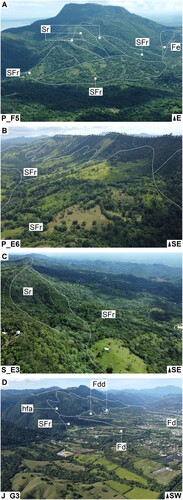
Figure 1. Panoramic views: (A) rock slides, rock slides flows and earth flows at Loma Isabel Torres (766 m), main elevation of P zone; (B) rock slide flows at the CFZ scarp (P zone); (C) rock slide and rock slide flows at the SFZ scarp (S zone); (D) rock slide flows, dry debris flows, dissected debris flows and highly fractured area (hfa) at the BGFZ scarp (J zone). Letters refer to different propagation mechanisms and affected material (see Section 4.3). Dashed and continuous lines delineate, respectively, scarps and boundaries of landslides and continuous line with perpendicular strokes delineates the BGFZ scarp. Lower left key indicates the study zone and panoramic location quadrant (MecMat maps in the Main Plate) and lower right key the panoramic orientation.
The CFZ is a WNW-striking oblique reverse left-lateral fault (B) (CitationEscuder-Viruete et al., 2021; CitationPindell & Draper, 1991). Northwestern of Loma El Brinco (575 m), the fault yuxtaposes the Villa Trina Formation and the San Marcos Mélange.
2.2. Santiago zone
The Santiago zone covers an area of 155.1 km2. This zone is located to the NNE of Santiago de los Caballeros, which is the second most populated city in the Dominican Republic. The main urban area is Tamboril (CitationOficina Nacional de Estadística, 2012). The main fluvial courses are Jacagua, Gurabo, Licey, Canca and Moca rivers. Elevations range from 219 m, just to the ESE of Canca river, to 1063 m, at the Licey river basin head.
The zone includes the following geological units: the sandstones and clays of La Toca Formation (Paleogene); the marls and nodular and calcareous siltites of Altamira Formation (Paleogene); the marls with mudstone and coralline limestone intercalations of Villa Trina Formation (Neogene); and the micritic and reef limestones of Los Haitises Formation (Neogene) (CitationRamírez Merino, 2010; CitationUrien, 2011).
Tectonically, the SFZ is a WNW-striking oblique reverse to strike-slip fault (C). The fault marks an S-facing scarp, which is occupied in its upper part by the carbonated rocks of Los Haitises and Villa Trina Formations and in the lower part by the fine-grained siliciclastic rocks of La Toca and Altamira Formations.
2.3. Jarabacoa zone
The Jarabacoa zone covers an area of 149.4 km2. In the zone, the main urban center is Jarabacoa, which is one of the 40 most populated cities in the Dominican Republic (CitationOficina Nacional de Estadística, 2012). The main fluvial courses are Yaque del Norte (longest river in the Greater Antilles), Baiguate and Jimenoa rivers as well as the Grande, Los Dajaos (I y II) and Cercado streams. Elevations range from 476 m, in the northern part of Jimenoa river, to 1526 m, between Baiguate river and the Cercado stream.
Two main geological units present in the zone are the massive basalts and locally microporphyritic and mafic tuffs of the Pelona-Pico Duarte Formation and the tonalites and leucotonalites of the Río and Junumucu batholits (CitationEscuder-Viruete, 2011; CitationJoubert, 2011). These units outcrop along a steep and fresh-looking scarp conditioned by the BGFZ, which is a W to ENE-striking reverse oblique left-lateral fault (D).
3. Methodology
The landslide inventory maps were developed according to the following stages:
Review of bibliographical documentation that includes: 6 geological maps at scale 1:50,000 in Puerto Plata zone (CitationHernáiz Huerta, 2010; CitationMonthel, 2010), Santiago zone (CitationRamírez Merino, 2010; CitationUrien, 2011) and Jarabacoa zone (CitationEscuder-Viruete, 2011; CitationJoubert, 2011); 1 geological map at scale 1:200,000 in Puerto Plata zone (CitationSuárez-Rodríguez et al., 2017a); and 3 geomorphological maps at scale 1:100.000 in Puerto Plata zone (CitationEscuer Solé, 2010a), Santiago zone (CitationEscuer Solé, 2010b) and Jarabacoa zone (CitationSuárez Rodríguez, 2011).
Review of previous landslide reports (CitationMuñoz et al., 2009; Citation2017) and inventories. In 2013, the SGN initiated a landslide inventory (M. Calzadilla Ribeaux (deceased in 2019), personal communication, Departamento de Geología Ambiental y Aplicada, SGN). To date, the available database includes an inventory of 851 landslides, 7% of which are located in our study zone (Puerto Plata zone).
Photointerpretation of satellite images Google Earth Pro (http://earth.google.com) at scale 1:5000. The comparison of different temporal images, from 2000 to 2021.
Fieldwork at scale 1:25,000 of Puerto Plata, Santiago and Jarabacoa zones (from 30th October to 19th November 2021). A drone DJI Mini 2 was used to obtain a photographic record of the main landslides.
Integration of all the information, delineation of landslides and their storage in a Geographical Information System (ESRI ArcGIS 10.8). For the three zones, the topographic bases were an orthophoto from 2020 at 10 m resolution (https://docs.microsoft.com/en-us/bingmaps) and a Digital Terrain Model at 12 m resolution (LandInfo, Worldwide Mapping Limited Liability Company, Colorado, USA). From these DTMs, a contour model with 10 m of equidistance and a slope model have been derived.
3.1. Landslide detection
Depending on the detection method used, landslides have been differentiated into three types:
Photo-interpreted. Detected landslides using satellite images (Google Earth Pro; http://earth.google.com).
Revised. Detected landslides, from previous landslides reports and inventories and satellite images, and confirmed through fieldwork.
Identified. New landslides detected through fieldwork.
4. Landslide classification
The next sections list and describe the different classifications used for the landslide inventory maps (abbreviations shown in brackets have been used in the database and in the Main Plate). shows some examples of the classified landslides.
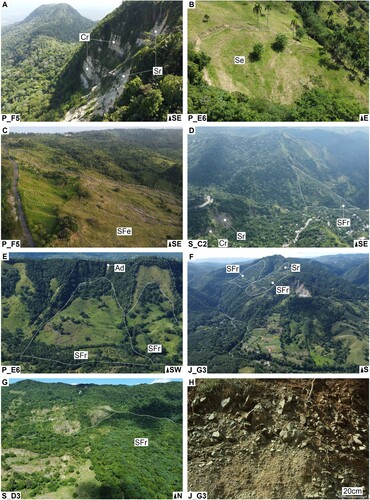
Figure 2. Panoramic views: (A) Rock falls and rock slides (Loma Isabel de Torres, P zone); (B) Earth slide (P zone); (C) Earth slide flow (P zone); (D) Rock fall, rock slide and rock slide flow related to river erosion (S zone); (E) Rock slide flows and debris avalanche in the CFZ scarp (P zone); (F) Rock slide and rock slide flows perched above the river system (J zone); (G) Detail of the head of Carlos Díaz rock slide flow (S zone); (H) Outcrop of a rock slide flow (J zone). Letters refer to different propagation mechanisms and affected material (see Section 4.3). Dashed and continuous lines delineate, respectively, scarps and boundaries of landslides. Lower left key indicates the study zone and panoramic location quadrant (MecMat maps in the Main Plate) and lower right key the panoramic orientation.
These classifications use both descriptive and interpretative criteria (CitationÁlvarez Muñoz, 2004). The descriptive or observable criteria include geometry, type, morphology or thickness of the affected materials, incision of drainage or density of vegetation. The interpretative criteria include propagation mechanism or activity of the detected landslides. These criteria are crucial for landslide recognition, interpreting their origin and prevent and mitigate the reactivation of existing landslides or the occurrence of new ones.
4.1. Geometry
The mapped landslides have two types of geometry:
Punctual. Landslides (less than 1000 m2) mapped as a point in the Main Plate.
Areal. Landslides (more than 1000 m2) mapped as a polygon in the Main Plate.
4.2. Propagation mechanism and affected material (MecMat)
Following CitationHungr et al. (2014), the landslides have been classified by the interpreted propagation mechanism and affected material. The different types are listed and described below:
Rock falls (Cr). Fall movements associated to steep rocky scarps. Affected material can be fragmental (CitationEvans & Hungr, 1993) or massive ().
Rock slides (Sr). Slide movements associated to rocky scarps with related deposits. Scarps can be semicircular (rotational rock slides) or angular (translational rock slides). The head of the deposits can be planar, subhorizontal and, occasionally, back-tilted (rotational rock slides) or subparallel to the rupture surface (translational rock slides) ().
Debris slides (Sd). Slide movements detected by scarps affecting highly fractured bedrock and matrix-poor superficial formations (talus scree, previous landslides, etc.).
Earth slide (Se). Slide movements detected by scarps affecting matrix-rich superficial formations (alterites, colluvium, previous landslides, etc.) ().
Rock slide flows (SFr). Slide flow movements characterized by rocky scarps and toe deposits with an important runout distance associated to flow mechanisms ().
Rock translational slide flows (STFr). Slide flow movements associated to dip bedding slopes and, consequently, with heads subparallel to the slope and the rupture surface.
Debris slide flows (SFd). Slide flow movements affecting highly fractured bedrock and matrix-poor superficial formations (talus scree, previous landslides, etc.).
Earth slide flows (SFe). Slide flow movements affecting matrix-rich superficial formations (alterites, colluvium, previous landslides, etc.) ().
Debris flows (Fd). Rapid flow movements with a high water content. Deposits are matrix-poor, transported through steep channels, characterized by coarse levees and accumulated in fan shapes. The mapped areas affected by debris flows are also affected by other processes as hyperconcentrated flows and/or torrential floods (CitationNeall, 2004).
Dry debris flows (Fdd). Flow movements without a high water content.
Debris avalanches (Ad). Flow movements transported through steep open slopes, without confinement in a channel ().
Earth flows (Fe). Flow movements characterized by an elongated morphology and irregular topographic surfaces.
4.3. Thickness
The landslides have been classified according to their thickness. It was no possible to estimate it in the fieldwork, so it was estimated attending to the contour model, enabling us to distinguish two types, which are briefly described below:
Shallow. Landslides not detectable in the contour model of 10 m equidistance.
Deep-seated. Landslides detectable in the contour model of 10 m equidistance and characterized by topographic criteria as scarps and concavity–convexity relationships.
4.4. Activity
Activity, or specifically state of activity, describes what is known about the timing of landslides (CitationCruden & Varnes, 1996). Internal morphology, as scarps or cracks, vegetation or dissection by drainage provides the first indications of landslide activity. Three distinct types were distinguished, which are briefly described below (in brackets are the classes corresponding to CitationKeaton & DeGraff, 1996):
Active (active and dormant-young). Landslides with unvegetated or partly vegetated scarps and cracks.
Inactive (dormant-mature). Landslides with different type or density of vegetation than adjacent terrain and slightly incised by drainage.
Relict (relict and dormant-old). Landslides deeply incised by drainage network and same type and density of vegetation as adjacent terrain.
5. Landslide characteristics
The resulting inventory includes a total of 6085 landslides, 56% of which have been detected in Santiago zone, 29% in Puerto Plata zone and 15% in Jarabacoa zone ().
Table 1. Number of landslides (Nm) detected in Puerto Plata (P), Santiago (S), Jarabacoa (J) zones, as well as the whole zones (T). Most of the landslides have been detected (Det) by photo-interpretation (f), the rest have been revised or identified (r/i) with fieldwork. Landslide geometry (Geo) is punctual (p) or areal (a). Propagation mechanism and affected material (MecMat) as well as activity (Act) have been estimated for some landslides (c), the rest have not been classified (nc). Thickness has been estimated for all landslides.
93% of shallow landslides do not intersect anthropogenic infrastructures so it is assumed most of landslides have little human disturbance.
The main results of the landslide analysis based on the classification criteria are discussed below.
5.1. Geometry
In the total of 6085 landslides, 96.3% are punctual and 3.7% areal. Additionally, the areal landslides (227 landslides) cover 85.1 km2, that is, the 16.1% of the area of the three zones ().
Table 2. Area (A, in km2) of Puerto Plata (P), Santiago (S), Jarabacoa (J) zones and in all of them (Total). The number of areal landslides (Nma), area (Ama, in km2) and percentages relative to A (%) are also included.
5.2. Propagation mechanism and affected material
From 308 classified landslides, the five main types are: rock slide flows (SFr), rock slides (Sr), earth flows (Fe), debris flows (Fd) and earth slide flows (SFe).
39.3% of the classified landslides are rock slide flows (SFr). They are associated with two types of scarps: lithological and related to faults.
Landslides associated to lithological scarps are conditioned by the contact between carbonated formations, more resistant to erosion, overlying siliciclastic formations, less resistant. In Puerto Plata zone, the contact between marls and limestones (Villa Trina Formation) overlying shales with blocks (San Marcos Mélange) or sandstones and clays (La Toca Formation) stands out as a lithological scarp controlled by gravitational processes. In Santiago zone, the contact between limestones (Los Haitises Formation) overlying marls and limestones (Villa Trina Formation), sandstones and clays (La Toca Formation) or marls and siltites (Altamira Formation) also gives place to a lithological scarp. In Jarabacoa zone, the basement is formed by igneous rocks, where there is no a clear lithological contrast that gives rise to greater resistance to erosion and forms a scarp.
Fault scarps with associated slide flows are those formed by the CFZ in Puerto Plata zone, the SFZ in Santiago zone and BGFZ in Jarabacoa zone. These scarps contain a highly fractured bedrock and therefore are likely to slide.
The other four types are described below.
21.4% of the classified landslides are rock slides (Sr). These landslides are associated to high slopes and mainly carbonated formations.
18.5% of the classified landslides are earth flows (Fe). These landslides are associated to matrix-rich superficial formations.
11.4% of the classified landslides are debris flows (Fd). These landslides present source areas with high slopes, disponibility of poor-matrix superficial formations and a low relation source-area/deposit (A). The deposits are clast-supported with angular and sub-angular clasts and centimetric (B) to metric granulometries (C).
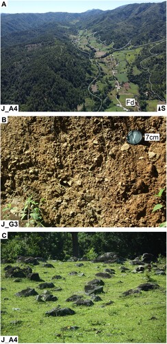
Figure 3. (A) Panoramic views of some debris flows mapped in Jarabacoa zone. (B, C) Outcrops of some interpreted debris flows in Jarabacoa zone. Letters Fd refer to debris flow. Continuous line delineates the boundaries of the debris flow. Lower left key indicates the study zone and panoramic location quadrant (MecMat maps in the Main Plate) and lower right key the panoramic orientation.
4.2% of the classified landslides are earth slide flows (SFe). These landslides are conditioned by the presence of shales with blocks (San Marcos Mélange) in Puerto Plata zone, sandstones and clays (La Toca Formation) in Santiago zone, alterites of igneous rocks and rich-matrix superficial formations in Jarabacoa zone.
The remaining 5.2% of the classified landslides are rock falls (Cr), debris slides (Sd), rock translational slide flows (STFr), debris slide flows (SFd), dry debris flows (Fdd) and debris avalanches (Ad).
5.3. Thickness
All the 5858 punctual landslides have been classified as shallow landslides and from a total of 227 areal landslides, 33.9% are shallow and 66.1% deep-seated.
5.4. Activity
Regarding the 308 classified landslides, 64.6% are inactive, 27.9% active and 7.5% relict. From a number of 227 areal landslides, 87.7% are inactive, 10.1% relict and 2.2% active.
Landslide activity can be correlated with relative age, reclassifying relict as very old and old landslides, inactive as mature landslides, and active as young and recent landslides (CitationGonzález-Díez et al., 1999; CitationKeaton & DeGraff, 1996; CitationWieczorek, 1984). However, the high density of the tropical vegetation in the study zones can make this correlation inaccurate. Thus, the high percentage of inactive landslides can be correlated with old landslides, originated in a different climate (CitationBucci et al., 2021) or be recent landslides, covered by a dense tropical vegetation.
6. Analysis of destabilizing factors
Landslides can have several destabilizing factors, including precondition, preparatory, triggering and sustaining (CitationCrozier, 1989). This understanding is beyond the scope of this paper. Hence, here the analysis will be confined to the main precondition and triggering factors.
6.1. Conditioning factors: lithology and structure
Lithology and structure are significant landslides precondition or conditioning factors. This section analyses the most significant lithologies and structures in the three zones.
6.1.1. Puerto Plata zone
In the total of 1751 landslides, 41.6% are located in marls and limestones (Villa Trina Formation) and 36.7% in shales with blocks (San Marcos Mélange) ().
Table 3. Lithology, number of landslides (Nm) and percentage (%) in Puerto Plata zone. Abbreviation C. refers to Complex.
shows different parameters of the landslides affecting the marls and limestones (Villa Trina Formation) and the shales with blocks (San Marcos Mélange).
Table 4. Parameters of the landslides affecting marls and limestones (Villa Trina Formation) and shales with blocks (San Marcos Mélange) in Puerto Plata zone. Mec: most frequent propagation mechanism, landslide percentage and more frequent thickness (shallow or deep-seated). Nmp/km2: number of punctual landslides per km2. Ama: area affected by areal landslides. Act: percentage of active landslides. Mec and Act has been calculated according to classified landslides (144 landslides), Nmp/km2 according to punctual landslides (1641 landslides) and Ama according to areal landslides (110 landslides) of .
The inspection of allows us to make the following considerations:
The marls and limestones (Villa Trina Formation) are associated to the steeper reliefs of the zone (Loma Isabel de Torres, 766 m and Loma El Brinco, 575 m), while the shales with blocks are associated to smooth reliefs (San Marcos Mélange). Thus, the carbonated Formation is interpreted as a lithology more resistant to erosion, conditioning deep-seated and more extensive slides (Mec, Ama) and less gravitational activity (Act), while the remain siliciclastic Formation is interpreted as a lithology less resistant, conditioning shallow and less extensive flows (Mec, Ama) as well as more gravitational activity (Act).
According to the stratigraphic sequence, the shales with blocks (San Marcos Mélange) underlie the marls and limestones (Villa Trina Formation). Thus, the less erosion resistance and stratigraphic position of the mainly siliciclastic lithology determine the gravitational instability of the mainly carbonated lithology.
The number of punctual landslides in both lithologies is inversely proportional to the percentage of active landslides. In this sense, the marls and limestones (Villa Trina Formation), with more erosion resistance and less gravitational activity (Act), present a better preservation and a greater number of detected landslides (NmP/km2), while the shales with blocks (San Marcos Mélange), with less erosion resistance and more gravitational activity (Act), have a poorer preservation and a smaller number of detected landslides (NmP/km2).
6.1.2. Santiago zone
In the total of 3438 landslides, 41.6% are located in marls and siltites (Altamira Formation); 38.3% in sandstones and clays (La Toca Formation) and 8.4% in marls and limestones (Villa Trina Formation) ().
Table 5. Lithology, number of landslides (Nm) and percentage (%) in Santiago zone. Abbreviations Fm. and Mb. refer to Formation and Member, respectively.
Just 1% of the inventoried landslides are located in limestones (Los Haitises Formation). On the other hand, our fieldwork has revealed this lithology in many head-landslides affecting other formations (Villa Trina and La Toca Formations).
shows different parameters of the landslides affecting the diverse lithologies.
Table 6. Parameters of the landslides affecting limestones of Los Haitises Formation (Lime.), marls and limestones of Villa Trina Formation (Marl.), sandstones and clays of La Toca Formation (Sand.) and marls and siltites of Altamira Formation (Silt.) in Santiago zone. Mec: most frequent propagation mechanism, landslide percentage and more frequent thickness (shallow or deep-seated). Nmp/km2: number of punctual landslides per km2. Ama: area affected by areal landslides. Act: percentage of active landslides. Mec and Act has been calculated according to classified landslides (119 landslides), Nmp/km2 according to punctual landslides (3354 landslides) and Ama according to areal landslides (84 landslides) of .
From , we propose:
The sandstones and clays (La Toca Formation) are associated to the smooth reliefs. Thus, this unit is interpreted as a lithology less resistant to erosion and, consequently, a conditioning lithology of more gravitational activity (Act).
According to the stratigraphic sequence, the sandstones and clays (La Toca Formation) and the marls and limestones (Villa Trina Formation) underlie the limestones (Los Haitises Formation). Thus, the less erosion resistance and the stratigraphic position of the carbonated-siliciclastic rocks determine the gravitational instability of the upper massive limestones. Consequently, in the contact between the carbonated and the siliciclastic lithologies occurs landslides, which are interpreted as deep-seated and extensive slides (Mec, Ama), with frequent boulders of Los Haitises Formation in its heads.
6.1.3. Jarabacoa zone
In the total of 896 landslides, 57.5% are located in the tonalites; 13.9% in the ultrabasic rocks and 11.3% in basalts (Pelona-Pico Duarte Formation) ().
Table 7. Lithology, number of landslides (Nm) and percentage (%) in Jarabacoa zone. Abbreviation Fm. refers to Formation.
shows different parameters of the landslides controlled by the lithology.
Table 8. Parameters of the landslides affecting the tonalites, the ultrabasic rocks and basalts of the Pelona-Pico Duarte Formation in Jarabacoa zone. Mec: most frequent propagation mechanism, landslide percentage and more frequent thickness (shallow or deep-seated). Nmp/km2: number of punctual landslides per km2. Ama: area affected by areal landslides. Act: percentage of active landslides. Mec and Act has been calculated according to classified landslides (45 landslides), Nmp/km2 according to punctual landslides (863 landslides) and Ama according to areal landslides (33 landslides) of .
Analyses of allows us to make the following considerations:
The ultrabasic rocks and the basalts of the Pelona-Pico Duarte Formation are associated to the steeper reliefs of the zone, while the tonalite intrusions are associated to both steeper and smoother reliefs in the Jarabacoa basin. Thus, the ultrabasic rocks and basalts are interpreted as lithologies more resistant to erosion and, consequently, are lithologies of less gravitational activity (Act). However, the tonalites are interpreted as a lithology less resistant and, consequently, they determine shallow flows (Mec) and a more gravitational activity (Act). The lower resistance of tonalites may be related to their frequent supergene alteration ().
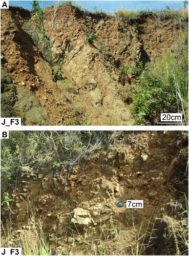
The basalts of the Pelona-Pico Duarte Formation present a highly fractured area characterized by shallow landslides, a steep relief without any associated concave uppermost part (D) and outcrops of highly fractured basalts (A), occasionally disaggregated (B), adjacent to the Bonao-La Guacara Fault Zone. These data allow interpreting this area as affected by relatively shallow landslides but with a high susceptibility to develop deep-seated landslides.
Figure 4. Alterites and fresh rock cores in the tonalites (J zone). Lower left key indicates the study zone and panoramic location quadrant (MecMat map in the Main Plate).
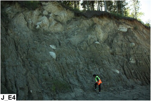
Figure 5. Outcrops basalts in the BGFZ (Jarabacoa zone): (A) fractured basalts not disaggregated and (B) fractured basalts disaggregated. Lower left key indicates the study zone and panoramic location quadrant (MecMat map in the Main Plate).
6.2. Triggering factors: rainfall and active faulting
Intense rainfall and tropical storms are main triggering factors of landslides in the northern sector of Hispaniola. These factors were proposed by CitationMuñoz et al. (2009, Citation2017) in the Carlos Díaz landslide (a deep-seated and dormant-young landslide in the Santiago zone) or by CitationSuárez Rodríguez et al. (2012) in La Vega zone (which includes the Jarabacoa study zone).
Additionally, the Camú, Septentrional and Bonao-La Guácara fault zones are morphologically characterized by rectilinear scarps with associated both deep-seated and extensive landslides. These three fault zones contain active faults and have shallow seismicity, therefore, the related scarps have been interpreted as active by CitationSuárez Rodríguez et al. (2017b; Citation2019) and CitationEscuder-Viruete et al. (2021).
Taking into account both factors, intense rainfall and earthquake shaking, the landslide inventory here elaborated can differentiate, in a first approach, which factor is more relevant.
In the total of 6085 landslides, 89% of the head-landslides are on the lowermost parts of the hillslopes and 10% on the uppermost parts ().
Table 9. Number and percentage of head-landslides on the lowermost parts of the hillslopes (Nml), on the uppermost parts (Nmu) and with no data (null) in Puerto Plata (P), Santiago (S), Jarabacoa (J) zones and in all of them (T).
The observation of allows us to establish the following considerations:
Following CitationDensmore and Hovius (2000), landslide distribution can provide information on whether bedrock landslides in mountainous regions are triggered by storms or by earthquakes. According to these authors, landslides closer to ridge crests are triggered by earthquakes and those concentrated on hillslope toes are triggered by storms. Thus, according to our map and data from , intense rainfall can be the triggering factor of the most of the landslides in the three zones (70% in P, 99% in S, 90% in J).
7. Discussion and conclusion
The compiled landslide inventory and the related database constitute an updated record of landslide activity in three selected zones of the Dominican Republic: Puerto Plata, Santiago and Jarabacoa.
The combined photo-interpretation of satellite imagery and fieldwork made possible to detect 6085 landslides, 5858 punctual and 227 areal. Areal landslides affect the 16.1% of the area of the whole zones, corresponding to 20.0% in Santiago, 17.5% in Puerto Plata and 10.0% in Jarabacoa. The fieldwork campaign carried out in October–November of 2021 allowed to revise or identify 154 landslides, of which 81 are punctual and 73 areal.
The analysis of 308 classified landslides shows that shallow flows mainly affect to units less resistant to erosion. These units include the shales with blocks (San Marcos Mélange) in Puerto Plata zone; the tonalites intrusions (and related alterites) in Jarabacoa zone; and the sandstones and clays (La Toca Formation) and marls and siltites (Altamira Formation) in Santiago zone (see ).
The deep-seated and extensive slides mainly affect to units that are more resistant to erosion and the lithological contact between more resistant rocks overlying less resistant rocks. Typically, these contacts are the marls and limestones (Villa Trina Formation) overlying the shales with blocks (San Marcos Mélange) in Puerto Plata zone; the limestones (Los Haitíses Formation) overlying the sandstones and clays (La Toca Formation) or marls and limestones (Villa Trina Formation) in Santiago zone; and the basalts (Pelona-Pico Duarte Formation) and the ultrabasic unit in Jarabacoa zone.
Rainfall is proposed as the first triggering factor over the active faulting, as indicate that 89% of the head-landslides are concentrated on hillslope toes and the 10% closer to ridge crests.
The higher percentage of landslide in Santiago zone (56.5% of the total landslides) stands out, compared to Puerto Plata zone (28.8%) and Jarabacoa zone (14.7%). The reasons for this difference may include the higher susceptibility to landslides of the marls and siltites of Altamira Formation (23.5% of the total landslides) and the sandstones and clays of La Toca Formation (21.6%). Future work should analyse the fault activity and the fluvio-gravitational evolution of the Septentrional Fault Zone in Santiago zone, comparing it with the Camú Fault Zone in Puerto Plata zone and the Bonao-La Guácara Fault Zone in Jarabacoa zone.
Software
We used Google Earth© (http://earth.google.com) for the visualisation of the landslides and ESRI ArcGIS 10.8 version to digitally organise and analyse the data, to use the Digital Terrain Model (LandInfo, USA), and to assemble the final map for publication and graphical editing.
230830_Inventory_Map_revised.pdf
Download PDF (14.8 MB)Data availability statement
The data that support the findings of this study are available from the corresponding author, AR, upon reasonable request.
Authors contribution
AR and AS made the photointerpretation and the landslide inventory maps; AR, AS, YP and YB performed the fieldwork; AR coded the information in a GIS (ArcMap 1.8); AR and AS wrote the text and prepared the figures; LG checked the text and figures; JE performed the structural and tectonic data; and JE and MB lead the research project.
Acknowledgements
We would like to thank the MESCyT of the Dominican Republic Government for supporting this research through FONDOCYT Project 2018-19-1A4-008. This project was developed under the Institutional Cooperation Agreement between the Servicio Geológico Nacional of the Dominican Republic (SGN) and the Instituto Geológico y Minero de España (IGMECSIC). The research was also funded through PID2019-105625RB-C22 Project of the MCIN/AEI/10.13039/501100011033 of the Spanish Government. The authors thank Dr. Lun-Wei Wei, Dr. Yi-Chiung Chao, Dr. Cecilia Furlan and Dr. Mike J. Smith (editor) for their critical comments and suggestions, which greatly improved the quality of our manuscript and map.
Disclosure statement
No potential conflict of interest was reported by the author(s).
References
- Álvarez Muñoz, E. (2004). Filosofía de las ciencias de la tierra. El cierre categorial de la geología. Pentalfa Ediciones, 355 pp.
- Bucci, F., Santangelo, M., Fiorucci, F., Ardizzone, F., Giordan, D., Cignetti, M., Notti, D., Allasia, P., Godone, D., Lagomarsin, D., Pozzoli, A., Norelli, E., & Cardinali, M. (2021). Geomorphologic landslide inventory by air photo interpretation of the High Agri Valley (Southern Italy). Journal of Maps, 17(2), 376–388. https://doi.org/10.1080/17445647.2021.1943552
- Crozier, M. J. (1989). Landslides: Causes, consequences and environment. Routledge.
- Cruden, D. M., & Varnes, D. J. (1996). Landslides types and processes. In A. K. Turner & R. L. Schuster (Eds.), Landslides: Investigation and mitigation (pp. 36–75). U.S. National Academy of Sciences, Transportation Research Board, Special Report 247, Chapter 3.
- Densmore, A. L., & Hovius, N. (2000). Topographic fingerprints of bedrock landslides. Geology, 28(4), 371–374. https://doi.org/10.1130/0091-7613(2000)28<371:TFOBL>2.0.CO;2
- de Zoeten, R., & Mann, P. (1991). Structural geology and cenozoic tectonic history of the central Cordillera septentrional, Dominican republic. In P. Mann, G. Draper, & J. F. Lewis (Eds.), Geologic and tectonic development of the North America- Caribbean plate boundary in Hispaniola (pp. 265–279). Geological Society of America Special Paper 262.
- Dolan, J. F., Mullins, H. T., & Wald, D. J. (1998). Active tectonics of the north-central Caribbean region: Oblique collision, strain partitioning and opposing slabs. In J. Dolan, & P. Mann (Eds.), Active strike-slip and collisional tectonics of the northern Caribbean plate boundary in Hispaniola (pp. 1–61). Geological Society America Special Paper 326.
- Escuder-Viruete, J. (2011). Mapa geológico de la república dominicana a E. 1:50.000 de la hoja N° 6073-II (jarabacoa). proyecto SYSMIN de cartografía geotemática de la república dominicana. Programa Dirección General de Minería.
- Escuder-Viruete, J., & Pérez, Y. (2020). Neotectonic structures and stress fields associated with oblique collision and forearc sliver formation in northern Hispaniola: Implications for the seismic hazard assessment. Tectonophysics, 784, 228452. https://doi.org/10.1016/j.tecto.2020.228452
- Escuder-Viruete, J., Pérez, Y., Suárez-Rodríguez, A., García-Senz, J., Betania Roque, M., & Calzadilla, M. (2021). Geodinámica y Neotectónica de la Cordillera Septentrional y Península de Samaná, República Dominicana: implicaciones sismotectónicas y para la evaluación de la amenaza sísmica. Geodynamics and Neotectonics of the Cordillera Septentrional and Samaná Peninsula, Dominican Republic: implications for seismotectonics and seismic hazard assessment. Boletín Geológico y Minero de España, 132(4), 439–464. ISSN: 0366-0176. https://doi.org/10.21701/bolgeomin.132.4.005
- Escuer Solé, J. (2010a). Mapa Geomorfológico y Mapa de Procesos Activos susceptibles de constituir Riesgo Geológico a escala de 1:100.000 de la Hoja de Puerto Plata (N° 6075) de la República Dominicana. Proyecto de Cartografía Geotemática de la República Dominicana-Programa SYSMIN II (9 ACP DO 006) Ref. EuropeAid/122430/D/SER/DO. Madrid- Santo Domingo.
- Escuer Solé, J. (2010b). Mapa Geomorfológico y Mapa de Procesos Activos susceptibles de constituir Riesgo Geológico a escala de 1:100.000 de la Hoja de Santiago de los Caballeros (N° 6074) de la República Dominicana. Proyecto de Cartografía Geotemática de la República Dominicana-Programa SYSMIN II (9 ACP DO 006) Ref. EuropeAid/122430/D/SER/DO. Madrid- Santo Domingo.
- Evans, S. G., & Hungr, O. (1993). The assessment of rockfall hazards at the base of talus slopes. Canadian Geotechnical Journal, 30(4), 620–636. https://doi.org/10.1139/t93-054
- González-Díez, A., Remondo, J., Diaz de Teran, J., & Cendrero, A. (1999). A methodological approach for the analysis of the temporal occurrence and triggering factors of landslides. Geomorphology, 30(1-2), 95–113. https://doi.org/10.1016/S0169-555X(99)00047-1
- Haque, U., da Silva, P. F., Devoli, G., Pilz, J., Zhao, B., Khaloua, A., Wilopo, W., Andersen, P., Lu, P., Lee, J., Yamamoto, T., Keellings, D., Wu, J., & Glass, G. E. (2019). The human cost of global warming: Deadly landslides and their triggers (1995–2014). The Science of the Total Environment, 682, 673–684. https://doi.org/10.1016/j.scitotenv.2019.03.415
- Hernáiz Huerta, P. P. (2010). Mapa geológico de la República Dominicana a escala 1:50.000 de la Hoja n° 6075-III (Imbert) (EuropeAid/122430/D/SER/DO). IGME. Proyecto SYSMIN II.
- Hungr, O., Leroueil, S., & Picarelli, L. (2014). The Varnes classification of landslide types, an update. Landslides, 11(2), 167–194. https://doi.org/10.1007/s10346-013-0436-y
- Joubert, M. (2011). Mapa Geológico de la República Dominicana a E. 1:50.000 de la Hoja N° 6073-III (Manabao). Proyecto SYSMIN de Cartografía Geotemática de la República Dominicana. Programa Dirección General de Minería.
- Keaton, J. R., & DeGraff, J. V. (1996). Surface observation and geologic mapping. In A. K. Turner & R. L. Schuster (Eds.), Landslides: Investigation and mitigation (pp. 178–230). U.S. National Academy of Sciences, Transportation Research Board, Special Report 247, Chapter 9.
- Mann, P., Draper, G., & Lewis, J. F. (1991). An overview of the geologic and tectonic development of hispaniola. In P. Mann, G. Draper, & J. F. Lewis (Eds.), Geologic and Tectonic Development of the North America-Caribbean Plate Boundary in Hispaniola (pp. 1–28). Geological Society of America Special Paper 262.
- Mann, P., Prentice, C. S., Burr, G., Peña, L. R., & Taylor, F. W. (1998). Tectonic geomorphology and paleoseismology of the Septentrional fault system, Dominican Republic. Geological Society of America Special Papers, 326, 63–123. DOI: 10.1130/0-8137-2326-4.63
- Mann, P., Taylor, F. W., Edwards, R. L., & Ku, T. L. (1995). Actively evolving microplate formation by oblique collision and sideways motion along strike-slip faults: An example from the northeastern Caribbean plate margin. Tectonophysics, 246(1–3), 1–69. https://doi.org/10.1016/0040-1951(94)00268-E
- Monthel, J. (2010). Mapa geológico de la República Dominicana a escala 1:50.000 de la Hoja n° 6075-II (Puerto Plata). (EuropeAid/122430/D/SER/DO). IGME. Proyecto SYSMIN II.
- Muñoz, S., Calzadilla, M., & Comas, M. (2009). Informe correspondiente a la evaluación técnica realizada a los Deslizamientos ocurridos en el poblado Carlos Díaz, Tamboril y a los poblados de Palo Quemado, La Cumbre de Juan Veras y al Parador Don Pedro, ubicados en la Carretera Turística de Santiago-Puerto Plata. SGN, 17 pp.
- Muñoz, S., Calzadilla, M., Suardí, J. A., Betania, M., Rodríguez, Y., Pérez, Y., Bautista, J. P., Ramírez, A., Clases, S. J., Rosario, G., Guzmán, V., Medoza, F., Vargas, J., Mejía, W., & Díaz, M. (2017). Prevención y Manejo de Desastres de Deslizamiento y eventos relacionados, con participación comunitaria, en el Municipio de Tamboril, (Carlos Díaz y Amaceyes), Provincia Santiago, Republica Dominicana. SGN, 249 pp.
- Neall, V. E. (2004). Hyperconcentrated flow. In A. S. Goudie (Ed.), Encyclopedia of geomorphology (pp. 542). Routledge.
- Oficina Nacional de Estadística. (2012). IX Censo Nacional de Población y Vivienda 2010. Informe General. Volumen I.
- Pérez-Estaún, A., Hernáiz Huerta, P., Lopera, E., Joubert, M., Sysmin, G., Escuder-Viruete, J., Diaz De Neira, A., Monthel, J., García-Senz, J., Ubrien, P., Contreras, P., Bernárdez, E., Stein, G., Deschamps, I., García-Lobón, J. L., & Ayala, C. (2007). Geología de la República Dominicana: de la construcción de arco-isla a la colisión arco-continente. Boletín Geológico y Minero, 188(2), 157–174.
- Pindell, J. L., & Draper, G. (1991). Stratigraphy and geological history of the Puerto Plata area, Northern Dominican Republic. In P. Mann, G. Draper, & J. F. Lewis (Eds.), Geologic and tectonic development of the North America-Caribeann Plate Boundary in Hispaniola (pp. 97–114). Geological Society of America, Special Paper 262.
- Ramírez Merino, J. I. (2010). Mapa Geológico de la República Dominicana a E. 1:50.000 de la Hoja N° 6074-I (San Francisco Arriba). Proyecto SYSMIN de Cartografía Geotemática de la República Dominicana. Programa Dirección General de Minería.
- Roopnarine, R., Maharaj, A., & Deonarine, S. (2020). Evaluaciones de riesgo de inundaciones y deslizamiento en República Dominicana informadas por las proyecciones de precipitaciones. Informe técnico. Global Water Partnership, 83 pp.
- Suárez Rodríguez, A. (2011). Mapa Geomorfológico y Mapa de Procesos Activos susceptibles de constituir Riesgo Geológico a escala de 1: 100.000 de la Hoja de La Vega (N° 6073) de la República Dominicana. Proyecto de Cartografía Geotemática de la República Dominicana-Programa SYSMIN II (9 ACP DO 006) Ref. EuropeAid/122430/D/SER/DO. Madrid- Santo Domingo.
- Suárez-Rodríguez, A., Escuder-Viruete, J., & Colmenero-Hidalgo, E. (2017a). La mélange de San Marcos, Cordillera Septentrional de la República Dominicana. Significado, origen y edad. Boletín Geológico y Minero, 128(3), 633–656. ISSN: 0366-0176 https://doi.org/10.21701/bolgeomin.128.3.006
- Suárez Rodríguez, A., Escuder-Viruete, J., García-Senz, J., Navas Madrazo, J., Rodríguez García, A., Calzadilla, M., & Pérez, Y. (2017b). Actividad tectónica en la Cordillera Septentrional (N, República Dominicana): Indicadores geomorfológicos y análisis del patrón de la red de drenaje. Resúmenes 1er. Congreso Internacional de Geología Aplicada.
- Suárez Rodríguez, A., García Senz, J., Escuder-Viruete, J., Rodríguez García, A., Pérez, Y., & Calzadilla, M. (2019). Geomorfología tectónica en el “Bloque de Esperanza” (Cuenca del Cibao occidental, Norte de la República Dominicana). 2do. Congreso Internacional de Geología Aplicada, R. Dominicana. (on line: www.sodogeo.org)
- Suárez Rodríguez, A., Rodríguez García, A., Mink, S. M., González Menéndez, L., & Escuder-Viruete, J. (2012).: Movimientos en masa en ambientes tectónicos activos: Origen climático vs. sísmico (República Dominicana, Placa del Caribe). Geo-Temas, 13, 4. ISSN: 1576-5172. VIII Congreso Geológico de España. SGE.
- Symithe, S., Calais, E., de Chabalier, J. B., Robertson, R., & Higgins, M. (2015). Current block motions and strain accumulation on active faults in the Caribbean. Journal of Geophysical Research: Solid Earth, 120(5), 3748–3774. https://doi.org/10.1002/2014JB011779
- Urien, P. (2011). Mapa Geológico de la República Dominicana a E. 1:50.000 de la Hoja N° 6074-II (Santiago de los Caballeros). Proyecto SYSMIN de Cartografía Geotemática de la República Dominicana. Programa Dirección General de Minería.
- van Westen, C. J., Castellanos, E., & Kuriakose, S. L. (2008). Spatial data for landslide susceptibility, hazard, and vulnerability assessment: An overview. Engineering Geology, 102(3–4), 112–131. https://doi.org/10.1016/j.enggeo.2008.03.010
- Wieczorek, G. F. (1984). Preparing a detailed landslide-inventory map for hazard evaluation and reduction. Bulletin of the Association of Engineering Geologists, 21(3), 337–342.