
ABSTRACT
The MaGIC project (Marine Geohazard along the Italian Coasts) had the aim of mapping the geohazard in the Italian seas and resulted in numerous maps. In this paper, we present the maps: ‘Maps of Geohazard features of the eastern Sardinian Margin’. The Eastern Sardinia margin has mainly a narrow shelf, which reaches a width of 20 km only to the north. At the base-of-slope, a series of intra-slope basins sits in the structural depressions formed during the opening of the Tyrrhenian back-arc system. Submerged, coastal depositional bodies are present in the Olbia area where the continental shelf is large. They most likely represent the remnants of coastal environments formed during the last rise in sea level. They can represent important geo-resources for application in the issue of coastal erosion management. They are also the site of ecosystems hosting a specific biodiversity, which need to be preserved. In the central and southern part of the mapped area, the shelf is very narrow with an average width of about 4 km. Here, many canyon heads are very close to the coastline. They develop through retrogadational processes. Particularly in those canyons, where the canyon heads reach the coast, sediment instability represents an important source of geohazards to the coastal regions.
1. Introduction
Our article complements the ‘Maps of Geohazard features of the eastern Sardinian Margin’, produced in the frame of the MaGIC project (Marine Geohazard along the Italian Coasts). The latter was a large coordinated effort which involved the whole marine geological community in Italy in the years 2007–2013. The maps result from the interpretation of multibeam bathymetric data acquired during various cruises. As such, in the maps, the hazard reconstructions result from the interpretation of the seafloor morphology and of the shallow and immediate sub-surface elements. Two levels of interpretation are presented: the map of the Physiographic Domain at 1:250000 scale and the map of the Morphological Units and Morpho-bathymetric Elements (areas and vectors respectively) at 1:100000 scale.
2. Study area: the Eastern Sardinia margin
The eastern Sardinia margin is the submerged portion of the Sardo-Corso continental block, mainly made up of crystalline and metamorphic rocks deformed during the Ercinian orogenesis (CitationCarmignani et al., 2001). Following the Ercinian orogenic event, during the Mesozoic and the first part of the Tertiary, the Sardo-Corso block represented the southern part of the European Plate and was in part affected by the Alpine orogenesis. Successively, the Sardo-Corso block was involved in extensional and strike-slip tectonics linked to its counter-clockwise rotation and its separation from southern Europe, due to the opening of the Balearic Basin. Finally, further extensional and strike-slip tectonics affected the Sardo-Corso block during the opening of the Tyrrhenian Basin (CitationKastens & Mascle, 1990; CitationLoreto et al., 2020; CitationMarani & Gamberi, 2004b; CitationMoeller et al., 2013; CitationPalmiotto & Loreto, 2019; CitationPrada et al., 2014). Based on the drilling results of ODP leg 107, the beginning of this last tectonic activity has been dated to the Mid-Upper Miocene (Tortonian 11 Ma). However, since undated conglomerates form the base of the drilled sequence, an older age of inception of the activity cannot be excluded.
Following the extensional tectonics that led to the opening of the Tyrrhenian Sea, the eastern margin of the Sardo-Corso Block began to behave as a passive margin. Volcanic products related to the last tectonic activity are found along the eastern coastal areas and in its offshore, in particular close to Orosei (CitationLustrino et al., 2013; CitationOrrù & Ulzega, 1987). Due to its passive margin geodynamic setting, the eastern Sardinian area suffers negligible seismicity and reduced vertical movements.
The large-scale physiography of the eastern Sardinia margin is mainly a heritage of the rifting episode that caused the opening of the Tyrrhenian Sea. The extent of the continental shelf decreases from the North, where it is about 25-km-wide, to the South, where it is only 7-km-large (a). The shelf break is in general located at about 125 m water depth. In some areas, where submarine canyons have their heads very close to the present-day coastline, such as in the area of the Orosei Gulf, Capo Bellavista, Capo Ferratu and Porto Santoru, the continental shelf is almost, or totally absent (CitationGamberi, 2020) (a). Towards the North, the coastline presents promontories and bays with several islands and islets. In this region, the continental shelf has mainly a relict morphology consisting of geomorphic elements formed during previous stages of lower sea level, particularly during the last transgression (CitationGamberi, 2020).
Figure 1. (A) Shaded relief map from multibeam bathymetric data of the eastern Sardinian margin. The continental shelf is in general narrow. Numerous canyons are present in the slope and feed deep-sea fans in the intra-slope basins. The latter are bounded seaward by structural highs. (B) Schematic cross-section illustrating the structural and stratigraphic setting of the eastern Sardinia margin down to the Vavilov back-arc area (location in a; the eastern part of the map lies outside from the map of a). Note the staircase of basin formed in extensional structural troughs. (C) Sesimic line BC44 showing the structures of the Olbia Basin, the most northern intraslope basin in the Sardinia margin (location in a). The purple line marks the base of the Plio-Quaternary succession.
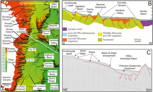
As a result of the horst and graben and semi-graben structures formed during the last extensional tectonics, the continental slope is topographically complex, with a series of physiographic domains with increasing depth going westward (CitationGamberi & Dalla Valle, 2009; CitationMarani & Gamberi, 2004a) (a–c).
The first domain includes the upper slope and the Olbia, Baronie, Ogliastra and Sarrabus upper intra-slope basins (CitationGamberi & Dalla Valle, 2009; CitationGamberi & Marani, 2004) (a). In the upper slope, several submarine canyons are present and often connect with leveed channels further downslope (CitationDalla Valle & Gamberi, 2010, Citation2011; CitationGamberi, 2020) (a). Areas with pockmarks and other evidences of fluid circulation are particularly evident in the northern slope, where they are also associated with seafloor instability (CitationDalla Valle & Gamberi, 2011). In the intra-slope basins, turbidity currents form both transverse and axial deep-sea fans composed of leveed channels and frontal splays (CitationDalla Valle & Gamberi, 2011b; CitationGamberi & Marani, 2004) (a).
The upper intra-slope basins are bounded seaward by the structural highs (CitationMarani & Gamberi, 2004a) of the Quirra ridge, the Baronie Seamount and the Etruschi seamount (a–c). The Sardinia Valley, connected to the Sarrabus and the Orosei canyons, crosses the Cornaglia Terrace (a) and reaches the Vavilov back-arc Basin located further east at 3000 m depth (CitationGamberi & Marani, 2004; CitationGamberi & Marani, 2009).
3. Methods and software
As the maps were produced using the specific interpretative and cartographic standard used in the MAGIC project, the procedure is described in detail in Ridente and Chiocci (this volume). The legend of the Physiographic Domain map is present on the map, while the legend of the Morphological Units and Morpho-bathymetric Elements maps is presented as a separate table. Global mapper and IHS Kingdom suite were used for bathymetric and seismic data visualization and interpretation.
4. Maps of morphologic units and morpho-bathymetric elements
4.1. Tavolara area (MaGIC sheet 55)
The Sheet 55 ‘Tavolara’ covers the western part of the Olbia Basin, an intra-slope basin located in the northern sector of the eastern Sardinian margin (a and c). It mostly comprehends the northern Sardinian continental shelf, which reaches here its maximum width of 25 km. The continental shelf becomes narrow southward, where it has an extent of 13 km. The edge of the continental shelf is located at 120 m depth. Numerous canyon heads indent the shelf-break (a); in the southern part of the sheet, some of them form the large Posada Canyon amphitheatre, which enlarges landward, reaching a length parallel to the margin of 22 km (a). The continental shelf of the Olbia Basin displays relict morphologic features, actually submerged below the sea level (CitationGamberi, 2020) (a). Small incised valleys are the remnants of ancient rivers that crossed the shelf during the last lowstand of sea level. Relics of fossil deltaic systems are also present. In some cases, the river systems are at the edge of the continental shelf, indicating that they were active during the peak of the last glaciation, and discharged sediments directly in the continental slope (CitationGamberi, 2020).
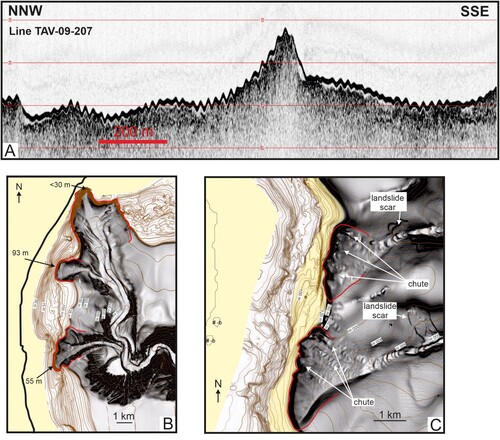
Figure 2. (A) Subbottom Chirp profile in the southern part of the Tavolara sheet. The central high corresponds to a submerged coastal feature formed presumably during the last sea-level rise (see location in a). (B) Shaded relief from multibeam bathymetric data of the Gonone canyon system (see location in a). Landslides scars are ubiquitous along the canyon headwalls and flanks. Chutes are also present. Seafloor undulation in the most southern canyon is of the ‘cyclic step’ type. Inner thalwegs leave erosional terraces on the main axis of the canyon. (C) The Santa Maria Navarrese canyons (see location in a). The canyon heads show landsliding and gullying that form indentation in the shelf edge. Landslide blocks are present in the canyon heads, and landslide also affects the flank of the canyons. Cyclic steps form in the lower part of both canyons.
Between Porto Cervo and Golfo Aranci, and in the shelf sector landward from the Posada Canyon, submerged relict features, such as paleo-sand spits, -barrier islands, -lagoons, -estuaries and -tidal basins are present (a). The main submerged barrier-island systems, located between Porto Cervo and Golfo Aranci, show both arcuate and straight forms, and are 10- and 8-km-long. Some minor paleo-barrier islands are also present north from the Island of Tavolara, while others are present in the outer sector of the shelf. In the outer shelf, a series of morphological steps, submerged between 120 and 100 m depth, are present; they may represent the morphological expression of ancient coastlines not reworked by the processes connected with the last sea level rise.
Numerous canyon heads indent the continental shelf of the Olbia Basin (a). The Posada Canyon System is the largest and affects the shelf through a network of canyons, incised more than 700 m with respect to the surrounding seafloor (CitationGamberi & Dalla Valle, 2009). The Molara and Tavolara Canyons are further elements which form erosional structure in the outer part of the shelf (CitationGamberi, 2020) (a).
4.2. Orosei area (MaGIC sheet 56)
The Sheet 56 ‘Orosei’ is located in the central sector of the eastern Sardinia margin. It includes the continental shelf, the continental slope and, in its southeastern corner a very small portion of the plain of the Baronie intra-slope basin, which is located at more than 1500 m depth.
The continental shelf reaches its maximum width to the North (20 km) and significantly narrows southward where it disappears in the Gulf of Orosei (a). The latter is dominated by the apical part of the main submarine drainage system of the Sardinian margin, composed by the Ginepro, Gonone and Orosei Canyons (CitationGamberi & Dalla Valle, 2009; CitationGamberi & Marani, 2004) (b). The three submarine canyons indent the continental shelf, reaching, in the case of the head of the Gonone Canyon, a distance of less than 1 km from the coastline. In the continental shelf they span a total width of 13 km and joining downslope, originate a single, main conduit that further downslope becomes the Sardinia Valley (a). The flanks of both the Gonone and Orosei canyons are highly asymmetric and steep, and scoured by numerous erosional gullies, which are responsible for their extremely rugged morphology (b).
In the canyon flanks, various headwall scars of shallow-seated landslides are also evident and witness a widespread instability of the canyon walls. The related landslide bodies form sometimes convex-up, mounded bodies in the floor of the canyons. These morphologies, in addition to train of bedforms and incised thalwegs flanked by erosional terraces along the canyon axis, are suggestive of a significant recent sedimentary activity, with a mainly erosional character, which in some cases could be still on-going. Along the shelf edge, separating the head of the Gonone and Orosei Canyons, a submerged, extinguished volcanic center is present (CitationOrrù & Ulzega, 1987). The volcanic center is composed of two circular edifices that rise approximately 60 m from the surrounding seafloor, reaching a minimum water depth of 40 m. The two volcanic edifices cover a total area of 3 km2 and, in their shallower parts, show a flat summit.
4.3. Arbatax area (MaGIC sheet 57)
The Sheet 57 ‘Arbatax’, located southward from the Gulf of Orosei, covers the northern part of the Ogliastra intra-slope basin, formed in a graben originated by the rotation of crustal blocks along listric faults during the opening of the Tyrrhenian Sea (CitationMarani & Gamberi, 2004a) (a). It covers the continental shelf, the continental slope and the plain of the Ogliastra Intraslope Basin, which, at 1750m depth, contains the deepest point of the whole system of intra-slope basins of the Sardinian margin.
The continental shelf shows the ‘classical’ arrangement of the Sardinian margin, being very narrow, never larger than 10 km, and indented by several submarine canyons. The Arbatax Canyon has its head very close to the coast, where the industrial harbour of Arbatax is located. The Marina di Gairo, the Bari Sardo and the Santa Maria Navarrese are the other main canyons. At the base of the continental slope, the Arbatax canyon connects, to a submarine deep-sea fan, consisting proximally of a sinuous S-SE directed leveed-channel. The deep-sea fan has an area of 170 km2 and stands 120 m above the surrounding seafloor. On the deep-sea-fan surface, different systems of abandoned channels show that avulsion and meander cut-off processes are a common tract of the submarine channels in this margin. Channels frequently respond to autocyclic processes, guided by compensational deposition and migrate leaving abandoned tracts. Compensational stacking of depositional bodies in the Arbatax deep-sea fan is also indicated by the presence of both active and inactive frontal splays.
To the north, the canyons of the Santa Maria Navarrese system are narrow and straight, and are characterized by a length ranging between 10 and 15 km (c). They indent only the edge of the continental shelf and are developed within a large erosional amphitheatre involving the continental slope where, landslide scars, slumps and erosional incisions are evident (c). Taking into account the widespread evidence of seafloor instability, it can be assumed that canyons of the Santa Maria Navarrese system represent an embryonic stage in the evolution of canyons. As they do not face large rivers, their formation is most likely connected with mass-wasting phenomena affecting the continental slope.
4.4. Costa Rei area (MaGIC sheet 58)
The Sheet 58 ‘Costa Rei’ is located between the Ogliastra and Ichnusa-Sarrabus intra-slope basins, in the southern sector of the eastern Sardinia margin (CitationMarani & Gamberi, 2004a) (a). The two intra-slope basins form in the N–S-trending tectonic depressions (graben), which originated during the crustal stretching that led to the opening of the Tyrrhenian Basin in the Upper Miocene (CitationKastens & Mascle, 1990). The two intra-slope basins are separated by the San Lorenzo structural high, stretching in the SW–NE direction.
The continental margin is the site of numerous submarine canyons. To the north, the Pelau Canyon reaches 2 km from the coastline and presents a rather narrow incisional head area (a).
The Flumendosa and the Sarrabus are the main canyons and together form a 20-km-long embayment of erosional origin in the southern part of the continental shelf. The Sarrabus and Flumendosa canyons show a sinuous pathway, due to the influence of the San Lorenzo High and to the frequent avulsion episodes.
The head of the Sarrabus Canyon is close to the coastline (less than 2 km of distance). The significant retreat of the heads of the canyons in this sector of the margin is likely correlated with the presence of the mouth of the Flumendosa River, the main river of Sardinia with an average annual discharge of 22 m³s−1 and an hydrographic basin of 1775 km². The large amount of sediment transported by the river is probably responsible for the large deep sea fan (San Lorenzo Fan) at the base of the slope, which covers about 500 km2 of the basin plain.
The fan is dominated by a channel-levee system, composed by the Flumendosa and Sarrabus channels, whose shape and size are controlled by the San Lorenzo High. The San Lorenzo Fan is composed of different generations of submarine channels and levees showing that its construction occurred through an alternation of erosional and depositional phases. The recent evolution of the fan consists in a straightening of the channel path, in the formation of incisional channels and thalwegs, and the development of scours and terraces along the channel flanks; it is the evidence that a recent erosional phase is still affecting the depositional system. Moreover, mass movement processes, such as landslides and slumps, further contribute to the recent incision of the channel.
5. Conclusion
The eastern Sardinian margin has generally a very narrow shelf. Only to the north the continental shelf has a width up to 25 km. Here, due to the lack or to the very reduced thickness of the Holcene high-stand wedge, past landscapes, crop out. The latter formed presumably during the last sea level rise and consists of paleo-coastal systems now submerged. They are particularly well preserved, possibly indicating that they suffered early cementation resulting in beach rock formation. Such an evolution has been shown for similar morphologic elements in the western continental shelf of the Sardinia Island. They are an important record of the variability of transgressive coastal environments and give hints on how shallow-water depositional systems respond to sea-level rise and can furnish important data to reconstruct the phases of the last sea-level rise and their connection to climate changes. Furthermore the transgressive bodies can represent sources for material, which can be used to mitigate the impact of coastal erosion in the nearby areas. However they and the other numerous rocky outcrops at the seafloor can also represent element of hazards for the installation of offshore infrastractures.
A network of closely spaced canyons dissects the continental slope; often, their heads show important landslide features. In many cases, the retrogradation of the canyon heads indicates that instability processes migrate landwards. Therefore, canyon-heads that are close to the coastal areas, such as the Gonone-Orosei Canyon System and the Arbatax and the Pelau Canyons, represent an important element of geohazard, which can impact the adjacent on-land areas. Canyons connect downslope with submarine channels that originate both transverse and longitudinal turbidite depositional systems in the intra-slope basins. The character of the structural sills that bound the intraslope basins seaward is the main control on the erosional or depositional behaviour of the sediment-gravity flows that occur in the basins.
Software
Global mapper and IHS Kingdom suite were used for bathymetric and seismic data visualization and interpretation.
14GF the Eastern Sardinia marginGamberi.pdf
Download PDF (32.7 MB)Acknowledgements
We thank officers and crews of R/V Urania and Maria Grazia (CNR), R/V Universitatis (Conisma) and R/V Explora (OGS) that acquired the data.
Disclosure statement
No potential conflict of interest was reported by the author(s).
Data availability statement
Data will be made available by the Authors upon reasonable requests.
Additional information
Funding
References
- Carmignani, L., Oggiano, G., Barca, S., Conti, P., Salvadori, I., Eltrudis, A., Funedda, A., & Pasci, S. (2001). Geologia della Sardegna (note illustrative della carta geologica della Sardegna in scala 1:200000). Memorie descrittive della carta geologica d’Italia, 60, 1–283.
- Dalla Valle, G., & Gamberi, F. (2010). Erosional sculpting of the Caprera confined deep-sea fan as a result of distal basin-spilling processes (eastern Sardinian margin, Tyrrhenian Sea). Marine Geology, 268(1–4), 55–66. https://doi.org/10.1016/j.margeo.2009.10.012
- Dalla Valle, G., & Gamberi, F. (2011). Slope channel formation, evolution and backfilling in a wide shelf, passive continental margin (Northeastern Sardinia slope, Central Tyrrhenian Sea). Marine Geology, 286(1–4), 95–105. https://doi.org/10.1016/j.margeo.2011.06.005
- Gamberi, F. (2020). Systems supplying sediment to canyon heads (SSSCHs) in the Tyrrhenian Sea: The past and the present as a key to understanding deep-sea stratigraphy. Marine and Petroleum Geology, 119 , 104470 . https://doi.org/10.1016/j.marpetgeo.2020.104470
- Gamberi, F., & Dalla Valle, G. (2009). The impact of margin-shaping processes on the architecture of the Sardinian and Sicilian margin submarine depositional systems within the Tyrrhenian Sea. In B. Kneller, O. J. Martinsen, & B. McCaffrey (Eds.), External controls on deep-water depositional systems (pp. 92, 207–219). Society for sedimentary geology, Special Publication.
- Gamberi, F., & Marani, M. (2004). Deep-sea depositional system of the Tyrrhenian Basin. Memorie Descrittive della Carta Geologica d’Italia, 44, 127–146.
- Gamberi, F., & Marani, M. (2009). Control of regional geology on the style of basin-plain depositional systems in the Tyrrhenian sea. In B. Kneller, O. J. Martinsen, & B. McCaffrey (Eds.), External controls on deep-water depositional systems (pp. 92, 221–232). Society for sedimentary geology, Special Publication.
- Kastens, K. A., & Mascle, J. (1990). The geological evolution of the Tyrrhenian Sea: An introduction to the scientific results of ODP Leg 107. In Proceedings of the Ocean Drilling Program, Scientific Results (Vol. 107, No. 3, p. 26). College Station, TX (Ocean Drilling Program).
- Loreto, M. F., Zitellini, N., Ranero, C. R., Palmiotto, C., & Prada, M. (2020). Extensional tectonics during the Tyrrhenian back-arc basin formation and a new morpho-tectonic map. Basin Research, 33, 1239–1252. https://doi.org/10.1111/bre.12458
- Lustrino, M., Fedele, L., Melluso, L., Ronga, F., Geldemacher, J., Duggen, S., Agostini, S., Cucciniello, C., Franciosi, L., & Meisel, T. (2013). Origin and evolution of Cenozoic magmatism of Sardinia (Italy). A combined isotopic (Sr–Nd–Pb–O–Hf–Os) and petrological view. Lithos, 180–181, 138–158. https://doi.org/10.1016/j.lithos.2013.08.022
- Marani, M. P., & Gamberi, F. (2004a). Structural framework of the Tyrrhenian Sea unveiled by seafloor morphology. Memorie Descrittive della Carta Geologica d'Italia, 54, 97–107.
- Marani, M. P., & Gamberi, F. (2004b). Distribution and nature of submarine volcanic landforms in the Tyrrhenian Sea: The arc vs the back-arc. In M. P. Marani, F. Gamberi, & E. Bonatti (Eds.), From seafloor to deep mantle: Architecture of the Tyrrhenian backarc basin (pp. 44, 1–2). APAT, Memorie Descrittive della Carta Geologica d'Italia.
- Moeller, S., Grevemeyer, I., Ranero, C. R., Berndt, C., Klaeschen, D., Sallares, V., Zitellini, N., & De Franco, R. (2013). Early-stage rifting of the northern Tyrrhenian Sea Basin: Results from a combined wide-angle and multichannel seismic study. Geochemistry, Geophysics, Geosystems, 14(8), 3032–3052. https://doi.org/10.1002/ggge.20180
- Orrù, P., & Ulzega, A. (1987). Rilevamento geomorfologico costiero e sottomarino applicato alla definizione delle risorse ambientali (Golfo di Orosei, Sardegna orientale). Memorie della Società Geologica Italiana, 37(2), 471–479.
- Palmiotto, C., & Loreto, M. F. (2019). Regional scale morphological pattern of the Tyrrhenian Sea: New insights from EMODnet bathymetry. Geomorphology, 332, 88–99. https://doi.org/10.1016/j.geomorph.2019.02.010
- Prada, M., Sallares, V. I., Ranero, C. R., Vendrell, M., Grevemeyer, I., Zitellini, N., & De Franco, R. (2014). Seismic structure of the Central Tyrrhenian basin: Geophysical constraints on the nature of the main crustal domains. Journal of Geophysical Research, 119, 10225–10245. https://doi.org/10.1002/2013JB010527