
ABSTRACT
The maps of the geohazard-related features of the North Sardinia continental margin produced by the Magic project (MArine Geohazard along Italian Coasts) are here presented. The maps were created on the base of morphobathymetric data obtained by with multibeam echo sounders. ThreCoNISMa, DSCG Università degli studi di Cagliari, Cittadella Universitaria Monserrato - S.P. Monserrato-Sestu, Monserrato (CA), Italye wide canyon systems, Castelsardo to the west, Lavezzi and Caprera to the east, originate from the continental shelf between the islands of Sardinia and Corsica and run toward the Sardinia Sea and the Tyrrhenian Sea, respectively. The canyons feature very wide and articulated heads, meandered sections of the main axis. The continental shelfhosts several coastal lithotomies, genetically related to late Quaternary sea-level oscillation and coastline migration. Furthermore, in the Bonifacio Strait, several bedform fields testify to the present-day activity of strong bottom currents. The main geohazard potential from the North Sardinia is related to the retreating of Castelsardo canyon heads, in offshore of Castelsardo and Asinara, which cuts the continental shelf reaching a few kilometers from the coast.
KEYWORDS:
1. Introduction
The article illustrates the Maps of Geohazard features of the Northern Sardinia margin produced by the Magic project (MArine Geohazard along Italian Coasts), a large, coordinated initiative that involved the whole marine geological research community in Italy from 2007 to 2013. The features were derived from multi-beam surveys and mainly rely on a wide suite of morphological expressions of the seafloor and shallow sub-surface processes and events; auxiliary data as seismic data and core sampling, not yet published or available in literature, have been used to verify the geological and stratigraphic settings and calibrate the acquired morpho-bathymetric data. Two levels of interpretation are presented: the map of the Physiographic Domain at a scale of 1:250.000 and the map of the Morphological Units and Morpho-bathymetric Elements (areas and vectors respectively) at a 1:100.000 scale.
2. Study area: the geology of the Northern Sardinia and the physiographic domain map
The northern Sardinia margin is located between the islands of Sardinia and Corsica, and its formation and evolution are related to the tertiary geological history of the Corso–Sardinian Block, which represents the eastern sector of the Ligurian Basin, formed during the Aquitanian (23 Ma) and the Burdigalian (18 Ma, CitationRéhault et al., 1984). According to many authors, Sardinia was part of a large-scale rifting system (European Rift System) (CitationCasula et al., 2001; Oligocene-Aquitanian (CitationCherchi and Montadert, 1982)). The Corso–Sardinian Block rotated counterclockwise during the rifting and the opening of the western Mediterranean Sea (21–18 Ma) ((A)) (CitationCherchi & Montadert, 1982; CitationLecca et al., 1997; CitationRéhault et al., 1984; CitationThomas et al., 1988). Other authors associated the tertiary tectonics of Sardinia to the northern Apennine strike-slip tectonic of the Oligocene–Aquitanian age and the subsequent extension during the Middle-Upper Burdigalian (CitationCarmignani et.al., 2001; CitationCarminati et al., 2010; CitationOggiano et al., 2009). During the opening of the Ligurian Basin and the Corso–Sardinian Block rotation, the oceanic basin expanded southwards, toward the Balearic Abyssal Plain ((A)). After the opening of the liguro provencal Basin, the faulting of the Nurra alignment, trending NE–SW, formed the north Sardinia and Asinara western margin (CitationCherchi & Montadert, 1982; CitationLecca et al., 1997; CitationRéhault et al., 1984; CitationThomas et al., 1988) ((A)).
Figure 1. (A) Tectonic evolution of the central-western Mediterranean, from 20 to 7 Ma. The 10° and 23° CCW rotations of the Corso–Sardinian block is represented using as reference the fixed European block. Legend: (1) Alpine wedge; (2) pole for the Corsica–Sardinia rotation; (3) arc-related volcanics (e.g. CitationBeccaluva et al., 1985; CitationLonergan & White, 1997; CitationSerri et al., 1993 and references therein). The 20 Ma Corse–Sardinia position is inferred from CitationGattacceca (2001) (modified by CitationSperanza et al., 2002). (B) Simplified sketch of the northern Sardinia margin showing the two main Oligocene–Miocene offshore basins and the associated faults (modified based on the work of CitationThomas & Gennesseaux, 1986). The draft of offshore Miocene volcanism from the south-western Corsica margin has been adapted from CitationRollet et al. (2002).
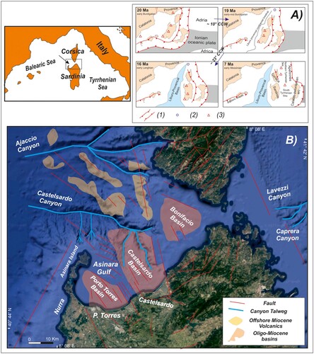
Between the islands, three deep structural depressions characterize the present-day setting of the continental shelf and slope: the Porto Torres Basin, the Castelsardo Basin and the Bonifacio Basin; they were characterized by high subsidence rates and are filled by a very thick succession of sedimentary and volcanic deposits, Tertiary to Quaternary in age.
The basins started developing since the Oligocene up to the Messinian (CitationThomas & Gennesseaux, 1986) ( (B), ). The Porto Torres and Castelsardo basins are the main half-grabens, both continuing offshore in the Asinara Gulf and Castelsardo area and inshore.
Figure 2. Sections from seismic data: (A) Porto Torres Basin (B) Castelsardo Basin (C) Bonifacio Basin; legend: (1) normal (?) fault; (2) basement; (3) Oligocene–Miocene sedimentary and volcanic sequences; (4) Pliocene–Quaternary sequences (from CitationThomas & Gennesseaux, 1986, simplified).
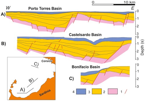
The Porto Torres Basin extends inland and is limited eastwards by a regional NW–SE trending fault, dipping westwards ((B) and (A)). The Castelsardo Basin is limited eastwards by a main N–S trending fault that extends inland and dips westward, as well ((B) and (B)). The third basin, the Bonifacio Basin, is on the north-western side of the strait and develops toward the north-east along the canyon axis; it is limited to the north by a NW–SE oriented fault, dipping southwards ((B) and (C)).
The slope of western Corsica represents the Oligocene dissected margin that was deeply eroded during the Messinian and underwent a widespread desiccation, due to the long-lasting emersion (CitationGennesseaux et al., 1989).
The continental shelf between the Islands of Sardinia and Corsica is wide and shallows in correspondence with the Bonifacio Strait, a sound less than 10 km wide between the two mainlands connecting the Sardinian Sea to the Tyrrhenian Sea and reaching a depth of about 60 m on its threshold.
On the western sector of the shelf, in the middle of the Asinara Gulf, relict morphologies and lithotomies – paleo-cliffs, paleo-barriers and dune fields – are recognized at different depth ranges. They formed during the Quaternary sea-level oscillations and are related to the shoreline migration. The recent sedimentary evolution of this area records low sedimentation rates and starved conditions. Here, several bedform fields testify to the occurrence of strong bottom currents and severe hydrodynamic conditions (CitationDe Falco et al., 2011; CitationDeiana et al., 2022; CitationOrrù et al., 2008). On the Tyrrhenian sector of the margin, the shelf widens to more than 20 km and dips gently eastwards toward the Tyrrhenian slope, behind the shelf break which is located at about 150 m depth.
3. Methods and software
As the maps were produced using the same interpretative and cartographic standards, the procedure is described in detail in Ridente and Chiocci (this volume). The legend of the Physiographic Domain map is included in the map while the legend of the Morphological Units and Morpho-bathymetric Elements map is shown as a separate table.
The geophysical data were acquired during several cruises from 2009 to 2012 on board the Research Vessels Urania, Maria Grazia and Universitatis, which were in the force of Consiglio Nazionale delle Ricerche (CNR) Italy and Consorzio Nazionale Inter universitario per le Scienze del Mare (CoNISma).
The swath-bathymetric data were acquired with a Reson Seabat 7111, a Kongsberg-Simrad EM 710 and a Kongsberg-Simrad EM 3002 echosounders. The accuracy of the bathymetric acquisition ranges from 2 to 5 m in the depth range shallower than 70 m, while at greater depths, it ranges from 5 to 10 m. The maps were edited by using the Global Mapper – Blue Marble Geographics software; Geo Suite – All Works and SEISPRHO (CitationGasperini & Stanghellini, 2007) were used for bathymetric and seismic data visualization and interpretation.
4. Maps of morphological units and morpho-bathymetric elements
4.1 Asinara (MaGIC sheet 69)
The Sheet 69 ‘Asinara’ is in the north-western sector of Sardinia Island, offshore of the Nurra tectonic block and of the southern sector of the Asinara Island.
The morphology of the coastal and deep areas is mainly controlled by tectonics; the continental slope is on the outshoot of the Nurra tectonic block, and it is bounded to the northwest by the Nurra normal fault that lowered the basement over a relatively short distance (CitationLecca, 2000) ((B)). In the southern sector of Sheet 69 ‘Asinara’, the continental shelf is characterized by a width of about 10 km; in the northern sector, it narrows, becoming 5–6-km-wide. Several rocky substrate crops out along the inner continental shelf, down to 150 m depth. The lithology of the substrate can be inferred on the base of inland basement outcrops, which, in particular those occurring in Asinara Island, consist of a terrigenous Paleozoic succession, which includes the Hercynian metamorphic complex and granitoid rocks.
As a general observation, the location of the depocenters along the margin is strictly related to the morphology of the underlying basement. Indeed, the Neogene and Quaternary sedimentary cover on the inner continental shelf is limited to small basins in the rocky substrate that, otherwise, widely crops out at the seabed. The continental shelf in the northern sector of the map is narrow and exhibits a flat topography, with a very thin sedimentary drape that points out to sediment-starved condition, given the lack of riverine inputs from the mainland. In these areas, several beach-rock alignments testify to the shifting coastal environments linked to the transgressive and regressive marine stages during Quaternary, which are so well documented that in Sardinia (CitationAndreucci et al., 2010; CitationDe Luca et al., 2022; CitationPascucci et al., 2014). The outer continental shelf shows a prograding sedimentary wedge formed by several stacking sequences also related to the Quaternary glacio-eustatic oscillations. All along the shelf, several coralligenous assemblages cover the bedrock at depth ranging between 50 and 120 m (CitationDe Falco et al., 2022; CitationDe Falco et al., 2022a; CitationDe Falco et al., 2022b; CitationDe Luca et al., 2022).
All along the Nurra area, the shelf break is located at about 200 m depth and is morphologically controlled by the Nurra main fault. A fairly well-developed sedimentary wedge has prograded at the outer shelf and the upper slope. The continental slope morphology becomes progressively more irregular southwards, mainly due to the occurrence of several rocky substrate outcrops, located between the shelf break and the canyon heads and in the canyon interfluves. Sets of straight gullies, characterized by a low hierarchical ranking, flow locally into the canyon heads, especially where the distance between them and the shelf edge is short and the slope gradient is high. Conversely, a large number of scars have developed on the low gradient slopes, especially in the southern sectors of the map.
Geohazard-related features
In view of the morpho-bathymetrical analysis carried out and the previous knowledge of the area, and also considering the extensive distance between the coastline and the morphologies linked to gravitational instability, it is considered that no particular geohazard elements should be reported.
4.2 Porto Torres (MaGIC sheet 70)
The area included in the Sheet 70 ‘Porto Torres’ shows a wide outcrop of bedrock, cut by a paleo hydrographic pattern formed during the Quaternary sea-level fluctuations (CitationAndreucci et al., 2010; CitationDe Luca et al., 2022; CitationPascucci et al., 2014; CitationRomeo et al., 2019), similarly to the adjacent continental shelf areas along the Asinara Island. Actually, the north-western and north-eastern shelf are characterized by several outcrops and flat areas with starved condition, while the eastern shelf shows a more consistent sediment coverage on the rocky basement and also some sedimentary coastal wedge in the inner shelf (CitationBudillon et al., 2022; CitationCasalbore et al., 2017).
The shelf break located in the Asinara Gulf at the eastern side of the Island shows a depositional wedge, is continuous along the whole sheet area and is located between 125–150 m of depth at a lower depth than that of the north-western side of the island; the continental shelf in the Gulf is wide and characterized by low sedimentary rates, almost flat morphology, sediment-starved conditions during the Quaternary and wide bedrock outcrops of different origin and lithology. Inside the Gulf the morphological relicts are the dune fields, located at depths ranging from 50 to 40 m; the paleo-cliffs located in depth ranging from 60 and 52 m (CitationOrrù, 2004); two main paleo-barriers alignments located at depths ranging from 75 and 80 m and 65–70, respectively; those features are related to the shoreline migration during Quaternary eustatic fluctuations changes, forming marine/continental erosional–depositional terraces and wedges, as well as the surrounding shelves of the Asinara island. The rocky outcrops on the eastern side of Asinara island and in the Gulf are characterized by coralligenous assemblage cover at depths ranging between 50 and 120 m (CitationDe Falco et al., 2022; CitationDe Falco et al., 2022a; CitationDe Falco et al., 2022b; CitationDe Luca et al., 2022).
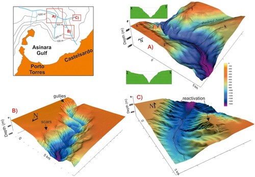
The Castelsardo Canyon represents the main morphological feature of the continental slope of the northern Sardinia margin; the canyon runs mainly westwards and is joined by several tributary channels and two side branches that flow into the main canyon axis from the left and right side The tributary channels flowing from the Asinara Island offshore into the main channel from the right side show a very steep course and lobe-shaped pattern of their heads, which cut deeply the continental slope and the sedimentary wedge in the outer shelf. In the deeper areas, the slope eases, and several scars are evident in the central part of the canyon head. In the offshore of Porto Torres, an abandoned tributary channel has been recognized, and its passage to the main canyon talweg shows a cut and a steep scarp ((A)); this abandoned feature could be related to a canyon head avulsion occurred in the Late Miocene/post-Miocene Castelsardo canyon evolution described by CitationThomas & Gennesseaux (1986).
Figure 3. 3D blocks of the Digital Elevation Model (DEM), showing the main morphological features of Castelsardo Canyon; (A) main canyon talweg and a left-lateral tributary channel detached from the main canyon axis by a 300 m-high scarp; (B) meandering course of the canyon axis; and (C) examples of morphological reactivation within a tributary channel flowing into the canyon from the eastern side.
- Geohazard-related features
The Castelsardo canyon head, northeastward of Asinara Island, cuts the shelf and its edge, reaching a distance of 5 km from the shoreline. It is mainly characterized by a steep pattern of gullies and several scars; seemingly fresh scarps, denudated of surficial sediments, suggest possible recent morphological activity within the canyon system; even here, the geohazard could be related to the effects of the progressive canyon retreating close to the coast.
4.3 Castelsardo (MaGIC sheet 71)
The Sheet 71 ‘Castelsardo’ includes the western sector of the Bonifacio Strait, which is characterized by a relatively wide continental shelf; the Castelsardo Canyon main axis divides the continental shelf into two areas ((B)). Westward from the canyon, the continental shelf is about 20-km-wide, and it is limited by a morphologic break at about 125–150 m water depth. The continental shelf is cut by Castelsardo canyon head; the eastern continental shelf pass without any particularly evident morphological break to the slope, showing slight variations in slope, and reaching the wall of the main canyon axis and an eastern branch of canyon. On the western side of the sheet, the continental shelf is about 5-km-wide, whereas it is more than 20-km-wide in the eastern side.
The rocky substrate extensively outcrops at the eastern and western sides of the canyon, on the inner and outer shelf. The geology of the bedrock may include, by analogy with inland formations, Oligocene to Miocene volcanic rocks, Miocene sedimentary formations and the Pliocene–Quaternary sedimentary cover. Along the shelf, some sediment patches are settled on the rocky substrate; in which several sorted bedforms of about 1-m-high extend for hundreds of meters and can be found in these sediment basins within the substrate, at 60–90 m water depth (CitationDe Falco et al., 2011).
Eastward of the canyon, the rocky substrate outcrops along the inner shelf down to 120–130 m depth. Also in this area, a wide coralligenous assemblage occurs on the bedrock outcrops in a depth range from 50 down to over 120 m (De Falco et al., Citation2022; Piazzi et al., Citation2022a, Citation2022b).
The Castelsardo Canyon has an indentation on the shelf of about 13 km, with a single ribbon head, reaching about 3 km from the coastline. On both sides of the canyon, less steep terraces separate the shallower portion of the canyon flanks, from the deepest part, which is characterized by fresh morphologies, engraved by several secondary channels and scars.
In the central sector of the canyon axis, a meandering pattern of the talweg develops, cutting deeply into the continental slope; on the upper part of the canyon flanks several gullies and scars and relative deposits have been recognized, where the canyon walls become steeper and gullies are dominant ((B)).
The eastern tributary channel, coming from the right side of the canyon, is characterized by a dense net of gullies and scars; seemingly fresh gullies and talweg deepening may testify to a recent reactivation of some canyon sections ((C)).
Geohazard-related features
The Castelsardo main head is located about 3 km from the coastline and is ribbon-shaped; it starts from a minimum depth of 50 m and deepens to a depth of approximately 300 m in less than 2.5 km. The eastern flank of the canyon head is punctuated by many landslide niches. On the base of the available data is not possible to constrain the age of the instability processes; however, a conservative esteem should consider a low degree of geohazard related to the morphological evolution and retrogressive trend of the canyon head close to an urbanized coastal area.
4.4 La Maddalena (MaGIC sheet 72)
The Sheet 72 ‘La Maddalena’ is located along the eastern margin of the Corsica-Sardinia block, in the western Tyrrhenian Sea.
The morphology of the continental shelf is flat and smooth, with low gradient slopes, in the range of 0.3–0.5%. In the inner shelf of Bonifacio Strait, m, sedimentary structures, like comet marks and 2D and 3D dune fields are related to tractive bottom currents, which in the depth ranges between 60 and 70 may exceed speeds of 1.5 m s−1. Some relict depositional systems, such as beach rocks and paleo-lagoons, are observable in the depth ranges between 95 and 85 m (CitationDeiana et al., 2022).
A prograding Plio-Quaternary wedge, 50 – to 150-m-thick, is located on the shelf edge, at 120–130 m water depth. A submarine depositional terrace (sensu CitationCasalbore et al., 2017) related to the last low stand event (Last Glacial Maximum) occurs on the shelf edge.
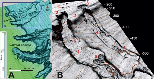
In the northern sector, the Lavezzi canyon head consists of two parallel sub-channels, which carve the outer shelf up to 110 m water depth. The channels merge downslope into a single main canyon at approximately 560 m of depth. In the head scarps, some scars affect the Pliocene–Quaternary sediment cover. The upper slope of the southern sector is dominated by the three head scarps of the Caprera Canyon ((A)), which show evidence of retrogressive erosion, by some means augmented along the tectonic lineaments. Channels are deeply incised, and numerous intra-channel landslides are detected on the flanks of the canyons ((B)).
Figure 4. (A) Shaded relief from the DEM of the NE Sardinian continental margin. (B) 3D block of the Lavezzi canyon heads: (1) beach-rocks at 100 m depth; (2) edge of the prograding continental shelf; (3) retrogressive canyon head; (4) intracanal deposit from upslope failures; (5) erosional bedforms from channelized flows; and (6) retrogressive failure undermining the toe of former landslide deposits, perching within the channel axis.
Geohazard-related features
In view of the morpho-bathymetrical analysis carried out and the previous knowledge of the area, and also considering the extensive distance between the coastline and the morphologies linked to gravitational instability, it is considered that no particular geohazard elements should be reported.
5. Conclusions
- The northern Sardinia margin is formed by tree main half-graben structures, located in between the Sardinia and Corsica islands; a great part of tectonic activity took place during the Miocene.
- The main morphological feature of the western margin is the Castelsardo canyon system; on the east side, the main features are the Lavezzi and Caprera canyons.
- Active and relict fields of morphological features as bedform, recognized in the Bonifacio strait, testify to the strong bottom currents and severe hydrographic conditions that may occur on the shelf.
- Several coastal morphological features (coastal barriers, beach rocks, etc), located on the shelf, along the whole margin, document the late Quaternary sea-level oscillation. The extensive thematic mapping based on the recently acquired swath-bathymetric data allows us to verify the continuity of these features along the margin.
- The geohazard-related potential in the study area, is linked to the Castelsardo canyon head located offshore of Castelsardo village and to the tributary channel head located offshore of the Asinara Island, given the short distance between those features and the shoreline, even though it is not possible to determine whether the instability processes are actually active.
Map design
As the maps were produced using the same interpretative and cartographic standards, the procedure is described in detail in Ridente and Chiocci (this volume). The legend of the Physiographic Domain map is present on the map while the legend of the Morphological Units and Morpho-bathymetric Elements map is present as a separate table. Global Mapper and Geo Suite were used for bathymetric and seismic data visualization and interpretation. Consider that the maps are realized after a discussion between guest editors along with the editorial board of Journal of Map.
17_G_F_of the Northern Sardinia margin_Conforti.pdf
Download PDF (29.5 MB)Acknowledgements
The Magic Project has been funded by the Italian Civil Protection Department; we thank officers and crews of R/V Urania and Maria Grazia (CNR), R/V Universitatis (CoNISma) and R/V Explora (OGS), which acquired the data. We also would like to thank the ‘Istituto Idrografico della Marina Militare Italiana’ (Hydrographic Italian Navy Service) that provided data of deepest part of the Castelsardo Canyon.
Disclosure statement
No potential conflict of interest was reported by the author(s).
Data Availability Statement
Data are available upon reasonable request by contacting the first authors at the mail address: [email protected], [email protected].
Additional information
Funding
References
- Andreucci, S., Clemmensen, L. B., Murray, A. S., & Pascucci, V. (2010). Middle to late Pleistocene coastal deposits of Alghero, Northwest Sardinia (Italy): Chronology and evolution. Quaternary International, 222(1–2), 3–16. https://doi.org/10.1016/j.quaint.2009.07.025
- Beccaluva, L., Gabbianelli, G., Lucchini, F., Rossi, P. L., & Savelli, C. (1985). Petrology and K/Ar ages of volcanics dredged from the Eolian seamounts: Implications for geodynamic evolution of the southern Tyrrhenian basin. Earth and Planetary Science Letters, 74(2-3), 187–208. https://doi.org/10.1016/0012-821X(85)90021-4
- Budillon, F., Amodio, S., Alberico, I., Contestabile, P., Vacchi, M., Innangi, S., & Molisso, F. (2022). Present-day infralittoral prograding wedges (IPWs) in Central-Eastern Tyrrhenian Sea: Critical issues and challenges to their use as geomorphological indicators of sea level. Marine Geology, 450, 106821. https://doi.org/10.1016/j.margeo.2022.106821
- Carmignani, L., Oggiano, G., Barca, S., Conti, P., Funedda, A., Pasci, S., & Salvadori, I. (2001). Geologia della Sardegna (Note illustrative della Carta Geologica della Sardegna a scala 1:200.000). Istituto Poligrafico e Zecca Dello Stato, Roma, 284.
- Carminati, E., Lustrino, M., Cuffaro, M., & Doglioni, C. (2010). Tectonics, magmatism and geodynamics of Italy: What we know and what we imagine. Journal of the Virtual Explorer, 36, https://doi.org/10.3809/jvirtex.2010.00226
- Casalbore, D., Falese, F., Martorelli, E., Romagnoli, C., & Chiocci, F. L. (2017). Submarine depositional terraces in the Tyrrhenian Sea as a proxy for paleo-sea level reconstruction: Problems and perspective. Quaternary International, 439, 169–180. https://doi.org/10.1016/j.quaint.2016.02.027
- Casula, G., Cherchi, A., Montadert, L., Murru, M., & Sarria, E. (2001). The Cenozoic graben system of Sardinia (Italy): Geodynamic evolution from new seismic and field data. Marine and Petroleum Geology, 18(7), 863–888. https://doi.org/10.1016/S0264-8172(01)00023-X
- Cherchi, A., & Montadert, L. (1982). Oligo-Miocene rift of Sardinia and the early history of the Western Mediterranean basin. Nature, 298(5876), 736–739. https://doi.org/10.1038/298736a0
- De Falco, G., Conforti, A., Brambilla, W., Budillon, F., Ceccherelli, G., De Luca, M., Di Martino, G., Guala, I., Innangi, S., Pascucci, V., Piazzi, L., Pireddu, L., Santonastaso, A., Tonielli, R., & Simeone, S. (2022). Coralligenous banks along the western and northern continental shelf of Sardinia Island (Mediterranean Sea). Journal of Maps, 18(2), 200–209. https://doi.org/10.1080/17445647.2021.2020179
- De Falco, G., De Muro, S., Batzella, T., & Cucco, A. (2011). Carbonate sedimentation and hydrodynamic pattern on a modern temperate shelf: The strait of Bonifacio (Western Mediterranean). Estuarine, Coastal and Shelf Science, 93(1), 14–26. https://doi.org/10.1016/j.ecss.2011.03.013
- Deiana, G., Demurtas, V., & Orrù, P. E. (2023). Bedforms of Bonifacio strait (Western Mediterranean): Hydrodynamics, coastal outline, supply and sediment distribution. Geological Society, London, Special Publications, 523(1), 195–212. https://doi.org/10.1144/SP523-2022-10
- De Luca, M., Pascucci, V., Puccini, A., Pireddu, L., Santonastaso, A., Stelletti, M., Gazale, V., & Zanello, A. (2022). Sea floor of the marine protected area of the Asinara island (Sardinia, Italy). Journal of Maps, 18(2), 288–299. https://doi.org/10.1080/17445647.2022.2052765
- Gasperini, L., & Stanghellini, G. (2009). SEISPRHO: An interactive computer program for processing and interpretation of high-resolution seismic reflection profiles. Computers & Geosciences, 35(7), 1497–1507. https://doi.org/10.1016/j.cageo.2008.04.014
- Gattacceca, J. (2001). Cinématique du bassin liguro–provencal entre 30 et 12 Ma. Implications géodynamiques [PhD thesis]. Ecole des mines de Paris, 299 pp.
- Gennesseaux, M., Rehault, J.-P., & Thomas, B. (1989). La marge continentale de la Corse. Bulletin de la Société Géologique de France, 8, 33–351.
- Lecca, L. (2000). La piattaforma continentale miocenico-quaternaria del margine occidentale sardo: Blocco diagramma sezionato. Rendiconti Del Seminario Della Facoltà Di Scienze Dell'università Di Cagliari, 70, 49–70.
- Lecca, L., Lonis, R., Luxoro, S., Melis, E., Secchi, F., & Brotzu, P. (1997). Oligo-Miocene volcanic sequences and rifting stages in Sardinia: A review. Periodico di Mineralogia, 66, 7–61.
- Lonergan, L., & White, N. (1997). Origin of the Betic-Rif mountain belt. Tectonics, 16(3), 504–522. https://doi.org/10.1029/96TC03937
- Oggiano, G., Funedda, A., Carmignani, L., & Pasci, S. (2009). The Sardinia-Corsica microplate and its role in the northern Apennine geodynamics: New insights from the tertiary intraplate strike-slip tectonics of Sardinia. Italian Journal of Geosciences, 128(2), 527–539.
- Orrù, P. E. (2004). Atlante dei tipi geografici, Morfologia sommersa a cura di Rodolfi G. e Pranzini E.,Istituto grografico militare, Firenze. Tavola, 34, 1–3.
- Orrù, P. E., Puliga, G., & Deiana, G. (2008). Rilevamento degli elementi di pericolosità geomorfologica nelle Bocche di Bonifacio e nel margine sud-occidentale sardo. Rendiconti Online Società Geologica Italiana, 2, 598–599.
- Pascucci, V., Sechi, D., & Andreucci, S. (2014). Middle Pleistocene to Holocene coastal evolution of NW Sardinia (Mediterranean Sea, Italy). Quaternary International, 328–329, 3–20. doi:doi.org/10.1016/j.quaint.2014.02.018
- Piazzi, L., De Falco, G., De Luca, M., Guala, I., Borras Palomar, A., Conforti, A., Pascucci, V., Simeone, S., & Ceccherelli, G. (2022a). Coralligenous assemblages of continental shelf: Multiple spatial scale variability in the western Sardinia. Continental Shelf Research, 245, 104790. https://doi.org/10.1016/j.csr.2022.104790
- Piazzi, L., Ferriglio, F., Guala, I., Cinti, M. F., Conforti, A., De Falco, G., De Luca, G., La Manna, D., Pascucci, G., Pansini, V., Pinna, A., Pireddu, F., Puccini, L., Russo, A., Sandulli, G. F., Santonastaso, R., Simeone, A., Stelletti M, S., Stipcich, P., … Ceccherelli, G. (2022b). Inconsistency in community structure and ecological quality between platform and cliff coralligenous assemblages. Ecological Indicators, 136, 108657. https://doi.org/10.1016/j.ecolind.2022.108657
- Réhault, J. P., Boillot, G., & Mauffret, A. (1984). The Western Mediterranean basin geological evolution. Marine Geology, 55(3-4), 447–477. https://doi.org/10.1016/0025-3227(84)90081-1
- Rollet, N., Déverchere, J., Beslier, M. O., Guennoc, P., Réhault, J. P., Sosson, M., & Truffert, C. (2002). Back arc extension, tectonic inheritance, and volcanism in the Ligurian Sea, Western Mediterranean. Tectonics, 21(3).
- Romeo, R., Baradello, L., Blanos, R., Congiatu, P. P., Cotterle, D., Ciriaco, S., Donda, F., Deponte, M., Gazale, V., Gordini, E., Lodolo, E., Paganini, P., Pavan, A., Pietrapertosa, C., Sterzai, P., Vargiu, G., Zanello, A., Ramella, R., & Nieto Yabar, D. G. (2019). Shallow geophysics of the Asinara island marine reserve area (NW Sardinia, Italy). Journal of Maps, 15(2), 759–772. https://doi.org/10.1080/17445647.2019.1669498
- Serri, G., Innocenti, F., & Manetti, P. (1993). Geochemical and petrological evidence of the subduction of delaminated Adriatic continental lithosphere in the genesis of the Neogene–quaternary magmatism of central Italy. Tectonophysics, 223(1-2), 117–147. https://doi.org/10.1016/0040-1951(93)90161-C
- Speranza, F., Villa, I. M., Sagnotti, L., Florindo, F., Cosentino, D., Cipollari, P., & Mattei, M. (2002). Age of the Corsica–Sardinia rotation and Liguro–Provençal basin spreading: New paleomagnetic and Ar/Ar evidence. Tectonophysics, 347(4), 231–251. https://doi.org/10.1016/S0040-1951(02)00031-8
- Thomas, B., & Gennesseaux, M. (1986). A two-stage rifting in the basins of the Corsica-Sardinian straits. Marine Geology, 72(3-4), 225–239. https://doi.org/10.1016/0025-3227(86)90121-0
- Thomas, B., Lecca, L., & Gennesseaux, M. (1988). La Structure de la marge occidentale de la Sardaigne et la fragmentation de l’ile au Cénozoïque. Marine Geology, 83(1–4), 31–41. https://doi.org/10.1016/0025-3227(88)90050-3