
ABSTRACT
The Cordillera Darwin Icefield (CDI) has experienced widespread retreat since the Little Ice Age (LIA, ∼1870 AD). Prior to this, information on outlet glacier dynamics is limited as there are few terrestrial observations and little mapped deglacial evidence, limiting our understanding of CDI dynamics on Holocene centennial to millennial timescales. Here we present a glacial geomorphological map of terrestrial landforms and features for the CDI and surrounding areas of the Tierra del Fuego archipelago. We digitized more than 8,000 glacial landforms and features covering an area of ∼13,300 km2 from a combination of digital elevation models (DEMs) and high-resolution satellite and aerial imagery (<3 m), supported by multitemporal field mapping. This work provides a detailed geomorphological assessment for the area, summarized in a single map, that identifies three main glacial landsystem types of the Patagonian–Fuegian landscape: (i) upland glacier, (ii) lowland land-terminating, and (iii) glaciomarine fjord. The resulting map forms the basis for future chronological campaigns.
1. Introduction
Since the mid-1980s, Cordillera Darwin glaciers experienced notable mass loss (Barcaza et al., Citation2017; Braun et al., Citation2019; Davies & Glasser, Citation2012; Dussaillant et al., Citation2019; Hugonnet et al., Citation2021; Meier et al., Citation2018). This mass loss is explained in part by regional warming that began in the 1940s and accelerated since the 1960s (Carrasco et al., Citation2002; Rasmussen et al., Citation2007; Rosenblüth et al., Citation1997), followed by increased ice discharge from accelerated tidewater outlet glaciers (Koppes et al., Citation2009; Melkonian et al., Citation2013). Twentieth century warming caused many land-terminating glaciers to thin and fragment (Meier et al., Citation2018; Melkonian et al., Citation2013), which has promoted the expansion and new formation of proglacial lakes (Izagirre et al., Citation2018; Loriaux & Casassa, Citation2013; Wilson et al., Citation2018). Ice velocity of some tidewater outlet glaciers increased and their fronts retreated significantly (e.g. Marinelli, Darwin, and Grande/CDI-08 glaciers), while some glaciers remained stable or advanced on the southern slope of the icefield (e.g. Glaciar Garibaldi and some other glaciers in the inner part of Fiordo Pia) (Bown et al., Citation2014; Braun et al., Citation2019; Masiokas et al., Citation2020; Melkonian et al., Citation2013).
Recent and open access to spaceborne imagery facilitates reconstruction of glacier fluctuations in southern Patagonia and Tierra del Fuego since the early 1980s. It is more difficult to estimate spatial and temporal changes prior to this period because landforms are sparsely mapped, proxy data are scarce and direct observations are sporadic (Bertrand et al., Citation2017; Davies et al., Citation2020; Hall et al., Citation2013, Citation2019; Kuylenstierna et al., Citation1996; Meier et al., Citation2019; Menounos et al., Citation2020; Reynhout et al., Citation2021; Strelin et al., Citation2008). The recent glacial history of the region was has been determined since the Little Ice Age (LIA, ∼1870 AD) with the help of historical maps and written reports (Bown et al., Citation2014; Lopez et al., Citation2010), as well as aerial photographs from the 1940s onwards (Holmlund & Fuenzalida, Citation1995; Porter & Santana, Citation2003) and the determination of glacier extent using remote sensing imagery (Davies & Glasser, Citation2012; Meier et al., Citation2018). Reconstructions on these timescales are important for understanding present-day dynamic changes (Rodbell et al., Citation2009; Zemp et al., Citation2011), but these limited observational data complicate the analysis of glacier dynamics before the LIA and during the Holocene centennial and millenial scales (Davies et al., Citation2020; Hall et al., Citation2019).
Detailed mapping of glacial landforms in areas with current and past glaciers and ice masses is thus a key component for reconstructing past ice extent fluctuations, understanding current glacier dynamics, and assessing potential future responses to climate change (Davies et al., Citation2020; Newall et al., Citation2020; Soteres et al., Citation2020; Stokes et al., Citation2015). To improve the understanding of glacier fluctuations at Holocene centennial-to-millennial timescales for the southern margin of South America, we produced a new detailed glacial geomorphological map to support further work on the glacial history of the Cordillera Darwin and adjacent areas.
2. Study area and previous work
2.1. Cordillera Darwin Icefield (CDI)
The Cordillera Darwin mountain range (54°30’S, 69°30’W) is about 200 km long and extends from west to east along the southwestern peninsula of the main island of Tierra del Fuego (), following the northern edge of the Scotia Plate and bounded mainly by the Fiordo Almirantazgo to the north and the Canal Beagle to the south (; Holmlund & Fuenzalida, Citation1995; Klepeis, Citation1994; Lopez et al., Citation2010; Melkonian et al., Citation2013). The centre of the mountain axis exceeds 2,000 m above sea level (asl) and culminates in Monte Shipton (2,568 m asl). With an area of ∼1,760 km2 the Cordillera Darwin Icefield (CDI) covers highest elevations of the mountain range and is the third largest temperate icefield in the Southern Hemisphere (Bertrand et al., Citation2017; Koppes et al., Citation2009; Meier et al., Citation2018; Porter & Santana, Citation2003). The CDI is characterised by gently sloping high-plateaus, most of which are large outlet glaciers draining to sea level, and many of which calve into deep fjords or are currently transitioning to land-terminating glaciers; many of the latter calve into proglacial lakes (Holmlund & Fuenzalida, Citation1995; Izagirre et al., Citation2018; Porter & Santana, Citation2003). In the west, there are some smaller ice bodies (totalling ∼179 km2) in the Monte Sarmiento massif and the Cordón Navarro range, along with many other adjacent smaller glaciers (Meier et al., Citation2018).
Figure 1. Southern South America, including plate boundaries (Bird, Citation2003), modern icefields (in white), locations mentioned in the text, and the study area, overlaid on a GEBCO GDEM for orography and bathymetry. The isobath of −125 m is used to simulate the approximate past position of the coastlines at LGM (Lambeck et al., Citation2014; Siddall et al., Citation2003). The Patagonian Ice Sheet (PIS) ice extent at 25 ka is also shown (in light blue) and was extracted from PATICE (Davies et al., Citation2020). Present-day main ice masses are from RGI v6.0, Region 17 (RGI Consortium, Citation2017). NPI: Northern Patagonia Icefield; SPI: Southern Patagonia Icefield; GCN: Gran Campo Nevado; SI: Santa Inés; CDI: Cordillera Darwin Icefield; IH: Isla Hoste.
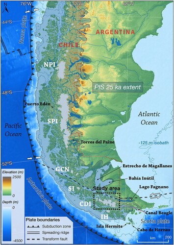
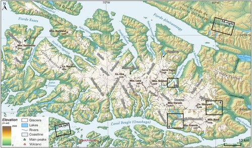
Figure 2. Location map of the study area in the Cordillera Darwin, including the main geographical features and the main outlet glaciers of the Cordillera Darwin Icefield (CDI) and surrounding areas. The boxes indicate the location and identification of additional figures presented in the following sections. Contemporary glacier outlines are taken from the ‘Chilean Public Inventory of Glaciers’ (CitationDGA, 2022).
The Cordillera Darwin is located in the present-day core of the southern westerlies and is nourished by relatively uniform precipitation throughout the year (Garreaud et al., Citation2013), although it is spatially heterogeneous due to the pronounced orographic effect of the Andes (Bown et al., Citation2014; Holmlund & Fuenzalida, Citation1995). Compared to the wetter southern and western slopes of the Cordillera Darwin, higher temperatures and lower precipitation are observed on the drier northern and eastern slopes (Holmlund & Fuenzalida, Citation1995; Koppes et al., Citation2009; Strelin & Iturraspe, Citation2007). This effect leads to a strong W-E climate gradient (Carrasco et al., Citation2002; Meier et al., Citation2018), with precipitation reaching up to 5,000 mm/yr at the top of the icefield (Fernandez et al., Citation2011), and decreasing sharply towards the east to ∼500 mm/yr (Carrasco et al., Citation2002). Regional mean temperatures fluctuate between 0 and 15°C throughout the year, with temperatures in the upper areas of the CDI remaining close to 0°C in summer (Fernandez et al., Citation2011; Meier et al., Citation2019; Sagredo & Lowell, Citation2012). Thus, the cold-maritime climate in the western and upper sections transitions to a steppe-like climate northeast and east of the mountain range (Reynhout et al., Citation2021), the latter also characterised by the presence of rock glaciers (Holmlund & Fuenzalida, Citation1995).
2.2. Previous mapping and brief glacial history
Nordenskjöld (Citation1899) produced the earliest map of the extent of Patagonian and Fuegian glaciations during the Quaternary. He recognised several moraines, that he interpreted as representing several glacial phases (Rabassa, Citation2008). Since then, a comprehensive regional map of the glacial geomorphology of southern South America has been produced by Glasser and Jansson (Citation2008) based on remote sensing imagery, which is necessarily coarse in scale due to the spatial resolution of the satellite imagery (15–30 m) and digital elevation model (DEM, 90 m) used (Glasser et al., Citation2008).
During the Last Glacial Maximum (LGM), ice extended from the Cordillera Darwin and merged with the Santa Inés (SI) and Gran Campo Nevado (GCN) icefields to the north (), forming the southern extensions of the Patagonian Ice Sheet (PIS), which extended along the central axis of the Andes from 38°S to 55°S (Caldenius, Citation1932; Clapperton et al., Citation1995; Davies et al., Citation2020; Glasser & Jansson, Citation2005). Numerous studies examined the different ice lobes of the PIS in the Estrecho de Magallanes, Bahía Inútil and on Isla Grande de Tierra del Fuego, where glacial landforms are well preserved and ice extent is well constrained between 35 and 20 ka (; Bentley et al., Citation2005; Coronato et al., Citation2009; Darvill et al., Citation2014; Kaplan et al., Citation2008; Peltier et al., Citation2021; Rabassa et al., Citation2000; Soteres et al., Citation2020; Waldmann et al., Citation2010).
On the eastern flanks of the PIS, the date of LGM maximum extension of the Lago Fagnano and Canal Beagle ice lobes is unknown (Hall et al., Citation2013), although it is assumed that ice extended to the easternmost end of the two water bodies (Caldenius, Citation1932; Coronato et al., Citation2009; Davies et al., Citation2020; Rabassa et al., Citation2000). For the western margin of the southern extensions of the PIS, it is assumed that ice extended offshore to the continental margin, but there is little evidence for this (Davies et al., Citation2020), with the exception of single radiocarbon age determinations from the Puerto Edén site further north (; Ashworth et al., Citation1991). To address this lack of data in the reconstruction of PIS dynamics in southwestern Patagonia, a glacial geomorphological map between GCN and Estrecho de Magallanes was created by Rodriguez et al. (Citation2023) using extensive high-resolution imagery. To the south, the southernmost limit of the PIS was confirmed with greater certainty after new evidence of regional glaciation was found on the west coast of Isla Hermite, suggesting an extension of the Paso Mantellero ice lobe towards the Islas Hermite and Cabo de Hornos archipelago (; Hodgson et al., Citation2023).
Several studies reconstructed the retreat of the southern extensions of the PIS into the CDI during the end of the Last Glacial (after 18 ka) using models and geochronological data. However, the timing of the retreat towards the present-day positions of the icefield remains equivocal. CitationMcCulloch et al. (2005) proposed stratigraphic evidence for ice stabilisation during retreat at the northern tip of Isla Dawson, which created two large proglacial lakes in the present-day Estrecho de Magallanes and Bahía Inútil areas between the LGM moraine limits to the north and the ice to the south. This ‘Glacial stage E’ in the Estrecho de Magallanes area is synchronous with the ‘Magellan Late Glacial advance’ at 15.3–12.2 ka, which is associated with the Antarctic Cold Reversal (ACR; Sugden et al., Citation2005). This hypothesis is consistent with similarly timed glacial advances in Torres del Paine (García et al., Citation2012) and on the sub-Antarctic island of South Georgia (Graham et al., Citation2017).
In contrast, earlier retreat is supported by a series of geochronological ages from peat bogs near the present-day CDI that demonstrate rapid ice retreat from LGM positions towards the heart of the Cordillera Darwin by 17.1–16.8 ka in the north and 14.8–14.5 ka in the south (Hall et al., Citation2013, Citation2017). These ages are supported by dated marine sediment cores from Fiordo Almirantazgo, which indicate ice-free/marine conditions around ∼15.5 ka (Boyd et al., Citation2008), as well as marine geological evidence for rapid ice retreat after deglaciation (Fernández et al., Citation2017). In the eastern (Puerto Haberton) and central (Punta Burslem) sectors of Canal Beagle, minimum ages from peat bogs indicate ice-free conditions before 17.8 and 17.0 ka, respectively (McCulloch et al., Citation2020). Alpine areas immediately north of Ushuaia and Canal Beagle became ice-free by ∼16.9 ka with later glacier advances limited to cirques during the ACR (Menounos et al., Citation2013).
The extent and chronology of Holocene glaciers in the region remains poorly known, apart from an increasing number of well constrained areas that demonstrate the reduced nature of the icefield (Davies et al., Citation2020). Regional studies have focused on specific glacier areas (), such as the Monte Sarmiento massif (Meier et al., Citation2019; Strelin et al., Citation2008), Glaciar Marinelli (Bertrand et al., Citation2017; Hall et al., Citation2019; Izagirre et al., Citation2018), Glaciar Dalla Vedova (Reynhout et al., Citation2021), Glaciar Stoppani (Menounos et al., Citation2020), and Fiordo Pía (Kuylenstierna et al., Citation1996), where the glaciers were limited and, similar to the Late Holocene (0.5–0.2 ka), terminated just beyond current extents (Davies et al., Citation2020). This last period of expanded glacier growth in the Holocene, known as the LIA, has a distinct glacial geomorphology with prominent landforms such as moraine ridges and trimlines (Davies & Glasser, Citation2012; Hall et al., Citation2019; Izagirre et al., Citation2018; Meier et al., Citation2018;, Porter & Santana, Citation2003).
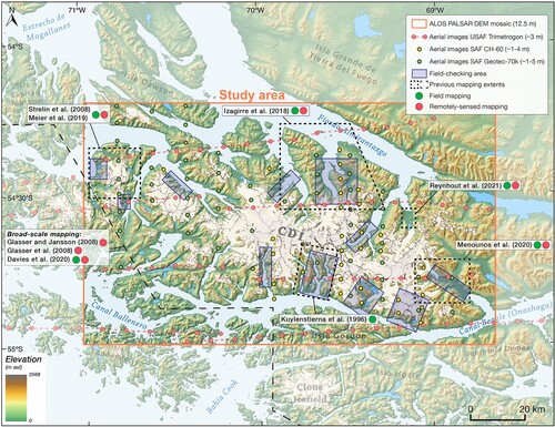
Figure 3. Regional map of the study area (orange rectangle) with the principal points of the aerial photographs used and described in the text. In addition, the published mapping and its type (field-based or remotely-sensed) and the areas that were verified in the field (blue rectangles) are indicated. Contemporary glacier outlines, taken from the ‘Chilean Public Inventory of Glaciers’ (CitationDGA, 2022).
3. Mapping methods
We identified and mapped glacial landforms using satellite and aerial imagery and DEMs. In parallel, ground surveys were carried out in several fieldwork campaigns from 2013 to 2022, which allowed us to compare the landforms recorded remotely in different areas (). Due to the remoteness, vastness and challenging nature of the area, it was not possible to survey the entire study area in situ, but the fieldwork focused on the main accessible sites around the current CDI.
The glacial geomorphological mapping of the CDI and its surroundings covers an area of ∼13,300 km2 and was carried out at scales of 1:1,500 to 1:40,000 with QGIS (v 3.28.1-Firenze) using the WGS 84 / UTM Zone 19S coordinate reference system of the Southern Hemisphere. We used the NASA Shuttle Radar Topography Mission (SRTM GL1) Global 1 arcsec degree (30 m spatial resolution) from the Open Topography repository (SRTM, Citation2013) to identify the largest glacial features, such as distinct moraine ridges (A). To complement the SRTM GL1, we also used a medium-resolution composite DEM derived from the Radiometric Terrain-Corrected (RTC) ALOS PALSAR Global Radar Imagery (12.5 m spatial resolution) obtained from the Alaska Satellite Facility (ASF) Vertex repository (https://asf.alaska.edu) for mapping (B). This last DEM provided the topographic context, and a relief-shaded model was created to overlay under the geomorphological mapping (F).
Figure 4. Steps during the mapping process for the area of Glaciar Stoppani (GS) and Glaciar Alessandri (GA). (A) In a first pass, the largest glacial features such as pronounced moraine ridges and glacial cirques were mapped from the SRTM GL1 DEM. The map shows the area in the easternmost part of the Cordillera Darwin Icefield (CDI). (B) The hillshade relief model derived from the medium-resolution ALOS PALSAR DEM reveals additional landforms and large glacier areas. Inset image shows a section of a vertical aerial photograph from the USAF Trimetrogon campaign of 1944/45, showing a glacial lake at that time. (C) Combination of hillshade (50% transparent) with a Sentinel-2 satellite image from 20 February 2022 (bands 11-8-4), which improves the mapping resolution of moraines, trimlines, lakes and the distal outwash plain. Inset image shows the coarse resolution of this image for smaller features. (D) A PlanetScope satellite image from 21 February 2022 (bands 4-3-2) allows the identification of more landforms and the distinction between glaciers and ice patches or between predominantly stable mountain lakes and dynamic glacial lakes. Inset image shows the improvement in spatial resolution with this imagery. (E) ESRI satellite imagery with the highest resolution, which significantly improves the quality of the mapping and reveals many more landforms that were previously unrecognisable, such as rock glaciers, lake shorelines, large glacial lineations, cirque moraines, etc. Inset image shows the finest mapping resolution. (F) Final map generation (respecting the legend of the Main Map) using datasets A to E with overlay of mapping on the hillshade DEM.
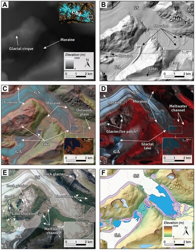
In total, the satellite and aerial images include five cloud-free ESA Sentinel-2 (MSI) satellite images acquired between 2017 and 2022 (10 m spatial resolution in four visible and near-infrared bands; C), 48 high-resolution PlanetScope 4-band satellite images with ∼3 m spatial resolution acquired between 2022 and 2024 (Imagery ©2024 Planet Labs PBC; Planet Team, Citation2024; D), and 83 nadir aerial photographs at scales of 1:60,000 and 1:70,000 (∼3–5 m spatial resolution), acquired by the Servicio Aerofotogramétrico de Chile (SAF) in 1984 (CH-60) and 1996 and 2001 (Geotec-70k), respectively. To obtain coverage of glacial landscapes closer at the end of the LIA, we also used 216 cloud-free vertical and oblique aerial photographs from 1944/45 (with a spatial resolution of ∼3–5 m) from the U.S. Air Force (USAF) Trimetrogon campaign (Lliboutry, Citation1998; B). For key areas, ESRI satellite, Google satellite and DigitalGlobe/GeoEye-1 imagery at ∼1 m resolution, available via QGIS ‘QuickMapServices’ (E), and Google EarthTM software (v 7.3) for 3D visualization, were used.
We display present-day glaciers using the latest version of the ‘Chilean Public Inventory of Glaciers’ (https://dga.mop.gob.cl/Paginas/InventarioGlaciares.aspx; CitationDGA, 2022). To improve accuracy, we updated glacier outlines to the end of the austral summer of 2022 by manual mapping using ESA Sentinel-2 and PlanetScope satellite imagery, as the publicly available outlines have not been updated in this region. We also distinguished between glaciers and ice patches and/or glacier ice remnants when the ice area was less than 0.02 km2.
Of all the mapped lakes, those that are in direct contact with the CDI and were formed after the end of the LIA, but have lost contact with the ice margin, were considered as glacial lakes. This is because ice-dammed and moraine-dammed lakes have undergone the greatest changes after the LIA (Loriaux & Casassa, Citation2013), and are susceptible to further changes due to their interaction with glacier dynamics and newly formed moraines (Harrison et al., Citation2018; Wilson et al., Citation2018). For this purpose, the LIA glacier extents mapped by Davies and Glasser (Citation2012) and Meier et al. (Citation2018) were compared with USAF Trimetrogon aerial images from 1944/1945 and posterior aerial and satellite imagery.
4. Glacial geomorphology
In this section, we provide a brief description of the glacial geomorphology of the CDI and its surrounding area. In total, we manually digitised and mapped 15 main glacial landforms and features as line and/or polygon symbols on the geomorphological map (Main Map), compiling a total of more than 8,000 landforms and features which have been grouped in the following 12 subsections. We also mapped main mountain peaks, rivers and streams, other lakes and alluvial fans to provide a broader topographic context, resulting in a total of more than 11,500 features mapped.
4.1. Contemporary glaciers
There are currently 1,130 glaciers in the Cordillera Darwin mountain range, covering a total area of ∼2,356 km2 in 2022. In case of the CDI, this continuous ice mass covers an area of ∼1,656 km2 and it is drained by 18 major outlet glaciers. The compound basin of the Marinelli glacier is still the largest glacier in the icefield (Izagirre et al., Citation2018), with an area of 112.3 km2 and a length of 18.2 km, followed by the Roncagli/Alemania (102.1 km2) and Stoppani (95.1 km2) glaciers (). It is worth noting that the terminus of the Grande/CDI-08 glacier has recently been cut off on two different fronts, resulting in the former second largest glacier being split into two medium-sized glaciers (Norte and Sur) of 63.5 and 49.5 km2, respectively.
4.2. Rock glaciers
Rock glaciers are recognisable as lobe- or tongue-shaped landforms consisting of a complete rock debris cover with a series of ridge-and-furrow surface topography (RGIK, Citation2022). In this mapping, we recorded many rock glaciers for the first time, some of which were mentioned by Holmlund and Fuenzalida (Citation1995) for the north side of Fiordo Almirantazgo as an indicator of drier conditions. Most of them are located in the lower mountains and massifs in the north and east of the Cordillera Darwin (Main Map). In Tierra del Fuego, there are only a few observations of rock glaciers and mountain permafrost (Redondo-Vega, Citation2004; Trombotto, Citation2008; Valcárcel-Díaz et al., Citation2006).
4.3. Glacial cirques
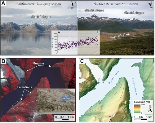
Large amphitheatre-shaped, gently-sloping hollows at high elevations that are open downstream and bounded upstream by prominent headwall or mountain flanks, are mapped as glacial cirques (Evans & Cox, Citation1974; Glasser et al., Citation2008; Oliva et al., Citation2020). They are characteristic of mountain glaciation, reflect former glacial origins and are key to understanding many interactions between glaciers, climate and topography (Anders et al., Citation2010; Barr & Spagnolo, Citation2015). Although many cirques in southernmost South America still contain glaciers (Araos et al., Citation2018), here we map numerous glacier-free cirques connected by rocky or morainic thresholds to valleys where small mountain lakes are widespread and periglacial processes extend to the northeast. Their mean altitude is 712 m a.s.l., although there is a strong gradient between the southwestern, low-lying section of the archipelago, where the mean altitude drops to 545 m a.s.l., and the northeastern mountain section, where the mean altitude rises to 851 m a.s.l (A).
Figure 5. Examples of glacial cirques and lineations in the field and on remote sensing data. (A) Glacial cirques in the southwestern, low-lying part of the Fueguian archipelago on the north side of Isla Londonderry (left), and glacial cirques in the highest elevations of the northeastern mountain section above the outwash plain of La Paciencia valley. The inset diagram shows the altitudinal distribution of glacial cirques from west to east of the study area. (B) Satellite image (PlanetScope ©2022) from the inner part of Fiordo Parry, where polished bedrock can be identified as glacial lineations, confirmed by a field image (inset) showing chatter marks indicating past ice flow. (C) Mapped glaciers, glacial lineations and moraines in the same area as B. The background DEM is the ALOS PALSAR and the legend is the same as in the Main Map.
4.4. Glacial lineations
Glacial lineations usually occur within glacial valleys where warm-based ice flow has abraded the bedrock (polished bedrock) or deposited sediments, and indicate the former direction of ice flow by a linear, mostly elongate and parallel morphology (Cooper et al., Citation2021; Glasser et al., Citation2008; Izagirre et al., Citation2018; Stroeven et al., Citation2013). In the case of polished bedrock, whalebacks, roches moutonnées and glacial chatter marks are also interpreted as an indication of the former glacier flow direction (B,C). These lineations are common in the Devonian–Carboniferous metamorphic rocks (gneiss, quartzite and marble) and Lower Cretaceous plutonic rocks (granite and granodiorite) around the icefield, while they are also occasionally found in Jurassic–Cretaceous mafic volcanic rocks (gabbro and diabase) and Upper Jurassic–Lower Cretaceous marine sedimentary sequences (sandstone, mudstone and conglomerate) (Sandoval & De Pascale, Citation2020; SERNAGEOMIN, Citation2003). Flute-like sedimentary lineations occur in recently deglacierised areas of medium to small mountain glaciers towards the northeast.
4.5. Trimlines
Glacial trimlines are interpreted as glaciogenic linear landforms that mark a break or transition in vegetation, weathered material, erosion patterns, deposited material, or slope features on the slopes of a glacierised (historical) or glaciated (Quaternary) valley (Rootes & Clark, Citation2020). While the latter have rarely been studied in southernmost South America (Möller et al., Citation2010), the former are characteristic features around present-day icefields and mark the former surfaces and ice thicknesses of outlet glaciers along their valley sides, reflecting the thinning and retreat of glaciers from their maximum LIA (historical) position (Davies et al., Citation2020; Glasser et al., Citation2008; Harrison et al., Citation2007). Many glacial trimlines mapped around the CDI transition downglacier into lateral and terminal moraines representing the maximum extent of LIA (Davies & Glasser, Citation2012; Meier et al., Citation2018), with clear examples in the valley sides of the largest glaciers, such as Marinelli (Izagirre et al., Citation2018), Stoppani (F; Menounos et al., Citation2020) and Roncagli/Alemania ().
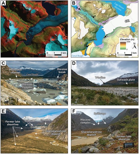
Figure 6. An example of a lowland land-terminating glacial landsystem in the CDI. (A) Satellite image (Sentinel-2 of February 20, 2022) from the area of Glaciar Roncagli/Alemania (GR), where a drained, ice-dammed glacial lake can be seen in the east of the image (in yellow dashed polygon). (B) Mapped glacial geomorphology of the same area as A; in this case, the glacial lake mentioned is completely mapped, as drainage and filling events have taken place in recent years, similar to the opposite Lago Mateo Martinic. The exact location of the photos taken in the field (2018) is also indicated. The legend is the same as in the Main Map. (C) Southwest view of the proglacial lake of GR and the moraine complex that dams it. A former meltwater channel and a more recent moraine break can be seen, along with Canal Beagle and Isla Gordon in the background. (D) Northeast view from the glacial lake outburst flood (GLOF) deposit, with the forested flat outwash plain on the right and the clear trimline of the GR in the background. (E) Southeast view of the Taranaki valley, a former ice-dammed lake, where the former glacial ice thickness can be inferred from the lateral moraine and trimlines in the background, along with various former lake shorelines and a large glaciolacustrine deposit marking the paleolake bed. (F) A close-up of one of the former low-slope lake shorelines to the northwest, and various spillways cutting through the moraine complex in the background, indicating former drainage routes (meltwater channels) of the moraine-dammed glacial lake behind.
4.6. Moraine ridges and morainic complexes
Moraine ridges are interpreted as prominent linear, curved, sinuous or sawtooth shaped ridges with positive relief that demarcate former boundaries of glaciers (Glasser et al., Citation2008; Glasser & Jansson, Citation2005). Moraines can be valley-spanning single ridges or more complex multi-ridge systems (Bendle et al., Citation2017), which herein are considered as morainic complexes, as the topography is rippled by abundant glacier-derived sediments within which distinct moraine ridges occur (Izagirre et al., Citation2018). In the study area, moraine ridges are the most frequently mapped landforms (> 4,000) in all outlet valleys of the CDI and the surrounding mountains and low-lying neighbouring islands.
Prominent arcuate terminal moraines associated with the largest marine-terminating glaciers are found in the outermost sections and in the middle narrows of the fjords, such as Parry, Marinelli and Brookes fjords in the north and Ventisquero, Garibaldi, Cattigara and Pia fjords in the south (Main Map). In most of these fjords, lateral moraines are also mapped, dropping from 600 to 250 m a.s.l. at the fjord sides and in some cases can be traced to their termini (e.g. Marinelli, Brookes, Cattigara and Pia). In contrast, land-terminating glaciers (many of them with expanding proglacial lakes) and smaller valley and cirque glaciers develop closely spaced multi-ridge complexes closer to the present-day ice margin (), and in most cases the closest moraine ridges are associated with the end of the LIA and subsequent retreat (Meier et al., Citation2019; Menounos et al., Citation2020; Reynhout et al., Citation2021; Strelin et al., Citation2008).
4.7. Glacial lakes
In the study area, moraine-dammed lakes have increased in number and area since the end of the LIA, with the greatest changes occurring in the large land-terminating glaciers of the CDI (e.g. Stoppani, Roncagli/Alemania, Dalla Vedova, Pigafetta and Videla) and the medium-size glaciers of Cordón Navarro and Monte Sarmiento (). In contrast, former large ice-dammed lakes associated with glaciers that extended to the end of their LIA moraine and are documented in historical records (De Gasperi, Citation1922; Plüschow, Citation1929), 1944/45 USAF Trimetrogon aerial images and associated sketch maps (Lliboutry, Citation1956), have shrunk considerably or drained repeatedly, as in the case of the Roncagli/Alemania glacier (; Iribarren Anacona et al., Citation2015; Iturraspe, Citation2011). This first census of glacial lakes around the third largest icefield in South America, which complements the census conducted by Wilson et al. (Citation2018), provides a basis for a better understanding of the processes that determine lake development and possible drainage mechanisms in this southern region of the continent.
4.8. Meltwater channels
Meltwater channels usually have a sinuous shape, occur in combination with moraine ridges and indicate a former marginal or proglacial meltwater flow away from the glacier (Glasser & Bennett, Citation2004; Izagirre et al., Citation2018). Remotely-sensed channel floors have a different colour than the surrounding land, and moraine ridges are cut by multiple generations of meltwater channels in different sections (Reynhout et al., Citation2021). These spillways, which are higher than the current lake level, allow the identification of former glacial lake drainage routes (Dussaillant et al., Citation2010). In the study area, multiple short meltwater channels are mapped near the recent moraines of land-terminating glaciers (), indicating the retreat of these glaciers and the fluctuations of proglacial lakes (F). Marginal meltwater channels are also common along the lateral margins of the former outlet glaciers and their moraine complexes.
4.9. Outwash plains
We have mapped outwash plains as broad and low-angle valley floor extensions of glaciofluvial sediment that form on the distal side of terminal moraines or between large moraine complexes (Bendle et al., Citation2017; Cooper et al., Citation2021; Glasser & Jansson, Citation2008). They are often dissected by braided rivers in the drier northeastern sections of the mountain range, covering large areas north of the Fiordo Almirantazgo and in the easternmost glacial valleys of Betbeder, Lapataia and Yendegaia (). The cool and humid climate of the region generally leads to the formation of well-developed peat bogs, which can cover outwash plains in their bottoms; however, when viewed in satellite and aerial imagery, they retain many of their characteristics (Izagirre et al., Citation2018). Other large outwash plains that occupy the foreland of land-terminating outlet glaciers have also been mapped in the vicinity of the CDI, such as Dalla Vedova (Reynhout et al., Citation2021), Pigafetta (Izagirre et al., Citation2018) and Videla. On the western edge of the study area, a few outwash plains have been mapped around the Monte Sarmiento massif (Strelin et al., Citation2008), along with a few more on the southern border of the Cordón Navarro and the CDI. These outwash plains are trapped between moraine complexes and the coastline (), as is the case in the foreland of the land-terminating glaciers Oblicuo, Roncagli/Alemania and Francés or Fiordo Pía (Kuylenstierna et al., Citation1996).
4.10. Glaciofluvial deltas
Glaciofluvial deltas are formed by the sedimentation of braided rivers from glaciated catchments (Dowdeswell et al., Citation2016). In addition, a relationship between ‘watershed and glacier size’ and ‘distance between glacier and coast’ was considered to distinguish the main glaciofluvial deltas from the rest of the fluvial deltas (Dowdeswell et al., Citation2015). Most glaciofluvial deltas are flat-topped and they are presented as extensive intertidal delta plains associated with large outwash plains, such as those terminating in Fiordo Profundo (Videla), Bahía Pigafetta, Bahía Blanca (Dalla Vedova) and along the Canal Beagle (), or a larger, cone-shaped delta terminating in Bahía Yendegaia (Stoppani). Some other glaciofluvial deltas have the shape of an alluvial fan with a pronounced slope towards the coast (e.g. some examples in Fiordo Parry), while other deltas were formed in ice-contact areas, such as the deltas in contact with the Relander and Finlandia glaciers.
4.11. Former lake shorelines and glaciolacustrine deposits
We mapped former lake shores as low-slope, wave-cut benches in valley-side deposits or moraines as evidence of transient and dynamic proglacial lakes that developed during deglaciation in glacial overdeepenings and closed topographic basins and were dammed by the LIA moraines or glaciers (Carrivick & Tweed, Citation2013; Cook & Swift, Citation2012; Glasser & Jansson, Citation2008). These lake shorelines are identified as elevated, linear and parallel terraces that often run unbroken higher than present-day lakes or former glacial lakes (Izagirre et al., Citation2018). For the latter, well-preserved former lake shorelines are preserved as evidence of glacial lake development (Davies et al., Citation2020). The most prominent and extensive shorelines are found west of the Fiordo Marinelli area (Izagirre et al., Citation2018) and on the valley sides of the Videla, Dalla Vedova, Stoppani (Menounos et al., Citation2020) and Roncagli/Alemania glaciers ().
In addition, glaciolacustrine deposits were mapped as paleolake beds associated with the presence of these former glacial lakes (Cooper et al., Citation2021; Reynhout et al., Citation2021). However, due to the remoteness of the area and the development of peat bogs as found in the outwash plains, only a few selected field sections near the visited former lake shorelines were validated ((F)).
4.12. Glacial lake outburst flood deposits
Glacial lake outburst flood (GLOF) deposits are characterized as channelized surfaces with large, sub-rounded boulders (up to 10 m high) and gravel bars associated with a fractured moraine ridge or complex (Bendle et al., Citation2017; Harrison et al., Citation2006). In the study area, GLOF deposits were mapped and validated in the foreland of the Roncagli/Alemania glacier, from the LIA moraine to Canal Beagle (), and in the lateral moraine complex of the Stoppani glacier (F; Menounos et al., Citation2020). A similar moraine break is assumed for the foreland of the Dalla Vedova glacier, which led to a GLOF before 1945 (Reynhout et al., Citation2021). In the central part of Fiordo Parry, the large glaciofluvial delta and the deposits of different boulder sizes found upstream indicate that the glacial lake dammed by the Yagán glacier has caused several GLOFs in recent decades. All these sudden events are important from the perspective of the mountain geomorphologic system, as they cause significant disturbance (Evans & Clague, Citation1994) and are among the most extreme sediment delivery events worldwide (Korup, Citation2012). The geomorphological findings presented here could also help to reconstruct historical floods and better understand the diversity of causes and mechanisms of GLOFs in the region (Benito et al., Citation2021; Iribarren Anacona et al., Citation2015).
5. Summary and conclusions
This paper presents the first detailed regional map of glacial geomorphology around the third largest temperate icefield in the Southern Hemisphere, the Cordillera Darwin Icefield. The mapping covers an area of ∼13,300 km2 and was carried out with a uniform, high level of detail that also summarises all previous mapping work in the region. The inventory contains more than 11,500 features, of which more than 8,000 belong to the 15 glacial landform groups, ranging from contemporary dynamic landforms to relict erosional and depositional landforms. Our mapping reveals three main glacial landsystems following the classification proposed by Davies et al. (Citation2020) in the Patagonian Andes:
Upland glacier landsystem: this is characterised by an alpine landform assemblage of small to medium-sized mountain glaciers, empty glacial cirques, some of which are still occupied by ice patches or rock glaciers, fresh lateral and terminal moraines, and small moraine-dammed lakes or lakes in overdeepened basins (e.g. Martin et al., Citation2019). This landsystem is predominantly found in the mountain-valley areas in the east and northeast of the study area and on the southern low-lying islands.
Lowland land-terminating glacial landsystem: this landsystem is widespread in continental Patagonia (e.g. Glasser et al., Citation2008; Glasser & Jansson, Citation2005) and includes land-terminating outlet glaciers with expanding proglacial lakes, erosional trimlines that transition downglacier into multi ridge lateral and terminal moraine complexes cut by meltwater channels that drained into outwash plains and large glaciofluvial deltas, and glacial lineations as roches moutonnées. This landform assemblage can be found in the foreland of many outlet glaciers of the CDI (e.g. Videla, Dalla Vedova, Stopanni, Roncagli/Alemania), in the Monte Sarmiento massif, in the Cordón Navarro and along the broad lowland valleys of Yendegaia, Lapataia, Betbeder and north of Fiordo Almirantazgo as evidence of past glaciations.
Glaciomarine fjord landsystem: heavily glaciated during the Quaternary glacial maxima and controlled by structural geology (Davies et al., Citation2020; Glasser & Ghiglione, Citation2009), this landsystem is characterised by an important seafloor component that was not mapped in this study, marine-terminating glaciers and transverse (sometimes submerged) moraine ridges at the mouths of the inner fjords, as well as distinct polished bedrock and chatter marks on the fjord walls (Dowdeswell & Vásquez, Citation2013; Rodriguez et al., Citation2023). In the vicinity of the CDI, the inner fjords of Parry and Brookes in the north and the Ventisquero, Garibaldi, Cattigara and Pia fjords in the south are good examples whose seabed has not yet been studied in detail.
This compiled map of glacial geomorphological mapping of the CDI and surrounding areas will underpin further work on Holocene glacial history in the region and provide the basis for future chronological campaigns.
Software
Mapping and image processing was conducted using QGIS (3.28.1-Firenze) software. The final geomorphological map was produced in Adobe Illustrator CS6.
MainMap_Revised_Izagirre et al.pdf
Download PDF (83.5 MB)Acknowledgements
E.I. would like to thank Rodrigo Bahamóndez, Coté Marchant, Jone Mungia and Jon Artano for their assistance and companionship in the field. The authors are grateful for constructive suggestions by Andrew S. Hein, Christopher M. Darvill and Julian A. Dowdeswell. Special thanks go out to the Universidad de Magallanes, Cruceros Australis Expedition Cruises, Lindblad Expeditions, Kotik sailboat and Uncharted project for their logistical support in Punta Arenas and Puerto Williams. Finally, the authors would also like to thank Harold Lovell, Sarah Kamleitner, Jiří Pánek and Martin Margold for their detailed reviews, which contributed significantly to the refinement of the final manuscript.
Disclosure statement
No potential conflict of interest was reported by the author(s).
Data availability statement
All shapefiles of glacial landforms and features are available in the supplementary materials of this paper.
Additional information
Funding
References
- Anders, A. M., Mitchell, S. G., & Tomkin, J. H. (2010). Cirques, peaks, and precipitation patterns in the Swiss Alps: Connections among climate, glacial erosion, and topography. Geology, 38(3), 239–242. https://doi.org/10.1130/G30691.1
- Araos, J. M., Roux, J. P. L., Kaplan, M. R., & Spagnolo, M. (2018). Factors controlling alpine glaciations in the Sierra Baguales Mountain Range of southern Patagonia (50o S), inferred from the morphometric analysis of glacial cirques. Andean Geology, 45(3), Article 3. https://doi.org/10.5027/andgeoV45n3-2974
- Ashworth, A. C., Markgraf, V., & Villagran, C. (1991). Late quaternary climatic history of the Chilean channels based on fossil pollen and beetle analyses, with an analysis of the modern vegetation and pollen rain. Journal of Quaternary Science, 6(4), 279–291. https://doi.org/10.1002/jqs.3390060403
- Barcaza, G., Nussbaumer, S. U., Tapia, G., Valdés, J., García, J.-L., Videla, Y., Albornoz, A., & Arias, V. (2017). Glacier inventory and recent glacier variations in the Andes of Chile, South America. Annals of Glaciology, 58(75pt2), 166–180. https://doi.org/10.1017/aog.2017.28
- Barr, I. D., & Spagnolo, M. (2015). Glacial cirques as palaeoenvironmental indicators: Their potential and limitations. Earth-Science Reviews, 151, 48–78. https://doi.org/10.1016/j.earscirev.2015.10.004
- Bendle, J. M., Thorndycraft, V. R., & Palmer, A. P. (2017). The glacial geomorphology of the Lago Buenos Aires and Lago Pueyrredón ice lobes of central Patagonia. Journal of Maps, 13(2), 654–673. https://doi.org/10.1080/17445647.2017.1351908
- Benito, G., Thorndycraft, V. R., Medialdea, A., Machado, M. J., Sancho, C., & Dussaillant, A. (2021). Declining discharge of glacier outburst floods through the Holocene in central Patagonia. Quaternary Science Reviews, 256, 106810. https://doi.org/10.1016/j.quascirev.2021.106810
- Bentley, M. J., Sugden, D. E., Hulton, N. R. J., & Mcculloch, R. D. (2005). The landforms and pattern of deglaciation in the strait of magellan and bahía inútil, southernmost South America. Geografiska Annaler: Series A, Physical Geography, 87(2), 313–333. https://doi.org/10.1111/j.0435-3676.2005.00261.x
- Bertrand, S., Lange, C. B., Pantoja, S., Hughen, K., Van Tornhout, E., & Wellner, J. S. (2017). Postglacial fluctuations of Cordillera Darwin glaciers (southernmost Patagonia) reconstructed from Almirantazgo fjord sediments. Quaternary Science Reviews, 177, 265–275. https://doi.org/10.1016/j.quascirev.2017.10.029
- Bird, P. (2003). An updated digital model of plate boundaries. Geochemistry, Geophysics, Geosystems, 4(3), https://doi.org/10.1029/2001GC000252
- Bown, F., Rivera, A., Zenteno, P., Bravo, C., & Cawkwell, F. (2014). First glacier inventory and recent glacier variation on Isla Grande de Tierra Del Fuego and Adjacent Islands in Southern Chile. In J. S. Kargel, G. J. Leonard, M. P. Bishop, A. Kääb, & B. H. Raup (Eds.), Global land ice measurements from space (pp. 661–674). Springer. https://doi.org/10.1007/978-3-540-79818-7_28
- Boyd, B. L., Anderson, J. B., Wellner, J. S., & Fernández, R. A. (2008). The sedimentary record of glacial retreat, Marinelli Fjord, Patagonia: Regional correlations and climate ties. Marine Geology, 255(3–4), 165–178. https://doi.org/10.1016/j.margeo.2008.09.001
- Braun, M. H., Malz, P., Sommer, C., Farías-Barahona, D., Sauter, T., Casassa, G., Soruco, A., Skvarca, P., & Seehaus, T. C. (2019). Constraining glacier elevation and mass changes in South America. Nature Climate Change, 9(2), 130–136. https://doi.org/10.1038/s41558-018-0375-7
- Caldenius, C. C. (1932). Las Glaciaciones Cuaternarias en la Patagonia y Tierra del Fuego. Geografiska Annaler, 14, 1–164. https://doi.org/10.2307/519583
- Carrasco, J. F., Casassa, G., & Rivera, A. (2002). Meteorological and climatological aspects of the Southern Patagonia Icefield. In G. Casassa, F. V. Sepúlveda, & R. M. Sinclair (Eds.), The Patagonian Icefields: A unique natural laboratory for environmental and climate change studies (pp. 29–41). Springer US. https://doi.org/10.1007/978-1-4615-0645-4_4
- Carrivick, J. L., & Tweed, F. S. (2013). Proglacial lakes: Character, behaviour and geological importance. Quaternary Science Reviews, 78, 34–52. https://doi.org/10.1016/j.quascirev.2013.07.028
- Clapperton, C. M., Sugden, D. E., Kaufman, D. S., & McCulloch, R. D. (1995). The last glaciation in Central Magellan Strait, Southernmost Chile. Quaternary Research, 44, 133–148. https://doi.org/10.1006/qres.1995.1058
- Cook, S. J., & Swift, D. A. (2012). Subglacial basins: Their origin and importance in glacial systems and landscapes. Earth-Science Reviews, 115(4), 332–372. https://doi.org/10.1016/j.earscirev.2012.09.009
- Cooper, E.-L., Thorndycraft, V. R., Davies, B. J., Palmer, A. P., & García, J.-L. (2021). Glacial geomorphology of the former Patagonian Ice Sheet (44–46 °S). Journal of Maps, 17(2), 661–681. https://doi.org/10.1080/17445647.2021.1986158
- Coronato, A., Seppälä, M., Ponce, J. F., & Rabassa, J. (2009). Glacial geomorphology of the Pleistocene Lake Fagnano ice lobe, Tierra del Fuego, southern South America. Geomorphology, 112(1–2), 67–81. https://doi.org/10.1016/j.geomorph.2009.05.005
- Darvill, C. M., Stokes, C. R., Bentley, M. J., & Lovell, H. (2014). A glacial geomorphological map of the southernmost ice lobes of Patagonia: The Bahía Inútil – San Sebastián, Magellan, Otway, Skyring and Río Gallegos lobes. Journal of Maps, 10(3), 500–520. https://doi.org/10.1080/17445647.2014.890134
- Davies, B. J., Darvill, C. M., Lovell, H., Bendle, J. M., Dowdeswell, J. A., Fabel, D., García, J.-L., Geiger, A., Glasser, N. F., Gheorghiu, D. M., Harrison, S., Hein, A. S., Kaplan, M. R., Martin, J. R. V., Mendelova, M., Palmer, A., Pelto, M., Rodés, Á, Sagredo, E. A., … Thorndycraft, V. R. (2020). The evolution of the Patagonian Ice Sheet from 35 ka to the present day (PATICE). Earth-Science Reviews, 204, 103152. https://doi.org/10.1016/j.earscirev.2020.103152
- Davies, B. J., & Glasser, N. F. (2012). Accelerating shrinkage of Patagonian glaciers from the Little Ice Age (∼AD 1870) to 2011. Journal of Glaciology, 58(212), 1063–1084. https://doi.org/10.3189/2012JoG12J026
- De Gasperi, G. B. (1922). Scritti vari di geografia e geologia; pubblicazione postuma a cura di Giotto Dianelli (Le “Memorie Geografiche” di G. Dainelli).
- Dirección General de Aguas (DGA). (2022). Inventario Público de Glaciares, actualización 2022. Ministerio de Obras Públicas, Dirección General de Aguas Unidad de Glaciología y Nieves. https://dga.mop.gob.cl/Paginas/InventarioGlaciares.aspx
- Dowdeswell, J. A., Dowdeswell, E. K., Rodrigo, C., & Diaz, J. (2016). Assemblage of glacial and related landforms in the fjords of southern Chile. Geological Society, London, Memoirs, 46(1), 131–134. https://doi.org/10.1144/M46.139
- Dowdeswell, J. A., Hogan, K. A., Arnold, N. S., Mugford, R. I., Wells, M., Hirst, J. P. P., & Decalf, C. (2015). Sediment-rich meltwater plumes and ice-proximal fans at the margins of modern and ancient tidewater glaciers: Observations and modelling. Sedimentology, 62(6), 1665–1692. https://doi.org/10.1111/sed.12198
- Dowdeswell, J. A., & Vásquez, M. (2013). Submarine landforms in the fjords of southern Chile: Implications for glacimarine processes and sedimentation in a mild glacier-influenced environment. Quaternary Science Reviews, 64, 1–19. https://doi.org/10.1016/j.quascirev.2012.12.003
- Dussaillant, A., Benito, G., Buytaert, W., Carling, P., Meier, C., & Espinoza, F. (2010). Repeated glacial-lake outburst floods in Patagonia: An increasing hazard? Natural Hazards, 54(2), 469–481. https://doi.org/10.1007/s11069-009-9479-8
- Dussaillant, I., Berthier, E., Brun, F., Masiokas, M., Hugonnet, R., Favier, V., Rabatel, A., Pitte, P., & Ruiz, L. (2019). Two decades of glacier mass loss along the Andes. Nature Geoscience, 12(10), 802–808. https://doi.org/10.1038/s41561-019-0432-5
- Evans, S. G., & Clague, J. J. (1994). Recent climatic change and catastrophic geomorphic processes in mountain environments. Geomorphology, 10(1), 107–128. https://doi.org/10.1016/0169-555X(94)90011-6
- Evans, I. S., & Cox, N. (1974). Geomorphometry and the operational definition of cirques. Area, 6, 150–153.
- Fernandez, R. A., Anderson, J. B., Wellner, J. S., & Hallet, B. (2011). Timescale dependence of glacial erosion rates: A case study of Marinelli Glacier, Cordillera Darwin, Southern Patagonia: TIMESCALE DEPENDENCE OF EROSION RATES. Journal of Geophysical Research: Earth Surface, 116, n/a-n/a. https://doi.org/10.1029/2010JF001685
- Fernández, R., Gulick, S., Rodrigo, C., Domack, E., & Leventer, A. (2017). Seismic stratigraphy and glacial cycles in the inland passages of the Magallanes Region of Chile, southernmost South America. Marine Geology, 386, 19–31. https://doi.org/10.1016/j.margeo.2017.02.006
- García, J. L., Kaplan, M. R., Hall, B. L., Schaefer, J. M., Vega, R. M., Schwartz, R., & Finkel, R. (2012). Glacier expansion in southern Patagonia throughout the Antarctic cold reversal. Geology, 40(9), 859–862. https://doi.org/10.1130/G33164.1
- Garreaud, R., Lopez, P., Minvielle, M., & Rojas, M. (2013). Large-Scale control on the Patagonian Climate. Journal of Climate, 26(1), 215–230. https://doi.org/10.1175/JCLI-D-12-00001.1
- Glasser, N. F., & Bennett, M. R. (2004). Glacial erosional landforms: Origins and significance for palaeoglaciology. Progress in Physical Geography: Earth and Environment, 28(1), 43–75. https://doi.org/10.1191/0309133304pp401ra
- Glasser, N. F., & Ghiglione, M. C. (2009). Structural, tectonic and glaciological controls on the evolution of fjord landscapes. Geomorphology, 105(3–4), 291–302. https://doi.org/10.1016/j.geomorph.2008.10.007
- Glasser, N. F., & Jansson, K. N. (2005). Fast-flowing outlet glaciers of the Last Glacial Maximum Patagonian Icefield. Quaternary Research, 63(2), 206–211. https://doi.org/10.1016/j.yqres.2004.11.002
- Glasser, N., & Jansson, K. (2008). The glacial map of Southern South America. Journal of Maps, 4(1), 175–196. https://doi.org/10.4113/jom.2008.1020
- Glasser, N. F., Jansson, K. N., Harrison, S., & Kleman, J. (2008). The glacial geomorphology and Pleistocene history of South America between 38°S and 56°S. Quaternary Science Reviews, 27(3–4), 365–390. https://doi.org/10.1016/j.quascirev.2007.11.011
- Graham, A. G. C., Kuhn, G., Meisel, O., Hillenbrand, C.-D., Hodgson, D. A., Ehrmann, W., Wacker, L., Wintersteller, P., dos Santos Ferreira, C., Römer, M., White, D., & Bohrmann, G. (2017). Major advance of South Georgia glaciers during the Antarctic Cold Reversal following extensive sub-antarctic glaciation. Nature Communications, 8, Article 1. https://doi.org/10.1038/ncomms14798
- Hall, B. L., Denton, G., Lowell, T., Bromley, G. R. M., & Putnam, A. E. (2017). Retreat of the Cordillera Darwin icefield during termination I. Cuadernos de Investigación Geográfica, 43(2), 751–766. https://doi.org/10.18172/cig.3158
- Hall, B. L., Lowell, T. V., Bromley, G. R. M., Denton, G. H., & Putnam, A. E. (2019). Holocene glacier fluctuations on the northern flank of Cordillera Darwin, southernmost South America. Quaternary Science Reviews, 222, 105904. https://doi.org/10.1016/j.quascirev.2019.105904
- Hall, B. L., Porter, C. T., Denton, G. H., Lowell, T. V., & Bromley, G. R. M. (2013). Extensive recession of Cordillera Darwin glaciers in southernmost South America during Heinrich Stadial 1. Quaternary Science Reviews, 62, 49–55. https://doi.org/10.1016/j.quascirev.2012.11.026
- Harrison, S., Glasser, N., Winchester, V., Haresign, E., Warren, C., & Jansson, K. (2006). A glacial lake outburst flood associated with recent mountain glacier retreat, Patagonian Andes. The Holocene, 16(4), 611–620. https://doi.org/10.1191/0959683606hl957rr
- Harrison, S., Kargel, J. S., Huggel, C., Reynolds, J., Shugar, D. H., Betts, R. A., Emmer, A., Glasser, N., Haritashya, U. K., Klimeš, J., Reinhardt, L., Schaub, Y., Wiltshire, A., Regmi, D., & Vilímek, V. (2018). Climate change and the global pattern of moraine-dammed glacial lake outburst floods. The Cryosphere, 12(4), 1195–1209. https://doi.org/10.5194/tc-12-1195-2018
- Harrison, S., Winchester, V., & Glasser, N. (2007). The timing and nature of recession of outlet glaciers of Hielo Patagónico Norte, Chile, from their Neoglacial IV (Little Ice Age) maximum positions. Global and Planetary Change, 59(1–4), 67–78. https://doi.org/10.1016/j.gloplacha.2006.11.020
- Hodgson, D. A., Roberts, S. J., Izagirre, E., Perren, B. B., De Vleeschouwer, F., Davies, S. J., Bishop, T., McCulloch, R. D., & Aravena, J.-C. (2023). Southern limit of the Patagonian Ice Sheet. Quaternary Science Reviews, 321, 108346. https://doi.org/10.1016/j.quascirev.2023.108346
- Holmlund, P., & Fuenzalida, H. (1995). Anomalous glacier responses to 20th century climatic changes in Darwin Cordillera, southern Chile. Journal of Glaciology, 41(139), 465–473. https://doi.org/10.3189/S0022143000034808
- Hugonnet, R., McNabb, R., Berthier, E., Menounos, B., Nuth, C., Girod, L., Farinotti, D., Huss, M., Dussaillant, I., Brun, F., & Kääb, A. (2021). Accelerated global glacier mass loss in the early twenty-first century. Nature, 592(7856), 726–731. https://doi.org/10.1038/s41586-021-03436-z
- Iribarren Anacona, P., Mackintosh, A., & Norton, K. P. (2015). Hazardous processes and events from glacier and permafrost areas: Lessons from the Chilean and Argentinean Andes. Earth Surface Processes and Landforms, 40(1), 2–21. https://doi.org/10.1002/esp.3524
- Iturraspe, R. J. (2011). Glaciares de Tierra del Fuego. Editorial Dunken.
- Izagirre, E., Darvill, C. M., Rada, C., & Aravena, J. C. (2018). Glacial geomorphology of the Marinelli and Pigafetta glaciers, Cordillera Darwin Icefield, southernmost Chile. Journal of Maps, 14(2), 269–281. https://doi.org/10.1080/17445647.2018.1462264
- Kaplan, M. R., Moreno, P. I., & Rojas, M. (2008). Glacial dynamics in southernmost South America during Marine Isotope Stage 5e to the Younger Dryas chron: A brief review with a focus on cosmogenic nuclide measurements. Journal of Quaternary Science, 23(6–7), 649–658. https://doi.org/10.1002/jqs.1209
- Klepeis, K. A. (1994). The Magallanes and Deseado fault zones: Major segments of the South American-Scotia transform plate boundary in southernmost South America, Tierra del Fuego. Journal of Geophysical Research: Solid Earth, 99(B11), 22001–22014. https://doi.org/10.1029/94JB01749
- Koppes, M., Hallet, B., & Anderson, J. (2009). Synchronous acceleration of ice loss and glacial erosion, Glaciar Marinelli, Chilean Tierra del Fuego. Journal of Glaciology, 55(190), 207–220. https://doi.org/10.3189/002214309788608796
- Korup, O. (2012). Earth’s portfolio of extreme sediment transport events. Earth-Science Reviews, 112(3), 115–125. https://doi.org/10.1016/j.earscirev.2012.02.006
- Kuylenstierna, J. L., Rosqvist, G. C., & Holmlund, P. (1996). Late-Holocene glacier variations in the Cordillera Darwin, Tierra del Fuego, Chile. The Holocene, 6(3), 353–358. https://doi.org/10.1177/095968369600600310
- Lambeck, K., Rouby, H., Purcell, A., Sun, Y., & Sambridge, M. (2014). Sea level and global ice volumes from the Last Glacial Maximum to the Holocene. Proceedings of the National Academy of Sciences, 111(43), 15296–15303. https://doi.org/10.1073/pnas.1411762111
- Lliboutry, L. (1956). Nieves y glaciares de Chile: Fundamentos de glaciología. Ediciones de la Universidad de Chile. https://libros.uchile.cl/1339
- Lliboutry, L. (1998). Glaciers of the Wet Andes (USGS P 1386-I; Glaciers of South America, pp. 148–206). U.S. Geological Professional Paper. https://pubs.usgs.gov/pp/p1386i/chile-arg/wet/
- Lopez, P., Chevallier, P., Favier, V., Pouyaud, B., Ordenes, F., & Oerlemans, J. (2010). A regional view of fluctuations in glacier length in southern South America. Global and Planetary Change, 71(1–2), 85–108. https://doi.org/10.1016/j.gloplacha.2009.12.009
- Loriaux, T., & Casassa, G. (2013). Evolution of glacial lakes from the Northern Patagonia Icefield and terrestrial water storage in a sea-level rise context. Global and Planetary Change, 102, 33–40. https://doi.org/10.1016/j.gloplacha.2012.12.012
- Martin, J. R. V., Davies, B. J., & Thorndycraft, V. R. (2019). Glacier dynamics during a phase of Late Quaternary warming in Patagonia reconstructed from sediment-landform associations. Geomorphology, 337, 111–133. https://doi.org/10.1016/j.geomorph.2019.03.007
- Masiokas, M. H., Rabatel, A., Rivera, A., Ruiz, L., Pitte, P., Ceballos, J. L., Barcaza, G., Soruco, A., Bown, F., Berthier, E., Dussaillant, I., & MacDonell, S. (2020). A review of the current state and recent changes of the Andean Cryosphere. Frontiers in Earth Science, 8, 99. https://doi.org/10.3389/feart.2020.00099
- McCulloch, R. D., Bentley, M. J., Tipping, R. M., & Clapperton, C. M. (2005). Evidence for late-glacial ice dammed lakes in the central strait of magellan and bahía inútil, southernmost South America. Geografiska Annaler: Series A, Physical Geography, 87(2), 335–362. https://doi.org/10.1111/j.0435-3676.2005.00262.x
- McCulloch, R. D., Blaikie, J., Jacob, B., Mansilla, C. A., Morello, F., De Pol-Holz, R., San Román, M., Tisdall, E., & Torres, J. (2020). Late glacial and Holocene climate variability, southernmost Patagonia. Quaternary Science Reviews, 229, 106131. https://doi.org/10.1016/j.quascirev.2019.106131
- Meier, W. J. H., Aravena, J. C., Grießinger, J., Hochreuther, P., Soto-Rogel, P., Zhu, H., De Pol-Holz, R., Schneider, C., & Braun, M. H. (2019). Late Holocene glacial fluctuations of Schiaparelli Glacier at Monte Sarmiento Massif, Tierra del Fuego (54°24′s). Geosciences (Switzerland), 9, 3–5. https://doi.org/10.3390/geosciences9080340
- Meier, W. J.-H., Grießinger, J., Hochreuther, P., & Braun, M. H. (2018). An updated multi-temporal glacier inventory for the Patagonian Andes with changes between the Little Ice Age and 2016. Frontiers in Earth Science, 6, 62. https://doi.org/10.3389/feart.2018.00062
- Melkonian, A. K., Willis, M. J., Pritchard, M. E., Rivera, A., Bown, F., & Bernstein, S. A. (2013). Satellite-derived volume loss rates and glacier speeds for the Cordillera Darwin Icefield, Chile. The Cryosphere, 7(3), 823–839. https://doi.org/10.5194/tc-7-823-2013
- Menounos, B., Clague, J. J., Osborn, G., Davis, P. T., Ponce, F., Goehring, B., Maurer, M., Rabassa, J., Coronato, A., & Marr, R. (2013). Latest Pleistocene and Holocene glacier fluctuations in southernmost Tierra del Fuego, Argentina. Quaternary Science Reviews, 77, 70–79. https://doi.org/10.1016/j.quascirev.2013.07.008
- Menounos, B., Maurer, L., Clague, J. J., & Osborn, G. (2020). Late Holocene fluctuations of Stoppani Glacier, southernmost Patagonia. Quaternary Research, 95, 56–64. https://doi.org/10.1017/qua.2019.87
- Möller, P., Hjort, C., Björck, S., Rabassa, J., & Ponce, J. F. (2010). Late quaternary glaciation history of isla de los estados, southeasternmost South America. Quaternary Research, 73(3), 521–534. https://doi.org/10.1016/j.yqres.2010.02.004
- NASA Shuttle Radar Topography Mission (SRTM). (2013). Shuttle Radar Topography Mission (SRTM) global. Distributed by OpenTopography. https://doi.org/10.5069/G9445JDF
- Newall, J. C. H., Dymova, T., Serra, E., Blomdin, R., Fredin, O., Glasser, N. F., Suganuma, Y., Harbor, J. M., & Stroeven, A. P. (2020). The glacial geomorphology of western Dronning Maud Land, Antarctica. Journal of Maps, 16(2), 468–478. https://doi.org/10.1080/17445647.2020.1761464
- Nordenskjöld, O. (1899). Geolgie, Geographie und Anthropologie. Scwedischen Expedition nach den Magellansländern, 1895-1897. Norstedt & Söner.
- Oliva, L., Cioccale, M. A., & Rabassa, J. O. (2020). Morphometry and spatial distribution of glacial cirques in the Western Fuegian Andes of Argentina, southernmost South America. Andean Geology, 47(2), 316. https://doi.org/10.5027/andgeoV47n2-3188
- Peltier, C., Kaplan, M. R., Birkel, S. D., Soteres, R. L., Sagredo, E. A., Aravena, J. C., Araos, J., Moreno, P. I., Schwartz, R., & Schaefer, J. M. (2021). The large MIS 4 and long MIS 2 glacier maxima on the southern tip of South America. Quaternary Science Reviews, 262, 106858. https://doi.org/10.1016/j.quascirev.2021.106858
- Planet Team. (2024). Planet Application Program Interface: In Space for Life on Earth. https://api.planet.com
- Plüschow, G. (1929). Silberkondor über Feuerland. Verlag Ullstein.
- Porter, C., & Santana, A. (2003). Rapid 20th century retreat of Ventisquero Marinelli in the Cordillera Darwin Icefield. Anales Instituto Patagonia (Chile), 31, 17–26.
- Rabassa, J. (2008). Late Cenozoic Glaciations in Patagonia and Tierra del Fuego. In Developments in Quaternary Sciences (Vol. 11) (pp. 151–204). Elsevier. https://doi.org/10.1016/S1571-0866(07)10008-7
- Rabassa, J., Coronato, A., Bujalesky, G., Salemme, M., Roig, C., Meglioli, A., Heusser, C., Gordillo, S., Roig, F., Borromei, A., & Quattrocchio, M. (2000). Quaternary of Tierra del Fuego, southernmost South America: An updated review. Quaternary International, 68–71, 217–240. https://doi.org/10.1016/S1040-6182(00)00046-X
- Rasmussen, L. A., Conway, H., & Raymond, C. F. (2007). Influence of upper air conditions on the Patagonia icefields. Global and Planetary Change, 59(1–4), 203–216. https://doi.org/10.1016/j.gloplacha.2006.11.025
- Redondo-Vega, J. M. (2004). El glaciar rocoso de Cerro Krund, Tierra del Fuego, Argentina. Cuadernos de Investigación Geográfica, 30, 169–180. https://doi.org/10.18172/cig.1139
- Reynhout, S. A., Kaplan, M. R., Sagredo, E. A., Aravena, J. C., Soteres, R. L., Schwartz, R., & Schaefer, J. M. (2021). Holocene glacier history of northeastern Cordillera Darwin, southernmost South America (55°S). Quaternary Research, 105, 166–181. https://doi.org/10.1017/qua.2021.45
- RGI Consortium. (2017). Randolph glacier inventory—A dataset of global glacier outlines, version 6 [dataset]. National Snow and Ice Data Center. https://doi.org/10.7265/4M1F-GD79
- RGIK. (2022). Towards standard guidelines for inventorying rock glaciers: Baseline concepts (version 4.2.2). IPA Action Group Rock glacier inventories and kinematics. https://bigweb.unifr.ch/Science/Geosciences/Geomorphology/Pub/Website/IPA/Guidelines/V4/220331_Baseline_Concepts_Inventorying_Rock_Glaciers_V4.2.2.pdf
- Rodbell, D. T., Smith, J. A., & Mark, B. G. (2009). Glaciation in the Andes during the Lateglacial and Holocene. Quaternary Science Reviews, 28(21), 2165–2212. https://doi.org/10.1016/j.quascirev.2009.03.012
- Rodriguez, P. C., Geiger, A. J., Ferri, L., Smedley, R. K., Garcia, J.-L., & Herrera, G. (2023). Glacial geomorphology between the Gran Campo Nevado and Estrecho de Magallanes, Chile (52–53°S, 73°W). Journal of Maps, 1–14. https://doi.org/10.1080/17445647.2022.2153091
- Rootes, C. M., & Clark, C. D. (2020). Glacial trimlines to identify former ice margins and subglacial thermal boundaries: A review and classification scheme for trimline expression. Earth-Science Reviews, 210, 103355. https://doi.org/10.1016/j.earscirev.2020.103355
- Rosenblüth, B., Fuenzalida, H. A., & Aceituno, P. (1997). Recent temperature variations in southern South America. International Journal of Climatology, 17(1), 67–85. https://doi.org/10.1002/(SICI)1097-0088(199701)17:1<67::AID-JOC120>3.0.CO;2-G
- Sagredo, E. A., & Lowell, T. V. (2012). Climatology of Andean glaciers: A framework to understand glacier response to climate change. Global and Planetary Change, 86–87, 101–109. https://doi.org/10.1016/j.gloplacha.2012.02.010
- Sandoval, F. B., & De Pascale, G. P. (2020). Slip rates along the narrow Magallanes Fault System, Tierra Del Fuego Region, Patagonia. Scientific Reports, 10(1), Article 1. https://doi.org/10.1038/s41598-020-64750-6
- SERNAGEOMIN. (2003). Mapa Geológico de Chile: Versión digital. Servicio Nacional de Geología y Minería, Publicación Geológica Digital, 2003. https://tiendadigital.sernageomin.cl/es/geologia-basica/3273-mapa-geologico-de-chile-version-digital.html
- Siddall, M., Rohling, E. J., Almogi-Labin, A., Hemleben, C., Meischner, D., Schmelzer, I., & Smeed, D. A. (2003). Sea-level fluctuations during the last glacial cycle. Nature, 423(6942), Article 6942. https://doi.org/10.1038/nature01690
- Soteres, R. L., Peltier, C., Kaplan, M. R., & Sagredo, E. A. (2020). Glacial geomorphology of the Strait of Magellan ice lobe, southernmost Patagonia, South America. Journal of Maps, 16(2), 299–312. https://doi.org/10.1080/17445647.2020.1736197
- Stokes, C. R., Tarasov, L., Blomdin, R., Cronin, T. M., Fisher, T. G., Gyllencreutz, R., Hättestrand, C., Heyman, J., Hindmarsh, R. C. A., Hughes, A. L. C., Jakobsson, M., Kirchner, N., Livingstone, S. J., Margold, M., Murton, J. B., Noormets, R., Peltier, W. R., Peteet, D. M., Piper, D. J. W., … Teller, J. T. (2015). On the reconstruction of palaeo-ice sheets: Recent advances and future challenges. Quaternary Science Reviews, 125, 15–49. https://doi.org/10.1016/j.quascirev.2015.07.016
- Strelin, J., Casassa, G., Rosqvist, G., & Holmlund, P. (2008). Holocene glaciations in the Ema Glacier valley, Monte Sarmiento Massif, Tierra del Fuego. Palaeogeography, Palaeoclimatology, Palaeoecology, 260(3–4), 299–314. https://doi.org/10.1016/j.palaeo.2007.12.002
- Strelin, J., & Iturraspe, R. (2007). Recent evolution and mass balance of Cordón Martial glaciers, Cordillera Fueguina Oriental. Global and Planetary Change, 59(1–4), 17–26. https://doi.org/10.1016/j.gloplacha.2006.11.019
- Stroeven, A. P., Hättestrand, C., Heyman, J., Kleman, J., & Morén, B. M. (2013). Glacial geomorphology of the Tian Shan. Journal of Maps, 9(4), 505–512. https://doi.org/10.1080/17445647.2013.820879
- Sugden, D. E., Bentley, M. J., Fogwill, C. J., Hulton, N. R. j., Mcculloch, R. D., & Purves, R. S. (2005). Late-glacial glacier events in southernmost South America: A blend of ‘northern’ and ‘southern’ hemispheric climatic signals? Geografiska Annaler: Series A, Physical Geography, 87(2), 273–288. https://doi.org/10.1111/j.0435-3676.2005.00259.x
- Trombotto, D. (2008). Geocryology of Southern South America. In J. Rabassa (Ed.), Developments in quaternary sciences (Vol. 11 (pp. 255–268). Elsevier. https://doi.org/10.1016/S1571-0866(07)10012-9
- Valcárcel-Díaz, M., Carrera-Gómez, P., Coronato, A., Castillo-Rodríguez, F., Rabassa, J., & Pérez-Alberti, A. (2006). Cryogenic landforms in the Sierras de Alvear, Fuegian Andes, subantarctic Argentina. Permafrost and Periglacial Processes, 17(4), 371–376. https://doi.org/10.1002/ppp.564
- Waldmann, N., Ariztegui, D., Anselmetti, F. S., Coronato, A., & Austin, J. A. (2010). Geophysical evidence of multiple glacier advances in Lago Fagnano (54°S), southernmost Patagonia. Quaternary Science Reviews, 29(9), 1188–1200. https://doi.org/10.1016/j.quascirev.2010.01.016
- Wilson, R., Glasser, N. F., Reynolds, J. M., Harrison, S., Anacona, P. I., Schaefer, M., & Shannon, S. (2018). Glacial lakes of the Central and Patagonian Andes. Global and Planetary Change, 162, 275–291. https://doi.org/10.1016/j.gloplacha.2018.01.004
- Zemp, M., Zumbühl, H., Nussbaumer, S., Masiokas, M., Espizua, L., & Pitte, P. (2011). Extending glacier monitoring into the Little Ice Age and beyond. PAGES News, 19(2), 67–69. https://doi.org/10.22498/pages.19.2.67