

ABSTRACT
Soil erosion processes which contribute to desertification and land degradation, constitute major environmental and social issues for the coming decades. This is particularly true in arid areas where rural populations mostly depend on soil ability to support crop production. Assessment of soil erosion across large and quite diverse areas is very difficult but crucial for planning and management of the natural resources. The purpose of this paper is to investigate a prediction model for soil vulnerability to erosion based on the use of the information contained in satellite images. Based on neural networks models, the used approach in this paper aims at checking a correlation between the digital content of satellite images and soil vulnerability factors: erosivity (R), the soil erodibility (K), and the slope length and steepness (LS); vulnerability (V) as described in the RUSLE model. Significant results have been obtained for R and K factors. This promising pilot study was conducted in South Ferlo, Senegal, a region with Sahelian environmental characteristics.
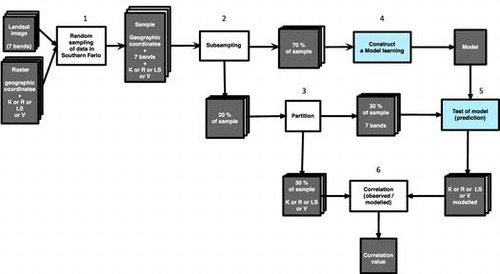
Graphical Abstract
Acknowledgements
This work has been initiated within the framework of ORIXAS project coordinated by France, Brazil and Africa. We are grateful to all the partners and authors involved in this program.
Notes
No potential conflict of interest was reported by the authors.
1 Performed within the framework of ORIXAS program: ‘Observatoires Régionaux Intégrès des milieuX Arides, Semi-arides et sub-humides secs, 2014–2015’. Three partners Africa, Brazil and France are involved in this research program according to the call ‘Combating desertification in Africa; Promoting de la food security and poverty reduction’.