Abstract
This paper describes the development of agricultural land cover maps with 5 × 5 minute resolution based on satellite data and agricultural statistics from the Food and Agriculture Organization (FAO) for the period 1990–2000. Consistency with the FAO data allows for reconstructing past changes and developing scenarios for future changes in land cover. Two base maps were used: (1) the International Geosphere–Biosphere Programme (IGBP) map based on DISCover data using the IGBP classification; (2) the Global Land Cover (GLC) map based on the Global Land Cover 2000 VEGA2000 data. The underlying DISCover data from the seasonal land cover regions were used to allocate the areas of cropland and grassland for the IGBP map. For the GLC map no such data were available, so a trial and error approach was used. While neither of the two base maps completely matched the FAO country data, combination of the IGBP and GLC maps resulted in a satisfactory match with FAO data for all countries. Apart from noise in the data, interpretation problems and uncertainties in the ancillary data used in interpretation, a major problem in allocating grasslands is the broad definition used by FAO, allowing for important differences between countries in the type of grassland included in the statistics. Comparison with Holdridge life zones showed that a large part (∼40%) of global grassland occurs in semi deserts, deserts and sub-polar tundra's, regions with unfavorable climates with low productivity and low carrying capacity. However, the distribution of grasslands over life zones varies widely in different parts of the world. Cropland occurs in more favorable climates.
1. Introduction
The conversion of natural ecosystems to agriculture and other human activities have strongly modified the earth's terrestrial biosphere over the last three centuries (Klein Goldewijk, Citation2001; Lambin et al., Citation2003). The world's arable land area increased from roughly 3 million km2 in 1700 to 15 million km2 at present, while the pasture area increased more than sixfold from about 5 to 34 million km2 in the same period. Apart from the loss of natural ecosystems per se, these changes in land cover have resulted in changes in albedo and surface roughness, which have led to important changes in (regional) climate (Henderson-Sellers and Gornitz, Citation1984). Historically, conversion of natural ecosystems to agriculture has also been a major source of atmospheric CO2 (Houghton et al., Citation1983), one of the main driving forces of global climate change (IPCC, Citation2001). Moreover, land cover and land use changes have also led to changes of the biogeochemical cycles of water (Alcamo et al., Citation2003), carbon (Houghton, Citation2003), nitrogen (Galloway et al., Citation2004) and other nutrients.
To understand the interactions between regional and global land use and land cover and climate, many different types of models are used that require a description of the biophysical characteristics of the land's surface; for example, global circulation models (GCMs) (Cox et al., Citation1999). Other models use spatial land cover information to describe biogeochemical cycles and processes, such as global earth system models (Image-team, Citation2001b), hydrological models (Alcamo et al., Citation2003), atmospheric chemistry models (Ganzeveld et al., Citation2002), soil models (Del Grosso et al., Citation2000), and crop growth models (Tan and Shibasaki, Citation2003).
Before digital geo-referenced information became available there have been many different approaches to vegetation and land cover mapping (Emanuel et al., Citation1985; Unesco, Citation1973; Walter, Citation1985; Whittaker, Citation1975). The first global geo-referenced distributions of global land cover were developed more than two decades ago (). The 1 × 1 degree resolution data set developed by Hummel and Reck (Citation1979) aimed at improving estimates of albedo and served as a basis for the 0.5 × 0.5 degree resolution data set developed for studying the global carbon cycle (Olson and Watts, Citation1982; Olson et al., Citation1983). The data set of Matthews (Citation1983) was used in many different studies, while those presented by Wilson and Henderson-Sellers (Citation1985) were used in global climate model studies mainly ().
Table 1. Global digital land cover data sets
Most early digital data sets were compiled from various sources of information such as atlases, maps and statistics, and include natural and agricultural classes with varying level of detail. That of Matthews (Citation1983) was the first data set that was partly based on Landsat satellite imagery (). With other satellites and sensors available, DeFries and Townshend (Citation1994) presented a global 1 × 1 degree resolution data set based on a comparison of advanced very high resolution radiometer (AVHRR) normalized difference vegetation index (NDVI) data with ground-based data, resulting in 11 land cover types including cropland and 2 types of grassland ().
More recently, a number of global land cover data sets were developed using the International Geosphere–Biosphere Programme Data and Information System (IGBP-DIS) Global 1 km Land Cover Data Set (DISCover) data (Loveland and Belward, Citation1997; Loveland et al., Citation2000). The DISCover data were derived from monthly NDVI data for the early 1990s by different classification procedures relying on ancillary data such as digital elevation models and climate data using different legends for all land cover types including natural ones. The DISCover classification was defined (amongst others) to meet the requirements of the IGBP core science projects.
On the basis of DISCover, Ramankutty and Foley (Citation1998) presented a data set representing the distribution of croplands for the early 1990s with global 5 × 5 minute (∼9 km at the equator) resolution. Although the DISCover data were combined with a variety of national and sub-national agricultural inventory data (primarily from Food and Agriculture Organization (FAO) (Citation1995)), Ramankutty and Foley (Citation1998) recognized that their global cropland area is much larger than that of FAO. Leff et al. (Citation2004) elaborated on the work of Ramankutty and Foley to develop global data sets of the spatial distribution of 18 major crops across the world. To our knowledge there is only one DISCover-based data set for global grassland (Foley et al., Citation2003, Citation2005).
Apart from these global data, there are also spatial land cover data sets for large countries and continents, for example China (Frolking et al., Citation2002), USA (Loveland et al., Citation1991; Waisanen and Bliss, Citation2002), Africa (Townshend and Justice, Citation1986; Tucker et al., Citation1985), Europe (Environment Topic Centre of European Environment Agency, Citation2005), and South America (Townshend et al., Citation1987).
Grassland makes up ∼70% of the global agricultural area and it is known to play a major role in biogeochemical cycles and climate (Asner et al., Citation2004). For model studies of historical and future land cover (Klein Goldewijk, Citation2001), and modeling of changing global climate and biogeochemical cycles, for example with the Integrated Model for the Assessment of the Global Environment (IMAGE) (IMAGE-team Citation2001a), we need to know the spatial distribution of both cropland and grassland. The recent global satellite-based inventories (Loveland et al., Citation2000) concentrate mainly on cropland and they lack of a thorough analysis of the global distribution of grassland and its use. This calls for a consistent approach, which reconciles reported statistics for croplands and grassland and the remote sensing maps.
There are many difficulties associated with the use of satellite-based interpretations of land cover.
-
Differences in quality and reliability ancillary data (elevation, climate, urban areas) between continents and regions which may cause errors in the land cover map produced.
-
Artifacts such as the presence of clouds, data gaps, faulty registrations and other errors in the registered signal. The extent to which noisy data are manifested within different maps is unknown.
-
The occurrence of mosaics of different land cover types. Agricultural land often occurs in landscapes in combination with other land cover types ranging from natural to intensively managed ones, and boundaries may be diffuse. This problem occurs in all recent land cover maps based on satellite observations (Hansen and Reed, Citation2000). The resolution of the satellite data (1 km for AVHRR–NDVI) may be appropriate for detecting homogeneous cropland or grassland such as in the mid-west of the USA. The resolution of the satellite data may be inadequate for distinguishing small farmer plots occurring in mosaics with other land cover types and this may lead to over- or underestimation of the agricultural area of up to 30% (F. Achard, personal communication, 2005).
-
The variety of definitions used for grassland. Grassland ecosystems representing natural plant associations range from savannas (Africa, South America and India), to steppe (Eurasia), prairies (North America), and (semi-)deserts (China, Australia) (Breymeyer, Citation1990). These systems have widely varying intensities of use (Asner et al., Citation2004), from intensive management in some temperate regions to extensive use in steppe, high-altitude grasslands and savanna/shrub/semi-desert areas in the tropics and subtropics. Permanent managed grassland includes permanent meadows, permanent pastures and alternating meadows and pastures. Permanent meadows are mostly mown (though when the growth is not sufficient they serve as a grazing area). Permanent pastures (often referred to as rangeland) are used exclusively or predominantly for grazing. Alternating meadows and pastures are used as a grazing area after the first mowing. Leys are generally cropland areas temporarily sown with grass. Leys may cover a considerable fraction of the cropland area in some countries such as Sweden and Ireland (Dziewulska, Citation1990; Lee, Citation1988). Due to their temporary nature, there is no clear distinction between leys and cropland. Based on the physiognomy, grassland is land covered with grass and other herbaceous plants. In many places grassland may even be dominated by herbaceous species (FAO, Citation2005). With this definition of grassland, FAO (Citation2005) probably includes all the above types of grassland, and it is not clear if interpreters of the satellite data have had similar definitions.
-
Fallow areas. ‘Arable land and permanent crops’ as defined in FAO (Citation2005) includes fallow land, which may make up a considerable fraction of total cropland in some parts of the world. It is not clear to what extent these areas are accounted for in the interpretations of satellite data.
The aim of this study is to develop global 5 × 5 minute resolution maps of cropland and grassland. For global modeling of land cover a requirement is that the maps are consistent on a country scale with published international statistics on land use including agricultural production characteristics and land cover. We present a global data set of the distribution of cropland and managed grassland representing the current situation (1990–2000). This data set is based on different satellite sensors and interpretation methods, and reconciles the statistical inventories for cropland and grassland of FAO (Citation2005) with satellite imagery in a consistent way.
2 Methods and data used
Two base maps were used in this study. The first map is derived from the DISCover map developed by Loveland et al. (Citation2000) based on satellite data representing two years of observation (1992–1993) from the AVHRR satellite sensor, using the 12 monthly maximum NDVI values which are regarded as a representation of the annual phenology of the vegetation (Loveland et al., Citation2000). The raw data were clustered using an unsupervised classification algorithm and labeled at a continental scale, and then checked and refined using a variety of other maps and atlases (Loveland et al., Citation2000). We used the International Geosphere–Biosphere Programme (IGBP) version 2 land cover classification system (further referred to as IGBP) with a 1 × 1 km resolution. There are other maps available such as United States Geological Survey (USGS) (Citation2000) and Hansen and Reed (Citation2000). However, these maps were considered less appropriate for our purposes because the legend used was not specifically designed to delineate croplands and grassland separately.
The second map is the Global Land Cover 2000 (GLC) with ∼0.5 minute resolution derived by Bartholome et al. (Citation2002) from the VEGA2000 data set with a daily global image from the Vegetation sensor onboard the SPOT4 satellite representing the year 2000. The land cover classification system of FAO and United Nations Environment Programme (UNEP) (Di Gregorio and Jansen, Citation2000) was used to classify this data set into land cover classes.
The IGBP land cover classification system has 17 classes. The GLC map has 23 land cover classes, only 3 of them containing cropland by definition. The GLC legend is not specific about the cropland and grassland fractions in each class. Both maps were aggregated to a 5 × 5 minute grid. This resolution is a compromise between the resolution of current earth system models and GCMs and the original satellite data, and where necessary data can always be further aggregated.
We used the data to make a distinction between cropland and grassland. Assuming that over this relatively brief period of one decade no major shifts of broad agricultural areas have taken place (Bouwman et al., Citation2005), the two maps can be used to represent the whole 1990–2000 time period. Any changes that occurred in this period are thus assumed to have taken place within the grid cells with cropland or grassland by increasing percentage of coverage or by increasing intensity of use (for example, increasing cropping intensity or number of harvested crops per year).
Many classes in the base maps are associations of cropland, grassland and other land cover types. The exact percentage of each land cover type within these associations is not reported. Therefore, the Seasonal Land Cover Region (SLCR) (Loveland et al., Citation2000) data was used for interpretation of the classes of the DISCover data set (). SLCR land cover types are continent-specific and definitions are not standardized between continents. The SLCR are the fundamental spatial unit of the database, and it has many cropland categories and mixed classes with cropland, grassland and natural vegetation in various combinations (205 classes for North America, 167 for South America, 197 for Africa, 255 for Eurasia, and 137 for the Australia–Pacific region). Overlaying SLCR with the IGBP map allows for estimating the cropland/grassland fraction of each sub-category.
Table 2. Summary of the four steps for compiling the final coverage for cropland and grassland
Because our main purpose is the analysis of historical and future land cover distributions, agricultural production and land use, and consequences for climate and biogeochemical cycles, the data need to be consistent with global historical FAO data (FAO, Citation2005) and projections (Bruinsma, Citation2003). For the base year our results may therefore differ from Ramankutty and Foley (Citation1998) and Leff et al. (Citation2004), who used sub-national data for many countries (although the sub-national sums were corrected by Leff et al. (Citation2004) to be consistent with the FAO (Citation1995) data).
Because the satellite data cover the period 1990–2000, the year 1995 was selected as the reference year for normalizing. We used the mean of 1993–1997 data as reported for each country by FAO (Citation2005) to represent areas of ‘arable land and permanent crops’ and ‘permanent pasture’ for the reference year 1995 (hereinafter referred to as FAOSTAT) (). We assumed that ‘permanent pasture’ refers to all managed grasslands excluding leys, even though in many parts of the world grassland may be marginal and extensively used as expressed by low animal densities (Asner et al., Citation2004).
Table 3. Five-year running mean of areas of permanent pasture and arable land and permanent crops taken from (FAO, Citation2005)
Our analysis for each of the two base maps consisted of three steps (), including the exclusion of areas of water, snow, ice, urban and wilderness areas (step 1), the estimation of the occurrence of cropland and grassland in all land cover classes and generation a cropland and grassland map (step 2), and normalization (calibration) of the step 2 maps with FAOSTAT data (step 3). In step 4 the resulting maps for cropland and grassland were combined ().
Step 1. In the first step we excluded the classes ‘Snow and ice’, ‘Urban and built-up’ and ‘Water bodies’ from the 17 original classes of the IGBP map, and the classes ‘Water’, ‘Snow and ice’, and ‘Artificial surfaces’ were excluded from the GLC map. Exclusion of these classes yielded the available land surface area for allocation of cropland and grassland per grid cell.
Although forest or other land cover types were not excluded, we did exclude areas known as ‘wilderness’ or undeveloped land which is still primarily shaped by the forces of nature using data provided by McCloskey and Spalding (Citation1989). The base maps used to delineate wilderness areas were the Jet Navigation Charts (scale 1:2,000,000) and Operational Navigation Charts (scale 1:1,000,000). In constructing the map of wilderness all areas with roads, settlements, airports and other constructs were eliminated. Areas of agricultural development and logging were excluded as well as proximity zones of 6 km distance around roads and settlements. Finally, all remaining wilderness areas with a surface area less than 400,000 km2 were excluded. With this definition, about one-third (50 million km2) of the global land area is wilderness, with vast areas in Antarctica, Eurasia, Africa, and North America. Individual countries with major wilderness areas are the Commonwealth of Independent States (CIS) (34% of the land area), Canada (65%), Australia (30%), Greenland (99%), China (Tibet) (24%), Brazil (24%), Algeria (59%), Mauritania (69%) and Saudi Arabia (28%).
Because of the broad definition of grassland used by FAOSTAT we could not exclude all wilderness areas delineated by McCloskey and Spalding (Citation1989). Wilderness areas in the tropics such as deserts, grassland savannas, and pampas, and steppe and prairie areas in temperate regions can potentially be used for pastoral grazing, and were therefore not excluded from our base maps. With highly unfavorable climatic conditions, the wilderness areas occurring in cold climates (> 50° latitude) in the Russian Federation and Canada were excluded for allocation of agriculture.
Step 2. The second step involved the estimation of the fractions of cropland and grassland within each class of the IGBP map on the basis of a comparison with the SLCR maps. First, we selected all classes dominated by cropland and grassland. Secondly, classes containing combinations of cropland, grassland and other land cover types were added.
For the GLC map we had no underlying satellite data available. We therefore selected a number of classes containing cropland or grassland and estimated fractions of cropland/grassland in these classes by trial and error and by comparing the (national) coverages with FAOSTAT and by comparing spatial patterns with other maps.
In step 1 we already excluded areas of snow, ice, water and built-up areas from each grid cell to determine the maximum available area for cropland and grassland. We constructed the cropland map prior to the one for grassland, and used the following criteria to avoid double usage of the area within a grid cell. (1) The sum of the cropland and grassland area can not exceed the maximum available area within a grid cell. (2) The total country cropland and grassland area can not exceed the FAOSTAT data.
Step 3. For those countries where after step 2 the cropland and grassland maps underestimated the FAOSTAT data, step 3 involved the normalizing (calibration) of the maps with FAOSTAT data. Normalization is defined here as multiplication of all the cropland areas in the grid cells of a country by a factor [0.5–2.0], complying with the maximum available area. We assumed an arbitrary maximum value of 2 because higher values would be unacceptable without further in-depth investigation of the causes of mismatch at the scale of countries.
Initially, we did not use sub-national data, because of the lack of consistent historical time series of agricultural statistical data for many countries, and the difficulty to develop consistent scenarios at the sub-national scale. However, when using national data, a considerable area of grassland was allocated in China in the intensely cropped eastern part of the country, and a similar problem occurred in the USA. Therefore, we decided to use the available agricultural census data on province (China) or state (USA) level for these two countries and this improved the overall agreement with other sources of information such as Suttie et al. (Citation2005).
Step 4. The base maps from steps 2 and 3 were combined in different ways for cropland and grassland in order to obtain a map which matches the FAOSTAT data better than each of the individual base maps (). Subsequently, we neglected cropland areas occurring in grid cells with a cropland percentage less than 1% (filtering), primarily in sparsely populated areas tropical rainforests of Africa, the Amazon basin and in mountainous regions. We consider them to be errors (noise) of the satellite observations, or agricultural land (such as land under shifting cultivation) which is not included in FAOSTAT data (Smil, Citation1999).
To prevent unrealistic occurrence of cropland in areas with very short growing periods due to low temperatures, we corrected the previous result using a weighting factor based on the annual sum of growing degree days (). A map for growing degree days was derived from the mean monthly air temperatures for the period 1960–1990 from New et al. (Citation1999). Daily mean air temperatures were estimated by linear interpolation between mid-monthly values.
We compared our 5 × 5 minute grid cell map with the Ramankutty and Foley (Citation1998) by calculating the matching-area fraction m, proposed by Wilmott et al. (Citation1985):
3 Results
3.1 IGBP
3.1.1 IGBP cropland
We first analyzed the occurrence of cropland and grassland in the IGBP map by overlaying the original 1 × 1 km resolution maps with the SLCR map. An example for Africa is presented in showing the areas of different SLCR classes within IGBP classes ‘Grassland’ (class 10), ‘Cropland’ (class 12) and ‘Cropland/Natural vegetation’ (class 14). It is clear that in compiling the IGBP map many different natural vegetation types, grassland and cropland were combined in the final legend entries. For example, 27% of the ‘Grassland’ class contains unspecified areas of cropland, and 42% of the ‘Cropland’ contains unspecified areas of pasture and grassland. ‘Unspecified’ (e.g. the addition ‘with cropland’) means that the SLCR land cover class description is not specific about the exact areas.
Table 4. Area of the SLCR classes within the IGBP map for Africa for class 10 (grassland), class 12 (cropland), and class 14 (cropland/natural vegetation) based on overlay of 1 × 1 km resolution maps
For the IGBP-based cropland map we included 81% of ‘Cropland’ and 17% of ‘Cropland/Natural vegetation’ (). We did not include a fraction of ‘Grassland’ (class 10) in the cropland map, because in some countries (e.g. Argentina) this would yield diffuse areas of cropland in regions known to be dominated by grassland (pampas) (Suttie et al., Citation2005). This yielded a global area of 14.3 million km2 of cropland, which is about 6% less than the area of 15.2 million km2 of arable land and permanent crops reported by FAOSTAT ().
Table 5. Fractions of land cover classes used for the allocation of cropland and grassland for the IGBP and GLC base maps
Cropland was underestimated for 44 countries, mainly in North America, North Africa and the Middle East. For these countries extra cropland area was included from (in this order) 4% of ‘Woody savanna’ (class 8), 2% of ‘Deciduous broadleaf forest’ (class 4), and 2% of ‘Closed shrubland’ (class 6) (). Adding these areas increased the global cropland area by 400,000 km2 to 14.7 million km2, which is still about 3% less than FAOSTAT.
The next step, normalization to achieve a better match with FAOSTAT, added another 270,000 km2. However, the match with FAOSTAT was still not perfect, the cropland area still being underestimated in many countries in North Africa and the Middle East, and in Sweden, Finland and Jamaica ().
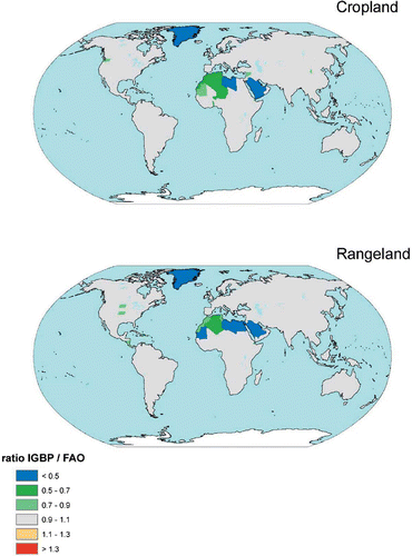
Figure 1. Ratio calculated areas per country obtained in step 3 for IGBP for cropland (top panel) and grassland (bottom panel). (Available in colour online)
3.1.2 IGBP grassland
The global area of IGBP-class ‘Grassland’ (class 10) is 10.6 million km2, which is less than one-third of the global ‘permanent pasture’ area of 34.6 million km2 for 1995 (). From the analysis of ‘Cropland’ (class 12) and ‘Cropland/Natural vegetation’ (class 14) we found that these classes contain considerable areas of grassland. Therefore, we composed a grassland map by selecting 76% of the ‘Grassland’ class, 12% of ‘Cropland’, 48% of ‘Cropland/Natural vegetation’ and 51% of ‘Woody savanna’ (class 8) (). This yielded a global grassland area of 19.8 million km2, which is less then 60% of the area reported by FAOSTAT for 1995 (). The grassland area is underestimated in most countries except for countries in Northern and Eastern Europe and the former Soviet Union.
We analyzed the overlays for each (sub-)continent and concluded that the IGBP-based grassland map should include large areas of savanna, shrubland, bushland, semi-desert and other land use types in order to match the FAOSTAT data (). For countries where the grassland area was underestimated, we added grassland areas by including 10% of the class ‘Deciduous broadleaf forest’ (class 4), 16% of ‘Closed shrubland’ (class 6), 33% of ‘Savanna’ (class 9), and 38% of ‘Open shrubland’ (class 7) (). This resulted in a global grassland area of 30.8 million km2. This is ∼12% less than the FAOSTAT data () due to underestimation in a large number of countries in North and South America, Africa, the Middle East, Asia and Australia.
The next step was to normalize the grassland map with the FAOSTAT data for permanent pasture areas. This increased the global grassland area to 32.7 million km2 which is still ∼5% less then FAOSTAT caused by underestimation which persisted in many countries in South America, North and Sub-Saharan Africa, the Middle East, China and Mongolia, and Australia ().
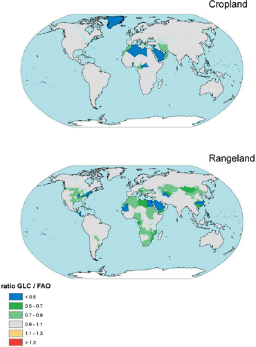
Figure 2. Ratio calculated areas per country obtained in step 3 for GLC for cropland (top panel) and grassland (bottom panel). (Available in colour online)
3.2 GLC
3.2.1 GLC cropland
From the 23 GLC land cover classes, only three include cropland by definition. We included 68% of the class ‘Cultivated and managed areas’ (class 16), 33% of ‘Cropland/tree cover/natural mosaic’ (class 17), and 20% of ‘Cropland/shrub or herbaceous cover’ (class 18). Class 23 (undefined, representing a number of minor Pacific islands) was added for completeness (). This yielded a global cropland area of 18.2 million km2 with overestimation in many countries (South America, Western Europe, Africa, Southeast and East Asia), and underestimation in many other countries (North America, North Africa and the Middle East). First we reduced the cropland area for countries with overestimation to match FAOSTAT, resulting in a global cropland area of 13.5 million km2. We then added fractions of the class ‘Herbaceous cover, closed/open’ (13) to obtain a better match with FAOSTAT for countries with underestimation. This proved especially effective in the USA, where apparently minor areas of cropland occur within regions dominated by rangelands. The resulting global cropland area was 14.1 million km2, which is about 7% less then FAOSTAT.
We then normalized again with FAOSTAT to reduce the underestimation. This yielded a global cropland area of 14.9 million km2, which is only 2% less than the area reported by FAOSTAT. Underestimation persisted in the USA, and a number of countries in North Africa and the Middle East ().
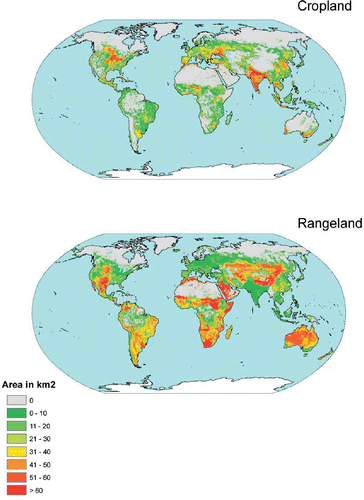
Figure 3. Combined 5 × 5 minute resolution global map of cropland (CROPmap6) and grassland (GRASSmap6). (Available in colour online)
3.2.2 GLC grassland
Apart from the GLC land cover classes with cultivated and managed areas and cropland, that also contain grassland (), we added fractions of many other classes to compile our grassland base map. We included 7% of the class ‘Cultivated and managed areas’ (class 16), 21% of ‘Cropland/tree cover/natural mosaic’ (class 17), 46% of ‘Cropland/shrub or herbaceous cover’ (class 18), 37% of ‘Shrub cover, closed/open, deciduous’ (class 12), 72% of ‘Herbaceous cover (closed/open)’ (class 13), 57% of ‘Sparse herbaceous and sparse shrub cover’ (class 14) and 24% of ‘Regularly flooded and/or herbaceous cover’ (class 15). This yielded a global grassland area of 30.3 million km2, about 12% less than the 34.6 million km2 of FAOSTAT (). However, in many countries grassland areas were strongly overestimated, especially in Canada, Europe and the Russian Federation. When we normalized the area of grassland for countries where grassland areas exceeded those reported by FAOSTAT, only 26.1 million km2 of grassland remained.
Normalizing grassland areas for countries with underestimation compared to FAOSTAT resulted in a global grassland area of 29.3 million km2, which is 15% less than FAOSTAT with clear underestimation in the Eastern part of the USA, Bolivia, Kazakhstan, Mongolia, Southeastern part of China, Africa and the Middle East ().
3.3 Combination of base maps
Neither the IGBP nor the GLC maps for cropland and grassland matched FAOSTAT data in many countries (). Problems of underestimation of cropland and grassland in each of the maps occurred in different parts of the world. This indicates that combination of the areas with high probability of occurrence of cropland and managed grassland could lead to a better agreement. Various methods for combining the base maps for cropland and grassland were tested.
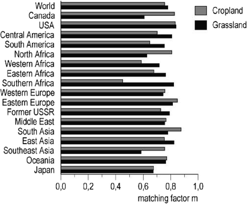
Figure 4. Matching area in percent for the Ramankutty and Foley (Citation1998) cropland map (after normalization with FAOSTAT 1990–1995 data) and our final map for cropland; and the Foley et al. (Citation2005) grassland map (after normalization with FAOSTAT 1993–1997 averaged data) and our final map for grassland. See Equationequation (1)1 for the calculation of the matching area.
3.3.1 Cropland
We first calculated the average of the cropland areas per grid cell in the pre-normalization IGBP and GLC base maps (CROPmap1, ) yielding a global cropland area of 14.4 million km2. Normalization of this map in order to better match FAOSTAT (CROPmap2, ) increased the global cropland area to 15.04 million km2. This is close to FAOSTAT (), but cropland areas were still underestimated in a number of countries in North Africa and the Middle East.
A third map was generated by first averaging the normalized IGBP and GLC base maps and then normalizing the result (CROPmap3, ). This yielded a global total cropland area of 15.10 million km2. Underestimation persisted in North Africa and the Middle East. Subsequently we selected for each grid cell the largest cropland area from the normalized base maps of IGBP and GLC and then normalized again (CROPmap4, ). The global cropland area was increased by 40,000 km2 to 15.14 million km2, indicating that maximizing cropland area per grid cell is effective for solving problems of underestimation in North Africa and the Middle East. We therefore decided to use a mixture of cropland found by averaging (CROPmap3) and maximizing (CROPmap4) giving CROPmap5 ().
Finally, we filtered out cropland areas in very small percentages (<1%) of the grid cell area and normalized again. Although the problem of underestimation of cropland area was not completely solved, we consider the resulting map as the best possible combination (CROPmap6). Using a weighting procedure () we reallocated cropland from cold areas with a short growing season to parts in the same country where cropland is more likely to occur ().
3.3.2 Grassland
The procedure for compiling the grassland map is similar to that for cropland (). We accounted for the maximum area available for grassland in each grid cell to avoid allocation of grassland in areas of cropland. Averaging of the (pre-normalization) base IGBP and GLC maps yielded a global grassland area of 28.1 million km2 (GRASSmap1). The global grassland area was increased by normalization to 32.31 million km2 (GRASSmap2) but the grassland area was still underestimated compared to FAOSTAT for a number of countries in North Africa, the Middle East, and in Australia and China. Averaging the normalized base maps (GRASSmap3) did not solve this problem, while maximizing the normalized base maps was more effective and resulted in a global grassland area of 32.99 million km2 (GRASSmap4). However, in several countries the problem of underestimation of grassland was not solved.
A mixture for each grid cell of the average and the maximum of normalized base maps (GRASSmap5) was corrected by filtering out grassland areas occurring in very small percentages (<1%) of the grid cell area and normalizing again (GRASSmap6). This yielded a global grassland area of 33.4 million km2. In GRASSmap6 underestimation of the grassland area compared to FAOSTAT persisted for countries in North Africa, the Middle East, and China and Mongolia. Finally, we moved grassland from remote areas with unsuitable climatic conditions to regions with more suitable climatic conditions ().
4 Discussion
4.1 Cropland
Our final global map () for cropland is 100% consistent with the FAOSTAT average for 1993–1997 areas of ‘arable land and permanent crops’. The broad patterns in our map are consistent with more detailed studies for Africa (Townshend and Justice, Citation1986; Tucker et al., Citation1985), Europe (Environment Topic Centre of European Environment Agency, Citation2005), South America (Townshend et al., Citation1987), China (Frolking et al., Citation2002), and USA (Loveland et al., Citation1991; Waisanen and Bliss, Citation2002).
In comparing this map with the one of Ramankutty and Foley (Citation1998) (both maps have a 5 × 5 minute resolution) we first note that while our map is consistent with FAOSTAT, the coverage of Ramankutty and Foley (Citation1998) is not in many countries. For example, the cropland area was overestimated by Ramankutty and Foley (Citation1998) compared to average 1990–1995 FAOSTAT data in most of the former Soviet Union, Mongolia, China, Chile, Bolivia, a number of Eastern and Southern African countries, UK, the Netherlands, Belgium, and some Middle and Eastern European countries by a factor of 1.5 or more. Apart from countries with a slight over- or underestimation (for example, USA, Argentina, Egypt, Australia) there are also many countries where Ramankutty and Foley (Citation1998) underestimated the cropland area by more than a factor of 2 (Sweden, Saudi Arabia, Yemen, Libya, Tunisia, Chad, Niger, Central African Republic, Cameroon, Nigeria, Benin, Togo, Ivory Coast, Liberia, Sierra Leone, Mauritania). It is not clear what caused these differences with FAOSTAT. For example, for China Ramankutty and Foley (Citation1998) estimate a total cropland area of 2.05 million km2 and FAOSTAT reports only 1.3 million km2. The latter estimate is in line with the reported arable land area for China of 1.25 million km2 for 1989 (Alexandratos, Citation1995) and the adjusted area of 1.34 million km2 for 1998 (Bruinsma, Citation2003). This adjustment is based on various sources of information including (sub-)national statistics. Hence, there are other causes for the discrepancy of Ramankutty and Foley (Citation1998), such as the inclusion of 100% of the IGBP class ‘cropland’. In contrast, since this IGBP class includes many other land cover types (), we assigned only 81% of this class to cropland.
To avoid mismatches due to inconsistency with FAOSTAT, we first normalized the Ramankutty and Foley (Citation1998) cropland map with FAOSTAT mean 1993–1997 data, and then calculated the matching area for the two maps according to Equationequation (1)1 (). By using the SLCR information to select all classes with cropland, and by combining data from different sensors we arrived at a global distribution that differs from the approach of Ramankutty and Foley (Citation1998). Clear differences between the maps are in Eastern, Western and Southern Africa, with a match ranging from 45 to 68%, thus indicating that there is disagreement about the location for 32–55% of the cropland area. For East Asia there is agreement for about 75% of the cropland area. This apparent good agreement is mainly due to the fact that Chinese croplands are largely confined to the Eastern part of the country, irrespective of the classes included in the map. Other regions with less than 70% agreement are South America (65%) and Japan (68%).
The overlay of CROPmap6 with the map of Holdridge Life Zones indicates that about 11% of global cropland occurs in semi-desert and desert areas, and this is probably primarily land under irrigation. Large cropland areas occur in subtropical and tropical forest and woodland zones, and temperate forest zones ().
4.2 Grassland
Our final global grassland map () is consistent with FAOSTAT data for ‘permanent pasture’ except for a few countries and in good agreement with (Suttie et al., Citation2005), maps and descriptions for many countries provided in FAO/University of Queensland ‘Country Pasture Profiles’ (data available from www.fao.org/ag/AGP/AGPC/doc/pasture/forage.htm), and data for China (Chen and Fischer, Citation1998).
We made a comparison with the recent inventory of global grasslands presented by Foley et al. (Citation2005). For that purpose we first compared the grassland map of Foley et al. (Citation2005) with FAOSTAT mean 1993–1997 data and noted a good agreement (less than 10% difference) for USA, Brazil, Mali, Ivory Coast, Congo Democratic Republic, Somalia, Ukraine, Kazakhstan, Mongolia, Australia and New Zealand. However, grassland areas are overestimated by more than 50% in many African countries (Ethiopia, Central African Republic, Cameroon, Niger, Burkina Faso, Togo, and Benin) and Asian countries (Turkey, Iraq, Iran, Pakistan, India, Myanmar, Malaysia, Indonesia, Papua New Guinea, Japan, North Korea and South Korea). Moreover, there are many countries with underestimation of grassland areas by more than 50%, mainly in Western Europe and North Africa.
This comparison suggests that while cropland areas are overestimated by Ramankutty and Foley (Citation1998) in many western and eastern European countries, grassland areas are underestimated by Foley et al. (Citation2005) in the same countries. This supports our conclusion that in many European countries cropland and grassland occur in mosaics in mixed crop–livestock production systems, and that including 100% of the IGBP class 12 (croplands) leads to overestimation of cropland and underestimation of grassland areas.
We normalized the Foley et al. (Citation2005) grassland map with FAOSTAT mean 1993–1997 data to compare spatial patterns proper. This was successful in most countries except for North Africa and Saudi Arabia, where the underestimation of grassland persisted after normalization. We then calculated the matching grassland areas in this normalized map and our final grassland map (). It is clear that the global grassland area in the Foley et al. (Citation2005) map (31.6 million km2 prior to and 32.5 million km2 after normalizing) is close to the FAOSTAT data and our estimate from the final grassland map (33.4 million km2).
However, the spatial patterns differ. We found a relatively poor agreement for Canada (64%), Northern Africa (63%), Southeast Asia (58%), and Japan (64%). World regions with a good match (>75%) include the USA, Central and South America, the former Soviet Union, Eastern and Southern Africa and South and East Asia.
The global match for grassland (78%) about equals that for cropland (76%). However, there are large differences between regions. For example, for Canada and North Africa the matching area for grassland is much smaller than that for cropland, while the agreement between the two grassland maps is much better for grassland than for cropland in Western, Eastern and Southern Africa (data not shown).
Overlaying GRASSmap6 with a map of Holdridge Life Zones (Smith et al., Citation1992) indicates that grasslands occur in a wide variety of environmental conditions (). A major part of the global grassland area obtained with our approach occurs in desert and scrub and thorn woodland zones and sub-polar regions (∼40%) (). Grassland productivity in these life zones is probably low compared to that in other life zones, and in these regions pastoral extensive small-ruminant production systems are found (Suttie et al., Citation2005). For example, in China a large part of the ‘permanent pasture’ areas occur in zones with a carrying capacity of <0.5 sheep units per hectare for example in the Quinhai–Tibet plateau (Verburg and Van Keulen, Citation1999) although actual stocking rates may exceed this carrying capacity (Suttie et al., Citation2005). In Russia, more of the ruminant livestock production is in mixed temperate regions, probably concentrated in the cool steppe zone (Seré and Steinfeld, Citation1996).
Table 6. Occurrence of grassland and cropland within Holdridge Life Zonesa
4.3 Uncertainties
We recognize that our approach does not necessarily lead to a perfect distribution of croplands and grassland. There are many uncertainties involved in mapping of global agricultural land cover, the major ones related to the input data and classification methods, and the definition of grassland in the statistical information used.
Regarding the input data we already discussed the difficulty in separating crops and grassland by using satellite sensor data. This is caused by the occurrence of crops and grassland in mixed systems, where it is often difficult to distinguish between the two land cover types on the basis of the signal and its seasonality. Also, in climates with strong seasonality of rainfall the growing season of cereals and grass may cover the same period and reflect in the same wavelengths. In dry seasons soils may have a low coverage giving similar problems.
The definition of grassland in statistics is another problem. Grasslands occur in a variety of climates (), and it is not clear if all countries use the same definitions for ‘permanent pasture’ when they report to FAO. Correction up to 200% was necessary in many countries to match the maps with FAOSTAT. However, the opposite may be true that in some cases the FAOSTAT data are correct, while the interpretations of the satellite data are not.
Finally, areas designated for nature reserves or protected areas may or maybe not included in the definition of permanent pastures of FAO in some countries. For example, national Australian reports (National Land and Water Resources Audit, Citation2001) indicate that the area of permanent pastures in FAOSTAT for Australia includes a range of land tenures, and many of these are actually located in the ‘wilderness areas’ that we excluded from the available area for allocation.
5 Conclusions
We have constructed cropland and grassland maps with a 5 × 5 minute resolution based on satellite data and agricultural statistics from FAO for the period 1990–2000. Our approach combines the IGBP DISCover data with another satellite product, and from IGBP DISCover we combine the classes dominated by cropland and grassland with mixed classes, compared to confining to the dominant classes alone in the maps recently presented by Ramankutty and Foley (Citation1998) for cropland and Foley et al. (Citation2005) for grassland. As a result, the spatial distribution of cropland and grassland in our final maps is different. The match is good for countries with large areas of pure cropland or grassland; for example, the mid-west USA and the Eastern part of China, where the dominant classes alone also yield a realistic distribution. However, we see a poor match between the maps where cropland, grassland and other land cover types occur in mosaics; for example, the distribution of grassland in large parts of Africa.
The broad patterns of our maps are consistent with more detailed studies for Africa, Europe, South America, China, and the USA. We therefore conclude that our detailed allocation procedure for the IGBP data and the combination with the GLC data leads to a realistic global distribution of cropland and grassland. Our results are a useful set of land use maps for earth-system studies, and the consistency with the FAOSTAT data allows for reconstructing past changes and developing scenarios for future changes in land cover such as done by Alexandratos (Citation1995) and Bruinsma (Citation2003).
Faced with many difficulties in the interpretation of satellite imagery, such as the aggregation of globally widespread land use classes with the same ecological characterization, we stress the need for more emphasis on distinguishing agricultural production systems (ranging from extensive pastoral grasslands in semi-desert and desert zones to intensively managed pastures and meadows in mixed crop–livestock production systems) in future remote sensing studies.
The use of satellite information for adjusting statistical information as was done for Chinese cropland areas in the recent past could be a useful approach in other parts of the world where statistical information on agriculture is unreliable or not available.
Acknowledgements
The authors wish to thank Dr. Navin Ramankutty from the University of Wisconsin, Madison, for generously providing his preliminary global pasture map. This study was performed within the Integrated Terrestrial Environment Modeling project (M/S550005) at the Netherlands Environmental Assessment Agency (MNP).
Related Research Data
References
- Alcamo , J. , Döll , P. , Henrichs , T. , Kaspar , F. , Lehner , B. , Rösch , T. and Siebert , S. 2003 . Development and testing the WaterGap 2 model of water use and availability . Hydrological Sciences , 48 : 317 – 337 .
- Alexandratos , N. 1995 . World Agriculture: Towards 2010 , 488 Chichester : Wiley and Sons .
- Asner , G. P. , Elmore , A. J. , Olander , L. P. , Martin , R. E. and Harris , A. T. 2004 . Grazing systems, ecosystem response, and global change . Annual Review of Environmental Resources , 29 : 261 – 299 .
- Bartholome, E., Belward, A. S., Achard, F., Bartalev, S., Carmonamoreno, C., Eva, H., Fritz, S., Gregoire, J.-M., Mayaux, P. and Stibig, H.-J., 2002, GLC 2000; Global Land Cover mapping for the year 2000. Project status November 2002. Report EUR 20524 EN, Institute for Environment and Sustainability, Joint Research Centre, Ispra, Italy. Available online at: http://www-gvm.jrc.it/glc2000/defaultGLC2000.htm
- Bouwman , A. F. , Van Der Hoek , K. W. , Eickhout , B. and Soenario , I. 2005 . Exploring changes in world ruminant production systems . Agricultural Systems , 84 ( 2 ) : 121 – 153 . doi:10.1016 j.agsy 2004.05.006
- Breymeyer , A. I. 1990 . “ Managed grassland and ecological experience ” . In Managed Grasslands. Regional Studies , Edited by: Breymeyer , A. I. 335 – 350 . Amsterdam : Elsevier .
- Bruinsma , J. E. 2003 . World Agriculture: Towards 2015/2030. An FAO Perspective , 432 London : Earthscan .
- Chen , Y. and Fischer , G. A New Digital Georeferenced Database of Grassland in China . Tech. Rep. IR-98-062 . 1998 . International Institute for Applied Systems Analysis, Laxenburg
- Cox , P. M. , Betts , R. A. , Bunton , C. B. , Essery , R. L. H. , Rowntree , P. R. and Smith , J. 1999 . The impact of new land surface physics on the GCM simulation of climate and climate sensitivity . Climate Dynamics , 15 : 183 – 203 .
- DeFries , R. S. and Townshend , J. R. G. 1994 . NDVI-derived land cover classification at a global scale . International Journal of Remote Sensing , 15 : 3567 – 3586 .
- Del Grosso , S. J. , Parton , W. J. , Mosier , A. R. , Ojima , D. S. , Kulmala , A. E. and Phongpan , S. 2000 . General model for N2O and N2 gas emissions from soils due to denitrification . Global Biogeochemical Cycles , 14 : 1045 – 1060 .
- Di Gregorio , A. and Jansen , L. J. M. Land cover classification system . Classification concepts and user manual. GCP/RAF/287/ITA Africover . 2000 . Food and Agriculture Organization of the United Nations, Rome
- Dziewulska , A. 1990 . “ The spatial differentiation of grasslands in Europe ” . In Managed Grasslands. Regional Studies , Edited by: Breymeyer , A. I. 1 – 14 . Amsterdam : Elsevier .
- Emanuel , W. R. , Shugart , H. H. and Stevenson , M. P. 1985 . Climatic change and the broad-scale distribution of ecosystem complexes . Climatic Change , 7 : 29 – 43 .
- Environment Topic Centre of European Environment Agency . CLC technical documentation. Corine Land Cover 2000 project progress, European Topic Centre on Terrestrial Environment, Autonomous University of Barcelona (UAB), Barcelona . 2005 .
- FAO . AGROSTAT-PC, computerized information series. User manual, population, land use, production, trade, food balance sheets, forest products. Food and Agriculture Organization of the United Nations, Rome . 1995 .
- FAO, 2005, FAOSTAT database collections, Food and Agriculture Organization of the United Nations, Rome. Available online at: www.apps.fao.org
- Foley , J. A. , Costa , M. H. , Delire , C. , Ramankutty , N. and Snyder , P. 2003 . Green surprise? How terrestrial ecosystems could affect earth's climate . Frontiers in Ecology and Environment , 1 ( 1 ) : 38 – 44 .
- Foley , J. A. , DeFries , R. , Asner , G. P. , Bonan , G. , Carpenter , S. R. , Chapin , F. S. , Coe , M. T. , Daily , G. C. , Gibbs , H. K. , Helkowski , J. H. , Holloway , T. , Howard , E. A. , Kucharik , C. J. , Monfreda , C. , Patz , J. A. , Prentice , I. C. , Ramankutty , N. and Snyder , P. K. 2005 . Global consequences of land use . Science , 309 : 570 – 574 .
- Frolking , S. , Qiu , J. , Boles , S. , Xiao , X. , Liu , J. , Zhuang , Y. , Li , C. and Qin , X. 2002 . Combining remote sensing and ground census data to develop new maps of the distribution of rice agriculture in China . Global Biogeochemical Cycles , 16 : 1091 doi:10.1029/2002GB001425
- Galloway , J. N. , Dentener , F. J. , Capone , D. G. , Boyer , E. W. , Howarth , R. W. , Seitzinger , S. P. , Asner , G. P. , Cleveland , C. C. , Green , P. A. , Holland , E. A. , Karl , D. M. , Michaels , A. F. , Porter , J. H. , Townsend , A. R. and Vörösmarty , C. J. 2004 . Nitrogen cycles: past, present, and future . Biogeochemistry , 70 : 153 – 226 .
- Ganzeveld , L. N. , Lelieveld , J. , Dentener , F. J. , Krol , M. C. , Bouwman , A. F. and Roelofs , G. J. 2002 . Global soil biogenic NOx emissions and the role of canopy processes . Journal of Geophysical Research , 107 ( D16 ) : 4289 doi 10.1029/2001JD001289
- Hansen , M. C. and Reed , B. 2000 . A comparison of the IGBP DISCover and University of Maryland 1 km global land cover products . International Journal of Remote Sensing , 21 : 1365 – 1373 .
- Henderson-Sellers , A. and Gornitz , V. 1984 . Possible climatic impacts of land cover transformations, with particular emphasis on tropical deforestation . Climatic Change , 6 : 231 – 256 .
- Houghton , R. A. 2003 . Revised estimates of the annual net flux of carbon to the atmosphere from changes in land use and land management 1850–2000 . Tellus B , 55 : 378 – 390 .
- Houghton , R. A. , Hobbie , J. E. , Melillo , J. M. , Moore , B. , Peterson , B. J. , Shaver , G. R. and Woodwell , G. M. 1983 . Changes in the carbon content of terrestrial biota and soils between 1860 and 1980: a net release of CO2 to the atmosphere . Ecological Monographs , 53 : 235 – 262 .
- Hummel , J. and Reck , R. 1979 . A global surface albedo model . Journal of Applied Meteorology , 18 : 239 – 253 .
- Image-team . The IMAGE 2.2 implementation of the SRES scenarios. A comprehensive analysis of emissions, climate change and impacts in the 21st century , CD-ROM publication 481508018 . National Institute for Public Health and the Environment, Bilthoven 2001a
- Image-team . The Image 2.2 implementation of the SRES scenarios. Climate change scenarios resulting from runs with several GCMs , CDROM publication 481508019 . National Institute for Public Health and the Environment, Bilthoven, The Netherlands 2001b
- IPCC . 2001 . “ Third assessment report ” . In Working Group I , Cambridge : Cambridge University Press .
- Janssen , P. H. M. and Heuberger , P. S. C. 1995 . Calibration of process-oriented models . Ecological Modelling , 83 : 55 – 66 .
- Klein Goldewijk , K. 2001 . Estimating global land use change over the past 300 years: the HYDE database . Global Biogeochemical Cycles , 15 : 417 – 433 .
- Klein Goldewijk , C. G. M. and Batjes , J. J. A hundred year (1890–1990) database for integrated environmental assessments . Report 422514002 . 1997 . National Institute for Public Health and the Environment, Bilthoven, The Netherlands
- Lambin , E. F. , Geist , H. J. and Lepers , E. 2003 . Dynamics of land-use and land-cover change in tropical regions . Annual Review of Environmental Resources , 28 : 205 – 241 .
- Lee , J. 1988 . Forages . Livestock Production Science , 19 : 13 – 46 .
- Leff , B. , Ramankutty , N. and Foley , J. A. 2004 . Geographic distribution of major crops across the world . Global Biogeochemical Cycles , 18 : GB1009 doi:10.1029/2003GB002108
- Loveland , T. R. and Belward , A. S. 1997 . The IGBP-DIS global 1 km land cover data set, DISCover: first results . International Journal of Remote Sensing , 18 : 3291 – 3295 .
- Loveland , T. R. , Merchant , J. W. , Ohlen , D. O. and Brown , J. F. 1991 . Development of a land-cover characteristics database for the conterminous U.S . Photogrammetric Engineering and Remote Sensing , 57 : 1453 – 1463 .
- Loveland , T. R. , Reed , B. C. , Brown , J. F. , Ohlen , D. O. , Zhu , Z. , Yang , L. and Merchant , J. W. 2000 . Development of a global land cover characteristics database and IGBP DISCover from 1 km AVHRR data . International Journal of Remote Sensing , 21 : 1303 – 1330 .
- Matthews , E. 1983 . Global vegetation and land use: new high resolution data bases for climate studies . Journal of Climate and Applied Meteorology , 22 : 474 – 487 .
- McCloskey , J. M. and Spalding , H. 1989 . A reconnaissance level inventory of the amount of wilderness remaining in the world . Ambio , 18 : 221 – 227 .
- National Land and Water Resources Audit . Rangelands: an overview, National Land and Water Resources Audit, The National Heritage Trust, Commonwealth of Australia, Canberra . 2001 .
- New , M. , Hulme , M. and Jones , P. 1999 . Representing twentieth-century space-time climate variability. Part I: Development of a 1961–90 mean monthly terrestrial climatology . Journal of Climate , 12 : 829 – 856 .
- Olson , J. and Watts , J. A. 1982 . “ Major world ecosystem complexes (map, scale 1:30M) ” . In Carbon Dioxide review , Edited by: Clark , W. C. 388 – 399 . Oxford : Oxford University Press .
- Olson , J. S. Global ecosystem framework-definitions. USGS EROS Data Center Internal Report, Sioux Falls, South Dakota . 1994 .
- Olson , J. S. , Watts , J. A. and Allison , L. J. Carbon in live vegetation of major world ecosystems , ORNL 5862. Environmental Sciences Division, Publ. No.1997 . Oak Ridge National Laboratory, Oak Ridge, Tennessee. National Technical Information Service. U.S. Dept. Commerce 1983
- Parton , W. J. , Scurlock , J. M. O. , Ojima , D. S. , Gilmanov , T. G. , Scholes , R. J. , Schimel , D. S. , Kirchner , T. , Menaut , J. C. , Seastedt , T. , Moya , E. G. , Kamnalrut , A. and Kinyamario , J. I. 1993 . Observations and modeling of biomass and soil organic matter dynamics for the grassland biome worldwide . Global Biogeochemical Cycles , 7 : 785 – 809 .
- Ramankutty , N. and Foley , J. A. 1998 . Characterizing patterns of global land use: an analysis of global croplands data . Global Biogeochemical Cycles , 12 : 667 – 685 .
- Seré , C. and Steinfeld , H. World livestock production systems. Current status, issues and trends . Animal Production and Health Paper 127 . 1996 . Food and Agriculture Organization of the United Nations, Rome
- Smil , V. 1999 . Nitrogen in crop production: an account of global flows . Global Biogeochemical Cycles , 13 : 647 – 662 .
- Smith , T. M. , Leemans , R. and Shugart , H. H. 1992 . Sensitivity of terrestrial carbon storage to CO2-induced climate change: comparison of four scenarios based on general circulation models . Climate Change , 21 : 367 – 384 .
- Suttie , J. M. , Reynolds , S. G. and Batello , C. 2005 . “ Grasslands of the world ” . Plant Production and Protection Series 34 Rome : Food and Agriculture Organization of the United Nations .
- Tan , G. and Shibasaki , R. 2003 . Global estimation of crop productivity and the impacts of global warming by GIS and EPIC integration . Ecological Modelling , 168 : 357 – 370 .
- Townshend , J. R. G. and Justice , C. O. 1986 . Analysis of the dynamics of African vegetation using the normalized difference vegetation index . International Journal of Remote Sensing , 7 : 1435 – 1445 .
- Townshend , J. R. G. , Justice , C. O. and Kalb , V. T. 1987 . Characterization and classification of South American land cover types using remote sensing . Internation Journal of Remote Sensing , 8 : 1189 – 1207 .
- Tucker , C. J. , Townshend , J. R. G. and Groff , T. E. 1985 . African land-cover classification using satellite data . Science , 227 : 369 – 375 .
- Unesco . 1973 . International Classification and Mapping of Vegetation , 93 Paris : Unesco .
- United States Geological Survey, 2000, Global Land Cover Characterization (GLCC), classified according to U.S. Geological Survey Land Use/Land Cover System. Digital Data Series DDS-37, US Geological Survey. Available online at: http://edcwww.cr.usgs.gov/products/landcover/glcc.html
- Verburg , P. H. and Van Keulen , H. 1999 . Exploring changes in the spatial distribution of livestock in China . Agricultural Systems , 62 : 51 – 67 .
- Waisanen , P. J. and Bliss , N. B. 2002 . Changes in population and agricultural landin conterminous United States counties, 1790 to 1997 . Global Biogeochemical Cycles , 16 ( 4 ) : 1137 doi:10.1029/2001GB001843
- Walter , H. 1985 . Vegetation of the Earth , 274 New York : Springer Verlag . J. Wieser (transl.)
- Whittaker , R. H. 1975 . Communities and Ecosystems. Current Concepts in Biology Series , 2nd , 287 London : The MacMillan Company .
- Wilmott , C. J. , Ackleson , S. G. , Davis , R. E. , Feddema , J. J. , Klink , K. , Legates , D. , O'Donnell , J. and Rowe , C. 1985 . Statistics for the evaluation and comparison of models . Journal of Geophysical Research , 90 ( C5 ) : 8995 – 9005 .
- Wilson , M. F. and Henderson-Sellers , A. 1985 . A global archive of land cover and soils data for use in general circulation models . Journal of Climatology , 5 : 119 – 143 .