Abstract
Cross-site comparisons of case studies have been identified as an important priority by the land-use science community. From an empirical perspective, such comparisons potentially allow generalizations that may contribute to production of global-scale land-use and land-cover change projections. From a theoretical perspective, such comparisons can inform development of a theory of land-use science by identifying potential hypotheses and supporting or refuting evidence. This paper undertakes a structured comparison of four case studies of land-use change in frontier regions that follow an agent-based modeling approach. Our hypothesis is that each case study represents a particular manifestation of a common process. Given differences in initial conditions among sites and the time at which the process is observed, actual mechanisms and outcomes are anticipated to differ substantially between sites. Our goal is to reveal both commonalities and differences among research sites, model implementations, and ultimately, conclusions derived from the modeling process.
1. Introduction
Members of the land-use and land-cover change (LUCC) community have identified comparison of case studies of land-use and land-cover change across diverse sites as a high priority (Rindfuss, Walsh, Turner, Fox, and Mishra Citation2004; Entwisle and Stern Citation2005). Cross-site comparisons are inherently challenging, as modeling context, emphasis, and approach, as well as case study data, may differ across sites. Several previous comparisons have been undertaken through meta analysis, with comparisons organized through both theoretical (Angelsen and Kaimowitz Citation1999) and empirical (Geist and Lambin Citation2001, Citation2002; Lambin et al. Citation2001; McConnell and Keys Citation2005; Rudel Citation2005) frameworks. Following up on the challenges set forth by Rindfuss et al. (Citation2007) to use agent-based modeling (ABM) for cross-site comparison, this paper undertakes a comparison of modeling methods and results for four agent-based models of land-use change in frontier regions. The comparison is structured through reference to a conceptual meta-model that nests the drivers and processes included in each of the four models.
We employ a broad definition of ‘frontier’ so that diverse cases of ABM can be compared. We define ‘frontier’ as an area of changing resource use, such as might occur with changing technology, transportation, or economic relations (Rindfuss et al. Citation2007). Immigration in response to those changes is a common but not necessary feature of frontiers, as indigenous people may also participate in changing resource use. Location on the periphery of a coherent socioeconomic entity is also a common but not necessary feature, as frontiers can develop within such entities. We are especially interested in extensive changes in land use. A frontier is a place of land-use change and part of a continuing advance of that change across space (Mikesell Citation1960; Malanson, Zeng, and Walsh Citation2006b). As such, although a frontier has a place in space and time, the effects of a frontier on a place may last long after the initial changes have passed. Our cross-site comparisons include ongoing advances, as in Brazil (in the midst of a transformation from forest to agriculture) and the Yucatán (experiencing land-use transitions driven simultaneously by population growth, market integration, and institutional change); indigenous, small-scale change, as in China (in the midst of a transition led by market forces and migration); and advances long past one phase of frontier transition, but at the leading edge of a second, as in Indiana (in a phase of forest recovery). Others have defined frontier in different ways, ranging from a social and cultural space (e.g. Turner (Citation1920), extended by Livingstone and Harrison (Citation1981) to the specific, theoretically based definitions by Jepson (Citation2006), who also provided a wider background on other definitions). Definitions suited to a particular empirical problem are common (e.g. Brown, Sierra, Digiacinto, and Smith Citation1994; Simmons, Walker, Arima, Aldrich, and Caldas Citation2007). Our definition can encompass these cited works while still being broad enough to include spatial structure.
Various dimensions of farm size, household size, biophysical suitability, local markets, natural resource availability, land tenure regimes, available technology, and transportation infrastructure are critical to explaining differences in land-use outcomes across sites. The result is that variations in each of these characteristics across study sites are needed in order to undertake statistical comparisons (Rindfuss et al. Citation2007), and at least as many study sites as free parameters are required for the comparison. (Within-site variation across space and/or time can also be exploited to statistically identify relationships between site-specific drivers and land-use outcomes.) Synergistic interactions among drivers may further complicate parameter identification (Ragin Citation2000), as may differences in the structure and degree of error and uncertainty across sites. Data resources sufficiently complete and uniform to meet comparison requirements are rarely available across sites, however.
Further complicating model comparisons is the wide range of disciplines that contribute to land-use science; including anthropology, demography, ecology, economics, environmental science, geography, political science, sociology, and sustainability science. Each discipline brings its own research frames, model emphases, and scientific theories. The result can be an unconnected collection of models built from different disciplinary approaches; testing different theories; operating at different social, spatial, and temporal scales; and using different data. Alternatively, for large interdisciplinary research projects, the result can be highly complex interdisciplinary models that contain a hybrid of modeled processes and model parameters.
In spite of the difficulties inherent in conducting cross-site comparisons, the potential payoffs of successful comparison are high. Such comparisons could contribute to development of general theories of land-use science and provide links to a variety of other sciences, including the climate modeling community (Rindfuss et al. Citation2007). Land-use science is a newly defined but rapidly developing field that lacks an established and commonly recognized theoretical framework (Turner et al. Citation1995; Gutman et al. Citation2004; Rindfuss et al. Citation2004, Lambin and Geist Citation2006). At a minimum, a common theoretical framework will mesh the theories of the many disciplines that contribute to land-use science by defining the linkages across them. However, that framework will ideally move further by revealing new outcomes that emerge through feedbacks within and between sub-systems. By providing contrasting and common views of linked land-use change systems at different points in time and space, cross-site comparisons can contribute to this integrated theory of land-use science.
Land-use systems can be characterized as complex systems (Parker, Hessl and Davis, Citation2008). Thus, complexity theory can inform development of theories of land-use science. Complexity theory aims to explore systems in which combinations of heterogeneity and interactions between elements at various scales lead to the emergence of reoccurring, higher-scale patterns, which may appear to be structured by some external organizing force. Complexity theory also explores conditions under which combinations of parameter values and initial conditions lead to instability, critical thresholds, and rapid shifts from one system state to another (Warren, Franklin, and Streeter Citation1998; Axelrod and Cohen Citation1999; Manson Citation2001). To the extent that case study outcomes can be viewed as different realizations of common complex processes, differences in outcomes among sites can be viewed as emerging from differences in initial conditions, relative parameter values, and active sub-system components present at particular sites.
In order to explore how differing initial conditions and parameter values across sites may lead to different outcomes, a theoretical model that embeds common drivers and the complex processes that connect them to land-use change outcomes – in essence, a theoretical meta-model of land-use change in frontier regions – is needed. Development and analysis of a common complex meta-model (one that nests site-specific models as special cases) could reveal how conditions in a given location may evolve, given particular future parameter shifts. Such an analysis could also explain why some outcomes are seen in one case, but alternative outcomes are seen in others. In short, it could facilitate extrapolation beyond existing cases and generalization across cases. At the same time, development of such a meta-model may also contribute to further development of complexity theory, as spatially explicit models of LUCC can embed complex processes (Crawford Citation2005; Malanson et al. Citation2006b; Manson and O'Sullivan Citation2006). Land-use systems are ideal laboratories for exploring complexity resulting from fixed spatial relationships, relative success of various management strategies (Evans and Kelley Citation2004; Malanson, Zeng, and Walsh Citation2006a; Polhill, Parker, and Gotts Citation2008), spatial and temporal autocorrelation and path-dependence (Parker Citation1999; Brown, Page, Riolo, Zellner, and Rand Citation2005), and both upward and downward cross-scale feedbacks on emergent outcomes (Torrens Citation2007; Olson et al., Citation2008).
Agent-based models are, in principle, a promising tool for development of a meta-model of land-use change (Parker, Manson, Janssen, Hoffmann, and Deadman Citation2003; Rindfuss et al. Citation2007). An agent-based meta-model would contain the drivers, processes, and interactions critical to system evolution across sites, including specifications of exogenous and endogenous elements and causal chains that connect the two. Each individual case would be represented as a particular instantiation of this common meta-model. The completed model could be used to explore ‘ what-if ’ scenarios that map outcomes generated by parameter values not observed in any case studies. Instantiated in code as a software model, this ‘computational laboratory’ could help fill the gaps in understanding caused by the empirical degrees-of-freedom problem discussed above. Fully documented and shared with the larger land-use science community, such a laboratory would be particularly valuable as a tool to transcend the limitations of historical experience and help imagine alternative futures. (The process of implementing a conceptual ABM meta-model in code is discussed by Parker, North, Collier, Howe, and Voss (Citation2006).)
This paper takes a first step towards development of such a model by undertaking a comparison of the structure of and results from four agent-based models of land-use change in frontier regions. The goal of the structured comparisons undertaken in this paper is to reveal commonalities and differences among research sites, model implementations, and ultimately, conclusions about land-use change. Given differences in initial conditions and the time scale at which the process is observed across sites, actual dynamics and subsequent outcomes are anticipated to differ substantially. While a first effort, we hope that this structured comparison reveals a way forward for theoretical cross-site comparisons using spatial simulation models. Such a comparison seeks to develop potential hypotheses regarding land-use change mechanisms and their impacts, reveal potential futures at other sites, and inform development of land-use change models that are in the design or implementation stage. To make our task tractable, we use four existing multi-agent models that were developed independently for different sites: Altamira, Brazil (LUCITA); Wolong Nature Reserve, China (IMSHED); Southern Yucatán Peninsula (SYPRIA), Mexico; and south-central Indiana, USA (LUCIM). Hence, our comparison is essentially ‘retrospective’ rather than prospective. In the conclusion, we use what we learn from this comparison to make recommendations for modeling efforts that are just getting underway.
In order to structure the comparison, we draw on a modified version of a conceptual design pattern for agent-based models of land-use developed by Parker, Brown, Polhill, Manson, and Deadman (Citation2008), referred to as ‘MR POTATOHEAD’ (Model Representing Potential Objects That Appear in The Ontology of Human–Environmental Actions & Decisions). Similar to the historically popular ‘Mr. Potatohead’™ toy (Playskool), in which the user chooses particular eyes, ears, noses, and other facial features from a diverse set of choices to create a recognizable but individualized face, the MR POTATOHEAD model creates a template in which a particular implementation of an ABM/LUCC model can be expressed. The model represents drivers, processes, and sub-models, but does not yet represent exogenous and endogenous elements and causal relationships. Parker et al. (Citation2008) used the model to demonstrate that five separately developed agent-based models of land-use and land-cover change could be represented through the same common conceptual meta-model. Two of these models, LUCITA and SYPRIA, are included in this study. MR POTATOHEAD has since been translated in OWL (Web Ontology Language) using the Protégé/OWL software (Stanford Center for Biomedical Informatics Research Citation2007). Elements from all seven models discussed here and in Parker et al. (Citation2008) are included in the ontology.
MR POTATOHEAD serves several roles in this paper. First, the framework was used in group discussion to identify key drivers and processes that should be included in a theoretical model of land-use change in frontier regions. Second, each of the four models was described using the framework, demonstrating that each case study model can be viewed as a particular instantiation of one meta-model (Appendix A). This demonstration is the first step towards development of a common theoretical model that could be used as a generalized computational laboratory. Third, MR POTATOHEAD is used to identify those processes commonly implemented in all models, those uniquely modeled in particular case studies, and those identified as critical for explaining land-use change in frontier regions, but not modeled for any of the case studies examined here.
Section 2 describes a conceptual story of land-use change in frontier regions and uses this story to motivate a set of questions about the theoretical processes present in particular case studies. In section 3, the extent to which these processes are empirically significant in each site and implemented in each of the four models is analysed. Discussions and conclusions follow in section 4. Appendices A and B present the modified MR POTATOHEAD framework, with elements considered essential to describing land-use change in frontier regions highlighted in italics in Appendix A and described in Appendix B. Elements that have been implemented in the four case study models are noted by model name. Appendices C and D present more detailed descriptions of the IMSHED and LUCIM models following this framework; similar descriptions for LUCITA and SYPRIA appear in Parker et al. (Citation2008). Links to all appendices, as well as to the Protégé OWL code, are available at: http://mason.gmu.edu/∼dparker3/MR_POTATOHEAD/MR_POTATOHEAD_OWL
2. Characterizing land-use change in frontier regions
2.1. Frontier land-use change processes
Again, we base our discussion on the concept of ‘frontier’ presented in Rindfuss et al. (Citation2007). At the most general level, land-use change in frontier regions occurs because a new population with its own tastes, norms, and practices moves into an area that becomes the frontier. The new population may seek to directly claim land rights and convert land to new subsistence- or income-generating uses, as is the case in the Brazilian Amazon and the Yucatán. New populations may also claim land in part for non-pecuniary reasons, as is the case with new rural residents in Indiana, USA. The frontier's leading edge may also be defined through resource extraction, as is the case in the Wolong reserve, where land claims are institutionally prohibited. In all cases, new populations are drawn to the frontier because they perceive greater opportunities there than at their place of origin or elsewhere. Put differently, they perceive relative resource abundance in the frontier area, whether it is the opportunity to claim land for productive use, to extract resources from the land, or to gain other non-market benefits from the land.
New populations often retain social and economic links to their origin area, and frequently to other markets as well. Thus, these populations can act as a conduit through which links with external markets are created or strengthened and new customs potentially flow. Frequently, but not always, the migrants' initial land-use practices involve a mix of subsistence and market agriculture, with production of goods for local as well as more distal markets increasing as market integration increases. During the transition from subsistence to market-oriented land use, the nature of risks faced by households and communities changes. At the subsistence end of the continuum, different types of crops may be planted to diversify risk, and land may be used for purposes beyond agriculture, including hunting, fishing, and gathering. Households may then produce marketable goods in order to obtain cash to purchase items they cannot grow, gather, or make. Moving toward market-oriented land uses, migrants tend to specialize in one or a small number of crops, making the household, agri-business, or community more vulnerable to local natural disasters and the choppy currents of national and global markets. Later stage frontier transitions may involve a transfer from one market-based use to another; for instance, a transition from a productive to a tourist economy (Wolong), or from an agricultural to an ex-urban residential landscape (Indiana).
The initial in-migrants are typically organized into households based on primary family relations (e.g. spouse, child(ren)). The demography of the household including its size, composition, and possible fragmentation is an important factor in its use of land and its very survival on the frontier (McCracken et al. Citation1999; Brondizio et al. Citation2002; McCracken, Siqueira, Moran, and Brondizio Citation2002; Walker, Perz, Caldas, and Silva Citation2002; Vance and Geoghegan Citation2004; Entwisle, Walsh, Rindfuss, and Vanwey Citation2005; An, He, Liang, and Liu Citation2006). Land tenure can range from squatter's rights to a completely deeded system in which land can be bought, sold, mortgaged, or inherited. Land-holding consolidation can be triggered by increasing integration with regional, national, and international markets; the development of productive or speculative land uses (e.g. due to governmental colonization and incentive programs); changes in agricultural strategies (e.g. from subsistence to commercial production); demographic transitions (e.g. children age and enter workforce); and the arrival of larger corporate interests (Vanwey, Brondizio, D'antona, Moran, and Siquiera Citation2004). For instance, large landholders may displace small landholders through aggregation of property, leading to exodus of small landholders, rural depopulation, and thus a demographically ‘hollow’ frontier (Casetti and Gauthier Citation1977; Aldrich et al. Citation2006). Alternatively, as the first generation of in-migrants ages or economic development makes non-agricultural properties desirable, fragmentation can occur as land holdings are divided among heirs or pieces are sold to other buyers (Pan et al. Citation2004; D'Antona and Vanwey, Citation2007). Land consolidation and fragmentation may occur concurrently, implying that even a fixed distribution of parcel sizes may mask complex underlying dynamics (Aldrich et al.Citation2006).
Out-migration is also frequently seen in frontier areas. First, success on the frontier depends on having the right combination of knowledge and skills, which some in-migrants lack (Moran et al. Citation2000; Sylvester and Gutmann, Citation2008). Success may also depend on household size and composition, which determine both labor supply and subsistence requirements (Chayanov Citation1966); on establishing ties of mutual help and assistance with other households; and on establishing institutions with knowledge of the importance of environmental conditions (Vanwey, D'Antona, and Brondizio Citation2007). Ultimately, some in-migrants find that conditions on the frontier are not as they had expected or simply do not succeed (Siqueira, McCracken, Brondizio, and Moran Citation2003), and either return to origin or migrate elsewhere. This selective out-migration can, in turn, lead to the in-migration of new settlers to take their place, to land consolidation, or to land abandonment. Second, in cases where initial high fertility is combined with transitions to land uses with lower labor requirements and/or the emergence of external employment opportunities, as the children of the migrants reach young adult ages they may migrate in search of other opportunities (VanLandingham and Hirschman Citation2001, VanWey and Cebulko Citation2007).
This discussion highlights several key drivers/processes and hypothetical outcomes.
-
In-migration of a distinctly new set of agent types, possessing different technology, cultural preferences, and connections to external regions.
-
A gradual process of market integration, potentially driven by increases in accessibility through improvements in transportation infrastructure, through the connection of the new agent populations with external regions, or both.
-
A variety of land fragmentation vs. land consolidation outcomes in terms of both land ownership/management and land cover, potentially driven by relative changes in mortality and fertility, in-migrants' rates of success and failure and resulting out-migration rates, the degree of land vs. labor scarcity resulting from these processes, the levels of and variability in biophysical suitability of the area, and the particular land tenure and land transfer institutions present in each location.
-
A variety of land tenure and land transfer institutions, whose development may be influenced by the degrees of land scarcity and market integration present in each location.
-
Outcomes that may depend on individual heterogeneity (such as risk management strategies, risk preferences, knowledge, and resources).
-
Outcomes that depend on biophysical heterogeneity (soil quality, topography, and climate).
2.2. Towards a meta-model of land-use change in frontier regions
Our ultimate goal is to understand how these elements cumulate to produce potentially diverse outcomes in frontier regions. In order to reach this goal, we need to answer several questions.
-
What processes need to be included in land-use change models of these phenomena, and why is each process important?
-
What conclusions have been drawn by models embedding these processes?
-
Can generalizations be drawn by comparing models developed for different regions?
In order to answer these questions, we compare four separately developed agent-based models of land-use change. In the next section, each of the four models is discussed in terms of the extent to which they explore the processes and outcomes discussed above, with primary focus on hypothesis tests and simulation experiments and their results. We focus our discussion on the representation and implications of six key elements (each cross-referenced to their location in the MR POTATOHEAD model, as illustrated in Appendix A).
-
Spatial data structure. (A.1.1) How do the agent–parcel relationships and the decision-making units in the model allow representation of processes of changes in household density, land consolidation, and diversification in response to risk? What are the outcomes of these processes?
-
Non-spatial social networks. (A.1.3) What social networks are important in each study site, and how might inclusion of these networks in models change outcomes? How do social networks influence information flow, mutual aid, land transfers (inheritance through kinship networks as well as markets), migration into and out of the area, and flows of remittances?
-
Land suitability and resulting potential land uses. (A.1.6) How have biophysical conditions in each site influenced evolution of land use in the region, including the potential success of subsistence crops, opportunities for resource extraction, and development of ties with external markets?
-
The varied land-use knowledge, cultural preferences, and capital of indigenous vs. in-migrant land users. (A.3.1) How do variations in land-use knowledge, cultural preferences, and capital affect land productivity (A.1.7)? What new land uses have in-migrant populations brought, and how have these affected the differential success of each population in local and market contexts?
-
Land exchange. (A.5) How have the institutions shaping land exchange/use influenced patterns of resource use, distributions of land holdings, and the relationship between household size and land holding size? How have these patterns evolved as land exchange institutions have changed?
-
Internal and external economic and institutional drivers. (A.1.4, A.1.5) How do internal markets exacerbate or mitigate relative resource scarcity? How have external drivers influenced rates of market integration, differential success rates between agent types, and ultimately, land-use and land-cover consolidation?
For each model, this discussion is preceded by a description of the research site and research questions/hypotheses, emphasizing the theoretical foundations that motivated the model structure and the disciplinary perspectives that have contributed to model development. A discussion of the experiments conducted using the model and their results follow the discussion of the general questions.
3. Case study descriptions
3.1. LUCITA
Research site and research questions/hypotheses. The Altamira site is a government-sponsored settlement area along the TransAmazon highway, to the west of the city of Altamira, Pará State, Brazil. The region was opened for settlement in 1970 (Moran Citation1981). Settlers obtained provisional rights to 100-ha properties, universally rectangular and generally with 500m of road frontage and 2000m deep, with rights conditional on improving the property by clearing, cultivation, and the construction of homes and other infrastructure. The study of population and environment interrelations in the Altamira study area began with ethnographic observations by Emilio Moran, made from the 1970s until the present, combined with a theoretical model of the developmental cycle of households drawn from anthropology (Goody Citation1958). This model of the developmental cycle of households was combined with the concepts of age, period, and cohort effects from demography to hypothesize that land use (and land cover) in a particular property is a function of the age (developmental stage) of the owner's household, current macroeconomic conditions (period effects), and the time that the property was settled (settlement cohort) (Brondizio et al. Citation2002).
Initial research based on hypotheses about the developmental cycle showed the expected patterns of land cover change over time, based on analyses of satellite data from all properties in the region (McCracken et al. Citation1999; Brondizio et al. Citation2002). These analyses and the conceptual model guiding them (McCracken et al. Citation2002) assumed that settler households arrived at the first stage of the household cycle, but empirical analyses showed a great deal of variability within cohorts on both demographic and land use variables (Brondizio et al. Citation2002). More recent work in this study area has distinguished the effects of time since arriving on a property (settlement cohort) from the effects of household life-cycle stage, and found that the time since settlement on the property (in this region, this is most often the time since any settler arrived on the property) was the important explanatory variable (Vanwey et al. Citation2004). The life-cycle stage of the household, and in fact the demographic composition of the owner's household, have no significant effects on property land use (Vanwey et al. Citation2007).
Spatial data structure. In the study area, parcel sizes remained relatively stable during the first 30 years since initial settlement. Some land consolidation has begun since 2000, but the 100-ha units remain visible in the fishbone pattern, very much as does the homesteading grid in the Midwestern USA. The LUCITA simulation represents individual households as agents that interact with each other and a set of georeferenced raster grids, representing soil quality and land use, where each cell in the grid covers one hectare. Cells in the land-use grid are allocated to individual properties in a pattern that matches the 100-ha farm plot configuration laid out by the Brazilian Government prior to colonization. The boundaries of the parcels do not change during simulation runs. Each household agent occupies one property, consisting of approximately 100 cells.
Land suitability and resulting potential land uses. Early research on this study area showed the importance of soil fertility (Moran Citation1981; Moran, Brondizio, and McCracken Citation2002). In the simulation model, within the soil grid, each cell uses a set of regression equations to adjust nutrient values and crop yields in response to the land use activity occurring on the corresponding cell in the land-cover grid. The land-use grid represents a variety of states including forest, secondary succession, annual crops, perennial crops, pasture, or road.
The varied land-use knowledge, cultural preferences, and capital of indigenous vs. in-migrant land users. Early research on this study area showed the importance of agent heterogeneity, including access to credit (Moran Citation1981). Households vary in previous agricultural experience (e.g. 30% of the first settlers were urban residents) and in their previous experience making land-use decisions (some were sharecroppers, while others had been landowners). This translates into differential skills in making land management decisions. Farmers with less knowledge of land-use potential are unable to select the best parcels on arrival or to allocate land to the most productive uses from the beginning. Both cultural preferences (e.g. for cattle production vs. other productive uses of land) and capital are important determinants of subsistence vs. market-oriented production, and of cattle production. Demographically, some households have as many as 14 children, whereas others have as few as one or two.
In the model, individual household agents employ heuristics (context-dependent decisions based on pre-defined rule sets) to make choices on a cell-by-cell basis regarding the land use strategies to pursue including annuals, perennials, or pasture. These heuristics were designed to capture the decision making inherent in the conceptual model of household trajectories outlined in McCracken et al. (Citation1999, Citation2002). Land-use decisions are governed by the subsistence requirements of the household, the capital and labor resources of the family, and the quality of the local soils. Within the simulation, household agent parameters can be set to create a homogeneous population of agents, or adjusted to fall within a range of values that corresponds to the characteristics of the families that arrived in each of the cohorts. This creates a heterogeneous population of agent households. Analysis of remotely sensed images of the study area has revealed large differences in patterns of land use from one property to the next (Moran et al. Citation2002). These differences are seen both within and across cohorts of settlers, indicating the importance of capturing heterogeneity within the household agents.
Non-spatial social networks. Social networks tie families together across multiple properties and link family members living in both rural and urban areas. Further, networks link families with similar religious, ethnic, or cultural backgrounds. At this time, no social networks are explicitly represented in LUCITA, and systematic, quantitative data are not currently available on the extent to which they might be important.
Land exchange. With property boundaries established prior to colonization, and settlers given provisional rights to a property upon arrival, land tenure is relatively secure. Altamira is characterized by a relatively underdeveloped land market and medium to low levels of land turnover. Land sales/transfers are generally between individuals and do not involve any financing. These sales are generally not managed by brokers. There is therefore no relationship between property size and household size. Land institutions remained relatively stable during the 1970–2000 study period. No real estate market exists within the model. In the simulation, properties are abandoned, and available for occupation by a new arrival, if household agents become bankrupt and are removed from the simulation. Properties can also be passed from one generation to the next within one household.
Economic and institutional drivers. In both the case study and LUCITA, important agent interaction occurs through a local labor pool composed of farmers who have failed or have been removed from their plot due to the incurrence of excessive debt. Only household heads participate in this labor exchange in the model. A household is able to seek out laborers when it has sufficient capital to meet its labor demand. The price per hour for wage labor is homogeneous for all laborers. Early research on this study area also showed the importance of inflation, government credit and extension programs, and price fluctuations (Moran Citation1981). These are not currently captured in the model.
Experiments conducted. A series of simulations were run using LUCITA (see ), starting with a homogeneous set of agents (Lim, Deadman, Moran, Brondizio, and McCracken Citation2002). Following this, the effects of agent heterogeneity (cohort effects) were explored by varying the input parameters for the agents in each set of simulations. These cohort effects were examined by conducting simulations in which agents are added in such a way as to represent the cohorts that arrived on the frontier over time. Household agents were allocated to plots using a randomized procedure that favored the occupation of plots along the main highway and closer to the city of Altamira (Deadman, Robinson, Moran, and Brondizio Citation2004).
Table 1. Summary of selected experiments and results for the four models
Starting with a homogeneous collection of household agents and no outside source of labor, we observe that the agents in the simulation tend to follow a pattern of land conversion that was theorized in the conceptual trajectory (McCracken et al. Citation2002). Upon occupation of the property, a significant portion of the land is deforested and put into annual production. This initial surge of deforestation is followed by a period of reduced but variable annual deforestation rates. Over the first few years, household agents establish themselves in the frontier, accumulating wealth and labor (through aging children) that eventually allows them to increase perennial and pasture production. In a typical simulation run, the total amount of land in perennial and pasture uses surpasses annual production at around year seven. After this point, the model continues in the expected trajectory in which the next period of cultivation is dominated by perennial crops and pasture (Deadman et al. Citation2004). Sensitivity analysis with respect to input parameters of the simulation indicates that, as expected, households with more resources (labor and capital) deforest properties more rapidly than those with limited resources (Deadman Citation2005).
Parameterizing the model to reflect the demographic characteristics of the different cohorts of households outlined in Brondizio et al. (Citation2002) results in changes to the overall deforestation rates produced by the simulation, but no discernable trends. More significantly, the addition of a labor market, in which cheap outside labor is readily available, reduces the effects of household demography on deforestation rates. With readily available, cheap outside labor, households need not depend on their own labor when making land use decisions. Finally, household agents settling on previously occupied properties behave significantly different than those who settle on forested properties. On previously occupied properties, agents do not follow the theoretical trajectory, but show low rates of deforestation. As would be expected, household agents are not removing established perennials or pasture to plant annuals. These results indicate that further work is needed to explore property and period effects in the simulation.
3.2. IMSHED
Research site and research questions/hypotheses. Wolong Nature Reserve is located in Sichuan province, southwestern China. It is home to over 4400 people and approximately 150 giant pandas (Ailuropoda melanoleuca). The giant pandas are one of the most endangered species in the world. Pandas rely on forests and understory bamboo as habitat (Schaller, Hu, Pan, and Zhu Citation1985). The conflict between humans and pandas arises primarily from their need for and competitive use of local forests. Despite the availability of electricity as a substitute, local residents collect fuelwood for household heating and cooking. In addition, the increasing human population and household numbers also contribute to habitat loss (An et al. Citation2001; Liu et al. Citation2001; An, Lupi, Liu, Linderman, and Huang Citation2002; An, Linderman, Shortridge, Qi, and Liu Citation2005; Linderman et al. Citation2004, Citation2006). We developed a model ‘Integrative Model for Simulating Household and Ecosystem Dynamics’ (IMSHED) to address the question of how economic drivers and migration trends combine to affect forest resource exploitation and subsequent habitat degradation (An et al. Citation2005). Using the theory of complex systems, IMSHED explores how heterogeneous properties at the individual/household and pixel level, along with local interactions or feedbacks between individuals/households and the environment, would affect the emergent spatio-temporal dynamics of panda habitat.
This is a multi-disciplinary model, where face-to-face interviews and fieldwork have familiarized us with local lifestyle and critical threats to panda habitat. We conceptualized our framework in three sub-models: (1) human demography: life history of individuals and history of households are simulated based on the 1996 national agriculture census and 2000 population census data, including detailed demographic and socioeconomic data; (2) local ecology or landscape: the model accommodates spatial distributions of various forest types based on Landsat images (Linderman et al. Citation2004), and their volumes and growth rates based on literature (Yang and Li Citation1992); and (3) socioeconomics: our 220-household in-person interviews conducted from 1998 to 2001 were used to parameterize potential demands for fuelwood and electricity, which are connected to a set of demographic and socioeconomic factors.
Spatial data structure. The model IMSHED is embedded on a real-world raster landscape that includes slope, elevation, and forest cover. As the land of each household is primarily located around each house and parcel sizes are institutionally fixed, we did not record the boundaries of land parcels, but instead represented households as point locations with parcel size as an attribute. Each physical household is parameterized with individual household members at the start of each simulation based on our census data. IMSHED models spatial locations and demographic dynamics at both the individual and household levels. For instance, the land of a parental household may be subdivided, and part of it may go to the child's household. Controlled by empirically based exogenous parameters, such as fertility and migration rates, the life history of each individual is simulated from birth (or the beginning of simulation) to death (or the end of simulation), including marriage and reproduction. Households may expand (increase in the number of people), shrink, become established at certain locations, or dissolve.
Non-spatial social networks. The model is structured to accommodate growth in the number of households. Adult children can split off and form new households. Households that have kinship relations, such as a child household and a parental household, are usually located close to each other and share information (e.g. a person would not marry another person with the same father ID or mother ID). The above specifications, together with other rules, are designed to make household dynamics (e.g. timing, location, and number of new households) as realistic as possible.
Land suitability, land-use knowledge, and land uses. This model assumes the land used around each household to be homogeneous, since only land area and not farmland productivity affect fuelwood demand (An et al. Citation2001). Cells are classified into deciduous forest, coniferous forest, a mix of deciduous and coniferous forest, and non-forest. Forest growth is governed by biophysical models (based on average growth rates) (Yang and Li Citation1992). Households have a certain level of memory – they continue to collect fuelwood at the same location (beyond their farmed parcels) until the majority of its trees are cut, after which they are free to move to other areas with abundant trees. Thus, through household-specific fuelwood collection, the dynamics and spatial distributions of households are linked to the changes in forest volumes and locations of forest cells, which ultimately affect panda habitat.
Land exchange. Households are only allowed to use the farmland apportioned to them when the ‘household responsibility contract’ system was implemented (around 1980). Households do not own their land according to China's laws, but can give a portion of their land (and the usufruct) to their children. Thus IMSHED focuses its land use analysis on forest cells that may affect panda habitat, rather than on agricultural land development or exchange.
Economic and institutional drivers. Local economic drivers of fuelwood consumption are built into IMSHED. The decision model at the household level determines how much fuelwood would be needed for a household of that specific size and age composition and where that fuelwood will be collected. Fuelwood is also used to cook pig fodder (from potatoes grown on farms), and the pork or bacon is sold to tourists. (Although pigs could survive on raw food, most of the local households believe that raw food limits the growth of pig, producing lower-quality pork.) Thus, there exists a positive relationship between farmland area and the amount of fuelwood used to cook pig fodder. The number of tourists (which affects demand for pork) and the price of electricity (a substitute for fuelwood; itself affected by government incentives for its adoption) are other economic factors affecting fuelwood demand (An et al. Citation2002).
Experiments and results. We conducted experiments to explore the impacts of family planning, migration, and economic factors on long-term spatiotemporal dynamics of population size, household numbers, and habitat area (see ). We first conducted experiments on family planning factors. Higher marriage ages led to slower rates of increase in household numbers and total population and lower rates of habitat loss. We found, consistent with our initial hypotheses, that habitat responds more to change in household numbers than to population size per se. Similarly, we tested effects of time between marriage and first-born child, time between two consecutive births, and fertility rates. Each factor affected household numbers, population size, and habitat as expected, with factors that slowed household and population growth also slowing habitat loss. Again, all responses exhibited temporal lags and non-linear paths (An et al. Citation2006). Next, we tested the effects of economic incentives and found that modest electricity subsidies would save a substantial amount of habitat, while causing no changes in population size and household numbers. Last, we tested the effects of several migration factors. When the proportion of people between the ages of 16 and 22 who go to college and migrate to cities was increased, population was quickly reduced relative to the baseline case, with population differences increasing over time. Household numbers decreased relatively with a four- to eight-year time lag. Habitat increased in relative terms with a longer lag. This confirmed our hypothesis that migration factors would have a time lag in conserving the environment, but would eventually be effective. In addition, compared to other types of out-migration, migration of young people to cities leads to more and faster decreases in population size and household numbers, saving more habitat.
3.3. SYPRIA
Research site and research questions. The Southern Yucatán Peninsular Region (SYPR) is a forested landscape that is a global hotspot of biodiversity and home to a burgeoning rural population engaged primarily in agriculture. The Southern Yucatán Peninsular Region Integrated Assessment (SYPRIA) model represents actors and institutions with an agent-based model and ecological systems as a cellular automata (see Parker et al. (Citation2003) for similar frameworks). SYPRIA demonstrates how land-use change results from dynamics among actors such as agricultural households, between actors and institutions such as the market, and between actors and dynamic ecosystems (Manson Citation2000, Citation2004, Citation2005, Citation2006b).
SYPRIA models land change in the study region from 1970 onward. Modeled agents have individual characteristics that guide their behavior (e.g. each household-agent has individual labor or capital endowments) and interactions (e.g. local governmental institution-agents subsidize some households and not others). Actors make production choices based on institutional and environmental factors, such as the effects of soil quality and water availability in siting cultivation. Actor decision-making is represented via heuristics, econometric models, and computational intelligence approaches. The environment sub-model modifies the landscape based on past actor behavior, particularly agricultural land use, and endogenous environmental dynamics, such as forest regrowth. The actor, institution, and environment sub-models are calibrated and evaluated with a variety of data sources, including remotely sensed imagery, household interviews, and ecological field research.
Spatial data structure. Agents exist in a model landscape represented by a two-dimensional raster grid. Real-world locations have corresponding grid cells in the computational landscape that store variables representing features such as land use, soil type, and political jurisdiction. Agents have multiple land holdings that correspond to real-world parcels, which allow agents to change the location of production activities according to household needs. Holdings change with the size of the household and institutional limits.
Non-spatial social networks. Real-world agents interact with neighbors, through economic submarkets (such as agricultural cooperatives or middlemen that provide information to farmers and buy produce), and with members of their cultural group (defined by ethnicity or home state of immigrants). In the model, actor membership in networks is defined by location (actors with neighboring plots or sharing a land tenure region), economic submarkets, and cultural affiliation. SYPRIA uses graph theory to describe networks as graphs of nodes connected by edges. In model terms, agents (nodes) are connected via relationships (edges) that constitute these social, cultural, or economic networks (graphs). Actor behavior is affected by position and structure of the networks, but only indirectly insofar as they are defined by the edge weights and structure of the network.
Land suitability and resulting potential land use. The model focuses on just a few of the possible types of cultivation found in the SYPR, namely subsistence agriculture and various kinds of small-scale, market-oriented cultivation. Household actors decide among potential land uses on the basis of personal characteristics (e.g. age or labor availability) and external factors (e.g. institutional limits on land use or environmental characteristics of a given parcel). Household decision-making balances the risk minimization of subsistence agriculture against income maximization of market-oriented agriculture. Land suitability exhibits path dependence in that farmers use a fallow-crop rotation in their holdings. Past land use and land degradation from invasive weeds or runaway forest fires influence present land choices.
Indigenous vs. immigrant household populations. The balance is important to the region, because immigrants bring both new people and new techniques. SYPRIA considers these differences in terms of land productivity by adding these practices under the array of land practices available to actors. In general, agents are limited to initial land uses associated with personal characteristic, such as ethnicity, but strategies may be shared over time among agents, and their relative success will influence the probability of adoption.
Land exchange. In terms of land excahnge and supporting institutions, the Southern Yucatán is moving with the rest of Mexico from a communal property regime to a private property system. Under communal property, land parcels are available on a first-come first-served basis, but institutions impose conditions, including access controls associated with biosphere or forest reserves and land tenure regimes imposed by communal land councils that coordinate land use. Currently, only the communal property regime is modeled.
Economic and institutional drivers. The move towards private land tenure is one of the most notable of several external economic and institutional drivers that influence land use. Also important is continued migration (in and out of the region) and increases in intensive market agriculture to supplement extensive subsistence agriculture. In model terms, actors can choose market agriculture, among other options, if they have the requisite personal resources and institutional support. Markets are exogenous to the model in that national and international markets determine the prices of most goods, especially market-oriented crops, like chili or citrus, as well as costs of inputs, such as agricultural inputs like fertilizer or pesticides. A population institution controls demographics that are exogenous to households. Immigration, household age, and other demographic transitions occur at pre-determined rates based on an exogenous demographic model.
Experiments and results. SYPRIA uses multiple approaches to scenario building and model evaluation. Like other agent-based models, SYPRIA has modifiable sub-models that allow the modeler to assess the role of demographics, land policy, and environmental dynamics in land change. Several comparisons were conducted (see ) (Manson Citation2003, Citation2004, Citation2005, Citation2006a). First, we assessed how well the model could project future agriculture as a function of projected population by comparing projected land use, as a function of population, to actual land use in the region. We found that short-term (ca. 10-year) population projections worked surprising well in capturing actual land use. In contrast, simple linear or even more complex polynomial land-use extrapolations performed poorly because they ignored transitions in land use intensity as a function of household structure. In essence, the extrapolations did not account for parts of the study site that have relatively large numbers of aging households. These households have moved to smaller, more intensively managed plots and off-farm income sources, reducing the rate at which new land is converted to agriculture. Third, the model compared a ‘business-as-usual’ scenario of extensive agriculture with a scenario that assumed a greater role for market agriculture as Mexico began to relax restrictions on trade and land ownership. The latter scenario better captured the evolving situation in the region, especially the growing propensity for intensive market-based agriculture that reflects greater integration of the region with national agricultural commodity markets. Finally, the model assessed the effect of greater household mobility under reforms that move the region from a communal property regime to one in which households move freely. In spite of the institutional change, the model found little evidence of households moving, a finding that is increasingly supported by anecdotal evidence in the region that households do not see a real need to move.
3.4. LUCIM
Research site and research questions/hypotheses. The LUCIM (Land-Use Change In the Midwest) model was developed for a study site in south-central Indiana. The land use process represented in the model is a transition from a state of deforestation to one of forest regrowth. The area has essentially experienced two waves of in-migrant land users, with the first wave settling under land grant incentives designed to populate the western US in the nineteenth century. Members of this initial immigrant group often arrived with little knowledge of farming, or brought farming techniques from their previous location that may not have succeeded given local conditions (Parker Citation1991). The peak of deforestation in Indiana occurred in the early twentieth century, a time when the timber-fed furniture industry in the area was very robust. The exuberance of land clearing led to the cultivation of areas unsuitable for the long-term agricultural production that normally followed timber harvesting. During the depression of the 1930s, many farming households abandoned marginal land, and much of this land has transitioned from crops/pasture to forest during the twentieth century. The majority of reforestation has occurred on private land holdings. However, a substantial amount of marginal agricultural land area was placed under public land management (state and federal forests), which has also reforested. Thus, the majority of forest regrowth seen in the study area occurred in areas of steep topography and, to a more limited extent, shallow slope areas prone to flooding. Ultimately, the forest regrowth seen in the study area has resulted in a less-fragmented landscape, with small patches of non-forest transitioning to forest. While much of the land cover has been remarkably stable over the past 60 years, a subtle but steady increase in forest cover is the dominant land cover change process in Indian Creek Township.
The LUCIM study area is relatively rural, but it has recently been affected by exurban expansion of Bloomington, IN, the largest nearby urban area. With this exurban expansion there is a greater diversification in the types of landowners in the study area. This process has particularly resulted in a larger number of landowners who rely more on wage labor for income than on extractivist land uses, as was more the case in the early twentieth century. Interestingly, the forest regrowth phase has come at a time of population increase in the study area. While population increase is commonly associated with deforestation in developing countries, our study area presents a case of increasing population density and increased forest cover that mirrors the dynamics suggested by Forest Transition Theory (Mather Citation1992; Mather and Needle Citation1998; Foley et al. Citation2005; Evans and Kelley, Citation2008). As such, the Indiana case is quite distinct from the other cases, but a frontier none the less.
Spatial data structure. LUCIM is a raster-based model with households as the primary decision-making agents, who are tied to discrete landscape partitions defined by land ownership boundaries. Land consolidation and household demographics are not explicitly incorporated into the model design.
Non-spatial social networks. New survey data demonstrates spatial correlation of land cover and land-use preferences that could be consistent with information transfer through social networks. However, in the absence of detailed data for validation of social network and information transfer assumptions, at this stage of the model, households do not transfer information or adopt behaviors of others.
Land suitability and land uses. The majority of land in the region is poorly suited for agriculture, but well suited for high-value hardwood timber production. The availability of these timber resources facilitated a subsistence lifestyle for initial immigrant populations, potentially reducing the need for integration with external commodity markets (Parker Citation1991), and therefore reducing the influence of external commodity prices on local land-use decisions. As land consolidation occurred following abandonment of marginal lands, the influence of external commodity prices became more pronounced. LUCIM models the influence of land heterogeneity on agricultural and timber productivity through a parcel-level calculation that fits a landscape fragmentation statistic parameter in the model calibration process. Parcels with homogenous landscapes produce a low value for this fragmentation parameter in the calibration process, while parcels with heterogeneous land cover produce a high value. LUCIM also endogenously regenerates soil fertility when in a forested state, and decreases soil fertility when in an agricultural state in the absence of inputs. The rolling hills, karst topography, and mix of forest and farmland make the area regionally renowned for its aesthetic beauty, setting the stage for the current increase in rural residential land development. The model also calibrates a parcel level parameter that is a representation of the aesthetic value landowners associate with forest areas. Parcels with abandoned agricultural area that has transitioned to forest produce a high value for this aesthetics parameter.
Indigenous vs. in-migrant land users. Most present-day landowners in the study area receive the majority of their income from off-farm activities. This lower reliance on income from the land suggests that this group has a wide range of non-pecuniary values for the land, including aesthetic enjoyment and a desire to preserve land for future generations (Koontz Citation2001). In LUCIM, household agents make decisions based on a calculation of expected utility of a set of potential land-use transformations in comparison to the utility of existing land uses. Parameters related to agent values for aesthetics and off-farm agent income allow non-pecuniary factors and wage labor opportunities, respectively, to be implemented in the model.
Land exchange. Land values in the study area have grown slowly or have been largely stagnant over the study period. From 1939 to 1998, the study area has not seen strong development pressure from urban expansion, although rural population density has increased, mostly due to active conversion at the still-small urban/rural fringe. Because of the relatively moderate growth pressure, land exchange is not modeled at this stage in LUCIM.
Economic and institutional drivers. The institutional arrangements that governed land distribution and land tenure rights in the American West required residents to clear and farm land in order to gain permanent land tenure rights. Combined with high timber values, the result was development of an institutionally driven, but economically unviable, agricultural economy in the region. Through the twentieth century, the influence of commodity prices, especially for corn, soybeans, and timber, gained importance. In LUCIM, a change in the ratio of prices for corn vs. timber would induce land-use changes. However, the relative price of crops to timber did not change dramatically for most of the study period, with the exception of the late 1990s. While the long-term average prices of crop and timber increased at roughly the same rate from 1940 to 1990, crop prices were more volatile during this period than timber prices, which can certainly affect land use decision-making. However, the temporal resolution of our observed land cover data (roughly every 10 years) does not allow us to validate the model on a yearly time scale, so we are unable to make firm conclusions regarding the impact of this difference in price volatility from our model results. Institutional forces are relatively weak in the study area, with zoning playing little role in land use dynamics during the study period.
Experiments and results. The model was initially calibrated to determine what individual household agent decision-making parameter values best explained observed aggregate land cover and fragmentation patterns. This model fitting process demonstrated that the majority of agents in the model do not fit a utility-maximizing definition of agent behavior (see ). Model results have demonstrated that the aggregate land cover change dynamics in Indian Creek Township are best produced by a set of decision-making agents with heterogeneous land-use preference parameters (both pecuniary and non-pecuniary land values) (Evans and Kelley Citation2004). We have also used the model to develop explanations for the timing of agricultural abandonment and forest succession in the study area (Evans and Kelley, Citation2008). In these model runs, we varied the assumption of forest age at the beginning of the model run (which is related to timber value) and the harvesting cycle employed by landowners. From these exercises, we concluded that the time of peak deforestation was in the very late nineteenth or early twentieth century, which confirms generalized reports of forest transition in Indiana. The agent-based model is one component of an integrated research design that includes household surveys and lab-based decision-making experiments designed to explore key land use theories (Evans, Sun, and Kelley Citation2006). The integrated findings suggest that land-use policies designed for a particular land owner type are likely to have diverse impacts given the diversity of incentives driving land owner decision-making. The transition of landowners from pecuniary to more non-pecuniary incentives, in particular, poses a policy challenge for the preservation and protection of forested areas.
4. Synthesis and discussion
4.1. Achievements and limitations of analyzed models
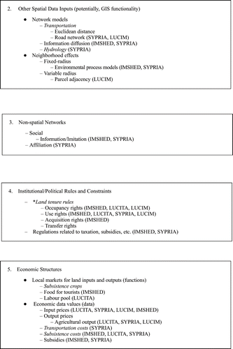
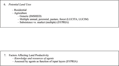
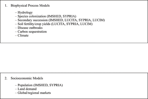
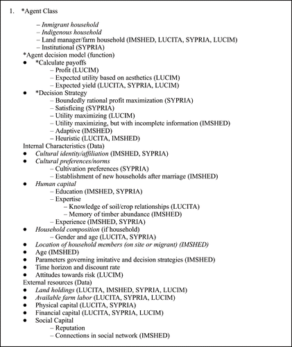
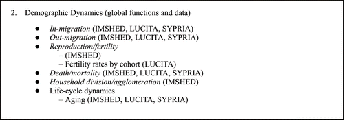
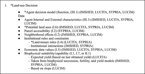
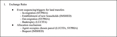
To what extent do the four models analysed here address the key questions put forth in section 2? We find, as expected, that some elements identified as important are modeled in a detailed fashion by all models, that some elements are uniquely covered by certain models, and that some elements are not modeled at all. Our analysis relies both on the model descriptions from section 3 and Figures in Appendix A.
A.1 Information/Data classes ().
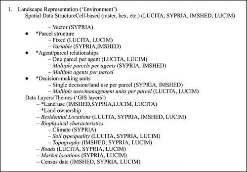
A.2 Interfaces to other models ().
A.3 Demographic classes ().
A.4 Land-use decision class ().
A.5 Land exchange class ().
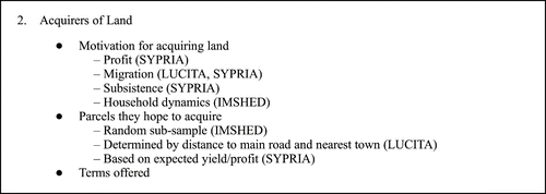
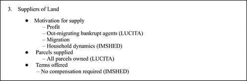
A.6 Interaction Environments ().
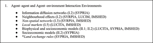
Spatial data structure and land exchange. No dynamic evolution of parcel boundaries occur in LUCITA (Altamira), IMSHED (Wolong), and LUCIM (Indiana), although land exploitation patterns evolve dynamically in IMSHED. SYPRIA (Yucatán) represents some parcel evolution, although transfers are institutionally constrained in the region. Although IMSHED, LUCITA, and SYPRIA each have fairly sophisticated models of household demographics (A.3.2), IMSHED alone represents the process of demographically driven household division and the subsequent spatial expansion of households. The relatively static nature of spatial boundaries in each model is reflected in the fact that none of the models implement land transfer rights (A.1.4), and the limited land-transfer mechanisms and exchange rules for the four models do not include the possibility of market transactions (A.5.1–A.5.3). This lack of focus on land tenure and land exchange, while it reflects the situation as it exists now or recently in particular individual sites, confirms the identification of this area as an important one for research (Parker and Berger Citation2002).
Given the potential importance of land exchange and its effects on land fragmentation or consolidation, this absence suggests that an interesting set of ‘what-if’ scenarios could be conducted for several of the study sites by implementing a broader set of land tenure rules and exchange mechanisms, and allowing agents to exchange land under these new rules. (Modified models could draw on prior and more recent examples of ABMs that implement land markets (Berger Citation2001; Happe, Kellermann, and Balmann Citation2006; Polhill et al. Citation2008). These models could be combined with vector-based parcel subdivision algorithms, such as those implemented by Alexandridis and Pijanowski (Citation2007).) The results may be particularly interesting for both the LUCITA and SYPRIA sites, as they are reaching a stage where more land market activity and land transfers are likely. Land consolidation has begun in earnest since 2000 in the LUCITA site, particularly near the city of Altamira and far from the TransAmazon on feeder roads. Near Altamira, one is likely to see well-capitalized properties dominated by cattle ranching, but also a continuation of the 100-ha properties producing intensive crops for the urban consumers. Some of these properties may become fragmented through sale and inheritance. Further away, less well-capitalized cattle ranches will predominate in areas with poor soils. Considering the context of complexity theory, land exchange and land-use successions due to intense human activities are likely mechanisms leading to instability and rapid shifts from one system state to another.
Non-spatial social networks. Both IMSHED and SYPRIA include non-spatial social networks, which significantly influence model outcomes. In IMSHED, the social network established through kinship relations helps the agents to ‘know’ who in the neighborhood they can and cannot marry, and thus influences decisions regarding when to marry and where to establish their households. Preliminary research in SYPRIA demonstrates the importance of kinship and neighborhood-based networks in transmitting cropping strategies, while cultural networks constrain and inform production choice. The social network representations in the agent-based models of land use reviewed here can be viewed as first steps towards a fully endogenous social network representation.
A more complete treatment of social networks would acknowledge that: (1) individuals and households are enmeshed in more than one potentially relevant set of social relations; (2) social network position and structure are relevant to multiple outcomes, including, but not limited to, land use; (3) social network position and structure are potentially endogenous, the consequence of other processes in the model. For instance, kinship and neighborhood-based networks may overlap to varying extents (Entwisle, Faust, Rindfuss, and Kaneda Citation2007), with consequences not only for land use directly through the sharing of information and (possibly) assistance, but also indirectly through consequences for related processes of migration, marriage, and household formation. Frontiers are particularly important strategic sites to study the importance of social networks for land use and other processes. While social networks are always dynamic, frontiers are characterized by higher than normal levels of change in networks due to the confluence of indigenous residents and in-migrants from multiple origins. Indeed, some effects of the region of origin or ethnicity that we currently see in models might actually be social network effects. Agents with similar characteristics (e.g. represented by cultural identity in SYPRIA) may act similarly not because of culturally defined preferences or measured characteristics, but because of diffusions of innovation within a social network.
Land suitability and resulting potential land uses. Consistent with Parker and Berger's (Citation2002) finding that ABM/LUCC models have successfully implemented socioeconomic/biophysical linkages, all of the models closely link biophysical suitability to land use (A.2.1). In fact, they demonstrate application of a range of biophysical process models, from endogenous soil fertility, to vegetative succession models, to invasive species spread. The endogenous suitability models have facilitated demonstration of a series of results with the models, including how temporal lags and path-dependence of land uses can lead to parcel life-cycles (LUCITA, SYPRIA) and how heterogeneous topography can attract a heterogeneous agent population (LUCIM). The biophysical process models embedded in LUCIM also suggest a future transition for the region. LUCIM indicates that the rate of reforestation is slowing, suggesting that much of the area that is marginal for agricultural production has already transitioned from agriculture to forest. This process suggests there may be an artificial limit to potential reforestation given a particular social and economic context. The reduced rate of reforestation in coordination with the looming process of exurbanization may result in the cessation of forest recovery and possibly a transition to forest cover decline in the study area, particularly as high-density residential development becomes more prevalent.
Land-use knowledge, cultural preferences, and capital of indigenous vs. in-migrant land users. SYPRIA is the only one of the four models to focus directly on interactions between indigenous and in-migrant land users, allowing direct exploration of the process through which a new land use can percolate through the social and physical landscape. However (again consistent with areas of success to date found by Parker and Berger (Citation2002)), all four models implement agents who are heterogeneous in multiple dimensions (A.3.1). LUCIM implicitly represents differences between the first wave of migrants, who rely more on profits from use of the land for household income, and the second migrant wave, which places a higher value on aesthetics. Both IMSHED and SYPRIA also represent cultural identity and cultural norms (A.3.1), thereby providing a mechanism for differentiating in-migrant populations. In a separate work, Manson and Evans (Citation2007) find that agent heterogeneity plays a key role in both the deforesting (SYRPIA/Yucatán) and reforesting (LUCIM/Indiana) study sites.
Economic and institutional drivers. All four models examine effects of prices (input, output, or both) on land-use decisions. Three of the four also include subsistence costs, and two include subsidies. Two local markets are represented – labor and food for tourists – although they do not model an endogenous price for the locally marketed good. In spite of the importance of local markets for subsistence crops that was identified, none were in the models. Especially for the LUCITA and SYPRIA study sites, it may be worth revisiting whether exclusion of this market could be biasing model results. In LUCITA, the credit programs that have been run at different times by the Brazilian government are an important economic driver that needs to be addressed. Both IMSHED and SYPRIA model incentives created through exogenous institutions, and SYPRIA uniquely tackles the challenge of modeling institutions as independent actors who interact with household agents.
Some of the most interesting and policy-relevant results from these modeling efforts come from the model experiments. These experiments allow us to see what would have happened had certain model inputs differed, and to look into the future and ask what will happen if we introduce certain policies. The particular strength of the modeling approach is that it allows us to get beyond findings that merely replicate (using a new method) already known patterns to understand implications for other parts of the coupled human–environment system. For example, while any demographer could tell you that a decline in fertility has a lagged suppression effect on population growth, the IMSHED model allows us to show the timing of its effect on panda habitat area relative to the timing of the effects of electricity subsidies or out-migration of various age groups. LUCITA demonstrates how the existence of an active labor market mediates effects of household demography on land clearing trajectories. Similarly, the LUCIM model goes beyond showing that forest regrowth is most common on steep slopes to show how that interacts with the in-migration of residents who gain aesthetic utility from forests.
Beyond these findings from individual models, the results suggest important experiments to be conducted using these four models. Experiments using both IMSHED and LUCITA show the importance of changes in age structure – IMSHED through differences in the age structure of out-migration and LUCITA through the age structure of in-migrants in different cohorts. LUCIM and SYPRIA could conduct similar experiments to examine changes in the age structure of relevant groups – out-migrants from the SYPRIA site and in-migrants in the LUCIM site. The results would show land use patterns likely to result from policies, such as government funding and policy on schooling in Mexico and inheritance and health care provision in Indiana. Similarly, results on the importance of mechanization of agriculture and land tenure from experiments in SYPRIA could provide lessons for using LUCITA to predict the effects of government support for mechanized agriculture or enforcement of land tenure laws in Brazil.
These and other ideas for the improvement of existing models are the product of our ‘retrospective’ approach to comparative modeling. The effort reported here was manageable with essentially no budget because team members had already developed multi-agent models for the sites where they had been working, using data from those sites that had been gathered as part of projects funded earlier. Because these models were designed and implemented independently by different research teams, they have relatively little in common in the foci of experiments and elements included. This opportunistic approach allowed us to carefully examine the challenge of cross-site generalization, which will be an important component of moving the land-use science community forward. We found the effort to be fruitful for the future development of each model, with results from one model suggesting future directions for other models. Yet, we found at many junctures that it would have been helpful to rebuild some of these models and to collect additional data for the sites to aid comparability, as well as run the different models on data for each of the sites to gauge the implications of differences in models, sites, and data availability. The next step, therefore, is to take the included elements in these models, as well as the elements excluded from all of them, and develop a prospective comparative modeling project in which completely comparable models are implemented across sites. We turn now to a first set of recommendations for how to develop such models, not necessarily requiring implementation by a single research team.
4.2. The way forward
Comparison of outcomes across models is hindered by the fact that by comparing models across sites, we are essentially assuming that model behavior would not change outside the range of the data used for model parameterization. In the future, if each model appears as a special case of a common, generalized agent-based simulation model within a single code base, this generalized model should let us explore the extent to which the conclusions drawn herein depend on the current empirically established model parameters, to explore the implications of error and uncertainty in data used for model creation, and to further explore thresholds that we expect to appear outside current parameter values. A code-instantiated generalized agent-based model will thus create a global parameter space that can be more fully explored via computational experiments. It is our belief that the land-use science community can work toward such a model through the collection of a core set of comparable data and the implementation of models with common elements by disparate research teams, but we are not so naïve that we think that this effort will emerge easily or spontaneously. However, the drivers and processes outlined in Section 2 can provide a guide for design of data collection protocols.
One obvious, but nonetheless significant, lesson is the importance of conceptualizing a model at a high level of complexity during the design stage to allow the research team to think about what is possible and what is necessary in terms of data collection. The frontier version of the MR POTATOHEAD meta-model presented here can be used as a starting point for discussions to identify critical sub-models and processes. Model complexity then can be stripped down as development, testing, verification, and validation progress. For example, if knowledge of the study area shows that changes in parcel boundaries are one of the most important correlates of land-use change, and the research team wants eventually to model these as endogenous, this suggests the need to collect substantially more boundary change data than would otherwise be necessary. Instead of working only from administrative records showing property boundaries and owners, the research team would develop a theoretical model of land transfers and collect relevant data on all actors (e.g. realtors or brokers). Some data cannot be collected retrospectively, especially data on social networks, additional actors, motivations, etc. Some data are not available for a given study area without prohibitive expense. Therefore, the highest level of complexity should be anticipated in the design of the study to ensure that adequate data are available and collected, allowing eventual production of the best model of the focal processes.
Several of us are now in the initial stages of developing multi-agent models in Amazonian Ecuador, northeastern Thailand, and the China-Laos border area, and we can use these case studies as examples of how we might implement the lessons of our comparative analysis. Spatial structure and interactions among agents vary across sites. In Amazonian Ecuador, ongoing efforts face some of the same issues as seen in LUCITA (Walsh, Messina, Mena, and Malanson, Citation2008), and spatial patterns there can be better simulated if the piano-key shapes of farms are imposed as an exogenous constraint. Since multiple land uses appear within a single parcel, the spatial data structure modeled in LUCITA (multiple decision-making units per parcel, A.1.1) could be followed also for a model of Ecuador, with the exogenous constraint on parcel location, size, and shape as a new aspect of spatial data structure not yet detailed in the MR POTATOHEAD model. In northeastern Thailand, parcels are often clearly delineated fields, but many households own a number of non-contiguous parcels, meaning that a ‘multiple parcels per agent’ spatial data structure (as used by IMSHED and SYPRIA, A.1.1) is appropriate.
Non-spatial social networks are likely to be important in the Thailand case in the context of rural-urban migration and the influence of remittances on land use. For the Thai site, there is a complete enumeration of all of the households in many villages and their social interconnections (Entwisle, Malanson, Rindfuss, and Walsh, Citation2008). These social ties affect, and in turn are affected by, all of the demographic outcome variables. We believe that such networks, primarily those extending out of the study area, are important in Amazonian Ecuador in determining where in-migrants will settle in relation to market centers (i.e. near people from the migration origin) and thus affect community development, which in turn affects land use (Pan and Bilsborrow Citation2005). Additional efforts to model rubber adoption across the Yunnan border into Laos are guided by efforts to include cultural heterogeneity and knowledge bases as village or household characteristics, reflecting village and household membership in certain networks.
Land suitability constrains land-use choices everywhere. For example, initial attempts to model forest conversion to rubber plantations in southern Yunnan, China, have been aided by delimiting the slopes and elevations that experience freezing temperatures. A remaining challenge is to endogenize changes in suitability as a result of land use in ABM (Yadav and Malanson Citation2008). The endogenous soil fertility and vegetation models used for the four case studies (A.2.1) can serve as models to follow. An important question arises as to whether changes in land use that are really constrained by suitability are only likely in the border areas among uses, analogous to ecotones.
Model comparisons indicate that inclusion of land markets may be a priority. In the northeastern Thailand study site, land markets may develop rapidly, and a land-market model could be used to explore their potential effects. An important point is that the land markets themselves develop at different stages of frontier development – the Northeastern Thai frontier has been closed for 30 years, while Altamira was only opened for settlement less than 40 years ago. This suggests that the current Thai experience could hold lessons for the future of Altimira.
Finally, the lessons about market forces are also instructive. The Thailand, Ecuador, and Yunnan/Laos projects all recognize changing global markets as exogenous forces. Direct linkages within the model have been discussed and included in statistical analyses (Messina and Walsh Citation2005) by the Ecuador team, whereas the other two treat markets as boundary conditions subject to manipulation in scenario generation. Particular challenges arise from modeling the effects of market forces, such as modeling lag times for different crops (e.g. how long do coffee prices have to be down in order for farmers to convert from coffee to another land use), modeling a diffusion process of information through social networks and institutions, and endogenizing prices in local markets. Although these processes are not included in the ABM/LUCC models examined here, they are in other ABM/LUCC models (Berger Citation2001; Polhill et al. Citation2008).
5. Conclusion
Detailed studies of particular sites have contributed much to the development of land-use science, especially when undertaken from multiple disciplinary perspectives. However, further progress requires us to move beyond the specifics of these sites to focus on a set of unifying questions and to develop theory, data, and analytic tools that can be broadly applied and tested. This paper has taken important steps in that direction through a structured comparison of four agent-based models that collectively cover many of the processes identified as key to land-use change in frontier regions. Particular attention was given to processes of in-migration, interaction of heterogeneous agent types, market integration, and land fragmentation vs. land consolidation. The models were described and compared in terms of spatial data structure, non-spatial social networks, land suitability and land uses, indigenous vs. in-migrant land users, land exchange, and economic and institutional drivers. Analysis of experiments conducted with these four models demonstrates how these components interact to shape land-use change in each region. In spite of the successes identified in the current models, we also identified areas where more work is needed. There are specific gaps with respect to the dynamic evolution of parcel boundaries through land exchange and the incorporation of interacting heterogeneous agents within as well as outside sites. In general, the importance of more accurately identifying, separating, specifying, and interconnecting endogenous drivers and responses to exogenous forces, especially during the period for which the models are developed and validated, comes out of these cross-site comparisons, where change is the only constant.
Acknowledgments
The development of this article was supported in part by a National Institutes of Health (NIH) Roadmap Initiative grant (HD051645) to the Carolina Population Center (CPC), University of North Carolina at Chapel Hill, and by NSF grant BCS-0527471. We are also grateful to the Carolina Population Center and the East–West Center for hosting workshops that facilitated the conceptualization of this paper. The research reported on was supported by a variety of grants, including NIH grant HD35811; NSF grant SES-0119572; NIH grant HD051776; NSF grants SBR9521918, SES0083511, and BCS062417; NSF CAREER Award and Biocomplexity Grants to J. Liu; National Institute of Child Health and Human Development R01 HD39789; Michigan State University; San Diego State University; the National Aeronautics and Space Administration New Investigator Program in Earth-Sun System Science (NNX06AE85G), the University of Minnesota's College of Liberal Arts and the McKnight Land-Grant Professorship Program; the NASA-LCLUC program (NAG5-6046, NAG5-11134, and NNG06GD98G) the Center for Integrated Studies of the Human Dimensions of Global Environmental Change, Carnegie Mellon University (NSF SBR 95-21914); NSF-Biocomplexity (BCS-0410016); and the George Mason University presidential fellowship. Contributions to the LUCIM model by Hugh Kelley, Royal Veterinary and Agricultural University (KVL), Food and Resource Economics Institute, Denmark, are gratefully acknowledged. Thanks to Barbara Harrison for excellent technical editing.
Related Research Data
References
- Aldrich , S. P. , Walker , R. T. , Arima , E. Y. , Caldas , M. M. , Browder , J. O. and Perz , S. 2006 . Land Cover and Land-Use Change in the Brazilian Amazon: Smallholders, Ranchers, and Frontier Stratification . Economic Geography , 82 : 265 – 288 .
- Alexandridis , K. and Pijanowski , B. C. 2007 . Assessing Multiagent Parcelization Performance in the MABEL Simulation Model Using Monte Carlo Replication Experiments . Environment and Planning B , 34 : 223 – 244 .
- An , L. , He , G. , Liang , Z. and Liu , J. 2006 . Impacts of Demographic and Socioeconomic Factors on Spatio-Temporal Dynamics of Panda Habitats . Biodiversity and Conservation , 15 : 2343 – 2363 .
- An , L. , Linderman , M. A. , Shortridge , A. , Ql , J. and Liu , J. 2005 . Exploring Complexity in a Human-Environment System: An Agent-Based Spatial Model for Multidisciplinary and Multi-Scale Intergration . Annals of Association of American Geographers , 95 : 54 – 79 .
- An , L. , Liu , J. , Ouyang , Z. , Linderman , M. , Zhou , S. and Zhang , H. 2001 . Simulating Demographics and Socioeconomic Process on Household Level and Their Impacts on Giant Panda Habitats . Ecological Modelling , 140 : 31 – 49 .
- An , L. , Lupi , F. , Liu , J. , Linderman , M. and Huang , J. 2002 . Modeling the Choice to Switch From Fuelwood to Electricity: Implications for Giant Panda Habitat Conservation . Ecological Economics , 42 : 445 – 457 .
- Angelsen, A., and Kaimowitz, D. (1999), “Rethinking the Causes of Tropical Deforestation: Lessons From Economics Models,” The World Bank Research Observer, 14, 73–98. Available online at http://www.worldbank.org/research/journals/wbro/obsfeb99/pdf/article4.pdf-list.
- Axelrod , R. and Cohen , M. D. 1999 . Harnessing Complexity: Organizational Implications of a Scientific Frontier , New York : The Free Press .
- Berger , T. 2001 . Agent-Based Spatial Models Applied to Agriculture: a Simulation Tool for Technology Diffusion, Resource Use Changes, and Policy Analysis . Agricultural Economics , 25 : 245 – 260 .
- Brondizio , E. , Mccracken , S. D. , Moran , E. F. , Siqueira , A. D. , Nelson , D. R. and Rodriguez-Pedraza , C. 2002 . “ The Colonist Footprint: Toward a Conceptual Framework of Land Use and Deforestation Trajectories Among Small Farmers in the Amazonian Frontier ” . In Deforestation and Land use in the Amazon , Edited by: OD , C. H. WO and RO , R. POR . 133 – 161 . Gainesville, FL : University Press of Florida .
- Brown , D. G. , Page , S. E. , Riolo , R. , Zellner , M. and Rand , W. 2005 . Path Dependence and the Validation of Agent-Based Spatial Models of Land Use . International Journal of Geographic Information Systems , 19 : 153 – 174 .
- Brown , L. A. , Sierra , R. , Digiacinto , S. and Smith , R. W. 1994 . Urban-System Evolution in Frontier Settings . Geographical Review , 84 : 249 – 265 .
- Casetti , E. and Gauthier , H. L. 1977 . A Formalization and Test of the ‘Hollow Frontier’ Hypothesis . Economic Geography , 53 : 70 – 78 .
- Chayanov , V. A. 1966 . The Theory of Peasant Economy , Homewood, IL : R. D. Irwin .
- Crawford , T. W. 2005 . Spatial Fluctuations as Signatures of Self-Organization: a Complex Systems Approach to Landscape Dynamics in Rondonia, Brazil . Environment and Planning B , 32 : 857 – 875 .
- D'antona , A. D.O. and Vanwey , L. K. 2007 . “Rural Urbanization in Santarem, Brazil: Factors Endogenous to the Region and Rural Households,” , Bloomington : Center for the Study of Institutions, Population and Environmental Change (CIPEC), Indiana University . CIPEC Working Paper CWP-07-02,
- Deadman , P. , Robinson , D. , Moran , E. and Brondizio , E. 2004 . Effects of Colonist Household Structure on Land-Use Change in the Amazon Rainforest: An Agent-Based Simulation Approach . Environment and Planning B , 31 : 693 – 709 .
- Deadman , P. J. . Paper Presented at the MODSIM 05 . December 12–15 2005 , Melbourne, Australia. “Household Decision Making and Patterns of Land Use Change in LUCITA: An Agent Based Simulation of the Altamira Region, Brazil,” ,
- Entwisle , B. , Faust , K. , Rindfuss , R. R. and Kaneda , T. 2007 . Networks and Contexts: Variation in the Structure of Social Ties . American Journal of Sociology , 112 : 1495 – 1533 .
- Entwisle , B. , Malanson , G. P. , Rindfuss , R. R. and Walsh , S. J. 2008 . An Agent-Based Model of Household Dynamics and Land Use Change . Journal of Land use Science. ,
- Entwisle , B. and Stern , P. C. 2005 . Population, Land use, and Environment: Research Directions , Washington, DC : National Academy Press .
- Entwisle , B. , Walsh , S. J. , Rindfuss , R. R. and Vanwey , L. 2005 . Population and Upland Crop Production in Nang Rong, Thailand . Population and Environment , 26 : 449 – 470 .
- Evans , T. P. and Kelley , H. 2004 . Multi-Scale Analysis of a Household Level Agent-Based Model of Landcover Change . Journal of Environmental Management , 72 : 57 – 72 .
- Evans , T. P. and Kelley , H. 2008 . The Influence of Landowner and Topographic Heterogeneity on the Pattern of Land Cover Change in South-Central Indiana . Geoforum. ,
- Evans , T. P. , Sun , W. and Kelley , H. 2006 . Spatially Explicit Experiments for the Exploration of Land Use Decision-Making Dynamics . International Journal of Geographic Information, Science , 20 : 1013 – 1037 .
- Foley , J. , Defries , R. , Asner , G. , Barford , C. , Bonan , G. , Carpenter , S. , Chapin , F. , Coe , M. , Daily , G. , Gibbs , H. , Helkowski , J. , Holloway , T. , Howard , E. , Kucharik , C. , Monfreda , C. , Patz , J. , Prentice , C. , Ramankutty , N. and Snyder , P. 2005 . Global Consequences of Land Use . Science , 309 : 570 – 574 .
- Geist , H. and Lambin , E. F. 2001 . What Drives Tropical Deforestation: A Meta-Analysis of Proximate and Underlying Causes of Deforestation Based on Subnational Case Study Evidence, Louvain-La-Nueve , Belgium : LUCC International Project Office Publication .
- Geist, H., and Lambin, E.F. (2002), “Proximate Causes and Underlying Driving Forces of Tropical Deforestation,” Bioscience, 52, pp. 143–150. Available online at http://www.geo.ucl.ac.be/LUCC/pdf/02_February_Article_Geist_.pdf.
- Goody , E. J. , ed. 1958 . The Developmental Cycle of Domestic Groups , Cambridge : Cambridge University Press .
- Gutman , G. , Janetos , A. C. , Justice , C. O. , Moran , E. F. , Mustard , J. F. , Rindfuss , R. R. , Skole , D. , Turner Ii , L. B. and Cochrane , M. A. 2004 . Land Change Science: Observing, Monitoring and Understanding Trajectories of Change on the Earth's Surface , Dordrecht : Kluwer Academic Publishers .
- Happe, K., Kellermann, K., and Balmann, A. (2006), “Agent-based Analysis of Agricultural Policies: An Illustration of the Agricultural Policy Simulator AgriPoliS, its Adaptation and Behavior,” Ecology and Society, 11, 49. Available online at http://www.ecologyandsociety.org/volII/issl/art49.
- Jepson , W. 2006 . Producing a Modern Agricultural Frontier: Firms and Cooperatives in Eastern Mato Grosso, Brazil . Economic Geography , 82 : 289 – 316 .
- Koontz , T. M. 2001 . Money Talks – but to Whom? Financial vs. Non-Monetary Motivations in Land Use Decisions . Society and Natural Resources , 14 : 51 – 65 .
- Lambin , E. and Geist , H. J. 2006 . Land-use and Land-cover Change: Local Processes and Global Impacts , Berlin : Springer .
- Lambin , E. F. , Turner , B. L. , Geist , H. J. , Agbola , S. B. , Angelsen , A. , Bruce , J. W. , Coomes , O. T. , Dirzo , R. , Fischer , G. , Folke , C. , George , P. S. , Homewood , K. , Imbernon , J. , Leemans , R. , Li , X. , Moran , E. F. , Mortimore , M. , Ramakrishnan , P. S. , Richards , J. F. , SkÅNes , H. , Steffen , W. , Stone , G. D. , Svedin , U. , Veldkamp , T. A. , Vogel , C. and Xu , J. 2001 . The Causes of Land-Use and Land-Cover Change: Moving Beyond the Myths . Global Environmental Change , 11 : 261 – 269 .
- Lim , K. , Deadman , P. , Moran , E. , Brondizio , E. and Mccracken , S. 2002 . “ Agent-Based Simulations of Household Decision Making and Land Use Change Near Altamira, Brazil ” . In Integrating Geographic Information Systems and Agent-based Modeling Techniques for Understanding Social and Ecological Processes , Edited by: Gimblett , H. R. 277 – 310 . Oxford : Oxford university Press .
- Linderman , M. , Liu , J. , Qi , J. , An , L. , Ouyang , Z. , Yang , J. and Tan , Y. 2004 . Using Artificial Neural Networks to Map the Spatial Distribution of Understory Bamboo from Remote Sensing Data . International Journal of Remote Sensing , 25 : 1685 – 1700 .
- Linderman , M. A. , An , L. , Bearer , S. , He , G. M. , Ouyang , Z. and Liu , J. G. 2006 . Interactive Effects of Natural and Human Disturbances on Vegetation Dynamics Across Landscapes . Ecological Applications , 16 : 452 – 463 .
- Liu , J. , Linderman , M. , Ouyang , Z. , An , L. , Yang , J. and Zhang , H. 2001 . Ecological Degradation in Protected Areas: The Case of Wolong Nature Reserve for Giant Pandas . Science , 292 : 98 – 101 .
- Livingstone , D. N. and Harrison , R. T. 1981 . Meaning Through Metaphor: Analogy as Epistemology . Annals of the Association of American Geographers , 71 : 95 – 107 .
- Malanson , G. P. , Zeng , Y. and Walsh , S. J. 2006a . Landscape Frontiers, Geography Frontiers: Lessons to Be Learned . Professional Geographer , 58 : 383 – 396 .
- Malanson , G. P. , Zeng , Y. and Walsh , J. S. 2006b . Complexity at Advancing Ecotones and Frontiers . Environment & Planning A , 38 : 619 – 632 .
- Manson , S. 2001 . Simplifying Complexity: A Review of Complexity Theory . Geoforum , 32 : 405 – 414 .
- Manson, S.M. (2000), ‘Agent-based Dynamic Spatial Simulation of Land-use/cover Change in the Yucatán Peninsula, Mexico,’ in: Fourth International Conference on Integrating GIS and Environmental Modeling (GIS/EM4), 2–8 September, 2000, Banff, Alberta, ( http://www.colorado.edu/research/cires/banff/pubpapers/81/ ).
- Manson , S. M. 2003 . “ Validation and Verification of Multi-Agent Models for Ecosystem Management ” . In Complexity and Ecosystem Management: The Theory and Practice of Multi-agent Approaches , Edited by: Janssen , M. 63 – 74 . Northampton, MA : Edward Elgar Publishers .
- Manson , S. M. 2004 . “ The SYPR Integrative Assessment Model: Complexity in Development ” . In Integrated Land-change Science and Tropical Deforestation in the Southern Yucatán: Final Frontiers , Edited by: Turner , B. L. II , Foster , D. and Geoghegan , J. 271 – 291 . Oxford : Clarendon Press .
- Manson , S. M. 2005 . Agent-Based Modeling and Genetic Programming for Modeling Land Change in the Southern Yucatán Peninsular Region of Mexico . Agriculture, Ecosystems & Environment , 111 : 47 – 62 .
- Manson , S. M. 2006a . Land Use in the Southern Yucatán Peninsular Region of Mexico: Scenarios of Population and Intitutional Change . Computers, Environment, and Urban Systems , 30 : 230 – 253 .
- Manson , S. M. 2006b . Bounded Rationality in Agent-Based Models: Experiments with Evolutionary Programs . International Journal of Geographic Information Science , 20 : 991 – 1012 .
- Manson , S. M. and Evans , T. P. . “Agent-Based Modeling of Deforestation in Southern Yucatán, Mexico, and Reforestation in the Midwest United States,” in . Proceedings of the National Academy of Sciences of the United States of America . Vol. 104 , pp. 20678 – 20683 .
- Manson , S. M. and O'sullivan , D. 2006 . Complexity Theory in the Study of Space and Place . Environment and Planning A , 38 : 677
- Mather , S. A. 1992 . The Forest Transition,” . Area , 24 : 367 – 379 .
- Mather , S. A. and Needle , L. C. 1998 . The Forest Transition: A Theoretical Basis,” . Area , 30 : 117 – 124 .
- McConnell , W. J. and Keys , E. 2005 . “ Meta-Analysis of Agriculture Change ” . In Seeing the Forest and the Trees: Human-environment Interactions in Forest Ecosystems , Edited by: AN , E. MOR and OM , E. OSTR . 325 – 353 . Cambridge, MA : MIT Press .
- McCracken , S. D. , Brondizio , E. S. , Moran , E. F. , Siquiera , A. D. , Nelson , D. and Rodriguez-Pedraza , C. 1999 . Remote Sensing and GIS at Farm Property Level – Demography and Deforestation in the Brazilian Amazon . Photogrammetric Engineering & Remote Sensing , 65 : 1311 – 1320 .
- McCracken , S. D. , Siqueira , A. D. , Moran , E. F. and Brondizio , E. S. 2002 . “ Land-Use Patterns on an Agricultural Frontier in Brazil: Insights and Examples From a Demographic Perspective ” . In Land use and Deforestation in the Amazon , Edited by: Wood , C. H. and Porro , R. Gainesville, FL : University Press of Florida, pp. 162–192 .
- Messina , J. P. and Walsh , S. J. 2005 . Dynamic Spatial Simulation Modeling of the Population – Environment Matrix in the Ecuadorian Amazon . Environment and Planning B , 32 : 835 – 856 .
- Mikesell , M. W. 1960 . Comparative Studies in Frontier History . Annals of the Association of American Geographers , 50 : 62 – 74 .
- Moran , E. F. 1981 . Developing the Amazon , Bloomington, IN : Indiana University Press .
- Moran , E. F. , Brondizio , E. and Mccracken , S. D. 2002 . “ Trajectories of Land Use: Soils, Succession, and Crop Choice ” . In Land use and Deforestation in the Amazon , Edited by: Wood , C. H. and Porro , R. 193 – 217 . Gainesville, FL : University Press of Florida .
- Moran , E. F. , Brondizio , E. S. , Tucker , J. M. , Silva-Forsberg , M. C.D. , Mccracken , S. and Falesi , I. 2000 . Effects of Soil Fertility and Land Use on Forest Succession in Amazonia . Forest Ecology and Management , 139 : 93 – 108 .
- Olson , J. M. , Alagarswamy , G. , J , resenn , J , Campbell D. , A , Davis , J , Ge , M , Huebner , B , Lofgren , P , Lusch E. , N , Moore , C , Pijanowski B. , J , Qi , P , Thornton , N , Torbick and J , Wang . 2008 . Integrating Diverse Methods to Understand Climate-Land Interactions in East Africa . Geoforum , 39 : 898 – 911 .
- Pan , W. , Walsh , S. J. , Bilsborrow , R. E. , Frizzelle , B. , Erlien , C. and Baquero , F. 2004 . Farm-Level Models of Spatial Patterns of Land Use and Land Cover Dynamics in the Ecuadorian Amazon . Agriculture, Ecosystems and Environment , 101 : 117 – 134 .
- Pan , W. K.Y. and Bilsborrow , R. E. 2005 . The Use of a Multilevel Statistical Model to Analyze Factors Influencing Land Use: A Study of the Ecuadorian Amazon . Global and Planetary Change , 47 : 323 – 352 .
- Parker , D. , Brown , D. , Polhill , J. G. , Manson , S. M. and Deadman , P. 2008 . “ Illustrating a New ‘Conceptual Design Pattern’ for Agent-Based Models and Land Use via Five Case Studies: The MR POTATOHEAD Framework ” . In Agent-based Modellaling in Natural Resource Management , Edited by: Paredes , A. L. and Iglesias , C. H. Valladolid, , Spain : Pearson Education .
- Parker , D. , Hessl , A. and Davis , S. C. 2008 . Complexity, Land-Use Modeling, and the Human Dimension: Fundamental Challenges for Mapping Unknown Outcome Spaces . Geoforum , 39 : 789 – 804 .
- Parker, D.C. (1999), Landscape Outcomes in a Model of Edge-Effect Externalities: A Computational Economics Approach. Publication 99-07-051 E. (Santa Fe, NM: Santa Fe Institute.) http://www.santafe.edu/sfi/publications/Working-Papers/99-07-051.pdf
- Parker, D.C., and Berger, T. (2002), “Synthesis and Discussion,” in Meeting the Challenge of Complexity: Proceedings of the Special Workshop on Agent-based models of Land-usel Land-cover Change, eds. Comparing ABM-LUC in frontier regions 65 D.C. Parker, T. Berger, and S.M. Manson, Santa Barbara, CA: CIPEC/CSISS, pp. 87–96. http://www.csiss.org/maslucc/ABM-LUCC.htm.
- Parker , D. C. , Manson , S. M. , Janssen , M. A. , Hoffmann , M. J. and Deadman , P. 2003 . Multi-agent Systems for the Simulation of Land-use and Land-cover Change: A Review . Annals of the Association of American Geographers , : 314 – 337 . <Go to ISI>://000184143400004.
- Parker , M. , North , M. J. , Collier , N. T. , Howe , T. R. and Voss , J. R. . Agent-Based Meta-Models . Paper Presented at the Agent 2006 Conference on Social Agents: Results and Prospects, . September 21–23 2006 . pp. 69 – 82 . Chicago, IL : Argonne National Laboratory .
- Parker , W. N. 1991 . “ The True History of the Northern Farmer ” . In Europe, America, and the Wider World: Essays on the Economic History of Western Capitalism , Edited by: Parker , W. N. 161 – 179 . Cambridge : Cambridge University Press .
- Playskool (2006), “Mr. Potatohead toy Information,” http://www.hasbro.com/playskool/mrpotatohead/
- Polhill , J. G. , Parker , D. and Gotts , N. M. 2008 . “ Effects of Land Markets on Competition between Innovators and Imitators in Land Use: Results From FEARLUS-ELMM ” . In Social Simulation Technologies: Advances and New Discoveries , Edited by: Hernandez , C. , Troitzsch , K. and Edmonds , B. 81 – 97 . Hershey, PA : Information Science Reference .
- Ragin , C. C. 2000 . Fuzzy-set Social Science , Chicago, IL : University of Chicago Press .
- Rindfuss , R. F. , Entwisle , B. , Walsh , S. J. , Mena , C. F. , Erlien , C. M. and Gray , C. L. 2007 . Frontier Land Use Change: Synthesis, Challenges, and Next Steps . Annals of Association of American Geographers , 97 : 739 – 754 .
- Rindfuss , R. R. , Walsh , S. J. , Turner , B. L. , Fox , J. and Mishra , V. 2004 . Developing a Science of Land Change: Challenges and Methodological Issues . Proceedings of the National Academy of Sciences of the United States of America , 101 : 13,976 – 13,981 .
- Rudel , T. K. 2005 . Tropical Forests: Regional Paths of Destruction and Regeneration in the Late 20th Century , New York, NY : Columbia University Press .
- Schaller , G. B. , Hu , J. , Pan , W. and Zhu , J. 1985 . The Giant Pandas of Wolong , Chicago and London : The University of Chicago Press .
- Simmons , C. S. , Walker , R. T. , Arima , E. Y. , Aldrich , S. P. and Caldas , M. M. 2007 . The Amazon Land War in the South of Para . Annals of Association of American Geographers , 7 : 95 – 107 .
- Siqueira , A. D. , Mccracken , S. D. , Brondizio , E. and Moran , E. F. 2003 . “ Women and Work in a Brazilian Agricultural Frontier ” . In Gender at Work in Economic Life , Edited by: Clark , G. 243 – 267 . New York, NY : Altamira Press .
- Stanford Center for Biomedical Informatics Research (2007), “Protege OWL,” http://protege.stanford.edu.
- Sylvester , K. M. and Gutmann , M. P. 2008 . “ Dustbowl Legacies: Long Term Change and Resilience in the Shortgrass Steppe ” . In Agrarian Landscapes in Transition , Edited by: Redman , C. and Foster , D. New York : Oxford University Press .
- Torrens , P. M. 2007 . A Geographic Automata Model of Residential Mobility . Environment and Planning B , 34 : 200 – 222 .
- Turner, B.L.I., Skole, D., Sanderson, S., Fischer, G., Fresco, L., and Leemans, R. (1995), “Land-Use and Land-Cover Change: Science/Research Plan,” IGBP and HDP Publication IGBP Report No. 35, HDP Report No. 7 – Stockholm and Geneva ( http://www.geo.ucl.ac.be/LUCC/lucc.html ).
- Turner , F. J. 1920 . The Frontier in American History , New York : H. Holt .
- Vance , C. and Geoghegan , J. 2004 . Modeling the Determinants of Semi Subsistent and Commercial Land Uses in an Agricultural Frontier of Southern Mexico: a Switching Regression Approach . International Regional Science Review , 27 : 326 – 347 .
- VanLandingham , M. and Hirschman , C. 2001 . Population Pressure and Fertility in Pre-Transition Thailand . Population Studies , 55 : 233 – 248 .
- Vanwey , L. K. , Brondizio , E. , D'antona , Á. , Moran , E. and Siquiera , A. 1–6 August 2004 2004 . “ Household Life-cycle and Land Use in the Brazilian Amazon ” . In Ecological Society of America 1–6 August 2004 , Portland, OR
- Vanwey , L. K. and Cebulko , K. B. 2007 . Intergenerational Coresidence in Brazilian Amaz[otilde]nia . Journal of Marriage and Family , 69 : 1257 – 1270 .
- Vanwey , L. K. , D'antona , A. D.O. and Brondizio , E. 2007 . Household Demographic Change and Land Use/Land Cover Change in the Brazilian Amazon . Population and Environment , 28 : 163 – 185 .
- Walker , R. T. , Perz , S. , Caldas , M. and Silva , T. D. 2002 . Land Use and Land Cover Change in Forest Frontiers: The Role of Household Life Cycles . International Regional Science Review , 25 : 169 – 199 .
- Walsh , S. J. , Messina , J. P. , Mena , C. F. and Malanson , G. P. 2008 . Complexity Theory. Spatial Simulation Models, and Land Use Dynamics in the Northern Ecuadorian Amazon . Geoforum , 39 : 867 – 878 .
- Warren , K. , Franklin , C. and Streeter , C. L. 1998 . New Directions in Systems Theory: Chaos and Complexity . Social Work , 43 : 357 – 372 .
- Yadav , V. and Malanson , G. P. 2008 . Spatially Explicit Land Use Land Cover and Soil Organic Carbon Transformations in Southern Illinois . Agriculture, Ecosystems & Environment , 123 : 280 – 292 .
- Yang , Y. and Li , C. 1992 . Sichuan Forests , Beijing, Yunnan : China Forestry Press .
Appendix A: MR POTATOHEAD representation of four agent-based models of land-use change in frontier regions
Starred elements are required for any ABM/LUCC model; elements in italics are deemed essential for a comprehensive model of land-use change in frontier regions. Elements or choices that correspond to each of the four models are noted by model acronym. Names in parentheses and quotes are used in the Protégé/OWL representation of MR POTATOHEAD. Figure modified from Parker et al. (Citation2008).
A.1. Information/Data classes ().A.2. Interface to other models ().
A.3. Demographic classes ().
A.4. Land-use decision class ().
A.5. Land exchange class ().
A.6. Interaction Environments ().