Abstract
The transition from command to market-oriented economies drastically affected land ownership and land management in Eastern Europe and resulted in widespread cropland abandonment. To examine these phenomena, we analysed the causes of post-socialist cropland abandonment in Argeş County in southern Romania between 1990 and 2005. Based on Landsat-derived maps of cropland use and a suite of environmental and socioeconomic variables hypothesized to drive cropland abandonment, we estimated spatially explicit logistic regression models for two periods (1990–1995 and 1995–2005) and three elevation groups. Our results showed that isolated cropland patches were more likely to become abandoned than more homogenous cropland areas. Unfavorable topography was an important determinant of abandonment in the plain and, to a lesser extent, hilly areas, but not in the mountains where locations with adverse market access and higher farm fragmentation exhibited higher likelihoods of cropland abandonment.
1. Introduction
Land-use practices are the main reason for the conversion of natural ecosystems into human-dominated landscapes (Foley et al. Citation2005; Kareiva, Watts, McDonald, and Boucher Citation2007), particularly in the tropics where croplands continue to replace forests at high rates (Lepers et al. Citation2005; Hansen et al. Citation2008). However, in other areas of the world, land-cover trajectories have reversed when countries reach an industrialized stage, as well as when population size stabilizes (Mather and Needle Citation1998; Rudel et al. Citation2005). This often results in a twofold pattern of intensified cultivation in areas favourable for farming, and the abandonment of cultivation where farming conditions are marginal (Baldock, Beaufoy, Brouwer, and Godeschalk Citation1996; MacDonald et al. Citation2000; Strijker Citation2005).
Cropland abandonment has widespread effects on ecosystem services, for example, increased carbon sequestration when cropland reverts back to forests (Silver, Ostertag, and Lugo Citation2000), decreased soil erosion (Tasser, Mader, and Tappeiner Citation2003), or increased water quality (Hunsaker and Levine Citation1995). On the other hand, traditional cultural landscapes are increasingly lost where cropland is abandoned (Government Service for Land and Water Management Citation2005; Palang et al. Citation2006), which often results in the decline of biodiversity (Brouwer, Baldock, and La Chapelle Citation2001; Cremene et al. Citation2005). Yet despite these effects, the rates and spatial patterns, as well as the underlying causes of cropland abandonment, are largely unknown in many parts of the world.
Cropland abandonment is often triggered by broad-scale political or socioeconomic shocks (Yeloff and Van Geel Citation2007). Central and Eastern European countries have experienced drastic and rapid changes in their political and socioeconomic structures since the collapse of socialist regimes. The departure from command economies was accompanied by a restructuring of the respective farming sectors, as well as land reforms that triggered massive ownership transfers of both natural resources and capital assets (Mathijs and Swinnen Citation1998; Lerman, Csaki, and Feder Citation2004; Rozelle and Swinnen Citation2004). Rural population compositions have changed dramatically due to large internal and external migration movements, especially of younger population segments (Angelstam, Boresjo-Bronge, Mikusinski, Sporrong, and Wastfelt Citation2003; Palang et al. Citation2006; Müller and Munroe Citation2008). As a result, cropland abandonment became widespread in the post-socialist era in Eastern Europe and European Russia (Bicik, Jelecek, and Stepanek Citation2001; Ioffe, Nefedova, and Zaslavsky Citation2004).
Several studies have mapped the rates and spatial patterns of post-socialist cropland abandonment in Eastern Europe, for example, in Albania (Müller and Sikor Citation2006), Estonia (Peterson and Aunap Citation1998), Latvia (Nikodemus, Bell, Grine, and Liepins Citation2005), and the Carpathians (Kozak, Estreguil, and Troll Citation2007; Kuemmerle et al. Citation2008a). These studies showed marked variability in abandonment rates throughout the region. Unfortunately, most studies did not employ quantitative and spatially explicit modelling techniques to assess the underlying determinants of cropland abandonment (for an exception, see Müller and Munroe Citation2008, in Albania). Yet such methods are powerful tools for linking observed land-use changes to a suite of environmental and socioeconomic driving factors.
Overall, the determinants of post-socialist cropland abandonment remain largely unexplored. This is unfortunate, because post-socialist cropland abandonment in Eastern Europe offers unique opportunities to study the role of changing institutions and socioeconomics for land-use change. Indeed, cropland abandonment may continue to be the primary land-use change in many industrialized countries (Verburg, Schulp, Witte, and Veldkamp Citation2006). Understanding the determinants of post-socialist cropland abandonment may provide valuable management insights, inform policy-makers, and help to improve future land-use scenarios. Moreover, statistical modelling of land-use change facilitates the testing of theoretical assumptions and hypotheses (Munroe and Müller Citation2007).
Studying the determinants of cropland abandonment in Romania is interesting from several perspectives. For example, Romania is the second largest new member state of the European Union with the largest share of farmland (65%) among the new accession countries (FAO Citation2006). Romania followed a unique land reform strategy that combined restitution to former owners, or their heirs, with a redistribution of ownership rights to former cooperative workers who had contributed land to the cooperative. But land markets in Romania remained inactive until the late 1990s, with few reported sales and leases (Swinnen, Vranken, and Stanley Citation2006). This resulted in a farming structure characterized by a large share of small farms with little commercial activities (Dawidson Citation2005). In addition, the land reform also created a large class of absentee landowners who did not reside in rural areas, as well as many old landowners (Chirca and Tesliuc Citation1999; Mathijs and Noev Citation2004). Overall, the effect of the changing land property situation on the rate, extent, and spatial patterns of cropland abandonment is unclear.
In a previous study, we assessed post-socialist land-use change in Argeş County, southern Romania, based on Landsat Thematic Mapper and Enhanced Thematic Mapper Plus images from 1990 to 2005 (Kuemmerle, Müller, Griffiths, and Rusu Citation2009). Building upon this work, the focus here is on assessing the underlying causes of cropland abandonment, the largest post-socialist land use in Argeş County. To accomplish this, we linked cropland abandonment from two time periods (1990–1995 and 1995–2005) to a suite of bio- and geophysical, socioeconomic, and policy-related variables using spatially explicit logistic regressions models. Beforehand, we hypothesized that variables affecting agricultural suitability and farm profits, as well as rural population dynamics, were the prevailing factors that contributed to cropland abandonment in Argeş County. Specifically, our objectives were as follows:
-
To quantify the direction and strength of the causal influences of each variable on cropland abandonment during the two periods.
-
To compare the causal influence of the variables in the regression model for the entire study area with models estimated for three elevation subgroups.
2. The study area
We studied Argeş County in central Romania () because the region encompasses a wide range of environmental conditions. The county is part of the historical province Muntenia and covers an area of 6826 km2, has a mean annual rainfall of 750 mm and a mean annual temperature of 7°C. Predominant soil types are Argillic soils in the plains, Cambisols in the hilly areas, and Podzols in the mountainous areas. Biogeophysical variables show clear north–south patterns. For instance, elevation and rainfall are higher in the north, whereas temperature is lower.
Figure 1. Study area.
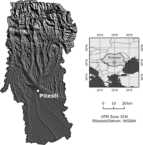
The southern region of Argeş County consists of a plain (<250 m above sea level), whereas the hilly zone (250–1500 m) contains the county's capital and major market center Piteşti (174,000 inhabitants in 2003 (NIS Citation2004), which is linked to the country's capital Bucharest by highway. Close to Piteşti is the main factory of the carmaker Dacia, the largest private employer in the region. The mountainous northern part of the study area (above 1500 m), a part of the Carpathian Mountains, is characterized by rugged terrain and includes Romania's highest mountain, the Moldoveanu Peak (2544 m).
3. Data and variables
3.1. Land-cover maps and dependent variables
Land-cover maps for the years 1990, 1995, and 2005 were available from a previous study (Kuemmerle et al. Citation2009). These maps were generated by classifying the land-cover types forest, cropland, and permanent grassland (including shrubland) from Landsat TM and ETM + images at a spatial resolution of 30 m × 30 m using a hybrid classification approach (Bauer et al. Citation1994; Kuemmerle, Radeloff, Perzanowski, and Hostert Citation2006). Settlements, roads, and water bodies were masked prior to classification based on available topographic maps. The accuracy of these land-cover maps was assessed based on a random sample of 765 ground truth points mapped in the field. Overall accuracy was 91.0% (Kappa = 0.86), 92.5% (0.89), and 91.0% (0.86) for 1990, 1995, and 2005, respectively. Land-cover changes were mapped via post-classification map comparison (Coppin, Jonckheere, Nackaerts, Muys, and Lambin Citation2004), which yielded two change maps for the periods of 1990–1995 and 1995–2005. A detailed description of the change analyses is provided in Kuemmerle et al. (Citation2009).
Cropland decreased strongly in Argeş County during transition, but within distinct spatial clusters (). In total, 21% of the cropland was abandoned in 1990, which equaled an area of 512 km2 and represented a decrease from 35 to 28% relative to the county's area. Cropland abandonment was more prevalent in the 1990–1995 period (17%, equaling 415 km2) compared to the 1995–2005 period (5%, 97 km2) (Kuemmerle et al. Citation2009).
Figure 2. Spatial patterns of cropland abandonment.
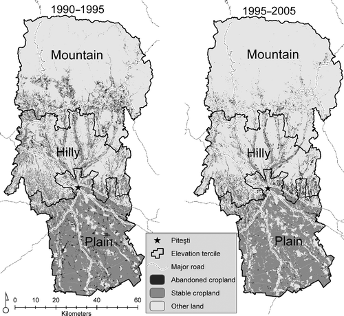
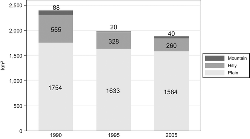
Patterns of abandonment varied considerably along altitudinal gradients (Kuemmerle et al. Citation2009). In 2005, cropland covered 70% of the land surface in the plains (1754 km2 of 6286 km2), 11% in the hilly areas, and a mere 2% in the mountains (). In the mountainous areas, cropland decreased from 88 to 40 km2 despite a slight increase between 1995 and 2005. In the hilly area, 227 km2 (41% of the 1990 cropland) were abandoned in the first and 68 km2 (21%) in the second period, respectively. In the plains, 170 km2 or 10% were abandoned and almost three-quarters of this decline took place between 1990 and 1995. In sum, Argeş experienced the highest amounts of cropland abandonment in the hilly zone and the highest rates in the mountainous north.
Figure 3. Cropland changes by elevation subgroup.
3.2. Cropland density
Land-use change at a particular location often depends on its surroundings. For example, the decision to abandon a cropland pixel may depend on the presence of nearby cropland. The inclusion of a spatially lagged average of the dependent variable as an additional regressor can account for this, but may lead to endogeneity in the lag variable, as well as potentially biased coefficients (Anselin Citation2002). To control for such endogeneity, we constructed a variable containing the number of neighbouring cropland pixels at the beginning of each change period within a three-by-three window. This approach is similar to Geoghegan, Waininger, and Bockstael (Citation1997) and Geoghegan et al. (Citation2001), who included patterns of surrounding land uses in their estimations to capture the diversity of land use. Gellrich, Baur, Koch, and Zimmermann (Citation2007) used a binary variable if surrounding observations were equal to their dependent variable. Our approach has the additional advantage that it partly controls for potential endogeneity between the dependent and the independent variables by including a temporal lag. Besides, the density variable is an ordinal measure that captures the homogeneity of cropland in the immediate surroundings.
3.3. Time-invariant location factors
We used the Shuttle Radar Topography Mission digital elevation model (DEM) with a spatial resolution of 90 m (Slater et al. Citation2006). The DEM was used in the classification process (Kuemmerle et al. Citation2009) and therefore not employed as a covariate. Instead, we calculated terrain roughness (the slope curvature), which is not correlated with elevation. Roughness values were multiplied by a factor of 10 to match the data range of the other variables.
The road network consisted of four different road categories: the highway linking Bucharest with Piteşti (category 1), European roads (2), national roads (3), and county roads (4). To assess the influence of road presence on cropland abandonment, three Euclidean distance measures were calculated cumulatively. First, using road categories 1 and 2; second, using road categories 1, 2, and 3; and, third, using all four road categories.
We also include a variable that captured the distance of each location to the northern limit of the study region (subsequently labeled ‘Y coordinate’) to control for spatial dependence in the model residuals (Tasser, Walde, Tappeiner, Teutsch, and Noggler Citation2007) and to account for the existing north–south gradient. No systematic patterns were observed in the east–west direction and we therefore did not include an X coordinate. We excluded temperature and soil data due to collinearity with the Y indicator variable.
3.4. Rural commune census
A census of all rural communes was carried out in Argeş during the summer and autumn of 2005. Covering socioeconomic and demographic developments, input use, farm fragmentation, and productivity parameters, the census captured exogenous influences, as well as endogenous changes within communes, that were hypothesized to be relevant for cropland abandonment. Municipalities and towns were excluded from the primary data collection because we focused on land use in rural areas. We used a structured questionnaire for group interviews with selected key informants such as commune mayors, agricultural and forestry agents, and cadastral officers. All 16 interviewers were trained in survey and interviewing techniques and carried out the interviews in groups of two. The interviewers were instructed to facilitate a discussion among the respondents to verify and check responses with all participants. Temporal coverage was achieved through recall techniques (Groves Citation1989) of landmark events that the respondents could easily remember and that approximately matched the date of the land-cover maps. The first year (1989) depicts the situation during socialism and 1996 was chosen as an intermediate point in time when the Romanian presidential election was held.
We calculated livestock units from the census data to assess the effect of livestock breeding on cropland use. We used the livestock unit coefficients for countries of the Organisation for Economic Co-operation and Development, OECD (Chilonda and Otte Citation2006). The cattle, sheep, and goat numbers were multiplied by 0.9, 0.1, and 0.1, respectively, and divided by the commune area to yield livestock unit densities as covariates for 1989 and 1996. We further used the number of tractors per commune to proxy agricultural input levels. Several other potentially interesting measures of input intensity (e.g., irrigated area, use of certified seeds, or the use of fertilizer) could not be included due to missing values or lack of variation across the communes. Land reform effects were captured by two variables: First, we used the average number of plots owned by respondents of a commune after land reform implementation. More plots are equivalent to a higher physical fragmentation of the farm, because plot locations are typically noncontiguous. Second, the share of cropland owned by individuals within each commune was calculated to obtain a measure for the type of agricultural production organization. Both variables were only included in the second period because they did not vary significantly in 1989.
3.5. Population and migration proxies
We used interpolation techniques to approximate a spatially continuous population distribution based on the village population data gathered in the rural commune census. This population surface served as a proxy for the demand for cropland at the pixel level. Villages with missing records for 1989 or 1996 (about 10% of the cases) were replaced with official census data from the National Institute of Statistics (NIS Citation2004). We disaggregated the commune-level population data from the NIS census data to village level by distributing the official data proportionally among the missing villages within a commune. We then calculated the centroids of the village boundaries, linked the population data to these points, and used a third-order inverse distance weighted interpolation to derive continuous population surfaces. Based on visual assessments of the density maps and field experience, we decided to include up to five nearest neighbours and a maximum interpolation distance of 5 km (representing the maximum sphere of spatial influence of inhabitants from a village). This yielded two population density maps, one each from 1989 and 1996. In addition, we included the household density per square kilometer in 1989 and 1996 as independent variables in the models.
Emigration was proxied by the number of individuals who left the commune permanently. The migration variable was the only variable that spanned the entire estimation period, because it was collected for the periods 1989–1996 and 1996–2004. To avoid endogeneity bias (see Section 5.2), we tested the robustness of the emigration variable by estimating the models with and without migration. Coefficients, signs of other variables, and model fit did not change, and we therefore decided to include this potentially important driver in our models. Lastly, temporary emigration in 1996 was included as a variable to capture the economic effect of remittance returns from seasonal migration on cropland abandonment. At the beginning of the 1990s, migration returns were close to zero in all communes and therefore temporary migration was not considered as a covariate in the first estimation period from 1990 to 1995.
3.6. Hypothesized influence of the covariates
In total, we considered 14 covariates that we a priori expected to influence cropland abandonment (). We assumed that undulating terrain (higher roughness) would increase cropland abandonment, as agricultural production may concentrate on locations that are better suited for market-oriented production (MacDonald et al. Citation2000; Ioffe et al. Citation2004). Similarly, we hypothesized higher abandonment at more marginal locations for the variables that proxy road access.
Table 1. Independent variables with hypothesized influence on cropland abandonment
Higher rural population density was assumed to have a negative bearing on land abandonment via the increased demand for cultivated land (Angelstam et al. Citation2003; Ioffe et al. Citation2004). We further expected a lower efficiency of resource consumption per capita in smaller households, as a result of the varying resource use intensity among households and individuals (Liu, Daily, Ehrlich, and Luck Citation2003). In Argeş County, household size decreased, whereas the number of households increased (own data). Thus, higher per capita consumption in smaller households may have stimulated abandonment, whereas higher household density may have increased cropland demand. Temporary and permanent emigration were unevenly distributed across age groups, with the young and economically active typically being the first to leave. Therefore, emigration possibly induced labour shortages, thereby increasing abandonment (Nikodemus et al. Citation2005; Müller and Munroe Citation2008).
More tractors per commune (a proxy for agricultural input intensity) potentially increased agricultural production, reflected a higher market orientation and was labour-saving, possibly reducing overall abandonment. On the other hand, labour scarcity due to selective migration could have induced farmers to abandon marginal plots and concentrate their capital and labour inputs on the best plots. Moreover, marginal plots may not be suitable for mechanization. Thus, the ultimate effect of tractor numbers on the amount of cropland used was a priori unclear. The effect of livestock density on cropland abandonment may also have been twofold: Intensive livestock rearing may stimulate fodder crop cultivation, thereby keeping abandonment rates low. On the other hand, extensive livestock production may amplify cropland abandonment due to converting cropland to pastures. Overall, the effect of livestock density on abandonment was unclear a priori, because we have no spatial data on the intensity of livestock production.
More plots owned by a household (the farm fragmentation proxy) presumably resulted in production inefficiencies via increased labour requirements and reduced the effectiveness of and the incentive for mechanization (van Dijk Citation2003), thereby fostering abandonment. Similarly, land owned by the state or by legal and family associations may have been more likely to be kept in cultivation due to higher input use and mechanization levels, as well as better access to financial capital.
4. Statistical approach
4.1. Data integration and sample selection
We combine the variables derived from the commune census with the spatially explicit data based on the commune boundaries by assigning the same value for all pixels within a commune. All calculations were conducted using a spatial resolution of 28.5 m to match the land-cover maps, resulting in 8,395,490 observations within Argeş County. All grids were converted to integer values to reduce computing time and the distance measures were rescaled to 100 m steps to facilitate the interpretation of the statistical results.
The final data set was the result of five sampling steps. First, an inside buffer of 1 km was erased from the boundary of the study area to avoid influences from neighbouring counties (Müller and Zeller Citation2002). This buffer size was based on visual inspection, but sensitivity tests with larger buffer sizes did not alter the results. Second, spatial coding was carried out to select non-adjacent pixels at a specified distance from the nearest selected neighbour to reduce spatial autocorrelation in the response variable (Besag Citation1974; Nelson and Hellerstein Citation1997). To choose an appropriate distance between selected observations, we tested different coding schemes ranging from distances of 6–15 pixels between selected neighbours, and decided to use a distance of 9 pixels (228 m) as a compromise between the correction of spatial dependency among observations and the rapidly decreasing number of observations. Third, only observations that were covered by cropland at the beginning of the respective change period were selected. In that way we accounted for the temporal dependence of cropland abandonment on the state of land cover at the start of the respective period (Tasser et al. Citation2007; Müller and Munroe Citation2008). This also ensured that abandoned pixels in the first period did not affect coefficients in the second period. Fourth, disproportionate (or balanced) sampling was applied to the binary-dependent variable, because the number of observations with stable cropland (= 0) was much larger than the number of abandoned pixels (= 1) – as is often the case in land-use/land-cover studies (Serneels and Lambin Citation2001; Gellrich et al. Citation2007). We randomly selected 1000 observations from both the presence and absence group. Such disproportionate sampling in logistic regression analysis does not affect the coefficients, but can affect the constant term and, therefore, the predicted probabilities (Maddala Citation2001). The constant has to be decreased by ln(p 1) − ln(p 0) to obtain correct predictions, where p 1 and p 0 are the proportions of the sampled observations from the presence and absence group, respectively, and ln is the natural logarithm.
The models were estimated for the entire study area (hereafter called the global model). Although such results can be highly relevant for policy-making, global models average out the spatial heterogeneity (Osborne and Suarez-Seoane Citation2002). This may be especially problematic for an ecologically diverse region such as Argeş County. We, therefore, calculated elevation terciles for the mean elevation within a commune to obtain three elevation subgroups that displayed high elevation homogeneity within a group, but strongly differed from each other. Three additional models (local models) were fitted for the elevation subgroups that are subsequently referred to as the plain model, hilly model, and mountain model for the low, the medium, and the high elevation terciles, respectively. Every subgroup contained 31 communes, but they differed in their spatial extent (and the number of pixels) due to varying commune sizes. We employed identical sampling strategies for the subgroups and randomly selected 500 abandoned and 500 non-abandoned observations.
4.2. Estimation strategy
To understand the causal determinants of cropland abandonment in Argeş County at the pixel and at the commune level, we fitted maximum likelihood-based binary logistic regressions. Two logistic regression models of cropland abandonment were estimated, one for the 1990–1995 period and one for the 1995–2005 period. Estimating two change periods allowed us to describe the temporal changes in the influences of the independent variables that affected the use of cropland. All time-variant variables were included using values from the beginning of the respective change period. We consider these temporally lagged variables as exogenous covariates of cropland abandonment, because the lags avoid the endogeneity bias which arises from a possible simultaneity of cropland abandonment and the covariates (Müller and Zeller Citation2002; Perz and Skole Citation2003). This assumes that later abandonment did not influence the state of a variable at the beginning of the respective period. This regression setup allows us to go beyond mere associations between variables and permits, in connection with field-based evidence, causal interpretations of the effects of the independent variables on cropland abandonment.
The multilevel data structure required corrections to ensure the independence of observations. Pixels within communes may exhibit dependence, whereas pixels across communes are more likely to be independent (Müller and Munroe Citation2005; Overmars and Verburg Citation2006; Gellrich et al. Citation2007). To control for these within-group effects, robust estimation techniques were employed that account for potential correlations within communes. We used a variant of the Huber and White estimator that affects the variance–covariance matrix by estimating robust standard errors, but leaves the estimated coefficients unaffected (Froot Citation1989; Gutierrez and Drukker Citation2005). Within-group adjustment also has the additional advantage of controlling for potential spatial autocorrelation in the residuals by accounting for correlations of observations within communes (Gellrich et al. Citation2007).
In total, eight models were estimated: one global and three local models for each of the two periods. The variance inflation factor (VIF) was used in all models to test for multicollinearity in the covariates. VIF assesses whether the variance of one explanatory variable is independent from all other explanatory variables (Chatterjee, Hadi, and Price Citation2000). The only variable that had to be deleted from the subgroup estimations (but not the global model) was the Y coordinate, which was positively and significantly correlated with terrain roughness. No serious multicollinearity was detected for all other variables with a mean VIF below 1.5 and the largest VIF below 10. Several ad hoc methods to correct for spatial effects were employed: the Y coordinate (Section 4.3) in the global regressions, the coding scheme (Section 5.1), and the roughness variable, which was included as a spatial average in a nine-by-nine rectangular window (Nelson, Harris, and Stone Citation2001).
The degree to which the statistical estimations explain the occurrence of land abandonment was assessed using five goodness-of-fit statistics: First, McFadden's adjusted R 2 (adj. R 2) was used to assess the regression fit. Adj. R 2 is a common measure in logistic regressions that accounts for the number of parameters included (Ben-Akiva and Lerman Citation1985). Second, the percentage of correctly predicted observations (PC) was calculated from the predicted probabilities by assuming the highest predicted probability as the predicted value. Third, the area under the curve (AUC) of the receiver operating characteristics (ROC) was estimated using a nonparametric ROC curve (Metz Citation1978). The AUC measures the share of the correctly predicted positive (abandoned) from all predicted positive values against the share of the correctly predicted negative (stable cropland) against all negative values. The AUC is derived by varying the probability threshold, which results in an AUC between 0.5 for a random map and 1.0 for a perfect prediction (Pontius and Schneider Citation2001). Fourth, the Kappa statistic quantifies the locational accuracy between predicted and observed data compared to a random map (Cohen Citation1960). A perfect prediction yields Kappa = 1 and Kappa approaches 0 if correct predictions are equal to those of a random map. Last, we calculated the Bayesian Information Criterion (BIC), which compares subgroup models by judging the distance between the fitted model and the observed data based on the log-likelihood function (Schwarz Citation1978). The more negative the BIC, the better the model fit.
5. Results
The regression results suggested that the determinants of cropland abandonment varied considerably for the elevation subgroups in significance and strengths of the influences. Globally, the density of cropland and topography were important determinants while market access and farm fragmentation emerged as driving factors of cropland abandonment in the hilly and mountainous areas.
5.1. Descriptive statistics of covariates
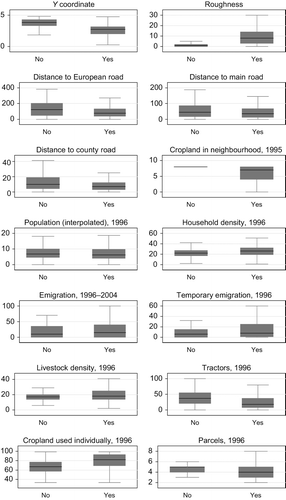
The concentration of cropland in neighboring locations at the beginning of the respective period showed the strongest relationship with cropland abandonment ( and ), suggesting that abandonment was more likely to occur where cropland was less homogenous. The extent of abandonment was higher further north (lower Y coordinate) and at locations with rougher terrain in the first and second period. In the second period, abandonment was associated with proximity to roads, which was indicated by lower medians and lower ranges of the road distance variables. Fewer tractors per commune in both periods and a larger share of individually owned cropland in the second period appeared to be connected with the occurrence of cropland abandonment. No clear relationship was found for the other independent variables.
Figure 4. Box plots of independent variables by cropland abandonment, 1990–1995.
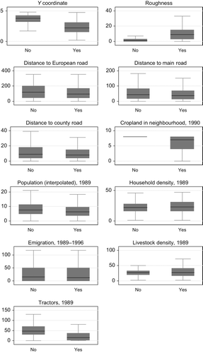
Figure 5. Box plots of independent variables by cropland abandonment, 1995–2005.
5.2. Determinants of cropland abandonment
Goodness-of-fit statistics for the eight logistic regression models are summarized in . The two global models displayed excellent fit with AUC of 0.84 (81% correct predictions) and 0.89 (79%) for the periods of 1990–1995 and 1995–2005, respectively. Kappa was good with 0.48 and 0.43. The model fit was somewhat lower for the three elevation subgroups, especially for the first period in the plain and mountainous areas. The models performed reasonably well for hilly areas in both periods and considerably better for the plains in the second period. Models for the mountainous areas showed lower goodness-of-fit in both periods with AUC of 0.7.
Table 2. Goodness-of-fit
To facilitate the readability of the results (in total, more than 100 coefficients plus associated statistics), we omitted the tables with coefficients, standard errors, and p-values.1 Instead, we chose a graphical description of the estimation results. visualizes the odds ratios, their 95% confidence intervals, and p-values in a compact form, with one graph for each independent variable. Each plot in contains the global and subgroup regressions for both periods to facilitate comparability of models. Coefficients with significance levels below 20% were omitted.
Figure 6. Odds ratios, p-values, and confidence intervals for the logistic regressions.
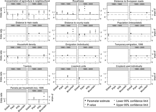
The concentration of cropland in neighbouring locations had the largest quantitative impact on the occurrence of abandonment. In the global model, one additional pixel of cropland in the immediate neighbourhood decreased the odds of abandonment by 19% (equivalent to an odds ratio of 0.81) in the first period and by 28% in the second period. Spatially homogenous cropland patterns were particularly important in the plains, where an additional cropland pixel in the neighbourhood decreased the likelihood of abandonment by 34% in both periods. In the hilly area, the decrease was about 17% in both periods, whereas in mountains the decrease in the odds ratio was considerably lower.
Terrain roughness had a significant influence on cropland abandonment in most models with the expected positive sign. While the effect was small in the mountainous subgroup during the first period and vanished in the second, terrain undulation was associated with increased abandonment in areas of low and medium elevation. The global model masked this elevation-specific effect.
The effects of distance to the European and main roads were insignificant or small in both periods. But pixels located farther away from county roads were more likely to become abandoned in the hilly and mountainous subgroup in both periods. This effect was largest in the mountains and between 1995 and 2005, when the probability of abandonment increased by 7% every 100 m further away from a local road. Road access did not substantially affect abandonment in the plains. At the county level, local variations of road influence averaged out.
Our models did not reveal strong quantitative evidence for a relationship of cropland abandonment with population and household density or migration. Higher population density counteracted cropland abandonment for the entire study area in the second period, but was insignificant for the elevation subgroups. Household density made abandonment less probable in the first period and more probable in the second. Permanent and temporary emigration had a small negative influence in the mountainous subgroup during the second period.
Globally, a higher density of livestock decreased the likelihood of abandonment in the second period. Again, the global results masked subgroup variations. For example, in the hilly areas a higher livestock density was associated with higher abandonment in both periods. Finally, higher farm fragmentation within a commune positively influenced the likelihood of cropland abandonment in the mountainous region, where the regression results suggest that the ownership of an additional parcel per farmer increased the odds of abandonment by 28%. Farm fragmentation had no measurable effect on cropland abandonment in the hilly and plain areas.
6. Discussion
The study region underwent drastic changes in livelihood strategies, which shaped land use and land cover during the post-socialist period. Cropland abandonment was widespread in Argeş County and most of this abandonment occurred at the onset of transition. Cropland became more stable between 1995 and 2005, but abandonment proceeded at high rates in some areas. Cropland abandonment differed notably by topographic conditions. The highest absolute decrease was observed in hilly areas, whereas the highest abandonment rate was found in the mountains. We identified topographic variables, the spatial homogeneity of cropland use, and accessibility as the most important determinants of this process. However, the influence of these drivers differed considerably among elevation subgroups in significance and strength of influence.
The logistic regression models for the entire county fitted the data very well. The explanatory power of the models for the elevation subgroups was lower, particularly in the mountainous areas in both periods and in the plains in the first period. Reasons for the lower fit were possibly the small variation of commune-level data in the subgroup models. In addition, only half as many observations entered the regressions in the subgroup models. Nevertheless, the subgroup results emphasized that great care is required when interpreting and inferring from the results of one regression model for a study region as large and diverse as Argeş. Global coefficients masked important subregional variations and only disaggregating the study area along a topographic gradient revealed remarkable local variations in the determinants of cropland abandonment.
For example, more isolated patches of cropland were more likely to become abandoned, but this effect was three times stronger in the plains compared to the hilly or mountainous subgroups in both periods. This result may in part reflect the patchiness of the agricultural landscape in the mountainous areas, where many of the small and isolated plots remained in cultivation, albeit at low cultivation intensities. Cropland in the plains had a larger tendency to become more homogenous over time. The higher commercial orientation of farmers and the higher share of legal and family associations in the plains may have contributed to this trend toward more consolidated land-use pattern in the plains.
Cultivation in the plain and hilly areas was significantly more likely on flat terrain, indicating the importance of topographic variation in agricultural production. In the mountains, terrain roughness had no discernible effects; rather, adverse road access and higher farm fragmentation contributed to cropland abandonment. Higher transportation costs may have reduced the profitability of farming to the point where farmers gave up cultivation on remote plots. Higher farm fragmentation negatively affected the change in cropland area in the mountainous areas. We assume that the higher fragmentation may have become a critical factor for cropland use for the low-intensity, semi-subsistence farming systems in the mountains, because it increased labour and management requirements. Higher input requirements may have induced farmers to stop cultivating on marginal plots.
Population and migration proxies were weaker predictors of cropland abandonment than expected. Several reasons may explain their small or insignificant influence. First, the insecure status of many emigrants may have prompted people to keep land in cultivation in order to reduce the risks involved in migration. In addition, land rentals are sometimes pursued on a yearly basis for a small return in cash or kind (own data). The effect of emigration on abandonment in the southern plains may have been further absorbed by legal associations or state farms that rent in land on a year-by-year basis from labour-scarce families. Second, a great deal of domestic migration was temporary and many emigrants return for peak work periods to help those who have stayed behind. And occasionally, the migrants' remittances may serve to hire in additional labour. Third, our data do not capture the age structure of farming households. Many are in retirement age and may soon discontinue farming, while the younger generations attempt to find work elsewhere and are unlikely to return (Cartwright Citation2003).
From a macroeconomic perspective, we suggest two major trends contributed to the high amount of cropland abandonment in Argeş. First, the ratio of output to input prices was deteriorating in agriculture during the post-socialist transition (Rozelle and Swinnen Citation2004). This development is apparent in Romania for example, in the decreasing share of agriculture in the gross domestic product from 24% in 1990 to 10% in 2005 (World Bank Citation2007). Concurrently, the opportunity costs of agricultural labour were rising across Eastern Europe, which encouraged part of the workforce to move away from agricultural employment toward other economic sectors, similar to processes observed in Western Europe in the past (Strijker Citation2005). But, contrary to other East European countries, agricultural employment in Romania did not decrease substantially after 1989 and there was less emigration from rural areas (World Bank Citation2007). Yet official statistics may not capture several important demographic processes that affect cropland use such as the loss of younger population segments, rural–urban commuting, and seasonal migration (Dorondel Citation2007; Kuemmerle et al. Citation2009). Commuters and temporary emigrants often continue to be registered in rural areas, thus resulting in biased agricultural workforce estimates.
A limited number of income opportunities began to emerge in rural tourism in the northern part of the study area along the foothills of the Carpathians, where the amount of tourist accommodation has increased significantly (NIS Citation2004; Dorondel Citation2007). Low-input farming may continue in such areas, as it is an essential element of the landscape that attracts visitors and generates income. Such monetary incentives may have been one factor in the slowdown of abandonment between 1995 and 2005 in the mountainous subgroup. The plain areas in the south possess more suitable natural conditions and better market access, both of which have benefited the development of profitable farming. Farming structures include larger management units, which possibly reduced abandonment. Farming may be under the highest threat in the hilly areas where the economically active are relocating to the capital Piteşti. Farming in the hilly areas is further constrained by difficult terrain conditions and farm structures dominated by small-scale holdings. Abandonment is likely to continue at high rates in the hilly areas without outside interventions.
We conjecture that Romania may have entered a period of accelerated forest transition. Whereas socialism may have slowed down forest expansion because of government support for agricultural production and the largely political decision to provide rural employment, Romania may now start following the economic development pathway of the forest transition (Rudel et al. Citation2005). Indeed, some of the abandoned cropland has already experienced secondary forest succession (Kuemmerle et al. Citation2009).
Our analysis can be extended in several ways. First, the inclusion of spatially explicit measures of cultivation intensities may yield valuable additional insights into more subtle land-use modifications, as well as the share of farmers' market participation. Second, household-level data may better capture socioeconomic and demographic trends in Argeş. For example, household data would provide information on changes in the age structure of rural households, thereby facilitating the further exploration of emigration's influence on the labour force. Third, grazing activities were only indirectly incorporated because areas used for fodder production were included in the cropland category. But separating pastures, grassland, and abandoned areas is difficult due to spectral collinearity among these classes. Spatial information on livestock distribution, though challenging to gather, may add to a better understanding of changes in pasture usage during transition.
Acknowledgments
We thank the editors Anette Reenberg and Lars Jorgensen for putting this special issue together. Darla Munroe, Mario Gellrich, Jim Curtiss, and two anonymous reviewers provided valuable and constructive comments. Funding from the Deutsche Forschungsgemeinschaft (DFG) under the Emmy Noether-Programme is gratefully acknowledged.
Notes
1. The tables with the estimation results can be obtained from the authors upon request.
Related Research Data
References
- Angelstam , P. , Boresjo-Bronge , L. , Mikusinski , G. , Sporrong , U. and Wastfelt , A. 2003 . Assessing Village Authenticity with Satellite Images: A Method to Identify Intact Cultural Landscapes in Europe . Ambio , 32 : 594 – 604 .
- Anselin , L. 2002 . Under the Hood: Issues in the Specification and Interpretation of Spatial Regression Models . Agricultural Economics , 27 : 247 – 267 .
- Baldock , D. , Beaufoy , G. , Brouwer , F. and Godeschalk , F. 1996 . Farming at the Margins: Abandonment or Redeployment of Agricultural Land in Europe , London/The Hague : Institute for European Environmental Policy .
- Bauer , M. E. , Burk , T. E. , Ek , A. R. , Coppin , P. R. , Lime , S. D. , Walsh , T. A. , Walters , D. K. , Befort , W. and Heinzen , D. F. 1994 . Satellite Inventory of Minnesota Forest Resources . Photogrammetric Engineering & Remote Sensing , 60 : 287 – 298 .
- Ben-Akiva , M. E. and Lerman , S. R. 1985 . Discrete Choice Analysis: Theory and Application to Travel Demand , Cambridge, Massachusetts : Massachusetts Institute of Technology .
- Besag , J. E. 1974 . Spatial Interaction and the Statistical Analysis of Lattice Systems . Journal of the Royal Statistical Society B , 36 : 192 – 236 .
- Bicik , I. , Jelecek , L. and Stepanek , V. 2001 . Land-Use Changes and Their Social Driving Forces in Czechia in the 19th and 20th Centuries . Land Use Policy , 18 : 65 – 73 .
- Brouwer , F. , Baldock , D. and La Chapelle , C. 2001 . Agriculture and Nature Conservation in the Candidate Countries: Perspectives in Interaction , The Netherlands : Ministry of Agriculture, Nature Management and Fisheries .
- Cartwright , A. 2003 . “ Private Farming in Romania: What are Old People Going to Do with Their Land? ” . In The Postsocialist Agrarian Question: Property Relations and the Rural Condition , Edited by: Hann , C. 171 – 188 . Münster : The “Property Relations” Group, LIT Verlag .
- Chatterjee , S. , Hadi , A. S. and Price , B. 2000 . Regression Analysis by Example , New York : John Wiley & Sons .
- Chilonda, P., and Otte, J. (2006), “Indicators to Monitor Trends in Livestock Production at National, Regional and International Levels,” Livestock Research for Rural Development, Vol. 18, Article 117. http://www.cipav.org.co/lrrd/lrrd18/8/chill8117.htm (Accessed: 22 November 2006 ).
- Chirca , C. and Tesliuc , E. D. 1999 . From Rural Poverty to Rural Development , Bucharest : World Bank and National Commission for Statistics .
- Cohen , J. 1960 . A Coefficient of Agreement for Nominal Scales . Educational & Psychological Measurement , 20 : 37 – 46 .
- Coppin , P. , Jonckheere , I. , Nackaerts , K. , Muys , B. and Lambin , E. F. 2004 . Digital Change Detection Methods in Ecosystem Monitoring: A Review . International Journal of Remote Sensing , 25 : 1565 – 1596 .
- Cremene , C. , Groza , G. , Rakosy , L. , Schileyko , A. A. , Baur , A. , Erhardt , A. and Baur , B. 2005 . Alterations of Steppe-Like Grasslands in Eastern Europe: A Threat to Regional Biodiversity Hotspots . Conservation Biology , 19 : 1606 – 1618 .
- Dawidson , K. 2005 . Redistribution of Land in Post-Communist Romania . Eurasian Geography and Economics , 46 : 618 – 632 .
- Dorondel , S. 2007 . “ Agrarian Transformation, Social Differentiation, and Land Use Change in Postsocialist Romania ” . In Doctoral dissertation , Humboldt-Universität zu Berlin .
- FAO (2006), “FAOSTAT Data,” Food and Agriculture Organization [online]. http://faostat.fao.org/ (Accessed: 5 December 2006 ).
- Foley , J. A. , Defries , R. , Asner , G. P. , Barford , C. , Bonan , G. , Carpenter , S. R. , Chapin , F. S. , Coe , M. T. , Daily , G. C. , Gibbs , H. K. , Helkowski , J. H. , Holloway , T. , Howard , E. A. , Kucharik , C. J. , Monfreda , C. , Patz , J. A. , Prentice , I. C. , Ramankutty , N. and Snyder , P. K. 2005 . Global Consequences of Land Use . Science , 309 : 570 – 574 .
- Froot , K. A. 1989 . Consistent Covariance Matrix Estimation with Cross-Sectional Dependence and Heteroskedasticity in Financial Data . The Journal of Financial and Quantitative Analysis , 24 : 333 – 355 .
- Gellrich , M. , Baur , P. , Koch , B. and Zimmermann , N. E. 2007 . Agricultural Land Abandonment and Natural Forest Re-Growth in the Swiss Mountains: A Spatially Explicit Economic Analysis . Agriculture, Ecosystems & Environment , 118 : 93 – 108 .
- Geoghegan , J. , Villar , S. C. , Klepeis , P. , Mendoza , P. M. , Ogneva-Himmelberger , Y. , Chowdhury , R. R. , Turner , I. B.L. and Vance , C. 2001 . Modeling Tropical Deforestation in the Southern Yucatan Peninsular Region: Comparing Survey and Satellite Data . Agriculture, Ecosystems & Environment , 85 : 25 – 46 .
- Geoghegan , J. , Waininger , L. and Bockstael , N. E. 1997 . Spatial Landscape Indices in a Hedonic Framework: An Ecological Economics Analysis Using GIS . Ecological Economics , 23 : 251 – 264 .
- Government Service for Land and Water Management . . “Land Abandonment, Biodiversity and the CAP in Relation to the 1st and 2nd Pillars of the EU's Common Agricultural Policy,” . Outcome of an International Seminar in Sigulda . October 2005 , Latvia. pp. 7 – 8 . Utrecht : DLG .
- Groves , R. M. 1989 . Survey Errors and Survey Costs , New York : Wiley & Sons .
- Gutierrez, R., and Drukker, D.M. (2005), Reference for Cluster-Correlated Robust Variance Calculation [online]. StataCorp. http://www.stata.com/support/faqs/stat/robust_ ref.html (Accessed: 8 May 2006 ).
- Hansen , M. C. , Stehman , S. V. , Potapov , P. V. , Loveland , T. R. , Townshend , J. R.G. , Defries , R. S. , Pittman , K. W. , Arunarwati , B. , Stolle , F. , Steininger , M. K. , Carroll , M. and Dimiceli , C. 2008 . Humid Tropical Forest Clearing from 2000 to 2005 Quantified by Using Multitemporal and Multiresolution Remotely Sensed Data . Proceedings of the National Academy of Sciences , 105 : 9439 – 9444 .
- Hunsaker , C. T. and Levine , D. A. 1995 . Hierarchical Approaches to the Study of Water Quality in Rivers . Bioscience , 45 : 193 – 203 .
- Ioffe , G. , Nefedova , T. and Zaslavsky , I. 2004 . From Spatial Continuity to Fragmentation: The Case of Russian Farming . Annals of the Association of American Geographers , 94 : 913 – 943 .
- Kareiva , P. , Watts , S. , McDonald , R. and Boucher , T. 2007 . Domesticated Nature: Shaping Landscapes and Ecosystems for Human Welfare . Science , 316 : 1866 – 1869 .
- Kozak , J. , Estreguil , C. and Troll , M. 2007 . Forest Cover Changes in the Northern Carpathians in the 20th Century: A Slow Transition . Journal of Land Use Science , 2 : 127 – 146 .
- Kuemmerle , T. , Hostert , P. , Radeloff , V. , Van Der Linden , S. , Perzanowski , K. and Kruhlov , I. 2008 . Cross-Border Comparison of Post-Socialist Farmland Abandonment in the Carpathians . Ecosystems , 11 : 614 – 628 .
- Kuemmerle , T. , Müller , D. , Griffiths , P. and Rusu , M. 2009 . Land Use Change in Romania After the Collapse of Socialism . Regional Environmental Change , http://dx.doi.org/10.1007/s10113-008-0050-z
- Kuemmerle , T. , Radeloff , V. C. , Perzanowski , K. and Hostert , P. 2006 . Cross-Border Comparison of Land Cover and Landscape Pattern in Eastern Europe Using a Hybrid Classification Technique . Remote Sensing of Environment , 103 : 449 – 464 .
- Lepers , E. , Lambin , E. F. , Janetos , A. C. , Defries , R. , Achard , F. , Ramankutty , N. and Scholes , R. J. 2005 . A Synthesis of Information on Rapid Land-Cover Change for the Period 1981–2000 . BioScience , 55 : 115 – 124 .
- Lerman , Z. , Csaki , C. and Feder , G. 2004 . Agriculture in Transition: Land Policies and Evolving Farm Structures in Post-Soviet Countries , Lanham, Maryland : Lexington Books .
- Liu , J. , Daily , G. C. , Ehrlich , P. R. and Luck , G. W. 2003 . Effects of Household Dynamics on Resource Consumption and Biodiversity . Nature , 421 : 530 – 533 .
- MacDonald , D. , Crabtree , J. R. , Wiesinger , G. , Dax , T. , Stamou , N. , Fleury , P. , Gutierrez Lazpita , J. and Gibon , A. 2000 . Agricultural Abandonment in Mountain Areas of Europe: Environmental Consequences and Policy Response . Journal of Environmental Management , 59 : 47 – 69 .
- Maddala , G. S. 2001 . Introduction to Econometrics , Chichester : John Wiley & Sons .
- Mather , A. S. and Needle , C. L. 1998 . The Forest Transition: A Theoretical Basis . Area , 30 : 117 – 124 .
- Mathijs , E. and Noev , N. 2004 . Subsistence Farming in Central and Eastern Europe: Empirical Evidence from Albania, Bulgaria, Hungary, and Romania . Eastern European Economics , 42 : 72 – 89 .
- Mathijs , E. and Swinnen , J. F.M. 1998 . The Economics of Agricultural Decollectivization in East Central Europe and the Former Soviet Union . Economic Development and Cultural Change , 47 : 1 – 26 .
- Metz , C. E. 1978 . Basic Principles of ROC Analysis . Seminars in Nuclear Medcine , 8 : 283 – 298 .
- Müller , D. and Munroe , D. K. 2005 . Tradeoffs between Rural Development Policies and Forest Protection: Spatially Explicit Modeling in the Central Highlands of Vietnam . Land Economics , 81 : 412 – 425 .
- Müller , D. and Munroe , D. K. 2008 . Changing Rural Landscapes in Albania: Cropland Abandonment and Forest Clearing in the Postsocialist Transition . Annals of the Association of American Geographers , 98 : 855 – 876 .
- Müller , D. and Sikor , T. 2006 . Effects of Postsocialist Reforms on Land Cover and Land Use in South-Eastern Albania . Applied Geography , 26 : 175 – 191 .
- Müller , D. and Zeller , M. 2002 . Land Use Dynamics in the Central Highlands of Vietnam: A Spatial Model Combining Village Survey Data with Satellite Imagery Interpretation . Agricultural Economics , 27 : 333 – 354 .
- Munroe , D. K. and Müller , D. 2007 . Issues in Spatially Explicit Statistical Land-Use/Cover Change (LUCC) Models: Examples from Western Honduras and the Central Highlands of Vietnam . Land Use Policy , 24 : 521 – 530 .
- Nelson , G. C. , Harris , V. and Stone , S. W. 2001 . Deforestation, Land Use, and Property Rights: Empirical Evidence from Darién, Panama . Land Economics , 77 : 187 – 205 .
- Nelson , G. C. and Hellerstein , D. 1997 . Do Roads Cause Deforestation? Using Satellite Images in Econometric Analysis of Land Use . American Journal of Agricultural Economics , 79 : 80 – 88 .
- Nikodemus , O. , Bell , S. , Grine , I. and Liepins , I. 2005 . The Impact of Economic, Social and Political Factors on the Landscape Structure of the Vidzeme Uplands in Latvia . Landscape and Urban Planning , 70 : 57 – 67 .
- NIS . 2004 . Database of Localities , Bucharest : National Institute of Statistics .
- Osborne , P. E. and Suarez-Seoane , S. 2002 . Should Data be Partitioned Spatially Before Building Large-Scale Distribution Models? . Ecological Modelling , 157 : 249 – 259 .
- Overmars , K. P. and Verburg , P. H. 2006 . Multilevel Modelling of Land Use from Field to Village Level in the Philippines . Agricultural Systems , 89 : 435 – 456 .
- Palang , H. , Printsmann , A. , Gyuró , É. K. , Urbanc , M. , Skowronek , E. and Woloszyn , W. 2006 . The Forgotten Rural Landscapes of Central and Eastern Europe . Landscape Ecology , 21 : 347 – 357 .
- Perz , S. G. and Skole , D. L. 2003 . Social Determinants of Secondary Forests in the Brazilian Amazon . Social Science Research , 32 : 25 – 60 .
- Peterson , U. and Aunap , R. 1998 . Changes in Agricultural Land Use in Estonia in the 1990s Detected with Multitemporal Landsat MSS Imagery . Landscape and Urban Planning , 41 : 193 – 201 .
- Pontius , R. G.J. and Schneider , L. C. 2001 . Land-Cover Change Model Validation by an ROC Method for the Ipswich Watershed, Massachusetts, USA . Agriculture, Ecosystems & Environment , 85 : 239 – 248 .
- Rozelle , S. and Swinnen , J. F.M. 2004 . Success and Failure of Reform: Insights from the Transition of Agriculture . Journal of Economic Literature , 42 : 404 – 456 .
- Rudel , T. K. , Coomes , O. T. , Moran , E. , Achard , F. , Angelsen , A. , Xu , J. and Lambin , E. 2005 . Forest Transitions: Towards a Global Understanding of Land Use Change . Global Environmental Change Part A , 15 : 23 – 31 .
- Schwarz , G. 1978 . Estimating the Dimension of a Model . The Annals of Statistics , 6 : 461 – 464 .
- Serneels , S. and Lambin , E. F. 2001 . Proximate Causes of Land-Use Change in Narok District, Kenya: A Spatial Statistical Model . Agriculture, Ecosystems & Environment , 85 : 65 – 81 .
- Silver , W. L. , Ostertag , R. and Lugo , A. E. 2000 . The Potential for Carbon Sequestration Through Reforestation of Abandoned Tropical Agricultural and Pasture Lands . Restoration Ecology , 8 : 394 – 407 .
- Slater , J. A. , Garvey , G. , Johnston , C. , Haase , J. , Heady , B. , Kroenung , G. and Little , J. 2006 . The SRTM Data ‘Finishing’ Process and Products . Photogrammetric Engineering & Remote Sensing , 72 : 237 – 247 .
- Strijker , D. 2005 . Marginal Lands in Europe: Causes of Decline . Basic and Applied Ecology , 6 : 99 – 106 .
- Swinnen , J. F.M. , Vranken , L. and Stanley , V. 2006 . Emerging Challenges of Land Rental Markets: A Review of the Available Evidence for Central and Eastern Europe and Former Soviet Union Countries , Washington, D.C : The World Bank .
- Tasser , E. , Mader , M. and Tappeiner , U. 2003 . Effects of Land Use in Alpine Grasslands on the Probability of Landslides . Basic and Applied Ecology , 4 : 271 – 280 .
- Tasser , E. , Walde , J. , Tappeiner , U. , Teutsch , A. and Noggler , W. 2007 . Land-Use Changes and Natural Reforestation in the Eastern Central Alps . Agriculture, Ecosystems & Environment , 118 : 115 – 129 .
- Van Dijk , T. 2003 . Scenarios of Central European Land Fragmentation . Land Use Policy , 20 : 149 – 158 .
- Verburg , P. H. , Schulp , C. J.E. , Witte , N. and Veldkamp , A. 2006 . Downscaling of Land Use Change Scenarios to Assess the Dynamics of European Landscapes . Agriculture, Ecosystems & Environment , 114 : 39 – 56 .
- World Bank . 2007 . World Development Indicators 2007 , Washington, D.C : The World Bank .
- Yeloff , D. and Van Geel , B. 2007 . Abandonment of Farmland and Vegetation Succession Following the Eurasian Plague Pandemic of Ad 1347–52 . Journal of Biogeography , 34 : 575 – 582 .