Abstract
Diversity, as a key component of complex adaptive systems (CASs), provides the range of responses that determine how the system can adapt and change. We test how land-use land-cover (LULC) diversity, as a generalization for cross-site comparison of social-ecological systems (SESs), responds spatially to elevation, distance to roads, and distance to market – factors known to influence change in individual LULC types. We compare these responses in adjacent, but different landscapes in Thailand and Cambodia. Both SESs exhibit overall trends of decreasing LULC diversity in response to increasing elevation, distance to roads, and distance to market at all scales. At the micro-scale LULC diversity's relation to distance to roads is more linear than hypothesized, whereas that to distance to markets and to elevation reflects the hypothesized inverted U with tailing decrease. Differences between the two SESs are attributed to how internally connected they are in terms of infrastructure. Change in the strengths of relationships between LULC diversity and different factors provides quantified information on the importance of those factors in the SES, and the opportunity to assess the system's state.
Introduction
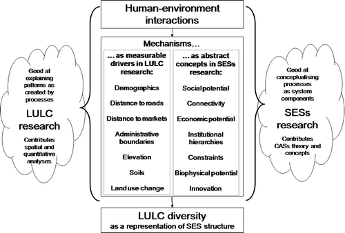
Studying human–environment interactions through the lenses of land-use land-cover change (LULCC) and social-ecological systems (SESs) offers a broader perspective, but each approach faces certain challenges. LULCC research has excellent tools to measure landscape-level change, but is struggling to develop a theoretical framework that is generalized enough to surmount disciplinary boundaries or the complexities of comparisons beyond specific locations (Kuhn Citation1996; Carpenter, Walker, Anderies, and Abel Citation2001; Bürgi, Hersperger, and Schneeberger Citation2004; Walker Citation2004; Perz Citation2007). SESs research, on the other hand, was developed under the umbrella of a broad conceptual framework – that of complex adaptive systems (CASs) – but, with a few exceptions, has been unable to find ways to quantify change (Carpenter et al . Citation2001; Cumming et al. Citation2005; Anderies, Walker, and Kinzig Citation2006). As both these research programs address the dynamics of human–environment interactions, it seems apposite to explore whether the strengths of each can address the weaknesses of the other (see ).
Figure 1. Schematic diagram showing how the divergent SESs and LULCC approaches to the study of human–environment interactions can be linked, both generally as interfaces of such interactions, and specifically with individual underlying mechanisms. For example, the quantitative analyses used in LULCC research call for measurable drivers, or mechanisms, which can be used to represent the more abstract concepts that SES researchers are trying to more abstract. LULC diversity is the proposed link, because it combines a generalized CAS concept with a quantifiable landscape characteristic.
This study tests empirically whether LULC diversity, as a CAS characteristic, responds to the same biophysical and socioeconomic factors that are known to influence change in individual LULC types (Chomitz and Gray Citation1996; Munroe, Southworth, and Tucker Citation2002; Alados et al. Citation2004; Bürgi et al. Citation2004; Crews-Meyer Citation2004; Overmars and Verburg Citation2005; Douglas Citation2006; Erenstein, Oswald, and Mahaman Citation2006; Etter, McAlpine, Pullar, and Possingham Citation2006; Van Gils and Loza Armand Ugon Citation2006). It explores the distribution of LULC diversity in response to elevation, distance to roads, and distance to markets, and evaluates how the resultant distributions compare to hypothesized relationships.
The CASs approach underpinning SESs research emphasizes the dynamism and change inherent in human–environment interactions (Berkes and Folke Citation1998). The key focus is on system resilience – that is, how systems persist and maintain identity as they move through a range of conditions and are subjected to a range of internal and external perturbations (Holling Citation1973; Carpenter et al. Citation2001). The concept of SES resilience is built on the explicit recognition of such systems as being complex and adaptive (Levin Citation1999; Holling Citation2001; Walker and Abel Citation2002; Janssen, Anderies, and Ostrom Citation2007). The empirical, spatially explicit approach of LULCC research allows for the spatial and temporal location of the system to be analyzed (see ). With the increasing abilities of the applications of technologies such as remote sensing and geographic information systems (GIS), researchers can not only measure but also map and model change and dynamism in LULC (Briassoulis Citation2000; Irwin and Geoghegan Citation2001; Verburg et al. Citation2002; Parker, Manson, Janssen, Hoffmann, and Deadman Citation2003; Stibig, Beuchle, and Achard Citation2003; Mas, Puig, Palacio, and Sosa-López Citation2004; Rogan and Chen Citation2004; Wessels et al. Citation2004; Manson Citation2005; Wulder, White, Magnussen, and McDonald Citation2007). The responses of landscape patterns to both local, proximate drivers and larger, more regional factors help researchers understand spatial variability (Turner, Gardner, and O'Neill Citation2001; Geist and Lambin Citation2002; Lausch and Herzog Citation2002; Wood and Porro Citation2002). Here we test whether LULC diversity responds to these drivers, so that this generalized concept can be used to compare conditions in a range of landscapes.
Landscape patterns can be seen as a quantifiable manifestation of the processes that comprise a given SES. As SESs are a type of CAS, we aim to explore LULC patterns as spatial expressions of abstracted CAS characteristics (Odum Citation1975; Turner et al. Citation2001; Geist and Lambin Citation2002; Holling, Gunderson, and Peterson Citation2002; Lausch and Herzog Citation2002; Levin Citation2003; Cumming and Collier Citation2005; Janssen et al. Citation2007) on the landscape and use these generalizations for cross-site comparison. Conceptually, we can apply the metaphors of resilience and sustainability (Levin Citation1999; Holling Citation2001; Walker and Abel Citation2002; Janssen et al. Citation2007) to LULC change: we can evaluate a given landscape to see whether it has retained the same structural (types, number of types, and spatial arrangement of types of land covers) and functional (the goods and services provided by the different land uses) identity, despite shocks and perturbations such as market crashes, or prolonged drought. But can the CAS characteristics that confer resilience be expressed through LULCC, so that we select appropriate indicators? Can LULCC be explained in terms of a CAS? It is with this challenge that our research seeks to engage.
Diversity is a good place to start, as it is the most fundamental CAS characteristic, providing the complexity of components and range of responses required for adaptation (Levin Citation1999). Diversity is also readily applicable to LULC research. The spatial arrangement and distribution of different LULC types define a landscape's diversity. Further, landscape heterogeneity is a familiar concept, and the spatial metrics of diversity derived by landscape ecologists are increasingly being adopted by LULCC researchers (Lausch and Herzog Citation2002; Nagendra, Munroe, and Southworth Citation2004; Cadenasso, Pickett, and Schwartz Citation2007).
Research questions
The patterns of LULC diversity are useful to both LULCC and SESs research because they describe the system as expressed on the landscape and provide generalized information to allow cross-site comparison (Cassidy submitted). LULC diversity patterns should respond to the same mechanisms that are known to affect spatial and temporal variation in the distribution of individual LULC types. The way in which LULC diversity relates to these mechanisms provides important information on the state of the SES.
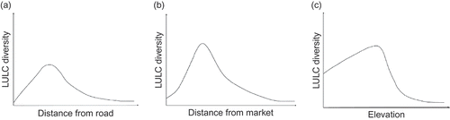
The existing literature shows that across many different study areas, the same mechanisms, primarily hinged on accessibility, will have one or another affect on individual LULC types, though the specific responses may vary, see for example, Kim, Mizuno, and Kobayashi (Citation2003); Southworth and Tucker (Citation2001); Verburg et al. (Citation2002); Walker (Citation2004); Liu (Citation1999); Walker and Soleki (Citation2004). Based on these observed responses and other examples from the literature (see Appendix 1), we can hypothesize the relationships between LULC diversity – as a more generalized concept – and different known mechanisms by assessing how the range of LULC types varies spatially. For example, we expect LULC diversity to be low very close to roads, then increasing sharply within accessible distance to the road, before decreasing steadily (). The most important LULC type in most smallholder farming communities is the dominant crop, and this would be found along rural roads – to the general exclusion of other types. Further from the road, smallholder annual crops are interspersed with less frequently visited areas such as long-term tree crops, pastures, as well as a range of disturbed and undisturbed natural vegetation. Beyond easy foot access, human influence decreases and mainly natural vegetation is found. Likewise, right in the vicinity of the market, LULC types will be low, then increasing strongly with distance, until access becomes a limiting factor, so that LULC diversity tails off with increasing distance. We hypothesize that close to markets, built areas will dominate the landscape, surrounded immediately by only the most important commercial crop, whereas further out commercial crops become interspersed with increasing areas of other smallholder crops and a range of natural vegetation types. As with roads, as human influence drops off, natural vegetation will dominate the landscape (). We suggest that the distribution of LULC diversity with increasing elevation will start off with intermediate magnitudes in low areas, increasing steadily with increasing elevation until steepness and rockiness causes a sudden drop-off in the number of LULC types. Lower areas are more accessible, and will be dominated by the main crop. With increasing elevation, changes in soil and slope make other crops more viable, so the preferred smallholder crops are interspersed with a range of tree crops and other commercial crops, as well as natural vegetation. At higher altitudes, limited access and thin soils make agriculture less viable so only undisturbed natural vegetation is found ().
Figure 2. Hypothesized relationships between LULC diversity and (a) distance to roads, (b) distance to market, and (c) elevation. These schematic diagrams represent polynomial relationships with skewed distributions. The diagrams presented here are intended as predictions for the micro-scale, whereas the higher scales are likely to exhibit smoother curves, with larger intercepts.
We pose the following questions to test whether these hypotheses correctly identify, in two very different landscapes, the nature of these relationships:
-
How does LULC diversity change with distance to roads, distance to markets, and elevation?
-
How do the general relationships between LULC diversity and these factors vary at different scales?
-
To what extent does the actual distribution of LULC diversity agree with that predicted by models describing the hypothesized relationship?
Study area
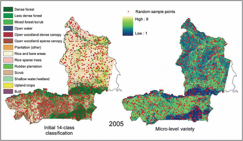
Cross-border studies provide an excellent opportunity for the comparative study of differences in the processes behind LULCC change (Bürgi et al. Citation2004). This study tests the utility of the LULC diversity concept in the neighboring provinces of Sisaket, Thailand, and Ordar Mean Chey, Cambodia, in an analysis of change at four distinct time-steps over a 16-year period from 1989 to 2005. The two provinces currently have highly dissimilar landscape configurations (). We consider the two landscapes to represent the SESs of the two provinces, with the system processes represented by the patterns of four 14-category classifications () of Landsat TM and ETM+ imagery from seasonally comparable dates. The 14 classes, as described in Appendix 2, were identified using data collected by extensive field visits between 2005 and 2006, comparisons with related projects, and earlier maps (Blasco, Bellan, and Lacaze Citation1997; Mekong River Commission Citation2003; Nang Rong Projects Citation2004).
Figure 3. Study area map showing the different spectral characteristics of Sisaket, Thailand, and Ordar Mean Chey, Cambodia.
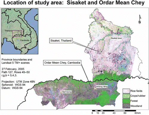
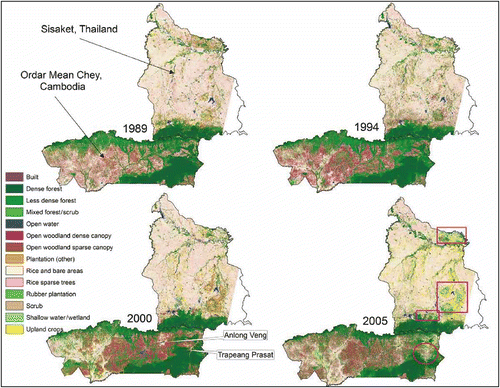
Figure 4. LULC classifications for Sisaket, Thailand, and Ordar Mean Chey, Cambodia, at each time-step in the study period. The circle on the 2005 classification shows the location of the wedge of deforestation in Ordar Mean Chey, whereas the rectangles highlight Sisaket's extreme northeast, escarpment foothills, and three hilly areas, where woodland has given way to upland crops and rubber plantations.
A low escarpment, dropping from Thailand into Cambodia, separates the two provinces. As a result of uplift, the plateau drains north into Thailand, resulting in hydrological separation. Sisaket and Ordar Mean Chey share general edaphic, geomorphological, and climatic characteristics. Both are for the most part flat. A few large rivers cross them, and both were originally covered with semi-deciduous moist tropical forest. They both lie within the Asian monsoonal tropics, and have pronounced, 5- to 7-month, rainy seasons. Currently, however, the provinces have very different landscape configurations, the consequence of different social, cultural, political, and economic histories (Wyatt Citation1984; Chandler Citation2000). In addition, Cambodia's internal struggles since the 1970s have deepened its isolation from the rest of the world.
Sisaket's predominantly agrarian landscape is defined by a dense hub-and-spoke network of mostly paved roads that radiate through a vast expanse of rice fields. Services are good, and all villages have electricity, piped water, and access to health and education facilities. Ordar Mean Chey, in contrast, had no paved roads during the study period.Footnote 1 Because this province was the last holdout of the Khmer Rouge guerrillas, it remained inaccessible to the national government until only recently. As a result, living conditions are very poor. There is no piped water, no public electricity supply, and only a few larger villages have schools and clinics.
As shows, Sisaket's landscape is dominated by extensive areas of rice fields traversed by a few large rivers. The rice cultivation areas, and the forested southern escarpment, have changed little during the study period. More locally, some dynamism in the SES is evident in the change in LULC in the far northeast, in the three hilly areas to the southeast, and in the foothills of the forested escarpment. These areas have transitioned between woodland, upland crops, and increasingly, rubber plantations.
The influence of intensive agriculture evident in Sisaket's landscape provides a marked contrast to that of Ordar Mean Chey. Much of the rice production areas visible in the west of the Cambodian province in 1989 are, according to oral histories, collective farms that collapsed somewhat by 1994 because of ongoing internal conflict between the Khmer Rouge guerrillas and the new government. Areas of woodland expanded with land abandonment, presumably in part because of the presence of land mines. After 1994, the western part of Ordar Mean Chey stabilized, leading to the re-emergence of rice areas. By 2000, the village of Anlong Veng (visible as a small zone of rice around a reservoir due south of Sisaket's western border) expanded, as this part of the province became the last holdout of the Khmer Rouge. The eastern half of this province then began to experience steady deforestation. A key development was the creation of a track through the southeastern forest block in 1994 that opened up the area and led to the expansion of agriculture around the village of Trapeang Prasat. This is visible as a dramatic wedge of rapid deforestation between 2000 and 2005.
Methods
Development of datasets
This spatially explicit study compares the landscapes underlying the two SESs, as described by the classifications shown in , Appendix 2, and discussed above. The 14 classes include several land-use land-cover types that fall on a continuum ranging from dense forest through less dense forest, dense canopy woodland, sparse canopy woodland, rice under sparse trees to treeless rice areas. The classification errors are in part a reflection of the somewhat arbitrary cut-off points imposed along this range. The class ‘scrub/upland crops’ was most difficult to separate from others. This is a result of the classifications being based solely on the spectral characteristics of the satellite imagery, which in some instances are very similar for different LULC classes. The accuracy assessment (see Appendix 3) for the grouped classes resulted in an overall accuracy of 85.5% and Kappa statistic of 0.779. These classifications are taken to be the starting point of this study.
We created raster-based maps of LULC diversity at three different scales (Allen and Starr Citation1982) by running moving windows of 3 × 3, 33 × 33, 303 × 303 pixels (see below) across the four initial classification images. In terms of SESs, we note that decision-making is often made at the household level, contributing to the emergence of pattern at the community or village level. Broader political influences at the national and provincial level provide the context and constraints. Observations in the field, average district and commune sizes calculated from GIS data, and other studies suggest that the spatial extent of these different scalar influences would range from around 1 ha (the order of magnitude of the average household land holding), to the level of interest of a typical commune or district, with order of magnitude of 100 ha, to about 100 km2 – a scale that captures the cumulative effects of about 10 communes while still accommodating variation within the province (Chan, Tep, and Sarthi Citation2001; Mekong River Commission Citation2003; National Statistics Office Citation2003; Van Wey Citation2005). The possible values of LULC variety range from a low of 1 to a high of 14 (because the classifications have a maximum of 14 LULC types). As with any measures of diversity, value ranges are dependent on the scheme's taxonomic resolution, and have some impact on the outcome values. However, the concept used here can be seen to correspond to that of habitat diversity as used in ecology, with the attendant presumption that despite the apparent arbitrariness of class cut-offs, the real variation it simplifies is adequately captured (Kerr, Southwood, and Cihlar Citation2001; Kerr and Astrovsky Citation2003; Foody Citation2008; Gillespie, Foody, Rocchini, Giorgi, and Saatchi Citation2008).
Table 1. Scales of analysis of LULC diversity
Within each moving window, the number of different types was counted and the value is assigned to the central pixel of the window. The elevation map was derived from the 90 m Shuttle Radar Topography Mission digital topographic data, and resampled to 30 m using bilinear interpolation to limit ‘steppiness’ in the dataset.
Because road networks change over time, different ‘distance to roads’ maps were generated for each time-step. In both Sisaket and Ordar Mean Chey, most householders travel and transport their produce by motorcycle. Paved roads and unpaved tracks appeared to be equally accessible for most people, and were therefore treated as equal for this analysis. A substantial number of tracks for Ordar Mean Chey were recorded using a GPS receiver during fieldwork in 2005 and 2006. These were then overlaid over the satellite images for each year, and additional tracks were added or removed according to what was visible in each time-step, to create roads layers for each time-step. In Sisaket, highly detailed roads layers for 2004 were obtained from the Department of Highways and Department of Rural Roads. These were then adjusted according to the satellite imagery. Each time-step's roads layers were then buffered to create the ‘distance to roads’ maps.
Towns with markets were also identified during fieldwork. Although informal trade may also occur, for this study ‘market’ refers to permanent, managed infrastructure established for formal trade in locally grown produce. In Sisaket, a list was obtained from the provincial administration, whereas in Ordar Mean Chey, this information was obtained by visiting all three large villages. Each market was visited, so that geographic coordinates and dates of establishment could be verified. For each time-step, point files were made containing the markets that had been established by that time-step, and buffered to create ‘distance to market’ maps. Although straight-line distance does have some effect, most access to markets is along roads. As both roads and markets showed change over time, we combined roads and markets to create ‘cost–weight distance to market’ maps by assigning 1 to roads and tracks, and 10 to all other surfaces as a simple order of magnitude weighting to constraining the distance to market buffers.
Scale
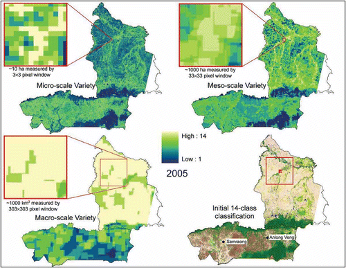
The 30 m pixel resolution of the classifications is small enough to observe both the patterns in LULC diversity and the factors influencing LULCC, even at localized spatial extents. At this resolution and with the smallest possible window size (3 × 3 pixels) – as described below – variation in LULC types at the micro-scale can be measured. In addition, this smallest window size corresponds roughly to 1 ha – the size of the finest scale of analysis (). At 100 ha (corresponding to the community level of interest) enough pixels are present to capture all 14 possible LULC types and to reveal detailed spatial patterns of diversity. Because many social-ecological processes are scale dependent (Allen and Starr Citation1982), we considered three scales of analysis, with the meso-scale of interest corresponding to the sphere of influence of the community (). For the purposes of this study, LULC diversity is assessed on the basis of variety – the number of types of LULC present at each scale.
Analysis
Data exploration showed that all of the variables had strongly non-normal distributions, and for this reason Spearman's rank correlations were used for initial assessment of the relationships. Because the datasets were very large (over 7 million cases), the statistical power is so strong that all relationships are significant with P-values less than 0.0001. In order to assess significance without using the P-values, we compared the correlation and F-test values themselves to the results of the same tests run on 20 different randomizations of the datasets. Because the randomizations had the same distribution as the actual tests, this process showed that the actual test values were not because of chance (Cumming Citation2004).
The Spearman's rank correlation is a good first step in determining whether LULC diversity responds to the same factors that affect individual LULC types, however, the relationship that the test measures is linear. The relationships predicted by the hypotheses are nonlinear, and the correlation coefficients do not capture how the relationship varies with elevation or distance to roads and markets. The shape of the hypothesized curves () suggests instead a multiple-order polynomial relationship, which can be expressed in a general form for all three factors as:
This function was used to create maps of predicted LULC diversity as a response to each of the three explanatory factors, so that these predicted surfaces could then be compared to the actual spatial distribution of LULC diversity. Random samples of 500 pixels per province () were used to generate coefficients for each explanatory factor in each province and at each time-step. The means, variances, and distribution shapes for the samples were compared to those for the entire province datasets to verify that they were representative. The coefficients were identified by running the samples in LAB Fit, a curve-fitting analytical package (Silva and Silva Citation1999–2007) to establish how the actual LULC diversity values in the random samples responded to each explanatory factor within this function. As expected, because the three explanatory factors operate at the local level (results for the Spearman's rank correlations notwithstanding), the functions did not produce good model fits at the meso- and macro-scale. For this reason, although in this article we report the response at each scale, we confine our prediction analyses to the responses of micro-scale LULC diversity only.
Figure 5. Distribution of 1000 random sample points (500 per province) shown relative to the 2005 classification and micro-scale LULC diversity.
The resultant coefficients were then applied to the maps of the explanatory factors using the function described above, to create maps predicting where LULC diversity would be located if that factor alone would influence its distribution. The predictive maps were then subtracted from the actual LULC diversity maps to determine: (a) how much of LULC diversity was explained by that factor, (b) in which locations the predictions were most accurate, and (c) whether the hypothesized shape of the relationship was generally correct.
Results
Spatial distribution of LULC diversity and explanatory variables
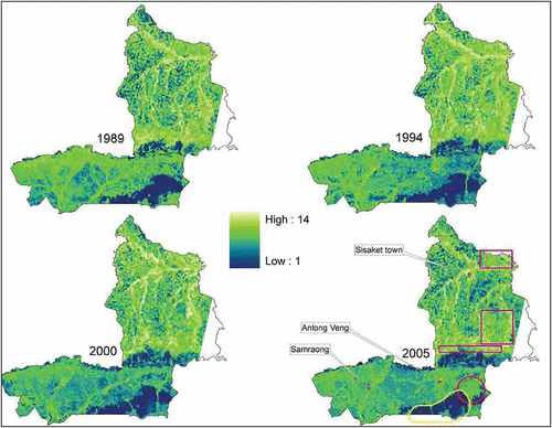
When compared to the classifications in , the predicted values in show that the distribution of LULC diversity imitates the general patterns evident in the changing landscapes of the two provinces. In Sisaket, areas of high LULC variety follow the rivers, and depict the changing agriculture, along the escarpment foothills, and in the three hilly areas in the southeast. The provincial capital, Sisaket town, appears as a circle of high LULC variety in the north-center of the map, just west of the large river junction. In Ordar Mean Chey, the dense forests on the southeastern hills stand out as areas of low LULC variety. The village of Anlong Veng is visible from 1994 onwards as a node of high diversity, with decreasing magnitudes radiating out from the settlement. The development of the road into the dramatic wedge of deforestation is clearly evident as first a line, and then a triangle of higher LULC variety cutting into the low LULC variety of the forested areas.
Figure 6. LULC Variety at the meso-scale for 1989, 1994, 2000, and 2005. Distinct patterns can be followed across the landscape. The circle on the 2005 map shows the location of the wedge of deforestation in Ordar Mean Chey, whereas the freeform shows the low LULC diversity of the dense forests, and the rectangles highlight Sisaket's escarpment foothills and three hilly areas.
A comparison of LULC variety at the three different scales shows that the responses of LULC diversity to underlying biophysical and socioeconomic mechanisms present a smoother response at the meso-scale, allowing the dominant features to stand out (). In addition, the influence of national context is clearly evident in the differences in LULC variety between the two provinces at the macro-scale, with the stronger global economic links in Thailand supporting the existence of a greater range of LULC types.
Figure 7. Spatial distribution of LULC variety in 2005, shown for the three different scales of analysis and in comparison to the initial classification. Each inset, centered on the same riparian area, shows a spatial extent representing roughly 10 times the moving window size used for each scale, to show that the apparent differences are not simply a result of spatial zoom. At the micro-scale, patterns appear more random, whereas those at the macro-scale appear more uniform.
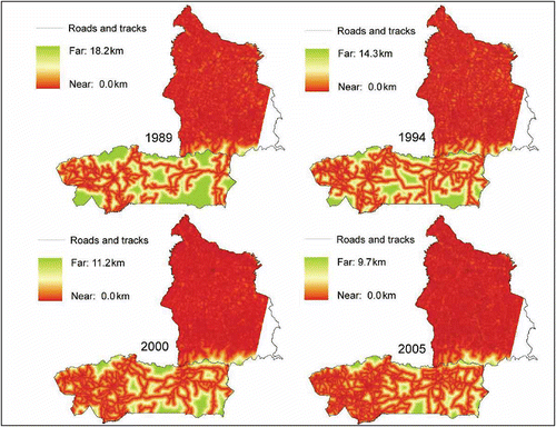
Infrastructural conditions are markedly different in the two SESs. For instance, the road network in Sisaket makes the entire landscape highly connected (). In 1989, the maximum distance to any road was 9.2 km, with a median distance of 200 m. With little room for further road expansion, this median distance remained unchanged through to 2005. In Ordar Mean Chey, not only the number of roads, but also the location of some tracks changed, as is common of dirt tracks in undeveloped areas with low input from government. In 1989, the median distance to road was 1.2 km, with the greatest distance being 18.2 km. By 2005, the median and maximum distances had roughly halved to 0.8 and 9.7 km, respectively.
Figure 8. Distance to roads in 1989, 1994, 2000, and 2005.
In Sisaket, based on date of establishment, the number of markets selling farmers' produce increased from 4 in 1989 to 14 by 2005. As the road network was well established throughout the study period, it was the markets themselves that most changed the cost–weight distance to market across time (). In Ordar Mean Chey, even though no new markets had been established by 1994, access was improved through the development of new tracks.
Figure 9. Cost–weight distance to market in 1989, 1994, 2000, and 2005.
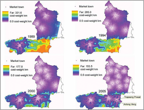
With the establishment of a market in Anlong Veng in 1999, and another in Trapeang Prasat in 2004, the cost–weight distance to market was greatly reduced in the eastern part of the province. However, to some extent the eastern and western halves of the province each retain stronger links to the rest of the country to the south than they do to each other. The roads from Samraong to Siem Reap (a major town south of the study area), and Anlong Veng to Siem Reap, are better established than that linking Samraong to Anlong Veng.
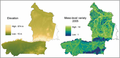
Although Sisaket sits on a plateau above Ordar Mean Chey, the difference between their mean elevations is only about 90 m (). Ordar Mean Chey has a median elevation of 70 m, whereas that of Sisaket is 141.5 m. There is some overlap in the spatial distributions of all of the explanatory factors discussed here. In Sisaket, roads and markets are located only on the lower, flatter areas, and not in the higher, mountainous areas. In Ordar Mean Chey, there has been more change in the relationships. At the start of the study period, settlement and related infrastructure were located in the lower western part of the province, with hills (other than the steep escarpment) found in the east. However, over time roads and settlements have expanded into this slightly more elevated area.
Figure 10. Elevation in the study area shown together with meso-scale LULC diversity in 2005.
Distance to roads and LULC diversity
A comparison of the Spearman's correlation coefficients for LULC diversity and distance to road shows that, overall, Ordar Mean Chey has a much stronger response to distance to roads at all scales, reflecting the difference in road densities between the two provinces ( and ). The negative signs indicate that increasing distance to roads is associated with a decreasing magnitude of LULC diversity at all scales. In both provinces there is a general increase in the strength of the relationship over time at all scales, although this increase is not always constant. In both provinces, the correlations are strongest at the meso-scale, suggesting that it is at this scale the dominant patterns emerge on the landscape (). However, at this broader scale, interactions with other mechanisms are stronger, making it more difficult to model the specific nature of the relationship between LULC diversity and distance to roads.
Table 2. Spearman's correlation coefficients showing LULC diversity in response to distance to roads at each time-step
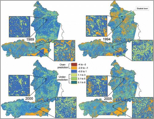
The extent to which the actual relationships match the hypothesized shape in can be seen in and , which shows the predicted response of micro-scale LULC diversity to distance to roads for each time-step for the random sample of 500 points. In Sisaket, only 1989 shows the predicted initial increase, before LULC diversity magnitudes drop off with increasing distance. From 1994 onwards, conditions have changed substantially, suggesting that the actual relationship differs from that hypothesized, with a more linear decrease in diversity with increasing distance to roads. In Ordar Mean Chey a similar shift is observed, but only from 2000 onwards. This delay relative to Sisaket shows the extent to which Ordar Mean Chey lags behind that province in terms of infrastructural development. Although the good fits for all of the functions show that LULC diversity does respond to distance to roads, as expected this factor alone does not explain much of the variance in micro-scale LULC diversity when the function is applied to the entire landscapes ( and ) – with the adjusted R 2 values for Sisaket being particularly low. This implies that although micro-scale LULC diversity does respond to distance to roads, in the province, roads are no longer a major determinant in the distribution of micro-scale LULC diversity. In both provinces, however, the models predict LULC diversity to within one type across about 50% of the landscape (). In Sisaket, the models marginally underpredicted the overall LULC diversity, as is shown by the mean differences between actual and predicted, whereas in Ordar Mean Chey – except in 2005 – the models slightly overpredicted LULC diversity ().
Table 3. Coefficients used to predict micro-scale LULC diversity at four time-steps in Sisaket and Ordar Mean Chey in response to distance to roads in the function 
Table 4. Results of the models predicting micro-scale LULC diversity in response to distance to roads showing goodness-of-fit, proportion of landscape variance explained by the model, mean difference, and standard deviation between predicted and actual LULC diversity for the entire landscapes, and proportion of landscape where predicted LULC diversity is equal to or less than 1 type different from actual LULC diversity
Figure 11. Predicted LULC diversity at the micro-scale in response to distance to roads in the function for four different points in time in (a) Sisaket and (b) Ordar Mean Chey, based on the random sample with n = 500, and using the coefficients generated from modeling the relationship with actual LULC diversity values. Coefficients for the models are given in Table 3.
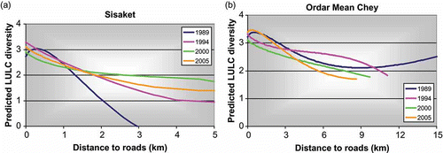
Figure 12. (Available in colour online). Residual map showing the difference between actual micro-scale LULC diversity and that predicted by distance to roads in the function . Orange to red areas show where the model overpredicts LULC diversity, and pale to dark green areas show where the model underpredicts LULC diversity. Insets show arbitrary locations of roughly 4 × 4 km2 to give an indication of the distribution of the residuals when displayed at a finer map scale.
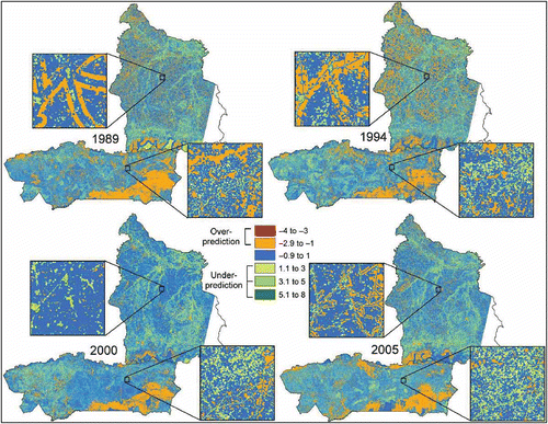
The over- and underpredicted areas on the maps provide important information on what the other factors contributing to the distribution of LULC diversity are. For example, it is clear that at all time-steps in Sisaket, rivers are areas of high LULC diversity independent of the influence of distance to roads (). The inset for Sisaket in 1989 shows that although diversity is correctly predicted immediately next to the road, from about 100 m distance it is overpredicted for the next 250 m as is shown by the distinctive bands paralleling the roads. The residual maps for 2000 and 2005 suggest that the more linear relationship depicted for these years in is a better description of this province's relation to diversity than that hypothesized in . Given the density of the road network in Sisaket (), the fact that distance to roads does not play a major role in explaining the total variation in LULC diversity across the province's landscape is not surprising.
For Ordar Mean Chey, the most striking feature of the residual maps is how the distance-to-roads models overpredict for more elevated areas, adding weight to the hypothesis that elevation is also an important factor influencing LULC diversity. Over time, however, as roads penetrate into the hillier east of the province, the spatial extent of this overprediction decreases (). Rivers do not appear to have the same influence on LULC diversity in Ordar Mean Chey as they do in Sisaket.
Distance to markets and LULC diversity
The Spearman's rank correlation coefficients show that cost–weight distance to market is an important determination of the overall magnitude of LULC diversity (). This is particularly true in Ordar Mean Chey. As with distance to roads, the general trend is for a decrease in magnitude of LULC diversity with increasing cost–weight distance to market. The anomalous positive correlations for Sisaket in 1989 can be attributed to the lack of a market to the southeast of the province until 1994 (), in spite of the presence of the three hilly areas of fertile soil and high LULC diversity highlighted in . Unlike distance to roads, there is no single scale at which the correlations are strongest – instead this varies from year to year. In Ordar Mean Chey, there is a considerable decrease in correlation strength in 2000 at the micro- and meso-scales, but a strong increase at the macro-scale. This relates to the addition of the province's second market, in Anlong Veng (), which reduced the influence of the Samraong market at the micro- and meso-scales, and created more evenly distributed access for the entire landscape.
Table 5. Spearman's correlation coefficients showing LULC diversity in response to cost–weight distance to markets at each time-step
In Sisaket, there has been greater variability over time in cost–weight distance to market compared to distance to roads, and this is reflected in the changing shapes of the models using this factor to predict LULC diversity ( and ). In all years, there is an initial increase before magnitudes drop off with increasing distance, yet not to the degree suggested by the hypothesized curve (). The change in Ordar Mean Chey has been more dramatic. As there was only one market in the province in 1989 and 1994, the addition of a yet another by 2000 almost halved the effective distance to market for the eastern part of the province ( and ). By 2005, both the increase in road density and the addition of a third market have seen the response of LULC diversity change to being almost linear.
Table 6. Coefficients used to predict micro-scale LULC diversity at four time-steps in Sisaket and Ordar Mean Chey in response to cost–weight distance to market in the function
Figure 13. Predicted LULC diversity at the micro-scale in response to cost–weight distance to market in the function for four different points in time in (a) Sisaket and (b) Ordar Mean Chey, based on the random sample with n = 500, and using the coefficients generated from modeling the relationship with actual LULC diversity values. Coefficients for the models are given in Table 6.
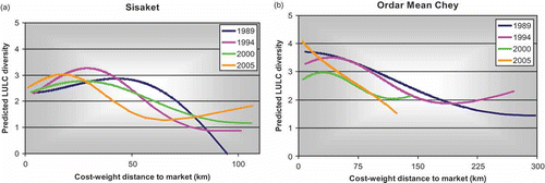
As with those based on distance to roads, the models predicting LULC diversity based on cost–weight distance to market generally underpredicted LULC diversity in the Sisaket landscape and overpredicted for Ordar Mean Chey (). For the most part, cost–weight distance to market better predicts diversity than distance to roads alone, producing models for which 50–64% of the landscape is predicted to be within one LULC type ( and ). The adjusted R 2 values show that in Ordar Mean Chey in 1989 and 1994, market proximity, as a single variable, explained much of the variation in LULC diversity magnitudes across that province's landscape (), and the spatial extent of the overprediction associated with the hilly southeast is reduced, relative to the models for distance to roads ().
Table 7. Results of the models predicting micro-scale LULC diversity in response to cost–weight distance to market showing goodness-of-fit, proportion of landscape variance explained by the model, mean difference, and standard deviation between predicted and actual LULC diversity for the entire landscapes, and proportion of landscape where predicted LULC diversity is equal to or less than 1 type different from actual LULC diversity
Figure 14. (Available in colour online). Residual map showing the difference between actual micro-scale LULC diversity and that predicted by cost–weight distance to market in the function . Orange to red areas show where the model overpredicts LULC diversity, and pale to dark green areas show where the model underpredicts LULC diversity. Insets show arbitrary locations of roughly 4 × 4 km2 to give an indication of the distribution of the residuals when displayed at a finer map scale.
These market models have tended to overpredict LULC diversity in the west of the province for all but 2000 (). In Sisaket, the low adjusted R 2 values again suggest that this province is so highly connected in infrastructural terms that other factors now play a larger role in explaining the spatial distribution of LULC diversity. For example, rivers are again visible as areas for which LULC diversity is underpredicted, as is the area around Sisaket town from 1994 onwards. The 1994 Sisaket map shows large areas of overpredicted diversity, and this model had the lowest total predicted area within one type of the actual LULC diversity ( and ).
Elevation and LULC diversity
Spearman's rank correlation coefficients show that for the whole landscapes, there is a general decrease in the number of LULC types with increasing elevation at all scales (). Again, the relationships are stronger in the less-developed province of Ordar Mean Chey than they are in Sisaket. There is some variability in the scale at which the relationship is strongest at the different time-steps, however, in Sisaket for the most part it appears weakest at the micro-scale, possibly because this linear measurement masks the fact that, at this fine scale, higher LULC diversity is associated with intermediate elevation – with lowest areas dominated by rice, and highest areas dominated by forest (). In contrast, strong relationships are found at the micro-scale in Ordar Mean Chey at all time-steps (), possibly because much of the human-induced change in this province is still taking place in the lower areas to the west of the province ().
Table 8. Spearman's correlation coefficients showing LULC diversity in response to elevation at each time-step
Because elevation does not change over time, we expect less variation in the relation between this factor and micro-scale LULC diversity compared to the relation to roads and markets, and the graphs in and coefficients in show that this is indeed the case. For all time-steps, the shapes of the Sisaket LULC diversity models based on elevation resemble the hypothesized shape () more closely than those of the other factors. The model shapes for Ordar Mean Chey present more abrupt changes with increasing elevation, and also show a second increase in LULC diversity after the initial strong decrease, from about 200 m elevation onwards. This is probably because the eastern half of the province is higher than the western half while still being relatively flat, so that multiple LULC types can emerge (). Overall, LULC diversity in the eastern half is generally lower because this area has had limited settlement because of the area's political history.
Table 9. Coefficients used to predict micro-scale LULC diversity in response to elevation in the function
Figure 15. Predicted LULC diversity at the micro-scale in response to elevation in the function for four different points in time in (a) Sisaket and (b) Ordar Mean Chey, based on the random sample with n = 500, and using the coefficients generated from modeling the relationship with actual LULC diversity values. Coefficients for the models are given in Table 9.
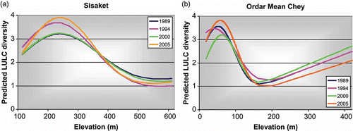
Not only does elevation most closely matched the hypothesized shape predicting LULC diversity but it also predicts most accurately the spatial distribution of LULC diversity, with between 55 and 66% of the landscape being predicted to within one LULC type difference in all time-steps and both provinces ( and ). In Ordar Mean Chey, elevation as a single factor accounts for a lot of the overall variance in the landscape, as is shown by the adjusted R 2 values.
Table 10. Results of the models predicting micro-scale LULC diversity in response to elevation showing goodness-of-fit, proportion of landscape variance explained by the model, mean difference, and standard deviation between predicted and actual LULC diversity for the entire landscapes, and proportion of landscape where predicted LULC diversity is equal to or less than 1 type different from actual LULC diversity
Figure 16. (Available in colour online). Residual map showing the difference between actual micro-scale LULC diversity and that predicted by elevation in the function . Orange to red areas show where the model overpredicts LULC diversity, and pale to dark green areas show where the model underpredicts LULC diversity. Insets show arbitrary locations of roughly 4 × 4 km2 to give an indication of the distribution of the residuals when displayed at a finer map scale.
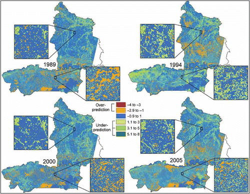
As with distance to roads and cost–weight distance to market, most of the underpredicted areas in Sisaket relate to riparian features, again highlighting their importance in determining the distribution of LULC diversity in this province (). In Ordar Mean Chey in 1994, extensive areas in the northwestern part of the province, which are slightly elevated, are underpredicted, and this is reflected in the mean difference between actual and predicted LULC diversity (), which shows that this year's model performed poorly relative to the other years. In contrast, the underpredictions in 2005 relate to the dramatic wedge of deforestation described in . The residual maps of the elevation-based models for Ordar Mean Chey () show that the hilly southeastern area is well predicted, with errors to the north and west. This is in contrast to the roads- and market-based models, which performed better in the north and south, and overpredicted for the hilly southeast ( and ). This suggests that a model that combined cost–weight distance to market (which includes the influence of roads) and elevation might explain much of the variance in Ordar Mean Chey.
Discussion
Overall, magnitudes of LULC diversity are higher in Sisaket than in Ordar Mean Chey. Likewise, this province clearly has a greater degree of infrastructural development. This means that not only do the two SESs have different potential responses but also differences in the factors affecting the responses. Variations at different time-steps in the relationships with the distance to roads and market variables are to some extent because of changes in these explanatory variables. This does not diminish the importance of the changing LULC diversity values, but instead highlights the importance of other system attributes, such as the connectivity of the SESs. For example, the weaker relationships in Sisaket between LULC diversity and roads and markets suggest a higher degree of connectivity and rigidity to that SES, where human influence has reached a point where it limits the system's response to these factors (Carpenter, Ludwig, and Brock Citation1999; Holling and Gunderson Citation2002). This finding suggests that the strength of the relationship between LULC diversity and the various underlying mechanisms driving LULC change should be explored further as an indicator of the resilience of a given SES. The notion of resilience is important because it draws attention to the fact that SESs move through a range of conditions and are subject to a range of internal and external disturbances. Any management of a SES to maintain a desired state in the long-term needs an understanding of how dynamic and complex the interactions are in the SES under investigation (Berkes and Folke Citation1998; Holling and Gunderson Citation2002).
Roads clearly play a key role in determining the distribution of micro-scale LULC diversity – however, not in the form hypothesized. Although the qualitative shape of the hypothesis was not supported by the models, there is nevertheless an overall decline in LULC diversity with increasing distance to roads, and LULC diversity is shown to be affected by accessibility in the same way as change in individual LULC types. In Sisaket, the road network is so dense, that in this smallholder agrarian system, one is never more than three or four fields away from a road. With the exception of the border escarpment, the low LULC diversity associated with greatest distance from road is related to the dominance of the main smallholder crop – rice, and not undisturbed natural vegetation. Given that nearly all land is within ready access to roads, it appears that close to roads, more economically attractive land uses that tend to cover smaller areas, such as residences, cash crops, and plantations, combined with the diversity associated with road verges (scrub and ephemeral surface water) meaning that in Sisaket LULC diversity is highest close to the road. Even though in Ordar Mean Chey, people may mainly be planting the dominant smallholder crop close to the road, the linear settlement pattern means that here too, diversity is high close to the road, as people tend to have cash and tree crops around their homes, whereas far from the road, as expected, LULC types tend to be restricted to the dominant natural vegetation. This means that the relationship between distance to roads and LULC diversity may be better expressed as a linear decline with increasing distance. Although the specific nature of the hypothesized relationship was not borne out, nevertheless the data show that LULC diversity is affected by the spatial distribution of roads.
Although the hypothesized graph for changes in LULC diversity with cost–weight distance to market suggested large and abrupt change with initial increases in distance, the data show that this trend is more gradual. Nevertheless, the models still show the initial increase in LULC diversity with increasing distance, followed by a decrease, described by the hypothesized left-skewed, inverted U distribution. In Sisaket, the uneven spatial distribution of markets in the earlier years influenced the nature of their relationship to LULC diversity, drawing attention to the issue of feedbacks. As markets became more evenly distributed across the province, the relation to LULC diversity took on a shape closer to that hypothesized, raising the question of how much markets affect LULC diversity and how much they are affected by it.
Although road densities in Sisaket change little over the study period so that access to market was influenced more by changes in the distribution in markets, in Ordar Mean Chey, changes in the roads and tracks played a large role in changing access to markets. The shape of the 1989 model reflects how many roads linked to a single market, and with an additional market in 2000, the model more closely resembles the hypothesized shape. By 2005, however, the addition of a third market in the frontier area of the eastern part of the province where abrupt change is taking place, means that the relationship in the last time-step was almost linear, with high diversity close to the newly established markets, declining sharply as human influence gave way to the densely forested areas.
Encompassed in the effect of elevation on LULC diversity are related factors such as slope and soil. This is most evident in Sisaket, where the three hilly areas of intermediate elevation in the southeast have high LULC diversity primarily because of the richer soils there, whereas the much higher escarpment mountains are very steeply sloped and rocky, limiting human access and use. The combination of these factors contributes to the way in which the models conform to the hypothesized shape. In Ordar Mean Chey, politics have limited the ability of humans to expand their influence into the gently sloped hills of the eastern part of the province, so that at all time-steps in the study period there is an abrupt increase and then decrease in the number of different LULC types within a relatively small elevation range. In the future, as the east of the province opens up, we might expect this transition to be more gradual.
The areas of overprediction in the residual maps for cost–weight distance to market (which incorporates the effect of roads) and elevation clearly show that complementary information is contained in the prediction models based on each of these variables. It would therefore be useful to identify a model that combined cost–weight distance to market (which incorporates the effect of roads) with elevation, as together they would likely explain much of the variance in the spatial distribution of LULC diversity.
Although the models explored here describe the nature of the responses for LULC diversity at the micro-scale only, it is clear from the Spearman's rank correlations that the effect of these local-level drivers can nevertheless also be felt at broader scales. However, at each higher scale of analysis, a larger area is incorporated in the assessment of diversity, which increases the influences and interactions of other processes, making it hard to identify how each variable individually affects LULC diversity at these broader scales. To understand better the distribution of LULC diversity at the meso- and macro-scales, however, it is more important to identify factors that operate at these broader scales. For example, the maps suggest that rivers may control LULC diversity distribution at the meso-scale. The more fertile soils and access to water in riparian areas not only create a greater range of natural LULC types (Naiman and Decamps Citation1997) but also provide the conditions for a range of LULC types – more than individual households could account for, but which collectively a community or village would likely generate. Likewise, a broad-scale mechanism such as degree of integration in the global economy might influence the range of human-dominated LULC types and so better explain macro-scale LULC diversity.
Conclusion
Because diversity, as a system attribute, is quantitative and not categorical, it readily lends itself to measurement. Directional trends can be identified and cross-site comparisons can be conducted empirically, and its association with other SES attributes can be calculated (Carpenter et al. Citation2001; Cumming et al. Citation2005; Cassidy submitted). This study shows that at the micro-scale the hypothesized relationships between LULC diversity and these factors were supported, with some modification to the exact nature of the relationship in the case of distance to roads. Even in the dissimilar systems that the study provinces represented, LULC diversity had the same general responses to factors known to influence LULCC. That is, increasing accessibility and infrastructural development led to increasing LULC diversity in much the same way that they lead to forest conversion and agricultural expansion; and higher elevations constrained LULC diversity just as they do the conversion of one specific type of LULC to several others (Chomitz and Gray Citation1996; Cropper, Puri, and Griffiths Citation2001; Bürgi et al. Citation2004; Crews-Meyer Citation2004; Erenstein et al. Citation2006; Etter et al. Citation2006; Messina, Walsh, Mena, and Delamater Citation2006; Caldas et al. Citation2007; Cassidy submitted).
The way in which LULC diversity relates to these mechanisms provides important information on the state of the SES. Variations in the responses of LULC diversity show that the SESs are adaptive, responding to the influence of the factors tested here. Weakening relationships suggest that a system is becoming more connected. Both the patterns (Cassidy submitted) of LULC diversity and its responses to underlying mechanisms are scale dependent. Although LULC diversity provides a simple but useful generalization for cross-site comparison, predicting its response to different factors requires further development of the theory and the identification of factors more likely to influence spatial and temporal variation at the meso- and macro-scales.
The use of CASs to frame the analysis of landscape change provides a means to integrate SESs research with LULCC research. LULC diversity links the metaphors that guide SES research to the more practical reality of how humans, as the dominant species, influence the spatial configuration of the landscape. The effect of drivers of change on different landscapes can be compared by measuring the response of LULC diversity instead of the responses of individual LULC types which might otherwise be context specific (Perz Citation2007). The condition of SESs can be expressed quantitatively by using LULC types as an expression of SES components. Linking LULCC and SES research allows a system's location in space and time, and at multiple scales, to be included in the evaluation of its past, present, and future states.
Acknowledgements
We are grateful to the Thai Family Research Center, and the University of Chicago-UTCC Research Center in Thailand, and the Center for Khmer Studies in Cambodia for their support during fieldwork for this study. This work was funded in part through the NSF-funded project ‘Economic Growth, Social Inequality, and Environmental Change in Thailand and Cambodia’ project (BCS-0433787).
Notes
1. The first road was paved in late 2005/early 2006.
References
- Alados , C. , Pueyo , C. , Barrantes , O. , Escós , J. , Giner , L. and Robles , A. 2004 . Variations in Landscape Patterns and Vegetation Cover Between 1957 and 1994 in a Semiarid Mediterranean Ecosystem . Landscape Ecology , 19 : 543 – 559 .
- Allen , T.F.H. and Starr , T.B. 1982 . Hierarchy: Perspectives for Ecological Complexity , Chicago, IL : University of Chicago Press .
- Anderies , J.M. , Walker , B. and Kinzig , A. 2006 . Fifteen Weddings and a Funeral: Case Studies and Resilience-Based Management . Ecology and Society , 11 art. 21
- Bassett , T.J. and Zueli , K.B. 2000 . Environmental Discourses and the Ivorian Savanna . Annals of the Association of American Geographers , 90 : 67
- Berkes , F. and Folke , C. 1998 . “ Linking Social and Ecological Systems for Resilience and Sustainability ” . In Linking Social and Ecological Systems: Management Practices and Social Mechanisms for Building Resilience , Edited by: Berkes , F. and Folke , C. Cambridge, , UK : Cambridge University Press .
- Blasco , F. , Bellan , M.F. and Lacaze , D. 1997 . Vegetation Map of Cambodia , Toulouse, , France : Laboratoire d'Ecologie Terrestre de Toulouse .
- Briassoulis , H. 2000 . Analysis of Land Use Change: Theoretical and Modeling Approaches , Morgantown, WV : Regional Research Institute, West Virginia University .
- Bürgi , M. , Hersperger , A.M. and Schneeberger , N. 2004 . Driving Forces of Landscape Change - Current and New Directions . Landscape Ecology , 19 : 857 – 868 .
- Cadenasso , M.L. , Pickett , S.T.A. and Schwartz , K. 2007 . Spatial Heterogeneity in Urban Ecosystems: Reconceptualizing Land Cover and a Framework for Classification . Frontiers in Ecology and the Environment , 5 : 80 – 88 .
- Caldas , M. , Walker , R. , Arima , E. , Perz , S. , Aldrich , S. and Simmons , C. 2007 . Theorizing Land Cover and Land Use Change: The Peasant Economy of Amazonian Deforestation . Annals of the Association of American Geographers , 97 : 86 – 110 .
- Carpenter , S.R. , Ludwig , D. and Brock , W.A. 1999 . Management of Eutrophication for Lakes Subject to Potentially Irreversible Change . Ecological Applications , 9 : 751 – 771 .
- Carpenter , S.R. , Walker , B. , Anderies , J.M. and Abel , N. 2001 . From Metaphor to Measurement: Resilience of What to What?” . Ecosystems , 4 : 765 – 781 .
- Cassidy , L. December 2009 submitted . “ Enhancing landscape change research by linking land-use land-cover change analysis to social-ecological systems concepts: a case study of land-use land-cover diversity in Thailand and Cambodia ” . In Annals of the Association of American Geographers December 2009 , submitted
- Chan , S. , Tep , S. and Sarthi , A. 2001 . “ Land Tenure in Camboida ” . In A Data Update , Cambodia Development Resource Institute . Working Paper 19
- Chandler , D. 2000 . A History of Cambodia , Boulder, CO : Westview Press .
- Chomitz , K.M. and Gray , D. 1996 . Roads, Land Use, and Deforestation: A Spatial Model Applied to Belize . The World Bank Economic Review , 10 : 487 – 512 .
- Crews-Meyer , K.A. 2004 . Agricultural Landscape Change and Stability in Northeast Thailand: Historical Patch-Level Analysis . Agriculture, Ecosystems and Environment , 101 : 155 – 169 .
- Cropper , M. , Puri , J. and Griffiths , C. 2001 . Predicting the Location of Deforestation: The Role of Roads and Protected Areas in North Thailand . Land Economics , 77 : 172 – 186 .
- Cumming , G.S. 2004 . The Impact of Low-Head Dams on Fish Species Richness in Wisconsin, USA . Ecological Applications , 14 : 1495 – 1506 .
- Cumming , G.S. , Barnes , G. , Perz , S. , Schmink , M. , Sieving , K.E. , Southworth , J. , Binford , M. , Holt , R.D. , Stickler , C. and van Holt , T. 2005 . An Exploratory Framework for the Empirical Measurement of Resilience . Ecosystems , 8 : 975 – 987 .
- Cumming , G.S. and Collier , J. 2005 . Change and Identity in Complex Systems . Ecology and Society , 10 art. 29
- Douglas , I. 2006 . The Local Drivers of Land Degradation in South-East Asia . Geographical Research , 44 : 123 – 134 .
- Erenstein , O. , Oswald , A. and Mahaman , M. 2006 . Determinants of Lowland Use Close to Urban Markets Along an Agro-Ecological Gradient in West Africa . Agriculture, Ecosystems and Environment , 117 : 205 – 217 .
- Etter , A. , McAlpine , C. , Pullar , D. and Possingham , H. 2006 . Modelling the Conversion of Colombian Lowland Ecosystems Since 1940: Drivers, Patterns and Rates . Journal of Environmental Management , 79 : 74 – 87 .
- Foody , G.M. 2008 . GIS: Biodiversity Applications . Progress in Physical Geography , 32 : 223 – 235 .
- Geist , H.J. and Lambin , E.F. 2002 . Proximate Causes and Underlying Driving Forces of Tropical Deforestation . BioScience , 52 : 143 – 150 .
- Geoghegan , J. , Wainger , L.A. and Bockstael , N.E. 1997 . Spatial Landscape Indices in a Hedonic Framework: An Ecological Economics Analysis Using GIS . Ecological Economics , 23 : 251 – 264 .
- Gillespie , T.W. , Foody , G.M. , Rocchini , D. , Giorgi , A.P. and Saatchi , S. 2008 . Measuring and Modelling Biodiversity from Space . Progress in Physical Geography , 32 : 203 – 221 .
- Holling , C.S. 1973 . Resilience and Stability of Ecological Systems . Annual Review of Ecology and Systemics , 4 : 1 – 23 .
- — . 2001 . Understanding the Complexity of Economic, Ecological, and Social Systems . Ecosystems , 4 : 390 – 405 .
- Holling , C.S. and Gunderson , L.H. 2002 . “ Resilience and Adaptive Cycles ” . In Panarchy: Understanding Transformations in Human and Natural Systems , Edited by: Gunderson , L.H. and Holling , C.S. Washington, DC : Island Press .
- Holling , C.S. , Gunderson , L.H. and Peterson , G.D. 2002 . “ Sustainability and Panarchies ” . In Panarchy: Understanding Transformations in Human and Natural Systems , Edited by: Gunderson , L.H. and Holling , C.S. Washington, DC : Island Press .
- Irwin , E.G. and Geoghegan , J. 2001 . Theory, Data, Methods: Developing Spatially Explicit Economic Models of Land Use Change . Agriculture, Ecosystems and Environment , 85 : 7 – 23 .
- Janssen , M. , Anderies , J.M. and Ostrom , E. 2007 . Robustness of Social-Ecological Systems to Spatial and Temporal Variability . Society and Natural Resources , 20 : 307 – 322 .
- Kerr , J.T. and Astrovsky , M. 2003 . From Space to Species: Ecological Applications for Remote Sensing . Trends in Ecology and Evolution , 18 : 299 – 305 .
- Kerr , J. , Southwood , T. and Cihlar , J. 2001 . Remotely Sensed Habitat Diversity Predicts Butterfly Species Richness and Community Similarity in Canada . Proceedings of the National Academy of Sciences , 98 : 11365
- Kim , D.-S. , Mizuno , K. and Kobayashi , S. 2003 . Modeling Urbanization by Accessibility in Rapid-Growth Areas . Journal of Urban Planning and Development , 129 : 45 – 63 .
- Kuhn , T. 1996 . The Structure of Scientific Revolutions , Chicago, IL : University of Chicago Press .
- Laurance , W.F. , Alernaz , A.K.M. , Schroth , G. , Fearnside , P.M. , Bergen , S. , Venticinque , E.M. and da Costa , C. 2002 . Predictors of Deforestation in the Brazilian Amazon . Journal of Biogeography , 29 : 737 – 748 .
- Lausch , A. and Herzog , F. 2002 . Applicability of Landscape Metrics for the Monitoring of Landscape Change: Issues of Scale, Resolution and Interpretability . Ecological Indicators , 2 : 3 – 15 .
- Levin , S. 1999 . Fragile Dominion: Complexity and the Commons , Reading, MA : Helix Books .
- — . 2003 . Complex Adaptive Systems: Exploring the Known, the Unknown and the Unknowable . Bulletin of the American Mathematical Society , 40 : 3 – 19 .
- Liu , L. 1999 . Labor Location, Conservation and Land Quality: The Case of West Jilin, China . Annals of the Association of American Geographers , 89 : 633 – 657 .
- Manson , S.M. 2005 . Agent-Based Modeling and Genetic Programming for Modeling Land Change in the Southern Yucatán Peninsular Region of Mexico . Agriculture, Ecosystems and Environment , 111 : 47 – 62 .
- Mas , J.F. , Puig , H. , Palacio , J.L. and Sosa-López , A. 2004 . Modelling Deforestation Using GIS and Artificial Neural Networks . Environmental Modelling and Software , 19 : 461 – 471 .
- Mekong River Commission . 2003 . People and the Environment Atlas of the Lower Mekong Basin , Vientiane : Mekong River Commission .
- Messina , J.P. , Walsh , S.J. , Mena , C.F. and Delamater , P.L. 2006 . Land Tenure and Deforestation Patterns in the Ecuadorian Amazon: Conflicts in Land Conservation in Frontier Settings . Applied Geography , 26 : 113 – 128 .
- Munroe , D.K. , Southworth , J. and Tucker , C.M. 2002 . The Dynamics of Land-Cover Change in Western Honduras: Exploring Spatial and Temporal Complexity . Agricultural Economics , 27 : 355 – 369 .
- Nagendra , H. , Munroe , D.K. and Southworth , J. 2004 . From Pattern to Process: Landscape Fragmentation and the Analysis of Land Use/Land Cover Change . Agriculture, Ecosystems and Environment , 101 : 111 – 115 .
- Naiman , R.J. and Decamps , H. 1997 . “ The ecology of interfaces: Riparian Zones ” . In Annual Review of Ecology and Systematics Vol. 28 , 621
- Nang Rong Projects . 2004 . LULC Classification Scheme , Carolina Population Center, University of North Carolina .
- National Statistics Office . 2003 . “ 2003 Agricultural Census ” . In Northeastern Region , National Statistics Office, Ministry of Information and Communication Technology .
- Odum , E.P. 1975 . Ecology, the Link Between the Natural and the Social Sciences , New York : Holt, Rinehart and Winston .
- Overmars , K.P. and Verburg , P.H. 2005 . Analysis of Land Use Drivers at the Watershed and Household Level: Linking Two Paradigms at the Philippine Forest Fringe . International Journal of Geographical Information Science , 19 : 125 – 152 .
- Parker , D.C. , Manson , S.M. , Janssen , M. , Hoffmann , M.J. and Deadman , P. 2003 . Multi-Agent Systems for the Simulation of Land-Use and Land-Cover Change: A Review . Annals of the Association of American Geographers , 93 : 314 – 337 .
- Perz , S. 2007 . Grand Theory and Context-Specificity in the Study of Forest Dynamics: Forest Transition Theory and Other Directions . Professional Geographer , 59 : 105 – 114 .
- Pontius , R.G. , Shusas , E. and McEachern , M. 2004 . Detecting Important Categorical Land Changes While Accounting for Persistence . Agriculture, Ecosystems and Environment , 101 : 251 – 268 .
- Rogan , J. and Chen , D.M. 2004 . Remote Sensing Technology for Mapping and Monitoring Land-Cover and Land-Use Change . Progress in Planning , 61 : 301 – 325 .
- Silva , W.P. and Silva , C.M.D.P.S. 1999–2007 . LAB Fit Curve Fitting Software (Nonlinear Regression and Treatment of Data Program) V 7.2.34
- Southworth , J. and Tucker , C.M. 2001 . The Influence of Accessibility, Local Institutions, and Socio-Economic Factors on Forest Cover Change in the Mountains of Western Honduras . Mountain Research and Development , 21 : 276 – 283 .
- Stefanov , W.L. and Netzband , M. 2005 . Assessment of ASTER Land Cover and MODIS NDVI Data at Multiple Scales for Ecological Characterization of an Arid Urban Center . Remote Sensing of Environment , 99 : 31 – 43 .
- Stibig , H.-J. , Beuchle , R. and Achard , F. 2003 . Mapping of the Tropical Forest Cover of Insular Southeast Asia from SPOT4-Vegetation Images . International Journal of Remote Sensing , 24 : 3651 – 3662 .
- Turner , M.G. , Gardner , R.H. and O'Neill , R.V. 2001 . Landscape Ecology in Theory and Practice: Pattern and Process , New York : Springer-Verlag .
- Van Gils , H. and Loza Armand Ugon , A. 2006 . What Drives Conversion of Tropical Forest in Carrasco Province, Bolivia?” . AMBIO – A Journal of the Human Environment , 35 : 81
- Van Wey , L.K. 2005 . Land Ownership as a Determinant of International and Internal Migration in Mexico and Internal Migration in Thailand . International Migration Review , 39 : 141 – 172 .
- Verburg , P.H. , Soepboer , W. , Veldkamp , T.A. , Limpiada , R. , Espaldon , V. and Mastura , S.S.A. 2002 . Modeling the Spatial Dynamics of Regional Land Use: The CLUE-S Model . Environmental Management , 30 : 391 – 405 .
- Walker , R. 2004 . Theorizing Land-Cover and Land-Use Change: The Case of Tropical Deforestation . International Regional Science Review , 27 : 247 – 270 .
- Walker , B. and Abel , N. 2002 . “ Resilient Rangelands – Adaptation in Complex Systems ” . In Panarchy: Understanding Transformations in Human and Natural Systems , Edited by: Gunderson , L.H. and Holling , C.S. Washington, DC : Island Press .
- Walker , R. and Soleki , W. 2004 . Theorizing Land-Cover and Land-Use Change: The Case of the Florida Everglades and Its Degradation . Annals of the Association of American Geographers , 94 : 311 – 328 .
- Wessels , K.J. , Defries , R. , Dempewolf , J. , Anderson , L.O. , Hansen , A.J. , Powell , S.L. and Moran , E.F. 2004 . Mapping Regional Land Cover with MODIS Data for Biological Conservation: Examples from the Greater Yellowstone Ecosystem, USA and Pará State, Brazil . Remote Sensing of Environment , 92 : 67 – 83 .
- Wood , C.H. and Porro , R. , eds. 2002 . Deforestation and Land Use in the Amazon , Gainesville, FL : University Press of Florida .
- Wulder , M.A. , White , J.C. , Magnussen , S. and McDonald , S. 2007 . Validation of a Large Area Land Cover Product Using Purpose-Acquired Airborne Video . Remote Sensing of Environment , 106 : 480 – 491 .
- Wyatt , D.K. 1984 . Thailand: A Short History , Chang Mai, , Thailand : Silkworm Books .
Appendix 1. Selected examples of case studies suggesting changes in LULC diversity and underlying factors
Appendix 2. Categories used to describe the landscapes in the study area. The 14 classes form the basis for the analysis of LULC diversity
Appendix 3. Error matrix and producer's and user's accuracy for accuracy assessment of 2005 classification based on 172 reference points