Abstract
You can tell whether a man is clever by his answers.
You can tell whether a man is wise by his questions.
Naguib Mahfouz
This article attempts to provide systematic policy information regarding land use/land cover change in the vicinity of the Giza Pyramids in Egypt. As a result of the rapid urban growth Cairo has experienced in the past couple of decades, a surrounding enclave of urban development seems to be forming around the Pyramids and the highly valued historical legacy of the area, designated in 1979 as a World Heritage site.
Hence, assessing land use changes and future urban sprawl prediction is of major importance for strategic planning and avoiding further endangerment. The data used in this study are derived from remote sensing imagery, taken by Landsat MSS satellite on 31 August 1972 and on 20 September 1984 by Landsat TM as well as Landsat ETM + imagery from 11 November 2000. The use of the different bands of that imagery allowed the classification of the land cover classes: urban, vegetation, desert and water.
A temporal comparison of the different types of land cover indicates which land use changes that have occurred over the years considered are associated with the potential for endangering the Giza complex in the study area.
1. Study area and satellite imagery
Although relations between Western culture and Egypt date back to Roman history, in more modern times, a well-known appreciation of the grandeur of Egypt and its pyramids was Napoleon Bonaparte's declaration to his troops on 17 July 1798: ‘Soldiers! From the heights of these pyramids, forty centuries are looking down on you’.
The magnificent pyramids of Giza and their pyramid complex are located about 25 km from Cairo and comprise the pyramids of Khufu, Khafre and Menkaure. To the east of the pyramid of Khufu, the Sphinx glares protectively at the pyramid complex which encompasses much more than just the pyramids, that is, the ever expanding metropolis of Al Qahirah (meaning ‘the triumphant’) near Cairo – the capital of Egypt and most populous city in the African continent. With a population of approximately 16.25 million (Demographia Citation2008) urban sprawl and growth is evident, and between 1994 and 2001 was estimated to be 2.1% per annum.
The Greater Cairo Metropolitan Area (GCMA) includes two cities, Cairo and Giza, and is spatially distributed over three governorates, Cairo (Al Qahirah), Giza (Al Jizah) and Qaliubiah (Al Qalyubyah), whereas the Greater Cairo Metropolitan Region (GCMR) contains the cities of Cairo, Giza, Shbura El Kheima, five small towns, 10 villages and various contiguous suburban and agricultural areas. There are also five satellite towns: the 10th of Ramadan, 6th of October, Obur, 15th of May and Asalam, which are located adjacent to the boundary of the region but not included (El Araby Citation2002).
The significant population growth of the city as well as the emerging pollution and landscape change call for rigorous monitoring of the cultural endangerment resulting from urban growth caused by the adoption of typical European urban land management models in the African continent (Fekade Citation2000). Urban sprawl and rapid population growth are an unavoidable reality, which often undermines the policy towards land use (Veldkamp and Fresco Citation1994) and the preservation of highly valued cultural heritage (Vaz and Nijkamp 2008). A good example of such a landscape is the pyramids of Giza, which were designated as a World Heritage site by UNESCO in 1979.
Urban growth has been a widespread phenomenon in the world in recent times. It can be defined as the ‘physical pattern of low-density expansion of large urban areas, under market conditions, mainly into the surrounding agricultural areas’ (EEA Report 10/2006). The importance of acknowledging the geographical phenomenon of urban sprawl became clear in the European Spatial Development Perspective where the management of cultural and natural resources was one of the key topics of discussion: ‘Natural and cultural heritage in the EU is endangered by economic and social modernization processes. European cultural landscapes, cities and towns, as well as a variety of natural and historic monuments [,] are part of the European heritage. Its fostering should be an important task for modern architecture, urban and landscape planning in all regions of the EU’ (ESDP, Citation1999, p. 10). Although this argument represents a European version of the dichotomy of urban growth versus the preservation of cultural heritage, Harisson, Fairclough, Jameson, and Schofield (Citation2008) outline the need for a collective sense of the past, lending it a more global character in which the lessons of preservation may be learned for future generations. Cairo has experienced massive urban expansion for demographic, economic and political reasons and this remains nowadays an undoubtable challenge of modernity (Yousry and Atta Citation1997).
The tension between those two realities is typical of the confrontation between modernity and the cultural legacy at the regional level. It has clear spatial attributes and often divergent interests, which have to be regulated in the interests of sustainability. As sustainability becomes a spatial issue with regional inputs, Geographic Information Systems (GIS) can measure the dynamic aspects of spatial decision-making and enable stakeholders to make the best decisions (Gadal Citation2006).
The study area was located at around latitude 29°58′ N, longitude 31°07′ E, and the corresponding reference of path/row for Landsat was 176/39. Satellite imagery, freely downloaded from the Global Land-Cover Facility (GLCF) allowed for a classification of the four main land cover classes (urban, vegetation, desert and water), while enabling land use changes to be monitored over the relevant period.
A limited amount of research has already been performed based on the spatial perception of urban growth in the vicinity of Cairo. This article has as its main objective the development of an urban growth simulation experiment to explore the context of cultural heritage endangerment by using remote sensing imagery. Following the positive results of Rashed, Weeks, Saad, and Hill (Citation2001), we successfully analysed the application of Spectral Mixture Analysis through Multi-spectral Satellite Imagery within the Greater Cairo Region. The combined hard- and soft-classifier methodology responded well in shaping the urban tissue for the Cairo Metropolitan Area. Combined Multi-spectral Satellite Imagery shows an efficient tool for understanding the dynamics of the Cairo region.
By considering urban growth in the different governorates that constitute the GCMA, multi-criteria evaluation (MCE) and predictive scenarios of land use change will allow the definition of those aspects that contribute broadly to environmental and cultural degradation. These issues merge into a conflict between urban development and socio-economic considerations that are crucial for stakeholders.
The scenarios of urban growth are also reviewed in a predictive context, in the hope of identifying factors that are directly related to the urban growth, which now imperils the pyramid complex of Giza. For this, the use of remote sensing imagery is foreseen to create land cover maps of the study area. The assessment and quantification of the degree of urbanization of the land cover maps, as well as the consideration of other important variables such as slope, elevation and urban proximity, will allow the recognition of land use change for future scenarios.
Our article thus has several dimensions of scientific and policy interest:
| • | The development of land cover scenarios for the region based on freely downloadable satellite imagery of Landsat satellites, which suggests that low-budget resources may play an important role in understanding the environmental and urban dynamics from a spatial perspective. | ||||
| • | The creation of simulated suitability maps showing urban tendencies in the various parts of the GCMA. | ||||
| • | Understanding the dilemma of cultural heritage endangerment because of urban growth and environmental degradation in large populated cities with the main focus on tourism. | ||||
2. Methodology
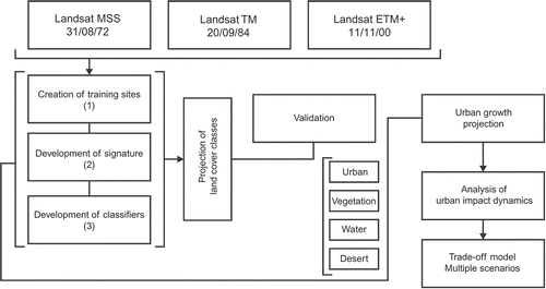
represents the development of the methodology for the creation of land use classes. Image classification presupposes the categorization of Landsat imagery pixels into clearly defined land cover classes. In this context, Landsat satellite imagery has been shown to provide accurate data for spatio-temporal analysis (Bédard, Reichert, Dobbins, and Trépanier 2007). The process of supervised classificationFootnote 1 consists of three steps: (1) identifying training sites, representing areas and developing a numerical description of the electromagnetic spectrum attributes; (2) classification of each pixel in the image into a land cover class; and (3) production of thematic maps showing land cover in the study area (Lillesand, Kiefer, and Chipman Citation2004). The creation of land use maps because of advances in satellite image receptors and their application/use allows us with some accuracy to observe land use changes at different moments in time. This is particularly the case in regions that have not previously been intensively and regularly mapped, leading to the development of scientific methodologies for land cover analysis and the development of topographic maps. In the process of generating land cover, they are validated by geo-referencing vector points onto Google Earth (GE). The novelty of this approach, contrary to common validation methodologies based on topographic 1:100,000 maps, is essentially based on the interest of analysing the low-budget possibilities of land use change in an attempt to deliver an ‘available to many’ scientific approach to spatial environmental analysis. Therefore, satellite imagery data were downloaded from the GLCF (http://www.land-cover.org/index.shtml). These data are available for downloading from Landsat MS, TM and ETM + satellites.
Figure 1. Methodology for the creation of land cover classes.
Once our subsets of classes are validated, urban growth will be projected based on suitability maps derived from the results of MCE.
The maps generated by MCE allow stakeholders to have the possibility of analysing multiple alternative scenarios that represent trade-offs of different strategic options. The existence of multiple choice possibilities (or alternatives) represented by different scenarios is the very essence of MCE, where the various alternatives are evaluated on the basis of a series of conflicting and incommensurate criteria (Malczewski Citation1999). Our approach is based on a weighted ranking procedure.
This approach is supported on a generated suitability map that is then spatially analysed by the stochastic comparison of urban change in the different generated land use maps. Artificially constructed (i.e. urban) areas will assemble the weight factor of each of the multi-criteria variables in the analysis. By cross-tabulating this information with derived socio-economic data such as employment per region of the GCR, we will then assemble multi-choice scenarios that allow stakeholders to identify the best possible strategic choices in connection with the following dilemmas: more/less tourism; employment and urban growth challenges; cultural heritage endangerment versus employment and tourism.
3. Comparing types of land covers
The suggested methodology allows the identification of various types of land use cover with high accuracy. Thus, 1972, 1984 and 2000 land cover maps are obtained from the raw image data from the Landsat MSS, TM and ETM + data.
The combination of available electromagnetic spectrum ranges allowed the application of minimum distance classifiersFootnote 2 . Based on the existing land use classes of urban, vegetation, water and desert, a combination of red (band 3), green (band 2) and blue (band 1) was chosen. The creation of vector training sites with clear land cover classes allowed the development of signatures that led to the creation of the classifiers. The classification stage consists of categorizing each pixel in the image dataset into the land cover class it most closely resembles. The varying spatial unit size from MSS to TM and ETM + led to the conversion of the same unit size of 80 m over all three temporal satellite layers. This allowed the multi-temporal assessment, which otherwise would have been limited without a similar largest pixel size. This specific size focused on the Landsat MSS data as reference to have a minimum comparable unit.
Land Use and Land Cover Change (LUCC) models are important tools for the appraisal of environmental change because of their capability to quantify human aspects of environmental dynamics, which is of growing importance in identifying the subtleties of the rural versus urban dichotomy (Lambin et al. Citation2001). LUCC models tend to become, therefore, multi-agent systems that allow inference to be made about the quantitative effects of land use change derived from the application of econometric and statistical tests (Parker, Manson, Janssen, Hoffmann, and Deadman Citation2003).
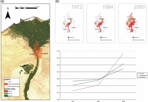
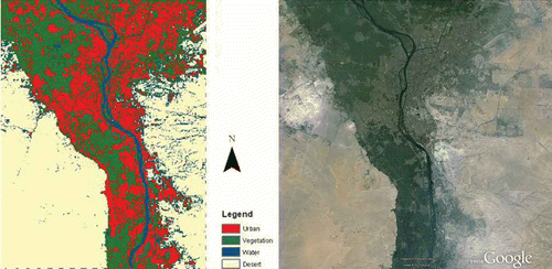
a shows the exact location of the study area in the GCMA and the temporal comparison of the extrapolated types of urban land cover from the satellite imagery. Pixel quantification allowed the generation of temporal strata, which led to a dynamic comparison of the evolution of urbanism (see the trend graph in b). This allows us to conclude that, although urban growth has been continuous over the three decades covered by our observed spatial assessment, the evolution of urban growth in the governorates is not constant, as each of the three governorates clearly presents a distinct path of urban growth. For instance, the governorate of Al Qalyubyah seems to expand much more rapidly than Al Jizah or even the main Governorate of Al Qahirah. In contrast to what might have been expected, Al Qahirah, which had the highest amount of built-up land in the beginning of the 1970s, has experienced the lowest urban growth in the following 30 years. Furthermore, for all the three areas urban growth seems to be especially significant between 1984 and 2000.
Figure 2. (a) Study area and (b) urban growth comparison.
The apparent inexplicable differences in urban growth in the different governorates around the periphery of the capital create an interesting opportunity for multi-variant decision-making by the use of multi-criteria analysis. As policies may vary due to the context of economic, social and environmental perception and, hence, influence urban growth, our research agenda covered the following phenomena: (1) tourism growth among the governorates by measuring both hotel density and the regions' attractiveness in terms of cultural heritage provision per governorate and (2) population trends by the analysis of population growth within the boundaries of the governorates. Comprehension of these intertwining aspects requires multi-criteria decision rules that allow the quantification of what particular factors have a higher or lower weight in the development of urbanism in the study area.
Defining the future trends of all these specific dimensions will contribute to a more profound understanding of the direct impacts of tourism and/or socio-economic factors on cultural heritage.
4. Modelling urban growth in Cairo
LUCC modelling presupposes implicit but systematic knowledge of the explanatory variables or drivers of urban growth. As suitability maps represent a synthesis of different variables, they become of utmost importance for identifying and imposing critical weights that add to changes in land use. High values on the generated suitability maps indicate a higher propensity for the existence of a specific type of land use, whereas a lower propensity represents a lower tendency for land use change in these areas. The matrices generated by the GIS-engendered raster format allow a MCE system that imports different sets of explanatory variables, including contextual variables and policy developments (Voogd Citation1983).
4.1. LUCC and satellite imagery interaction
The information content of the LUCC model, combined with raw remote sensing datasets, offers therefore a unique chemistry to explore the possibilities of quantifying future land use scenarios.
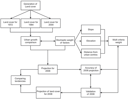
maps out the various methodological stages of our research. Although this figure represents the overall process of understanding urban growth, its complexity should be assessed in the context of trade-off opportunities that may arise from economic, social and political conditions. As the three governorates concerned may develop different strategies, options regarding the growth of a mass tourist industry that has excelled in the region since the beginning of the twentieth century should be articulated with global concerns on the imminent vulnerability of cultural heritage. By filtering the projected 2008 data, artificial (urban) land use developments may be derived and compared next to, for instance, a future LUCC scenario in 2038. The comparison of both new time frames establishes the relation between the consequences of future land use in the context of a multi-criteria analysis, in which a variety of policy-relevant variables are considered to assess the overall endangerment in the Cairo region. Also, a qualitative visual analysis was carried out, which allowed to assess the validity and compatibility of the georeferenced data imported from shape files. Co-registration of satellite data and thus of future land use scenarios were verified by the visual perception of retrieved data.
Figure 3. Methodology for urban growth assessment.
Acquiring spatial knowledge in a temporal context should allow the creation of predictive models based on weighted initial data. The latter are an outcome of MCE with respect to land cover defined criteria through statistical methodologies (e.g. logistic regression). Additional constraints (e.g. Boolean sets of conditions of restraint) as well as trade-off factors, which articulate their influence on a given cell value, concisely express what we may call a suitability map.
4.2. Multi-criteria evaluation for suitability maps
The suitability maps reflect those environmental characteristics that are important for an objective interpretation of future land use scenarios. The propensity for urban growth becomes evident, and may thus be better understood, in the context of urban planning and decision-making. expresses the factors and constraints for our model, as well as for the derived maps. The choice of the fundamental variables that explain urban growth is based on bibliographic research on the subject, as well as on the common sense of planning strategies and elementary geographical notions. In this context, Hofstee and Brussel (Citation1995) highlight the importance of proximity to the city centre, directly adjoining the previously built area. Chen et al. (Citation2002) and Clarke and Gaydos (Citation1998) show the intrinsic relation between urban growth and slope derivatives, because areas with a high slope clearly represent less tendency to become built-up (Clarke and Gaydos Citation1998; Chen et al. Citation2002; Vliet, White, and Dragicevic Citation2009).
Table 1. Factors for multi-criteria urban growth modelling
The weight of each of the variables may be expressed by the following formula:
The specification of this model in the form of a combination over the series of classes represents essentially an unrestricted logistic regression over space, of which empirically estimated equations may be derived to fit our suitability map. shows the statistical tests (standard deviation, average, t-statistic and R 2, as well as the final regression model per variable).
Table 2. Statistical tests used for variable weights over space (spatial units in km2)
The existing city centre was excluded from the 1972 created land cover, and Euclidean distances were measured from the perimeter of the central area. Urban sprawl was expected to occur adjacent to existing urban growth, given the laws of urban contiguity and the proximity of previously existing urban areas resulting from existing network and available infrastructures.
The suitability map becomes therefore a synthesis map that allows the simulation of ideal choices of urban growth and is a result of the recognition of independent variables that contribute directly to the behaviour of urban growth at the spatial level, and at the same time becoming ‘significant for land use planning to exploit potential capacity of land, to increase food production and income with effective use and sustainable development of land’ (Zhou, Liu, Xu, and Chu Citation2005, p. 2426).
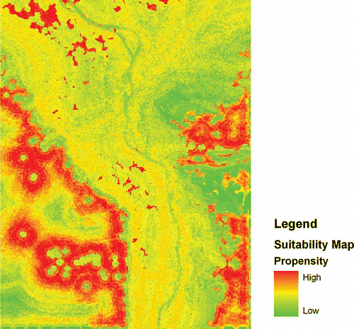
Our overall analysis of the suitability map () shows a tendency for future urban growth in peripheral areas, but located relatively near to previously existing urban centres.
Figure 4. Suitability map and propensity for urban growth.
The perception of each individual map as a criterion map with specific user-defined weight gives it the characteristics of a multi-criteria decision model (MCDM). Each criterion map is combined with the others, leading to the suitability map with capabilities to predict urban propensity. Constraints and criteria should be very well defined and preferably reflect users' intuition and bibliographic support. The success of the MCDM is a consequence of the extrapolation of the final result of the suitability map and its projection to a known time frame (2008), as is proposed later.
The generated criterion maps were next reclassified into the scale 0 (minimum propensity) to 255 (maximum propensity), which allowed the comparison of individual values of propensity (Eastman Citation2006) and corresponded to a MCE of a weighted linear combination, taking for granted the existing constraints, defined by previously built-up areas and the land cover classification water, as well as the input criterion factors. Multi-criteria weighting was done by pairwise comparison of factors on a nine-point continuous rating scale with values ranging from 1/9 to 1 (less important: completely unimportant to equally important) and 1 to 9 (more important: equally important to completely important) as proposed by the analytical hierarchy process model (Saaty Citation1977).
The following relations were established based on these criteria (see ): Eigenvectors were generated based on the existing weights to establish a comparative factor weight for each of the independent variables, with a consistency ratio of 0.09, which is acceptable for this purpose.
Table 3. Weight criteria for MCE
The results clearly show the importance of urban change and urban proximity and elevation while attributing some weight to distance from roads and less in this case to slope (as we noted previously, there was little variation in slope in the built-up areas in the studied area, although this variable often has some importance).
Finally, the suitability map was generated on the basis of the inserted eigenvectors in addition to the logistic regression of each variable. The result thus corresponded to a multi-criteria transition assemblage predicting a transition towards urban change for the Cairo study area given by the following equation:
The suitability map detected a tendency for the growth of urban sprawl outside the original city perimeter. A strong tendency for a denser urban area seems apparent on the western side of the GCMA, whereas to the east, in the Governorate of Al-Giza, the formations of 1972–1984 urban nuclei have become seeds for sprawling urban development.
Construction in the desert might occur less, but the substitution of vegetation areas by urban use becomes an evident phenomenon. A prominent mass of urban areas appears to occur just north of the Giza Pyramid complex, alerting us to the possible consequences of ongoing urban growth on areas with valuable and vulnerable cultural heritage.
4.3. Transition probabilities and Markov chain analysis
Land cover knowledge for future land use projection was based on Markov chain analysis, which allows land cover to be compared at two different points in time. Transition from one class can be quantified and gives a clear indication of future land use (Bell Citation1974). MCE has been shown to have the capacity to describe LUCC independently of the persistence of certain trends, serving as a rich indicator for future land use projections (Weng Citation2002). By means of a transition matrix (), probabilities of land change are associated with the strength of each cell value. These represent the overall changes in land use between the initial period of 1972 compared with that of 2000.
Table 4. Markov chain analysis of probability of transition to the various land cover classes
Some interpretation becomes feasible and consistent after converting the generated pixel quantification into a percentage cross-tabular matrix where the rows represent actual cell values and the columns Markov transition propensities.
A clear tendency for urban growth is visible, and changes regarding this specific class primarily involve a change from vegetation to urban areas, followed by further expansion into desert areas. The propensity for water areas to change use into urban areas seems unlikely, and the 5.37% value may be explained by a misapproximation resulting from the created land cover. Nevertheless, this value does not hinder the correct assessment of urban growth, as the presence of water is used as a constraint in the projection scenarios projected for 2008 and 2038.
4.4. Use of cellular automata for projecting urban growth
Urban growth projection for 2008 () was achieved by combining the probability transition matrix calculated by MCA and the suitability map (representing the calculated logistic regression factors) and constraints (water areas and existing urban areas in 1984). This hypothetical transition served as the starting point to generate a Cellular Automaton that encapsulated the suitability map and the relative propensities of urban growth, as well as the probability matrix of land class changes in land use maps (Clarke and Hoppen Citation1997). The result is a projected land cover for 2008, which must be assessed on ground truthFootnote 3 .
Figure 5. Compiled land cover and corresponding satellite imagery area (© 2010 Google, Map Data © DigitalGlobe, Map Data © Geolayer).
In the next step, 200 vector points were randomly created and distributed along the defined 2008 urban areas and projected onto Google Earth™ for validation. The random distribution extent was applied by choosing among the urban mask 100 vector points that shared urban land use and 100 vector points with non-urban land use.
This allowed assessment of the adequacy of modelled urban growth onto a ground truth surface. The measure of agreement for urban areas is indicative of the global accuracy of the 2008 projection and the validity of urban prediction. Our global validity is demonstrated by 176 correctly classified vector points as opposed to 24 wrongly classified (see ). A satisfactory accuracy of 88% for correctly classified points pointed out the possibility of considering the projection with the same variables to the time frame of 2038.
Table 5. Global accuracy of urban projection in 2008
As not to bias the results with less accurate georectification based on (GE), a layer used as a mask with the specific locations of the districts was projected on GE as to assess the ground truth of information of the high spatial resolution data used in GE satellite imagery. This layer, projected into WGS 1984 datum, permitted to assess the boundaries of the different governorates with clear defined geographical limits: From the 29 existing governorates, the geographical barriers of Cairo, Giza, Qalyubia and Helwan. These governorates are located along the Nile banks, which allowed a clear visualization of the limit regions and assess the correct projection and information on GE.
5. Projecting urban growth for 2038
The chosen criteria of slope, elevation, urban proximity and road distance seemed to be adequate to project urban growth for 2008 as proved by the spatial validity of the modelled land cover. Uncertainty in urban projection is a permanent problem, as urban growth will necessarily be dependent on developments caused by politics, policies and stakeholders. The visualization of future scenarios is, therefore, a result of the hypothetical interpretation of future occurrences, and should only be seen as an informative support to decision-making and not as an accurate predictive truth (Paegelow and Olmedo Citation2005). The accuracy of results for 2008 allowed us to project a future scenario based on the same factors and constraints, where constraints now represented the derived water and urban coverage for 2000. Probability changes were measured based on the comparison of Markov transitions between 2000 and 2008, and by then projecting the probability of land use change for 2038. The result is depicted in below. As we may observe, there is a clear tendency for loss of vegetation areas. However, even though vegetation continues to be occupied by urban areas, some vegetation areas should for ecological reasons remain intact in the next 30 years. An example of this is the beautiful vegetation area located northeast of the pyramid of Khufu in the vicinity of the village Nazlet el Samman. This specific vegetation area supports the existence of the popular Mena House Oberoi Golf course. Allowing the co-existence of tourism and sustainability of cultural heritage, this location does not have to change in the forthcoming years until 2038. This shows that in terms of urban planning, touristic infrastructures may be envisaged for integrating sustainable options, so that further planning initiatives dealing with this question might be considered.
Figure 6. Urban growth projection for 2038.
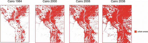
It is expected that the village of Nazlet el Samman will continue to grow further because of its proximity to the dominant traditional urban areas and to road networks. Northern Giza seems to be expanding rapidly, as new buildings and complexes developed at the beginning of 2000 with the creation of subsidiary roadworks seeming to create by 2038 even greater urban growth. These new urban areas are now generating – and will be expected in future to encompass – an even broader and denser area surrounding, for instance, the pyramid complex of Giza.
6. Conclusions
In the coming decades, the delicate nature of cultural heritage around the GCMA, such as the different pyramid complexes and in particular the pyramid complex of Giza, could be in imminent danger because of the rapid expansion of urban growth. By 2038, it is expected that the pyramid complex of Giza in Cairo may be completely engulfed by the glass and concrete infrastructures of the twenty-first century urban growth. By analysing satellite imagery and creating land cover maps for this specific area, our study demonstrated that it was possible to obtain a broader view on the concept of spatial urban growth in a World Heritage site over a larger period of time.
The remarkable tendency for urban sprawl in the area since the 1980s shows the link between classifications of world heritage and the unpredictable consequences of having heritage tourism attractions in the long run. Population increase in Egypt has been in evidence since the past 50 years, but, nevertheless, it is with the creation of tourist infrastructures, which provide proximity to tourist attractions, that urban spatial sprawl is induced and becomes even denser until the beginning of 2008.
The construction of the Grand Egyptian Museum (GEM) in the vicinities of the El-Remaya square in Giza may have an interesting role in preserving the heritage sites as it may lead to proper urban growth and avoid unclassified urban sprawl. The timely location about 3 km from the pyramid complex is therefore an important venture that might help to reshape the current northern Al Jizah fringe. If correctly managed, the GEM could be a surprisingly interesting example of site requalification to support concentrated and planned urban growth in Cairo. The current budget acts like an ‘intersection between Modernity and Antiquity, literally redirecting the traveller from the modernity of Cairo and Alexandria to the Ancient Heritage of the Ancient Heritage of the Egyptians which goes back to over 5000 years of civilization’ (GEM website), redefining a joint effort of modern urban planning in context with ancient heritage sites.
It has become clear that satellite imagery may become an important tool for the assessment of World Heritage sites, and those proactive measures should be taken seriously to avoid endangerment of fragile artificial heritage.
Urban growth may in the medium run be a pernicious consequence leading to unavoidable harm because of pollution and land change at the expense of valuable cultural heritage. The analysis of future urban scenarios has also shown that new construction in the area of the pyramid complex of Giza shows the creation of new networks and new infrastructures in which urban development tends to use tourist attraction as a way to explore the possibility of future urban growth, but should be carefully managed and handled strategically under the GEM initiative. Another concerning issue is the consequences on urbanization of the GCMA regarding population growth. As analysed by Shahin (Citation1990) a linear correlation is seen between total consumption of surface and groundwater and its effects on the groundwater rise related to population increase. Further rise on groundwater levels is expected as population increases, which is strongly linked to urbanization.
The objective of this study has brought to attention – besides the potential of the use of satellite imagery for heritage perception and preservation in less geographically studied areas – the importance of heritage preservation and the assessment of urban growth, on which future work should focus as the key factors of economico-environmental sustainability based on the knowledge of those pollution and destructive factors that directly influence the land use and environmental changes in a given area. Regional knowledge is intrinsic to spatial understanding (Massey Citation1979), and this justifies the computation of spatial models as important tools for urban and planning sciences. From this perspective, local knowledge of the trade-off factors that influence spatial contexts, such as environment and cultural heritage, seems an important asset that allows more accurate sustainability policies.
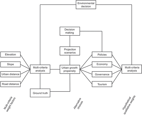
shows the multi-criteria process involved in constructing the architecture of the possible relations involved in choices concerning future land occupation, social and governance choices and policies. Although we have analysed the complexity of urban growth in the context of stochastic probabilities and, hence, have predicted future urban occupancy, in addition MCE may be seen as a very effective tool for land use analysis (Beinat and Nijkamp Citation1998). It shows the implications of different choices in a toolbox of effective decision-making, which combines MCE with spatial analysis methodologies and GIS, as was exemplified by the integration of spatial decision support systems. This also highlights, in a context of both social, political and economic trade-offs and governance fragmentation, the intrinsic environmental complexity for regional decision-making.
Figure 7. Spatial and regional complexity for environmental decision-making.
Acknowledgements
We thank the reviewer for the very important and relevant suggestions, which were very helpful and an important source for the enhancement of this article.
Notes
1 This is a classification function that predicts output results based on selected input attributes chosen manually by the user.
2 This concerns a supervised classification method based on the creation of a multidimensional space defining distinct classes of land-cover. The pixels are assigned in the classification process to the closest land-cover class.
3 This term is used in cartography, meteorology and remote sensing and corresponds to the information collected on location or from an aerial photo with a more accurate perception of reality.
References
- Bédard , F. , Reichert , G. , Dobbins , R. and Trépanier , I. 2008 . Evaluation of Segment-Based Gap-Filled Landsat ETM + SLC-off Satellite Data for Land-Cover Classification in Southern Saskatchewan, Canada . International Journal of Remote Sensing , 29 ( 7 ) : 2041 – 2054 .
- Beinat , E. and Nijkamp , P. , eds. 1998 . Multicriteria Analysis for Land-use Management , Dordrecht : Springer Verlag .
- Bell , E.J. 1974 . Markov Analysis of Land Use change: An Application of Stochastic Processes to Remotely Sensed Data . Socio-Economic Planning Sciences , 8 : 311 – 316 .
- Chen , J. , Gong , P. , He , C. , Luo , W. , Tamura , M. and Shi , P. 2002 . Assessment of the Urban Development Plan of Beijing by Using a CA-Based Urban Growth Model . Photogrammetric Engineering & Remote Sensing , 68 : 1063 – 1071 .
- Clarke , K. and Gaydos , L. 1998 . Loose-Coupling a Cellular Automaton Model and GIS: Long-Term Urban Growth Prediction for San Francisco and Washington/Baltimore . International Journal of Geographic Information Science , 12 ( 7 ) : 699 – 714 .
- Clarke , K.C. and Hoppen , S. 1997 . A Self-Modifying Cellular Automaton Model of Historical Urbanization in the San Francisco Bay Area . Environment and Planning B: Planning and Design , 24 : 247 – 261 .
- Demographia (2008), “World Urban Areas (World Agglomerations) Population and Density, 08/2008,” http://www.demographia.com/db-worldua.pdf (http://www.demographia.com/db-worldua.pdf)
- Eastman , J.R. 2006 . IDRISI Andes Tutorial , Worcester, MA : Clark Labs .
- EEA (European Environment Agency) (2006), “Urban sprawl in Europe – The ignored challenge, 10/2006, (Copenhagen: European Commission),” http://reports.eea.europa.eu/eea_report_2006_10/en (http://reports.eea.europa.eu/eea_report_2006_10/en)
- El Araby , M. 2002 . Urban Growth and Environmental Degradation – The Case of Cairo, Egypt . Cities , 19 ( 6 ) : 389 – 400 .
- ESDP (European Spatial Development Perspective) (1999), “Towards Balanced and Sustainable Development of the Territory of the European Union,” Luxembourg: European Commission http://ec.europa.eu/regional_policy/sources/docoffic/official/reports/pdf/sum_ en.pdf (http://ec.europa.eu/regional_policy/sources/docoffic/official/reports/pdf/sum_ en.pdf)
- Fekade , W. 2000 . Deficits of Formal Urban Land Management and Informal Responses Under Rapid Urban Growth, An International Perspective . Habitat International , 24 : 127 – 150 .
- Gadal , S. 2006 . “ Urban Multilevel Geographical Information Satellite Generation ” . In GIS for Sustainable Development , Edited by: Campagna , M. 313 – 329 . Boca Raton, FL : CRC Press, Taylor and Francis Group .
- Harisson , R. , Fairclough , G. , Jameson , J.H. JR and Schofield , J. 2008 . “ Heritage, Memory and Modernity ” . In The Heritage Reader , Edited by: Fairclough , G. , Harisson , R. , Jameson , J.H. Jr. and Schofield , J. 1 – 12 . New York : Routledge .
- Hofstee , P. and Brussel , M. 1995 . Analysis of Suitability for Urban Expansion in Villavicencio, Colombia , Enschede, , Netherlands : International Institute for Geo-Information and Earth Observation .
- Lambin , E.F. , Turner , B.L. , Geist , H.J. , Agbola , S.B. , Angelsen , A. , Bruce , J.W. , Coomes , O.T. , Dirzo , R. , Fischer , G. , Folke , C. , George , P.S. , Homewood , K. , Imbernon , J. , Leemans , R. , Li , X. , Moran , E.F. , Mortimore , M. , Ramakrishnan , P.S. , Richards , J.F. , Skanes , H. , Steffen , W. , Stone , G.D. , Svedin , U. , Veldkamp , T.A. , Vogel , C. and Xu , J. 2001 . The Causes of Land-Use and Land-Cover Change: Moving Beyond the Myths . Global Environmental Change , 11 ( 4 ) : 261 – 269 .
- Lillesand , T.M. , Kiefer , R.W. and Chipman , J.W. 2004 . Remote Sensing and Image Interpretation , 5th , Danvers, MA : John Wiley & Sons .
- Malczewski , J. 1999 . GIS and Multicriteria Decision Analysis , New York, NY : John Wiley & Sons .
- Massey , D. 1979 . In What Sense a Regional Problem? . Regional Studies , 13 : 233 – 243 .
- Paegelow , M. and Olmedo , M.T. 2005 . Possibilities and Limits of Prospective GIS Land-Cover Modeling – A Compared Case Study: Garrotxes (France) and Alta Alpujarra Granadina (Spain) . International Journal of Geographical Information Science , 19 ( 6 ) : 697 – 722 .
- Parker , D.C. , Manson , S.M. , Janssen , M.A. , Hoffmann , M.J. and Deadman , P. 2003 . Multi-Agent Systems for the Simulation of Land-Use and Land-Cover Change: A Review . Annals of the Association of American Geographers , 93 ( 2 ) : 314 – 337 .
- Rashed , T. , Weeks , J.R. , Saad , M.S. and Hill , A.G. 2001 . Revealing the Anatomy of Cities through Spectral Mixture Analysis of Multispectral Satellite Imagery: A Case Study of the Greater Cairo Region, Egypt . Geocarto International , 16 ( 4 ) : 7 – 18 .
- Saaty , T.L. 1977 . A Scaling Method for Priorities in Hierarchical Structures . Journal of Mathematical Psychology , 15 : 234 – 281 .
- Shahin , M.M.A. Imapacts of Urbanization of the Greater Cairo Area on the Groundwater in the Underlying Aquifer . Processes and Water Management in Urban Areas: Proceedings of the Duisburg Symposium . April 24–29 1990 , Duisburg Lelystad, Amsterdam and Rottendam. pp. 243 – 252 . Oxfordshire : IAHS Press .
- Vaz , E. and Nijkamp , P. 2009 . “ Historico-Cultural Sustainability and Urban Dynamics: A Geo-Information Science Approach to the Algarve Area ” . In Enhancing the city: New Perspectives for Tourism and Leisure , Edited by: Maccioco , G. and Serreli , S. 155 – 177 . Urban and Landscape Perspectives, London: Springer Verlag .
- Veldkamp , A. and Fresco , L.O. 1994 . CLUE: A Conceptual Model to Study the Conversion of Land Use and its Effects . Ecological Modelling , 85 : 253 – 270 .
- Vliet , J. , White , R. and Dragicevic , S. 2009 . Modelling Urban Growth Using a Variable Grid Cellular Automaton . Computers, Environment and Urban Systems , 33 : 35 – 43 .
- Voogd , H. 1983 . Multicriteria Evaluation for Urban and Regional Planning , London : Pion Ltd .
- Weng , Q. 2002 . Land Use Change Analysis in the Zhujiang Delta of China Using Satellite Remote Sensing, GIS and Stochastic Modeling . Journal of Environmental Management , 64 : 273 – 284 .
- Yousry, M., and Atta, T.A. (1997), “The Challenge of Urban Growth in Cairo,” The urban challenge in Africa: Growth and management of its large cities, United Nations University Press http://www.unu.edu/unupress/unupbooks/uu26ue/uu26ue0d.htm#4%20the%20challenge%20of%20urban% 20growth%20in%20cairo (http://www.unu.edu/unupress/unupbooks/uu26ue/uu26ue0d.htm#4%20the%20challenge%20of%20urban% 20growth%20in%20cairo)
- Zhou , W. , Liu , G. , Xu , L. and Chu , X. 2005 . Suitability Evaluation of Land in Yellow River Delta in China Based on GIS . Geoscience and Remote Sensing Symposium, 2005. IGARSS ′05. Proceedings. 2005, IEEE International , 4 : 2426 – 2429 .