Abstract
Land consumption is increasing rapidly with the exponential growth of population. The built-up environment configuration influences the management processes for development and other municipality works. Population growth also affects the availability of land for different purposes in its spatial distribution. The present study was conducted using satellite remote sensing data Landsat MSS (Multi-spectral Scanner), ETM+ (Enhanced Thematic Mapper), IRS P-6 (Indian Remote Sensing Satellite), LISS IV (Linear Imaging Self-Scanner), and IRS P-5 Cartosat-1 for the assessment of urban area change dynamics between years 1976 and 2008 in Bhagalpur city in the state of Bihar in India. The ground truth and coordinate points were collected using a Global Positioning System (GPS) for the location of the built-up themes prepared in the Geographic Information System (GIS). Land Consumption Rate (LCR) and Land Absorption Coefficient (LAC) were introduced to aid in the quantitative assessment changes. The results show a rapid growth in land consumption rate till 1976, reduction in 1999 and again increase in 2008.
Keywords:
Introduction
Urban dynamics mainly govern the pattern of development in the city and population growth is the main factor driving it. India is the second most populated country, supporting 16% of the world's population on 2.42% of the total global surface area, which is 135.79 million km2 (ESCAP 1996). There is tremendous growth of population in India where land resources are limited and are in urgent demand for developmental purposes. To better understand the impact of land use changes on terrestrial ecosystems, the factors affecting land use must be examined more intimately. The growing human population exerts increasing pressure on the landscape as the demand for resources such as food, water, shelter, and fuel multiplies. The increasing population leads to congestion in the city or region, thereby driving it toward increased demand for land resources. Congestion can be decreased only by moving/rehabilitating the population to a new location. The increasing population needs shelter and uses available resources for building and infrastructural development, and the urban sprawl further consumes the land for them. The demand for resources and socioeconomic factors often dictates how land is being used for developmental and infrastructural activities. Land use practices develop over a long time period under different environmental, political, demographic, and social conditions. These conditions often vary and have a direct impact on land use and land cover (Ojima, Glavin, and Turner Citation1994).
Timely and accurate change detection is important for understanding land use/land cover (LULC). It helps in the understanding of the relationships and interactions between human and natural phenomena as change in one will affect the other. Urban sprawl results from socioeconomic and demographic development along with increasing pressure on land demands. Changes occur due to the processes of migration, population development, transformation of agricultural activities, and dynamic landscape. A particular land use pattern is a result of decisions based on environmental, socioeconomic, and cultural factors. As these vary over time, land use also changes. The increase of living standard with time has led to the development of the available land into housing and commercial uses. Population and landscape dynamics are influenced by every aspect of socioeconomic development (Parés-Ramos, Gould, and Mitchell Citation2008).
The population moves to occupy the vacant, agricultural, and fallow land for their own requirements. Sometimes it leads to conversion of agricultural land to urban settlements, deforestation of forest regions, or gradual transformation of rural area to urban area. The migration of population to a new area leads to urban sprawl resulting in a change in the land use pattern. The change occurring in the area can be assessed by change detection. Change detection is the process of identifying differences in the state of an object or phenomenon by observing it at different time points (Singh Citation1989). Four aspects of change detection that are important when monitoring natural resources are as follows: detecting that changes have occurred, identifying the nature of the changes, measuring the areal extent of the change, and assessing the spatial pattern of the change (Macleod and Congalton Citation1998). Various methods are available for assessing the change dynamics, but no single approach can solve the problem of land use change detection (Daniel, Hurd, Wilson, Song, and Zhang Citation2002), as different change detection approaches have their own merits and no single approach is optimal and applicable to all study cases. The selection of an appropriate change detection technique is important (Berberoglu and Akin Citation2009). Different studies show that image differencing, principal component analysis, and post-classification comparison are the most common methods used for change detection. In practice, different techniques are often compared to find the most useful change detection results for a specific application (Lu, Mausel, Brondı´zio, and Moran Citation2004). Image differencing is a common change detection approach for urban, forested, and agricultural areas.
Remote sensing data are the primary sources used extensively for change detection in the recent decades. Satellite imagery has the unique ability to provide synoptic views of large areas at a given time period, which cannot be possible using conventional survey methods. Remote sensing and Geographic Information System (GIS) were used in mapping LULC between 1972 and 2001 (Zubair Citation2006) to detect the changes that had taken place during this time period, making an attempt to project the observed LULC in the next 14 years. The satellite images from different epochs have been used for land use/land change mapping and for vulnerability analysis using an analytical hierarchy process resulting from change detection (Haiying Citation2007). Analysis of land use and land cover changes using a combination of MSS Landsat reveals that changes were evaluated by using remote sensing to calculate the index of changes, which was performed by superimposition of the LULC images of 1972 and 1984, and the land use maps of 1990 (Dimyati, Mizumo, Kobayashi, and Kitamura Citation1995). This was done to analyze the pattern of change in the area. Sometimes, the interaction of nature and society, and their implications on land use and land cover, is a very complex phenomenon that encompasses a wide range of social and natural processes. The heterogeneous climate and physiographical conditions also result in the development of a different LULC pattern. It is inferred that the land use/land cover patterns in the urban regions are generally controlled by agro-climatic conditions and a host of other factors. The study area of the Bhagalpur urban region (in India) is flood-affected and so forms a basis for the pattern of land use changes in an urban area.
The current study mainly focuses on the urban changes during the years 1976–2008 and an assessment of spatial growth pattern along with Land Consumption Rate (LCR) and Land Absorption Coefficient (LAC) evaluation. The purpose of this research is to make people aware and to raise concerns about planning methods rather than have the unplanned, haphazard expansion of a city. The changing land and land use patterns of a city are also an important aspect of reducing environmental degradation, pollution, and solid waste management for suitable site selection. The assessment of urban change dynamics may be helpful for policy makers to delineate the urban growth boundaries for providing proper services to people. This will help them to meet the future infrastructural requirements and solve the problems related to uneven urban growth. The sustainable livelihood of the people and landscape protection, and conservation of the natural resources in the vicinity of the area are critical points in the decision of future urban changes.
Geographical description of the study area
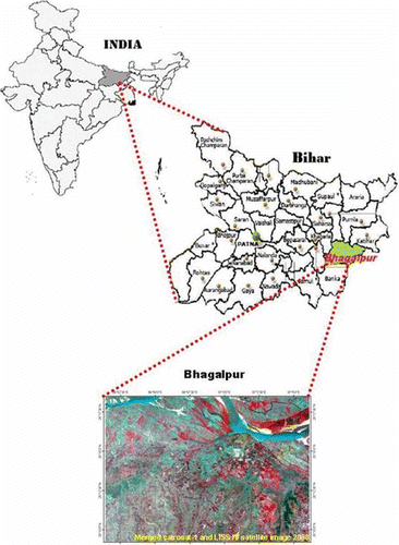
Bhagalpur is one of the oldest districts of Bihar (India), which is located in the plains of the Ganga river basin at a height of 42.97 m above the Mean Sea Level (MSL).The study area occupies an area of 434.40 km2 and its spatial extent lies between 25°09′ and 25°18′N, and 86°51′ and 87°07′E (as in ). The population of the district as per the 2001 census was 2.43 million and the density of the population was 946/km2. The study area is flood-prone, particularly the South Eastern and Middle Eastern part, during rainy seasons. The maximum temperature rises up to 44.5°C and the average rainfall is 1078 mm.
Figure 1. Location map of the study area.
Materials and methodology
The temporal satellite data of Landsat MSS, ETM+, and merged data of IRS-P6 LISS IV and Cartosat-1(IRS-P5) of 1976, 1999, and 2008, respectively, were used for the study. The Landsat satellite data were downloaded from the Global Land Cover Facility (GLCF) and IRS satellite data were taken from the National Urban Information System (NUIS) project (Department of Remote Sensing, BIT, Mesra, Ranchi, India). provides information about the satellite data used in the study. Ground truth data were collected in the month of November 2008 and January 2009 for visual interpretation and map generation with the help a Global Positioning System (GPS) in the form of latitude and longitude, which represent the accurate location. Census data from the Bhagalpur district were used for the assessment of the LCR and LAC. Data consisting of the population figures and decadal growth rate in the years 1971–2001 of the Bhagalpur area were taken from the NSWAI-ENVIS (National Solid Waste Association of India-Environmental Information System Node) bulletin (Anonymous Citation2004). The population of Bhagalpur in the years 1976, 1999, and 2008 was estimated by decadal growth rate data in the respective years (see and ).
Table 1. Data used for the study
Table 2. Decadal growth rate of the population of Bhagalpur from 1971 to 2001
Table 3. Population figures of Bhagalpur for the selected study years
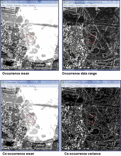
The overall methodology adopted for this research is summarised in . The methodology adopted in the current research describes the urban change dynamics, with areal extension and statistical methods for evaluating the LCR and LAC. The image segmentation approach was applied for texture analysis using the software ENVI® version 4.3 to extract the built-up features, which is shown in . Texture analysis is mainly based on structural and statistical approaches (Haralick Citation1979). Texture measures are related to the structural arrangements of surfaces and their connection to the surrounding environment as ‘an organised area phenomenon’ (Haralick Citation1979). The image segmentation approach classifies a given image into segments, that is, regions containing similar pixels. This helps in identifying the same objects for visual interpretation for classification of the satellite images into urban maps.
Figure 2. Methodology for urban dynamics change with temporal data.
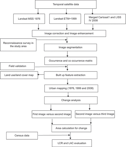
Figure 3. Image segmentation for urban area extraction using ENVI 4.3.
The section materials and methodology has been further divided into two sub-sections as follows:
| 1. | LULC mapping and urban change dynamics. | ||||
| 2. | LCR and LAC evaluation. | ||||
| 1. | LULC mapping and urban change dynamics | ||||
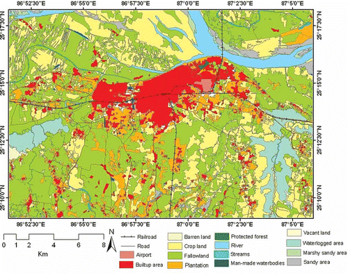
Figure 4. An LULC map of Bhagalpur city (Bihar, India).
The urban map polygon themes for the years 1976, 1999, and 2008, as prepared through the visual interpretation, were converted into a grid format using the Arc GIS and imported into ERDAS Imagine® as an image file for further analysis of the changed area. The urban maps of the respective® three years were overlaid using a matrix function in ERDAS Imagine to detect the changes. The change matrices were taken from the attributes of the overlaid images of 1976–1999 and 1999–2008. The approach seems relevant when providing change detection results.
(2) LCR and LAC evaluation
LCR is a measure of compactness, which indicates a progressive spatial expansion of a city. When the value of LCR is high it indicates crowdedness and if the value is low it indicates free spaces. Whereas LAC is a measure of changes in the consumption of new urban land by each unit increase in population. It indicates how new land is being used for built-up purposes and population is expanding outskirts or sprawl is taking place.
The formula for LCR and LAC is given below:
Where, A = Areal extent of the city in hectares
P = Population | |||||
Where, A1 and A2 = Areal extents (in hectares) for the early and later years, and
P1 and P2 = Population figure for the early and later years, respectively (Yeates and Garner Citation1976).
Results and discussion
The study reveals that the image segmentation approach applied for texture analysis shows better results than visual image interpretation to extract the built-up features. Data range and variance with a greater number of similar pixels with occurrence and co-occurrence matrix showing the best results for urban feature extraction with geospatial data (satellite image) are shown in . Image segmentation and visual interpretation analysis were applied to satellite imagery to map land use in Bhagalpur city. Accuracy for individual land use class was determined based on the error matrix generated in ERDAS Imagine (see ). Producer and user accuracies of 98.78% and 96.78%, respectively, for the built-up area were achieved during classification. Overall accuracy and kappa statistics of 89.36 and 0.84 were achieved in the study for land use cover.
Table 4. Error matrix for accuracy assessment
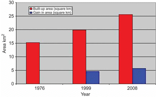
Urban maps prepared from satellite data for base years 1976, 1999, and 2008, respectively, are shown in –c. Result shows progressive growth of the spatial extant in the built-up area of the Bhagalpur urban region. The urban/built-up areas had a noticeable increase, from 3.512% (15.26 km2) of the total land in 1976 to 4.573% (19.866 km2) in 1999, and further increasing to 5.886% (25.886 km2) of the total land in 2008 as illustrated in and . The overall expansion of the built-up area was estimated 10.31 km2 from 1976 to 2008 and urban dynamic changes based on satellite data during the years 1976–1999 and 1999–2008 are shown in –f. Results show that the increase in the built-up area during the first time period (1976–1999) was 4.606 km2 and in the second time period (1999–2008) was 5.705 km2 where spatial pattern of development was 1.001% growth in 1999 and 1.313% growth in 2008 (see and ).
Table 5. Built-up area and other classes with the respective years
Table 6. Change statistics in the built-up area with time intervals
Figure 5. (a) Built-up area in the year 1976; (b) Built-up area in the year 1999; (c) Built-up area in the year 2008; (d) Extent during 1976 to 2008; (e) Extent during 1976–1999; (f) Changes in years 1999–2008.
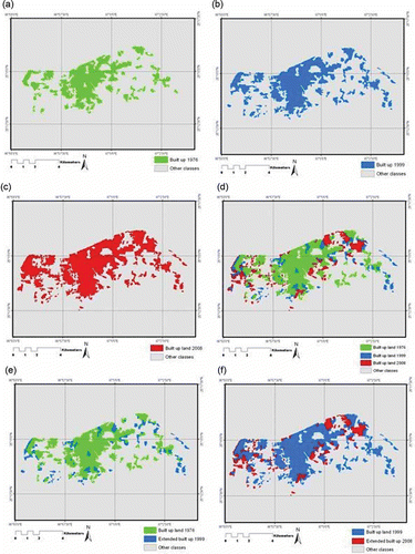
Figure 6. Built-up area and other classes with time periods.
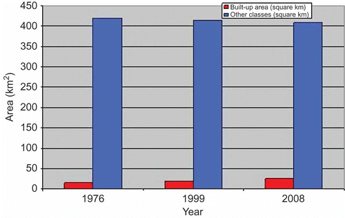
Figure 7. Built-up area gained over time periods.
The study reveals that the LCR for the years 1976, 1999, and 2008 is 0.001, 0.0008, and 0.00092, respectively. It was high till 1976, but decreased for the period 1976–1999 and slightly increased during 1999–2008 (see ). The study brings to light the trend of increasing LCR anticipated in the near future and indicates that the maximum urban area in this region was used during and before 1976 as LCR is very high as compared with that in the period 1999–2008. The current research shows that population growth and developmental activities are the main factors driving land use and expansion of built-up land in the outer area.
Table 7. LCR for the study periods
The findings of the study illustrate that the LAC for the periods 1976–1999 and 1999–2008 is 0.0005 and 0.001, respectively (see ). The LAC minimised during the period 1976–1999 and increased during 1999–2008. The result brings to light that during the period 1976–1999 the population was mostly concentrated within the city, but after 1999 people moved towards the outskirts of the city for better living in an open space away from the densely populated area. It is suggested that the rate at which new lands were acquired for built-up development is too high for Bhagalpur city. This situation will have negative implications in the urban region because of the associated problems of crowdedness and increased amount of solid waste management.
Table 8. LAC with time intervals
Land is consumed by the increasing population to provide for its needs, and land resources are continuously being used for developmental purposes for establishment of industries, commercial shops, and buildings. The land area is also required for dumping of solid wastes as the problem of solid waste disposal exists in the city of Bhagalpur. Thus, the increasing population requires land resources mostly for developmental purposes as well as for waste dumping sites. The population growth in Bhagalpur plays an important role in the environmental problems of the city: from cultivation to land degradation, increasing solid waste leads to nuisance, foul smell, and water pollution (the Ganga river), posing a threat to the rare dolphins (Platanista gangetica gangetica) in the Vikramshila Gangetic Dolphin Sanctuary. The growth of the city is restricted in the north direction due to the river Ganga; hence land utilization occurs from other directions resulting in a high LCR.
This study is mainly focused on a higher level scientific approach using geospatial image differencing techniques for assessing urban dynamics with a temporal data set and calculations for LCR and LAC evaluation of the region from the past to the present time point. It can be used for the assessment and estimation of the future population pressure on the land demands for various developmental activities for a particular area of interest. It is inferred that the changes have been taking place in the study area in the form of urban sprawl in the outskirts of the city; the changes and expansion are mostly in the southward direction and restricted to the northward direction due to a natural barrier (the Ganga river).
Our objective is to determine the LCR and LAC with urban change dynamics using satellite remote sensing data. The geospatial techniques provide an accurate, cost-effective, and spatial dynamics of the land cover from various time periods for performing these estimations on a regional or global basis as compared with the conventional study. Along with ground truth and field inventory, the study methodology will be useful in understanding the land use development, future planning, and proper management.
Related Research Data
References
- Anonymous (1996). Economic and Social Commission for Asia and the Pacific, United Nations (ESCAP). Introduction to India, India Country Report, Infrastructure Programme, September 1996 http://www.unescap.org/ttdw/common/TPT/ReviewofPlanning/CountryPapers/India.pdf (http://www.unescap.org/ttdw/common/TPT/ReviewofPlanning/CountryPapers/India.pdf)
- Anonymous . 2004 . “ National Solid Waste Association of India-Environmental Information System Node ” . In Urban Municipal Solid Waste Management 1 – 8 . 2 (Feb)
- Berberoglu , S. and Akin , A. 2009 . Assessing Different Remote Sensing Techniques to Detect Land Use/Cover Changes in the Eastern Mediterranean . International Journal of Applied Earth Observation and Geoinformation , 11 : 46 – 53 .
- Daniel , L.C. , Hurd , J. , Wilson , E.H. , Song , M. and Zhang , Z. A Comparison of Land Use and Land Cover Change Detection Methods . ASPRS-ACSM Annual Conference and FIG XXII Congress . pp. 2
- Dimyati , M. , Mizumo , K. , Kobayashi , S. and Kitamura , T. 1995 . An Analysis of Land Use/Land Cover Change Using the Combination of MSS Landsat and Land Use Map-a Case Study of Yogyakarta, Indonesia . International Journal of Remote Sensing , 17 ( 5 ) : 931 – 944 .
- Yu , Haiying . 2007 . Land Use/Land Change and Environmental Vulnerability Analysis in Birahi Ganga Sub-Watershed of the Garhwal Himalaya, India . Journal of Tropical Ecology , 48 ( 2 ) : 241 – 250 .
- Haralick , R.M. 1979 . Statistical and Structural Approaches to Texture . Proceedings of the IEEE , 67 : 786 – 804 .
- Lu , D.S. , Mausel , P. , Brondı´zio , E.S. and Moran , E. 2004 . Change Detection Techniques . International Journal of Remote Sensing , 25 : 2365 – 2407 .
- Macleod , R.D. and Congalton , R.G. 1998 . A Quantitative Comparison of Change Detection Algorithms for Monitoring Eelgrass From Remotely Sensed Data . Photogrammetric Engineering & Remote Sensing , 64 ( 3 ) : 207 – 216 .
- Ojima , D.S. , Glavin , K.A. and Turner , B.L. II . 1994 . The Global Impact of Land-Use Change . Bioscience , 44 ( 5 ) : 300 – 304 .
- Parés-Ramos, I.K., Gould, W.A., and Mitchell, A.T. (2008), “Agricultural Abandonment, Suburban Growth, and Forest Expansion in Puerto Rico Between 1991 and 2000,” Ecology and Society, 13(2), 1. http://www.ecologyandsociety.org/vol13/iss2/art1/ (http://www.ecologyandsociety.org/vol13/iss2/art1/)
- Singh , A. 1989 . Digital Change Detection Techniques Using Remotely Sensed Data . International Journal of Remote Sensing , 10 ( 6 ) : 989 – 1003 .
- Yeates , M. and Garner , B. 1976 . The North American City , New York : Harper and Row Publication .
- Zubair , A.O. 2006 . “Change Detection in Land Use and Land Cover Using Remote Sensing Data and GIS (A Case Study of Ilorin and its Environs in Kwara State), Msc Thesis, Nigeria: University of Ibadan