Abstract
Urban sprawl is one of the main problems that threaten the limited highly fertile land in the Nile Delta of Egypt. In this research, satellite images of Landsat Thematic Mapper (TM) 1992, Landsat Enhanced Thematic Mapper (ETM+) 2001 and Egypt Sat-1 2009 have been used to study the urban sprawl and its impact on agricultural land in Qalubiya Governorate. Maximum likelihood supervised classification and post-classification change detection techniques were applied for monitoring the urban sprawl in this study area. Ground truth collected during several field trips conducted in 2009 and a topographic map from 1992 were used to assess the accuracy of the classification results. Using ancillary data, visual interpretation and expert knowledge of this area through GIS further refined the classification results. Post-classification change detection technique was used to produce change image through cross-tabulation. Combining the soil and land capability maps, on one hand, and the urban thematic layers, on the other hand, using GIS, made it possible to point out the risk of urban expansion on the expense of the highly capability class. During the (1992–2009) period, the high capable soils (Class I) decreased from 683.2 km2 to 618.5 km2. The moderate capable soils decreased from 100.5 km2 to 93.8 km2 whereas the marginally capable soils decreased from 209.1 km2 to 198.3 km2, during the same period. The urban encroachment over the non-capable soils was very limited during the 1992–2001 period. The pattern of urban sprawl changed during the 2001–2009 period whereas most of the urban expansion was on the expense of the non-capable soils.
1. Introduction
Food scarcity and continuous loss of agricultural lands are issues of global concern. The government of Egypt adopted policies aimed at self-sufficiency in food production, for example, extension of cultivated areas and maximization of production of the existing agricultural land. The principal purpose is to control Egypt's predominating unfavourable population to agricultural land ratio. Urbanization is an inevitable process due to economic development and rapid population growth. Encroachment of urban settlements on agricultural lands may pose dire consequences. The continuous increase in population density causes increasing pressure on areas already inhabited and caused a decrease in area per capita from 0.12 ha in 1950 to 0.06 ha in 1990 (Suliman Citation1991) and 0.04 ha in 2009 (CAPMAS Citation2009). Desert and uninhabited lands represent about 95% of the total area of Egypt. However, the majority of the population is concentrated around the River Nile. This unbalanced distribution causes serious social and economical problems. Since 1980s, the Egyptian government started plans to adjust this situation by redistributing the population growth through applying an effective horizontal urban expansion along the desert areas and near the fringes of the Nile Delta. This policy aims at reducing the pressure on the old and highly productive agricultural land, decreasing population density in the inhabited areas and decreasing pollution sources by establishing industrial areas outside the Nile valley and delta. Therefore, determining the trend and the rate of land cover conversion is necessary for the development planner to establish rational land use policy (Shalaby and Tateishi Citation2007). For this purpose, the temporal dynamics of remote sensing data can play an important role in monitoring and analysing land cover changes. Accurate and up-to-date land cover change information is necessary to understand both human causes and environmental consequences of such changes (Aboel Ghar, Shalaby, and Ryutaro Citation2004). As a consequence, information about land use/land cover is essential for any kind of natural resource management and action planning. Opportune and accurate information about land use/land cover changes of an area is essential for understanding the interactions between human and natural resources for better decision-making (Lu, Mausel, Brondizio, and Morean Citation2004). There is a continuing demand for accurate and up-to-date land use/land cover information for any kind of sustainable development program where land use/land cover serves as one of the major input criteria. As a result, the importance of properly mapping land use/land cover and its change as well as updating it through time has been acknowledged by various research workers for decision-making activities, as, for example, application of land cover change in urban environment by Deng, Wang, Li, Feng, and Huang (Citation2005). Urban sprawl causes loss of agricultural land, which results in substantial changes in agricultural ecosystems. Monitoring these changes and planning urban development can be achieved using multi-temporal remotely sensed data, spatial metrics and modelling (Yikalo and Pedro Citation2010). Change detection is the process of determining and/or describing changes in land cover and land use properties based on co-registered multi-temporal remote sensing data. The basic premise in using remote sensing data for change detection is that the process can identify change between two or more dates that is uncharacteristic of normal variation. Numerous researchers have addressed the problem of accurately monitoring land cover and land use change in a wide variety of environments (e.g. Singh Citation1989; Muchoney and Haack Citation1994; Shalaby and Tateishi Citation2007; Almutairi and Warner Citation2010). Many studies have discussed land cover and land use changes in arid and semi-arid regions (e.g. Ram and Kolarkar Citation1993; Sadek Citation1993; Lenney, Woodcock, Collins, and Hamdi Citation1996; Lambin and Ehrlich Citation1997; Rembold, Carnicelli, Nori, and Ferrari Citation2000; Mendoza and Etter Citation2002); these studies showed that urban expansion usually occurs through the deduction of agricultural land. There are many techniques available to detect and record differences (e.g. image differencing, ratios or correlation) and these might be applicable to changes in land cover (Singh Citation1989; Stow, Chen, and Parrott Citation1996; Yuan, Elvidge, and Lunetta Citation1999; Maldonado, dos Santos, and de Carvalho Citation2002; Li and Yeh Citation2004; Deng, Wang, Deng, and Qi Citation2008). However, the simple detection of change is rarely sufficient in itself: information is generally required about the initial and final land cover or types or land uses, the ‘from–to’ analysis (Khorram et al. Citation1999). Furthermore, the detection of image differences may be confused with problems in phenology and cropping, and such problems may be exacerbated by limited image availability and poor quality in temperate zones and difficulties in calibrating poor images. Post-classification comparisons of derived thematic maps go beyond simple change detection and attempt to quantify the different types of change. The degree of success depends upon the reliability of the maps made by image classification. Broadly speaking, large-scale changes such as widespread logging or major urban development might be mapped easily. Whereas with evolutionary changes such as erosion, succession, colonization or degradation, the boundaries may be indistinct and the class labels uncertain (Foody and Boyd Citation1999; Khorram et al. Citation1999; Shalaby and Tateishi Citation2007).
The objectives of this study are to investigate the urban sprawl rate and its impact on agricultural land through integrating remote sensing and GIS.
2. Study area
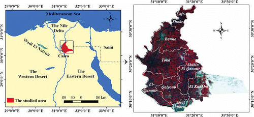
The Qalubiya Governorate is located on the eastern side of the River Nile, near the delta head between 30°06′11″ and 30°36′36″ North and 31°03′20″ and 31°35′32″ East (). The governorate is characterized by a specific location as it is considered the meeting point of the main transport lines between northern governorates. The total area of the governorate is estimated to be 1140.52 km2, of which the cultivated area is 810 km2, representing 71% of its total coverage. The Qalubiya Governorate includes eight districts. The common activity in the governorate is mostly agriculture, in addition to the existence of some industrial parks. The climatic data from the Qalubiya Governorate indicate that the total rainfall does not exceed 7.2 mm/year and the mean minimum and maximum annual temperatures are 16.5°C and 31.0°C, respectively. The evaporation rates coincide with temperatures, where the lowest evaporation rate (1.9 mm/day) was recorded in January, and the highest value (7.6 mm/day) was recorded in June (EMA Citation1996). According to the aridity index classes (Hulme and March Citation1990), the Qalubiya Governorate is located under arid climatic conditions.
Figure 1. Location map of Qalubiya Governorate on Egypt map (left), Landsat ETM+ image of Qalubiya Governorate (FCC, 4, 3, 2) to the right.
3. Materials and methods
The materials used in this research are
| 1. | Landsat Thematic Mapper (TM) images (path 176/row 39) acquired on 7 May 1992. | ||||
| 2. | Landsat Enhanced Thematic Mapper (ETM+) acquired on 29 May 2001. | ||||
| 3. | Two scenes of Egypt Sat-1 dated 7 and 15 July 2009. The specifications of Landsat and Egypt Sat-1 images are illustrated in . Table 1. Specification of Landsat TM and Egypt Sat-1 images | ||||
| 4. | Soil map of Egypt (1982) scale 1:100,000 and topographic maps (1992) scale 1:50,000. | ||||
3.1. Geometric correction
Accurate per-pixel registration of multi-temporal satellite data is essential for change detection because registration errors could be inferred as land use/cover changes, leading to an overestimation of actual change (Stow Citation1999). Change detection analysis is performed on a pixel-by-pixel basis; therefore any misregistration greater than one pixel will provide an anomalous result for that pixel. To overcome this problem, the root mean square error (RMSE) between any two dates should not exceed 0.5 pixel (Lunetta and Elvidge Citation1998). In this study, geometric correction was carried out using ground control points from digital topographic maps (UTM, WGS84) to geocode the image of 1992, then this image was used to register all the other images; the RMSE between different images was less that 0.4 pixel, which is acceptable.
3.2. Image enhancement and visual interpretation
The goal of image enhancement is to improve the visual interpretability of an image by increasing the apparent distinction between the features. The process of visually interpreting digitally enhanced imagery attempts to optimize the complementary abilities of the human mind and the computer. The mind is excellent at interpreting spatial attributes on an image and is capable of identifying obscure or subtle features (Lillesand and Kiefer Citation1994). Contrast stretching was applied on all images and the false colour composites (FCC) were produced. These FCC are visually interpreted using on-screen digitizing to delineate land cover classes that could be easily interpreted, such as urban and water.
3.3. Image classification
Land cover classes are typically mapped from digital remotely sensed data through the process of a supervised digital image classification (Campbell Citation1987; Thomas, Benning, and Ching Citation1987). The overall objective of the image classification procedure is to automatically categorize all pixels in an image into land cover classes or themes (Lillesand and Kiefer Citation1994). The maximum likelihood classifier quantitatively evaluates both the variance and covariance of the category spectral response patterns when classifying an unknown pixel so that it is considered to be one of the most accurate classifiers, as it is based on statistical parameters. Supervised classification was done using ENVI 4.7 software depending on the ground checkpoints and the digital topographic maps of the study area. Then accuracy assessment was carried out using 300 points from field data and existing land cover maps. To increase the accuracy of urban land cover class, ancillary data and the result of visual interpretation were integrated with the classification result using GIS.
3.4. Urban sprawl detection
Regardless of the technique used, the success of change detection from imagery will depend on both the nature of the change involved and the success of the image preprocessing and the classification procedures. If the nature of the change within a particular scene is either abrupt or at a scale appropriate to the imagery collected then change should be relatively easy to detect; problems occur only if spatial change is subtly distributed and hence not obvious within any image pixel (Milne Citation1988). In the case of the study area chosen, field observation and measurements have showed that the change in land cover between the three dates was both marked and abrupt. In this study post-classification change detection technique was applied. Post-classification is the most obvious method of change detection, which requires the comparison of independently produced classified images. Post-classification comparison proved to be the most effective technique, because data from two dates are separately classified, thereby minimizing the problem of normalizing for atmospheric and sensor differences between different dates. Urban land cover class was extracted from the classified images, and then cross-tabulation analysis was carried out to study the spatial distribution and areas of urban sprawl (of 1992, 2001 and 2009) on different soil types, ArcGIS 9.2 software was used for this function.
3.5. Digital soil mapping and land capability
The soil map of the study area was extracted from the available soil map of Egypt produced by the Academy of Scientific Research and Technology (ASRT Citation1982); the original nomenclature of soil order, suborders and great groups has been updated according to the latest American Soil Taxonomy of USDA (Citation2010). The transformation of the soil map (produced in 1982) into a digital format was done. The study area is covered by two soil map sheets. These sheets were scanned and geometrically corrected using UTM coordinate system and WGS84 projection. On-screen digitizing was used to convert the two sheets into vector formats and then edge matching was performed using ArcGIS 9.2. It was noticed, after edge matching, that there was a deviation (constant in many places in its direction and magnitude) between the produced map and the well-registered landmarks, driven out of the survey maps and satellite images of the study area. After investigating this deviation, it has been attributed to two reasons: lack of a coordinate and the rubber-sheeting that accompanied the edge-matching task (Boullie Citation1978). To overcome this problem another spatial adjustment (transformation) has been performed. Well-registered topographic maps and accurately geo-referenced satellite images have been used to perform the transformation process. The transformation tools of ArcGIS 9.2 system were found to be effective in performing the spatial adjustment of the thematic map (Burrough Citation1986). A semi-detailed survey was done throughout the investigated area to gain an appreciation on the soil patterns, the land forms and landscape characteristics. The laboratory analysis of the study area reported by ASRT (Citation1982) has been compiled in the database and incorporated into the attribute table of the soil map (Pavasovic Citation1993; Nguyen Citation2001). The land capability classes were obtained using soil data following the methodology of FAO (Citation1985). Urban land cover class was extracted from the classified images and overlaid on the soil capability map, then the areas lost from different land capability classes due to urban sprawl were calculated.
4. Results and discussion
The soil map of Qalubiya Governorate demonstrates that only four sub-great groups are present in the whole area. The Vertic Torrifluvents sub-great group dominates the soil types, covering an area of 616.37 km2 (54% of the governorate). The Typic Torrifluvents sub-great group covers limited patches within the alluvial landscape, exhibiting 90.48 km2 (7.9%). The Typic Quartzipsamments sub-great group covers an area of 119.99 km2 (10.52%) found at the south-eastern borders of the Governorate, adjacent to the mountains and hills area. It also interferes with the sub-great group Typic Torriorthents, which exists in limited patches having a total area of 30.63 km2 (2.69%).
The visual interpretation gave a general idea about the forms of land cover changes over the period. Many urban areas were erected recently, especially near Cairo, at the expense of the most fertile soils. This overlaying of the visual interpretation on the result of the classification led to the increase in the overall accuracies by about 10%. A standard overall accuracy for land cover and land use maps is set between 85% (Anderson, Hardy, Roach, and Witmer Citation1976) and 90% (Lins and Kleckner Citation1996). In this study the overall classification accuracy was found to be 91% for 1992, 92.3% for 2001 and 90.4% for 2009. The differences in the accuracies of the classification of the three different images could be attributed to the specification of Landsat (TM and ETM+) and Egypt Sat-1 whereas Egypt Sat-1 has the lowest spectral resolution.
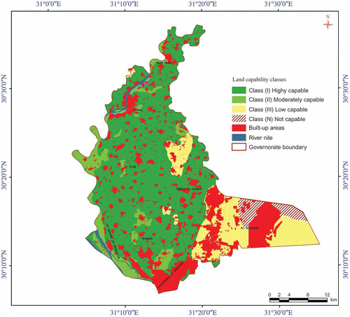
The urban areas are overlaid on top of the soil capability map to show the extent of urban on the expense of agricultural land ().
Figure 2. Urban settlements, extracted from TM image of 1992, overlaid on soil capability map.
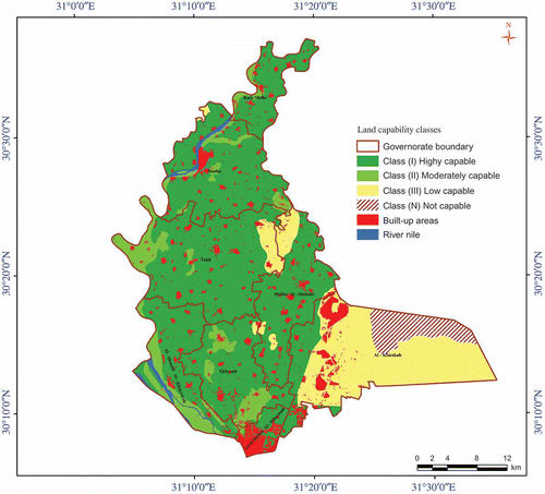
Figure 3. Urban settlements, extracted from ETM+ image of 2001, overlaid on soil capability map.
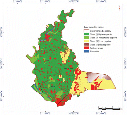
Figure 4. Urban settlements, extracted from Egypt Sat-1 image of 2009, overlaid on soil capability map.
Remote sensing data and GIS provide opportunities for integrated analysis of spatial data. Cross-tabulation performs image cross-tabulation in which the categories of one image are compared with those of a second image and tabulation is kept of the number of cells in each combination.
Urban sprawl between 1992 and 2009 was mapped and overlaid on the soil map of the study area (). The statistical data about the spatial urban changes from 1992 to 2009 are illustrated in and .
Figure 5. Urban settlements in 1992, 2001 and 2009.
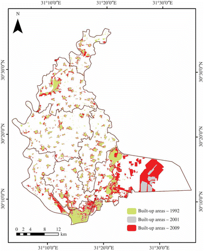
Figure 6. Trends of soil types and built-up areas changes.
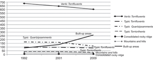
Table 2. Urban settlement changes of Qalubiya Governorate from 1992 to 2009, areas in km2
Change detection technique resulted in following the evolution of urban areas and its implication on soil and land capability units. The built-up areas in the governorate increased from 89.96 km2 in the year 1992 to 124.54 km2 in 2001 and to 241.86 km2 in the year 2009. During the study period the total urban area increased by 151.9 with a rate of 8.9 km2 per year (i.e. 10%).
In terms of land capability classification, the high capable soils (Class I) decreased from 683.12 km2 in 1992 to 665.35 km2 in 2001 and to 616.37 km2 in 2009. The moderate capable soils decreased from 100.45 km2 to 90.48 km2 from 1992 to 2009 whereas the marginally capable soils decreased from 209.07 km2 to 150.62 km2 during the same period. It is noticed that urban encroachment over the non-capable soils is very limited, as their coverage was found to be stable during the period 1992–2001 (i.e. 0.36 km2).
Urbanization had spread in the whole governorate especially near Cairo (i.e. Shoubra El-Khiema and El-Khanka districts). In these two districts, during the period 1992–2001, the total urban expansion was estimated to be 21.47 km2, with most of this expansion being at the expense of the most fertile soil (Vertic Torrifluvents) of which 6.48 km2 (13.68%) was converted to urban settlement. The less fertile soils such as Typic Torrifluvents and Typic Quartzipsamments lost only 11.55 km2 (8.56%) of these two classes due to urban sprawl. Between 2001 and 2009, the total urban expansion was 68.88 km2 whereas Vertic Torrifluvents soils lost 11.06 km2 representing 37.11% loss of this soil type to urbanization. The pattern of urban sprawl has changed during this period whereas most of the urban expansion was at the expense of the less fertile soils Typic Torrifluvents, Typic Quartzipsamments and Typic Torriorthents. A total of 42.05 km2 (26.07%) of these three soil types was converted to urban in addition to 15.76 km2 of consolidated rocky ridge and mountains and hills. Details of urban sprawl over different soil types in these two districts are shown in . These changes on the less fertile soils could be explained by the fact that during the period from 2001 to 2009 a new residential and industrial city called Al Obour City was constructed on the southeast of the study area. The latest urban expansion between 2001 and 2009 is planned as contrary to the urban sprawl between 1992 and 2001. The existence of a law that forbids the construction on agricultural land did not prevent the unplanned urban invasion over the fertile land. This kind of unplanned urban expansion has severe consequences causing many social and health problems. This is caused by inappropriate infrastructure including roads and sewage systems as well as clean water unavailability.
Table 3. Urban settlement changes of Shoubra El-Khiema and El-Khanka districts from 1992 to 2009, areas in km2
Fragmentation and dispersal of the agricultural land is a major characteristic of Egyptian agriculture. Fragmentation indicates a small size of the production unit. Dispersal means the distribution of a holding into scattered plots within the same village or in other villages within the same district. Kruseman and Vullings (Citation2007) reported that more than 80% of the landholdings in Egypt are currently less than six acres; it is expected to be less than four acres by 2025. Fragmentation and dispersal of landholdings are caused by overpopulation and the system of inheritance with a relatively constant area of the agricultural land and these lead to a sequential partition of the land. The fragmentation and dispersal of the agricultural landholding have a negative impact on the rate of growth in the agricultural sector. This is evidenced by the difficulty in implementing modern agricultural techniques, the high cost of agronomic practices and the low efficiency of agricultural labour (Farah Citation1967). Therefore, the fragmentation led to the loss in the cultivable land due to the fact that a part of it is used for building, irrigation, drainage and passages around and inside small holdings. The land fragmentation affects the land ownership where there is a loss of about 20% of land use in irrigation canals and partition between the farms (Kruseman and Vullings Citation2007). The fragmentation of farm size reduces the potential financial returns and increases the value of land for non-agriculture purposes.
The establishment of industrial zones near the agricultural areas has led to conversion of smallholders to urban areas, which is very clear in Shoubra El-Khiema and El-Khanka districts.
The population of Qalubiya Governorate increased from 3,301,244 to 4,536,800 inhabitants between 1996 and 2009 at an annual rate of 95,042 inhabitants per year (CAPMAS Citation2009). The total loss in arable land between 1992 and 2009 was 151.3 km2 due to urbanization, that is, with a rate of 8.9 km2 per year. With this rate of population growth it is expected that the population of the governorate will reach 8,433,554 by the year 2050, consequently urban expansion may increase by about 346.9 km2. To overcome this serious problem, the rate of population growth must be decreased and new urban areas must be established in the eastern desert to accommodate the expected population growth.
5. Conclusion
The objective of this study was to study the urban sprawl and its impact on agricultural land in Qalubiya. It was found that integrating visual interpretation with supervised classification led to increase in the overall accuracy by 10%. The study area has undergone a very severe land cover change as a result of urbanization resulting from rapid population growth. A considerable increase in urban settlements has taken place at the expense of the most fertile land in the Governorate. Integrating GIS and remote sensing provided valuable information on the nature of land cover changes, especially the area and spatial distribution of different land cover changes.
The main causes of urbanization are the rapid population growth and the internal migration. This problem needs to be seriously studied, through multidimensional fields including socioeconomic, to preserve the precious and limited agricultural land and increase food production.
References
- Aboel Ghar , M. , Shalaby , A. and Ryutaro , T. 2004 . Agricultural Land Monitoring in the Egyptian Nile Delta Using Landsat Data . International Journal of Environmental Studies , 1 ( 6 ) : 651 – 657 .
- Almutairi , A. and Warner , A.T. 2010 . Change Detection Accuracy and Image Properties: A Study Using Simulated Data . Remote Sensing , 2 : 1508 – 1529 .
- Anderson , J.R. , Hardy , E.E. , Roach , J.T. and Witmer , R.E. 1976 . “A Land-Use and Land Cover Classification System for Use with Remote Sensor Data,” US Geological Survey Professional Paper 964 Washington , DC
- ASRT . 1982 . “Soil Map of Egypt,” Final Report , Cairo , , Egypt : Academy of Scientific Research and Technology (ASRT) .
- Boullie , F. 1978 . “ Structuring Cartographic Data and Spatial Processes with the Hypergraph-Based Data Structure ” . In First International Advanced Study Symposium on Topological Data Structures for Geographic Information Systems , Edited by: Dutton , G. Vol. 5 , Harvard, MA : Laboratory for Computer Graphics and Spatial Analysis .
- Burrough , P.A. 1986 . Principals of Geographic Information Systems for Land Resources Assessment , Oxford : Clarendon .
- Campbell , J.B. 1987 . Introduction to Remote Sensing , New York : The Guilford Press .
- CAPMAS . 2009 . “Statistical Year Book,” Annual Report July 2009 , Cairo , , Egypt : Central Agency for Public Mobilization and Statistics (CAPMAS) .
- Deng , J.S. , Wang , K. , Deng , Y.H. and Qi , G.J. 2008 . PCA-Based Land-Use Change Detection and Analysis Using Multitemporal and Multisensor Satellite Data . International Journal of Remote Sensing , 29 ( 16 ) : 4823 – 4838 .
- Deng , J.S. , Wang , K. , Li , J. , Feng , X. and Huang , J. Integration of SPOT-5 and ETM+ Images to Detect Land Cover Change in Urban Environment . IEEE International Geoscience and Remote Sensing Symposium . July 25–29 , Seoul , South Korea.
- EMA . 1996 . “Climatic Atlas of Egypt,” Published Report , Cairo , , Egypt : Egyptian Meteorological Authority (EMA) .
- FAO . 1985 . “Land Evaluation for Irrigated Agriculture,” Soils Bulletin 55 , Rome : FAO .
- Farah , A.F. 1967 . “Fragmentation in the Egyptian Farms: Dimensions of the Problem and Planning for Remedy,” Internal Memorandum No. 794 , Cairo , , Egypt : The National Planning Institute (NPI) .
- Foody , G.M. and Boyd , D.S. 1999 . Detection of Partial Land Cover Change Associated with the Migration of Inner-Class Transitional Zones . International Journal of Remote Sensing , 20 : 2723 – 2740 .
- Hulme , M. and March , R. 1990 . “Global Mean Monthly Humidity Surfaces for 1930–59, 1960–89 and Projected for 2020,” UNEP/GEMS/GRID , Norwich , , Norfolk : Climatic Research Unit, University of East Anglia .
- Khorram , S. , Biging , G.S. , Chrisman , N.R. , Congalton , R.G. , Dobson , J.E. , Ferguson , R.L. , Goodchild , M.F. , Jensen , J.R. and Mace , T.H. 1999 . Accuracy Assessment of Remote Sensing-Derived Change Detection , 64p Bethesda , MD : American Society of Photogrammetry and Remote Sensing .
- Kruseman , G. and Vullings , W. “Rural Development Policy in Egypt Towards 2025; Targeted Conditional Income Support: A Suitable Option?,” . Alerra Report 1526 170 blz, Wageningen: Alterra . 2007 .
- Lambin , E.F. and Ehrlich , D. 1997 . Land-Cover Changes in Sub-Saharan Africa (1982–1991): Application of a Change Index Based on Remotely Sensed Surface Temperature and Vegetation Indices at a Continental Scale . Remote Sensing of Environment , 61 ( 2 ) : 181 – 200 .
- Lenney , M.P. , Woodcock , C.E. , Collins , J.B. and Hamdi , H. 1996 . The Status of Agricultural Lands in Egypt: The Use of Multi Temporal NDVI Features Derived From Landsat TM . Remote Sensing of Environment , 56 : 8 – 20 .
- Li , X. and Yeh , A. 2004 . Analyzing Spatial Restructuring of Land Use Patterns in a Fast Growing Region Using Remote Sensing and GIS . Landscape and Urban Planning , 69 ( 4 ) : 335 – 354 .
- Lillesand , T.M. and Kiefer , R.W. 1994 . Remote Sensing and Image Interpretation , 4th , New York : John Wiley and Sons .
- Lins , K.S. and Kleckner , R.L. 1996 . “ Land Cover Mapping: An Overview and History of the Concepts ” . In Gap Analysis: A Landscape Approach to Biodiversity Planning , Edited by: Scott , J.M. , Tear , T.H. and Davis , F. 57 – 65 . Bethesda , MD : American Society for Photogrammetry and Remote Sensing .
- Lu , D. , Mausel , P. , Brondizio , E. and Morean , E. 2004 . Change Detection Techniques . International Journal of Remote Sensing , 25 ( 12 ) : 2365 – 2407 .
- Lunetta , R.S. and Elvidge , C.D. 1998 . Remote Sensing Change Detection , 123 – 135 . Ann Arbor , MI : Ann Arbor Press . Chapter 7
- Maldonado , F.D. , dos Santos , J.R. and de Carvalho , V.C. 2002 . Land Use Dynamics in the Semi-Arid Region of Brazil (Quixaba, PE): Characterization by Principal Component Analysis (PCA) . International Journal of Remote Sensing , 23 ( 23 ) : 5005 – 5013 .
- Mendoza , J.E. and Etter , R. 2002 . Multitemporal Analysis (1940–1996) of Land Cover Changes in the Southwestern Bogota Highplain (Colombia) . Landscape and Urban Planning , 59 ( 3 ) : 147 – 158 .
- Milne , A.K. Change Detection Analysis Using Landsat Imagery a Review of Methodology . Proceedings of IGARSS 88 Symposiums . September 13–16 1988 , Edinburgh , Scotland. pp. 541 – 544 .
- Muchoney , D.M. and Haack , B. 1994 . Change Detection for Monitoring Forest Defoliation . Photogrammetric Engineering and Remote Sensing , 60 : 1243 – 1251 .
- Nguyen , Q.D. 2001 . “Cave Database Development, Spatial Analysis and 3D Visualization with GIS – Case Study in Son La (Vietnam),” VU Brussels Unpublished master dissertation
- Pavasovic , K. 1993 . “Land Suitability Models,” Workshop on Geographical Information Systems in Integrated Coastal Management Alexandria , , Egypt
- Ram , B. and Kolarkar , A.S. 1993 . Remote Sensing Application in Monitoring Land-Use Changes in Arid Rajasthan . International Journal of Remote Sensing , 14 ( 17 ) : 3191 – 3220 .
- Rembold , F. , Carnicelli , S. , Nori , M. and Ferrari , A. 2000 . Use of Aerial Photographs, Landsat TM Imagery and Multidisciplinary Field Survey for Land-Cover Change Analysis in the Lakes Region (Ethiopia) . International Journal of Applied Earth Observation and Geoinformation , 2 ( 3–4 ) : 181 – 189 .
- Sadek , S.H.A. 1993 . Use of Landsat Imagery for Monitoring Agricultural Expansion of East and West Nile Delta, Egypt . Egyptian Journal of Soil Science , 33 ( 1 ) : 23 – 24 .
- Shalaby , A. and Tateishi , R. 2007 . Remote Sensing and GIS for Mapping and Monitoring Land Cover and Land-Use Changes in the Northwestern Coastal Zone of Egypt . Applied Geography , 27 ( 2007 ) : 28 – 41 .
- Singh , A. 1989 . Digital Change Detection Techniques Using Remotely Sensed Data . International Journal of Remote Sensing , 10 : 989 – 1003 .
- Stow , D.A. 1999 . Reducing Mis-Registration Effects for Pixel-Level Analysis of Land-Cover Change . International Journal of Remote Sensing , 20 : 2477 – 2483 .
- Stow , D.A. , Chen , D.M. and Parrott , R. 1996 . “ Enhancement, Identification and Quantification of Land Cover Change ” . In Raster Imagery in Geographical Information Systems , Edited by: Morain , S.A. and Lopez Barose , S.V. 307 – 312 . Santa Fe , NM : One Word .
- Suliman , M.K. Universities and Development of the Desert land in the ARE . The Second Annual University Conference . November 2–5 , Cairo , Egypt.
- Thomas , I.L. , Benning , V.M. and Ching , N.P. 1987 . Classification of Remotely Sensed Images , Bristol : Adam Hilger .
- USDA . 2010 . Keys to Soil Taxonomy , 11th , Washington , DC : United State Department of Agriculture, Natural Resources Conservation Service (NRCS) .
- Yikalo , H.A. and Pedro , C. 2010 . Analysis and Modeling of Urban Land Cover Change in Setúbal and Sesimbra, Portugal . Remote Sensing , 2 : 1549 – 1563 .
- Yuan , D. , Elvidge , C.D. and Lunetta , R.S. 1999 . “ Survey of Multi-Spectral Methods for Land Cover Change Analysis ” . In Remote Sensing Change Detection: Environmental Monitoring Methods and Applications , Edited by: Lunetta , R.S. and Elvidge , C.D. 21 – 39 . London : Taylor & Francis .