
Abstract
Land-use and land-cover change has been a topic that has called the attention of the scientific community for decades. Because of the importance of tropical and subtropical forest ecosystems, investigations into the causes and processes (e.g., underlying and proximate causation) that drive land use and land-cover change have typically concentrated on these regions. Consequently, little work has been done to understand the proximate and underlying drivers of land use and land-cover change in one of the least disturbed forests worldwide, the Paraguayan dry Chaco in South America. This article attempts to fill this gap in the literature by focusing on the processes and drivers behind land-cover change in the Paraguayan Chaco. More specifically, this article links underlying and proximate causes to regional land-cover change. To accomplish this task the study makes use of Moderate Resolution Imaging Spectroradiometer (MODIS) data and census data. Results show major land-cover changes. Different from other dry regions in South America where soybean expansion has been pointed out as main driver of land-cover change, in the Paraguayan Chaco, cattle ranching is a major driver of forest loss.
1. Introduction
Land-use and land-cover (LULC) dynamics are producing changes that impact humans (Agarwal, Green, Grove, Evans, & Schweik, Citation2002). LULC alters the availability of different biophysical resources including soil and water quality, among other important resources. These changes affect the production of environmental services (most notably agricultural production) and damage the ecosystem. Concerns over LULC changes have become more serious in the past few decades because of mounting forest loss, especially in tropical and subtropical regions. Forests are especially significant, because they act as a reservoir of biodiversity and as a carbon sink. Both of these ecosystem roles are threatened by what appears to be an inexorable process of forest destruction (Achard et al., Citation2002). These concerns have spawned a great deal of research recognizing that LULC change is one of the global drivers of ecosystem degradation (Lambin, Geist, & Lepers, Citation2003; Sala et al., Citation2000; Turner, Citation2002).
Because of the importance of tropical and subtropical forest ecosystems, investigations into the causes and processes that drive forest loss have typically concentrated on these regions. Since the beginning of the 1980s, many attempts have been made to explain tropical and subtropical deforestation throughout the world (e.g., Aldrich, Walker, Simmons, Caldas, & Perz, Citation2012; Allen & Barnes, Citation1985; Angelsen & Kaimowitz, Citation1999; Arima, Richards, Walker, & Caldas, Citation2011; Brown & Pearce, Citation1994; Caldas et al., Citation2007, 2010); Geist, Kant, & Redantz, Citation1997; Irwin & Geoghegan, Citation2001; Lambin, Citation2001, 2002); Lambin et al., Citation2001, Citation2003; Rudel & Roper, Citation1996, Citation1997; Southgate, Sierra, & Brown, Citation1991; Stern, Young, & Druckman, Citation1992; Tucker & Richards, Citation1983; Wunder, Citation2000). These studies represent a comprehensive account of the subject and have produced many arguments about what drives land-cover change. For instance, the recent literature has partitioned the causes of deforestation into two types: indirect or underlying causes and immediate or proximate causes (Geist & Lambin, Citation2002; Kaimowitz & Angelsen, Citation1998). In the case of tropical countries, proximate causes such as agricultural expansion (e.g., shifting cultivation and permanent cultivation), cattle ranching, and infrastructure expansion (e.g., transportation infrastructure) are recognized as the main drivers of land-cover change (Geist & Lambin, Citation2001; Perz, Caldas, Arima, & Walker, Citation2007; Pfaff, Citation1999; Walker, Moran, & Anselin, Citation2000). On the other hand, the underlying driving forces (e.g., population growth and economic factors such as local or international demand for commodities) also influence land-cover change. In this regard, the arguments commonly used state that on the one side, population expansion can stimulate immigrants to settle in forestlands; thus placing pressure on forest conversion (Barbieri & Carr, Citation2005; Carr, Citation2009). On the other side, population growth can stimulate urban expansion that can lead to the consumption of forest materials and land (Browder, Citation2002; Browder & Godfrey, Citation1997). In addition, it is important to note that while urbanization can reduce direct pressure on forestland by the migration of rural residents to cities, it can also increase deforestation because an increasing population needs more land and derivative products, such as beef (Faminow, Citation1998; Walker et al., Citation2000).
Because of the importance of tropical and subtropical forest ecosystems, investigations into the causes and processes that drive forest loss have typically concentrated on these regions. In addition, little work has been done to understand the proximate and underlying drivers of this land-cover process itself. This is particularly true for the Chaco dry forests in South America (Campos Krauer & Wisely, Citation2011; Janzen, Citation1988; Mooney, Bullock, & Medina, Citation1995; Pennington, Prado, & Pondry, Citation2000; Redford, Taber, & Simonetti, Citation1990), an area almost twice the size of the United Kingdom and formerly representing the most extensive, seasonally dry forest in South America. The Dry Chaco is one of the least disturbed forests worldwide (Hannah, Lohse, Hutchinson, Carr, & Lankerani, Citation1994; Moglia & Giménez, Citation1998; Tálamo & Caziani, Citation2003), but with a great potential to disappear more quickly than forests anywhere else in the world.
However, different from many countries in Latin America where data about land-cover change and its drivers are easily acquired, in Paraguay, data are not available or do not exist. Consequently, the lack of information could be one of the main reasons for the lack of studies in this region, and this can restrict a complete analysis of the proximate and underlying drivers of deforestation. This article attempts to fill this gap in the literature by focusing on the drivers of land-cover change in the Paraguayan Chaco. Thus, our general goal with this study is to develop a general understanding of the proximate causes and underlying driving forces of deforestation in the Paraguayan Chaco. As such, the study does not intend to be a comprehensive analysis of these drivers, although it will shed light on some important drivers.
This article has two main goals: (1) to assess critically the estimates of deforestation for the Paraguayan Chaco; and (2) to discuss some of the most recent dynamics of deforestation in the region in the light of such estimates and existing data. To accomplish this task, we will analyze the underlying and proximate drivers of land-cover change in the region, calculated through the use of Moderate Resolution Imaging Spectroradiometer (MODIS) Terra data. We will pursue our objectives as follows. We start by describing the study area. In the next section, we explain the methods. The fourth section describes the results. The following section discusses the results, and the last section shows the conclusions.
2. Study area
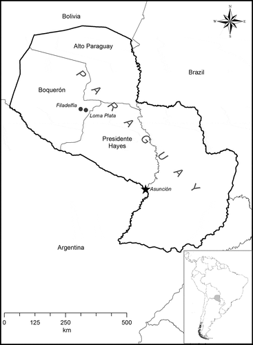
Our study area consists of the Gran Chaco region of Paraguay (), an area of 230,000 km2 that includes the departments of Boquerón, Alto Paraguay, and the Department of Presidente Hayes (Campos Krauer & Wisely, Citation2011). The Chaco is one of the major wooded grassland areas in central South America. In Paraguay, the Chaco is known as the western or occidental region. The Gran Chaco is a biogeographical province encompassing parts of four South American countries (Argentina, Bolivia, Brazil, & Paraguay). Topographically, it is a flat and generally featureless lowland within the Rio de la Plata drainage basin. Regional soils are generally loams or clay loams, principally formed from fluvial deposits with an overlay of eolian materials (Buol, Citation2007). The climate of the Chaco is generally semiarid with a pronounced east–west gradient in precipitation and humidity, with the most mesic areas lying nearer the Rio Parana in Paraguay, Argentina, and Brazil. Aridity progressively increases to the west, culminating in the driest areas where the Chaco transitions to the Andean foothills. This gradient results in division of the Chaco into three climatic subregions; the humid Chaco (precipitation generally >1000 mm\y), transitional Chaco (annual precipitation between 600 and 1000 mm\y), and semiarid Chaco with precipitation <600 mm/y (Adamoli, Sennhauser, Acero, & Rescia, 1990); Vargas-Gil, Citation1988). The predominant natural vegetation of the Chaco is open woodland or thorn forest, interspersed with grasslands (Breckle, Citation2002; Campos Krauer & Wisely, Citation2011). Tree form and structure vary along the climatic gradient; Schinopsis sp. (common name quebracho) are the dominant tree species, but palms of various types occur, along with woody shrubs typically composed of Prosopsis sp., Parkinonia sp., and Tabebuia sp. Notably, although semiarid throughout its extent, parts of the Paraguayan Chaco are characterized by the presence of wetlands.
Figure 1. The Paraguayan Chaco.
3. Methods
3.1. Analysis of land-cover change: the proximate and underlying causes
Land-use and land-cover change (LULCC) involves a complex set of socioeconomic, political, and institutional interactions. In general, the literature on LULCC breaks down these interactions into proximate and underlying causes of land-cover change, and these interactions have been well described by Lambin et al. (Citation1999), Ojima, Galvin, and Turner (Citation1994), and Meyer and Turner (Citation1992).
Proximate causes are defined as those human actions that directly affect the environment (Geist & Lambin, Citation2002). In the land-cover change literature (Arima, Walker, Perz, & Caldas, Citation2005; Caldas et al., Citation2007; Kaimowitz & Angelsen, Citation1998; Lambin, Citation1994; Pacheco & Poccard-Chapuis, Citation2012; among other important studies), proximate causes are exemplified by agricultural expansion (e.g., expansion of cropland, pastureland), expansion of infrastructure (e.g., road expansion, dam development), and wood extraction (e.g., logging). If on the one hand proximate causes are human activities, on the other hand underlying causes are indirect causes or root causes that can be conceptualized as the broader socioeconomic, political, technological, and demographic forces that underpin proximate causes (Geist & Lambin, Citation2002; Kaimowitz & Angelsen, Citation1998). Consequently, in the land-cover literature, deforestation is explained by a combination of multiple factors that act together rather than by a single causation (Geist & Lambin, Citation2002). In other words, there is a mix of forces acting together. For instance, economic factors influence land-use decision-making by altering prices, such as input price, transportation price, or beef price. These changes in prices can affect land conversion. For example, a decrease in input prices can stimulate deforestation. In the same context, policies and demographic factors both affect land conversion. The development of policies that give farmers good access to credit or markets (e.g., infrastructure development such as roads) can encourage forest conversion to cropland. In addition, increases or decreases in population have impacts on land use. Among the important demographic factors that affect land-cover change, migration is pointed out as the single most important one (Carr, Citation2009).
Thus, taking into consideration the availability of data for the Paraguayan Chaco, three underlying causes and two proximate causes of land-cover change were analyzed. The underlying causes include population change, infrastructure development, and market factors. The proximate causation will analyze factors such as agricultural and cattle expansion. Data for the analyses will come from the agricultural census provided by the Ministerio de Agricultura y Ganadería of Paraguay and from the demographic census provided by the Censo Nacional de Población y Vivendas of Paraguay. Thus, the methods used are a combination of qualitative and quantitative measures of agricultural expansion and forest loss.
3.2. Remote-sensing classification
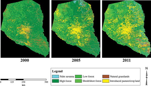
We used an 11 year time series (2000–2011) of image data from the MODIS Terra MOD13Q1 product to classify land cover into a six-class land-cover scheme (), partially based on the classification schemes of Clarke, Aide, Grau, and Riner (Citation2010) and Hansen et al. (Citation2003). We chose these data because the MODIS series, unlike Landsat Thematic Mapper (TM)\Enhanced Thematic Mapper Plus (ETM+) or comparable finer resolution imagery, is available as a temporally dense and complete time series for the period of interest. Had we used imagery from another source, we would not have been able to obtain the detailed temporal changes needed to address our research objective. Our choice of classification scheme followed from the study objectives and from our use of MODIS imagery, which has limited spatial resolution and, therefore, limited capability to discriminate LULC categories. Because our overall goal was to quantify deforestation, we chose a more general classification scheme, which lumped anthropogenic change categories (pasture\cropland) into a single class. This was also necessary because the crops cultivated in the Chaco are spectrally similar to the introduced grasses and, thus, difficult to discriminate at the coarse spectral and spatial resolution of the MODIS sensor.
Table 1. Descriptions of land-cover classes
All available Image data from the MOD13Q1 product were acquired in the form of 16 day composites from two data tiles, h12v10 and h12v11. Together, these tiles covered nearly all of the Chaco, with the exception of a small area in the extreme north. Although we acquired all of the available imagery, data quality issues (especially cloud cover) caused us to use only the austral winter scenes (June–August) for our classification. Blue, Red, NIR, and MIR reflectance images for each of the austral winter scenes from each year of the time series were extracted, clipped to borders of the Paraguayan Chaco, and geometrically corrected using the MODIS Reprojection Tool (U.S. Geological Survey, Citation2011). These images were then composited to form a multispectral image for each year of the analysis. Each of these 11 images (one for each year of the study) was then submitted to unsupervised classification using the ISODATA algorithm (Richards & Jia, Citation2006). Unsupervised classification was used because of the limited availability of reliable training data for the retrospective imagery, which restricted our capability to employ other decision strategies, such as supervised discriminant analysis or nonparametric decision tree rules. The resulting clusters were then assigned to land-cover classes using interactive, ‘head-up’ labeling.
Assessment of categorical accuracy for this map presented a challenge as only the most recent of the 11 classified maps could really be compared against the ‘ground truth.’ We assessed the accuracy of the 2011 classification by selecting a stratified random sample from the classified image then using a combination of in situ inspection (collected during a site visit in August 2011) and interpretation of high-resolution imagery to develop a reference data set of known cover types and locations. These reference data were used to construct a confusion matrix, from which classification accuracy and Kappa values were calculated (). Results for the 2011 classification show an overall classification accuracy of 84%, with a Kappa value of 0.82 ± 0.02, suggesting significant deviation from agreement by chance. Because the methods used in all 11 years of the classification were similar to those used in 2011, we proceeded under the assumption that the accuracy of each annual classification was similar to the accuracy of the 2011 map.
Table 2. Confusion matrix and accuracy assessment for 6-class land cover classification
4. Results
4.1. Forest loss in the Dry Chaco
Using a three-figure panel representing the beginning, the middle, and the end of the study period, we observed that the Dry Chaco shows profound change (). Estimates of the total area for each year show that the majority of the change consists of the conversion of two forested classes (high and low forest) into introduced grassland or pasture (i.e., crops and forage) (). Noteworthy is the fact that this type of land-cover conversion is similar to other land-cover changes in Latin America (Walker, Moran, & Anselin, Citation2000). Also, the changes in total area of cover appear to be generally monotonic throughout the time period of interest. In other words, there are no abrupt interannual changes in some years, with relatively little conversion in others.
Figure 2. Forest loss in the Paraguayan Dry Chaco, 2000–2011.
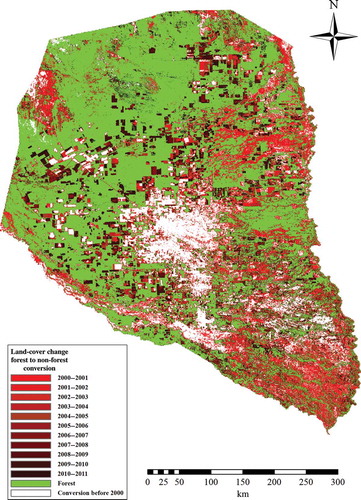
While the temporal pattern of change is generally uniform, the spatial pattern is not. Prior to 2000, the first year of record for our analysis, the main focal area of land-cover conversion was in central Chaco, surrounding the cities of Filadelfia and Loma Plata (). Much of this area was cleared of its original forest cover beginning in the 1930s and 1940s in order to create pasture and, to a lesser extent, cropland. Indeed, early remote-sensing imagery (in the 1970s and 1980s) already shows substantial alteration. Other studies (e.g., Hansen et al., Citation2003) suggested that change from forested cover to crop- or pastureland continued steadily throughout the 1990s. After 2000, substantial land-cover change is still mostly confined to the original central Chaco focal area, although additional emerging foci can be observed elsewhere, especially in the west and the south ().
Table 3. Estimation of forest loss in the Paraguayan Dry Chaco, 2000–2011
By 2005, it was further evident that areas of active land-cover conversion had increased beyond the original focus area in the central Chaco, becoming both more extensive and more widespread. More recent change foci can be seen emerging in the west and the south. These changes were beginning to emerge in the 2000 image and are now larger and more extensive. Smaller, more widely distributed changes were also apparent throughout the Chaco, but especially in the east, leading to a more extensive, less focused distribution of change compared to 2000 (). Imagery from 2011, the most recent year of the analysis, confirms the trend toward less concentrated changes in cover. Indeed, the pattern of change in 2011 shows change that is so widespread that it is now difficult to identify focal areas, as in previous times. In addition, the shape of the land-cover change is more easily identified than in the previous years. More recently, deforested areas appear more ‘square,’ suggesting that the unit of deforested area was much larger and likely cleared over a relatively short period of time (). This more regular, square pattern contrasts with earlier deforestation, which was done in smaller parcels and over longer time periods. This change in the geometry of deforested parcels also suggests a change in the technology used to remove the forest, from smaller-scale technology (e.g., clearing by chain saws or chaining) to larger-scale clearing using bulldozers and other heavy machinery. With the exception of the far northwestern region (near the Bolivian border), land-cover change is now distributed throughout the extent of the Paraguayan Chaco.
Figure 3. Land-cover dynamics in the Chaco – 2000)/2011.
4.2. The proximate and underlying causes of land-cover change
Historically, research in Latin America has generally suggested that agriculture (small- and large-scale) or the developments of ranching are the main drivers of land-cover change (Aldrich, Walker, Simmons, Caldas, & Perz, Citation2006; Pacheco, Citation2009; Sierra, Citation2000; Walker, Citation2003). More recent literature has recognized large-scale, mechanized agriculture as the dominant agent of land-cover change (Brannstrom et al., Citation2008; Brown et al., Citation2007; Catterson & Fragano, Citation2004; Galford et al., Citation2008; Huang et al., Citation2007). While the situation in the Paraguayan Chaco is similar in some respects to other Latin American countries and regions, a number of differences are also evident from our analysis. For instance, since the 1980s, soybean cultivation has been a major driver of land-cover change in the Argentinian Chaco and in the Amazon (Richards, Myers, Swinton, & Walker, Citation2012; Zak, Cabido, Cáceres, & Dias, Citation2008). In Paraguay, soybean cultivation has replaced cotton as the country’s most important commercial crop (Richards, Citation2011). However, unlike the situation in the Amazon (or in the Argentinian Chaco), the main impacts of soy production in Paraguay have been in the eastern Atlantic Forest region of the country. Soybean production in the Chaco region never became an important crop. In fact, among the three Department that comprise the Paraguayan Chaco, the Department of Presidente Hayes was the only one (in 1991)/1992) that had soybeans with a surface area of at least 200 ha. Since then, the cultivated area of soy has decreased to almost zero throughout the region (Ministerio de Agricultura y Ganadería, Paraguay [MAG], Citation2009).
However, soybean is not the only crop for which cultivated area has decreased in the Paraguayan Chaco. In general, all perennial and annual crops decreased in cultivated areas. From 1991)/1992 to 2008)/2009, the annual cultivated area decreased from 36,550 to 19,108 ha in the Chaco region (). For instance, manioc (an important staple crop for food security as well as an important source of energy for cattle) has decreased its cultivated area in the Chaco as well as throughout the whole country. In addition, the cultivated area of wheat and corn has decreased in the region. Corn formerly had a surface area of 720 ha in 1991)/1992, but its area was reduced to 402 ha in 2005)/2006 (MAG, Citation2009). Even cotton – previously Paraguay’s leading commercial crop, a crop that is especially well suited to the Paraguayan climate and soils, and one that is primarily grown by small farmers in the central region – decreased in surface area from a little over 11,500 ha in 1991)/1992 to <250 ha in the Chaco by 2008)/2009 (MAG, Citation2009).
Table 4. Annuals and perennials cultivated area and cattle heads by region: 1991)/1992–2008/2009
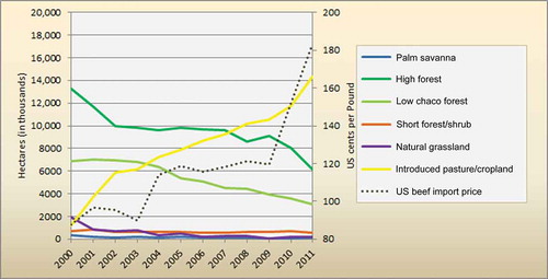
Clearly, the most important annual crops are decreasing in surface area, yet forest areas are also decreasing – and at an increasing rate. This raises the question, what is driving land-cover change in the region? Here, the similarity with other regions in Latin America stands out. Like in the Amazon, extensive cattle ranching has traditionally dominated the Chaco rural economy. Numbers of cattle in the Chaco region have increased from 2,388,735 head in 1991)/1992 to 3,855,660 head in 2008)/2009. This increase in cattle, in turn, has caused an increase in pasture area from 6,305,554 ha in 1990)/1991 to 10,777,819 ha in 2008, a 70% increase in the region (Ministerio de Agricultura y Ganadería, Paraguay [MAG], Citation2011). This rapid cattle expansion in the 1990s and 2000s seems to have occurred in conjunction with the region’s land-cover change. The MODIS data classification shows that low forest and high forestland decreased from 2000 to 2011 at the same time that introduced pastureland increased as a consequence of market factors (). Although this conversion does not explain why the decrease in the importance of agriculture vis-à-vis cattle ranching, the results suggest that beef prices – or market-related factors (e.g., demand for beef) – could be one factor affecting forest conversion (). Moreover, an analysis of the shape of the deforested areas in the MODIS data suggests that after 2005, this land use could be extensive ranching (see previous discussion and ).
Figure 4. Forest loss in Paraguayan Chaco, 2000–2011.
In the Chaco region, the Department of Presidente Hayes is by far the largest cattle producer, with extensive ranching in the savannas of the east and intensive ranching on the planted pastures of cleared land. Boquerón, on the other hand, had the largest increase in head of cattle between 2000 and 2009. From 669,849 head in 2000, this department increased to more than 1,100,000 head in 2009. These numbers seem more impressive if we take into consideration that with only 2% of the Paraguayan population, this state produces nearly 65% of the milk and meat of the country (MAG, Citation2011). In addition, dairy production is about 450,000 to 500,000 l of milk in a day, which forms 70% of the industry in central Chaco (MAG, Citation2011).
Unlike the other two Chaco departments, Alto Paraguay contains Paraguay’s largest forest reserves on undeveloped fertile land and the lowest land prices when compared to the eastern region. Thus, agriculture and cattle farming are starting to make inroads into Alto Paraguay, with the recent cultivation of sorghum and sugarcane (MAG, Citation2011).
Although agriculture and cattle ranching are apparently important proximate causations of land-cover change, it is important to highlight here that many studies of land-cover change have also observed strong correlation between population and road network in driving these changes (Allen & Barnes, Citation1985; Carr, Citation2004; Kaimowitz & Angelsen, Citation1998; Mather & Needle, Citation2000; Pfaff et al., Citation2007). While we did not do any statistical analysis of the correlation between population, roads, and deforestation in the Chaco, it is important to make some comments. From 1962 to 2002, the population in the Chaco increased from 74,129 to 135,186 people – an increase of 82% (). In addition, the projected population shows that the region will have more than 179,000 people by 2012 (Anuario Estadistico del Paraguay, Citation2012). Although rural and urban population size are almost equal in Paraguay, rural population is larger than urban population in the Chaco; nevertheless, the population density is very small for a region that is almost half of the country. Thus, population growth apparently could also be driving land-cover change in the region. However, it is important to note that – different from the eastern Atlantic region (or Oriental region) where Brazilian immigration accounts for more than 326,000 inhabitants (Santos & Cavalcante, Citation2008; Zamberlam, Corso, Filippin, Geremia, & Bresolin, Citation2010) and where the soy industry has been stimulated (Albuquerque, Citation2009; Richards, Citation2011) – in the Chaco region, there are only 1659 Brazilian immigrants (Zamberlam et al., Citation2010).
Table 5. Rural, urban, and total population in the Paraguayan Chaco
Also, not too distinct from other Latin American regions were roads that have opened the frontier (Kaimowitz, Mendez, Puntodewo, & Vanclay, Citation2002; Perz et al., Citation2007): in the Chaco region, the Ruta Transchaco (Transchaco Highway), the main road linking Asunción to the Chaco region, and the appearance of secondary routes seem to be contributing to the increasing land-cover change. However, the most challenging aspect for landholders in the Chaco region is the lack of infrastructure, such as paved roads. In fact, this is not just a regional problem. The road infrastructure coverage in Paraguay in terms of km of road per km2 is low, and until 2006, 12% to 17% of the overall road network was paved (Wilmsmeier & Sanchez, Citation2009).
5. Discussion and analysis
To understand the present land-cover change in the Paraguayan Chaco, it is important to start with the colonization of the region. Historically, the Chaco region was considered an empty region and was not colonized by ethnically European settlers until the end of the 1920s and beginning of the 1930s when Mennonites from Canada, Russia, and eastern Europe were given large areas in the region (today the cities of Filadelfia and Loma Plata; ) to avoid communist persecution (Hack, Citation1983). Because of the inhospitable environment for agriculture, the Chaco was sometimes called the ‘green hell’ because of the lack of roads, which created barriers to development (Klassen, Citation1991). However, this does not mean that the region did not have people. In fact, until the 1920s, the central part of the Paraguayan Chaco was dominated by the Lengua indigenous people, and the Chaco was approximately 90% woodland (called cati, thorn bushes, and dispersed tree growth) with the remaining land in extensive grassland known as campos (Hack, Citation1983). The Triple Alliance War against Brazil, Argentina, and Uruguay at the end of the nineteenth century destroyed Paraguay’s industry, economy, and society. The cost of the war and the debt created in this period to finance the war forced the country to sell its public lands at a very low price to private foreign investors to plant yerba mate, especially in the eastern region (Baer & Birch, Citation1984; Pastore, Citation1972). This operation established a highly unequal land tenure system, well known as latifúndiaFootnote1, in the hands of foreign capital (Domecq, Citation1911; Souchaud, Citation2002). In the case of the Chaco, the Triple War forced the Paraguayan government to sell almost 30% of its public land for the purpose of land speculation and to pay for the debts of the war (Nickson, Citation1981). Before the war, most of Paraguay’s rural areas were owned and maintained by the state, and after the war, much of the region’s state-owned land transferred to private ownership. As in many regions in South America, Paraguayan indigenous people saw their land occupied by foreign investors and colonists.
With the colonization, the Chaco grasslands were transformed into cotton fields, but by the 1960s, extensive cattle ranching began (Galeano, Citation1990). Until this date, Paraguay’s agricultural production was centered on food production for the domestic market, and the country was characterized by a skewed land distribution with the majority of the rural people occupying small landholdings, or minifuindio (Kleinpenning, Citation1984). Agricultural productivity in the country was very low as a result of underexploitation of the latifúndia. The collapse of the yerba mate market at the end of the 1950s generated huge unemployment and a struggle for land reform. Social mobilization increased, and awareness about the land tenure system and social injustice amplified in the country. On 4 May 1954, General Alfredo Stroessner took power in a military coup. Under the dictatorship of Stroessner, an initiative was set off to develop the country’s infrastructure and its agricultural sector. Good soils were major factors in developing roads that served as a stimulus to the soy industry in the Occidental region. In addition, road construction opened the eastern frontier to migration (Richards, Citation2011). As a result, within two decades, the country moved from a focus on domestic markets to a focus on agricultural exports. As domestic crop production declined, other important export crops (such as soy and cotton) started to grow, especially in the eastern region.
Meanwhile, in the Chaco region, besides an effort to improve agriculture production, the region was endowed with less favorable soils and less road infrastructure than the eastern region. Consequently, the lack of good soils and infrastructure restricted the development of agriculture. However, population growth occurred and a better international market for beef stimulated investments that resulted in faster conversion of the region’s forest to ranching. Consequently, over time, powerful cooperative farm groups transformed what used to be simple and modest meat and dairy enterprises into large cattle agribusinesses, thus transforming cattle ranching as the dominant economic activity of the region.
Government officials and the private sector project that Paraguay’s cattle herd will nearly double from its current 10 million head of cattle to 20 million by around 2020 (Joseph, Citation2011). It is important to observe that from the demand side, the population in Paraguay (and in the world) is growing and demand for basic food will continue to increase. On the supply side, cultivated land is on the decline in the region, and severe weather events in certain countries (e.g., drought in the USA) are increasing production costs and making production less competitive. Thus, limited supplies from traditional countries, such as Brazil and Argentina, have increased the cattle price (Condon, Citation2012) and given Paraguay (and the Chaco region) competitive advantages from low land costs. For instance, Paraguay’s average export beef price in 2005 was US$ 1767 per ton, while the average of the first seven months of 2011 was US$ 4845 per ton (Joseph, Citation2011). Consequently, the low-cost, grass-fed production and cheap land compared to Brazil, Argentina, or Uruguay will increase the possibility of expansion into new forest areas, thus attracting more investors eager to invest in the Chaco frontier.
6. Concluding remarks
The main objective of this research was to develop a general understanding of the proximate causes and underlying driving forces of deforestation in the Paraguayan Chaco. A brief review of Paraguay history shows that since the beginning of the nineteenth century, Paraguay has undergone important transformations. With the help of the Paraguay government, large-scale settlements began in the Chaco region: today the cities of Filadelfia and Loma Plata. Mennonite immigrants seeking land and religious freedom were the first to settle the region. After the 1960s, development policies that focused on infrastructure creation affected the country differently. While the Occidental region had good road development, the Oriental region lacked road infrastructure. In addition, the agricultural sector that focused on the domestic market redirected its goals to focus on the international market. Consequently, because of less favorable soils, the agricultural sector did not flourish in the Chaco region.
More recently, and particularly since the implementation of democratic governmental reforms in the late 1980s and early 1990s, migration to the region increased, mostly by Paraguayans and, more recently, by Brazilians. Migration into the region also occurred, spurred by economic opportunity of favorable international prices for beef production and cheap land. Consequently, our findings suggest that the main proximate cause of land-cover change in the region is cattle ranching, and this is in contrast with the Paraguayan eastern region where soybean expansion is the main driver of deforestation. On the other hand, the study suggests that among the underlying drivers of land-cover change are population growth and a favorable international market. In this context, it is important to note that the global demand for beef and agricultural products is increasing and this process of land-cover change in the Chaco is likely to continue in the years to come.
Thus, to conserve the Chaco forest, the government and other organizations that are responsible for environmental protection must develop and enforce laws designed to protect this valuable resource. It is important to note that landowners in the Chaco are obliged to leave at least 25% of rural premises as land set-asides for conservation and ecological rehabilitation (Article 42 of Forestry Law 422/73). But Paraguay presents the same problem as forest frontiers around the world: the region’s remoteness and the government’s lack of resources for monitoring or prosecuting lawbreakers have encouraged the illegal devastation of its marvelous forest. Finally, it is important to emphasize that although this article has provided insight into factors affecting land-cover change in the Chaco region, it must be highlighted that this is only part of the story. Our story, focusing on macroscale dynamics, does not explain microscale dynamics or household decisions that affect land-cover change. Thus, a full account of factors driving deforestation in the Paraguayan Chaco must ultimately comprehend a combination of macro- and microscale dynamics, not an easy task because of the lack of data in that country.
Acknowledgements
We thank Andrew Ricketts (Kansas State University) for his help with the field survey. The field survey was supported through an award from the National Agricultural Biosecurity Center, Kansas State University.
Notes
1. Latifúndia means a very large property. It comes from the Latin Latifundium where Lãtum means large, spacious, and fundus means farm, estate.
References
- Achard, F., Eva, D., Stibig, H. J., Mayaux, P., Gallego, J., Richards, T., & Malingreau, J. P. (2002). Determination of deforestation rates of the world’s humid tropical forests. Science, 297(5583), 999–1002.
- Adámoli, J., Sennhauser, E., Acero, J., & Rescia, A. (1990). Stress and disturbance: Vegetation dynamics in the dry Chaco region of Argentina. Journal of Biogeography, 17, 491–500.
- Agarwal, C., Green, G. M., Grove, J. M., Evans, T. P., & Schweik, C. M. (2002). A review and assessment of land-use change models: Dynamics of space, time, and human choice (General Technical Report NE-297). Newtown Square, PA: U.S. Department of Agriculture, Forest Service, Northeastern Research Station.
- Albuquerque, J. L. C. (2009). Os brasiguaios e os conflitos sociais na fronteira Paraguai-Brasil. Analise de Conjuntura OPSA. Rio de Janeiro: Observatorio Politico Sul-Americano.
- Aldrich, S., Walker, R., Simmons, C., Caldas, M., & Perz, S. (2012). Contentious land change in the Amazon’s arc of deforestation. Annals of the Association of American Geographers, 102(1), 103–128.
- Aldrich, S. P., Walker, R. T., Arima, E., Caldas, M., Browder, J., & Perz, S. (2006). Land cover and land use change: Processes of social stratification in agricultural expansion. Economic Geography, 82(3), 265–288.
- Allen, J. C., & Barnes, D. F. (1985). The causes of deforestation in developing countries. Annals of the Association of American Geographers, 75, 163–184.
- Angelsen, A., & Kaimowitz, D. (1999). Rethinking the causes of deforestation: Lessons from economic models. World Bank Research Observer, 14(1), 73–98.
- Anuario Estadistico del Paraguay. (2012). Dirección General de Estadística. Asunción: Encuestas y Censos.
- Arima, E., Richards, P., Walker, R. T., & Caldas, M. (2011). Statistical confirmation of indirect land use change in the Brazilian Amazon. Environmental Research Letters, 6, 1–7.
- Arima, E. Y., Walker, R. T., Perz, S. G., & Caldas, M. (2005). Loggers and forest fragmentation: Behavioral models of road building in the Amazon basin. Annals of the Association of American Geographers, 95, 525–541.
- Baer, W., & Birch, M. (1984). Expansion of the economic frontier: Paraguayan growth in the 1970s. World Development, 12(8), 738–798.
- Barbieri, A., & Carr, D. L. (2005). Gender-specific out-migration, deforestation and urbanization in the Ecuadorian Amazon. Global and Planetary Change, 47(2–4), 99–110.
- Brannstrom, C., Jepson, W., Filippi, A., Redo, D., Xu, Z., & Ganesh, S. (2008). Land change in the Brazilian Savanna (Cerrado), 1986–2002: Comparative analysis and implications for land use policy. Land Use Policy, 25, 579–595.
- Breckle, S. W. (2002). Walter’s vegetation of the earth. Berlin: Springer.
- Browder, J. (2002). The urban-rural interface: Urbanization and tropical forest cover change. Urban Ecosystems, 6, 21–41.
- Browder, J. O. & Godfrey, B. J. (1997). Rainforest cities: Urbanization, development and globalization of the Brazilian Amazon. New York, NY: Columbia University Press.
- Brown, J. C., Jepson, W. E., Kastens, J. H., Wardlow, B. D., Lomas, J. M., & Price, K. P. (2007). Multitemporal, moderate-spatial-resolution remote sensing of modern agricultural production and land modification in the Brazilian Amazon. GIScience and Remote Sensing, 44(2), 117–148.
- Brown, K., & Pearce, D. W. (1994). The causes of tropical deforestation. In K. Brown & D. W. Pearce (Eds.), The economic and statistical analysis of factors giving rise to the loss of the tropical forests (pp. 2–5). London: University College London Press.
- Buol, S. W. (2007). Soils. In T. T. Veblen, K. R. Young, & A. R. Orme (Eds.), The physical geography of South America (pp. 101–111). Oxford: Oxford University Press.
- Caldas, M., Walker, R., Arima, E., Perz, S., Wood, C., Aldrich, S., & Simmons, C. (2007). Theorizing land cover and land use change: The peasant economy of Amazonian deforestation. Annals of the Association of American Geographers, 97(1), 86–110.
- Caldas, M., Walker, R., Simmons, C., Perz, S., Aldrich, S., Pereira, R., … Arima, E. (2010). Settlement formation and land cover and land use change: A case study in the Brazilian Amazon. Journal of Latin American Geography, 9(1), 124–144.
- Campos Krauer, J. M., & Wisely, S. M. (2011). Deforestation and cattle ranching drive rapid range expansion of capybara in the Gran Chaco ecosystem. Global Change Biology, 17, 206–218.
- Carr, D. L. (2004). Proximate population factors and deforestation in tropical agricultural frontiers. Population and Environment, 25(6), 585–612.
- Carr, D. L. (2009). Population and deforestation: Why rural migration matters. Progress in Human Geography, 33(3), 355–378.
- Catterson, T. M., & Fragano, F. V. (2004). Tropical forestry and biodiversity conservation in Paraguay (Final Report of Section 118/119 Assessment, EPIQ II Task No. 1). Asunción: USAID.
- Clarke, M. L., Aide, T. M., Grau, H. R., & Riner, G. (2010). A scalable approach to mapping annual land cover at 250 m using MODIS times series data: A case study in the Dry Chaco ecoregion of South America. Remote Sensing of Environment, 114(11), 2816–2832.
- Condon, J. (2012). Competitor watch: Cattle shortage sends South American prices higher. Beef Central. Retrieved from http://www.beefcentral.com/p/news/article/559
- Domecq, M. (1911). La República del Paraguay en su Primer Centenario, 1811–1911 [The Republic of Paraguay in Its First Century]. Buenos Aires: Compañía Sudamericana de Billetes de Banco.
- Faminow, M. D. (1998). Cattle, deforestation and development in the Amazon: An economic, agronomic and environmental perspective (1st ed.). New York, NY: CAB International.
- Galeano, L. (1990). Modernización agrarian, diferenciación campesina y escenarios políticos. In L. Galeano (Ed.), Procesos agrarios y democracia en Paraguay y América Latina (pp. 19–42). Asunción: Centro Paraguayo de Estudios Sociologicos.
- Galford, G. L., Mustard, J. F., Melillo, J., Gendrin, A., Cerri, C. C., & Cerri, C. E. P. (2008). Wavelet analysis of MODIS time series to detect expansion and intensification of row-crop agriculture in Brazil. Remote Sensing of the Environment, 112, 576–587.
- Geist, H. J., & Lambin, E. F. (2001). What drives tropical deforestation? (LUCC Report Series No. 4). Louvain-la-Neuve: CIACO.
- Geist, H. J., & Lambin, E. F. (2002). Proximate causes and underlying driving forces of tropical deforestation. Bioscience, 52(2), 143–150.
- Hack, H. (1983). Land problems in the Paraguayan Chaco. Boletín de Estudios Latinoamericanos y del Caribe, 34, 99–115.
- Hannah, L., Lohse, D., Hutchinson, C., Carr, J. L., & Lankerani, A. (1994). A preliminary inventory of human disturbance of world ecosystems. Ambio-Journal of Human Environment, 23, 246–250.
- Hansen, M. C., DeFries, R. S., Townshend, J. R. G., Carroll, M., Dimiceli, C., & Sohlberg, R. A. (2003). Global percent tree cover at a spatial resolution of 500 meters: First results of the MODIS vegetation continuous fields algorithm. Earth Interactions, 7, 1–15.
- Huang, C., Kim, S., Alstatt, A., Townshend, J., Davis, P., Song, K., … Musinskiy, J. (2007). Rapid loss of Paraguay’s forest and the status of protected areas – A landsat assessment. Remote Sensing of Environment, 106(4), 460–466.
- Irwin, E. G., & Geoghegan, J. (2001). Theory, data, methods: Developing spatially explicit economic models of land use change. Agriculture, Ecosystems and Environment, 1764, 1–18.
- Janzen, D. H. (1988). Tropical dry forests. In E. O. Wilson (Ed.), The most endangered major tropical ecosystem (pp. 130–137). Washington, DC: Biodiversity, National Academy Press.
- Joseph, K. (2011). Livestock and products annual: Global agricultural information network (Gain Report). Washington, DC: USDA Foreign Agricultural Service.
- Kaimowitz, D., & Angelsen, A. (1998). Economic, models of tropical deforestation: A review. Bogor: Center for International Forestry Research.
- Kaimowitz, D., Mendez, P., Puntodewo, A., & Vanclay, J. K. (2002). Spatial regression analysis of deforestation in Santa Cruz, Bolivia. In C. H. Wood & R. Porro (Eds.), Deforestation and land use in the Amazon (pp. 41–65). Gainesville, FL: University Press of Florida.
- Kant, S., & Redantz, A. (1997). An econometric model of tropical deforestation. Journal of Forest Economics, 3(1), 51–86.
- Klassen, P. P. (1991). Die Mennoniten in Paraguay. Begegnung mit Indianern und Paraguayern (Vol. 2). Bolanden-Weierhof: Mennonitischer. Geschichtsverein.
- Kleinpenning, J. M. G. (1984). The integration and colonisation of the Paraguayan Chaco (94 p.). Nijmegen: Geografisch en Planologisch Instituut Katholieke Universiteit. Nijmeegse Geografische Cahiers 24 (IAI A 91/1391).
- Lambin, E. F. (1994). Modelling deforestation processes: A review (TREES Series B: Research Report 1). Luxembourg: Office of Official Publications of the European Community.
- Lambin, E. F., Baulies, X., Bockstael, N., Fischer, G., Krug, T., Leemans, R., … Vogel, C. (1999). Land-use and land-cover change (LUCC) – Implementation strategy (IGBP Report 48/IHDP Report 10). A core project of the International Geosphere-Biosphere Programme and the International Human Dimensions Programme on Global Environmental Change. Stockholm: IGBP Secretariat & Bonn, Switzerland: IHDP Secretariat.
- Lambin, E. F., Geist, H. J., & Lepers, E. (2003). Dynamics of land-use and land-cover change in tropical regions. Annual Review of Environment and Resources, 28, 205–241.
- Lambin, E. F., Turner II B. L., Geist, H. J., Agbola, S. B., Angelsen, A., Bruce, J. W., … Xu, J. (2001). The causes of land use and land cover change: Moving beyond myths. Global Environment Change: Human and Policy Dimensions, 11(4), 261–269.
- Mather, A. S., & Needle, C. L. (2000). The relationships of population and forest trends. The Geographical Journal, 166(1), 2–13.
- Meyer, W. B., & Turner II B. L. (1992). Human population growth and global land-use/land-cover change. Annual Review of Ecology and Systematics, 23, 39–61.
- Ministerio de Agricultura y Ganadería, Paraguay [MAG]. (2009). Produccíon Agropecuaria: Sintesis Estadisticas (Zafra Agricola 2008/2009). Asunción: Omega Editorial S.R.L.
- Ministerio de Agricultura y Ganadería, Paraguay [MAG]. (2011). Produccíon Agropecuaria: Sintesis Estadisticas (Zafra Agricola 2010/2011). Asunción: Omega Editorial S.R.L.
- Moglia, G., & Giménez, A. M. (1998). Anatomic features of the hydrosystem of the main tree species of the Chaco region in Argentina. Revista de Investigaciones Agrarias Sistemas y Recursos Forestales, 7, 53–71.
- Mooney, H. A., Bullock, S. H., & Medina, E. (1995). Introduction. In S. H. Bullock, H. A. Mooney, & E. Medina (Eds.), Seasonally dry tropical forests (pp. 1–8). Cambridge: Cambridge University Press.
- Nickson, R. A. (1981). Brazilian colonization in the eastern border region of Paraguay. Journal of Latin American Studies, 13(1), 111–131.
- Ojima, D. S., Galvin, K. A., & Turner II, B. L. (1994). The global impact of land-use change. Bioscience, 44(5), 300–304.
- Pacheco, P. (2009). Agrarian change, cattle ranching and deforestation: Assessing their linkages in southern Pará. Environment and History, 15, 493–520.
- Pacheco, P., & Poccard-Chapuis, R. (2012). The complex evolution of cattle ranching development amid market integration and policy shifts in the Brazilian Amazon. Annals of the Association of American Geographers, 102(6), 1366–1390.
- Pastore, C. (1972). La Lucha por la Tierra en el Paraguay (Terceira Edición Corrigida). Asunción: Intercontinental Editora.
- Pennington, R. T., Prado, D. E., & Pendry, C. A. (2000). Neotropical seasonally dry forests and Quaternary vegetation changes. Journal of Biogeography, 27, 261–273.
- Perz, S. G., Caldas, M., Arima, E., & Walker, R. (2007). Socio-spatial processes of unofficial road-building in the Amazon: Socioeconomic and biophysical explanations. Development and Change, 38, 529–551. doi:10.1111/j.1467-7660.2007.00422.x
- Pfaff, A., Robalino, J., Walker, R., Reis, E., Aldrich, S., Caldas, M., … Kirby, K. (2007). Road investments, spatial spillovers & deforestation in the Brazilian Amazon. Journal of Regional Science, 47(1), 109–123.
- Pfaff, A. S. P. (1999). What drives deforestation in the Brazilian Amazon? Journal of Environmental Economics and Management, 37, 26–43.
- Redford, K., Taber, A., & Simonetti, J. (1990). There is more to diversity than the tropical rain forest. Conservation Biology, 4, 328–330.
- Reis, E., & Guzmán, R. (1994). An economic model of Amazon deforestation. In K. Brown & D. Pearce (Eds.), The causes of tropical deforestation: The economic and statistical analysis of factors giving rise to the loss of tropical forests (pp. 172–192). London: University College of London Press.
- Richards, J. A., & Jia, X. (2006). Remote sensing digital image processing. Berlin: Springer-Verlag.
- Richards, P. (2011). Soy, cotton, and the final Atlantic forest frontier. The Professional Geographer, 63(3), 343–363.
- Richards, P., Myers, R. J., Swinton, S. M., & Walker, R. T. (2012). Exchange rates, soybean supply response, and deforestation in South America. Global Environmental Change, 22(2), 454–462.
- Rudel, T., & Roper, J. (1996). Regional patterns and historical trends in tropical deforestation, 1976–1990: A qualitative comparative analysis. Ambio, 25(3), 160–166.
- Rudel, T., & Roper, J. (1997). The paths to rain forest destruction: Cross-national patterns of tropical deforestation, 1975–90. World Development, 25(1), 53–65.
- Sala, O., Chapin III, F., Armesto, J., Berlow, R., Bloomfield, J., Dirzo, R., … Wall, D. (2000). Global biodiversity scenarios for the year 2100. Science, 287, 1770–1774.
- Santos, M. E. P., & Cavalcanti, M. C. (2008). Identidades híbridas, línguas(gens) provisórias – alunos ‘brasiguiaos’ em foco. Trabalhos de Lingua Aplicada, 47, 429–446.
- Sierra, R. (2000). Dynamics and patterns of deforestation in the western Amazon: The Napo deforestation front, 1986–1996. Applied Geography, 20, 1–16.
- Souchaud, S. (2002). Migrations et mutations des systèmes agraires: la culture brésilienne du soja au Paraguay, Revue Européenne des Migrations Internationales. Poitiers, REMI, 18(2), 105–137.
- Southgate, D., Sierra, R., & Brown, L. (1991). The causes of tropical deforestation in Ecuador: A statistical analysis. World Development, 19(9), 1145–1151.
- Stern, P. C., Young, O. R., & Druckman, D. (1992). Global environmental change: understanding the human dimensions. Washington, DC: National Academy Press.
- Tálamo, A., & Caziani, S. M. (2003). Variation in woody vegetation among sites with different disturbance histories in the Argentine Chaco. Forest Ecology and Management, 184, 79–92.
- Tucker, R. P., & Richards, J. F. (1983). Global deforestation and the nineteenth Century world economy. Durham, NC: Duke University Press.
- Turner II, B. L. (2002). Toward integrated land-change science: Advances in 1.5 decades of sustained international research on land-use and land-cover change. In W. Steffen, J. Jäger, D. J. Carson, & C. Bradshaw (Eds.), Challenges of a changing earth (pp. 21–26). Berlin: Springer.
- US Geological Survey. (2011). MODIS Reprojection tool (Version 4.1). Washington, DC: Author.
- Vargas Gil, R. (1988). Chaco sudamericano: regiones naturales. In X Reunión Grupo Campos y Chaco (pp. 16–20). FAO UNESCO MAB INTA.
- Walker, R. T. (2003). Mapping process to pattern in the landscape change of the Amazonian frontier. Annals of the Association of American Geographers, 93(2), 376–398.
- Walker, R. T., Moran, E. F., & Anselin, L. (2000). Deforestation and cattle ranching in the Brazilian Amazon: External capital and household process. World Development, 8(4), 683–699.
- Wilmsmeier, G., & Sánchez, R. J. (2009). Landlocked countries in South America: Transport system challenges (Serie Recursos Naturales e Infraestructura, No. 142). Santiago: CEPAL, Naciones Unidas.
- Wunder, S. (2000). The economics of deforestation: The example of Ecuador. London: Macmillan Press Ltd.
- Zak, M., Cabido, M., Cáceres, D., & Días, S. (2008). What drives accelerated land cover change in central Argentina? Synergistic consequences of climatic, socioeconomic, and technological factors. Environmental Management, 42, 181–189.
- Zamberlam, J., Corso, G., Filippin, J., Geremia, E., & Bresolin, E. (2010). Emigrantes Brasileiros no Praguai: Presença Scalabrimana. Coleção Pastoral & Migrações. Porto Alegre: Solidus.