
Abstract
Forest fragmentation has several phases; thus, the ecological significance of each phase during a particular period of time must be interpreted. To interpret, this study quantifies the magnitude of forest loss and the changes in the temporal pattern of fragmentation in the State of Selangor, peninsular Malaysia. Using the decision tree model of land transformation, five phases of forest fragmentation were identified: perforation, dissection, dissipation, shrinkage and attrition. This analysis showed that the magnitude of forest loss was the highest during the dissipation phase. The patchiness analysis showed that dissipation contributes to the highest environmental uncertainty found for the forest patches. This study can be considered a first step in the exploration of the properties and the behavioural pattern shown by the spatial process of forest fragmentation.
1. Introduction
Land transformation due to human activities such as forestry, agriculture, urbanisation and infrastructure development is relevant to various environmental issues and problems (Forman, Citation1995). These activities are closely linked to the loss of forested areas. Forested areas that are transformed to other land uses are subject to fragmentation. Generally, fragmentation refers to the breakage of a continuous natural land cover or habitat into patches that vary in size and configuration (Fahrig, Citation2003). In this sense, forest fragmentation is a spatial process of land transformation from one type to another caused by natural and human activities (Forman, Citation1995; Jaeger, Citation2000). Fragmentation creates patchiness, that is, the variability and unevenness of the habitat dispersion pattern in a particular landscape, which is linked with entropy (Bogaert, Farina, & Ceulemans, Citation2005). Both fragmentation and patchiness affect many aspects of ecosystem structure and function, including habitat isolation (DeFries, Hansen, Newton, & Hansen, Citation2005; Van Laake & Sánchez-Azofeifa, Citation2004), loss of biodiversity (Barlow, Peres, Henriques, Stouffer, & Wunderle, Citation2006; Castelletta, Thiollay, & Sodhi, Citation2005; Wessels, Reyers, van Jaarsveld, & Rutherford, Citation2003) and decrease in soil fertility (Mainville et al., Citation2006).
In many regions, forest fragmentation has been widely quantified with various landscape metrics related to fragmentation, such as patch size, patch density and the nearest-neighbour index (Imbernon & Branthomme, Citation2001; Long, Nelson, & Wulder, Citation2010; Ranta, Blom, Niemelä, Joensuu, & Siitonen, Citation1998; Reddy, Sreelekshmi, Jha, & Dadhwal, Citation2013; Skole & Tucker, Citation1993; Tang, Bu, Yang, Zhang, & Chang, Citation2012; Trejo & Dirzo, Citation2000). Another approach to the measurement of forest fragmentation is to use a single index developed from a combination of several fragmentation indices, such as forest edge bordered by human land use, non-forest area and patch size coefficient of variation (e.g., Abdullah & Nakagoshi, Citation2007; Bogaert, Van Hecke, Salvador-Van Eysenrode, & Impens, Citation2000; Butler, Swenson, & Alig, Citation2004; Rudel & Roper, Citation1997). Nevertheless, all measurements of this type are conducted for a specific year and do not consider that forest fragmentation is a spatial process that has several phases or stages (Forman, Citation1995; Jaeger, Citation2000).
Based on Bogaert, Ceulemans, and Salvador-Van Eysenrode (Citation2004) and Koffi et al. (Citation2007), there are five phases of land transformation spatial process related to forest fragmentation – attrition, dissection, fragmentation, perforation and shrinkage. Fragmentation phase is also considered a combination of dissection and shrinkage (Forman, Citation1995), and the term ‘dissipation’ has been applied to this combination by Jaeger (Citation2000). Jaeger (Citation2000) has also suggested that the term ‘fragmentation’ refers to a comprehensive notion of all the phases. In this context, the spatial process of forest fragmentation involves the opening up of a particular type of natural land cover to produce other types of cover. This process breaks the original land cover into patches of various sizes, and these patches are ultimately eliminated from the landscape. In a dynamic landscape, these phases occur concurrently, and the magnitude of forest loss in each phase may change spatially and temporally (Dunn, Sharpe, Guntenspergen, Stearns, & Yang, Citation1991; Sharp, Guntenspergen, Dunn, Leitner, & Stearns, Citation1987). Therefore, the ecological significance of each phase over a period of time can be interpreted. In contrast, the occurrence of phases of forest fragmentation is not considered if forest fragmentation is measured with multiple metrics or a single index.
Before any interpretation can be performed, however, the magnitude of forest loss in each phase of the spatial process of fragmentation and the way in which forest loss changes over time must be understood quantitatively. Furthermore, an understanding of the ways in which each phase affects the dispersion and variability of patch size (i.e. patchiness) of forest is also important because patchiness reflects the structural order or disorder which is linked with entropy (Antrop, Citation1998). Thus, in this study, landscape ecology approach is considered as a basis for quantification to facilitate the interpretation of the process. This is because the concepts and theories in landscape ecology offer an insight into the linkages between landscape changes (e.g., due to forest fragmentation) and ecological consequences at the landscape level (Gardner, Milne, Turnei, & O’Neill, Citation1987; Turner, Citation1989; Turner & Gardner, Citation1991; Urban, O’Neill, & Shugart, Citation1987).
Therefore, the objective of this study is to provide an insight into the spatial process of forest fragmentation over a period of time, using the State of Selangor in peninsular Malaysia as a model. Selangor is considered appropriate because it is the most significant region of forest fragmentation in peninsular Malaysia (Abdullah & Nakagoshi, Citation2007). Generally, historical land development in peninsular Malaysia from the 1950s until the 1970s involved the conversion of forested areas into agricultural land, primarily for rubber and oil palm plantations (Aiken & Moss, Citation1975; Brookfield & Byron, Citation1990; Kumar, Citation1986: Leong Fee, Citation1985). However, a transition in the government’s development policy subsequently occurred, and the focus since the 1980s on the manufacturing sector has changed the pattern of land development by allocating forested areas to housing and other components of infrastructure. This situation is typical in Selangor (Abdullah & Hezri, Citation2008) because the state is the hub for many socio-economic development activities in peninsular Malaysia. To achieve the objective, this study addresses the following questions: (1) What is the magnitude of forest loss in each fragmentation phase and how does the temporal pattern change and (2) How does each fragmentation phase affect the patchiness of forests?
2. Methods
2.1. The setting
The State of Selangor is located between 2°35′ and 3°60′N and between 100°45′ and 102°00′E on the west coast of peninsular Malaysia (). The total area is approximately 800,000 ha and is bordered by three states: Perak, Pahang and Negeri Sembilan (). Topographically, hilly and mountainous areas up to 1900 m above sea level (a.s.l.) are located in the eastern and northeastern parts of the state. Undulating terrain up to 300 m a.s.l. can be found in the centre of the state, whereas flat land extends along the coastal margin. The climate is equatorial, with an annual mean maximum temperature between 30°C and 35°C. The humidity is high, ranging between 80% and 90%.
Figure 1. Location of the State of Selangor, peninsular Malaysia.
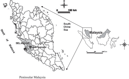
The socio-economic development of Selangor has changed from dependence on rubber and tin mining between the 1950s and the 1960s to a primary focus on the manufacturing sector in the 1980s and thereafter. These changes have fostered the significant contribution made by the manufacturing sector to the gross domestic product of Selangor. For example, the manufacturing sector contributed more than 50% of Selangor’s total gross domestic product in the 1990s (Economic Planning Unit Malaysia, Citation2001). Selangor’s rapid economic growth has created many employment opportunities. These opportunities induced people to migrate to Selangor from other states in Malaysia. This situation has contributed to the increase in the population of Selangor. Originally, Kuala Lumpur was the capital of Selangor, but in 1974, the city was declared a Federal Territory and officially separated from the state (). Therefore, the analysis in this study included Kuala Lumpur.
2.2. Data sources
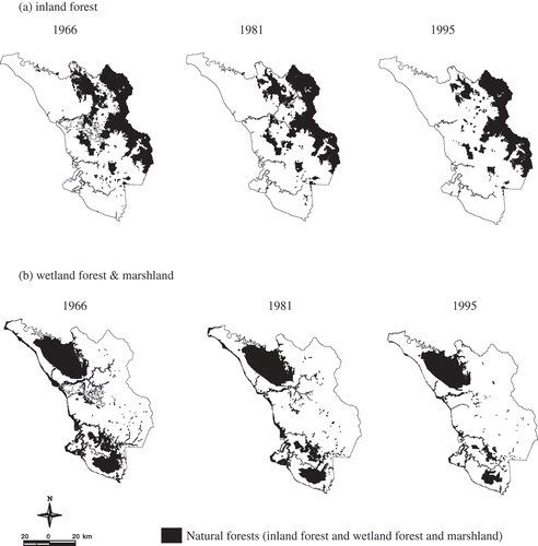
The primary data for this study were furnished by the digitised natural forest (inland forest and, wetland forest and marshland) maps of Selangor in 1966, 1981 and 1995 ( and ) developed by the Institute for Environment and Development (LESTARI), Universiti Kebangsaan Malaysia. The three digitised natural forest maps were based on land use maps (scale 1:250,000) produced by the Soil Management Division of the Department of Agriculture, Malaysia. The land use maps were based on the interpretation of aerial photos (scale 1:40,000) and on ground truthing for verification. The topographic maps of the state (scale 1:50,000) were used as a base to geo-code all the digitised maps with the ArcInfo 8.0.1 geographic information system. In this study, 1966 was used as the reference year, and data development was performed with ArcView 3.2.
Figure 2. (a–b) Natural forest maps (inland forest and wetland forest and marshland) of the study area in 1966, 1981 and 1995.
2.3. Identifying fragmentation phases
Quadrat sampling is appropriate for revealing spatial variation in landscape indices in a particular area (Nakagoshi, Hikasa, Koarai, Goda, & Sakai, Citation1998; Turner, O’Neill, Conley, Conley, & Humphries, Citation1990). Furthermore, this approach is commonly used for spatial analysis and has been applied to landscape pattern analysis (e.g., Haines-Young, Citation1992; Poudevigne & Alard, Citation1997). Therefore, 100 grid squares (10 km × 10 km) developed with ArcView 3.2 were overlaid on the natural forest maps for 1966, 1981 and 1995 to produce grid maps. A grid size of 10 km × 10 km was used because it represents about 1% of the total study area, which is suitable for a regional scale study. Furthermore, it is also a typical scale for examining fragmentation trends at the regional level (Long et al., Citation2010; Wulder et al., Citation2008). These grid maps were then used as a base in this study. First, grid squares from 1966 with more than 50% of their area covered by inland forest and wetland forest and marshland were selected. Grid squares covered by inland forest were classified as forest grid squares, whereas grid squares covered by wetland forest and marshland were classified as wetland grid squares. The 1966 was used as the reference year, and the same grid squares were used with the 1981 and 1995 maps. All grid squares showing reductions in the total area of inland forest and wetland forest and marshland between 1966 and 1981 (Period 1) and between 1981 and 1995 (Period 2) were selected to identify the fragmentation phases.
To identify the fragmentation phases in each grid square, the decision tree model of the land transformation process (Koffi et al., Citation2007 based on Bogaert et al., Citation2004) was used (). The decision tree model was used because it considered three fragmentation metrics: total patch area, total edge and number of patches (Bogaert et al., Citation2004). These metrics represent the key elements of landscape pattern measures that encompass most of the phenomena associated with the patterns observed in a landscape (Trani & Giles, Citation1999).
Figure 3. Decision tree model of land transformation used to identify forest fragmentation phases. a – total patch area; p – total edge; n – number of patches. a0, p0 and n0 refer to the state before transformation, whereas a1, p1 and n1 refer to the state after transformation at time t + 1. Tobs = a1/a0; t = a0−a1 > 0.
Source: Based on Bogaert et al. (Citation2004) and Koffi et al. (Citation2007).
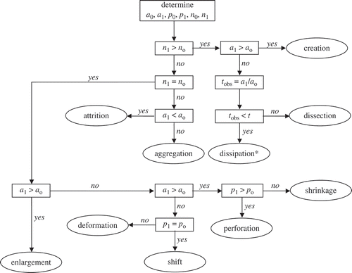
The decision tree model specifies 10 spatial processes of land transformation. Attrition, dissection, fragmentation, perforation and shrinkage involve land cover degradation, whereas creation, aggregation, deformation, shift and enlargement involve the appearance of new land cover (Bogaert et al., Citation2004). Because the causes of forest fragmentation are primarily associated with land cover degradation, only the first five processes were initially considered in this analysis. The fragmentation phase in the decision tree model of land transformation resembles dissipation, which is a combination of dissection and shrinkage (Forman, Citation1995; Jaeger, Citation2000). Therefore, the term ‘dissipation’ was used in this study instead of ‘fragmentation’ to avoid confusion with the term ‘fragmentation phases’, which represents all of the phases of the spatial process of forest fragmentation. Based on this analysis, in Period 1, 14 wetland grid squares experienced fragmentation and the number was the same in Period 2 (). For forest grid square, in Period 1, 12 grids experienced fragmentation and 11 in Period 2 (). Finally, all grid squares with five spatial processes of fragmentation – perforation, dissection, dissipation, shrinkage and attrition – () (hereafter referred as fragmentation phase) were used in the subsequent analysis.
Table 1. Type of forest fragmentation phase in each wetland grid square (wetland forest and marshland) in Period 1 and Period 2 based on decision tree model of land transformation.
Table 2. Type of forest fragmentation phase in each forest grid square (inland forest) in Period 1 and Period 2 based on decision tree model of land transformation.
Table 3. Description of each fragmentation phase analysed in this study.
2.4. Magnitude of forest loss in each fragmentation phase
In this analysis, the magnitude of forest loss was based on the rate of forest loss occurring in each grid square. This rate was calculated as follows:
Rate of forest loss, %/year = the difference in the total area of natural forest i (i is either inland forest or wetland forest and marshland) between time t + 1 and time t divided by the total area of natural forest i in time t multiplied by 100 and divided by the number of years included in the analysis:
The average rate of forest loss in each fragmentation phase was then calculated as follows:
Average rate of forest loss, ARf (%/year) = Total rate of forest loss for p divided by the total number of grid squares (n) of p, where p is a fragmentation phase:
2.5. Pattern change of forest loss in each fragmentation phase
In this analysis, the overall rate of natural forest loss in each fragmentation phase in Period 1 (between 1966 and 1981) and Period 2 (between 1981 and 1995) was calculated. Therefore, the grid squares in Period 1 and Period 2 were classified according to the fragmentation phase occurring in each period. The overall rate of natural forest loss (%/year) of phase p in period t was calculated with Equations (1) and (2), where p is the fragmentation phase and t is either Period 1 or Period 2. The same procedure was applied to a separate analysis conducted in each type of natural forest. This analysis was performed to explore the differences between the two natural forests during Period 1 and Period 2.
2.6. Natural forest patchiness in each fragmentation phase
The natural forest patchiness in each fragmentation phase was determined by measuring their patch dispersion pattern using Shannon’s evenness index (Theil, Citation1967; Thomas, Citation1981), hereafter referred as patch evenness. The index was selected because it describes information on measurement related to the dispersion and concentration of a phenomenon (Bogaert et al., Citation2005). The formula of the patch evenness index is as follows:
The evenness, however, does not convey any information about patch size variability (McGarigal & Marks, Citation1995) which is significant to environmental uncertainty; thus, the frequency of patch size was determined. The patch size (x) in each grid square was divided into four classes: x < 10 ha; 10 < x < 100 ha; 100 < x < 1000 ha; x > 1000 ha. In this analysis, the grid squares were classified based on the previously identified fragmentation phases (p). The frequency of the four groups of patch size value in each grid square of p was summed and divided by the total number of grid squares of p to provide an average value of patch size frequency.
3. Results
3.1. Magnitude of forest loss in each fragmentation phase
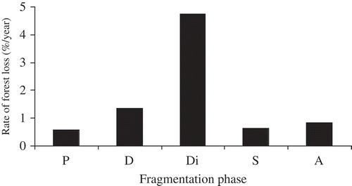
This analysis revealed that dissipation has the highest magnitude of forest loss, with more than 4%/year (). The rate is three times higher than that for dissection, which is approximately 1.5%/year (). This is followed by attrition, perforation and the least is shrinkage, but all has the magnitude of forest loss less than 1%/year ().
Figure 4. Magnitude of forest loss (%/year) in each fragmentation phase. P: perforation, D: dissection, Di: dissipation, S: shrinkage, A: attrition.
3.2. Pattern change of forest loss in each fragmentation phase
shows the pattern change of forest loss of each fragmentation phase in Period 1 and Period 2. Generally, the forest loss in dissipation, dissection and shrinkage in Period 1 was less than that in Period 2, whereas the opposite pattern was shown by attrition. The forest loss in perforation, however, was not much different between the two periods.
Figure 5. (a–c) Temporal changes in magnitude of forest loss in each fragmentation phase in Period 1 and Period 2. P: perforation, D: dissection, Di: dissipation, S: shrinkage, A: attrition.
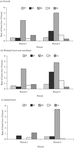
In wetland forest and marshland, the forest loss in dissipation, dissection, shrinkage and perforation was higher in Period 2 than in Period 1, whereas the opposite pattern was shown by attrition (). In inland forest, dissipation and perforation did not occur in Period 1 while attrition did not occur in Period 2 (). Only dissection and shrinkage occurred in both periods. In Period 2, dissection and shrinkage were less than that in Period 1.
3.3. Natural forest patchiness in each fragmentation phase
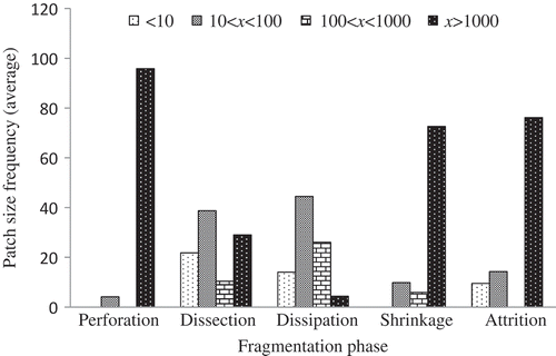
In general, the highest patch evenness of natural forest was found for dissipation (). This is followed by the patch evenness for dissection, which was slightly higher than that for attrition, whereas the patch evenness for perforation and shrinkage was less than 0.1 (). The patch size of natural forest for dissection and dissipation has high variability compared with the variability for perforation, shrinkage and attrition (). The pattern of patch size variability was similar between dissection and dissipation and between shrinkage and attrition ().
Table 4. Patch evenness of natural forests (inland forest and wetland forest and marshland) caused by each fragmentation phase.
Figure 6. Patch size variability caused by each fragmentation phase.
4. Discussion
Landscape ecology approach was used to quantify the magnitude of forest loss for five fragmentation phases and how they affect the patchiness of forest. The analyses revealed that the magnitude of forest loss and its patchiness was highest in the dissipation phase. However, the other important finding was that the overall magnitude of forest loss particularly in the dissipation phase was generally higher in Period 2 than in Period 1. This situation could be related to the development policy that emphasised the manufacturing sector, which has been catalysing urbanisation process in the state. The expansion of urbanisation process in the state was indicated by the significant increased in the proportion of urban and built-up area during the period between 1981 and 1995 (Abdullah & Nakagoshi, Citation2006). Furthermore, by 1995, the urban and built-up area also showed a significant and predictable interaction with forest fragmentation (Abdullah & Nakagoshi, Citation2007). In the same period, rubber and oil palm land uses remained as the explanatory variables that contributed to the loss of natural forest in the state (Abdullah & Nakagoshi, Citation2007). This suggests that increase in urbanisation process had amplified the breaking up or subdividing and shrinking of the natural forest patches. The amplification of the processes (i.e. subdividing and shrinking) explains the dominancy of dissipation over the other phases during Period 2. The amplification also contributes to the high magnitude of forest loss for dissipation in Period 2 compared to that in Period 1.
The patchiness analysis revealed that perforation, dissection, dissipation, shrinkage and attrition have different effect to the patchiness (dispersion and patch size variability) of natural forest in the study area. The differences might be due to the properties and behavioural pattern that each phase has. In this context, dissipation apparently contributes substantially to the environmental uncertainty of natural forest as this phase involves a combination of subdividing and shrinking processes that contributes to increase in patch number, size variability and density. The patchiness for perforation and shrinkage considered the least because the patch number of forest remained the same. Although the total edge length increases for perforation and decreases for shrinkage, this does not contribute much to the dispersion and patch size variability. However, the high patchiness for dissipation does not necessarily explain that dissipation is the most important but it is rather a peak phase to cause loss and patchiness of natural forest.
The different magnitude of forest loss between Period 1 and Period 2 in each phase also provides information about the sizes of patches that are favourable or that are susceptible to conversion for development. It has been suggested that small fragmented forests (i.e. <100 ha) are more susceptible to development or conversion (Turner & Corlett, Citation1996). For these reasons, such forests are easily reduced and eliminated from the landscape. The reduction and elimination are closely linked to attrition. This suggests that attrition is highly associated with the reduction and elimination of small fragmented forests, whereas shrinkage, dissection and dissipation are closely linked to the reduction of continuous and large fragmented forests. Therefore, the tendency to convert the continuous and large fragmented forests might be higher in Period 2 than that in Period 1, whereas many patches of small fragmented forest might be eliminated during Period 1. This is supported by the finding of this study that the magnitude of forest loss for attrition in Period 1 was higher than that in Period 2 and vice versa for dissection, dissipation and shrinkage.
In wetland forest and marshland, a similar pattern was observed in the pattern change of magnitude of forest loss in Period 1 and Period 2. This means that the overall pattern change of fragmentation phase was influenced mainly by the pattern changes in wetland forest and marshland. In Period 2, this forest was not only converted to oil palm plantation but also targeted for the development of urban and built-up areas (Abdullah & Hezri, Citation2008). The occurrence of attrition in Period 1 and Period 2 suggests that intense use of this forest occurred during both periods. The result is consistent with the findings by Abdullah and Nakagoshi (Citation2008) that the active conversion of wetland forest and marshland to oil palm plantation occurred throughout the periods studied. Conversely, for inland forest, the pattern indicates that many small fragmented patches were eliminated during Period 1 as attrition was the dominant phase but that this phase did not occur during Period 2. The dominant phase in Period 2 was dissipation, which indicates the highly conversion of inland forest for development during the period.
Generally, the focus of the approach used in this study was towards the processes involved (i.e. perforation, dissection, dissipation, shrinkage and attrition) that caused fragmentation and patchiness of forest. It is contrary to the other newly developed spatial pattern analysis such as morphological spatial pattern analysis: a pixel-based analysis of forest fragmentation spatial pattern, which focuses on the morphological characters of forest patches such as core, patch, perforated, edge, connector and islet (Ostapowicz, Vogt, Riitters, Kozak, & Estreguil, Citation2008; Vogt et al., Citation2007). Nevertheless, there is a possibility to apply the approach used in this study to evaluate how the fragmentation phases affect the morphological characters of the forest patches. This can be evaluated by combining the approach and morphological spatial pattern analysis with some modification applied. A successful example is a combination of morphological spatial pattern analysis with network analysis to identify the key structural forest connectors in fragmented landscape (Saura, Vogt, Velázquez, Hernando, & Tejera, Citation2011).
The findings of this study revealed that perforation, dissection, dissipation, shrinkage and attrition phases have significance to the magnitude of the natural forest loss and its patchiness. This develops an understanding of the relationship between magnitude of forest loss, the spatial processes and entropy, which could not be achieved when forest fragmentation is measured using multiple metrics or a single index. Understanding the relationship provides a quick protocol to determine the dominant phases of forest fragmentation present in the area of interest. It also can assist planners and decision-makers in analysing the factors that drive land transformation and an insight for addressing issues related to land use planning and management and forest conservation.
5. Conclusions
This study used landscape ecology approach to quantify the spatial process of forest fragmentation over a period of time. The quantification differs from the use of a single fragmentation index that specifies the level of fragmentation at a specific time (i.e. a specific year). The different magnitude of forest loss in each phase affects the uncertainty associated with the natural forest in the study area. The pattern change occurring in each fragmentation phase suggests the association of each phase with the tendency of patches of particular sizes to be converted to other land uses. The occurrence of the highest magnitude of forest loss in dissipation suggests that dissipation is the most ecologically significant phase for natural forests and for environmental uncertainty. The details of these circumstances allow the ecological significance of forest fragmentation over a period of time to be interpreted.
In addition to these findings about the magnitude of forest loss, the pattern of change and its effect on natural forest patchiness, further research may reveal the unknown properties and behaviour of the spatial process of forest fragmentation. In this context, an extension of this case study to other states in peninsular Malaysia is relevant. Such further research will also determine whether the findings of this study are also valid for other states with different economic, social, demographic and biophysical characteristics. In addition, this study should be viewed as a first step towards understanding the properties and behavioural pattern of the spatial process of forest fragmentation. It is important to explore this information to facilitate the interpretation of its ecological significance.
Acknowledgements
This study was partly funded by Research University Grant UKM-OUP-ASPL-6/2007 courtesy of the Ministry of Higher Education Malaysia. I would like to thank the anonymous reviewer for comments and suggestions, which helped me to improve the content and presentation of this article.
References
- Abdullah, S. A., & Hezri, A. A. (2008). From forest landscape to agricultural landscape in the developing tropical country of Malaysia: Pattern, process, and their significance on policy. Environmental Management, 42, 907–917. doi:10.1007/s00267-008-9178-3
- Abdullah, S. A., & Nakagoshi, N. (2006). Changes in landscape spatial pattern in the highly developing State of Selangor, peninsular Malaysia. Landscape and Urban Planning, 77, 263–275. doi:10.1016/j.landurbplan.2005.03.003
- Abdullah, S. A., & Nakagoshi, N. (2007). Forest fragmentation and its correlation to human land use change in the State of Selangor, peninsular Malaysia. Forest Ecology and Management, 241, 39–48. doi:10.1016/j.foreco.2006.12.016
- Abdullah, S. A., & Nakagoshi, N. (2008). Changes in agricultural landscape pattern and its spatial relationship with forestland in the State of Selangor, peninsular Malaysia. Landscape and Urban Planning, 87, 147–155. doi:10.1016/j.landurbplan.2008.05.008
- Aiken, S. R., & Moss, M. R. (1975). Man’s impact on the tropical rainforest of peninsular Malaysia: A review. Biological Conservation, 8, 213–229. doi:10.1016/0006-3207(75)90065-8
- Antrop, M. (1998). Landscape change: Plan or chaos? Landscape and Urban Planning, 41, 155–161. doi:10.1016/S0169-2046(98)00068-1
- Barlow, J., Peres, C. A., Henriques, L. M. P., Stouffer, P. C., & Wunderle, J. M. (2006). The responses of understorey birds to forest fragmentation, logging and wildfires: An Amazonian synthesis. Biological Conservation, 128, 182–192. doi:10.1016/j.biocon.2005.09.028
- Bogaert, J., Ceulemans, R., & Salvador-Van Eysenrode, D. (2004). Decision tree algorithm for detection of spatial processes in landscape transformation. Environmental Management, 33, 62–73. doi:10.1007/s00267-003-0027-0
- Bogaert, J., Farina, A., & Ceulemans, R. (2005). Entropy increase of fragmented habitats: A sign of human impact? Ecological Indicators, 5, 207–212. doi:10.1016/j.ecolind.2005.02.002
- Bogaert, J., Van Hecke, P., Salvador-Van Eysenrode, D., & Impens, I. (2000). Landscape fragmentation assessment using a single measure. Wildlife Society Bulletin, 28, 875–881.
- Brookfield, H., & Byron, Y. (1990). Deforestation and timber extraction in Borneo and the Malay Peninsula. The record since 1965. Global Environmental Change: Human and Policy Dimension, 1, 42–56. doi:10.1016/0959-3780(90)90006-U
- Butler, B. J., Swenson, J. J., & Alig, R. J. (2004). Forest fragmentation in the Pacific Northwest: Quantification and correlations. Forest Ecology and Management, 189, 363–373. doi:10.1016/j.foreco.2003.09.013
- Castelletta, M., Thiollay, J.-M., & Sodhi, N. S. (2005). The effects of extreme forest fragmentation on the bird community of Singapore Island. Biological Conservation, 121, 135–155. doi:10.1016/j.biocon.2004.03.033
- DeFries, R., Hansen, A., Newton, A. C., & Hansen, M. (2005). Increasing isolation of protected areas in tropical forests over the past twenty years. Ecological Applications, 15, 19–26. doi:10.1890/03-5258.
- Dunn, C. P., Sharpe, D. M., Guntenspergen, G. R., Stearns, F., & Yang, Z. (1991). Methods for analysing temporal changes in landscape pattern. In M. G. Turner & R. H. Gardner (Eds.), Quantitative methods in landscape ecology (pp. 173–198). New York, NY: Springer.
- Economic Planning Unit Malaysia. (2001). Eight Malaysia plan. Economic planning unit. Kuala Lumpur: Prime Minister Department.
- Fahrig, L. (2003). Effects of habitat fragmentation on biodiversity. Annual Review of Ecology, Evolution, and Systematics, 34, 487–515. doi:10.1146/annurev.ecolsys.34.011802.132419
- Forman, R. T. T. (1995). Land mosaic. The ecology of landscapes and regions. Cambridge: Cambridge University Press.
- Gardner, R. H., Milne, B. T., Turnei, M. G., & O’Neill, R. V. (1987). Neutral models for the analysis of broad-scale landscape pattern. Landscape Ecology, 1, 19–28. doi:10.1007/BF02275262
- Haines-Young, R. H. (1992). The use of remotely-sensed satellite imagery for landscape classification in Wales (U.K.). Landscape Ecology, 7, 253–274. doi:10.1007/BF00131256
- Imbernon, J., & Branthomme, A. (2001). Characterization of landscape patterns of deforestation in tropical rain forests. International Journal of Remote Sensing, 22, 1753–1765. doi:10.1080/01431160118426
- Jaeger, J. A. G. (2000). Landscape division, splitting index, and effective mesh size: New measures of landscape fragmentation. Landscape Ecology, 15, 115–130. doi:10.1023/A:1008129329289
- Koffi, K. J., Deblauwe, V., Sibomana, S., Neuba, D. F. R., Champluvier, D., De Canniere, C., … Bogaert, J. (2007). Spatial pattern analysis as a focus of landscape ecology to support evaluation of human impact on landscapes and diversity. In S. K. Hong, N. Nakagoshi, & Y. Morimoto (Eds.), Landscape ecological applications in man-influenced area: Linking man and nature systems (pp. 7–32). New York, NY: Springer.
- Kumar, R. (1986). The forest resources of Malaysia: Their economics and development. Singapore: Oxford University Press Pte.
- Leong Fee, W. (1985). Policies for agricultural development in peninsular Malaysia. Land Use Policy, 2, 30–40. doi:10.1016/0264-8377(85)90052-3
- Long, J. A., Nelson, T. A., & Wulder, M. A. (2010). Characterizing forest fragmentation: Distinguishing change in composition from configuration. Applied Geography, 30, 426–435. doi:10.1016/j.apgeog.2009.12.002
- Mainville, N., Webb, J., Lucotte, M., Davidson, R., Betancourt, O., Cueva, E., & Mergler, D. (2006). Decrease of soil fertility and release of mercury following deforestation in the Andean Amazon, Napo River Valley, Ecuador. Science of the Total Environment, 368, 88–98. doi:10.1016/j.scitotenv.2005.09.064
- McGarigal, K., & Marks, B. J. (1995). FRAGSTAT. Spatial analysis program for quantifying landscape structure. USDA Forest Service General Technical Report PNW-GTR-351.
- Nakagoshi, N., Hikasa, M., Koarai, M., Goda, T., & Sakai, I. (1998). Grid map analysis and its application for detecting vegetation changes in Japan. Applied Vegetation Science, 1, 219–224. doi:10.2307/1478951
- Ostapowicz, K., Vogt, P., Riitters, K. H., Kozak, J., & Estreguil, C. (2008). Impact of scale on morphological spatial pattern of forest. Landscape Ecology, 23, 1107–1117. doi:10.1007/s10980-008-9271-2
- Poudevigne, I., & Alard, D. (1997). Landscape and agricultural patterns in rural areas: A case study in the Brionne Basin, Normandy, France. Journal of Environmental Management, 50, 335–349. doi:10.1006/jema.1997.0134
- Ranta, P., Blom, T., Niemelä, J., Joensuu, E., & Siitonen, M. (1998). The fragmented Atlantic rain forest of Brazil: Size, shape and distribution of forest fragments. Biodiversity and Conservation, 7, 385–403. doi:10.1023/A:1008885813543
- Reddy, C. S., Sreelekshmi, S., Jha, C. S., & Dadhwal, V. K. (2013). National assessment of forest fragmentation in India: Landscape indices as measures of the effects of fragmentation and forest cover change. Ecological Engineering, 60, 453–464. doi:10.1016/j.ecoleng.2013.09.064
- Rudel, T., & Roper, J. (1997). Forest fragmentation in the humid tropics: A cross-national analysis. Singapore Journal of Tropical Geography, 18, 99–109. doi:10.1111/1467-9493.00007
- Saura, S., Vogt, P., Velázquez, J., Hernando, A., & Tejera, R. (2011). Key structural forest connectors can be identified by combining landscape spatial pattern and network analyses. Forest Ecology and Management, 262, 150–160. doi:10.1016/j.foreco.2011.03.017
- Sharp, D. M., Guntenspergen, G. R., Dunn, C. P., Leitner, L. A., & Stearns, F. (1987). Vegetation dynamics in a southern Wisconsin agricultural landscape. In M. G. Turner (Ed.), Landscape heterogeneity and disturbance (pp. 137–155). New York, NY: Springer-Verlag.
- Skole, D., & Tucker, C. J. (1993). Tropical deforestation and habitat fragmentation in the Amazon: Satellite data from 1978 to 1988. Science, 260, 1905–1910. doi:10.1126/science.260.5116.1905
- Tang, J., Bu, K., Yang, J., Zhang, S., & Chang, L. (2012). Multitemporal analysis of forest fragmentation in the upstream region of the Nenjiang River Basin, Northeast China. Ecological Indicators, 23, 597–607. doi:10.1016/j.ecolind.2012.05.012
- Theil, H. (1967). Economics and information theory. Amsterdam: North-Holland.
- Thomas, R. W. (1981). Information statistics in geography. Norwich: W.H. Hutchins & Sons.
- Trani, M. K., & Giles Jr., R. H. (1999). An analysis of deforestation: Metrics used to describe pattern change. Forest Ecology and Management, 114, 459–470. doi:10.1016/S0378-1127(98)00375-2
- Trejo, I., & Dirzo, R. (2000). Deforestation of seasonally dry tropical forest a national and local analysis in Mexico. Biological Conservation, 94, 133–142. doi:10.1016/S0006-3207(99)00188-3
- Turner, I. M., & Corlett, R. T. (1996). The conservation value of small, isolated fragments of lowland tropical rain forest. Trends in Ecology & Evolution, 11, 330–333.
- Turner, M. G. (1989). Landscape ecology: The effect of pattern on process. Annual Review of Ecology and Systematics, 20, 171–197. doi:10.1146/annurev.es.20.110189.001131
- Turner, M. G., & Gardner, R. H. (1991). Quantitative methods in landscape ecology. New York, NY: Springer-Verlag.
- Turner, S. J., O’Neill, R. V., Conley, W., Conley, M. R., & Humphries, H. C. (1990). Pattern and scale: Statistics for landscape ecology. In M. G. Turner & R. H. Gardner (Eds.), Quantitative methods in landscape ecology (pp. 17–49). New York, NY: Springer.
- Urban, D. L., O’Neill, R. V., & Shugart, H. H. (1987). Landscape ecology. Bioscience, 37, 119–127. doi:10.2307/1310366
- Van Laake, P. E., & Sánchez-Azofeifa, G. A. (2004). Focus on deforestation: Zooming in on hot spots in highly fragmented ecosystems in Costa Rica. Agriculture, Ecosystems & Environment, 102, 3–15. doi:10.1016/j.agee.2003.07.001
- Vogt, P., Riitters, K. H., Estreguil, C., Kozak, J., Wade, T. G., & Wickham, J. D. (2007). Mapping spatial patterns with morphological image processing. Landscape Ecology, 22, 171–177. doi:10.1007/s10980-006-9013-2
- Wessels, K. J., Reyers, B., van Jaarsveld, A. S., & Rutherford, M. C. (2003). Identification of potential conflict areas between land transformation and biodiversity conservation in north-eastern South Africa. Agriculture, Ecosystems & Environment, 95, 157–178. doi:10.1016/S0167-8809(02)00102-0
- Wulder, M. A., White, J. C., Han, T., Coops, N. C., Cardille, J. A., Holland, T., & Grills, D. (2008). Monitoring Canada’s forests. Part 2: National forest fragmentation and pattern. Canadian Journal of Remote Sensing, 34, 563–584. doi:10.5589/m08-081