
Abstract
This study examines deforestation in a part of the Niger Delta region of Nigeria between 1987 and 2013 using remote sensing data and geographic information systems. The results indicate an increasing rate of deforestation, an increasing rate of water body loss and a decreasing rate of exposed surface/settlement increase. The results also show that the rate at which cropland/secondary vegetation is increasing is above average while sandbar is increasing below average. The implications of these changes include environmental degradation resulting from loss of biodiversity and loss of forest goods and services. These losses can also affect the social and economic conditions of local people. The study recommends that policies and strategies targeted at slowing down the rate of forest loss and degradation should be pursued.
1. Introduction
The constant quest for economic growth and social development has resulted in an increased demand for resources. This demand implies that man would have to resort to measures that may have negative impacts on the natural environment such as clearing the forest for infrastructure development or food production, mining and deep-sea probes. Etter, McAlpine, Phinn, Pullar, and Possingham (Citation2006) posited that the human impact on forest resources are majorly influenced by spatial characteristics such as proximity to roads and settlements, distance to forest edges, soil fertility, rainfall pattern, topography, and population growth and density. Government policies, economic processes and the level of economic development are other factors that influence deforestation (Angelsen & Kaimowitz, Citation1999). The World forest resources have continued to reduce primarily because of anthropogenic impacts driven by the need to meet the demand for industrial and social development necessary for economic growth. Goldewijk and Ramankutty (Citation2004) noted that the rate of deforestation increased globally between 1700 and 1990. The impacts of large-scale forest depletion are particularly severe in parts of South-East Asia, sub-Saharan Africa and South America.
Natural forest depletion, especially in the tropical region, has been of major concern to conservationist and governments because of its rapid rate of change and widespread nature (Read & Lam, Citation2002). In spite of this, much of the estimates derived for tropical forest loss have remained controversial (Agarwal, Silander, Gelfand, Dewar, & Mickelson, Citation2005; Etter, McAlpine, Wilson, Phinn, & Possingham, Citation2006). Several studies have highlighted the importance of the tropical forest and its rapid rate of depletion (Kaimowitz, Mendez, Puntodewo, & Vanclay, Citation2002; Linkie, Smith, & Leader-Williams, Citation2004; Read & Lam, Citation2002; Zipperer, Citation1993). Skole and Tucker (Citation1993) asserted that the tropical forest is home to more than half of all plants and animal species despite the fact that it occupies less than 7% of the terrestrial surface. Deforestation therefore poses a serious threat to biological diversity and is a primary cause of the present extinction crisis (Wilcove, McLellan, & Dobson, Citation1986; Wilcox & Murphy, Citation1985).
Studies have shown that the loss of forest resources has negative consequences on the quality of the environment (Angelsen & Kaimowitz, Citation1999; Goldewijk & Ramankutty, Citation2004; Ludeke, Maggio, & Reid, Citation1990). In order to increase our understanding of the impact of rapid deforestation on environmental systems, information is needed on the pattern of change as well as the social and physical factors that lead to the observed changes (Lambin, Citation1997).
The need for environmental protection and forest conservation is even more critical in the Niger Delta region of Nigeria, which is characterised by sensitive ecosystems (Akegbejo-Samsons & Omoniyi, Citation2009; Fabiyi, Citation2011). However, most studies on environmental change in Nigeria has focused on urban sprawl (Balogun, Adeyewa, Balogun, & Morakinyo, Citation2011; Mahmud & Achide, Citation2012; Njike, Igbokwe, & Orisakwe, Citation2011; Obiefuna, Idris, & Uduma-Olugu, Citation2011), while others analysed specific plant species and human impacts on forest resources (Aweto, Citation1990; Azeez, Ikponmwonba, Popoola, & Amusa, Citation2010; Mmon & Arokoyu, Citation2010; Onuche, Citation2010). Also, apart from Mengistu and Salami (Citation2007), who investigated land use/land cover change and detection in a part of southwestern Nigeria, and Fabiyi (Citation2011), who examined the impact of change actors on vegetation loss, research on the pattern of deforestation in the Niger Delta region of Nigeria seems to be lacking. The objectives of this study therefore are to analyse the pattern of deforestation and determine the rate and dimension of deforestation in the study area.
2. Conceptual and theoretical framework
2.1. The concepts of deforestation and land degradation
Lambin, Rounsevell, and Geist (Citation2000) asserted that land cover includes the physical, biological, and human components of the Earth’s surface and immediate subsurface. Land use entails the exploitation of the land cover by man in satisfying his social, cultural, spiritual, economic and physical needs.
The need for social, economic and cultural development by man may cause a stress on environmental resources. A manifestation of this stress is deforestation, which is the term most often used in describing the threat to the tropical forest (Phillips, Citation1997). Deforestation is the conversion of forest land for uses other than its natural cover, e.g. cultivation, mining, and human structures such as urban infrastructure (FAO, Citation2000). FAO (Citation2000) further noted that deforestation occurs when the tree canopy cover falls below a minimum percentage threshold of 10%. Geist and Lambin (Citation2004) observed that deforestation is an important contributor to global environmental change. However, the rate of deforestation varies within and between regions in response to policy and institutional failure and economic, technological, cultural and population factors (Geist & Lambin, Citation2002; Rolfe, Bennett, & Louviere, Citation2000). Tropical deforestation, often depicted as an important environmental concern, is the cause of biodiversity and ecosystem loss, soil degradation and vulnerability of people and places to climate change and socio-economic disturbances (Lambin, Geist, & Lepers, Citation2003).
Though deforestation is a commonly cited cause of tropical forest depletion, it is only one of the threats confronting the tropical forest. Habitat fragmentation has also been identified as a key factor in tropical forest depletion (Phillips, Citation1997; Skole & Tucker, Citation1993). Also closely related to the concept of deforestation is forest degradation, which is the reduction of the quality and quantity of forest cover because of human activities (FAO, Citation2000). Lambin (Citation1999) noted that forest degradation, usually caused by an increase in forest disturbances, is a process capable of significantly altering the tropical forest density or structure of vegetation cover leading to a lower species composition and productive capacity of the forest. There has been an increase in forest disturbances and deforestation in the Niger Delta because of the increasing population pressure on the natural environment, the need for fertile agricultural land and the quest for more forest products and services required for industrial raw materials (Enaruvbe & Ige-Olumide, Citation2014; Fabiyi, Citation2011), resulting in the degradation of forest and land resources in the region. Land degradation entails soil erosion and fertility decline. This implies a decline in the usability of the land for productive purposes such as agriculture (Lambin, Citation1997), which may also necessitate the clearing of more forest land for agricultural purpose.
Studies (Darwin, Tsigas, Lewandrowski, & Raneses, Citation1996; Kaimowitz et al., Citation2002) have discussed the importance of the tropical forest, while the impacts of environmental change and conversion were highlighted by Lambin et al. (Citation2000). These impacts include quality of water, land and air resources, ecosystem processes and services, and climate conditions. Tropical forest conservation is therefore an important way of mitigating the increasing impacts of climate change on man and his natural environment. Changes in land use/land cover and the need for biodiversity conservation are two critical issues that have gained attention in tropical forest research in recent years. There has, however, been intense debate on the most appropriate approach to adopt in tropical forest conservation (Bawa & Seidler, Citation1998; Terborgh, Citation2000).
2.2. Land use and land cover change models
The increasing awareness of the role of the tropical forest on the status of climate condition, biodiversity and net primary production, local-to-global land status and ecosystem, and other valuable functions have prompted research interests in land use/land cover change (Turner II et al. Citation2001). Because of this, a number of models have been formulated to improve our understanding of land use/land cover change processes. These models serve as tools for supporting the analysis of the causes and consequences of land use dynamics and provide a basis for planning and policy formulation (Verburg, Schot, Dijst, & Veldkamp, Citation2004).
Land use models have been categorised based on the scale and methods of analysis (Angelsen & Kaimowitz, Citation1999; Verburg et al., Citation2004). Angelsen and Kaimowitz (Citation1999), for instance, categorised deforestation models into three classes: analytical, simulation and empirical models. They noted that the models exist at three distinct levels: microeconomic models, regional models and macroeconomic models. Lambin et al. (Citation2003) also identified three categories of land use/land cover models. However, in spite of the similarities in the characteristics of these models and those of Angelsen and Kaimowitz (Citation1999), Lambin et al. (Citation2003) used different terms in describing their models. They referred to the categories as agent-based models, the systems models and the narrative models. They noted that each of the approaches evaluates the impact of the interactions between macro-structure and micro-agency in different ways. It has been noted that explanatory variables appear to follow a consistent pattern with scale (Veldkamp & Lambin, Citation2001).
The aim of land use/land cover models is to provide answers to the questions of where, when and why land use/land cover changes take place (Angelsen & Kaimowitz, Citation1999; Lambin et al., Citation2000; Veldkamp & Lambin, Citation2001). Studies, however, show that quantitative data on where, when and why land use/land cover changes take place on a global scale are still incomplete (Lambin, Citation1997). Angelsen and Kaimowitz (Citation1999) asserted that the factors affecting deforestation or other land use/land cover change, the interaction between them and the extent of their impacts vary significantly from one location to another. Also, a high geographic variation in land cover and variation in biophysical and socio-economic drivers of land use/land cover changes as well as institutional structure exist (Etter, McAlpine, Phinn, et al., Citation2006; Serneels & Lambin, Citation2001; Veldkamp & Lambin, Citation2001). This variation in geographic situations reduces the predictive ability of current land use/land cover model (Angelsen & Kaimowitz, Citation1999; Verburg, de Koning, Kok, Veldkamp, & Bouma, Citation1999). This has, therefore, resulted in the need to adopt different approaches in the modelling of land use and environmental changes in order to gain a better understanding of the processes at work in shaping the observed changes. The approaches adopted include agent-based approach, the system approach and the narrative approach.
2.2.1. The agent-based approach
The focus of the agent-based approach is on individual land use decision-making process. Lambin et al. (Citation2003) noted that the approach represents the motivation behind decisions and the external factors that influence land use decisions. The approach applies the rule of economic decision-making processes in developing land use/land cover change models. These models are broadly divided into two groups: spatially explicit and non-spatially explicit models (Irwin & Geoghegan, Citation2001). Spatially explicit land use/land cover models focus on disaggregate patterns of land use/land cover change and can identify critical areas of land use/land cover change. The models provide insight into the pattern and factors driving the observed changes (Verburg et al., Citation1999). Irwin and Geoghegan (Citation2001) categorised spatially explicit models of land use/land cover change into simulation models, estimation models and hybrid models. Verburg et al. (Citation1999), however, referred to the categories as explorative and predictive models. Explorative (simulation) models aim at designing alternative land use pattern using optimisation techniques based on biophysical potentials and socio-economic variables. Projective (estimation) models, on the other hand, provide an understanding of the processes of possible changes in land use in the near future as a function of driving forces (Agarwal et al., Citation2005). These predictions provide insights into the extent and location of land use/land cover changes (Agarwal et al., Citation2005; Serneels & Lambin, Citation2001).
Lambin et al. (Citation2000) categorise land use/land cover models into four groups: empirical-statistical, stochastic, optimisation and dynamic (process-based) simulation models. There is, however, consensus among researchers on the need for integrated land use/land cover models in which the elements of the various modelling approaches are combined in ways that most adequately provide answers to specific research questions.
Sun, Forsythe, and Waters (Citation2007) simulated land use pattern in Calgary, Canada, using the Markov chain and cellular automata analysis based on land use and transportation interactions. They observed that the model reveals the manner in which land use is likely to evolve in relation to transportation system and that this interaction may have encouraged the increasing rate of urban sprawl in Calgary between 1985 and 2001.
Serneels, Said, and Lambin (Citation2001) observed that land use decisions, which may be the outcome of individual farmer’s decisions, influence the pattern of land use change in the Mara wildlife reserve in Kenya. They described the resulting spatial pattern as an outer ring, characterised by centripetal expansion of cultivation that is causing a compression of the spatial systems, an inner ring, which acts as a buffer zone and is subjected to rangeland modification, and the reserve, which is relatively stable.
The goal of non-spatially explicit models is to explain the equilibrium land use pattern resulting from the aggregate decision-making processes of individual actors. Irwin and Geoghegan (Citation2001) grouped the models as microeconomic models and other economic factors across regions. The non-spatial explicit model tend to ignore the spatial component in predicting the pattern of land use/land cover change as it assumes that space is a ‘featureless plane’ where the only consideration is distance to the central business district. Ogunleye, Adeola, Ojo, and Aduradola (Citation2004), for example, used statistical analysis in evaluating the pattern of forest depletion in Olokomeji forest reserve in southwestern Nigeria. They observed that farming activities in Olokomeji forest reserve have resulted in changes in the vegetation composition in the reserve.
2.2.2. The system approach
The system approach examines the influence of institutional and organisational arrangement of society on land use/land cover change pattern. These institutions, including cultural, local, regional and national agencies, operate interactively at different spatial and temporal scales and therefore link local conditions to global processes (Lambin et al., Citation2003). The system perspective evaluates the impact of changes in economic systems on environmental conditions.
Geist and Lambin (Citation2002) showed that at the underlying level, public and individual decisions are largely a result of changes in the national, regional or global economic opportunities and/or policies mediated by local-scale institutional factors. However, proximate factors including regional modes of agricultural expansion, wood extraction and infrastructure expansion are important determinants of deforestation in an area. They noted the difficulty in modelling tropical deforestation at the global scale, but suggested that a detailed understanding of the complex relationship between proximate and underlying factors is required prior to any form of policy intervention. They identified economic factors, institutional/policy factors, technological factors, cultural/sociopolitical factors and demographic factors as determinants of tropical deforestation which are beyond individual control.
Angelsen and Kaimowitz (Citation1999), however, question the role of population growth, poverty reduction, national income, economic growth and foreign intervention on tropical deforestation, noting that claims by scholars that these factors are the cause of deforestation is ambiguous because the processes involved are complex macroeconomic processes and isolating the nature of their effects on deforestation is a difficult task. They posit that agricultural prices, prices of agricultural inputs and credit, wages and off-farm employment, technological progress in agriculture, accessibility and road, property regime and tenure security as well as timber prices are the immediate causes of deforestation while population pressures, income level and economic growth, external debt, trade and structural adjustment as well as indirect effects of technological changes are the underlying causes. Armenteras, Rudas, Rodriguez, Sua, and Romero (Citation2006), for instance, observed that changes in the Colombian Amazon forest are related to land use history as well as environmental and historical socio-economic factors. They stated that these factors may be responsible for the higher deforestation rate in the area than in the rest of the Amazon.
Mertens, Sunderlin, Ndoye, and Lambin (Citation2000) examined the impact of macroeconomic changes on deforestation pattern in south Cameroon. They showed that macroeconomic changes in Cameroon played a fundamental role in the way land use practices influence the forest cover. They noted that a strong relationship exists between increased deforestation and population growth, increased marketing of food crops, modification of farming systems and colonisation of new agricultural areas in remote forest zones. Yiridoe and Nanang (Citation2001) analysed the impact of the interlink between various sectors of the Ghanian economy on the rate of deforestation. They observed that export of forest products, fuelwood consumption and food crop production directly aggravates deforestation in the country.
2.2.3. Narrative models
The narrative approach involves the use of historical data interpretation in providing an understanding of current processes. This approach, which is also referred to as analytical, is an abstract theoretical construct and does not present empirical evidence to show the outcome of the analysis (Angelsen & Kaimowitz, Citation1999). Turner II et al. (Citation2001), for example, provided a historical account of the land use of the Yucatan peninsular region of Mexico from the 1960s. They, however, integrated the approach with modern land use change approach in analysing deforestation pattern of the southern Yucatan peninsular region.
Though Ickowitz (Citation2006) argues that there is inadequate evidence to show that shifting cultivation practiced in tropical Africa leads to forest loss, empirical evidence (Akinyemi, Citation2013; Gobin, Campling, & Feyen, Citation2002) suggests that agricultural land use plays an important role in tropical deforestation in Africa. For instance, Serneels and Lambin (Citation2001) developed a descriptive spatial model in evaluating the impact of changes in the driving forces of land use/land cover change in the Norak district of Kenya. They noted that the explanatory variable of the model suggests a von Thunen-like model of agricultural land use. Serneels and Lambin (Citation2001) observed, however, that conversion of land to agricultural use is controlled by distance to market and agro-climatic variables, while the expansion of agriculture and settlement were also influenced by land rent.
Economic factors appear to be the primary drivers of land use change. This fact is evident from the models developed for analysing land use change. The focus of the agent-based and systems approaches of land use change model is economic consideration that influences the use of land in a locality, while narrative models depend on historical data in analysing changes in land use pattern. The economic models are therefore quantitative in nature while the narrative could be qualitative.
3. Pattern of tropical forest loss in Nigeria
Several studies have examined the scale and pattern of deforestation in various parts of Nigeria in recent decades with the aim of providing information necessary for environmental and socio-economic planning and management. Salami (Citation1999), Ogunleye et al. (Citation2004) and Akinyemi (Citation2013), noted that the increasing intensity of agricultural activity was the main driver of deforestation in southwestern Nigeria. They stated that most of the native forest was being converted to agricultural land. Salami (Citation1999) particularly observed that agricultural activity increased the likelihood of savannah incursion in the fringes of the lowland humid tropical forest of southwestern Nigeria. He showed that forest receded in the transition zone at 1.90% per annum between 1963 and 1991, while Ogunleye et al. (Citation2004) reported a low diversity in the Olokemeji forest reserve as a result of farming activity which has brought about large hectares of impoverished secondary forest, bare and degraded land, grasslands and plantation of exotic species.
Fanah, Dlama, and Oluseyi (Citation2011), Fabiyi (Citation2006) and Adepoju, Millington, and Tansey (Citation2006) examined the impact of urban growth on tropical deforestation. Fanah et al. (Citation2011) observed that increasing population and urban expansion is largely responsible for land degradation including forest loss. They opined that in view of the important contribution of the forest to environmental health, steps need to be taken to check indiscriminate forest clearing. Adepoju et al. (Citation2006) noted that urban expansion is a major threat to the natural forest around the metropolitan Lagos area.
Fabiyi (Citation2011) noted that anthropogenic activities were more important determinants of vegetation change in the Niger Delta region than the activities of oil exploration and exploitation companies in the area. Mengistu and Salami (Citation2007) observed that disturbed/degraded forest constituted the largest land cover type in a part of the southwest of Nigeria and attributed the condition to increasing population and economic activities.
Effiong (Citation2011) observed that high forest was the most affected land cover category in the Calabar River catchment in southeastern Nigeria. He noted that forest lost 29.29% at 0.73% per annum in the area. He argued that the current rate of forest loss in the area needs to be urgently controlled through reforestation efforts. Ogbuene (Citation2010) investigated the consequences of rainfall variability and deforestation in southeastern Nigeria using archival rainfall data. He observed that soil erosion, flood disaster, decline in volume of streams, seasonal drought and increasing carbon emission are some of the consequences associated with rainfall variability and deforestation in the area. Ogbuene (Citation2010) noted that afforestation, development of forest and game reserves and application of necessary adaptation measures may mitigate these environmental challenges.
4. Material and methods
4.1. Study area
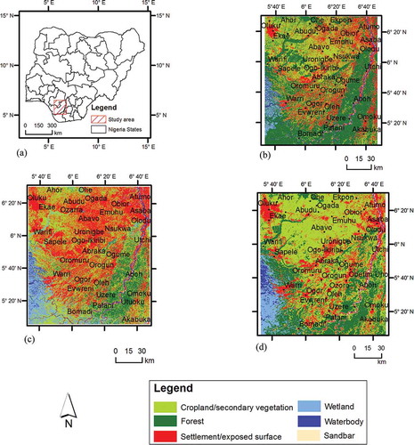
The Niger Delta region of Nigeria is situated along the Gulf of Guinea. It is the world’s third largest and Africa’s largest delta. It is also West and Central Africa’s most extensive wetland (Akegbejo-Samsons & Omoniyi, Citation2009). The region extends from Aboh (5°33′49″ N and 6°31′38″ E) in the north to palm point (4°16′22″ N and 6°05′27″ E) in the south. The east-west limit is between Benin River estuary (5°44′11″ N and 5°3′49″ E) in the west and Imo River estuary (4°27′16″ N and 7°35′27″ E) to the east (Niger Delta Environmental Survey (NDES), Citation1997) (see location in ). The region is endowed with a rich mosaic of fragile, sensitive and diverse ecosystems (Akegbejo-Samsons & Omoniyi, Citation2009; Fabiyi, Citation2011). NDDC (Citation2005) observed that the major ecological zones of the area include mangrove forest and coastal vegetation zone, freshwater swamp forest zone, lowland rainforest zone and the derived savannah zone found in the northern parts of the region.
Figure 1. (a) Location map of study area. (b) Land use categories, 1987. (c) Land use categories, 2002. (d) Land use categories, 2013.
Aspects of the geology and hydrology of the study area are reported by Short and Stauble (Citation1967) and Akpoborie (Citation2011), respectively. The rainfall pattern of the area is seasonal, characterised by wet season, which lasts between March and October in most parts of the region except in the coastal area where it rains all year round. The dry season begins in November and ends in February. A short dry season usually interrupts the wet season in late July or August. Mean annual rainfall ranges from about 4000 mm in the coastal areas to 1500 mm in the northern part of the region. Temperatures are generally high and relatively constant all year round. Average monthly maximum and minimum temperatures vary from 28°C to 38°C and from 21°C to 23°C, respectively (NDDC, Citation2005).
The primary economic activities in most of the rural communities in the study area include peasant farming, petty trading and fishing. Shifting cultivation (slash and burn), which involves cultivating a piece of land for a number of years and then abandoning it for a more fertile land, is traditionally practiced in the area. Some cash crops grown in the area include oil palm (Elaeis guineensis), cacao (Theobroma cacao), cassava (Manihot esculenta) and rubber (Hevea brasiliensis).
4.2. Data acquisition and analysis
Landsat images of 21 December 1987, 28 January 2002 and 10 January 2013, covering the study area, were obtained from the United States Geological Survey website on Earth Resources Observation and Science Center. At this period of the year, cloud cover effect is usually at its lowest. Similarly, errors resulting from seasonal differences are minimised since the images are acquired within the same season of the year and within a 1-month interval. The study area is covered by Landsat scene with world reference system Path/Row 189/056. A window containing 5747 × 4910 pixels was extracted from the scene covering the study area. The areal extent of the coverage is 22,920 km2 and the coordinates of the first corner of the window is defined by X = 1,18,185 and Y = 7,19,775. The area covers parts of Edo, Delta, Anambra, Bayelsa, Imo and Rivers states (). Image composite was obtained using the short wave channel 5, mid-infrared channel 4 and visible channel 2. Cohen and Goward (Citation2004) showed the importance of the shortwave infrared channels in characterising vegetation. Salami (Citation2000) noted the relevance of a combination of channel 4 (red), channel 5 (green) and channel 1 (blue) for vegetation studies. However, it was observed that a combination of channel 5 (red), channel 4 (green) and channel 2 (blue) was more effective in discriminating different vegetal cover types in the study area.
4.3. Image classification and accuracy assessment
The classification scheme developed by Adeniyi (Citation1985) is adopted in this study. However, there are settlements and exposed surfaces in the study area which were not identified in Adeniyi (Citation1985) classification scheme due to the study area used in that study. Similarly, cropland and secondary vegetation are merged into a single class. The exposed surface/settlement cover type consists of settlements, barren land and cleared forest. Visual image interpretation techniques of tone, shape, size, texture and pattern of features were used in identifying training sites for the purpose of supervised image classification. A minimum of 10 training sites was captured for each of the land cover types so as to improve classification accuracy. The minimum distance classification algorithm was used for supervised classification. The classes are settlement/exposed surface, cropland/secondary vegetation, wetland, water body, sandbar and natural forest. The natural forest includes matured forest with a dense canopy of 60% or more. The settlement/exposed surface category refers to cleared land, open space and bare surfaces, and urban or rural settlement. Cropland/secondary vegetation is cultivated or fallow farmland, while wetland includes swamps and waterlogged areas. Waterbody includes creeks, rivers, and streams, and sandbar is the sand deposit long rivers and streams. Field visits were conducted to validate the land use classes and Google Earth image was used in areas that were inaccessible or could not be visited during the field campaign. The confusion matrix (), which is described as the starting point for a variety of descriptive and analytical statistical techniques for accuracy assessment (Congalton, Citation1991), was generated using Idrisi software. The matrix presents a tabulated view of the accuracy level of the map and was also used in calculating the overall accuracy of the different land use classes individually and collectively.
Table 1. Error matrix.
Post-classification accuracy assessment of the data shows an overall accuracy of 93.4%, 92.8% and 96.4% in 1987, 2002 and 2013, respectively (). Congalton (Citation1991) and Liu, Frazier, and Kumar (Citation2007) noted that the overall accuracy assessment is perhaps the simplest and most commonly used descriptive statistical technique for measuring the classification accuracy of remote sensing data. It is computed by dividing the total correctly classified pixels by the total number of pixels in the confusion matrix (Congalton, Citation1991).
Table 2. Accuracy assessment.
The processes of deforestation were evaluated using the land use maps derived from supervised classification for each land use/cover. The result obtained from this process is divided by the number of years between the land use/cover maps (1987–2013) to arrive at the annual rate of change.
5. Results
The land use/cover maps of the study area for 1987, 2002 and 2013 (–) show the pattern of deforestation. The figures reveal that forest was more visible in the southern and southeastern portions of the study area. The southern part of the study area is majorly made up of the mangrove forest, which is common in the creeks of the Niger Delta region of Nigeria, particularly around settlements such as Bomadi, Patani, Otuoke and Warri areas. The southeastern part of the study area, however, is composed of the Niger forest reserve. This area is surrounded by settlements including Aboh, Ossissa and Ndoni among others. Forest in the western part of the study area is seen majorly along the Osiomo River and in some forest enclaves in Sakponba area near Benin city. Areas around Igueben reserve also show dense forest vegetation.
–, however, shows that the forest continued to decline over the years. This decline is most visible in the northeastern portion of the study area along the Niger River where settlement and agriculture have encroached into the forest. Most of the forest in this area has been converted to cropland and secondary vegetation. A close observation of – reveals that the major urban centres in the region such as Aba, Asaba, Agbor, Benin city, Onitsha and Warri expanded significantly during the period under study taking up secondary vegetation and cropland in the process. The wetland in the southwestern part of the study area is observed to be expanding while water body is declining. Sandbar along the Niger River is also increasing. Apart from the activities of some oil prospecting companies, it appears that human activities in the wetland area are limited.
The pattern of change in land use/cover type is shown in and . indicates that the rate of wetland change consistently increased between 1987 and 2013. The table shows that wetland was 633 km2 in 1987, 782 km2 in 2002 and 971 km2 in 2013. This shows an increase of 23.5% (0.02% per year) between 1987 and 2002 and 24.2% (0.05% per year) between 2002 and 2013. The average rate of change for the entire 26-year period was observed to be 0.02% per year. Similarly, exposed surface/settlement was 2498 km2 in 1987, 6011 km2 in 2002 and 3463 km2 in 2013, while cropland/secondary vegetation was 9796 km2 in 1987, 8740 km2 in 2002 and 13140 km2 in 2013. This shows that exposed surface/settlement is increasing at a decreasing rate. It is, however, increasing at a rate above average. Cropland/secondary vegetation on the other hand lost at the rate of 0.01% per year between 1987 and 2002. It, however, gained between 2002 and 2013 at an average rate of 0.03% per year. Similarly, sandbar showed a consistent rise in the rate of increase between 1987 and 2013. It gained an average of 0.02% per year between 1987 and 2002 and 0.14% per year between 2002 and 2013.
Table 3. Land use/cover gain/loss analysis.
Figure 2. Land use/cover gain/loss between 1987 and 2013.
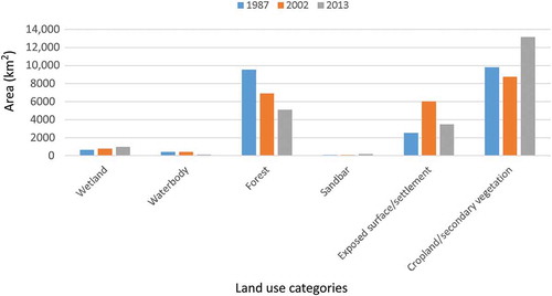
Water body and forest categories declined during the period of this study. The area occupied by water reduced from 408 km2 in 1987 to 402 km2 in 2002. The rate of loss observed for water body was 0.07% per year between 2002 and 2013. This value is greater than the average rate for the entire period of the study, which was 0.03% per year. Similarly, forest declined by 2621 km2 between 1987 and 2002, a rate equal to the average for the entire period of study (0.02% per year). However, the rate of forest loss increased to 0.04% per year between 2002 and 2013.
6. Discussion
The consequences of tropical deforestation are of major concern to scientists, conservationists and decision-makers. This concern has resulted in several initiatives and projects aimed at providing a better understanding of the processes of deforestation (Angelsen & Kaimowitz, Citation1999; Lambin et al., Citation2000). Though there was a decrease in the rate of gain in exposed surface/settlement category between 2002 and 2013, the average rate of change was higher than the average for the period of study. The reduction in the rate of change may be because of a decrease in land preparation for cultivation because of rural urban migration in search of alternative economic opportunities. Lambin et al. (Citation2001) have noted that peoples’ response to economic opportunities influence land use change. The overall high rate of growth in the exposed surface/settlement category could, however, be because of rapid population increase, worsening economic conditions and rapid urban expansion, which lead to an increase in demand for food production and other ecological goods and services (Jande & Nsofor, Citation2004). This therefore seems to suggest that the pattern of deforestation in the Niger Delta region may largely be driven by urban development and agricultural activities. Fabiyi (Citation2011) arrived at a similar conclusion in his study of the influence of change actors’ on land use and land cover change pattern in the Niger Delta region of Nigeria. Armenteras et al. (Citation2006) also noted that deforestation in the Colombian Amazon is related to factors such as land use history, environmental and social economic factors such as oil extraction, cattle ranching or illegal cropping. Furthermore, the result is similar to results obtained in the northern part of Nigeria where an overall increase in bare surface was reported (Adeniyi & Omojola, Citation1999; Eniolorunda & Bello, Citation2011). The need for food production may also explain the increased rate of change in cropland/secondary vegetation. The need for arable land may have resulted in the observed increase in the rate of forest loss and degradation between 2002 and 2013.
The increasing rate of deforestation in the Niger Delta can also be attributed to increasing demand for arable land for food production occasioned by increase in population. Armenteras et al. (Citation2006) and Eniolorunda and Bello (Citation2011) also reported high deforestation rates in the Colombian Amazon and Tangaza forest reserve in northwestern Nigeria, respectively. The demand for food resulting from population increase and the lack of alternative sources of income, coupled with an increase in the poverty level in the Niger Delta region, is likely to exert more pressure on the forest and forest resources in the region. The high rate of deforestation in the Niger Delta, particularly the rapid decline in mangrove and natural forest, may cause a reduction in biodiversity and a high level of carbon emission. Though FAO (Citation2005) reported a declining rate of mangrove forest depletion in the Niger Delta between the 1980s and the 1990s, the result of this study shows an increasing rate of change in wetland and swamp in the study area. This increase, however, seems to be closely related to the reduction in the areal extent of waterbody, which has also resulted in an increase in rate of sand deposited along the Niger River. Apart from the decline in vegetation diversity caused by forest loss, wildlife and marine animals are also threatened by rapid environmental changes, particularly in mangrove and wetland ecosystem. These changes also have implications for food security and supply of forest goods and services as fertile agricultural land is lost to rapid urban expansion and infrastructure development. Similarly, local industries such as wood industries and other industries that depend on forest products are forced to source for raw materials in more distant areas, which leads to an increase in the cost of production.
Lambin et al. (Citation2003) posited that there is a low rate of forest loss in Africa and South-East Asia. It, however, appears that this is not the case in the Niger Delta region. The result of this study reveals an increasing rate of deforestation in the Niger Delta. The increasing rate of deforestation appears to be because of an increase in human footprint in the area occasioned by an increase in population and urban expansion. The rate of deforestation in the area between 2002 and 2013 is higher than the average rate of change for the entire period of the study.
The increase in deforestation also implies an increased in the rate of biodiversity loss and an increase in the rate at which forest goods and services are lost in the Niger Delta region. Forest managers, conservationist, environmentalists, decision-makers and other stakeholders must therefore evolve strategies that will slow down the rate of deforestation in the region. Uncontrolled timber harvesting, clearing and cultivation of forest reserves and unplanned urban expansion must be checked. There is also the need to promote the adoption of intensive agriculture by providing farming input that will encourage farmers to cultivate the same piece of land for a long period without the need to abandon it for a more fertile land. This will slow down the rate of forest conversion to other land uses. Similarly, policies aimed at restricting the indiscriminate clearing of forest clearing and bush burning should be formulated and enforced. In the same vein, the forest needs to be closely monitored to identify ‘deforestation hot spots’ that need more intense and strategic management approaches that will ensure sustainable use of the available forest resources in the region.
7. Conclusion
The study has shown that the Niger Delta region has undergone changes in the recent past, majorly because of human activities. Urban development and agricultural activities seem to play an important role in land use/cover change in the region, resulting in a high rate of forest loss and degradation. The increasing rate of forest disturbance observed in the region requires urgent intervention from forest managers and decision-makers in order to check the increase in forest loss, which also leads to loss of biodiversity in the Niger Delta. In addition, farmers should be encouraged to practice intensive agriculture.
It is hoped that the result of this work will serve as guide to natural resource managers in evaluating the pattern of deforestation. This will serve as a basis for formulating policies aimed at mitigating forest loss, and by extension, biodiversity loss, in the Niger Delta region. Furthermore, Geographic Information Systems, which provides a tool for creating and evaluating scenarios as well as projecting into the future during the planning process, should be used in natural resources assessment and monitoring.
References
- Adeniyi, P. O. (1985). Digital analysis of multitemporal Landsat data for land-use/land-cover classification in a semi-arid area of Nigeria. Photogrammetric Engineering and Remote Sensing, 51, 1761–1774.
- Adeniyi, P. O., & Omojola, A. (1999). Land use/land cover change evaluation in Sokoto-Rima Basin of N.W. Nigeria based on archival remote sensing and GIS techniques. In P. O. Adeniyi (Ed.), Geoinformation technology application for resource and environmental management in Africa (pp. 143–172). Lagos: AARSE.
- Adepoju, M. O., Millington, A. C., & Tansey, K. T. (2006, May 1–5). Land use/land cover change detection in metropolitan Lagos (Nigeria): 1984–2002. 2006 Annual Conference of ASPRS, Reno, NV.
- Agarwal, D. K., Silander, J. A., Gelfand, A. E., Dewar, R. E., & Mickelson, J. G. (2005). Tropical deforestation in Madagascar: Analysis using hierarchical, spatially explicit, Bayesian regression models. Ecological Modelling, 185, 105–131. doi:10.1016/j.ecolmodel.2004.11.023
- Akegbejo-Samsons, Y., & Omoniyi, I. T. (2009). Management challenges of mangrove forests in Africa: A critical appraisal of the coastal mangrove ecosystem of Nigeria. Nature and Faune, 24, 50–55.
- Akinyemi, F. O. (2013). An assessment of land-use change in the cocoa belt of south-west Nigeria. International Journal of Remote Sensing, 34, 2858–2875. doi:10.1080/01431161.2012.753167
- Akpoborie, I. A. (2011). Aspects of the hydrology of the western Niger Delta wetlands: Groundwater conditions in the Neogene (recent) deposits of the Ndokwa area. In Proceedings of the environmental management conference, (pp. 334–349). Abeokuta: Federal University of Agriculture.
- Angelsen, A., & Kaimowitz, D. (1999). Rethinking the causes of deforestation: Lessons from economic models. The World Bank Research Observer, 14, 73–98. doi:10.1093/wbro/14.1.73
- Armenteras, D., Rudas, G., Rodriguez, N., Sua, S., & Romero, M. (2006). Patterns and causes of deforestation in the Colombian Amazon. Ecological Indicators, 6, 353–368. doi:10.1016/j.ecolind.2005.03.014
- Aweto, A. O. (1990). Plantation forestry and forest conservation in Nigeria. Environmentalist, 10, 127–134. doi:10.1007/BF02244389
- Azeez, I. O., Ikponmwonba, O. S., Popoola, L., & Amusa, T. O. (2010). Land use activities among forest environments’ dwellers in Edo State, Nigeria: Implications for livelihood and sustainable forest management. International Journal of Social Forestry, 3, 164–187.
- Balogun, I. A., Adeyewa, D. Z., Balogun, A. A., & Morakinyo, T. E. (2011). Analysis of urban expansion and land use change in Akure, Nigeria using remote sensing and geographic information system (GIS) techniques. Journal of Geography and Regional Planning, 4, 533–541.
- Bawa, K. S., & Seidler, R. (1998). Natural forest management and conservation of biodiversity in tropical forests. Conservation Biology, 12, 46–55. doi:10.1046/j.1523-1739.1998.96480.x
- Cohen, W. B., & Goward, S. N. (2004). Landsat’s role in ecological applications of remote sensing. BioScience, 54, 535–545. doi:10.1641/0006-3568(2004)054[0535:LRIEAO]2.0.CO;2
- Congalton, R. G. (1991). A review of assessing the accuracy of classifications of remotely sensed data. Remote Sensing of Environment, 37, 35–46. doi:10.1016/0034-4257(91)90048-B
- Darwin, R., Tsigas, M., Lewandrowski, J., & Raneses, A. (1996). Land use and cover in ecological economics. Ecological Economics, 17, 157–181. doi:10.1016/S0921-8009(96)80004-8
- Effiong, J. (2011). Changing pattern of land use in the Calabar river catchment, southeastern Nigeria. Journal of Sustainable Development, 4, 92–102.
- Enaruvbe, G. O., & Ige-Olumide, O. (2014). Geospatial analysis of land-use change processes in a densely populated coastal city: The case of Port Harcourt, south-east Nigeria. Geocarto International. Advance online publication. doi:10.1080/10106049.2014.883435
- Eniolorunda, N. B., & Bello, A. G. (2011). Forest cover change assessment of Tangaza forest reserve, north-west of Sokoto State, Nigeria. Ife Research Publications in Geography, 10, 66–74.
- Etter, A., McAlpine, C., Phinn, S., Pullar, D., & Possingham, H. (2006). Characterizing a tropical deforestation wave: A dynamic spatial analysis of a deforestation hotspot in the Colombian Amazon. Global Change Biology, 12, 1409–1420. doi:10.1111/j.1365-2486.2006.01168.x
- Etter, A., McAlpine, C., Wilson, K., Phinn, S., & Possingham, H. (2006). Regional patterns of agricultural land use and deforestation in Colombia. Agriculture, Ecosystems & Environment, 114, 369–386. doi:10.1016/j.agee.2005.11.013
- Fabiyi, O. O. (2006). Urban land use change analysis of a traditional city from remote sensing data: The case of Ibadan metropolitan area, Nigeria. Human & Social Sciences Journal, 1, 42–64.
- Fabiyi, O. O. (2011). Change actors’ analysis and vegetation loss from remote sensing data in parts of the Niger Delta region. Journal of Ecology and the Natural Environment, 3, 381–391.
- Fanah, U., Dlama, K. I., & Oluseyi, I. O. (2011). Urban expansion and vegetal cover loss in and around Nigeria’s Federal Capital City. Journal of Ecology and the Natural Environment, 3, 1–10.
- FAO. (2000). Global forest resources assessment 2000 (FAO Forestry Paper 140). Rome: Author.
- FAO. (2005). Global forest resources assessment 2005: Thematic study on mangrove, Nigeria. Rome: Author.
- Geist, H. J., & Lambin, E. F. (2002). Proximate causes and underlying driving forces of tropical deforestation. BioScience, 52, 143–150. doi:10.1641/0006-3568(2002)052[0143:PCAUDF]2.0.CO;2
- Geist, H. J., & Lambin, E. F. (2004). Dynamic causal patterns of desertification. BioScience, 54, 817–829. doi:10.1641/0006-3568(2004)054[0817:DCPOD]2.0.CO;2
- Gobin, A., Campling, P., & Feyen, J. (2002). Logistic modelling to derive agricultural land use determinants: A case study from southeastern Nigeria. Agriculture, Ecosystems and Environment, 89, 213–228. doi:10.1016/S0167-8809(01)00163-3
- Goldewijk, K. K., & Ramankutty, N. (2004). Land cover change over the last three centuries due to human activities: The availability of new global data sets. GeoJournal, 61, 335–344. doi:10.1007/s10708-004-5050-z
- Ickowitz, A. (2006). Shifting cultivation and deforestation in tropical Africa: Critical reflections. Development and Change, 37, 599–626. doi:10.1111/j.0012-155X.2006.00492.x
- Irwin, E. G., & Geoghegan, J. (2001). Theory, data, methods: Developing spatially explicit economic models of land use change. Agriculture, Ecosystems & Environment, 85, 7–24. doi:10.1016/S0167-8809(01)00200-6
- Jande, J. A., & Nsofor, G. N. (2004). Assessment of vegetation degradation in Makurdi area and its environs using remotely sensed data. In O. O. Ayeni, P. C. Nwilo, A. Omojola, & J. B. Olaleye (Eds.), Geoinformation for sustainable development in Africa (pp. 299–306). Lagos: AARSE.
- Kaimowitz, D., Mendez, P., Puntodewo, A., & Vanclay, J. (2002). Spatial regression analysis of deforestation in Santa Cruz, Bolivia. In C. H. Wood & R. Porro (Eds.), Land use and deforestation in the Amazon (pp. 41–65). Gainesville, FL: University Press.
- Lambin, E. F. (1997). Modelling and monitoring land-cover change processes in tropical regions. Progress in Physical Geography, 21, 375–393. doi:10.1177/030913339702100303
- Lambin, E. F. (1999). Monitoring forest degradation in tropical regions by remote sensing: Some methodological issues. Global Ecology and Biogeography, 8, 191–198. doi:10.1046/j.1365-2699.1999.00123.x
- Lambin, E. F., Geist, H. J., & Lepers, E. (2003). Dynamics of land-use and land-cover change in tropical regions. Annual Review of Environment and Resources, 28, 205–241. doi:10.1146/annurev.energy.28.050302.105459
- Lambin, E. F., Rounsevell, M. D. A., & Geist, H. J. (2000). Are agricultural land-use models able to predict changes in land-use intensity? Agriculture, Ecosystems and Environment, 82, 321–331. doi:10.1016/S0167-8809(00)00235-8
- Lambin, E. F., Turner, B. L., Geist, H. J., Agbola, S. B., Angelsen, A. A., Bruce, J. W., … Xu, J. (2001). The causes of land-use and land-cover change: Moving beyond the myths. Global Environmental Change, 11, 261–269. doi:10.1016/S0959-3780(01)00007-3
- Linkie, M., Smith, R. J., & Leader-Williams, N. (2004). Mapping and predicting deforestation patterns in the lowlands of Sumatra. Biodiversity and Conservation, 13, 1809–1818. doi:10.1023/B:BIOC.0000035867.90891.ea
- Liu, C., Frazier, P., & Kumar, L. (2007). Comparative assessment of the measures of thematic classification accuracy. Remote Sensing of Environment, 107, 606–616. doi:10.1016/j.rse.2006.10.010
- Ludeke, A. K., Maggio, R. C., & Reid, L. M. (1990). An analysis of anthropogenic deforestation using logistic regression and GIS. Journal of Environmental Management, 31, 247–259. doi:10.1016/S0301-4797(05)80038-6
- Mahmud, A., & Achide, A. S. (2012). Analysis of land use/land cover changes to monitor urban sprawl in Keffi-Nigeria. Environmental Research Journal, 6, 129–134.
- Mengistu, D. A., & Salami, A. T. (2007). Application of remote sensing and GIS in land use/ land cover mapping and change detection in a part of south western Nigeria. African Journal of Environmental Science and Technology, 5, 99–109.
- Mertens, B., Sunderlin, W. D., Ndoye, O., & Lambin, E. F. (2000). Impact of macroeconomic change on deforestation in South Cameroon: Integration of household survey and remotely-sensed data. World Development, 28, 983–999. doi:10.1016/S0305-750X(00)00007-3
- Mmon, P. C., & Arokoyu, S. B. (2010). Mangrove forest depletion, biodiversity loss and traditional resources management practices in the Niger Delta, Nigeria. Research Journal of Applied Sciences, Engineering and Technology, 2, 28–34.
- NDDC. (2005). Niger Delta regional development master plan. Port Harcourt: Author.
- Niger Delta Environmental Survey (NDES). (1997). Environmental and socio-economic characteristics. Port Harcourt: NDDC.
- Njike, C., Igbokwe, J. I., & Orisakwe, K. U. (2011). Analysis of landuse and landcover changes of Aba Urban using medium resolution satellite imageries. FIG working week 2011: Bridging the gap between cultures, Marrakech, Morocco.
- Obiefuna, J. N., Idris, S. O., & Uduma-Olugu, N. (2011). An assessment of the changes in the landscape of Ogudu-Oworonshoki development prone area of Lagos Metropolis, Nigeria. Journal of Sustainable Development, 4. doi:10.5539/jsd.v4n5p82
- Ogbuene, E. B. (2010). Environmental consequences of rainfall variability and deforestation in southeastern Nigeria. International Journal of Water and Soil Resources Research, 1, 100–115.
- Ogunleye, A. J., Adeola, A. O., Ojo, L. O., & Aduradola, A. M. (2004). Impact of farming activities on vegetation in Olokemeji forest reserve, Nigeria. International Journal of Global Nest, 6, 131–140.
- Onuche, U. (2010). Impact of poverty on the sustainability of forests in Nigeria: Implication for sustainable forests and reduction in global warming. Journal of Sustainable Development in Africa, 12, 208–215.
- Phillips, O. L. (1997). The changing ecology of tropical forests. Biodiversity and Conservation, 6, 291–311. doi:10.1023/A:1018352405482
- Read, J. M., & Lam, -N. S.-N. (2002). Spatial methods for characterising land cover and detecting land cover changes for the tropics. International Journal of Remote Sensing, 23, 2457–2474. doi:10.1080/01431160110106140
- Rolfe, J., Bennett, J., & Louviere, J. (2000). Choice modelling and its potential application to tropical rainforest preservation. Ecological Economics, 35, 289–302. doi:10.1016/S0921-8009(00)00201-9
- Salami, A. T. (1999). Vegetation dynamics on the fringes of lowland humid tropical rainforest of south-western Nigeria an assessment of environmental change with air photos and Landsat TM. International Journal of Remote Sensing, 20, 1169–1181. doi:10.1080/014311699212920
- Salami, A. T. (2000). Vegetation mapping of a part of dry tropical rainforest of southern Nigeria from Landsat TM. International Archives of Photogrammetry and Remote Sensing, XXXIII, 1301–1308.
- Serneels, S., & Lambin, E. F. (2001). Proximate causes of land-use change in Narok District, Kenya: A spatial statistical model. Agriculture, Ecosystems & Environment, 85, 65–81. doi:10.1016/S0167-8809(01)00188-8
- Serneels, S., Said, M. Y., & Lambin, E. F. (2001). Land cover changes around a major east African wildlife reserve: The Mara ecosystem (Kenya). International Journal of Remote Sensing, 22, 3397–3420. doi:10.1080/01431160152609236
- Short, K. C., & Stauble, A. J. (1967). Outline geology of Niger Delta. AAPG Bulletin, 51, 761–779.
- Skole, D., & Tucker, C. (1993). Tropical deforestation and habitat fragmentation in the Amazon: Satellite data from 1978 to 1988. Science, 260, 1905–1910. doi:10.1126/science.260.5116.1905
- Sun, H., Forsythe, W., & Waters, N. (2007). Modeling urban land use change and urban sprawl: Calgary, Alberta, Canada. Networks and Spatial Economics, 7, 353–376. doi:10.1007/s11067-007-9030-y
- Terborgh, J. (2000). The fate of tropical forests: A matter of stewardship. Conservation Biology, 14, 1358–1361. doi:10.1046/j.1523-1739.2000.00136.x
- Turner II, B. L., Villar, S. C., Foster, D., Geoghegan, J., Keys, E., Klepeis, P., … Vance, C. (2001). Deforestation in southern Yucatan peninsular region: An integrative approach. Forest Ecology and Management, 154, 353–370. doi:10.1016/S0378-1127(01)00508-4
- Veldkamp, A., & Lambin, E. F. (2001). Predicting land-use change. Agriculture, Ecosystems & Environment, 85, 1–6. doi:10.1016/S0167-8809(01)00199-2
- Verburg, P. H., De Koning, G. H. J., Kok, K., Veldkamp, A., & Bouma, J. (1999). A spatial explicit allocation procedure for modelling the pattern of land use change based upon actual land use. Ecological Modelling, 116, 45–61. doi:10.1016/S0304-3800(98)00156-2
- Verburg, P. H., Schot, P., Dijst, M., & Veldkamp, A. (2004). Land use change modelling: Current practice and research priorities. GeoJournal, 61, 309–324. doi:10.1007/s10708-004-4946-y
- Wilcove, D. S., McLellan, C. H., & Dobson, A. P. (1986). Habitat fragmentation in the temperate zone. In M. E. Soule (Ed.), Conservation biology: The science of scarcity and diversity (pp. 237–256). Sunderland: Sinauer Associates.
- Wilcox, B. A., & Murphy, D. D. (1985). Conservation strategy: The effects of fragmentation on extinction. The American Naturalist, 125, 879–887. doi:10.1086/284386
- Yiridoe, E. K., & Nanang, D. M. (2001, August 5–8). An econometric analysis of the causes of tropical deforestation: Ghana. American Agricultural Economics Association Conference, Chicago, IL.
- Zipperer, W. C. (1993). Deforestation patterns and their effects on forest patches. Landscape Ecology, 8, 177–184. doi:10.1007/BF00125349