
ABSTRACT
Climate change and a rapidly growing human population have put ever greater strains on the global food system. Although the number of food insecure people in the world has reached a record low, changing land use and climate variability will threaten our ability to maintain this progress. Profound changes in the structure of economies around the world have affected agricultural production and how food is delivered to the consumer. This paper explores connections between land use, environmental change and food availability, access, and utilization. Each of these elements of food security has vulnerabilities to changing environmental conditions and land use that can be explored using satellite remote sensing observations. Technology is a key way environmental changes can be quantified and used in food security assessment.
1 Introduction
Climate change and a rapidly growing human population have put ever greater strains on the global food system. Although the number of food insecure people in 2015 reached a record low (FAO, Citation2015), more than half of the world’s population is still classified as low income and vulnerable to changes in food availability and cost (Kochhar, Citation2015). Overproduction of basic commodities due to agriculture subsidies (Rosegrant, Msangi, Sulser, & Valmonte-Santos, Citation2006), falling nutrient diversity in the food that is available (Remans, Wood, Saha, Anderman, & DeFries, Citation2015), rising incomes, and widespread adoption of ‘western’ diets rich in meat and dairy products (Popkin, Citation2004) will increase the demand for more agricultural production in coming decades (United Nations, Citation2015). Globalization and climate change are transforming the geography of food systems in a way that is altering the distribution of land and water supplies, shifting the environmental burden of food production to new areas (MacDonald et al., Citation2015). In this context, the world needs to double the amount of food it produces in the next 40 years to ensure sufficient food for all (IAASTD, Citation2008).
Land use is a key underlying aspect of all food systems that enables food security (Foley et al., Citation2005; Vermeulen, Campbell, & Ingram, Citation2012). The World Food Summit of 1996 defined food security as existing ‘when all people at all times have access to sufficient, safe, nutritious food to maintain a healthy and active life’ (FAO, Citation1996). Although agriculture is the starting place for all food production, changes in other aspects of the food system are also profoundly affected by environmental and land use change. Food systems are activities whose ultimate goal is individual food consumption, including producing, processing, packaging, distributing, transporting, refrigerating, retailing, preparing, and consuming food.
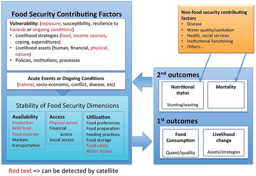
Remote sensing data can provide direct and indirect information about the vulnerability of households to factors that would increase their food insecurity, including food and income sources that support their livelihood, physical and natural sources of livelihood assets, and their exposure to hazards or ongoing conditions that affect food production (). It can be used directly to assess changes in food production, understand proximity of vulnerable households to markets and to natural areas that may provide wild foods, and access to safe food and water. The stability of food security dimensions result in changes in food security outcomes, which include food consumption, changes in livelihood and ultimately in stunting, wasting, and mortality. In this paper, I show how remote sensing information can be used to understand the elements of food security and to assess the probability of negative food security outcomes for communities.
Figure 1. Conceptual diagram showing how the context and contributing factors connects the stability of food availability, access, and utilization to food security outcomes. Red parameters can be seen using remote sensing information. Derived from IPC (Citation2012).
1.1 Food security
Food security is defined by three interrelated concepts or pillars that must all be present consistently throughout the year in order for an individual, household, or community to be food secure:
Food availability or the existence of food at a particular place and time as provided through production or trade;
Food access or the ability of a person or group to obtain food through purchase, barter, or trade; and
Food utilization or the ability to use and obtain nourishment from food, including the food’s nutritional value and how the body assimilates nutrients (Brown et al., Citation2015).
Despite an increase in average global yields of about 1.8% per year since 2000, resulting in approximately 20% more cereals being produced in 2015 (FAO, Citation2016b), there are still food insecure people in every country. Food security today is caused by problems of distribution and access to food by the poorest people in both urban and rural regions, in rich and poor countries. In addition to failing to provide for extremely poor people, the food system is also causing an increasing number of people to become overweight and obese (Flegal, Kit, Orpana, & Graubard, Citation2013; Jaacks, Slining, & Popkin, Citation2015). Industrially produced food, reductions in the time cost of food, urban lifestyles, and lack of sufficient exercise have resulted in large increases in the proportion of the global population who are obese, causing health problems for both the rich and the poor (Swinburn et al., Citation2011). Both under and overnutrition are a result of our food systems’ characteristics (Brown et al., Citation2015).
Lack of food access is caused by the cost of food being greater than the available disposable income of an individual or family (Brown et al., Citation2015; Konandreas, Citation2012; VerPloeg et al., Citation2012). The variability of local food prices is extremely important to the food security of the very poor, particularly when local prices change rapidly over short periods (Bellemare, Citation2015; Brown et al., Citation2012). Rapid changes in food affordability affect human well-being by increasing poverty, reducing educational attainment, affecting health services, and reducing the productive assets held by the poor (Grosh, Ninno, Tesliuc, & Ouerghi, Citation2008).
A major threat to food security is long-term environmental change and extreme events (Field et al., Citation2012; Hatfield & Prueger, Citation2015), including agriculturally relevant weather extremes such as droughts (Enenkel et al., Citation2015), floods (Kenyon, Hill, & Shannon, Citation2008), and widespread changes in land use and land cover (Flora, Citation2010; Vermeulen, Aggarwal, et al., 2012) that increase or change the kinds of food produced. Climate change is likely to affect not only food production but also significant portions of the existing food system in coming years (Brown et al., Citation2015).
Documenting changes in the environment requires a calibrated, comparable, multi-decade data record that is largely only available in countries with a high level of economic development. Satellite remote sensing data are often the only data that are available for all regions and over long periods which can be used to inform food security assessment and analyses (DeFries et al., Citation2007). Here, I focus on the regions that are most food insecure in Africa (FAO, Citation2015) and do not discuss food security in the developed countries, where changes in employment is the primary cause of food insecurity (Brown et al., Citation2015).
1.2 Remote sensing for food security assessment
Satellite remote sensing, or the science of obtaining information about objects or areas from a distance, is a key tool to analyze short- and long-term changes in ecosystem functioning, land use, and agricultural development (Jensen, Citation2006). Remote sensing is often the earliest indicator of an impending food security problem, as it can provide decision makers with estimates in food production in vulnerable regions, months before final statistics are available (Brown, Funk, Galu, & Choularton, Citation2007). It is also reliable and comparable across regions and cultures, making it a substantial focus of early warning programs such as the US Agency for International Development’s Famine Early Warning Systems Network (FEWS NET). Because early warning programs now seek to estimate changes in food security in the coming 3 months instead of the past, it is an important aspect of their analytical process.
shows the three food security components and how satellite remote sensing can be used to assess changes that are relevant to assessment. There are elements in that do not have relevant observations from remote sensing, but even for these there is usually a way to assess the context in which the parameter is changing (). For example, if economic access has changed due to rising food prices, the community can estimate the probability that local food stocks are sufficient by estimating production in the previous year. We can estimate changes in utilization due to unusual events such as rainfall during the dry season that may cause unsafe fungal growth in yet-to-be harvested crops or in grain that is stored outside before being sold. These indirect observations of food security help determine overall food security outcomes in an area.
Table 1. Food security components and the remote sensing observations that can be used to derive them.
The three pillars of food security overlap in analytical content and are influenced by each other and the context in which the analysis occurs. For example, widespread reductions in rainfall may also affect food access due to reductions in wage labor income (Reardon, Citation1997) and increase food prices (Brown, Citation2014), as well as reduce food safety and thus food utilization due to increases in the availability of contaminated food in the market (Magan, Hope, Cairns, & Aldred, Citation2003; Tirado, Clarke, Jaykus, McQuatters-Gollop, & Frank, Citation2010). Geographic proximity to urban centers and to culturally relevant borders and power centers can be identified using satellite data, although interpretation and relevance to household food security must be provided by social and political analysis (Antwi-Agyei, Fraser, Dougill, Stringer, & Simelton, Citation2012; Jarosz, Citation2014; Shepherd et al., Citation2013; Wesenbeeck, Keyzer, & Nube, Citation2009). Below, I explore the role land use and remote sensing information plays in each remote sensing pillar, expanding upon these ideas. I use examples in sub-Saharan Africa to illustrate how remote sensing data can be used to identify food insecurity through context-specific analysis of change in the three pillars of food security: availability (Section 2), access (Section 3), and utilization (Section 4).
2 Remote sensing for agricultural monitoring
Agriculture is a major land use, taking up almost half the Earth’s land if you include both crop and livestock production (Ramankutty, Evan, Monfreda, & Foley, Citation2008). Analyzing how much food will be produced in any 1 year includes analysis of the amount of land in cultivation as well as the yield obtained on those areas (Fritz et al., Citation2015). Conversion of land cover from forest or savanna to crop land will increase overall food production in an area, but by how much is determined by the productivity of the land and how it is managed (Deryng, Sacks, Barford, & Ramankutty, Citation2011). Brink and Eva (Citation2009), for example, showed that from 1975 to 2000 agriculture in sub-Saharan Africa has expanded by 57% over the expense of natural vegetation, with a loss of nearly 5 million hectares of forest and non-forest during the period. The increase in the amount of food grown per capita, however, has not increased due to stagnation in yield growth during the period (FAO, Citation2015).
2.1 Remote sensing of yield and cropped area
The world’s poorest people rely on grains to survive (FAO, Citation2015). Thus, food security analysis often focuses on estimating interannual changes in the amount of food produced in a country, particularly as input into food balance estimates (Mwila, Banda, & Kabwe, Citation2004). Food production is measured by the estimation of the amount of a crop grown per unit area in cultivation, or production = yield × cropped area. Both parameters can be estimated using remote sensing, but analysis of yield is more common given the abundance of high temporal frequency moderate and coarse resolution data suitable for yield estimation, and the relative difficulty of obtaining sufficient very high resolution and ground data necessary to estimate cropped area.
Coarse resolution data from the advanced very high resolution radiometer from 1981 and the moderate resolution imaging spectroradiometer (MODIS) on board the Earth Observing System Terra satellite from 2000 can be used to monitor changes in agricultural yield in both labor- and capital-intensive agricultural systems due to the weather (Brown & Mata, Citation2016). Operational, satellite-derived rainfall datasets such as National Oceanic and Atmospheric Administration’s Rainfall Estimate and the Climate Hazard Infrared Precipitation data with Stations (CHIRPS) are widely used in food security analyses and crop monitoring (Davies et al., Citation2015; Funk, Peterson, et al., 2015). Satellite data provide daily images of the globe and are able to measure rainfall, vegetation, and land surface temperature conditions resulting from abnormally wet, dry, or cold weather. These data are used in a number of operational systems that support global markets and the process through which commodity prices are determined, such as the Global Agriculture Monitoring Project (Becker-Reshef et al., Citation2010). Monitoring systems enable timely, easily accessible information about rapidly changing global crop conditions that ensure transparency in information about the global food supply.
To estimate cropped area, moderate resolution imagery from Landsat and the Sentinel satellites, as well as high-resolution imagery from WorldView, Ikonos and others can be used to identify the amount of land in cultivation in any year (Smith, Tappan, Husak, & Crane, Citation2006). Short-term changes in land use that have an impact on food production, such as an expansion or contraction of land in cultivation, need to be examined at the same time as the impact of moisture conditions on yield to estimate overall productivity () (Grace, Husak, Harrison, Pedreros, & Michaelsen, Citation2012; Husak et al., Citation2008). The amount of food grown locally has a significant impact on the food security of both the farmers who rely upon sales of extra grain for income, as well as for local urban areas who consume it (FAO, Citation2012a).
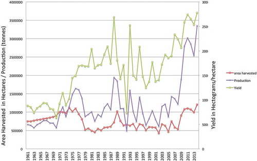
Figure 2. Maize production, cropped area in hectares, and yield in hectograms/hectare in Zambia, UN Food and Agriculture country statistics from the FAO statistics database (FAO, Citation2016b).
Although food availability depends on food production, achieving food security requires that each individual has access to the food that is available, and that he or she is healthy enough to be able to use the food that is consumed. Just because there is food in stores for purchase does not mean that the poorest households will have access to it (Devereux, Citation1988; Sen, Citation1990). Livelihoods and entitlements can be affected by both economic transformations and environmental change over time (Seaman, Citation2000; Teklu, Citation1991). How technology is used to examine these changes is an evolving field, and one based in exploring the environment–economic relationships embedded in food security outcomes (McCusker & Carr, Citation2006; Munroe, McSweeney, Olson, & Mansfield, Citation2014). By using data to develop new methodologies that focus on different aspects of food security, the research community can better explore how land use and land cover change affect the lives and livelihoods of the most vulnerable populations.
2.2 Remote sensing approaches for estimating changes in food availability
Food availability addresses the question of whether there is sufficient food locally for all people who live in the area. The amount of food produced is the foundation upon which food security rests, particularly in rural regions where agriculture is the dominant source of livelihoods. Other aspects of the food system also affect food availability, including food imports, food stored from previous seasons, and removal of food from the system through export and conversion into nonfood products such as alcohol or animal feed (Brown et al., Citation2015). Remote sensing is a critical tool that is commonly used to estimate local food production, but the information needs to be analyzed with a focus on the context in which the production occurs (Verdin, Funk, Senay, & Choularton, Citation2005).
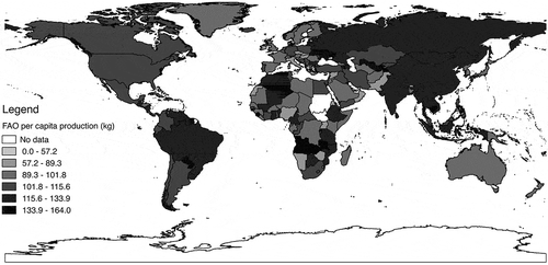
Agriculture is a critical part of the economies of many developing countries. Smallholder farmers who produce over 75% of agricultural output often dominate the agriculture sector of these countries, but their productivity is held back by low yields, lack of integrated markets, agricultural credit, and technology access (Tittonell & Giller, Citation2013). shows a map of the Food and Agriculture Organization (FAO) 2013 per capita agricultural production. Regions with the lowest average yields also have the highest poverty rates and economies most dependent on agriculture.
Figure 3. Map of FAO per capita food production by country for 2013 (FAO, Citation2016b). Countries with economies that are dependent on agriculture often have labor-intensive agricultural systems characterized by smallholders, which results in much lower production per person than capital-intensive systems.
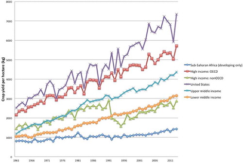
Growth in yields in Africa has been particularly weak over the past three decades, reducing the amount of food produced per capita during this period (Funk & Brown, Citation2009). Agricultural yields remain under 1 metric ton per hectare, about one-fourth of the international average, due to a stagnation in the amount of fertilizer and high-yielding seeds used by smallholder farmers, who make up the majority of all farmers in the region (Nin-Pratt et al., Citation2011). Although aggregate production has improved in Africa during the past 30 years, these gains are far less than other areas that have much more effectively employed technology () (FAO, Citation2016b).
Figure 4. Regional aggregated crop yield per hectare from 1961 to 2013 from the FAO statistics database (FAO, Citation2016b).
The 2006–2008 drought in Zimbabwe provides an example of the impact on food availability of droughts that occur in areas with low per capita agricultural productivity (Simelton et al., Citation2012). Funk and Budde (Citation2009) used satellite-derived vegetation indices to estimate the precipitous decline in production due to the drought in Zimbabwe. This production decline had severe food security consequences because of extremely high inflation and low per capita food production due to the government’s land distribution program earlier in the decade (Scoones et al., Citation2011). This program reduced the number of large commercial farms that used modern agricultural techniques and higher productivity, contributing to much higher per capita cereal production than was available during the drought (Hansen, Mason, Sun, & Tall, Citation2011). The Funk and Budde analysis was conducted for FEWS NET and the World Food Program for their determination of how many people required food assistance during the 2006–2007 and 2007–2008 drought (Funk & Budde, Citation2009).
A critical lack of foreign exchange by both governments and institutions in Zimbabwe due to hyperinflation meant that food imported from international markets would need to be financed by the international community (Coomer & Gstraunthaler, Citation2011). Therefore, determining the total production deficit accurately for aid organizations was important. Changing cultivation patterns due to land reform (Sibanda, Dube, Mubango, & Shoko, Citationin press) meant that assessment of the total amount of food produced needed to estimate cropped area as well in yield due to rainfall deficits (Scoones et al., Citation2011). Funk and Budde used a moderate resolution 30-meter crop mask to remove portions of the landscape not under cultivation together with 16-day MODIS composites to model crop growth throughout the season (Brown, De Beurs, & Vrieling, Citation2010; CSIR, Citation2002; Huete, Justice, & Liu, Citation1994). These two approaches together were able to estimate changes in production and the amount of food aid needed.
Ethiopia is another example of a nation whose population is highly sensitive to interannual variations in food production (Wesenbeeck et al., Citation2009). Agriculture accounts for 46% of the nation’s gross domestic product, 84% of exports, and employs 80% of the labor force (CIA, Citation2012). Not only are many Ethiopians directly dependent on agriculture for their livelihoods but also economic activities involved with marketing, processing, and export of agricultural products support other sectors of the economy (Viste, Korecha, & Sorteberg, Citation2012) ().
Figure 5. Rainfall anomalies from the two most populous regions in Ethiopia using the Climate Hazards Infrared Precipitation with Stations (CHIRPS) rainfall data and Ethiopia annual expenditure data growth per year (%) from the United Nations statistics division.
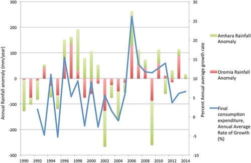
Market imperfections and a widespread lack of access to agricultural resources such as animal labor and fertilizer mean that per capita food production varies enormously across households in the poorer regions of Ethiopia. Holden and Shiferaw (Citation2004) show that the indirect effects of drought on household welfare due to the impact on higher crop prices and lower livestock producer prices are larger than the direct impact of drought on food production. Thus, accurate measurement of the impact of drought on yields or a change in cropped area is important for early response to evolving food security emergencies (Anderson & Choularton, Citation2004; Duffield, Citation1993). Remote sensing is a primary way that food security agencies evaluate the impact of environmental change on food security outcomes.
3 Food access and remote sensing of environmental dynamics
Although the amount of food available in a region affects food security directly, stability of food access is controlled by economic, political, and social factors. Food access is defined by the ability of individuals or households to acquire nutritious and culturally appropriate foods, and involves analysis of the cost of food, physical proximity to food, access to retail outlets or farmable lands, and the social and cultural norms that shape intra-household and intra-community distribution and food preferences (Brown et al., Citation2015). Differences in the ability of households to survive a shock are often quantified using social determinants of vulnerability that can be generalized across space and time even if these determinants are only weakly related to the actual experience of food insecure households (Carr, Abrahams, Poterie, Suarez, & Koelle, Citation2015; Cutter, Boruff, & Shirley, Citation2003). Many assessments of food access focus only on the cost of food, assuming that incomes change only slowly over time for most households (Bellemare, Citation2015). However, changes in agricultural productivity affects not only food availability and potentially its price but also incomes from marketing, transporting, processing, packaging, and other activities supported by the secondary economy (Christiaensen, Weerdt, & Todo, Citation2013). Food access is therefore a common cause of food insecurity, and changes in access can be directly related to changes in local weather shocks if the international price of food is high.
Physical access to markets is a critical part of the ability of rural households to feed themselves. Roads enable access to markets for agricultural output as well as modern inputs, enabling the creation of excess production and its transformation into income for rural households (Jacoby, Citation2000). Access to markets can vary by time of year, with roads being less passable during periods of high rainfall or when time constraints are high due to agricultural labor demands (Becquey & Martin-Prevel, Citation2010). Food prices are likely to be higher during the growing season due to reduced amount of food available and reduced purchasing power in rural areas (Brown, Citation2014). Hillbruner and Egan (Citation2008) document the ways that the weather and seasonal food prices affect household food security and children’s nutritional status in Bangladesh. Changes in the rate of malnutrition in children were also seen in the Gambia (Teokul, Payne, & Dugdale, Citation1986; Tomkins, Dunn, Hayes, & Bradley, Citation1986) and in urban Mozambique (Garrett & Ruel, Citation1999).
The FAO food price index is a common way of evaluating how food prices have changed through time across all countries due to macroeconomic factors. shows the FAO food price index along with the international price of wheat, maize, and petroleum (FAO, Citation2016a). Although prices were high in 2008 and 2011, they have since declined back to 2005 levels due to a recent global slump in commodity prices. Global prices have only a limited connection to local food insecurity, however (Baffes & Gardner, Citation2003). Although the FAO food price index reflects changes in the price of cereals, vegetable oil, dairy, meat, and sugar at capital cities and on the international markets, the poor in developing countries tend to eat millet, sorghum, manioc, cassava, banana, cowpeas, and other locally grown foods that are not included in these indices (Brown et al., Citation2012).
Figure 6. Food and commodity price indices for wheat, maize, crude petroleum, and food from the United Nations statistics service and Food and Agriculture Organization (FAO).
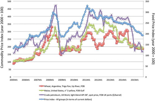
Local food prices in food insecure regions do not immediately follow international export market price trends due to imperfect market integration, prices for local products moving between the export and import parity price bounds, an absence of imported products grown elsewhere, and other barriers to trade (Brown et al., Citation2012; Conforti, Citation2004; Minot, Citation2011). Given these challenges, changes in land use to or away from locally grown agricultural products that are widely consumed by the poor will change access to these products and may result in food insecurity due to changes in access to them. Changes in domestic production along with variations in the international price of a commodity will affect the affordability of a commodity, and as a result the ability of poor households to access it. Thus, by monitoring local food prices along with local agricultural growing conditions, food security analysts can improve their ability to identify food insecurity.
How can we use remote sensing to measure changes in food access? Brown and Kshirsagar (Citation2015) explore this question using 5 years of local food prices from 554 markets across the developing world. The analysis uses an econometric model to estimate the impact on local price changes of changes in international commodity prices and domestic weather, as measured with vegetation index data from the MODIS sensors. Remotely sensed vegetation data were used as a proxy for domestic changes in food production and availability. Although many other factors affect local food prices other than international prices and local growing conditions, including regional markets, distance to ports, informal trade, exchange rates, by focusing on only two factors, the analysis was able to directly explore the impact of local production on local prices.
Results showed that in most of the developing world, a much larger fraction of local food markets are affected by local weather disturbances than by international commodity markets. During the period of analysis, 19% of the 554 commodity–location pairs in the model were affected by local weather disturbances, 9% by international prices, and 4% by both weather and international prices (Brown & Kshirsagar, Citation2015). A consequence of this finding is that if a country has a particularly poor growing season, communities will need to access regional and international food markets to replace the food that it failed to produce itself. Without augmentation of supply, the increased demand in agricultural communities will cause increases in the price of food at the same time that rural incomes are depressed (Brown, Hintermann, & Higgins, Citation2009). Food may be available in these communities, but if the cost is far greater what it normally is, few can afford it (Allen, Citation1998; Becquey et al., Citation2012).
International commodity markets are therefore a critical resource to augment the cereal supplies of nations affected by drought and other climate extremes. Appropriate social safety nets at the national level should be responsive to both international price shocks and to domestic weather that would negatively affect local food production (Alderman & Haque, Citation2006; Grosh et al., Citation2008). Having sufficient observations, local food prices in regions that are likely to experience food insecurity is the foundation of our ability to monitor changes in food access, and therefore food insecurity. The affordability of imported food compared to food that is domestically grown changes dynamically, depending on local agricultural productivity, international commodity prices, and the cost and availability of transporting, processing, wholesaling, and retailing of food as it is accessed by the household. Having information on the cost of different food system elements should be a priority for research in the coming years.
4 Food utilization and land use change
Food utilization is defined as the ability of individuals to make use of the food available and accessible to them. Utilization includes food preferences, preparation, feeding practices, food storage, food safety, and water access. These elements are substantially affected by the care provided to the individual from the household and community of time, attention, and support to meet their physical and social needs (Engle, Menon, & Haddad, Citation1999). Although the literature has noted the importance of care in linking food consumed to nutrition outcomes for more than 30 years, the conceptual frame through which household behaviors result in different nutrition outcomes is relatively new to the food security community (Engle, Lhotska, & Armstrong, Citation1997). Thus, although most food security frameworks recognize the importance of care in evaluating how diet interacts with child and elderly care, health practices, gender, and the availability and functioning of formal health care and sanitation facilities, the integration of these elements into assessing food security outcomes is relatively weak (Britto, Engle, & Super, Citation2013) (). Proximity to institutional resources, such as health care and schools, and the impact of sanitary facilities on nutrition outcomes can be significant, and affect food security through utilization (Myers & Patz, Citation2009).
4.1 Land cover change and nutrition outcomes
Demographic and Health Surveys (DHSs) provide geographically linked, comparable observations of child nutrition across many countries in the developing world. Nutritional outcomes in communities are measured by the nutritional status of its most vulnerable members, children under 5 years of age (Mason, Musgrove, & Habicht, Citation2003). Normal growth patterns of children who are well nourished exhibit similar heights and weights, despite geographic, ethnic, and cultural differences (Habicht, Martorell, Yarbrough, Malina, & Klein, Citation1974; Leroy, Ruel, Habicht, & Frongillo, Citation2014). Any departure from this distribution of optimal growth, therefore, can be attributed to socioeconomic and environmental factors (Brown, Grace, Shively, Johnson, & Carroll, Citation2014). Stunting, or low height for age, and wasting, or low weight for height, are used as indicators of chronic and acute malnutrition in a community (Puffer & Serrano, Citation1973).
Johnson, Jacob, and Brown (Citation2013) used DHS information in Malawi to explore the impact of deforestation on health and nutrition outcomes of over 9000 children under the age of 5. Using satellite remote sensing information, the proportion of the country that had lost forest over the 2000–2010 period was related to the frequency of consumption of vitamin A-rich foods and to the occurrence of diarrhea in children. The locations of communities who responded to the DHS survey were connected to the satellite-derived forest loss map to estimate the proportion of forest cover near each community.
The results showed that higher forest cover is associated with improved health and nutrition outcomes among children in Malawi. Children living in areas with net forest cover loss were 19% less likely to have a diverse diet and 29% less likely to consume vitamin A-rich foods than children living in areas with no deforestation. The research also found that in areas with a net gain in forest cover during the 10-year period were associated with a 34% decrease in the odds of children experiencing diarrhea (Johnson et al., Citation2013). Forests in Malawi provide food, regulating services such as flood production, purification of water, waste absorption, and climate regulation. The study showed that if sanitation services or improved water sources are not provided, an expansion of agricultural area can degrade food security outcomes for the most vulnerable populations, even while per capita food production increases. This study and others like it shows the importance of understanding how land cover has changed through time as natural ecosystems such as forests provide significant ecosystem services that, if not replaced with sanitary services, can greatly affect nutrition outcomes even when food production is increasing. Satellite remote sensing is a crucial input to these assessments. To demonstrate how satellite remote sensing could be used to monitor changes in food security, I present in the next section an analysis of Chad and how multiple factors come together to better understand the causes of a crisis in the country.
5 Connecting drought to food security outcomes in Chad
Chad is a large country in West Africa with significant amount of area in desert and arid pastureland as well as semiarid agricultural areas. In 2016, food security is threatened in Chad because of a late start and poor distribution of the rains in the summer of 2015 ()). Remote sensing data showed a late start in the northern regions in 2015 ()). Coupled with a moisture deficit, the shortened rainy season reduced agricultural yield in some areas of the country. The government estimated the resulting observed regional crop shortfalls, most of which are in the Sahel region, to be the following: Wadi Fira −57%, Kanem −54%, Batha −53%, Bahr El Gazel −27%, Guera −26%, and Sila −24% (FEWSNET, Citation2016).
Figure 7. Food security in Chad, 2015–2016. A. CHIRPS standardized rainfall anomaly, June 1–July 31, 2015. B. MODIS NDVI percent anomaly for July 16–25, 2015. C. Start of season anomaly for 2015 growing season, number of 10-day periods (dekads) later than normal. D. Integrated Acute Food Security Phase Classification (IPC) for Chad for the period of February to May 2016 from the Famine Early Warning Systems Network (IPC, Citation2012).
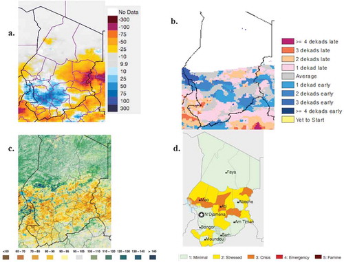
Remote sensing is also used to evaluate pasture and rangeland health. Poor vegetation growth in the peak of the summer growing season in 2015 ()) resulted in degraded and below normal pasture conditions at the end of the dry season in 2016. By March 2016, markets have large numbers of livestock with degraded physical condition due to their need to travel long distances to find healthy grass and water. As a result, pastoral incomes have decreased causing consumption deficits in these households (FEWSNET, Citation2016).
Farming households who had reduced yields in 2015 reported that their household cereal stocks were depleted in March instead of in June 2016, greatly increasing the demand for grain on the markets several months early. Although grain prices are stable due to substantial food imports, large numbers of households have reduced their consumption due to lack of income to purchase food to replace the food they failed to grow in 2015 ()) (Brown et al., Citation2009). These areas are now stressed (Integrated Acute Food Security Phase Classification (IPC) phase 2), which means that households in the region have minimally adequate food consumption but are unable to afford some essential nonfood expenditures without engaging in irreversible coping strategies. Agricultural areas in the Sahelian part of Chad that experienced reduced food production in 2015 are now thought to be in ‘crisis’ or phase 3 of the Acute Food Insecurity Phase system in March of 2016, where households have food consumption gaps with high or above average acute malnutrition or where households are marginally able to meet minimum food needs only with accelerated depletion of livelihood assets that will lead to additional food consumption gaps (IPC, Citation2012).
FEWS NET produces food security analyses by having field offices that employ local residents, by networking with nongovernmental, governmental, and private organizations in the country, and by using human intelligence gathered from experts in the region. This does not mean, however, that information gathered in Chad and other FEWS NET countries is organized in a way that is accessible by researchers from the outside. Changes in the goals of food security assessments every few years means that the information presented in food security reports generated by FEWS NET are not comparable across years, and since the data used to generate the reports are not captured quantitatively, little progress can be made in understanding the sources of vulnerability across regions. More data that are specific to households are necessary to improve these assessments and food security research overall, including local prices of appropriate commodities, wage labor availability, livestock prices, human health and nutrition information, and among other factors.
6 Conclusions
In this paper, I examined ways in which remote sensing data can be used to analyze food availability, access, and nutrition outcomes relevant to food security. By examining the multiple ways food security may be affected by environmental change, research questions can be developed that extend the use of satellite data beyond simply monitoring yield. The food system extends beyond food production to include the processing, packaging, transporting, retailing, consuming, and disposing of food. The community can better understand how environmental change may affect food security in the future if we develop methodological approaches that can identify connections between remote sensing-based observed changes in the environment.
Satellite remote sensing cannot provide information about social and economic factors that are at the heart of food security such as trade, economic growth, changes in equality, or distribution of resources within a household. shows a number of parameters that cannot be observed with remote sensing information that are critical to understanding food security outcomes. The ability of families to provide proper nutrition for their children in the first years of life is profoundly affected by the resources available to them. The ability to produce food, or to purchase food in the market, depends on productive resources and the vitality of the economy. Many countries rely upon local agricultural production to employ its residents and to produce the majority of food consumed. Satellite remote sensing is central to understanding resource availability and thus is likely to remain an important tool for this community in coming years.
Remote sensing data can inform a number of food security elements that are central to ensuring the stability of food availability, access, and utilization, which result in good food security outcomes. Making the best use of the data requires spatially specific knowledge of the social, economic, and biophysical context in which environmental change occurs. Gathering and distributing these datasets should be a priority in coming decades through interdisciplinary research, exploiting new information and communication technologies and by prioritizing research that seeks to improve our knowledge of the causes of food insecurity.
Disclosure statement
No potential conflict of interest was reported by the author.
Additional information
Notes on contributors
Molly E Brown
Molly E Brown is a Research Associate Professor at the University of Maryland. She has fifteen years of experience in interdisciplinary research using satellite remote sensing data and models with socio-economic and demographic information to better understand food security drivers.
References
- Alderman, H., & Haque, T. (2006). Countercyclical safety nets for the poor and vulnerable. Food Policy, 31(4), 372–383. doi:10.1016/j.foodpol.2006.02.003
- Allen, T. (1998). From ‘informal sectors’ to ‘real economies’: Changing conceptions of Africa’s hidden livelihoods. Contemporary Politics, 4(4), 357–373. doi:10.1080/13569779808449977
- Anderson, S., & Choularton, R. (2004). Retrospective analysis 2002/3 Crisis in Ethiopia: Early warning and response. Washington, DC: US Agency for International Development’s Famine Early Warning System Network.
- Antwi-Agyei, P., Fraser, E. D. G., Dougill, A. J., Stringer, L. C., & Simelton, E. (2012). Mapping the vulnerability of crop production to drought in Ghana using rainfall, yield and socioeconomic data. Applied Geography, 32(2), 324–334. doi:10.1016/j.apgeog.2011.06.010
- Baffes, J., & Gardner, B. (2003). The transmission of world commodity prices to domestic markets under policy reforms in developing countries. The Journal of Policy Reform, 6(3), 159–180. doi:10.1080/0951274032000175770
- Baumgartner, P., Braun, J. V., Abebaw, D., & Müller, M. (2015). Impacts of large-scale land investments on income, prices, and employment: Empirical analyses in Ethiopia. World Development, 72, 175–190. doi:10.1016/j.worlddev.2015.02.017
- Beaugrand, G., & Reid, P. C. (2003). Long-term changes in phytoplankton, zooplankton and salmon related to climate. Global Change Biology, 9(6), 801–817. doi:10.1046/j.1365-2486.2003.00632.x
- Becker-Reshef, I., Justice, C., Sullivan, M., Vermote, E., Tucker, C. J., Anyamba, A., … Doorn, B. (2010). Monitoring global croplands with coarse resolution earth observations: The global agriculture monitoring (GLAM) project. Remote Sensing Journal, 2, 1589–1609. doi:10.3390/rs2061589
- Becquey, E., Delpeuch, F., Konaté, A. M., Delsol, H., Lange, M., Zoungrana, M., & Martin-Prevel, Y. (2012). Seasonality of the dietary dimension of household food security in urban Burkina Faso. British Journal of Nutrition, 107(12), 1860–1870. doi:10.1017/S0007114511005071
- Becquey, E., & Martin-Prevel, Y. (2010). Micronutrient adequacy of women’s diet in urban Burkina Faso is low. Journal of Nutrition, 140, 2079S–2085S. doi:10.3945/jn.110.123356
- Bellemare, M. F. (2015). Rising food prices, food price volatility, and social unrest. American Journal of Agricultural Economics, 97(1), 1–21. doi:10.1093/ajae/aau038
- Benini, A. A. (1992). Armed conflict, access to markets, and food crisis warning: A note from Mali. Disasters, 16(3), 240–248. doi:10.1111/disa.1992.16.issue-3
- Bhutta, Z. A., Ahmed, T., Black, R. E., Cousens, S., Dewey, K., Giugliani, E., … Shekar, M. (2008). What works? Interventions for maternal and child undernutrition and survival. The Lancet, 371(9610), 417–440. doi:10.1016/S0140-6736(07)61693-6
- Bolton, D. K., & Friedl, M. A. (2013). Forecasting crop yield using remotely sensed vegetation indices and crop phenology metrics. Agricultural and Forest Meteorology, 173, 74–84. doi:10.1016/j.agrformet.2013.01.007
- Brashares, J. S., Golden, C. D., Weinbaum, K. Z., Barrett, C. B., & Okello, G. V. (2001). Economic and geographic drivers of wildlife consumption in rural Africa. Proceedings of the National Academy of Sciences, 108(34), 13931–13936. doi:10.1073/pnas.1011526108
- Brink, A. B., & Eva, H. D. (2009). Monitoring 25 years of land cover change dynamics in Africa. A Sample Based Remote Sensing Approach Applied Geography, 29, 501–512. doi:10.1016/j.apgeog.2008.10.004
- Brinkman, H., & Hendrix, C. S. (2011). Food insecurity and violent conflict: Causes, consequences and addressing the challenges (Occasional Paper 24). Rome: United Nations World Food Programme.
- Britto, P. R., Engle, P. L., & Super, C. M. (2013). Handbook of early childhood development research and its impact on global policy. Oxford, UK: Oxford University Press.
- Brown, M. E. (2014). Food security, food prices and climate variability. London: Earthscan Routledge Press.
- Brown, M. E., Antle, J. M., Backlund, P., Carr, E. G., Easterling, W. E., Walsh, M. K., … Tebaldi, C. (2015). Climate change, global food security, and the U.S. food system. Washington, DC: United States Department of Agriculture (USDA).
- Brown, M. E., De Beurs, K., & Vrieling, A. (2010). The response of African land surface phenology to large scale climate oscillations. Remote Sensing of Environment, 114(10), 2286–2296. doi:10.1016/j.rse.2010.05.005
- Brown, M. E., Funk, C., Galu, G., & Choularton, R. (2007). Earlier famine warning possible using remote sensing and models. Eos, Transactions American Geophysical Union, 88(39), 381–382. doi:10.1029/2007EO390001
- Brown, M. E., Grace, K., Shively, G., Johnson, K., & Carroll, M. (2014). Using satellite remote sensing and household survey data to assess human health and nutrition response to environmental change. Population and Environment, 36(1), 48–72. doi:10.1007/s11111-013-0201-0
- Brown, M. E., Hintermann, B., & Higgins, N. (2009). Markets, climate change and food security in West Africa. Environmental Science and Technology, 43(21), 8016–8020. doi:10.1021/es901162d
- Brown, M. E., & Kshirsagar, V. (2015). Weather and international price shocks on food prices in the developing world. Global Environmental Change, 35, 31–40. doi:10.1016/j.gloenvcha.2015.08.003
- Brown, M. E., & Mata, T. M. (2016). How is climate change affecting the global food system? In R. O. Rios & R. Pritchard (Eds.), Handbook of food and nutrition security. New York, NY: Routledge Press.
- Brown, M. E., Tondel, F., Essam, T., Thorne, J. A., Mann, B. F., Leonard, K., … Eilerts, G. (2012). Country and regional staple food price indices for improved identification of food insecurity. Global Environmental Change, 22(3), 784–794. doi:10.1016/j.gloenvcha.2012.03.005
- Carr, E. R., Abrahams, D., Poterie, A. T. D. L., Suarez, P., & Koelle, B. (2015). Vulnerability assessments, identity and spatial scale challenges in disaster-risk reduction. Jàmbá: Journal of Disaster Risk Studies, 7(1), 1–17. doi:10.4102/jamba.v7i1.201
- Christiaensen, L., Weerdt, J. D., & Todo, Y. (2013). Urbanization and poverty reduction: The role of rural diversification and secondary towns. Agricultural Economics, 44(4–5), 435–447. doi:10.1111/agec.12028
- CIA. (2012). Central Intelligence Agency World Factbook from United States Government. Retrieved from https://www.cia.gov/library/publications/the-world-factbook/
- Conforti, P. (2004). Price transmission in selected agricultural markets (FAO Working Paper No. 7). Rome: United Nations Food and Agriculture Organization.
- Coomer, J., & Gstraunthaler, T. (2011). The hyperinflation in Zimbabwe. The Quarterly Journal of Austrian Economics, 14(3), 311–346.
- CSIR. (2002). The SADC Regional Land Cover Database Project. Gaborone: Council for Scientific and Industrial Research.
- Cuny, F. C., & Hill, R. B. (1999). Famine, conflict and response: A basic guide. West Hartford, CT: Kumarian Press.
- Cutter, S. L., Boruff, B. J., & Shirley, W. L. (2003). Social vulnerability to environmental hazards. Social Science Quarterly, 84(2), 242–261. doi:10.1111/ssqu.2003.84.issue-2
- Dangour, A. D., Green, R., Häsler, B. H., Rushton, J., Shankar, B., & Waage, J. (2012). Symposium 1: Food chain and health linking agriculture and health in low- and middle-income countries: An interdisciplinary research agenda. Proceedings of the Nutrition Society, 71, 222–228. doi:10.1017/S0029665112000213
- Davies, D. K., Murphy, K. J., Michael, K., Becker-Reshef, I., Justice, C. O., Boller, R., … Morin, P. J. (2015). The use of NASA LANCE imagery and data for near real-time applications. In C. D. Lippitt, D. A. Stow, & L. L. Coulter (Eds.), Time-sensitive remote sensing (pp. 165–182). New York, NY: Spring.
- DeFries, R. S., Balstad, R., Colwell, R., Evans, T. P., Lam, -N. S.-N., Michaelsen, J., … Wilson, M. L. (2007). Contributions of land remote sensing for decisions about food security and human health: NRC workshop report. Washington, DC: National Academies Press.
- Deryng, D., Sacks, W. J., Barford, C. C., & Ramankutty, N. (2011). Simulating the effects of climate and agricultural management practices on global crop yield. Global Biogeochemical Cycles, 25, GB2006. doi:10.1029/2009GB003765
- Devereux, S. (1988). Entitlements, availability, and famine. Food Policy, 13, 270–282. doi:10.1016/0306-9192(88)90049-8
- Duffield, M. (1993). NGOs, disaster relief, and asset transfer in the horn: Political survival in a permanent emergency. Development and Change, 24, 131–158. doi:10.1111/dech.1993.24.issue-1
- Ehret, G., Kiemle, C., Wirth, M., Amediek, A., Fix, A., & Houweling., S. (2008). Space-borne remote sensing of CO2, CH4, and N2O by integrated path differential absorption lidar: A sensitivity analysis. Applied Physics B, 90(3–4), 593–608. doi:10.1007/s00340-007-2892-3
- Elvidge, C. D., Erwin, E. H., Baugh, K. E., Ziskin, D., Tuttle, B. T., Ghosh, T., & Sutton, P. C. (2009). Overview of DMSP nightime lights and future possibilities. Urban Remote Sensing Event, 2009 Joint, Shanghai.
- Enenkel, M., See, L., Bonifacio, R., Boken, V., Chaney, N., Vinck, P., … Anderson, M. (2015). Drought and food security – Improving decision-support via new technologies and innovative collaboration. Global Food Security, 4, 51–55. doi:10.1016/j.gfs.2014.08.005
- Engle, P. L., Lhotska, L., & Armstrong, H. (1997). The care initiative: Guidelines for analysis, assessment, and action to improve nutrition. New York, NY: UNICEF.
- Engle, P. L., Menon, P., & Haddad, L. (1999). Care and nutrition: Concepts and measurements. World Development, 27(8), 1309–1337. doi:10.1016/S0305-750X(99)00059-5
- FAO. (1996). World food summit: Rome declaration on world food security. Rome: United Nations Food and Agriculture Organization.
- FAO. (2012a). Food, agriculture and cities: The challenges of food and nutrition security, agriculture and ecosystem management in an urbanizing world. Rome: United Nations Food and Agriculture Organization.
- FAO. (2012b). The state of world fisheries and aquaculture. Rome: United Nations Food and Agriculture Organization.
- FAO. (2015). The state of food insecurity in the world 2015. Rome: United Nations Food and Agriculture Organization. Retrieved from http://www.fao.org/publications
- FAO. (2016a). FAO food price index. Rome: United Nations Food and Agriculture Organization.
- FAO. (2016b). FAO statistical database. Retrieved from http://apps.fao.org/cgi-bin/nph-db.pl?subset=agriculture
- FEWSNET. (2016). The food situation is deteriorating in the Sahelian zone due to early lean seasons. Washington, DC: US Agency for International Development’s Famine Early Warning System Network. Retrieved from http://www.fews.net/west-africa/chad
- Field, C. B., Barros, V., Stocker, T. F., Qin, D., Dokken, D. J., Ebi, K. L., … Midgley, P. M. (2012). Managing the Risks of Extreme Events and Disasters to Advance Climate Change Adaptation. A Special Report of Working Groups I and II of the Intergovernmental Panel on Climate Change. Cambridge, UK: Cambridge University Press.
- Flegal, K. M., Kit, B. K., Orpana, H., & Graubard, B. I. (2013). Association of all-cause mortality with overweight and obesity using standard body mass index categories. Journal of the American Medical Association, 309(1), 71–82. doi:10.1001/jama.2012.113905
- Flora, C. B. (2010). Food security in the context of energy and resource depletion: Sustainable agriculture in developing countries. Renewable Agriculture and Food Systems, 25(02), 118–128. doi:10.1017/S1742170510000177
- Foley, J. A., DeFries, R., Asner, G. P., Barford, C., Bonan, G., Carpenter, S. R., … Snyder, P. K. (2005). Global consequences of land use. Science, 309, 570–574. doi:10.1126/science.1111772
- Fowler, H. J., & Kilsby, C. G. (2003). Implications of changes in seasonal and annual extreme rainfall. Geophysical Research Letters, 30(13). doi:10.1029/2003GL017327
- Fritz, S., See, L., McCallum, I., You, L., Bun, A., Moltchanova, E., … Obersteiner, M. (2015). Mapping global cropland and field size. Global Change Biology, 21(5), 1980–1992. doi:10.1111/gcb.12838
- Funk, C., & Brown, M. E. (2009). Declining global per capita agricultural production and warming oceans threaten food security. Food Security Journal, 1(3), 271–289. doi:10.1007/s12571-009-0026-y
- Funk, C., Peterson, P., Landsfeld, M., Pedreros, D., Verdin, J., Shukla, S., … Michaelsen, J. (2015). The climate hazards infrared precipitation with stations—A new environmental record for monitoring extremes. Scientific Data, 2, 150066. doi:10.1038/sdata.2015.66
- Funk, C., Verdin, A., Michaelsen, J., Peterson, P., Pedreros, D., & Husak, G. (2015). A global satellite assisted precipitation climatology. Earth System Science Data Discussions, 8, 401–425. doi:10.5194/essdd-8-401-2015
- Funk, C. C., & Budde, M. E. (2009). Phenologically-tuned MODIS NDVI-based production anomaly estimates for Zimbabwe. Remote Sensing of Environment, 113(1), 115–125. doi:10.1016/j.rse.2008.08.015
- Galvin, K. A., Thornton, P. K., Boone, R. B., & Sunderland, J. (2004). Climate variability and impacts on east African livestock herders: The Maasai of Ngorongoro Conservation Area, Tanzania. African Journal of Range and Forage Science, 21(3), 183–189. doi:10.2989/10220110409485850
- Garrett, J. L., & Ruel, M. (1999). Are determinants of rural and urban food security and nutritional status different? Some insights from Mozambique. World Development, 27, 1955–1975. doi:10.1016/S0305-750X(99)00091-1
- Golden, C. D., Fernald, L. C. H., Brashares, J. S., Rasolofoniaina, B. J. R., & Kremen, C. (2011). Benefits of wildlife consumption to child nutrition in a biodiversity hotspot. Proceedings of the National Academy of Sciences, 108(49), 19653–19656. doi:10.1073/pnas.1112586108
- Grace, K., Brown, M. E., & McNally, A. (2014). Examining the link between food prices and food insecurity: A multi-level analysis of maize price and birthweight in Kenya. Food Policy, 46, 56–65. doi:10.1016/j.foodpol.2014.01.010
- Grace, K., Husak, G., Harrison, L., Pedreros, D., & Michaelsen, J. (2012). Using high resolution satellite imagery to estimate cropped area in Guatemala and Haiti. Applied Geography, 32, 433–440. doi:10.1016/j.apgeog.2011.05.014
- Grosh, M., Ninno, C. D., Tesliuc, E., & Ouerghi, A. (2008). For protection and promotion: The design and implementation of effective safety nets. Washington, DC: The World Bank.
- Habicht, J. P., Martorell, R., Yarbrough, C., Malina, R. M., & Klein, R. E. (1974). Height and weight standards for preschool children: How relevant are ethnic differences in growth potential. The Lancet, 303, 611–615. doi:10.1016/S0140-6736(74)92663-4
- Hansen, J. W., Mason, S. J., Sun, L., & Tall, A. (2011). Review of seasonal climate forecasting for agriculture in sub-Saharan Africa. Experimental Agriculture, 47(2), 205–240. doi:10.1017/S0014479710000876
- Hatfield, J. L., & Prueger, J. H. (2015). Temperature extremes: Effect on plant growth and development. Weather and Climate Extremes, 10, 4–10. doi:10.1016/j.wace.2015.08.001
- Hillbruner, C., & Egan, R. (2008). Seasonality, household food security, and nutritional status in Dinajpur, Bangladesh. Food and Nutrition Bulletin, 29(3), 221–231. doi:10.1177/156482650802900308
- Hoefsloot, P., Ines, A., Dam, J., Duveiller, G., Kayitakire, F., & Hansen, J. (2012). Combining crop models and remote sensing for yield prediction: Concepts, applications and challenges for heterogeneous smallholder environments. Ispra: CGIAR Research Program on Climate Change, Agriculture and Food Security (CCAFS) and the Joint Research Centre of the European Commission.
- Holden, S., & Shiferaw, B. (2004). Land degradation, drought and food security in a less-favoured area in the Ethiopian highlands: A bio-economic model with market imperfections. Agricultural Economics, 30(1), 31–49. doi: 10.1111/j.1574-0862.2004.tb00174.x
- Huete, A., Justice, C., & Liu, H. (1994). Development of vegetation and soil indices for MODIS-EOS. Remote Sensing of Environment, 49, 224–234. doi:10.1016/0034-4257(94)90018-3
- Husak, G. J., Marshall, M. T., Michaelsen, J., Pedreros, D., Funk, C., & Galu, G. (2008). Crop area estimation using high and medium resolution satellite imagery in areas with complex topography. Journal of Geophysical Research-Atmospheres, 113, D14112. doi:10.1029/2007JD009175
- IAASTD. (2008). International assessment of agricultural knowledge, science and technology for development. London: Island Press.
- IPC. (2012). Integrated food security phase classification technical manual version 2.0: Evidence and standards for better food security decisions. Rome: Food and Agriculture Organization (FAO).
- Jaacks, L. M., Slining, M. M., & Popkin, B. M. (2015). Recent underweight and overweight trends by rural–urban residence among women in low- and middle-income countries. Journal of Nutrition, 145(2), 352–357. doi:10.3945/jn.114.203562
- Jacoby, H. G. (2000). Access to markets and the benefits of rural roads. The Economic Journal, 110(465), 713–737. doi:10.1111/1468-0297.00562
- Jarosz, L. (2014). Comparing food security and food sovereignty discourses. Dialogues in Human Geography, 4(2), 168–181. doi:10.1177/2043820614537161
- Jensen, J. R. (2006). Remote sensing of the environment: An earth resource perspective (2nd ed.). Upper Saddle River, NJ: Prentice Hall.
- Johnson, K. B., Jacob, A., & Brown, M. E. (2013). Forest cover associated with improved child health and nutrition: Evidence from the Malawi demographic and health survey and satellite data. Global Health: Science and Practice, 1(2), 237–248. doi:10.9745/GHSP-D-13-00055
- Kenyon, W., Hill, G., & Shannon, P. (2008). Scoping the role of agriculture in sustainable flood management. Land Use Policy, 25(3), 351–360. doi:10.1016/j.landusepol.2007.09.003
- Kochhar, R. (2015). A global middle class is more promise than reality: From 2001 to 2011, nearly 700 million step out of poverty, but most only barely. Washington, DC: Pew Research Center.
- Konandreas, P. (2012). Trade policy responses to food price volatility in poor net food-importing countries. ICTSD Programme on Agricultural Trade and Sustainable Development, Issue Paper No. 42.
- Krause, M., Lotze-Campen, H., Popp, A., & Dietrich, J. P. (2013). Conservation of undisturbed natural forests and its economic impacts on agriculture. Land Use Policy, 30, 344–354. doi:10.1016/j.landusepol.2012.03.020
- Leroy, J. L., Ruel, M., Habicht, J.-P., & Frongillo, E. A. (2014). Linear growth deficit continues to accumulate beyond the first 1000 days in low- and middle-income countries: Global evidence from 51 national surveys 1,2. Journal of Nutrition, 144(9), 1460–1466. doi:10.3945/jn.114.191981
- Lo, C. P. (2001). Modeling the population of china using DMSP operational linescan system nighttime data. Photogrammetric Engineering & Remote Sensing, 67(9), 1037–1047.
- MacDonald, G. K., Brauman, K. A., Sun, S., Carlson, K. M., Cassidy, E. S., Gerber, J. S., & West, P. C. (2015). Rethinking agricultural trade relationships in an era of globalization. BioScience, 65(3), 275–289. doi:10.1093/biosci/biu225
- Magan, N., Hope, R., Cairns, V., & Aldred, D. (2003). Post-harvest fungal ecology: Impact of fungal growth and mycotoxin accumulation in stored grain. European Journal of Plant Pathology, 109(7), 723–730. doi:10.1023/A:1026082425177
- Mason, J., Musgrove, P., & Habicht, J.-P. (2003). At least one-third of poor countries’ disease burden is due to malnutrition. Bethesda, MD: Disease Control Priorities Project (DCPP) Work.
- McCusker, B., & Carr, E. R. (2006). The co-production of livelihoods and land use change: Case studies from South Africa and Ghana. Geoforum, 37, 790–804. doi:10.1016/j.geoforum.2005.09.007
- Minot, N. (2011). Transmission of world food price changes to markets in Sub-Saharan Africa (IFPRI Discussion Paper 01239). Washington, DC: International Food Policy Research Institute (IFPRI).
- Munroe, D. K., McSweeney, K., Olson, J. L., & Mansfield, B. (2014). Using economic geography to reinvigorate land-change science. Geoforum, 52, 12–21. doi:10.1016/j.geoforum.2013.12.005
- Mwila, A. M., Banda, D., & Kabwe, P. (2004). Review of the Zambia national food balance sheet. Washington, DC: US Agency for International Development’s Famine Early Warning System Network.
- Myers, S., & Patz, J. (2009). Emerging threats to human health from global environmental change. Annual Review of Environment and Resources, 34, 223–252. doi:10.1146/annurev.environ.033108.102650
- Myers, S. S., Zanobetti, A., Kloog, I., Huybers, P., Leakey, A. D. B., Bloom, A. J., … Usui, Y. (2014). Increasing CO2 threatens human nutrition. Nature, 510, 139–142. doi:10.1038/nature13179
- Nin-Pratt, A., Johnson, M., Magalhaes, E., You, L., Diao, X., & Chamberlin, J. (2011). Yield gaps and potential agricultural growth in West and Central Africa (Research Monograph 170). Washington, DC: International Food Policy Research Institute (IFPRI).
- Panthou, G., Vischel, T., Lebel, T., Blanchet, J., Quantin, G., & Ali, A. (2012). Extreme rainfall in West Africa: A regional modeling. Water Resources Research, 48, W08501. doi:10.1029/2012WR012052
- Popkin, B. M. (2004). The nutrition transition: An overview of world patterns of change. Nutrition Reviews, 62(2), S140–S143. doi:10.1111/j.1753-4887.2004.tb00084.x
- Puffer, R. R., & Serrano, C. V. (1973). Patterns of mortality in childhood. Washington, DC: World Health Organization (WHO).
- Quisumbing, A. R., & Maluccio, J. A. (2000). Intrahousehold allocation and gender relations: New empirical evidence from four developing countries. Washington, DC: International Food and Policy Research Institute (IFPRI).
- Ramankutty, N., Evan, A. T., Monfreda, C., & Foley, J. A. (2008). Farming the planet: 1. Geographic distribution of global agricultural lands in the year 2000. Global Biogeochemical Cycles, 22, GB1003. doi:10.1029/2007GB002952
- Rayner, N. A., Parker, D. E., Horton, E. B., Folland, C. K., Alexander, L. V., Rowell, D. P., … Kaplan, A. (2003). Global analyses of sea surface temperature, sea ice, and night marine air temperature since the late nineteenth century. Journal of Geophysical Research-Atmospheres, 108(D14). doi:10.1029/2002JD002670
- Reardon, T. (1997). Using evidence of household income diversification to inform study of the rural nonfarm labor market in Africa. World Development, 25(5), 735–747. doi:10.1016/S0305-750X(96)00137-4
- Reardon, T., Delgado, C., & Matlon, P. (1992). Determinants and effects of income diversification amongst farm households in Burkina Faso. The Journal of Development Studies, 28(2), 264–296. doi:10.1080/00220389208422232
- Remans, R., Wood, S. A., Saha, N., Anderman, T. L., & DeFries, R. S. (2015). Measuring nutritional diversity of national food supplies. Global Food Security, 3(3–4), 174–182. doi:10.1016/j.gfs.2014.07.001
- Rembold, F., Atzberger, C., Rojas, O., & Savin, I. (2013). Using low resolution satellite imagery for yield prediction and yield anomaly detection. Remote Sensing Journal, 5(4), 1704–1733. doi:10.3390/rs5041704
- Rosegrant, M. W., Msangi, S., Sulser, T., & Valmonte-Santos, R. (2006). Biofuels and the global food balance. Washington, DC: 2020 Vision for Food, Agriculture and the Environment.
- Ryan, S. J., Cross, P. C., Winnie, J., Hay, C., Bowers, J., & Getz, W. M. (2012). The utility of normalized difference vegetation index for predicting African buffalo forage quality. The Journal of Wildlife Management, 76(7), 1499–1508. doi:10.1002/jwmg.407
- Scoones, I., Marongwe, N., Mavedzenge, B., Murimbarimba, F., Mahenehene, J., & Sukume, C. (2011). Zimbabwe’s land reform: Challenging the myths. Journal of Peasant Studies, 38(5), 967–993. doi:10.1080/03066150.2011.622042
- Seaman, J. (2000). Making exchange entitlements operational: The food economy approach to famine prediction and the RiskMap computer program. Disasters, 24(2), 133–152. doi:10.1111/disa.2000.24.issue-2
- Sen, A. (1990). Food, economics and entitlements. In J. Dreze & A. Sen (Eds.), The political economy of hunger (Vol. 1, pp. 10–45). New York, NY: Clarendon Press.
- Shepherd, A., Mitchell, T., Lewis, K., Lenhardt, A., Jones, L., Scott, L., & Muir-Wood, R. (2013). The geography of poverty, disasters and climate extremes in 2030. London: Overseas Development Institute (ODI).
- Sibanda, M., Dube, T., Mubango, T., & Shoko, C. (in press). The utility of earth observation technologies in understanding impacts of land reform in the eastern region of Zimbabwe. Journal of Land Use Science, 1–19. doi:10.1080/1747423X.2015.1130756
- Simelton, E., Fraser, E. D. G., Termansen, M., Benton, T. G., Gosling, S. N., South, A., … Forster, P. M. (2012). The socioeconomics of food crop production and climate change vulnerability: A global scale quantitative analysis of how grain crops are sensitive to drought. Food Security Journal, 4(2), 163–179. doi:10.1007/s12571-012-0173-4
- Smith, J., Tappan, G. G., Husak, G., & Crane, M. (2006). Zimbabwe 2005 remotely sensed cropped area assessment. Santa Barbara, CA: University of California.
- Swinburn, B. A., Sacks, G., Hall, K. D., McPherson, K., Finegood, D. T., Moodie, M. L., & Gortmaker, S. L. (2011). The global obesity pandemic: Shaped by global drivers and local environments. The Lancet, 378(9793), 804–814. doi:10.1016/S0140-6736(11)60813-1
- Teklu, T. (1991). Household responses to declining food entitlement: The experience in Western Sudan. Quarterly Journal of International Agriculture, 31(3), 247–261.
- Teokul, W., Payne, P., & Dugdale, A. (1986). Seasonal variations in nutritional status in rural areas of developing countries: A review of the literature. Food Nutrition Bulletin, 8, 7–10.
- Tirado, M. C., Clarke, R., Jaykus, L. A., McQuatters-Gollop, A., & Frank, J. M. (2010). Climate change and food safety: A review. Food Research International, 43, 1745–1765. doi:10.1016/j.foodres.2010.07.003
- Tittonell, P., & Giller, K. E. (2013). When yield gaps are poverty traps: The paradigm of ecological intensification in African smallholder agriculture. Field Crops Research, 143, 76–90. doi:10.1016/j.fcr.2012.10.007
- Tomkins, A., Dunn, D., Hayes, R., & Bradley, A. (1986). Seasonal variations in the nutritional status of urban Gambian children. British Journal of Nutrition, 56, 533–543. doi:10.1079/BJN19860134
- Tschirley, D., & Weber, M. T. (1994). Food security strategies under extremely adverse conditions: The determinants of household income and consumption in rural Mozambique. World Development, 22(2), 159–173. doi:10.1016/0305-750X(94)90067-1
- Tucker, C. J., Pinzon, J. E., Brown, M. E., Slayback, D., Pak, E. W., Mahoney, R., … El Saleous, N. (2005). An extended AVHRR 8-km NDVI data set compatible with MODIS and SPOT vegetation NDVI data. International Journal of Remote Sensing, 26(20), 4485–4498. doi:10.1080/01431160500168686
- Udry, C. (1996). Gender, agricultural production, and the theory of the household. Journal of Political Economy, 104(5), 1010–1046. doi:10.1086/262050
- United Nations. (2015). World urbanization prospects: The 2015 revision. New York, NY: United Nations Department of Economic and Social Affairs, Population Division.
- Verdin, J., Funk, C., Senay, G., & Choularton, R. (2005). Climate science and famine early warning. Philosophical Transactions of the Royal Society B: Biological Sciences, 360(1463), 2155–2168. doi:10.1098/rstb.2005.1754
- Vermeulen, S. J., Aggarwal, P. K., Ainslie, A., Angelone, C., Campbell, B. M., Challinor, A. J., … Wollenberg, E. (2012). Options for support to agriculture and food security under climate change. Environmental Science & Policy, 15, 136–144. doi:10.1016/j.envsci.2011.09.003
- Vermeulen, S. J., Campbell, B. M., & Ingram, J. S. I. (2012). Climate change and food systems. Annual Review of Environment and Resources, 37, 195–222. doi:10.1146/annurev-environ-020411-130608
- VerPloeg, M., Breneman, V., Farrigan, T., Hamrick, K., Hopkins, D., Kaufman, P., … Tuckermanty, E. (2012). Access to affordable and nutritious food: Measuring and understanding food deserts and their consequences. Washington, DC: Economic Research Service, US Department of Agriculture.
- Viste, E., Korecha, D., & Sorteberg, A. (2012). Recent drought and precipitation tendencies in Ethiopia. Theoretical and Applied Climatology, 112(3–4), 535–551. doi:10.1007/s00704-012-0746-3
- Wan, Z. (2008). New refinements and validation of the MODIS land-surface temperature/emissivity products. Remote Sensing of Environment, 112(1), 59–74. doi:10.1016/j.rse.2006.06.026
- Weisz, A., Manary, M., Stephenson, K., Agapova, S., Manary, F., Thakwalakwa, C., … Manary, M. J. (2012). Abnormal gut integrity is associated with reduced linear growth in rural Malawian children. Journal of Pediatric Gastroenterology and Nutrition, 55, 747–750. doi:10.1097/MPG.0b013e3182650a4d
- Weng, Q. (2012). Remote sensing of impervious surfaces in the urban areas: Requirements, methods, and trends. Remote Sensing of Environment, 117, 34–49. doi:10.1016/j.rse.2011.02.030
- Wesenbeeck, C. F. A. V., Keyzer, M. A., & Nube, M. (2009). Estimation of undernutrition and mean calorie intake in Africa: Methodology, findings and implications. International Journal of Health Geographics, 8(37), 1–18. doi:10.1186/1476-072X-8-37