
ABSTRACT
Cultivated and settlement areas were studied in a small area (14 km2) in South Wollo, Ethiopia, by aerial photos, satellite images, field observations and interviews. Areas for cultivation/rural settlement decreased a few per cent between 1958 and 2013. Cultivated land per household slowly decreased in 1958–2003 but in 2003–2013 the annual decrease was 3–4 times higher. New farm buildings are often built on cultivated land, and abandoned buildings areas return to cultivation. Rainwater harvesting ponds have increased the areas with perennial crops that are important as a source of income. Tin roofed buildings are signs of improved livelihood. Very small farm size and rain-dependent agriculture combined with climate variability make food security vulnerable. Land-use inventories including remote sensing and local knowledge would be a valuable approach to assess livelihood needs. Further, it should involve decision makers at different levels, but local agricultural extension officers may play a central role.
1. Introduction
The population in Ethiopia was 21 million in 1958, while in 2013 the population had increased to almost 95 million (World Bank, Citation2016a). The annual population growth in 2013 was estimated to be 2.6% but exceeded 3% in 1983–1997 (World Bank, Citation2016b). There has been a considerable migration into towns and cities but still the rural population increase was as high as 2.0% annually in 2010 (World Bank, Citation2016c). The growing rural population has increased the demand for new cropland, but also the pressure on existing cropland. Several studies of land use/land cover (LULC) show considerable changes of the cultivated area in southern Ethiopia and in some areas in the northwest since the 1950s ( including references). Forest areas, shrub land and marginal land areas have turned into cultivated land. However, in South Wollo in the eastern part of the Ethiopian highlands the increase in cropland has been limited in all but one study (Shiferaw, Citation2011). A low rate of increase in cropland suggests that all suitable cropland was already in use at the starting years of these studies, e.g. Amsalu, Stroosnijder, and De Graaff (Citation2007) and Omiti, Parton, Sinden, and Ehui (Citation1999). In fact, Crummey (Citation1998) found that most of the contemporary cultivated area in Wollo was used for cultivation already in the 1930s. However, behind the sometimes small net changes there are important flows between the LULC classes, e.g. cultivated areas converted to bush land and in return grassland to cultivated areas (Gebrelibanos & Assen, Citation2015; Tekle & Hedlund, Citation2000),
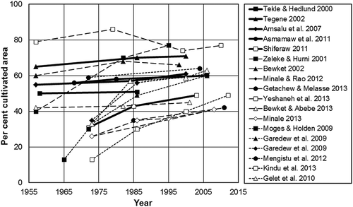
Figure 1. Percentage cultivated areas in different areas in Ethiopia according to remote sensing studies. Full lines show studies in South Wollo (Amsalu et al., Citation2007; Shiferaw, Citation2011; Tegene, Citation2002; Tekle & Hedlund, Citation2000), long hatches in north-western Ethiopia (Bewket, Citation2002; Bewket & Abebe, Citation2013; Getachew & Melesse, Citation2013; Minale, Citation2013; Minale & Rao, Citation2012; Yeshaneh et al., Citation2013; Zeleke & Hurni, Citation2001) and short hatches in southern (Garedew et al., Citation2009; Gelet et al., Citation2010; Kindu et al., Citation2013; D. Mengistu et al., Citation2012; A. Moges & Holden, Citation2009).
If access to agricultural land is limited, a growing population will result in a fragmentation of the cultivated land (Amsalu et al., Citation2007; Asmamaw, Mohammed, & Desta, Citation2011; Desta, Kassie, Benin, & Pender, Citation2000; D. Mengistu, Citation2008; T. Moges & Holden, Citation2008). However, explicit information on fragmentation is rare. Fragmentation can be expressed as changes over time in the average size of land per household based on census statistics (Amsalu et al., Citation2007). In a detailed study of a watershed close to the small town of Hayk in South Wollo, Mengistu, Waktola, & Woldetsadik (Citation2012) found small size of land holdings (0.7 ha in 2004) but also that they were divided into one to five plots with an average of two plots. The high pressure on cropland in the densely populated South Wollo is problematic and results in a non-sustainable situation for agriculturally based livelihoods (Atlas, Citation2006; Camfield & Roelen, Citation2013; Devereux & Sharp, Citation2004). The area has suffered from food shortage and has been dependent on food aid several times during the last decades (DRMFSS, Citation2013).
On the contrary, Boserup (Citation1965) claimed that reduced farm size encourages agricultural intensification. Headey, Dereje, Seyoum, and Taffese (Citation2014) have found evidence for this on national level in Ethiopia in terms of higher purchased input costs per hectare and more family labour with the result of higher yields and gross income per hectare. However, they feared that the welfare improvement is limited in relation to the expected population increase.
In order to mitigate the effect of rainfall variability and small farming areas, different rainwater harvesting practices have been used in Ethiopia for thousands of years (Abebe, Lasage, Alemu, Gowing, & Woldearegay, Citation2012; Alem, Citation1999; DRMFSS, Citation2013; Getachew & Melesse, Citation2013). Irrigation may have a substantial effect on crop production and household economy (Belay & Bewket, Citation2013) and is therefore an important factor for sustainable farming. After 1991, a national food security strategy was adopted for the development of different rainwater harvesting techniques, including rainwater harvesting ponds at village or household level (Amha, Citation2007). The small rainwater harvesting ponds provide water for multiple cropping and are generally regarded positive by farmers. However, the ponds have created health problems or problems related to the maintenance of the ponds (Awulachew et al., Citation2005).
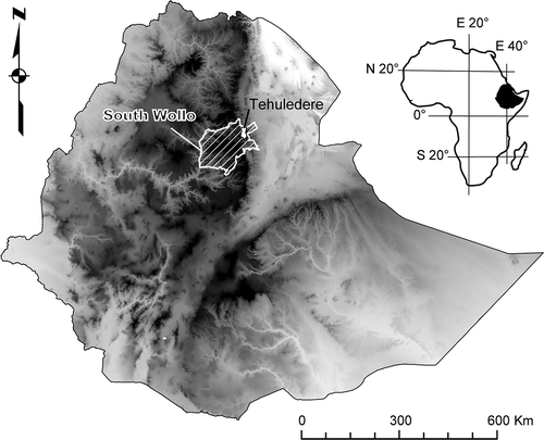
The catchment is an appropriate natural unit to analyse LULC changes and farmers’ livelihoods as it includes all the landscape components from the drainage divide to the valley floor (Tegene, Citation2002). In the present study, the catchment approach is applied to a small sub-catchment comprising most of Kete kebbele in South Wollo (). A kebbele is the smallest administrative unit in Ethiopia.
Figure 2. Location of the study area.
The aim of the study is to investigate LULC changes in a very densely populated part of Ethiopia where most land suited for agriculture is already used. We emphasise the available cultivated land and especially we analyse this asset in relation to a growing rural population (expressed as settlement area). To do this we introduce the same method to express annual changes as the one used in population studies to express the rate of annual change of cultivated land. In this way it is possible to compare directly population changes with changes in the available cultivated land. To put our results in an Ethiopian context, we calculate the corresponding rates of change from tables published in other studies of LULC in different parts of Ethiopia.
The study is performed by visual interpretation of LULC in aerial photos and satellite images from 1958, 2003 and 2013, field observations of LULC and soil erosion in 2001 as well as interviews with farmers on their livelihood. During a field trip in 2012, discussions with farmers and agricultural extension officers on the recent agricultural trends were made.
2. Geographical setting and description of the study area
Ethiopia is a large country covering 1.1 million km2. The topography is dominated by two highland areas surrounding the Great Rift Valley. Three quarters of the Ethiopian population live in the highlands at altitudes between 1500 and 2400 m.a.s.l. (Stock, Citation2012), which corresponds to the agro-ecological zone Weyna Dega (1500–2300 m.a.s.l.). The South Wollo Zone had a population density of 148 persons/km2 in 2007 (CSA, Citation2007), but population density varies considerably. The Tehuledere woreda (a woreda is the administrative unit between the zone and the kebbele) where the study area is situated had a population density that was twice as high (291 persons/km2) and on average there were 4.1 persons per household. According to CSA (Citation2007), almost half of the landholdings in South Wollo in 1991/92 were less than 0.5 ha and more than 99 % less than 2 ha (Tekle, Citation1999).
The study area is a sub-catchment that includes the greater part of Kete kebbele. It has a size of 14 km2 and is located between 1980 and 2600 m.a.s.l. on the S- to W-facing slopes of a river valley (). From the floodplain the slopes rise gently to about 2100 m.a.s.l., but above that altitude the slopes become increasingly steep. Loamy and clayey loamy Cambisols dominate the slopes, while clayey Vertisols are widespread on the floodplain. Sandy Fluvisols occur in areas close to the present river (Rosell & Olvmo, Citation2014).
In 2007, Kete had 5949 inhabitants (CSA, Citation2007). If yearly data of rural population growth rates for the whole of Ethiopia (World Bank, Citation2016c) are applied, the estimated population in Kete was about 1900 inhabitants in 1958 and 6600 in 2013. The small town of Hayk that is situated at the lower end of the sub-catchment also had a population of 1900 inhabitants in 1958 based on an exponential curve fit to census data for the years 1966, 1986 and 2000 given by Tegene (Citation2002) supplemented with census data for 2007 (CSA, Citation2007; Worldclimate, Citation2013). For the year 2013, the estimated population was 16,900, i.e. a rapid growth resulting in 2.5 times larger population in urban Hayk than in rural Kete.
The mean annual rainfall in the study area is approximately 1200 mm with most precipitation falling in July–September (the Kiremt season) and February–May (the Belg season). Monthly average temperatures vary between 17°C and 23°C (Worldclimate, Citation2013). Rain-fed agriculture is predominant in the study area. The most common crops are teff (Eragrostis tef) and sorghum (Sorghum bicolor). Teff and sorghum are adapted to both drought and water logging and tolerate a wide range of temperatures. Both crops are well suited to growth on clayey Vertisols (Prota, Citation2013a, Citation2013b).
3. Methods and material
The extent and changes in LULC were studied by aerial photos and satellite images but also details such as location of buildings and water harvesting ponds. During transect walks, randomly chosen points gave information that was not possible to obtain from satellite images. During these walks, randomly chosen farmers were also interviewed about their livelihood.
3.1. Aerial photos and satellite images
The interpretation of LULC was conducted using black and white aerial photos from 1958 and satellite images from 9–1-2003 to 9–3-2013 downloaded from Google Earth. The Kete sub-catchment was delimited by the water divide to the north and east, by creeks to the south and south-west and by the main road to the west. The water divide was delimited by height contours obtained from Aster altitude data (30 m resolution) using the contour tool in the ArcGIS software. LULC in 1958 and 2013 were analysed in the entire sub-catchment, and detailed studies were performed in the two areas of Dinso and Merfu ( and ) for 1958, 2003 and 2013. The detailed study areas were not delimited by any administrative border. Instead, pathways and distinct borders between cultivated areas were used.
Figure 3. The sub-catchment of Kete (study area) showing the observations points along the 10 transects used in the field study and locations of the two case study areas of Dinso and Merfu.
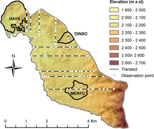
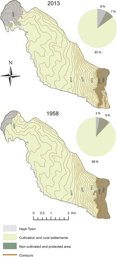
Figure 4. LULC changes in Kete kebbele in 1958 and 2013.
The aerial photos (V BNRB M73 IEG 3 January 1958 1, 10842–10845, scale 1:50,000) were digitised with a scanning resolution of 2400 dpi corresponding to a pixel size of 0.5 m. The mountainous landscape with height differences exceeding 600 m and the central projection of an aerial photo gave considerable geometrical distortions of the aerial photo, especially since the most mountainous part was located towards the frame of the photo. Thus, 105 georeference points were used to rectify the photo to fit in with the satellite images. The satellite image from 2003 was zoomed in to a level of 2300 m.a.s.l. and saved as .jpg files, which also gave a pixel resolution of 0.5 m. All digitising was done in the Quantum GIS open source software. The satellite images from 2013 were opened and handled as a base-layer map.
Satellite images from Google Earth were used since they are not only easy to download but also because of their geometrical properties. The Google Earth images are retrieved from the QuickBird-2 satellite launched in 2001 (eoPortal, Citation2015). This satellite had a sun-synchronous orbit at an altitude of 450 km. The spatial resolution is 0.61–0.72 m in panchromatic imagery and 2.4–2.6 m in multispectral imagery in four bands. The positional accuracy was tested by Mohammed, Ghazi, and Mustafa (Citation2013). Google Earth coordinates for 16 points in Khartoum, Sudan, were compared with GPS coordinates retrieved using a Trimble 1800. The Root Mean Square Error was 1.59 m. Thus, the spatial resolution and the positional accuracy make these Google Earth images useful in the study of LULC changes over time. When we compared the images, we noticed that the image from 2003 is displaced about 20 m to WNW compared to the one from 2013. This difference was adjusted in the GIS analysis.
The different LULC categories were distinguished based on differences in colour, shape and texture in the images. The interpretation of the images could be supported by knowledge from the observations made during the transect walks. In the satellite images the colours of the fields appear as brown if there is bare soil after harvest or before planting. Very often a lighter colour nuance is found between the fields, which reveal some type of soil and water conservation (SWC) measure such as terraces. Signs of gullies usually appear as lighter spots in cultivated fields and single or multiple channels running along the slope. Trees have round canopies and are usually found around houses. The high reflection of the tin-roofed houses makes them easy to identify. The traditional houses with grass roofs can be identified by roof alignment and shadow pattern. Even though the pixel resolution is the same in the black and white aerial photos as in the natural colour satellite images, it is more difficult to distinguish LULC categories in the air photos.
Four different land-use types were mapped: annual cultivation, perennial crops, grazing and tree-covered areas and settlements. These classes could be mapped visually with accuracy based on verification from the transect walks. Tin-roofed buildings were counted in 2003 and 2013. Further, rainwater harvesting ponds were identified in the satellite images from 2013 but not in 2003. An image from 2010 also showed rain water harvesting ponds but that image covered only the eastern part of the Kete area.
3.2. Calculations of rate of change
The common practice in studies of land use is to compare changes between 2 years available as aerial photos and/or satellite images as a percentage of the areas in the older image (see the references in ). Because of this it is difficult to compare changes when the time interval differs between the images as short intervals give small changes and longer intervals larger. Even if the change is divided by the number of years, the length of the period has an influence on the percentages. In this study, we use yearly growth to show the changes in analogy with population studies. In this way it is easy to compare changes in land use with different number of years between the images and also to compare land-use changes with population changes.
The yearly rate of change ∆C (%) is calculated as:
where Astart and Astop are the areas of a land use in the images from year Ystart and Ystop, respectively.
As a comparison, one can assume that the variable has increased to twice its original size in 30 years. According to the traditional calculation, the yearly increase is 3.3% and according to Equation (1) 2.3%, i.e. the traditional calculation gives higher values. On the other hand, if the variable only has half its value after 30 years, the traditional calculation shows a decrease with −1.7% while Equation (1) gives −2.3%, i.e. now the traditional calculation gives lower numerical value. With Equation (1) it does not matter if the variable is increasing or decreasing, the rate of change has the same numerical value.
3.3. Transects and observations
Transect walks to study LULC were performed during a 3-month stay in 2001. Fifty possible transects 100 m apart were identified (25 on the northern and 25 on the eastern slope) on the topographical map (Sheet ETH 4, 1139 D1, 1993, scale 1:50,000). Then five transects were randomly chosen on each of two slopes with the Microsoft Excel random-number generator. Along each transect, distances between the observation points from 50 up to 350 m were randomly generated. Observation points above the uppermost points with agricultural activity in each transect were not used. Totally 107 points were studied (). The south-eastern corner of the area was not covered by a transect due to a misunderstanding of the extent of the area. A handheld GPS was used to find the observation points. Observations were performed of LULC: cultivation, grazing, soil type, signs of erosion, SWC techniques, rural settlement and pathways.
3.4. Interviews
Interviews were performed during the transect walks in 2001. Forty interviews were conducted on site with four households randomly selected along each transect. In general, interviews were performed with heads of household. In a few cases, another member of the household was interviewed because the head was absent. Each interview lasted 45–60 min. A questionnaire was used but sometimes follow-up questions and discussions were needed to clarify the answers. The questions were about the farmers’ present situation and their perceptions of the changes they have noticed. The focus of the questions was on assets important to cultivation: natural assets (rainfall and soil productivity), physical assets (size of the farm land, access to an ox, SWC practices, irrigation and the number of soil types), human assets (number of people active in farming, the structure of the household, e.g. female- or male-headed households and the knowledge the farmers have of farming and livelihood strategies) and social assets (farming groups that some farmers participate in).
Finally, during 2 weeks in October 2012, more than 30 informal interviews with farmers, local authorities (kebbele board) and agricultural extension officers took place to get their perceptions of the recent changes in climate and agriculture.
4. Results
This section starts with the analysis of aerial photos and satellite images over the whole of Kete and in detail over two small areas (Dinso and Merfu) in 1958, 2003 and 2013. Then, details in LULC are shown by the transect walks in 2001. This is followed by the investigation in 2001 of the farmers’ perceptions of their natural and physical assets and of the agricultural change in a time perspective.
4.1. LULC changes, 1958–2013
The analysis of the whole Kete sub-catchment shows basic changes in the size of the town of Hayk, cultivated/settlement areas and uncultivated areas. On the other hand, the two small areas of Dinso and Merfu are studied in great detail, even buildings and ponds are identified. These two areas are situated at the same height above the valley floor but differ in soil type, topographical position and settlement structure.
4.1.1. LULC in the whole of Kete, 1958 and 2013
The interpretation of aerial photos from 1958 and satellite images from 2013 () reveal rather small changes in LULC since 1958.The areas used for rural settlements and agriculture in the whole of Kete including the town of Hayk have decreased with 3 percentage points. However, behind this rather small change there are other important changes. The extent of the closed area (Mengistu, Teketay, Hulten, & Yemshaw, Citation2005) in the south-eastern part of the kebbele has diminished in 2013, which means that cultivation has moved higher up on the hillside. On the other hand, the town of Hayk has expanded from 3% of the whole area in 1958 to 8% in 2013, which corresponds to an average annual increase of 1.9% (see Section 3.2 on how this rate of change is calculated). Thus, due to the loss of fertile land to the urban increase, farmers have been obliged to use land with lower fertility on high altitude for cultivation.
4.1.2. LULC changes in the Dinso area, 1958, 2003 and 2013
Dinso is situated at about 2050 m.a.s.l. on the slope of a low hill close to the water divide in the northern part of the Kete catchment (). The area covers approximately 27 ha, and the soils are generally Cambisols. Most houses are concentrated within a small area.
Cultivated land has declined from 85% in 1958 to 79% in 2003 ()) or −0.2% annually (). In 2003–2013, the loss of cultivated land was higher (−0.4% annually) but behind this there was an important change since the area for perennial crops increased from 3% to 5%. Due to the image quality, it was not possible to identify any perennial crops in 1958.
Table 1. Annual change (%) of LULC classes in Dinso and Merfu between 1958–2003 and 2003–2013, respectively.
Figure 5. LULC in 1958, 2003 and 2013 (a) the Dinso area and (b) the Merfu area.
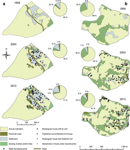
Most of the new settlement areas have been established in close connection to the already existing settlements ()). From 1958 until 2003, the settlement areas increased from 11.5% to 15% of the study area. This corresponds to an average increase of 0.6% annually (), but during 2003–2013 the increase was almost three times as high (2.4%). The new settlements in 2013 () were established in areas for annual cultivation but also in bushes/trees areas, e.g. in Dinso, 24% of the areas used for settlements in 2013 were in 2003 used for annual cultivation and 7% for trees/bushes/grazing. However, despite the need of wood for cooking and new buildings, the tree-covered area in the eastern part was the same in 2003 and in 2013. Ninety four per cent of the settlement areas in 2003 were still used for settlements in 2013 () but in 2013 6% were used for other purposes, i.e. annual cultivation and perennial crops.
Table 2. LULC (%) in 2003 of the areas that in 2013 were occupied by settlements.
Table 3. LULC (%) in 2013 of the areas that in 2003 were occupied by settlements.
The changes of settlement and cultivation areas imply that the cultivated area per household has totally decreased with −28% or on average with −0.8% annually between 1958 and 2003 (), if the settlement area per household is considered the same during the whole period.Footnote1 However, between 2003 and 2013 the cultivated area per household decreased with as much as −2.7% annually. On the other hand, in 2003 12 houses with tin roof were found, and in 2013 the number had increased to 47 ()), i.e. an increase with 5.8% annually. Another important change is the 15 rainwater harvesting ponds found in the image from 2013, while there were none in 2003.
4.1.3. LULC changes in the Merfu area, 1958, 2003 and 2013
The Merfu area is situated at about 2100 m.a.s.l. on the slope that rises 500 m additionally to the water divide. The selected area covers approximately 60 ha. The soils are generally Vertisol. The rural settlement is clustered over the selected area.
Although the settlements are more dispersed in Merfu compared to Dinso, the new settlements in Merfu are found close to already existing areas in most cases. The settlement areas increased from 6% in 1958 to 7% in 2003 ()), i.e. 0.3% annually (), which is a slower rate of expansion than that found in Dinso, but also in Merfu the growth of settlements increased clearly in 2003–2013 (1.9% annually). The new settlements in 2013 () were used for annual cultivation and for trees/bushes/grazing in 2003. Only 46% of the settlement area in 2003 was still used for settlements in 2013 (). Most of the settlement areas that have another LULC were used for trees/bushes/grazing and annual crops in 2013.
The total cultivated area had declined little from 69% in 1958 to 67% in 2003 (−0.1% annually) but the cultivated area was unchanged in 2003–2013 () and ). As in Dinso the area used for perennial crops increased, from 2% in 2003 to 6% in 2013. It is notable that a quarter of the total area in Merfu was used for grazing or was covered by bushes and trees in 1958, 2003 and 2013 and thus remained unchanged.
A calculation corresponding to the one in Dinso shows that the area that can be used for cultivation has diminished with −27% per household between 1958 and 2003 or −0.4% annually but in 2003–2013 with −1.9% annually (). In 2003, 18 houses with tin roof were found and in 2013, 52 ()), i.e. an increase with 4.0% annually. Eight rainwater harvesting ponds were observed in the satellite image from 2013.
4.2. Land use in Kete in 2001 according to the transects
Transect walks are an important complement to remote sensing as they give an opportunity to observe objects and phenomenon that are not easily recognised in aerial photos or satellite images. Of the 107 sites that were studied ( and ), 76% were used for cultivation, most of them with cereals and pulses, but also with cash crops such as khat and coffee (5%). Grazing was found to be the second most common land-use category (13%). Some sites had severe soil erosion that made the land impossible to use. Pathways and rural settlements were also found.
Table 4. LULC (%) mapped along the transects in Kete in the year 2001. The locations of transects and observation points are shown in Figure 3.
The soils found were Vertisols (59%), Cambisols (39 %) and Fluvisols (2%). At the bottom of the valley, which varies between plain areas to gentle slopes of a few degrees, the black Vertisols (locally called Walka) are found. Higher up on the slopes the red and stony Cambisols (Kayafer) were observed and along the creek at the valley floor brownish Fluvisols (Dellel).
Of the 80 points that were cultivated (corresponding to 76% in ) almost half of them (37 points) lacked any kind of SWC measures but two-thirds of them were on slopes below 5°. At the remaining 43 observation points, there were SWC measures such as terraces, stone-bunds, soil-bunds and cut-off drains. Soil erosion problems like gullies, rills, stony ground and washed away crop were identified at a total of 28 locations, i.e. a third of the cultivated area was degraded by visible soil erosion. This shows that soil erosion is a severe problem in the area, despite the fact that soil erosion measures have been undertaken in areas at risk.
4.3. Interviews in 2001 – perception of agriculture
The age of the interviewed farmers varied between 25 and 80 years. Four of the farms were headed by women. The households had between 2 and 12 members. The land available for each household is extremely small in Kete. The farmers that were interviewed had farm areas between 0.08 and 0.64 ha. The average size was 0.32 ha. Ten of the 40 households had 0.4 ha or more. Thus, the average area per household in Kete was only one-third of the Ethiopian average (Amsalu et al., Citation2007; Asmamaw et al., Citation2011; Deininger & Jin, Citation2006; Tegene, Citation2002; Tekle & Hedlund, Citation2000). In 2001, all farmers claimed that their yields had declined. However, only six out of the interviewed highlighted the problem with small farm area but all of them were among the interviewees having less than 0.32 ha of farm land. Half of the interviewees said that they used to have farm land in fallow, but not since the days when Haile Selassie was the emperor of the country, i.e. since the land reform in 1975 that was imposed after he was removed from office. A quarter of the interviewees claimed that the capability to sell cash crops is the biggest advantage someone could have in Kete. The few farmers who had access to the creek at the bottom of the valley said that they started to irrigate their fields after the drought in 1998 (). Irrigation was also seen as an opportunity to increase income as farmers could now grow vegetables and other cash crops to be sold in the nearby market place in Hayk.
Figure 6. A rainwater harvesting pond with the dimension of 10 × 8 m and a depth of 4 m (Photo: Staffan Rosell).
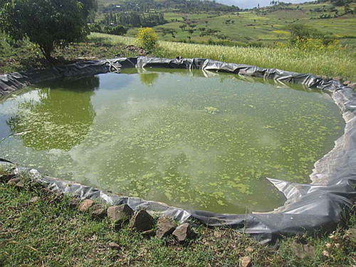
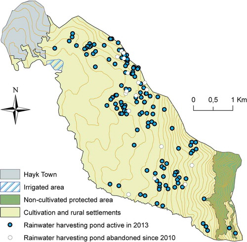
Figure 7. Map showing the distribution of rainwater harvesting ponds active in 2013 and ponds abandoned since 2010 as well as the approximate extension of land irrigated by river water.
4.4. A recent land-use change – rainwater harvesting ponds
An important change observed during the field visit in Kete in 2012 was the method of keeping water in rainwater harvesting ponds. A plastic sheet is placed at the bottom of the pond to prevent the water from infiltrating the soil (). On some ponds there are green algae covering the water, which leads to reduced evaporation. The water in the ponds can be stored for several months. Farmers fill up the ponds during the long rainy season in September, and the water can be used during January to March the following year. According to the farmers in Kete, the rainwater harvesting technique was introduced in 2009. The introduction was done with the aid of the local agricultural office that was able to subsidise the plastic cover. The investment costs could be covered within 2–3 years (according to conversations with farmers in Dinso 2012). According to one farmer, the use of the water for khat production was the most common in Kete. Khat is a cash crop that is sold in the nearby market in the town of Hayk, which means that a rainwater harvesting pond is a good possibility to get money for investments and daily needs.
The ponds are generally situated close to the settlements and areas with perennial crops. In 2003, there was not a single rainwater harvesting pond in Kete, but in 2013 the number of ponds was 155 (). Most of the ponds seem to have been established early after the introduction in 2009. In a Google Earth image from November 2010 that covered only the eastern half of Kete, 127 ponds could be observed. In that area another 20 ponds were found in March 2013 but 17 seemed to have disappeared, which means that about 15% of the ponds were abandoned during this one and a half years period.
5. Discussion
5.1. Land-use changes (LULC) between 1958 and 2013
The reduction of areas for cultivation is a major problem when farmers are dependent on rain-fed agriculture since that is the principle source of income. Deininger, Jin, Adenw, Gebre-Selassie, and Demeke (Citation2003) considered small farm areas as a problem for agricultural production. In Kete, there has been a slight loss of cultivated areas since 1958 while minor increases were found in other studies of land-use changes in South Wollo since the 1950s (Amsalu et al., Citation2007; Asmamaw et al., Citation2011; Tegene, Citation2002; Tekle & Hedlund, Citation2000), i.e. the area was intensively used for cultivation already in the late 1950s. On the other hand, the settlement areas have increased considerably, especially during the last decade of the study (1.9% and 2.4% annually, respectively, in the two detailed study areas). These figures can be compared with the Ethiopian rural population increase that was 2.0% in 2010 (World Bank, Citation2016c). Thus, the cultivated area per household decreased because of both population growth and losses of land for agriculture. In Dinso, the area per household diminished with −0.8% annually in 1958–2003 and −2.7% annually in 2003–2013 and in Merfu with −0.4% and −1.9% annually, respectively. These figures from the Kete area can be compared with that in the Kalu woreda (Tekle & Hedlund, Citation2000) some 30 km SSW of Kete with a very little increase in cropland area, and the decrease in cropland per capita was −1.5% annually between 1958 and 1986, if calculated in the same way as in Dinso and Merfu. Further calculations of the cropland area per capita show a decrease with −1.1% annually between 1973 and 2006 in an area west of Addis Ababa (Gelet, Suryabhagavan, & Balakrishnan, Citation2010) and with −3.5% annually between 1979 and 2010 in the north-western Highlands (Yeshaneh, Wagner, Exner-Kittridge, Legesse, & Blöschl, Citation2013). However, in 200 km south of Addis Ababa the cropland per capita was unchanged between 1973 and 2012 (Kindu, Schneider, Teketay, & Knoke, Citation2013). Thus, in some areas conversion to cropland can keep pace with the population increase, but generally the access to new land suitable for agriculture is limited, e.g. Amsalu et al. (Citation2007) and Tegene (Citation2002), which shows that fragmentation is a serious problem in most of Ethiopia.
In a few studies, the flows from one LULC class to others were analysed (Asmamaw et al., Citation2011; Gebrelibanos & Assen, Citation2015; Shiferaw, Citation2011; Tekle & Hedlund, Citation2000). However, it is only in the study of Tekle and Hedlund (Citation2000) that the rural settlements are separated from the cultivated areas. In the period 1958–1980, 65% of the rural settlements changed LULC class, which corresponds to an annual rate of – 3.7%. Half of the changes were to cultivated areas. In our study, the annual rate of change of the settlement areas in 2003–2013 was – 0.6% and –7.6% in Dinso and Merfo, respectively. Thus, the settlement structure is stable in Dinso while there are large changes in the use of land in Merfu. Also in the studies by Asmamaw et al. (Citation2011), Shiferaw (Citation2011) and Gebrelibanos and Assen (Citation2015), large flows between the LULC classes were observed. Maybe this can be considered as a fallow system/crop rotation that is beneficial to the agricultural yield in the long run.
With a high population and a need of a sufficient food production, cattle are pushed into bushes and areas suffering from erosion (DRMFSS, Citation2013). This was also the case in Kete where the transects in 2001 showed that grazing land was mostly found on marginal land for cultivation. As seen in the transect observations, soil erosion was also a problem since one-third of the cultivated plots showed damages despite the fact that almost all plots steeper than 5° were terraced. Soil erosion and especially loss of topsoil are a problem. A study by Rosell and Olvmo (Citation2014) suggests that the content of organic matter is low in the Kete area, which certainly has a negative influence on the harvest yield.
Recovery of the soil through fallowing is one way to maintain or increase soil productivity (Abera & Belachew, Citation2011) but there were no signs of fallow during the field work in 2001, and an old farmer claimed that it was abandoned many years ago. In fact, fallowing seems nowadays to be non-existing, not only in Kete but over most of Ethiopia (Amsalu et al., Citation2007; A. Moges & Holden, Citation2007; Shiferaw, Citation2011; Tegene, Citation2002; Tekle, Citation1999; Tekle & Hedlund, Citation2000; Zeleke & Hurni, Citation2001). The abandoned fallowing will result in diminishing yields which is attested by the interviewed farmers in Kete and also in the study by Gebrelibanos and Assen (Citation2015).
There are, however, some signs of improved livelihood in Kete. Areas with perennial crops are increasing fast although the areas are still small. Another sign of improved livelihood is the many new buildings with tin roofs.
5.2. Farmers adaptation and the future
The land available for each household is extremely small in Kete. The average land area per household in 2001 was only 0.32 ha, while the Ethiopian average was 1.1 ha (Deininger & Jin, Citation2006). Assuming that the decrease in farm area per household is −2% annually the average farm area was 0.25 ha in 2013. In 2001, 6 of the 40 households spontaneously said that the small land area was a problem However, in another area where most farmers had 0.6–1.0 ha of land, 72% of the farmers said that they could manage more land as a response to a direct question (Bewket, Citation2013). The administrative system in Ethiopia is based on the kebbeles. This limits the possibilities for farmers to have access to land outside the kebbele where they inherited the land from previous generations. Kebbele borders thus prevent the farmers from extending their farm area in neighbouring kebbeles. Instead, land is divided among the children, which increases the fragmentation (according to personal conversations with farmers). Thus, there is a strong pressure to produce a higher yield per hectare on the available land.
There is a considerable yield gap between the actual yield and what ought to be possible (Schneider & Anderson, Citation2010). To increase the productivity, it is possible to use chemical fertilisers (e.g. (Amsalu et al., Citation2007; Bantider, Hurni, & Zeleke, Citation2011; Garedew, Sandewall, Soderberg, & Campbell, Citation2009; T. Moges & Holden, Citation2008), sow in rows instead of broadcasting seeds (Asargew, Bitew, Asfaw, Liben, & Getahun, Citation2014; Vandercasteelen, Dereje, Minten, & Teffesse, Citation2014), improved seeds (Ayalew & Wondale, Citation2008; Bantider et al., Citation2011) and irrigation. On the national level, teff yield on private peasant holdings had increased from about 10 quintals per hectare in 2005/2006 to about 16 quintals per hectare in 2014/2015 (CSA, Citation2015), ). The corresponding sorghum yields are 15 and 23–24 quintals per hectare, respectively.
The tenure system where the state owns all land limits the willingness of the farmers to make long-term investments but there are campaigns to certify secure land rights to the farmers (Deininger, Ali, & Alemu, Citation2009). The influence of the land reform by the Derg regime in 1974 diminished land holdings considerably and in some cases by more than 75% (Assefa & Bork, Citation2016). Also, in the Hayk area land holdings have decreased. Two of our informants said they lost half of their area. However, since the land reform took place in the middle of the time span of our aerial photographs (1958) and satellite images (2003), it has not been possible to see consequences of the land reform compared to consequences of the growing population.
Irrigation has a long tradition in Ethiopia, but includes only a few per cent of the cultivated area (Bewket, Citation2009). After the drought in 1998 (Rosell & Holmer, Citation2015) a few farmers along the creek started with irrigation () as an important source to diversify the agriculture and grow cash crops such as sweet potato and carrots to sell in Hayk. In 2009, another source of water became available with the rainwater harvesting ponds. However, the management of the ponds is labour intensive, and there are estimates that only a quarter of the ponds continue to function after a few years (Abebe et al., Citation2012). Also, in Kete ponds disappeared. Fifteen per cent of the ponds observed in 2010 were abandoned in 2013.
Rosell and Holmer (Citation2015) have shown that it was possible to get a teff harvest during the Belg season every second year in Hayk as a long-term average but that in 1998–2012 only every third year had enough rain. Irrigation increases the possibilities to get a harvest also during years with low precipitation. Furthermore, irrigation encourages farmers to invest in perennial crops as shown by the increasing areas. The ponds are mostly used for growing khat as a cash crop to be sold at the local market. The long-term sustainability of growing khat in the area has to be analysed in coming years.
The infrastructure is important for the ability to sell crops (Dercon, Gilligan, Hoddinott, & Woldehanna, Citation2009). In Kete, the local market in Hayk is easily accessible but also the town of Dessie with almost 300,000 inhabitants 27 km from Hayk especially since the road through the mountainous area was much improved a couple of years ago.
Soil erosion is a threat to the development in Kete. Considerable areas show signs of erosion even if measures are taken to reduce it. Gully erosion is especially confined to cultivated areas as shown by e.g. Gebrelibanos and Assen (Citation2015).
6. Conclusions
On the one hand, the results provided in this study support the Malthusian perspective on the relationship between population growth, land resources and human welfare, that is, the amount of crop land per household decreases, the time available for the field to be fallow decreases and soil erosion increases in response to population growth. On the other hand, recent trends towards increased investment in land improvement, mainly by introducing different irrigation systems, point at a Boserupian development.
The change in livelihood strategy to cultivation of perennial cash crops enabled by these investments means that crops can be sold at the nearby local market to a high market value. Signs of increased incomes are indicated by, for instance, improvement of rural buildings, for example as shown by tin roofs. Urbanisation and investment in infrastructure are both advantageous to the rural economic development as both of these processes promote the capability to trade at local and regional markets.
However, the sustainability of irrigation systems is insecure and highlights the need for investment, political good will, policies and technical assistance programmes in order to maintain the irrigation systems. The importance of irrigation must also be stressed in regard to a climate-change perspective since irrigation may increase the yields during ‘normal’ years and help avoid failures during ‘dry’ years.
Since the turn of the millennium the number of children per woman has decreased rapidly, which is good in terms of population growth. However, life expectancy has increased with almost 20 years during the same time. The consequence of this will be a continued increase in population for several years until life expectancy levels off. Thus, the population pressure will continue to threaten food security. This calls for the need of higher crop yields by introducing more highly productive teff varieties or a change in cropping strategies to other drought resistant cereals. Even if urbanisation continues at an increased rate, the rural population will also continue to increase, and in the densely populated parts of Ethiopia, like south Wollo, fragmentation of the cultivated land will continue. In less populated parts of the region, cultivated areas may expand but deforestation and soil erosion must be carefully considered, otherwise the benefits of increased cropland can be lost.
Since land-use history and land-use strategies can vary considerably at a national, regional and even local scales, it is important, especially for local planners and agricultural extension officers, to monitor LULC dynamics also in small areas. By using remote sensing in combination with informant interviews, both the actual LULC trends and the drivers behind the changes can be understood.
Acknowledgements
We are grateful to the Ethiopian Mapping Agency who provided us with aerial photos. Several employees at the agricultural bureau in Hayk assisted with information about Kete kebbele and assisted in field. Ato Ayalew’s excellent interpreter skills and know-how about Kete village were most valuable and he cannot be thanked enough. Last but not least, thanks to all farmers in Kete who contributed with knowledge and information.
Disclosure statement
No potential conflict of interest was reported by the authors.
Additional information
Funding
Notes
1. Remarkably, to calculate the percentage change of farm area per household, it is not necessary to know the farm area per household if it is assumed that the average size in the settlement area per household has not changed during the studied time period.
References
- Abebe, A., Lasage, R., Alemu, E., Gowing, J., & Woldearegay, K. (2012). Opportunities for building on tradition – time for action. In W. Critchley & J. Gowing (Eds.), Water harvesting in Sub-Saharan Africa (pp. 70–84). London and New York: Eathscan from Routledge.
- Abera, Y., & Belachew, T. (2011). Effects of landuse on soil organic carbon and nitrogen in soils of Bale, Southeastern Ethiopia. Tropical and Subtropical Agroecosystems, 14, 229–235.
- Alem, G. (1999): Rainwater harvesting in Ethiopia: An overview. Proceedings of the 25th WEDC Conference – Integrated development for water supply and sanitation, Addis Ababa, Ethiopia. 387–390. Retrieved from http://wedc.lboro.ac.uk/resources/conference/25/387.pdf
- Amha, R. (2007). Impact assessment of rainwater harvesting ponds: The case of Alaba Woreda, Ethiopia. Paper presented at the impact of irrigation on poverty and environment in Ethiopia, Addis Ababa. Retrieved from https://cgspace.cgiar.org/bitstream/handle/10568/688/Thesis_AmhaImpact.pdf?sequence=1
- Amsalu, A., Stroosnijder, L., & de Graaff, J. (2007). Long-term dynamics in land resource use and the driving forces in the Beressa watershed, highlands of Ethiopia. Journal of Environmental Management, 83, 448–459. doi:10.1016/j.jenvman.2006.04.010
- Asargew, F., Bitew, Y., Asfaw, M., Liben, M., & Getahun, W. (2014). Row spacing and fertilizer rate on yield and yield components of tef Eragrostis tef (Zucc.) Trotter) under transplanting planting method. Journal of Biology, Agriculture and Healthcare, 4, 133–136.
- Asmamaw, L., Mohammed, A., & Desta, L. (2011). Land use/cover dynamics and their effects in the Gerado catchment, northeastern Ethiopia. International Journal of Environmental Studies, 68, 883–900A. doi:10.1080/00207233.2011.637701
- Assefa, E., & Bork, H.-R. (2016). Dynamics and driving forces of the agricultural landscapes in Southern Ethiopia – a case study of the Chencha and Abra Minch areas. Journal of Land Use Science, 11, 248–293.
- Atlas. (2006). Atlas of rural Ethiopian economy: Addis Ababa, Ethiopia: Central Statistical Agency: Ethiopian Development Research Institute. Washington, DC USA: International Food Policy Research Institute.
- Awulachew, S., Merrey, D., Kamara, A., Van Koppen, B., Penning De Vries, F., Boelee, E., & Makombe, G. (2005). Experiences and opportunities for promoting small–scale/micro irrigation and rainwater harvesting for food security in Ethiopia. Colombo, Sri Lanka. Addis Ababa, Ethiopia: International Water Management Institute, Retrieved from http://www.iwmi.cgiar.org/Publications/Working_Papers/working/WOR98.pdf
- Ayalew, H., & Wondale, L. (2008). Performance and yield stability of selected tef (Eragrostis tef (Zucc.) Trotter) lines in western Amhara region. Paper presented at the Third Annual Regional Conference on Completed Crop Research Activities. Retrieved from https://www.researchgate.net/publication/275042967_Performance_and_yield_stability_of_selected_tef_Eragrostis_tefZuccTrotter_lines_in_western_Amhara_region
- Bantider, A., Hurni, H., & Zeleke, G. (2011). Responses of rural households to the impacts of population and land-use changes along the Eastern Escarpment of Wello, Ethiopia. Norsk Geografisk Tidsskrift-Norwegian Journal of Geography, 65, 42–53. doi:10.1080/00291951.2010.549954
- Belay, M., & Bewket, W. (2013). Traditional irrigation and water management practices in Highland Ethiopia: Case study in Dangila Woreda. Irrigation and Drainage, 62, 435–448.
- Bewket, W. (2002). Land cover dynamics since the 1950s in Chemoga Watershed, Blue Nile Basin, Ethiopia. Mountain Research and Development, 22(3), 263–269. doi:10.1659/0276-4741(2002)022[0263:Lcdsti]2.0.Co;2
- Bewket, W. (2009). Rainfall variability and crop production in Ethiopia - Case study in the Amhara region. Paper presented at the 16th International Conference of Ethiopian Studies, Trondheim, Norway. Retrieved from http://hpccc.gov.in/PDF/Agriculture/Rainfall%20Variability%20and%20Crop%20production%20in%20Ethiopia%20Case%20study%20in%20the%20Amhara%20Region.pdf
- Bewket, W. (2013). Farmers’ knowledge of soil erosion and control measures in the northwestern highlands of Ethiopia. African Geographical Review, 30, 53–70. doi:10.1080/19376812.2011.10539143
- Bewket, W., & Abebe, S. (2013). Land-use and land-cover change and its environmental implications in a tropical highland watershed, Ethiopia. International Journal of Environmental Studies, 70, 126–139. doi:10.1080/00207233.2012.755765
- Boserup, E. (1965). The conditions of agricultural growth. The economics of agrarian change under population pressure. London: Geoge Allen & Unwin Ltd. Retrieved from http://www.biw.kuleuven.be/aee/clo/idessa_files/Boserup1965.pdf
- Camfield, L., & Roelen, K. (2013). Chronic poverty in rural Ethiopia through the lens of life history. Journal of Human Development and Capabilities, 14, 581–602. doi:10.1080/19452829.2013.827638
- Crummey, D. (1998). Deforestation in Wällo: Process or illusion? Journal of Ethiopian Studies, 31, 1–41.
- CSA. (2007, 23.02.16). Population size and characteristics. Retrieved from http://www.csa.gov.et/newcsaweb/images/documents/surveys/Population%20and%20Housing%20census/ETH-pop-2007/survey0/data/Doc/Reports/STATISTICAL_AMHARA/Statistical_Amhara_PartI.pdf
- CSA. (2015). Agricultural sample survey - time series data for national & regional level. Retrieved from http://www.csa.gov.et/images/general/news/agss_time_series%20report
- Deininger, K., Ali, D., & Alemu, T. (2009). Impact of land certification on tenure security, investment, and land markets: Evidence from Ethiopia. Retrieved from http://www.rff.org/files/sharepoint/WorkImages/Download/EfD-DP-09-11.pdf
- Deininger, K., & Jin, S. (2006). Tenure security and land-related investment: Evidence from Ethiopia. European Economic Review, 50, 1245–1277. doi:10.1016/j.euroecorev.2005.02.001
- Deininger, K., Jin, S., Adenw, B., Gebre-Selassie, S., & Demeke, M. (2003). Market and nonmarket transfers of land in Ethiopia – Implications for efficiency, equity, and nonfarm development. Retrieved from http://www-wds.worldbank.org/external/default/WDSContentServer/WDSP/IB/2003/04/05/000094946_03032604030152/Rendered/PDF/multi0page.pdf
- Dercon, S., Gilligan, D.O., Hoddinott, J., & Woldehanna, T. (2009). The impact of agricultural extension and roads on poverty and consumption growth in fifteen Ethiopian villages. American Journal of Agricultural Economics, 91, 1007–1021. doi:10.1111/j.1467-8276.2009.01325.x
- Desta, L., Kassie, M., Benin, S., & Pender, J. (2000). Land degradation and strategies for sustainable development in the Ethiopian highlands: Amhara region. Nairobi, Kenya: ILRI (International Livestock Research Institute). Retrieved from http://pdf.usaid.gov/pdf_docs/pnacm308.pdf
- Devereux, S., & Sharp, K. (2004). Destitution in Wollo (Ethiopia): Chronic poverty as a crisis of household and community livelihoods. Journal of Human Development, 5, 227–247. doi:10.1080/1464988042000225140
- DRMFSS. (2013, 23 February 2016). Year of assistance 1994–2013. Retrieved from http://www.dppc.gov.et/downloadable/map/Thematic%20maps/2013_Appeal/Year%20of%20assistance_1st%20half-2013.pdf
- eoPortal. (2015). QuickBird-2. Retrieved from https://directory.eoportal.org/web/eoportal/satellite-missions/q/quickbird-2
- Garedew, E., Sandewall, M., Soderberg, U., & Campbell, B. (2009). Land-use and land-cover dynamics in the central rift valley of Ethiopia. Environmental Management, 44(4), 683–694. doi:10.1007/s00267-009-9355-z
- Gebrelibanos, T., & Assen, M. (2015). Land use/land cover dynamics and their driving forces in the Hirmi watershed and its adjacent agro-ecosystem, highlands of Northern Ethiopia. Journal of Land Use Science, 10, 81–94. doi:10.1080/1747423X.2013.845614
- Gelet, M., Suryabhagavan, K., & Balakrishnan, M. (2010). Land-use and landscape pattern changes in Holeta-Berrga watershed, Ethiopia. International Journal of Ecology and Environmental Sciences, 36, 117–132.
- Getachew, H., & Melesse, A. (2013). The impact of land use change on the hydrology of the Angereb watershed, Ethiopia. International Journal of Water Sciences, 1(4), 1–7.
- Headey, D., Dereje, M., Seyoum, A., & Taffese, S. (2014). Land constraints and agricultural intensification in Ethiopia: A village-level analysis of high-potential areas. Food Policy, 48, 129–141. doi:10.1016/j.foodpol.2014.01.008
- Kindu, M., Schneider, T., Teketay, D., & Knoke, T. (2013). Land use/land cover change analysis using object-based classification approach in Munessa-Shashemene landscape of the Ethiopian highlands. Remote Sensing, 5(5), 2411–2435. doi:10.3390/Rs5052411
- Mengistu, D. (2008). Remote sensing and GIS-based land use and land cover change detection in the upper Dijo river catchment, Silte zone, southern Ethiopia. Retrieved from http://www.svt.ntnu.no/geo/Doklager/Acta/SerieA_23_Daniel_Mengistu.pdf
- Mengistu, D., Waktola, D., & Woldetsadik, M. (2012). Detection and analysis of land-use and land-cover changes in the Midwest escarpment of the Ethiopian Rift Valley. Journal of Land Use Science, 7, 239–260. doi:10.1080/1747423X.2011.562556
- Mengistu, T., Teketay, D., Hulten, H., & Yemshaw, Y. (2005). The role of enclosures in the recovery of woody vegetation in degraded dryland hillsides of central and northern Ethiopia. Journal of Arid Environments, 60, 259–281. doi:10.1016/j.jaridenv.2004.03.014
- Minale, A. (2013). Retrospective analysis of land cover and use dynamics in Gilgel Abbay watershed by using GIS and remote sensing techniques, Northwestern Ethiopia. International Journal of Geosciences, 4, 1003–1008. doi:10.4236/ijg.2013.47093
- Minale, A., & Rao, K. (2012). Impacts of land cover/use dynamics of Gilgel Abbay catchment of Lake Tana on climate variability, Northwestern Ethiopia. Applied Geomatics, 4, 155–162. doi:10.1007/s12518-012-0092-2
- Moges, A., & Holden, N. (2007). Farmers’ perceptions of soil erosion and soil fertility loss in southern Ethiopia. Land Degradation and Development, 18, 543–554. doi:10.1002/ldr.795
- Moges, A., & Holden, N. (2009). Land cover change and gully development between 1965 and 2000 in Umbulo Catchment, Ethiopia. Mountain Research and Development, 29, 265–276. doi:10.1659/mrd.00015
- Moges, T., & Holden, S. (2008). Soil fertility in relation to slope position and agricultural land use: A case study of Umbulo Catchment in Southern Ethiopia. Environmental Management, 42, 753–763. doi:10.1007/s00267-008-9157-8
- Mohammed, N., Ghazi, A., & Mustafa, H. (2013). Positional accuracy testing of Google Earth. International Journal of Multidiciplinary Sciences and Engineering, 4, 6–9.
- Omiti, J., Parton, K., Sinden, J., & Ehui, S. (1999). Monitoring changes in land-use practices following agrarian de-collectivism in Ethiopia. Agriculture, Ecosystems & Environment, 72, 111–118. doi:10.1016/S0167-8809(98)00162-5
- Prota. (2013a). Sorghum bicolor (L.) Moench. Retrieved from http://www.prota4u.org/protav8.asp?h=M4,P6,P6&t=sorghum,bicolor,Ethiopia&p=Sorghum+bicolor#Synonyms
- Prota. (2013b). Eragrostis tef (Zucc.) Trotter. Retrieved from http://www.prota4u.org/protav8.asp?h=M4,tef&p=Eragrostis%20tef
- Rosell, S., & Holmer, B. (2015). Eratic rainfall and its consequences for cultivation in two adjacent areas in South Wollo, Ethiopia. Norsk Geografisk Tidsskrift - Norwegian Journal of Geography, 69, 36–48. doi:10.1080/00291951.2014.992805
- Rosell, S., & Olvmo, M. (2014). A geographical view of soil productivity parameters in West Shewa and South Wollo – Case studies from Wenchi woreda and Tehuledere woreda, Ethiopia. Scottish Geographical Journal, 130, 51–66. doi:10.1080/14702541.2013.820027
- Schneider, K., & Anderson, L. (2010). Yield gap and productivity potential in Ethiopian agriculture: Staple grain and pulses. Evans School Policy Analysis and Research (EPAR), Brief No 98. Retrieved from https://evans.uw.edu/sites/default/files/Evans_UW_Request_98_Productivity_of_Ethiopian_Ag_October-12-2010.pdf
- Shiferaw, A. (2011). Evaluating the land use and land cover dynamics in Borena woreda of South Wollo highlands, Ethiopia. Journal of Sustainable Development in Africa, 13, 87–107.
- Stock, R. (2012). Africa South of the Sahara: A geographical interpretation (3rd ed.). New York: Guilford Publications.
- Tegene, B. (2002). Land-cover/land-use changes in the Derekolli Catchment of the South Welo Zone of Amhara Region, Ethiopia. Eastern Africa Social Science Research Review, 18, 1–20. doi:10.1353/eas.2002.0005
- Tekle, K. (1999). Land degradation problems and their implications for food shortage in South Wello, Ethiopia. Environmental Management, 23(4), 419–427. doi:10.1007/s002679900197
- Tekle, K., & Hedlund, L. (2000). Land cover changes between 1958 and 1986 in Kalu District, Southern Wello, Ethiopia. Mountain Research and Development, 20(1), 42–51. doi:10.1659/0276-4741(2000)020[0042:Lccbai]2.0.Co;2
- Vandercasteelen, J., Dereje, M., Minten, B., & Teffesse, A. (2014). Perceptions, impacts and rewards of row planting of teff. Ethiopia Strategy Support Program (ESSP), Working paper 65, 21 p. Retrieved from https://feb.kuleuven.be/drc/licos/publications/dp/dp-350
- World Bank, (2016a). Ethiopia population total. Retrieved from https://www.quandl.com/data/WORLDBANK/ETH_SP_POP_TOTL-Ethiopia-Population- total
- World Bank, (2016b), Ethiopia population growth annual. Retrieved from https://www.quandl.com/data/WORLDBANK/ETH_SP_POP_GROW-Ethiopia-Population- growth-annual
- World Bank, (2016c). Ethiopia rural population growth annual. Retrieved from https://www.quandl.com/data/WORLDBANK/ETH_SP_RUR_TOTL_ZG-Ethiopia-Rural- population-growth-annual
- Worldclimate. (2013). Climate data for 11°N 39°E Retrieved from http://www.worldclimate.com/cgi-bin/grid.pl?gr=N11E039
- Yeshaneh, E., Wagner, W., Exner-Kittridge, M., Legesse, D., & Blöschl, G. (2013). Identifying land use/cover dynamics in the Koga Catchment, Ethiopia, from multi-scale data, and implications for environmental change. Journal of Geo-Information, 2, 302–323.
- Zeleke, G., & Hurni, H. (2001). Implications of land use and land cover dynamics for mountain resource degradation in the Northwestern Ethiopian highlands. Mountain Research and Development, 21(2), 184–191. doi:10.1659/0276-4741(2001)021[0184:Iolual]2.0.Co;2