
ABSTRACT
With increased affluence worldwide, planning for and preserving land for agriculture and conservation have become important goals in many communities. In Hawaii, the identification and designation of Important Agricultural Land (IAL) was first proposed at the 1978 Hawaii Constitutional Convention and approved by voters the same year. The state is required to conserve and protect agricultural lands, promote diversified agriculture, increase agricultural self-sufficiency, and assure the availability of agriculturally suitable lands. Act 183 in 2005 extended these efforts by defining IAL. The law established eight criteria to evaluate IAL and created county-led and landowner-initiated processes for designating IAL. It also specified policies for promoting agricultural production and identified landowner incentives for the designation of IAL. A central challenge facing policymakers is how to operationalize and implement these land use policies. This paper describes methods used to operationalize Act 183. We use fast feedback (i-Clicker technology) devices for capturing stakeholder preferences and geographic information systems and community mapping to visualize policy impacts and integrate community feedback. The methods developed in this paper have broad applications to jurisdictions around the world looking for data-driven approaches to planning and designating land uses according to legislative mandates or administrative requirements.
Introduction
Protection of agricultural lands is an important land use challenge around the world. Communities want to protect agricultural lands from development and promote food security (Jiang, Deng, & Seto, Citation2013). When economic benefit from development exists, there is increased pressure to convert agricultural lands to other uses (Lichtenberg & Ding, Citation2008). Conversion of productive agricultural lands into urban and industrial uses has occurred in China (Jiang et al., Citation2013; Lichtenberg & Ding, Citation2008), Indonesia (Partoyo & Shrestha, Citation2013), Vietnam (Pham, Pham, Tong, Nguyen, & Pham, Citation2015), Israel (Maruani & Amit-Cohen, Citation2010), New Zealand (Curran-Cournane, Vaughan, Memon, & Fredrickson, Citation2014), Europe (Mazzocchi, Sali, & Corsi, Citation2013), and the United States (Kuminoff, Sokolow, & Sumner, Citation2001). Urbanization of agricultural lands is widespread. Urban sprawl has been a contributing factor. Between 1987 and 1997, farmland in the United States decreased by over 32 million acres (Rashford, Weber, Lewis, & Evonuk, Citation2003). Policy initiatives and legislation to reverse these trends have been introduced as have methods to assess impacts and support decision processes, including geographic information systems (GIS), remote sensing, multi-criteria analysis, scenario modeling, and analytic hierarchy process (AHP). Recent advance includes combining GIS with multi-criteria decision processes (Mendas & Delali, Citation2012; Romano, Dal Sasso, Trisorio Liuzzi, & Gentile, Citation2015), AHP (Akıncı, Özalp, & Turgut, Citation2013; Widiatmaka, Ambarwulan, & Sudarsono, Citation2016; Zolekar & Bhagat, Citation2015), remote sensing (AbdelRahman, Natarajan, & Hegde, Citation2016; El Baroudy, Citation2016; Shalaby, Ali, & Gad, Citation2012), and scenario modeling (Partoyo & Shrestha, Citation2013; Swetnam et al., Citation2011). This paper combines GIS, rapid response technology (i-Clickers), and AHP to operationalize legislative criteria to evaluate agricultural lands in the island context of Kauai, Hawaii.
GIS has been used with other methods to support policies for preserving agricultural lands. Shalaby et al. (Citation2012) have used GIS to identify risk of urban sprawl in agricultural lands in Qalubiya Governorate of Egypt. Multispectral remote sensing and GIS were used with expert knowledge, groundtruthing, and topographic map interpretations to identify urbanization pressures on the most fertile agricultural lands (Shalaby et al., Citation2012). Partoyo and Shrestha (Citation2013) used simulation modeling to predict farmland loss caused by urbanization in Yogyakarta, Indonesia, and found that lack of policy interventions can lead to significant losses of agricultural land. Another study by Widiatmaka et al. (Citation2016) combined GIS and AHP to operationalize seven criteria and associated sub-criteria to identify suitable land for agriculture in the hinterlands of Jakarta, Indonesia. They found that only 16.7% of suitable lands was designated for agriculture of the 87.5% land of agricultural lands in Bogor Regency (Widiatmaka et al., Citation2016). AHP allows individuals or groups to define problems, organizing choices into a structured approach to decision-making (Niroula & Thapa, Citation2005; Saaty, Citation1982). It can measure quantitative and qualitative factors (De la Rosa, Mayol, Diaz-Pereira, Fernandez, & de la Rosa, Citation2004; Saaty, Citation1980) and can be integrated with other multi-criteria decision-making tools (Vaidya & Kumar, Citation2006) to collect stakeholder preferences using a weighted combination approach (Romano et al., Citation2015).
Land suitability analysis has been used by planners to determine interactions between location, development actions, and environmental resources (Collins, Steiner, & Rushman, Citation2001). It has evolved from simple processes to more complex approaches that simultaneously consider many variables to support decision-making. GIS has been used for land-suitability analysis to facilitate decision-making. It is useful for both techno-positivist and participatory approaches (Kalogirou, Citation2002). It can support analysis of alternatives and plans (Kalogirou, Citation2002). GIS-based land-suitability analysis has been used for decision-making involving the location of agricultural activities (El Baroudy, Citation2016; Mokarram & Aminzadeh, Citation2009), evaluating development opportunities (Chandio, Matori, Yusof, Talpur, & Aminu, Citation2014), siting fuel stations (Collins et al., Citation2001), animal waste disposal facilities (Basnet, Apan, & Raine, Citation2001), and public parks (Chandio, Matori, Lawal, & Sabri, Citation2011). GIS is often used to widen participation to support community planning and decision-making. The integration of GIS and multi-criteria analysis is notably being practiced in different domains of land-use planning (Arciniegas & Janssen, Citation2009). It has been used to map community preferences with multi-criteria analysis to prioritize lands for conservation (Strager & Rosenberger, Citation2006). Recently, innovative technologies have been used to collect community preferences and choices in the course of land use planning. A touch table is being used to identify planning problems, evaluate planning choices, and maximize personal values and total values of a plan (Arciniegas & Janssen, Citation2009). The touch table is a touch-enabled screen used to support stakeholder collaboration through common visualization and spatial information handling (Arciniegas & Janssen, Citation2009).
i-Clicker technology is described as an ‘Audience Response Systems’ in research in the health sector (Miller & Hartung, Citation2012) and tourism (Keske & Smutko, Citation2010). It is a technological tool for promoting interactive learning (Miller & Hartung, Citation2012). We refer to this technology as ‘fast feedback’ in this research because it captures the use of i-Clickers and soliciting rapid responses, prioritizing choices, voting, and reaching agreement among diverse stakeholders. We combine fast-feedback technology, GIS, and decision-making models to weigh different alternatives and stakeholder preferences.
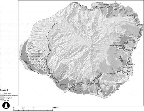
The objective of this paper is to describe a method for operationalizing legislative criteria for IAL. Operationalizing is defined as the set of procedures for interpreting and putting into practice the laws, rules, and determinations for making IAL designations. Many studies use criteria-based land-evaluation approaches. This project uses criteria prescribed by state legislation and operationalizes them for the island of Kauai () in the state of Hawaii. Using GIS, fast-feedback technology (i-Clickers), AHP, and interactive community processes (mapping, surveys and group deliberation), we operationalize the eight legislative criteria and presented alternatives to the community and decision makers. The study team worked closely with a stakeholder advisory committee and conducted multiple community meetings to operationalize, rank, and weigh these criteria in order to determine the appropriate lands for designation as IAL.
Important Agricultural Lands legislation
Different policies are used to manage urban growth and protect farmland (Bengston, Fletcher, & Nelson, Citation2004). Maryland protects agricultural lands from development through the Maryland Agricultural Land Preservation Foundation, established in 1977 under the Code of the Public Laws of Maryland, Title 2 and Subtitle 5. From 1977 to 2013, the state protected 286 thousand acres of agricultural lands through the purchase of easements (Maryland Agricultural Land Preservation Foundation, Citation2013). Pennsylvania established an executive order protecting agricultural lands in 2003 (Governor’s Office, Citation2003). Oregon initiated a state land-use planning program in 1973. The Land Conservation and Development Act protects forest and agricultural lands (Gosnell, Kline, Chrostek, & Duncan, Citation2010; Oregon State Legislature, Citation2013). British Columbia, Canada, established an Agricultural Land Commission in 1973 to preserve agricultural lands and establish family farms (Androkovich, Citation2013). Hawaii has a constitutional mandate to protect agricultural lands. Act 183 advanced the mandate by defining Important Agricultural Land (IAL), establishing criteria to evaluate potential IAL, establishing county-led and landowner-initiated processes for designation of IAL, specifying policies for promoting agricultural production, and identifying incentives for the designation of IAL. Although the law established criteria for IAL designation, there was need to develop a systematic process at the county level for evaluating and designating IAL.
There are previous studies evaluating the suitability of agricultural lands in Hawaii. The Land Study Bureau (LSB) conducted a rating of the productivity of agricultural lands between 1965 and 1972. Based on soil, water, and topographic characteristics, land was divided into five categories (A–E), where A was the most productive land and E was the least productive (Land Study Bureau, Citation1967). A second study in 1977 identified Agricultural Lands of Importance to the State of Hawaii (ALISH). This effort involved mapping agricultural lands and classifying them into prime, unique, and locally important (State Department of Agriculture, Citation1977). Act 183 in 2005 established eight criteria for IAL with the intent of creating a strategic agricultural land base that could support a diversity of agricultural activities and opportunities, expand agricultural income and job opportunities, and increase agricultural self-sufficiency for current and future generations. The eight criteria were as follows:
Land currently used for agricultural production (‘currently in farming’);
Land with soil qualities and growing conditions that support agricultural production of food, fiber, or fuel- and energy-producing crops (‘soil qualities’);
Land identified under agricultural productivity rating systems, such as the ALISH system adopted by the Board of Agriculture on 28 January 1977 (‘Rating systems’);
Land types associated with traditional-native Hawaiian agricultural uses, such as taro cultivation, or unique agricultural crops and uses, such as coffee, vineyards, aquaculture, and energy production (‘traditional and unique farming’);
Land with sufficient quantities of water to support viable agricultural production (‘water availability’);
Land whose designation as IAL is consistent with general, development, and community plans of the county (‘county plans’);
Land that contributes to maintaining a critical land mass important to agricultural operating productivity (‘critical land mass’); and
Land with or near support infrastructure conducive to agricultural productivity, such as transportation to markets, water, or power (‘supporting infrastructure’).
According to the law, agricultural lands that meet any of the eight criteria can be given consideration provided that its designation meets the purposes of the State Constitution and objectives and policies for IAL. Act 183 established two different processes in which IAL could be designated. A landowner or farmer can petition the Land Use Commission (LUC) for designation of IAL. To date, a total of 16,618 ac of agricultural land have been voluntarily designated by landowners on Kauai (Hawaii State GIS Program, Citation2014). Counties can also recommend lands for designation by the LUC. These lands exclude those designated for urban use by state land use boundary, county zoning, or community or general plan designations. The county process requires public involvement in identifying suitable lands that meet the criteria of the IAL legislation.
The University of Hawaii was retained by the County of Kauai to develop the process as well as collect and manage data to support the designation of IAL. Research, data collection, interviews with experts, farmers and members of the public were conducted and shared with the stakeholder advisory committee and at community meetings across the county. Data and methods were reviewed by the stakeholder advisory committee and also shared with the public at community meetings and through the project website.
Methods for evaluating and classifying IALs
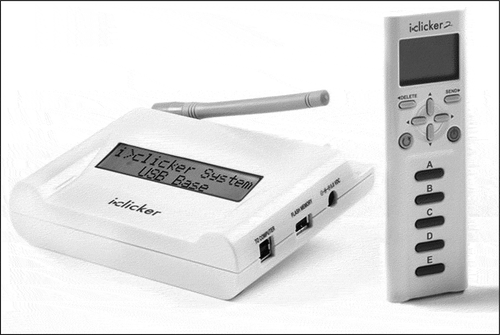
The process for evaluating and classifying agricultural lands involved close interactions with an advisory committee. The stakeholder advisory committee, established by the County of Kauai, included representation from the following groups: farmers, landowners, agricultural entrepreneurs, community leaders, agricultural technical experts, and agricultural extension agents. A total of 18 meetings were organized with the stakeholder advisory committee to review, operationalize, and rank each legislative criterion. The stakeholder advisory committee identified more than 20 sub-criteria to operationalize the 8 general criteria. Six regional meetings were also conducted. These meetings provided an opportunity to share results, verify findings, and to receive further feedback from the community. Fast-feedback devices (i-Clickers) for quickly capturing and displaying participant priorities and preferences were used to evaluate and rank options in both the stakeholder advisory committee meetings and in the large public meetings. This technology has been used to promote active learning in classrooms, engage large audiences, and to gather data on community choices and perceptions (Keske & Smutko, Citation2010). It has also been used for legislative decision-making (Theobald et al., Citation2000), transportation safety choices (Janssen, van Herwijnen, Stewart, & Aerts, Citation2008), and public health research (Jankowski, Citation2009). Fast-feedback technology is useful in two ways. First, it can be used to measure support or opposition to proposals in a large group with diverse interests. Second, the technology can allow for the anonymity of participants’ choices as each participant can vote independently of others. It can be difficult track differences in large meetings (McCown, Citation2002). This technology allows for quick and silent voting and the results can be shared immediately to inform discussion and deliberation. This approach provides both an opportunity for fast feedback and a record useful for analysis and comparisons across different communities and over time.
The i-Clickers can be set up to work with computer-based presentations. The hardware includes a hand held device (remote) and a base station for transmitting and receiving information (). The base station can be connected to the computer and the remote devices are distributed to the participants. A special remote is used by the presenter to control the timing of voting and the displays of results. Questions are presented and participants are asked to vote by pressing a button. Information can be shared and discussed with participants prior to voting. Results from the meeting are saved and can be further analyzed later. For this study, the data collected through i-Clickers were shared initially with stakeholder advisory committee members and then later analyzed using AHP.
Figure 1. Study area.
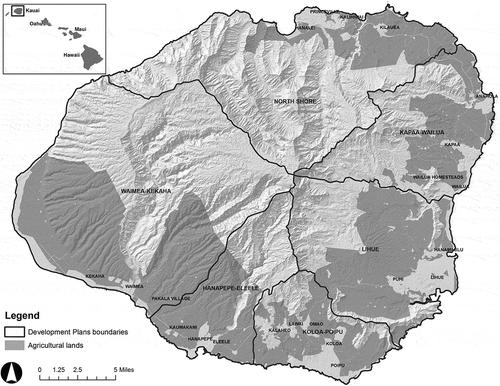
Figure 2. Fast-feedback technology (i-Clicker).
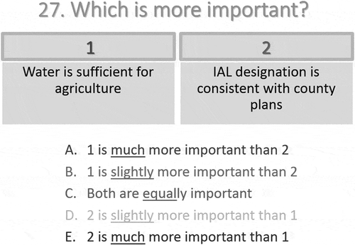
Scenario evaluation has been conducted using i-Clickers in previous research (Matthies, Giupponi, & Ostendorf, Citation2007). The technology was used to gather attitudes toward different criteria. For example, two hypothetical parcels were presented with combinations of IAL criteria, and the stakeholder advisory committee members were asked to compare them to each other (see ). In this example, three categories of criteria – water related, crop related, and land related – were evaluated. A total of 30 pair-wise comparisons were presented to derive weights for the criteria. Results from voting on each comparison were shown to the stakeholder advisory committee. This provided transparency in the process. The vote of each committee member was kept anonymous. Other approaches such as interviews, group discussions, and surveys typically take longer time to complete and do not allow the same level of community participation when discussing sensitive issues such as land use. The i-Clicker technology helped to simplify the process while promoting discussion of results. The community and stakeholder advisory committee were able to rank eight criteria and we were able to determine areas where there was strong agreement or not. We were also able to compare differences within the community. The results were analyzed using AHP. The criteria weights were normalized to a maximum of 10. Results from the AHP analysis were included in the evaluation of parcels. We then used GIS to map the spatial distribution of the IAL score for each agricultural parcel.
Figure 3. Example of pair-wise comparison of criteria using fast-feedback technology (i-Clicker).
summarizes the process by which the legislative criteria was defined and operationalized. Definitions were based on in-depth discussions and iterative feedback gathered at monthly meetings. It became clear that more detail was needed than the broad definitions contained in the legislation. For example, the stakeholder advisory committee determined that having ‘sufficient water availability’ depended on the type of water available on the parcel, since some sources are more useful or reliable for agriculture than others. The committee felt that reservoirs should receive a higher weight than rainfall. Sub-criteria were created within the eight overall criteria to better measure preferences towards the criteria. A questionnaire was developed including the sub-criteria, and stakeholder advisory committee members ranked each sub-criterion with respect to other sub-criteria under same criterion. Results were tabulated and shared with all the stakeholder advisory committee members.
Figure 4. Methodology for integrating fast-feedback technology (i-Clicker), geographic information systems, and community processes to map IAL.
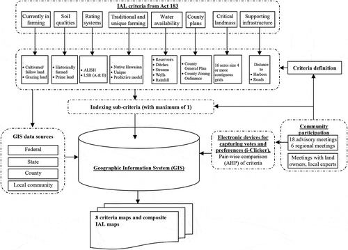
Defining and weighing criteria was a critical activity for this project. The legislative criteria were not specific enough to determine which parcels should receive IAL designation. This process was used to evaluate agricultural parcels based on how well the parcel met the requirements of the legislative criteria and which of the criteria and sub-criteria were considered most important on Kauai.
The sub-criteria indices were compared among sub-criteria with a maximum value of 1. This was done through a structured survey of stakeholder advisory committee members. Each sub-criterion was analyzed and mapped using GIS. Maps of each sub-criterion were generated and were presented to the stakeholder advisory committee and the open community meetings for review and improvement. Local agricultural experts were interviewed and consulted to calculate crop and animal productivity levels. Those data were integrated and mapped using GIS for each criterion. A linear combination method (Basnet et al., Citation2001; Bojórquez-Tapia, Diaz-Mondragon, & Ezcurra, Citation2001; Duke & Aull-Hyde, Citation2002; Eastman, Citation1995; Thapa & Murayama, Citation2008) was used to combine spatial data for each criterion to calculate an aggregate score for each parcel based on the eight criteria. The higher the score, the greater the suitability, based on the criteria and sub-criteria for designation of the parcel as IAL. The following equation illustrates how the scores for IAL were derived:
where S is the IAL score, I is the sub-criteria index (0–1), and W is the weight for criteria from AHP (1.8–10).
Spatial data were collected from secondary sources and mapped with GIS for all criteria and sub-criteria. These maps were presented in regular monthly meetings. After data and maps were presented, the stakeholder advisory committee adjusted some of the sub-criteria rankings.
Results and discussion
The stakeholder advisory committee and members of the public worked in groups to develop definitions for each criterion, considering the legislative mandates and how best to operationalize the criteria. Digital map layers for soil, streams, roads, zoning, etc., and maps showing water infrastructure of sugar plantation fields and reports of historic agricultural areas, were presented to the stakeholder advisory committee for discussion and deliberation. Definitions and maps were refined as the process continued. The stakeholder advisory committee approved the final scores after many rounds of defining, ranking, and evaluating IAL criteria ().
Table 1. Evaluation of criteria and sub-criteria by the advisory committee.
provides details on the criteria weights and sub-criteria indices. Each criterion and its sub-criteria were ranked and weighed differently by stakeholder advisory committee members and the broader community. Availability of water (Criterion 5) was ranked highest as it was identified as a major determinant of agricultural productivity. The stakeholder advisory committee, curiously, felt that consistency with county plans (Criterion 6) was least important for IAL (). Further definitions and their rankings are presented below.
Criterion 1: currently in farming
This criterion includes the lands that were actively farmed in 2010 and 2011 (most recent data available). Through an iterative process with the stakeholder advisory committee and community, three sub-criteria were identified: (1) lands currently cultivated/fallow, (2) ranching/grazing, and (3) idle. Cultivated lands were defined as those that are being currently used for agricultural production. Fallow lands were defined as intentionally left fallow to improve soil quality. Ranching/Grazing lands are those that are presently used for livestock farming. Idle lands are those that are not being used for farming despite their zoning as agricultural lands. The map of all four categories is shown in . Stakeholder advisory committee members placed the highest value on currently cultivated land by scoring this 1 out of 1 for the sub-criteria index, Ranching/grazing lands were indexed 0.78 out of 1, and idle lands were assigned a 0 value. They identified 24 types of current agricultural practices in areas that are currently in cultivation. Information provided by stakeholder advisory committee members was verified in three regional meetings and in meetings with the US Department of Agriculture (USDA), Kauai Farm Service Agency. The stakeholder advisory committee weighted it 5.4 out of a maximum of 10 for this criteria.
Figure 5. Criterion 1 map showing agricultural lands currently in farming.
Criterion 2: soil qualities
Historically, most agricultural lands on Kauai were used for sugar farming. Stakeholder advisory committee members assumed that if the land was farmed historically or if they are prime farmlands in ALISH, they would have high soil quality. Stakeholder advisory committee members identified soil of both these land types as high-quality soil for farming on Kauai based on experience farming in these areas. The stakeholder advisory committee weighed this criterion 6.3 and provided a sub-criteria index of 1 for both historically farmed lands and prime agricultural lands.
Criterion 3: rating systems
Criterion 3 refers to rating systems for agricultural lands. Among the rating systems, the stakeholder advisory committee decided to use ALISH and LSB classifications as appropriate for IAL determination. ALISH has three categories including prime, unique, and other. Prime agricultural land is best suited for the production of food, feed, forage, and fiber crops (State Department of Agriculture, Citation1977). Unique agricultural land is land other than prime agricultural land and is used for the production of specific high-value food crops such as coffee, taro, rice, and pineapple (State Department of Agriculture, Citation1977). Other ALISH is land other than prime or unique agricultural land that is of state-wide or local importance for the production of food, feed, fiber and forage crops (State Department of Agriculture, Citation1977). The LSB study is another rating system of agricultural lands that classifies agricultural lands from A to E, where A represents the highest quality agricultural land. The classification is based on soil structure, topography, climate, and rain (Land Study Bureau, Citation1967). The mapping of this criteria included A and B categories of LSB and all categories (prime, unique, and others) of ALISH ratings. This criterion was scored 5.9 out of 10.
Criterion 4: traditional and unique farming
This criterion overlaps with criterion 1. It is related to cultivation practices. Three sub-criteria were identified as (1) currently farmed areas with taro and sweet potato, (2) unique crops, and (3) areas that had taro farming in the past. This criterion was weighted 3.7 out of 10. Advisory committee members agreed that any land traditionally used for farming should be included in this criterion. In order to address this, the team used the model of historic taro farming of Ladefoged et al. Based on soil texture, water availability, and slope, taro farming locations were predicted for Kauai (Ladefoged et al., Citation2009). Unique crops included algae, aquaculture, bee farming, coffee, corn, flowers, hog, nursery, poultry, vegetables, and coconuts. Among the three sub-criteria, land with current taro farming was indexed 1, the predictive model result of taro farming was indexed 0.55, and unique crops were indexed as 0.53 out of 1.
Criterion 5: water availability
Stakeholder advisory committee members identified five sources of water: reservoirs, ditches, rainfall, streams, and wells. These sources are not mutually exclusive. The condition of water sources was assessed through research, group discussions, and mapping exercises. Only functional water sources were included in the analysis. The irrigation area for ditches, reservoirs, and streams was calculated using a gravity flow model. Rainfall of 80 in and above was determined by the advisory committee as the amount of rainfall sufficient for seasonal farming. Information about the condition of wells, reservoirs, and ditches from the stakeholder advisory committee was verified with owners and users. This criterion was ranked the highest (criteria weight 10 out of 10) because the committee believed that water availability is the most important determinant of agriculture. Combinations of water sources were identified based on practice and sub-criteria indices were created based on these combinations. Reservoir and ditches were identified as the most reliable sources of irrigation and had the highest sub-criteria value (1 out of 1). The second most important combination of irrigation sources was determined to be streams, wells, and rainfall which was indexed 0.74 out of a maximum of 1. The least important source of water for agriculture turned was wells which was valued at 0.34 out of 1.
Criterion 6: county plans
Criterion 6 is consistency with county zoning ordinance and general plans. This criterion was evaluated lowest by the advisory committee. Members provided a weight of only 1.8 out of 10 for this criterion. The sub-criterion was consistency with county zoning ordinance and the county general plan. If the agricultural land is consistent with the zoning ordinance and the county general plan, it was valued at 1 otherwise at 0.
Criterion 7: critical landmass
The score for the ‘Large or Contiguous’ criterion was calculated based on the size of land areas currently farmed, including Native Hawaiian and unique agricultural activities. Using a grid-based mapping procedure, where cells with more than 50% of an area in agricultural lands were included in the calculation of critical mass. When 4 or more 16-ac grid cells are found to be adjoining in a square, linear, ‘T,’ or ‘L’ shapes, they were considered critical landmass for agriculture. This criterion was weighted 3.3 out of 10.
Criterion 8: supporting infrastructure
This criterion is proximity of agricultural lands to supporting infrastructure. The stakeholder advisory committee identified roads and harbors as the major supporting infrastructure for agriculture. Parcels near roadways have access to supporting infrastructure including processing facilities and waste disposal sites. Parcels closer to ports lower costs for transport of goods to market. Stakeholder advisory committee members noted that most areas were accessible by roads and focused on distance calculations. Agricultural lands closer to harbors were weighted higher. Six combinations of distance from harbor and roads were identified as sub-criteria. They were weighted differently based on distance. This criterion was weighted 3.9 out of maximum 10. Regarding sub-criteria, the agricultural lands that are within a quarter mile from a road and 5 mi from a harbor were indexed 1 out of 1.
After defining, scoring (criteria weight multiplied by sub-criteria index), and mapping each criterion and sub-criteria, the scores of each parcel were mapped using GIS. The total score for each parcel ranged from 1.8 to 40 using where low scores indicate less suitability and high values indicate higher suitability. A score of 1.8 indicated land that met only one of the eight criteria, while those scores of 40 indicated that all eight IAL criteria and sub-criteria were met. The distribution of scores for all agricultural lands is contained in .
Figure 6. Threshold graph acres of agricultural land versus IAL score.
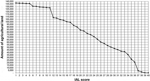
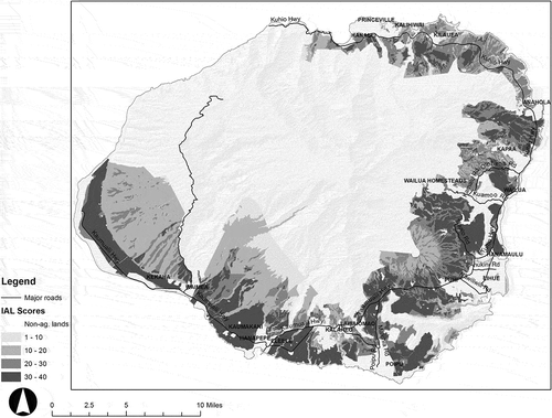
Scores range from 0 (does not meet any criteria) to 40 (meets all criteria at 100%). Note that all 136,908 ac of agricultural land scored at least 1.8, while none of the agricultural lands scored the highest score of 40. The higher the score, the more criteria were met, therefore the more stringent the requirements for being selected as ‘IAL.’ Correspondingly, the higher the score, the less land would be protected under the IAL legislation. The spatial distribution of land under different thresholds is shown in . The distribution was used to set a cutoff or threshold value for the determination of IALs. Those scoring above this value would be recommended, while those below it would not be considered for IAL.
Figure 7. Composite IAL map.
Once the criteria and sub-criteria were defined, weighted, indexed, and mapped and all agricultural parcels were scored, the next step in the process was to determine where on the 1.8–40 scoring range would the threshold for IAL be drawn. In other words, how high would a parcel need to rank to be designated IAL? The study team took several approaches to come to a consensus about determining the cutoff for IAL designation. A number of tools were developed, including a threshold graph, a slider animated tool, a scoring calculator, and a food self-sufficiency tool. These tools were uploaded on a website designed by the research team so that the broader community can view and download them on their own computer and other portable devices (https://sites.google.com/site/kauaiial/).
The threshold graph is presented in . This provides a picture of agricultural lands available to each threshold and how the amount of agricultural lands changes as the threshold increases or decreases. Different maps were produced to show the spatial representation of each threshold and respective acreage. This allowed the stakeholder advisory committee and broader community of Kauai to see the distribution pattern of agricultural lands under each threshold. This helped the community to triangulate the results of the process and actual agricultural practices on the ground.
An animated ‘slider’ movie was produced by using threshold maps and was then presented to the advisory committee. The slider is a spatial representation of the amount of land in each threshold. This is an animated form of all combinations of thresholds and respective acreages. More than 40 maps were generated presenting each threshold point and acreage. The advisory committee could select a threshold and can then view the respective map of that threshold using the slider. It gave a picture of the area that will be designated as IAL under a specific threshold.
The third tool was the spreadsheet-based scoring calculator. This tool gave the community an opportunity to identify the IAL score for individual parcels. Owners can use the 9-digit Tax Map Key (TMK) number of the parcel and get a breakdown of how their parcel scored against the eight IAL criteria. This can help the advisory committee and broader agricultural community assess how their individual parcel measures up against the IAL designation. This also helped verify the result of the model with the real situation on the ground. In monthly meetings, a personal computer was set up in the meeting room so that community member could type the TMK number of his or her parcel and get the status in terms of the eight IAL criteria and composite score.
Another analysis focused on the food self-sufficiency as discussed in Kim, Burnett, and Ghimire (Citation2015). This analysis was crucial for the stakeholder advisory committee and community to plan and decide how much land they want to preserve as IAL. The food self-sufficiency analysis was conducted using a local diet meeting USDA dietary requirements. The amount of each food item was transformed into the land requirement needed to produce it. That gave a rough idea of how much land is required for the island of Kauai to be food self-sufficient. These tools provided communities with a variety of contexts for understanding the implications of certain IAL scores for agriculture on Kauai.
The completion of IAL criteria definition and scoring presented an overall picture of criteria attainment for candidate agricultural lands. It was not enough for the community to decide how much land to be set aside as IAL for Kauai. The community required alternative scenarios to make the decision on the appropriate amount of land. Tools presented to the community facilitated decisions regarding the quantity of agricultural land to designate. Each tool gave them a unique lens through which to evaluate how much land to set aside for IAL.
Conclusions
Fast-feedback technologies and GIS can help planners and their communities in generating useful, timely input and identifying alternatives to support making better decisions. The technology not only improves the quality of discussion and deliberations but also provides more reliable, accurate, and readily quantifiable scores. This helps to increase confidence in the planning processes. It generates quantitative data on which to base decisions. The approach described in this paper was used to identify parcels to be designated as ‘IALs’ and evaluate proposals for changes in land use. The tools support other planning, zoning, and land management activities such as permitting development in sensitive areas or managing growth. The methods described can be readily adapted for evaluation of plans for new subdivisions or other projects which require changes in zoning and land use. The methods and tools are transferrable and can be used to support planning and analysis of land-use changes or as a way of capturing more meaningful input from the community regarding growth, development, and change. These methods allow for the integration of diverse data elements. The creation of an overall score with weighted subcomponents provides a straightforward, comprehensible approach considering many different factors related to agricultural land quality. The methods described allow for the consideration of the values, preferences, and concerns of different stakeholders. It also provided a systematic approach to balancing state legislative requirements with local interest and concerns. Legislative mandates require not just interpretation but also operationalization in a clear reproducible manner. The tools helped document not just the areas of agreement and disagreement over specific policy choices but also the learning and knowledge gained over the planning process. While it can be quite challenging to accommodate different political perspectives, the tools presented in this paper helped to build trust between diverse stakeholders. While this study focused on a small rural community in Hawaii, the tools and approaches are appropriate for other communities interested in integrating community input in land use planning and decision-making.
Acknowledgments
We are thankful to County of Kauai Planning Department, Stakeholder Technical Advisory Committee, Kauai Farm Service Agency, University of Hawaii Cooperative Extension Service Kauai Extension Office, Peter Nakamura, Nadine Nakamura, Made I. Brunner, Leanora Kaiaokamalie, Micahel Dahilig, Ian Jung, Ian Costa, Matthew Stevenson, Robert Ishikawa, Lauren Armstrong, and the Kauai community for their support to complete this project.
Disclosure statement
No potential conflict of interest was reported by the authors.
Additional information
Funding
References
- AbdelRahman, M.A.E., Natarajan, A., & Hegde, R. (2016). Assessment of land suitability and capability by integrating remote sensing and GIS for agriculture in Chamarajanagar district, Karnataka, India. The Egyptian Journal of Remote Sensing and Space Science, 19(1), 125–141. doi:10.1016/j.ejrs.2016.02.001
- Akıncı, H., Özalp, A.Y., & Turgut, B. (2013). Agricultural land use suitability analysis using GIS and AHP technique. Computers and Electronics in Agriculture, 97, 71–82. doi:10.1016/j.compag.2013.07.006
- Androkovich, R.A. (2013). British Columbia’s agricultural land reserve: Economic, legal and political issues. Land Use Policy, 30(1), 365–372. doi:10.1016/j.landusepol.2012.03.026
- Arciniegas, G., & Janssen, R. (2009). Using a touch table to support participatory land use planning. In 18th World IMACS Congress and MODSIM09 International Congress on Modelling and Simulation. Modelling and Simulation (pp. 13–17). Cairns:Citeseer.
- Basnet, B.B., Apan, A.A., & Raine, S.R. (2001). Selecting suitable sites for animal waste application using a raster GIS. Environmental Management, 28(4), 519–531. doi:10.1007/s002670010241
- Bengston, D.N., Fletcher, J.O., & Nelson, K.C. (2004). Public policies for managing urban growth and protecting open space: Policy instruments and lessons learned in the United States. Landscape and Urban Planning, 69(2–3), 271–286. doi:10.1016/j.landurbplan.2003.08.007
- Bojórquez-Tapia, L.A., Diaz-Mondragon, S., & Ezcurra, E. (2001). GIS-based approach for participatory decision making and land suitability assessment. International Journal of Geographical Information Science, 15(2), 129–151. doi:10.1080/13658810010005534
- Chandio, I.A., Matori, A.-N., Lawal, D.U., & Sabri, S. (2011). GIS-based land suitability analysis using AHP for public parks planning in Larkana City. Modern Applied Science, 5(4), p177. doi:10.5539/mas.v5n4p177
- Chandio, I.A., Matori, A.N., Yusof, K., Talpur, M.A.H., & Aminu, M. (2014). GIS-basedland suitability analysis of sustainable hillside development. Procedia Engineering, 77, 87–94. doi:10.1016/j.proeng.2014.07.009
- Collins, M.G., Steiner, F.R., & Rushman, M.J. (2001). Land-use suitability analysis in the United States: Historical development and promising technological achievements. Environmental Management, 28(5), 611–621. doi:10.1007/s002670010247
- Curran-Cournane, F., Vaughan, M., Memon, A., & Fredrickson, C. (2014). Trade-offs between high class land and development: Recent and future pressures on Auckland’s valuable soil resources. Land Use Policy, 39, 146–154. doi:10.1016/j.landusepol.2014.02.020
- De la Rosa, D., Mayol, F., Diaz-Pereira, E., Fernandez, M., & de la Rosa, D., Jr (2004). A land evaluation decision support system (MicroLEIS DSS) for agricultural soil protection: With special reference to the Mediterranean region. Environmental Modelling & Software, 19(10), 929–942. doi:10.1016/j.envsoft.2003.10.006
- Duke, J.M., & Aull-Hyde, R. (2002). Identifying public preferences for land preservation using the analytic hierarchy process. Ecological Economics, 42(1–2), 131–145. doi:10.1016/S0921-8009(02)00053-8
- Eastman, J.R. (1995). Raster procedures for m ulti-criteria/multi-objective decisions. Photogrammetric Engineering & Remote Sensing, 61(5), 539–547.
- El Baroudy, A.A. (2016). Mapping and evaluating land suitability using a GIS-based model. CATENA, 140, 96–104. doi:10.1016/j.catena.2015.12.010
- Gosnell, H., Kline, J.D., Chrostek, G., & Duncan, J. (2010). Is Oregon’s land use planning program conserving forest and farm land? A review of the evidence. Land Use Policy, 28(1), 185–192. doi:10.1016/j.landusepol.2010.05.012
- Governor’s Office. 2003. Executive order: Agricultural land preservation policy. In C.O. Pennsylvania (Ed.), 2003–2. Harrisburg, PA: Governor’s Office.
- Hawaii State GIS Program. (2014). Important agricultural lands. Retrieved from http://files.hawaii.gov/dbedt/op/gis/data/ial_meta.pdf
- Jankowski, P. (2009). Towards participatory geographic information systems for community-based environmental decision making. Journal of Environmental Management, 90(6), 1966–1971. doi:10.1016/j.jenvman.2007.08.028
- Janssen, R., van Herwijnen, M., Stewart, T.J., & Aerts, J. (2008). Multiobjective decision support for land-use planning. Environment and Planning. B, Planning & Design, 35(4), 740. doi:10.1068/b33071
- Jiang, L., Deng, X., & Seto, K.C. (2013). The impact of urban expansion on agricultural land use intensity in China. Land Use Policy, 35, 33–39. doi:10.1016/j.landusepol.2013.04.011
- Kalogirou, S. (2002). Expert systems and GIS: An application of land suitability evaluation. Computers, Environment and Urban Systems, 26(2–3), 89–112. doi:10.1016/S0198-9715(01)00031-X
- Keske, C., & Smutko, S. (2010). Consulting communities: Using audience response system (ARS) technology to assess community preferences for sustainable recreation and tourism development. Journal of Sustainable Tourism, 18(8), 951–970. doi:10.1080/09669582.2010.484493
- Kim, K., Burnett, K., & Ghimire, J. (2015). Assessing the potential for food and energy self-sufficiency on the island of Kauai, Hawaii. Food Policy, 54, 44–51. doi:10.1016/j.foodpol.2015.04.009
- Kuminoff, N.V., Sokolow, A.D., & Sumner, D.A. (2001). Farmland conversion: Perceptions and realities. Davis, CA: U. o. C. Davis. Retrieved from AIC Issues Brief.
- Ladefoged, T.N., Kirch, P.V., Gon Iii, S.M., Chadwick, O.A., Hartshorn, A.S., & Vitousek, P.M. (2009). Opportunities and constraints for intensive agriculture in the Hawaiian archipelago prior to European contact. Journal of Archaeological Science, 36(10), 2374–2383. doi:10.1016/j.jas.2009.06.030
- Land Study Bureau. (1967). Detailed land classification: Island of Kauai. Hawaii: U. o. Hawaii.
- Lichtenberg, E., & Ding, C. (2008). Assessing farmland protection policy in China. Land Use Policy, 25(1), 59–68. doi:10.1016/j.landusepol.2006.01.005
- Maruani, T., & Amit-Cohen, I. (2010). Patterns of development and conservation in agricultural lands—The case of the Tel Aviv metropolitan region 1990–2000. Land Use Policy, 27(2), 671–679. doi:10.1016/j.landusepol.2009.09.001
- Maryland Agricultural Land Preservation Foundation. (2013). Annual report. Annapolis, MD: M. D. o. Agriculture.
- Matthies, M., Giupponi, C., & Ostendorf, B. (2007). Environmental decision support systems: Current issues, methods and tools. Environmental Modelling & Software, 22(2), 123–127. doi:10.1016/j.envsoft.2005.09.005
- Mazzocchi, C., Sali, G., & Corsi, S. (2013). Land use conversion in metropolitan areas and the permanence of agriculture: Sensitivity Index of Agricultural Land (SIAL), a tool for territorial analysis. Land Use Policy, 35, 155–162. doi:10.1016/j.landusepol.2013.05.019
- McCown, R. (2002). Locating agricultural decision support systems in the troubled past and socio-technical complexity of ‘models for management’. Agricultural Systems, 74(1), 11–25. doi:10.1016/S0308-521X(02)00020-3
- Mendas, A., & Delali, A. (2012). Integration of multicriteria decision analysis in GIS to develop land suitability for agriculture: Application to durum wheat cultivation in the region of Mleta in Algeria. Computers and Electronics in Agriculture, 83, 117–126. doi:10.1016/j.compag.2012.02.003
- Miller, M., & Hartung, S.Q. (2012). Evidence-based clicker use: Audience response systems for rehabilitation nurses. Rehabilitation Nursing, 37(3), 151–159. doi:10.1002/RNJ.00041
- Mokarram, M., & Aminzadeh, F. (2009). GIS-based multicriteria land suitability evaluation using ordered weight averaging with fuzzy quantifier: A case study in Shavur Plain, Iran. The International Archives of the Photogrammetry, Remote Sensing and Spatial Information Sciences, 38(Part II), pp. 508-512.
- Niroula, G.S., & Thapa, G.B. (2005). Impacts and causes of land fragmentation, and lessons learned from land consolidation in South Asia. Land Use Policy, 22(4), 358–372. doi:10.1016/j.landusepol.2004.10.001
- Oregon State Legislature. (2013). Oregon revised statute (Chapter 215 - County Planning, Zoning, Housing Codes) 215 (Vols. 215.203, 215.243, 215.253, and 215.700). Salem, OR: Oregon Legislature.
- Partoyo, P. & Shrestha, R.P. (2013). Monitoring farmland loss and projecting the future land use of an urbanized watershed in Yogyakarta, Indonesia. Journal of Land Use Science, 8(1), 59–84. doi:10.1080/1747423X.2011.620993
- Pham, V.C., Pham, -T.-T.-H., Tong, T.H.A., Nguyen, T.T.H., & Pham, N.H. (2015). The conversion of agricultural land in the peri-urban areas of Hanoi (Vietnam): Patterns in space and time. Journal of Land Use Science, 10(2), 224–242. doi:10.1080/1747423X.2014.884643
- Rashford, B.S., Weber, B.A., Lewis, D.J., & Evonuk, R.M. (2003). Farm neighbors, land use policy and farmland conversion: A Dynamic simulation of land use change in Polk County, Oregon. Corvallis, OR: D. o. A. a. R. Economics.
- Romano, G., Dal Sasso, P., Trisorio Liuzzi, G., & Gentile, F. (2015). Multi-criteria decision analysis for land suitability mapping in a rural area of Southern Italy. Land Use Policy, 48, 131–143. doi:10.1016/j.landusepol.2015.05.013
- Saaty, T.L. (1980). The analytic hierarchy process. New York, NY: McGraw-Hill.
- Saaty, T.L. (1982). Decision making for leaders: The analytic hierarchy process for decision in a complex world. Belmont, CA: Lifetime Learning Publication.
- Shalaby, A.A., Ali, R.R., & Gad, A. (2012). Urban sprawl impact assessment on the agricultural land in Egypt using remote sensing and GIS: A case study, Qalubiya Governorate. Journal of Land Use Science, 7(3), 261–273. doi:10.1080/1747423X.2011.562928
- State Department of Agriculture. (1977). Agricultural lands of importance to the state of Hawaii revised. Hawaii: S. D. o. Agriculture.
- Strager, M.P., & Rosenberger, R.S. (2006). Incorporating stakeholder preferences for land conservation: Weights and measures in spatial MCA. Ecological Economics, 58(1), 79–92. doi:10.1016/j.ecolecon.2005.05.024
- Swetnam, R.D., Fisher, B., Mbilinyi, B.P., Munishi, P.K.T., Willcock, S., Ricketts, T., … Lewis, S.L. (2011). Mapping socio-economic scenarios of land cover change: A GIS method to enable ecosystem service modelling. Journal of Environmental Management, 92(3), 563–574. doi:10.1016/j.jenvman.2010.09.007
- Thapa, R.B., & Murayama, Y. (2008). Land evaluation for peri-urban agriculture using analytical hierarchical process and geographic information system techniques: A case study of Hanoi. Land Use Policy, 25(2), 225–239. doi:10.1016/j.landusepol.2007.06.004
- Theobald, D., Hobbs, N.T., Bearly, T., Zack, J., Shenk, T., & Riebsame, W. (2000). Incorporating biological information in local land-use decision making: Designing a system for conservation planning. Landscape Ecology, 15(1), 35–45. doi:10.1023/a:1008165311026
- Vaidya, O.S., & Kumar, S. (2006). Analytic hierarchy process: An overview of applications. European Journal of Operational Research, 169(1), 1–29. doi:10.1016/j.ejor.2004.04.028
- Widiatmaka, W., Ambarwulan, W., & Sudarsono, S. (2016). Spatial multi-criteria decision making for delineating agricultural land in Jakarta metropolitan area’s Hinterland: Case study of bogor regency, West Java. Agrivita, 38(2), 105.
- Zolekar, R.B., & Bhagat, V.S. (2015). Multi-criteria land suitability analysis for agriculture in hilly zone: Remote sensing and GIS approach. Computers and Electronics in Agriculture, 118, 300–321. doi:10.1016/j.compag.2015.09.016