
ABSTRACT
Old cadastral maps represent a historical reference dataset for long-term land-use reconstructions. This study presents identification of inconsistencies in the nineteenth century Franziscean cadastre, one of the largest sets of old cadastral maps worldwide, by comparing three versions of the maps and written documents created in the same period. We identified all parcels and their land-use in the four sub-sources in six study areas. The overall share of inconsistencies among 5 771 identified parcels is 7.4%, with the biggest share of inconsistency in agroforestry and forestry classes. The most frequent inconsistencies are of ‘Not differentiable land use’ (n = 212) and ‘Different land-use’ categories across the sub-sources (n = 113). We conclude that the frequency of uncertainties in old cadastral maps may limit the validity of historical land-use reconstructions, affecting the eventual restoration and management efforts based on such data. We provide a summary for the use of Franziscean cadastre.
1. Introduction
Human activity significantly alters natural systems. In recent decades the extent of such alternations was increasingly manifested by urbanisation and agricultural expansion (Science for Environment Policy, Citation2016; Song et al., Citation2018). Such interventions proved to have a significant impact, among others, on the loss of biodiversity, changes in energy fluxes, or soil degradation (Arneth et al., Citation2017; Foley, Citation2005). While current land-cover dynamics are mostly analysed by remote sensing methods (Gerard et al., Citation2010), understanding the long-term trajectory and nature of these changes must rely on accurate data about historical land-use. Such information is fundamental for applications ranging from landscape restoration to habitat conservation and is derivable from methods used in historical ecology (e.g., pollen records or tree-ring analysis; Röpke et al., Citation2011), archaeological evidence (e.g., historical demography; Klein Goldewijk & Verburg, Citation2013) or by use of archive data, mainly old cartographic sources, carrying information on land-use (Fuchs et al., Citation2015).
Old maps represent a vital source of information for land-use reconstruction, because of their spatial resolution to the level of individual plots or patches with difference in land-use. Historical spatial data is used widely to trace the impact of human activity on long-term land-use development changes across regions (Fuchs et al., Citation2015) and for land management applications, to identify valuable features for landscape planning (Skaloš & Kašparová, Citation2012), study habitat continuity important for conservation (Vojta & Drhovská, Citation2012), analyse forest extent and structure (Kaim et al., Citation2016; Müllerová et al., Citation2014), monitor loss of trees outside the forest (Plieninger, Citation2012), evaluate morphological and vegetational variations of land for landscape planning interventions (Tortora et al., Citation2015) or to study land-use conversion and its driving forces as to understand either the negative processes of land abandonment (Kanianska et al., Citation2014) or landscape fragmentation (Dewan et al., Citation2012).
Along with cartographic sources, additional information about attributes (land tenure, taxation) of a parcel is essential as it allows for a deeper insight into the societal relation to landscape. As for its sustainability analysis, they also allow us to explore past modes of agriculture (Krausmann, Citation2004) or parcel fragmentation (Sklenička et al., Citation2017). Such additional information is provided by the old cadastral apparatus, which includes numerical data for tax purposes, ownership and additional information made during the mapping campaign. Most studies have utilized only maps, while leaving the additional information behind, until now.
The use of old cadastral sources, while increasing among scholars from various disciplines, raises the question of the sources’ limitations. Uncertainties resulting from these limitations are often admitted but less frequently addressed during the data analysis. Also, these uncertainties are documented insufficiently by empirical research. The sources of uncertainty (Forejt et al., Citation2018; Leyk et al., Citation2005; Yang et al., Citation2014) originated in (i) temporal limitation also known as lack of diachronic depth – sources are referring to a single time point in the past, which contrasts the dynamically evolving landscape; (ii) deliberate distortion of information/localization, e.g., for military purposes; (iii) technical errors during the original survey (e.g., by technological limits or misunderstanding of mapping criteria by individual surveyors), or the consecutive digitalization and transformation/reprojection; (iv) semantic constraints−different meaning of land-use classes in different cartographic works; and (v) parcel boundary distortion by combining the information about land tenure and a specific land-use class. These uncertainties may fundamentally infringe upon the measures and interventions designed with the use of historical land-use reconstructions. Deriving a more accurate idea on the possible extent of these uncertainties has faced the lack of cross-comparative data.
In this respect, the Franziscean (also referred to as Stable) Cadastre is a representative example of the information-rich old cadastral apparatus that stands as a source of major importance for land-use change research in Central Europe. The cadastre was produced in the 19th century and intended to cover the whole former Austrian Empire (Feucht, Citation2008). Due to its indisputably wide spatial extent and variety of spatial and non-spatial information, this particular data source attracts increasing attention for a variety of purposes ranging from the research of land-use change on landscape-level through the reconstruction of river channels or slope movements and loss or persistency of particular land-use classes to localization of abandoned settlements and mining sites (Dolejš & Forejt, Citation2019).
To contribute the current understanding to the nature of uncertainties in old cadastral maps and extend the empirical base for uncertainties assessments, in this paper, we focus our attention on the possible limitations of the land-use attribute as recorded in four different sub-sources of the Franziscean Cadastre and its cadastral maps. For the first time, we scrutinize a larger sample of all four major cadastral sub-sources looking for the possible inconsistencies in content (land-use) and geometry (spatial boundaries) of parcels. Results are used to discuss the extent and possible effects of these inconsistencies on land-use reconstructions.
2. Materials and methods
2.1. Study area
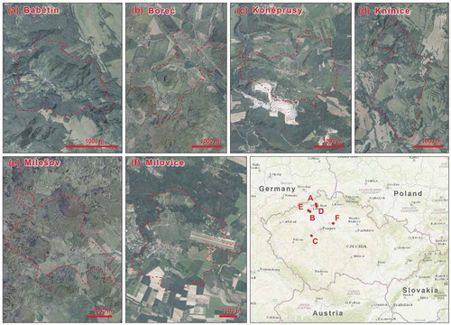
The research was conducted on six cadastral areas in Northern and Central Czechia spanning 35.1 km2, ranging from 1.9 to 11.8 km2 each (). The areas were selected to represent different topography (hilly and lowland landscapes), soils and agricultural economic structure. While the final case study may hardly cover the environmental and economic diversity of the historical landscape, it is finally a compromise between the representativeness of the research and feasibility of the empirical survey as the whole area of Czechia covered more than 13 000 cadastral areas (Bičík, Jeleček & Štěpánek, Citation2001). The simple characteristic of each area is in .
Table 1. General characteristics of the studied cadastral areas.
Figure 1. Location of the six studied cadastral districts in Czechia.
2.2. Data sources
We excerpted data for the analysis from the Franziscean cadastre. The Franziscean cadastre (named after the Austrian Emperor Francis I) is a land register produced for the former Austrian Empire between the year 1817 and the 1880 s (Feucht, Citation2008; Timár & Biszak, Citation2010) and covers at least partly current area of Czechia, Slovakia, Austria, Poland, Slovenia, Hungary, Ukraine, Croatia, Romania, Bosnia, and Serbia. The creation of the new cadastre was commenced in 1817 by an edict (ÖNB Citation2018) of Emperor Franz I. The cadastre was created from scratch, although there existed the previous land taxation system valid in the Austrian Empire, which was based on Josephian mapping (the 1780 s; Frajer, Citation2019) and represented the first measured cadastre in Austrian history. In the 1810 s it was easier to persuade the government to start new mapping because, at the same time, so-called 2nd military mapping (middle-scaled topographical maps) has started to be mapped in the Empire and the two projects used partly common triangulation (Bumba, Citation2007; Ebel, Citation2004).
The methodology for the cadastre mapping was first described in 1818 and was further adjusted in 1824 and 1865, while the work was still in progress. Thus the methodology, including the map legend, was not unified for the whole Empire (Krčmářová, Citation2015). The mapping was done mostly at the scale of 1:2880 (one Vienna square inch on the map was equal to one Lower Austrian acre in the field) and, in some areas in 1:720, 1:1440, or 1:5760. The minimal mapping unit was 25 square fathoms, which is equal to approximately 90 m2 (Ebel, Citation2004). The cadastre uses up to 40 land-use classes, including 10 agroforestry land-use classes (Krčmářová & Jeleček, Citation2017).
We analysed four elemental sub-sources of the Franziscean cadastre: Indication sketches, Original maps, Compulsory imperial imprints and Written registry (See for the first three).
Figure 2. Comparison of identical parcels in three cartographic sub-sources of the Franziscean cadastre. The fourth analysed sub-source (Written registry) is an alphanumerical protocol. Note: (i) letter ‘T’ in the Indication sketches indicates the difference between arable land and arable land shifting with pasture, (ii) Original maps containing changes drawn with red colour, (iii) low forest differentiable only in Indication sketches.
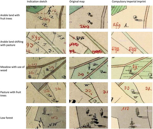
Indication sketches are a basic cartographic tool, used to record a piece of information directly in the field. It is created in colour on cardboard. Land-use, name of the owner, class of the owner, parcel number, and house number are all indicated in this document. Indication sketches were then used to mark changes in the real state in the cadastral area (Ebel, Citation2004). They were made during the summer season and used for making Original maps, Compulsory imperial imprints and the Written registry during the winter season.
Original maps are a product of office work. Made in colour on soft paper, changes from the original work were marked into Original maps in red. Original maps depict only land-use and parcel numbers, not the owner’s name.
Compulsory imperial imprints are coloured lithographic copies of Original maps of the same size. The imprints were sent to the central office in Vienna to be archived, later not used for depicting additional information, therefore they are easy to read and thus widely used (Dolejš & Forejt, Citation2019). Compulsory imperial imprints also do not contain information about the parcel’s owner.
Written registry of the Franziscean Cadastre consists of many documents for each cadastral area. We used the land parcel protocol (Grundparzellenprotocoll) because it includes clear evidence of owners as well as land-use classes and is listed according to the parcel numbers. Each row represents here a parcel and each parcel had a registered number, name of its owner, place of his residence, his ownership status, land-use of the parcel and its area. Attribute data of parcels were written down in the Written registry protocols.
2.3. Data processing
The data processing workflow is to be seen in . As reference geometry, we used Compulsory imperial imprints of the Franziscean cadastre as they provide the source with the best readability. At first, we georeferenced scanned images of all map sources in the S-JTSK coordination system with Krovak projection. Using geodatabase in ArcGIS 10.6.1 (ESRI, Citation2018), we digitized all areal objects on the map of Compulsory imperial imprints, even if it did not have a parcel number (thus not registered in the Written registry as a parcel), which rarely occurred. The exception was groups of buildings registered under one parcel number. After object topology was checked to prevent gaps and overlaps, parcel numbers were assigned to all the parcels and their sequence was checked again.
Figure 3. Data procession workflow.
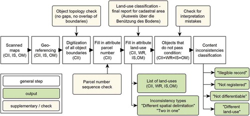
The list of land-uses in the document was used as a land-use classification. The list called Ausweis über die Benutzung des Bodens is available for every cadastral area and contains cells for 40 land-uses. There were 27 land-use classes mapped within the six studied cadastral areas (). Unlike the Franziscean cadastre, we did not differentiate between burnable (usually wooden) and not burnable (usually brick or stone) houses in our analysis, because one parcel number often contains more than one building which is spatially indistinguishable in the Written registry. For each object in the created geodatabase attributes of land-uses as depicted in Compulsory imperial imprints, Original maps, Indication sketches and the Written registry were assigned. We determined the land-use only if explicitly marked with a symbol on the map. Object’s land-use is thus not presumed according to surrounding objects. If the object had signs of two or more land-uses, all possible land-use classes were registered. We further visually detected the differences in objects’ spatial delimitation in the three cartographic sources.
Table 2. Land-use categories applied in the Franziscean cadastre.
We applied database conditions to find all objects that do not have the same registered land-use in all the four sub-sources. All objects that fulfill this condition were manually checked for interpretation mistakes to find real inconsistencies in the sub-sources. Upon the ex-ante analysis, the following types of content inconsistencies have been identified and further analysed in the whole dataset: ‘Not registered’, ‘Not differentiable’, ‘Different land-use’, and ‘Illegible record’. The inconsistencies in spatial delimitation in the three cartographic sub-sources ‘Two objects in one’, ‘Different spatial delimitation’ – were analysed visually. The Written registry was considered as a reference source for land-use as it was the basis for tax collection.
We calculated frequency, area and mean area of the inconsistencies. We explored the inconsistencies according to land-use classes and cadastral area. We analysed land-use shifts in some objects among the four data sources via alluvial plots; (Brunson, Citation2019) to show the relationship between the sources and the limitation of their use. All graphs were created in R (R Core Team, Citation2018)
3. Results
The six studied cadastral areas contained 5 771 objects, most of which were parcels with numbers. The average size of an object was 0.6 ha, with the exception in the Milovice area, in which the object size averaged 1.4 ha ().
Table 3. General characteristics of the six studied areas and their land-use structure.
In four out of six areas arable land had the biggest share (ranging from 31.3% to 66.9% among all cadastral areas), whereas forests (ranging 11.3% to 55.3% among all cadastral areas) covered over 50% of two areas – Babětín and Milešov. Meadows covered a 13.2% share of the Milovice area, and pastures in Koněprusy and Boreč covered 16.3% and 11.7%, respectively.
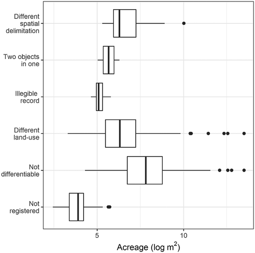
Six types of inconsistencies in content and spatial delineation of parcels in the Franziscean cadastre are shown in . There are 429 objects (in all cases parcels) with a detected inconsistency, out of which 16 objects have two inconsistencies. Meaning around 7.4% of all objects have an inconsistency which comprise 0.3% of the area. The average size of an object with inconsistency is 0.03 ha. Unsurprisingly, objects, which are ‘Not registered’, have a lesser area than objects with other types of inconsistency (), as they are too small to be registered in every data source.
Table 4. Inconsistency types in the Franziscean cadastre.
Figure 4. Inconsistency types according to object area.
There are several problematic land-uses which often include some inconsistency (high mixed forest, high coniferous forest, pasture with use of wood, vegetable horticulture, a meadow with fruit trees) or in all cases across the study area (e.g., high deciduous forest, scrub, arable land shifting with pasture, scrub and low forest) (). Land-uses containing inconsistencies in all cases indicate a systemic error. Also, certain types of inconsistencies are associated with a particular land-use, e.g., ‘Different land-use’ is typical for all sorts of pastures, while ‘Not differentiable’ are often by forest land-uses.
Figure 5. Share of inconsistencies on all parcels of a particular land-use (referential data source: Written registry).
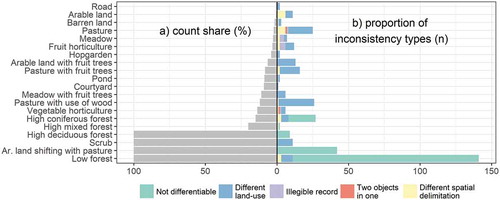
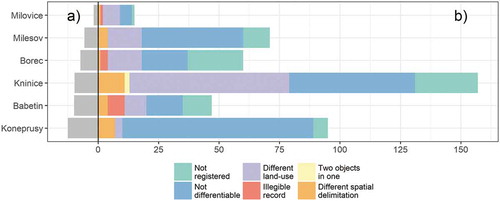
Inconsistencies are not equally distributed among the cadastral areas (). While in Milovice there are only a few objects with any inconsistency, they occur in about 10% parcels in three other areas (Babětín, Knínice, and Koněprusy). There are typical inconsistencies for some cadastral areas. Three-fourths of incorrectly registered parcels in Koněprusy are noted as ‘Not differentiable’. About 40% of wrongly assigned parcels in Knínice fall into the ‘Different land-use’ category.
Figure 6. Share of inconsistencies on all parcels in cadastral area expressed in (a) percentage and (b) count with proportion of inconsistency types (one parcel can include one or more inconsistency (parcels with more than one inconsistency = 16).
We further focus on three types of inconsistencies that cover most of the area: ‘Different land-use’, ‘Not differentiable’ and ‘Not registered’, and explore the differences in land-use of as registered across the four data sources.
3.1. Inconsistency type ‘different land-use’
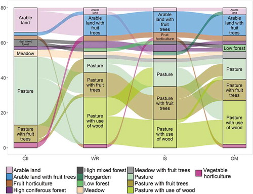
Several land-use classes tend to have ‘Different land-use’ in at least one data source (). Objects drawn as pastures in Compulsory imperial imprints are often evidenced as pastures with fruit trees or pastures with the use of wood in other sources, but there are no inconsistencies at all between the latter two. Agroforestry land-uses, e.g., pastures with any sort of wood (wood-pastures) and arable land with fruit trees are underrepresented in Compulsory imperial imprints. Pastures with the use of wood in the Written registry and Indication sketches are often registered only as pastures in Original maps.
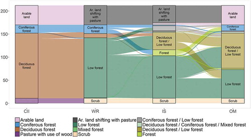
Figure 7. Shifts of land-use in inconsistency type ‘Different land-use’ among four sub-sources of the Franziscean cadastre. CII – Compulsory imperial imprints, WR – Written registry, IS – Indication sketches, OM – Original maps.
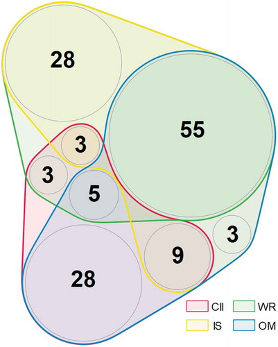
The inconsistency type ‘Different land-use’ indicates the similarity of the four data sources (). The most dissimilar are Compulsory imperial imprints with 86 objects with land-use registered differently from any other data set. Original maps have only 34 objects with uniquely registered land-use. In general, the Written registry and Indication sketches are the most similar data sets differing only in 20 cases. Original maps stand in the content similarity between Compulsory imperial imprints on one side and the Written registry with Indication sketches on the other.
Figure 8. Content dissimilarity in the four data sources. Number in the circle represents number of parcels with a specific similarity of the data sources. Note that no parcel in this case is in all four data sources because the figure is focused on the ‘Different land-use’ inconsistency.CII – Compulsory imperial imprints, WR – Written registry, IS – Indication sketches, OM – Original maps. Visualised using nVennR package (Quesada, Citation2018).
3.2. Inconsistency type ‘not differentiable‘
The inconsistency type ‘Not differentiable’ is mostly a systemic distortion within the data sets of the Franziscean cadastre and is related to two land-use classes, arable land and all types of forests. The arable land shifting with pasture is detectable in Indication sketches (mostly) and the Written registry (always) but is not differentiable from the common arable land in Compulsory imperial imprints and Original maps (). The scrub is drawn as a pasture with the use of wood in Compulsory imperial imprints unlike Indication sketches, the Written registry and Original maps. Differentiating forests in the Franziscean cadastre is a problematic task in more sub-sources. The low forests are indistinguishable in Compulsory imperial imprints. Original maps and Indication sketches often do not use enough symbols to differentiate between the forest types (e.g., abbreviation NW can stand both for Nadelwald (coniferous forest) and Niederwald (low forest); a sign of deciduous trees and bushes can mean both low forest and high deciduous forest).
Figure 9. Shifts in land-use within inconsistency type ‘Not differentiable’ among four sub-sources of the Franziscean cadastre. CII – Compulsory imperial imprints, WR – Written registry, IS – Indication sketches, OM – Original maps.
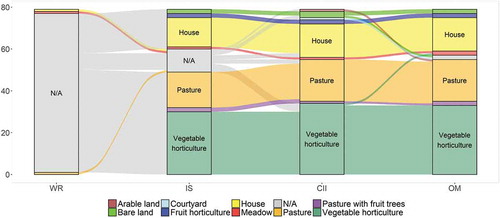
Inconsistency type ‘not registered’
Some objects are not registered in certain sub-source (). Mostly the data are not registered in the Written registry and in some cases also in Indication sketches. This occurred mostly in the case of small vegetable gardens, pastures and houses. Objects in most cases smaller than 90 m2, with no parcel number on the map and not registered as a land or construction parcel in the Written registry.
Figure 10. Shifts in land-use within inconsistency type ‘Not registered’ among four sub-sources of the Franziscean cadastre. WR – Written registry, IS – Indication sketches, CII – Compulsory imperial imprints, OM – Original maps.
4. Discussion
4.1. Extent of inconsistencies
We found four types of content and two types of object spatial delimitation inconsistencies in the Franziscean Cadastre on an example of six cadastral areas. All of the inconsistencies fall into the production-oriented inconsistencies (Leyk et al., Citation2005), or inconsistencies inherent to historical data, not connected with their digital transformation or use. The inconsistencies concern about 7.4% of all objects and 0.3% of the studied area. Krčmářová (Citation2015), who focused on agroforestry in the middle of the 19th century using the Franziscean Cadastre, compared content of the Written registry with Compulsory imperial imprints in one cadastral area. She found a 99.2% match among the agroforestry land-uses. We found 60 inconsistencies within 678 agroforestry objects in our data set (58 objects with ‘Different land-use’ inconsistency) which amounts to only 91.2% match. It is probably by the problematic determination of land-use with scattered trees present (Forejt et al., Citation2018) or the information about the presence of trees was of marginal importance to the surveyors. The presence of trees on a parcel can be a reason for authorities to award the land manager with financial support (Sandberg & Jakobsson, Citation2018). Another group of land-uses with plenty of inconsistencies is forest (only 168 consistently assigned objects out of 347 with forest land-use, i.e. 48.4%). Specifically, forest types are very often indistinguishable in particular sub-sources. This is a case for low forests in Compulsory imperial imprints. On Original maps or Indication sketches, the drawings and labels give two or more choices for interpretation of the data (vagueness according to Leyk et al. (Citation2005)) which is a cartographic deficit rather than wrongly recorded content.
Additionally, the inconsistencies do not seem to be spatially equally distributed. The survey, drawing and registering was processed in a perfect congruence in some cadastral areas (Milovice and Milešov), while other cadastral areas are very problematic (Knínice, Babětín). This may be caused by each surveyor’s precision because the survey was processed in all the cadastral areas by a different worker. Another reason could be the various levels of complexity of ownership and land-use structure or geomorphologic heterogeneity.
4.2. Pros and cons of the sub-sources for land-use reconstructions
In the following paragraphs, we summarize and discuss our main findings to provide an instructive evaluation of the sub-sources’ potential for land-use reconstructions. The summary is shown in .
Table 5. Pros and cons of the sub-sources of the Franziscean cadastre for land-use reconstruction.
First, our analysis brings to the users of Compulsory imperial imprints of Franziscean cadastre an important message. While these maps are among the most widely used data sources in landscape structure studies (Dolejš & Forejt, Citation2019) for their easy readability and accessibility, the information about three land-use types (namely arable land shifting with pastures, low forests, and scrub vegetation) is lost in the data source. Moreover, compared with reference data (Written registry), Compulsory imperial imprints display the highest differences of assigned land-use in comparison to the other map sources. This is especially obvious in the case of the agroforestry land-uses, which are massively underrepresented in Compulsory imperial imprints, although they have been used for studying agroforestry (Forejt et al., Citation2017; Vojta & Drhovská, Citation2012).
In contrast, the similarity of the Written registry and Indication sketches is high, as they were probably used to set the data into the Written registry, which was further applied for tax purposes (Ebel, Citation2004). On the other hand, the map sheets of Indication sketches must be read and interpreted carefully, as they contain markings of new objects, changes in parcels delineation, and land-use changes made after publication of the cadastre. Such informational abundance may complicate reading and result in an incorrect detection of land-uses.
Since the owners paid the taxes according to what was in the written documents and not maps, the Written registry of the Franziscean cadastre may be considered closest to the reality or at least to its representation as negotiated among stakeholders (owners, surveyors, mayors). Despite this fact, the Written registry has been scarcely used in landscape research (with exceptional studies by Szabó (Citation2010) and Krčmářová and Jeleček (Citation2017)). Work with old written sources on landscape available in archives is demanding on time and skills. If the researcher argues it not worthwhile, he must be aware of the sources’ limits.
4.3. Limits to the empirical evidence
We included in our research the inconsistencies ‘Two objects in one’ (object in one source contains two objects from the other source) and ‘Different spatial delimitation’ (object in one source has significantly different boundaries in the other source) describing mistakes in objects spatial characteristics. This was done only using visual evaluation of similarity to Compulsory imperial imprints. A more precise method would be to digitize other map sources, i.e. Original maps and Indication sketches. This task would demand specific adjustments in georeferencing for each map source and development of a computational method for assessing the rate when the delimitated parcel boundaries already significantly differ and when an object already includes two objects from the other source.
Finally, it must be reiterated that our findings are based only on six cadastral areas localized in one country of the former Austrian Empire (only in Czechia, there were more than 13 000 cadastral areas; Bičík et al., Citation2001). A different spatial setting may display other land-uses and various rates of inconsistencies. Moreover, the interpretation of the results and comparisons across the land-use categories must be made carefully as some land-use categories are only scarcely represented within the dataset. Although the sample cannot be regarded as statistically significant and the case study does not reflect the variability of natural conditions of all the regions covered by this old cadastral apparatus, the findings provide new insight in the apparatus complexity and informational quality. In particular, the found inconsistencies and their quantitative evaluation provide the empirical base for other studies exploring the possible effects of the use of old cadastral maps on the accuracy and suitability of land management interventions (e.g., land-use structure or habitat connectivity designs for restored landscapes).
5. Conclusion
The presented study analysed inconsistencies in the old cadastral sources using the example of the Franziscean cadastre from the 19th century, which covers the major part of Central Europe and is among the most frequent sources for historical land-use reconstructions. The study is based on spatial and content comparison of four sub-sources of the cadastral apparatus. According to our research, the six identified inconsistencies comprise about 7.4% of all parcels with agroforestry and forestry land-use categories being especially prone to these inconsistencies. Based on these findings we provide an instructive summary of the potential and limits of the individual sub-sources of the Franziscean cadastre for historical land-use reconstructions. While most studies in geography, landscape ecology and history generally admit uncertainties in archival sources, the present empirical evidence provides an idea of the specific uncertainties emerging from data inconsistency and their extent. To fully understand the uncertainties in land-use reconstructions resulting from data inconsistency, we call for further evidence obtained from other old cadastral sources located in other regional settings.
Acknowledgments
M.F. thanks for support of the project IGA FŽP, No. 20194230 of Czech University of Life Sciences, Faculty of Environmental Sciences. P.R. thanks for support of the project UJEP-SGS-173-07-06, ‘Environmental history of NW Bohemia’ of J. E. Purkyně University in Ústí nad Labem. Language Editing Services are acknowledged for language style revisions. Finally, we would like to thank the anonymous reviewers for their suggestions that helped to improve the early versions of the manuscript.
Disclosure statement
No potential conflict of interest was reported by the authors.
Additional information
Funding
References
- Arneth, A., Sitch, S., Pongratz, J., Stocker, B.D., Ciais, P., Poulter, B., Bayer, A.D., Bondeau, A., Calle, L., Chini, L.P., Gasser, T., Fader, M., Friedlingstein, P., Kato, E., Li, W., Lindeskog, M., Nabel, J.E.M.S., Pugh, T.A.M., Robertson, E., Yue, C., & Zaehle, S. (2017). Historical carbon dioxide emissions caused by land-use changes are possibly larger than assumed. Nature Geoscience, 10(2), 79–84. https://doi.org/10.1038/ngeo2882
- Bičík, I., Jeleček, L., & Štěpánek, V. (2001). Land-use changes and their social driving forces in Czechia in the 19th and 20th centuries. Land Use Policy, 18(1), 65–73. https://doi.org/10.1016/S0264-8377(00)00047-8
- Brunson, J.C. (2019). ggalluvial: Alluvial Plots in ‘ggplot2ʹ. R package version 0.11.1. R Foundation for Statistical Computing.
- Bumba, J. (2007). České katastry od 11. do 21. století. Grada Publishing.
- Dewan, A.M., Yamaguchi, Y., & Ziaur Rahman, M. (2012). Dynamics of land use/cover changes and the analysis of landscape fragmentation in Dhaka Metropolitan, Bangladesh. GeoJournal, 77(3), 315–330. https://doi.org/10.1007/s10708-010-9399-x
- Dolejš, M., & Forejt, M. (2019). Franziscean cadastre in landscape structure research: A systematic review. Quaestiones Geographicae, 38(1), 131–144. https://doi.org/10.2478/quageo-2019-0013
- Ebel, M. (2004). Stabilní katastr a jeho využití pro dějiny staveb (The Stable Cadastre and its use for the architecture history). In Dějiny staveb (pp. 5–13). Mikota Petr.
- ESRI. (2018). ArcGIS Desktop: Release 10.6.1. Environmental Systems Research Institute.
- Feucht, R. (2008). Flächenangaben im osterreichischen Kataster. Technische Universität Wien. ftp://ftp.geoinfo.tuwien.ac.at/other/DA_Feucht.pdf
- Foley, J.A. (2005). Global Consequences of Land Use. Science, 309(5734), 570–574. https://doi.org/10.1126/science.1111772
- Forejt, M., Dolejš, M., & Raška, P. (2018). How reliable is my historical land-use reconstruction? Assessing uncertainties in old cadastral maps. Ecological Indicators, 94(November), 237–245. https://doi.org/10.1016/j.ecolind.2018.06.053
- Forejt, M., Skalos, J., Pereponova, A., Plieninger, T., Vojta, J., & Šantrůčková, M. (2017). Changes and continuity of wood-pastures in the lowland landscape in Czechia. Applied Geography, 79(February), 235–244. https://doi.org/10.1016/j.apgeog.2016.12.016
- Frajer, J. (2019). Josefský katastr jako zdroj geografických informací o historické krajině. Geografie, 3(3), 315–339. https://doi.org/10.37040/geografie2019124030315
- Fuchs, R., Verburg, P.H., Clevers, J.G.P.W., & Herold, M. (2015). The potential of old maps and encyclopaedias for reconstructing historic European land cover/use change. Applied Geography, 59(May), 43–55. https://doi.org/10.1016/j.apgeog.2015.02.013
- Gerard, F., Petit, S., Smith, G., Thomson, A., Brown, N., Manchester, S., Wadsworth, R., Bugar, G., Halada, L., Bezák, P., Boltiziar, M., De Badts, E., Halabuk, A., Mojses, M., Petrovic, F., Gregor, M., Hazeu, G., Mücher, C.A., Wachowicz, M., Tuominen, S., … Feranec, J. (2010). Land cover change in Europe between 1950 and 2000 determined employing aerial photography. Progress in Physical Geography, 34(2), 183–205. https://doi.org/10.1177/0309133309360141
- Kaim, D., Kozak, J., Kolecka, N., Ziółkowska, E., Ostafin, K., Ostapowicz, K., Gimmi, U., Munteanu, C., & Radeloff, V.C. (2016). Broad scale forest cover reconstruction from historical topographic maps. Applied Geography, 67(February), 39–48. https://doi.org/10.1016/j.apgeog.2015.12.003
- Kanianska, R., Kizeková, M., Nováček, J., & Zeman, M. (2014). Land-use and land-cover changes in rural areas during different political systems: A case study of Slovakia from 1782 to 2006. Land Use Policy, 36(anuary), 554–566. https://doi.org/10.1016/j.landusepol.2013.09.018
- Klein Goldewijk, K., & Verburg, P.H. (2013). Uncertainties in global-scale reconstructions of historical land use: An illustration using the HYDE data set. Landscape Ecology, 28(5), 861–877. https://doi.org/10.1007/s10980-013-9877-x
- Krausmann, F. (2004). Milk, Manure, and Muscle Power. Livestock and the Transformation of Preindustrial Agriculture in Central Europe. Human Ecology, 32(6), 735–772. https://doi.org/10.1007/s10745-004-6834-y
- Krčmářová, J. (2015). Zapomínání tradičního zemědělského vědění v modernizaci: Interdisciplinární historická rekonstrukce českého lesozemědělství. Fakulta humanitních studií.
- Krčmářová, J., & Jeleček, L. (2017). Czech traditional agroforestry: Historic accounts and current status. Agroforestry Systems, 91(6), 1087–1100. https://doi.org/10.1007/s10457-016-9985-0
- Leyk, S., Boesch, R., & Weibel, R. (2005). A conceptual framework for uncertainty investigation in map-based land cover change modelling. Transactions in GIS, 9(3), 291–322. https://doi.org/10.1111/j.1467-9671.2005.00220.x
- Müllerová, J., Szabó, P., & Hédl, R. (2014). The rise and fall of traditional forest management in southern Moravia: A history of the past 700 years. Forest Ecology and Management, 331(November), 104–115. https://doi.org/10.1016/j.foreco.2014.07.032
- ÖNB. (2018). Einführung eines neuen Grundsteursystems. Patent von Franz I. 27. Dezember 1817. Retrieved June 16, 2018, from http://alex.onb.ac.at/cgi-content/alex?aid=pgs&datum=1817&size=45&page=445
- Plieninger, T. (2012). Monitoring directions and rates of change in trees outside forests through multitemporal analysis of map sequences. Applied Geography, 32(2), 566–576. https://doi.org/10.1016/j.apgeog.2011.06.015
- Quesada, V. (2018). nVennR: Create n-dimensional, Quasi-Proportional venn diagrams. R package version 0.2.1. R Foundation for Statistical Computing.
- R Core Team. (2018). R: A language and environment for statistical computing. R Foundation for Statistical Computing.
- Röpke, A., Stobbe, A., Oeggl, K., Kalis, A.J., & Tinner, W. (2011). Late-Holocene land-use history and environmental changes at the high altitudes of St Antönien (Switzerland, Northern Alps): Combined evidence from pollen, soil and tree-ring analyses. The Holocene, 21(3), 485–498. https://doi.org/10.1177/0959683610385727
- Sandberg, M., & Jakobsson, S. (2018). Trees are all around us: Farmers’ management of wood pastures in the light of a controversial policy. Journal of Environmental Management, 212(April), 228–235. https://doi.org/10.1016/j.jenvman.2018.02.004
- Science for Environment Policy. (2016). No net land take by 2050 ? Produced for the European Commission DG Environment by the Science Communication Unit, UWE. https://doi.org/10.2779/537195
- Skaloš, J., & Kašparová, I. (2012). Landscape memory and landscape change in relation to mining. Ecological Engineering, 43(June), 60–69. https://doi.org/10.1016/j.ecoleng.2011.07.001
- Sklenička, P., Zouhar, J., Trpáková, I., & Vlasák, J. (2017). land use policy trends in land ownership fragmentation during the last 230 years in Czechia, and a projection of future developments. Land Use Policy, 67(February), 640–651. https://doi.org/10.1016/j.landusepol.2017.06.030
- song, X.-P., Hansen, M.C., Stehman, S.V., Potapov, P.V., Tyukavina, A., Vermote, E.F., & Townshend, J.R. (2018). Global land change from 1982 to 2016. Nature, 560(7720), 639–643. https://doi.org/10.1038/s41586-018-0411-9
- Szabó, P. (2010). Driving forces of stability and change in woodland structure: A case-study from the Czech lowlands. Forest Ecology and Management, 259(3), 650–656. https://doi.org/10.1016/j.foreco.2009.11.026
- Timár, G., & Biszak, S. (2010, February). Digitizing and georeferencing of the historical cadastral maps (1856-60) of Hungary. 5th international workshop on digital approaches in cartographic heritage. Vienna, Austria, 22–24 February 2010, 22–24.
- Tortora, A., Statuto, D., & Picuno, P. (2015). Rural landscape planning through spatial modelling and image processing of historical maps. Land Use Policy, 42(January), 71–82. https://doi.org/10.1016/j.landusepol.2014.06.027
- Vojta, J., & Drhovská, L. (2012). Are abandoned wooded pastures suitable refugia for forest species? Journal of Vegetation Science, 23(5), 880–891. https://doi.org/10.1111/j.1654-1103.2012.01399.x
- Yang, Y., Zhang, S., Yang, J., Chang, L., Bu, K., & Xing, X. (2014). A review of historical reconstruction methods of land use/land cover. Journal of Geographical Sciences, 24(4), 746–766. https://doi.org/10.1007/s11442-014-1117-z