
ABSTRACT
Human-induced activities are threatening the socio-economic and ecological sustainability of land systems globally, including in tropical, low-income regions. In these regions, land-use planning is used to assess, manage, and monitor the physical, social, and economic conditions of territories and thus assist agribusiness, smallholder farmers, and other land users. There is, however, a lack of systematic studies identifying strategic land-use planning instruments and further detailing the extent to which their characteristics support land governance. In this paper, we attempt to address this gap. Based on a literature review, we identified three clusters of instruments, supporting land-use planning: (I) land-assessment instruments, (II) land-zoning instruments, and (III) participatory instruments. Plan-implementation instruments were not found. We conclude by sketching future research on (i) land tenure–planning nexus, (ii) streamlining plan-implementation, and (iii) transdisciplinary planning processes, intended to expand further the importance of the strategic approach in land-use planning in terms of governing tropical landscapes.
Introduction
Pressure on land and other natural resources, due to human-induced activities and climate change, is dramatically increasing in many tropical, low-income regions, raising serious concerns about social, economic, and ecological sustainability (Andronache et al., Citation2019; Lambin & Meyfroidt, Citation2011; Meyfroidt, P. Lambin et al., Citation2013). The pace of change affecting the biosphere, due to land uses, such as agricultural activities and urbanization in these regions, is overwhelming (Masterson et al., Citation2019). Land-use planning, in this context, emerges as a technical-political instrument, guiding future uses of land. Its objectives are, among others, to organize a territory by arranging the representation of existing land uses through diagrams, maps, and written documents (FAO = Food and Agriculture Organization, Citation1999). Land-use planning has been used to assess the physical, socio-economic, institutional, and legal constraints for a socially defined, sustainable use of land resources, including in tropical, low-income, rural areas (Ramakrishna, Citation2003). Land-use planning in rural areas is thought to support decision-makers and land users in selecting and putting into practice those land uses that will best meet the needs of local, rural communities, while safeguarding natural resources and ecosystem services (FAO = Food and Agriculture Organization, Citation1993; Kleemann et al., Citation2017). This balance is essential for both the sustainability of present and future generations of farmers. Land-use planning aims to empower public and private actors to make strategic decisions on how to allocate land (Gerber et al., Citation2017). Land-use planning is also expected to contribute to resolve, mitigate, avoid, or forestall land-use conflicts (Boix & Zinck, Citation2008; De Jong et al., Citation2021). Land-use planning processes can contemplate environmental concerns [e.g. zoning protected areas; agro-ecological zoning, i.e. land areas defined, based on combinations of soil, landform, and climatic characteristics (FAO = Food and Agriculture Organization, Citation1996)]. Such processes can also consider how different land uses are connected. In many European countries, for example, land-use planning solidifies the extent of forest-designated lands, whether public or private, so that urban growth or agricultural expansion only have a limited impact on forested landscapes (Mather, Citation2007). Certain Austrian and German states (Bundesländer), as well as Portugal have developed a variety of land-use planning instruments for cropland protection; these include defining priority areas for agricultural activities or establishing national targets to limit land-take (Oliveira et al., Citation2019). For instance, the Portuguese National Agricultural Reserve or Reserva Agrícola Nacional ‘defines priority areas for agricultural land use to be implemented by the municipalities’ (Oliveira et al., Citation2019, p. 5).
In tropical, low-income regions, land-use planning instruments for agriculture are fundamental in supporting the social and economic conditions of local communities (FAO = Food and Agriculture Organization, Citation2017; Lambin, Gibbs, et al., Citation2013). Absent or ineffective land-use planning often results in loss of land for food provision or the livelihoods of smallholder farmers (Gasparri et al., Citation2015). Furthermore, large tracts of agricultural land or large-scale land acquisitions (LSLAs) in the tropics have been acquired by corporations from high-income countries, seeking to ensure their food supplies (Ingalls et al., Citation2018; McMichael, Citation2013). Consequently, extensive agricultural investments have been threatening rural populations and smallholder farmers, which typically produce the bulk of the food in these regions. For example, Samberg et al. (Citation2016) estimated the contribution of smallholders in an analysis of 41 crops and 83 countries in smallholder dominant regions (Latin America, sub-Saharan Africa and South and East Asia) that represent 35% of global cropland. Ramankutty et al. (Citation2018) found that farms of less than two hectares produce approximately 30% of the total crop production and approximately 34% of the food supply on 24% of the gross agricultural land, when using their measured farm size dataset. The findings of Ramankutty et al. (Citation2018) are in line with Samberg et al. (Citation2016) and Herrero’s global estimates (Herrero et al., Citation2017). The influence of private actors and forms of market-based governance strengthen, in theory, the importance of land-use planning in promoting social, economic, and ecologically sustainable land uses (Rudel & Meyfroidt, Citation2014; Meyfroidt, P. Lambin et al., Citation2013). However, land-use planning in tropical regions is often weakly designed (the designing phase of a planning process can also be defined as the plan-making phase, see Hersperger et al., Citation2019) or imperfectly implemented, thus often failing to achieve social and environmental objectives. It is thus important to better understand how land-use planning can be improved to assume a strategic importance in governing land resources in tropical regions, marked by acute land-use changes and globalized agro-food systems (Bull et al., Citation2021).
The strategic approach to spatial planning, i.e. ‘a set of governance practices for developing and implementing strategies, plans, policies and projects, and for regulating the location, timing and form of development’ (Healey, Citation1997) emerged around the 1970s, primarily among high-income countries, mainly in Western Europe and North America, with the aim of supporting the sustainable use of natural resources, such as land (Albrechts, Citation2017). Strategic spatial planning (SSP) has been conceived as a means of envisioning shared, realistic, and desirable futures for local communities (Hersperger et al., Citation2019), working as a framework of reference for strategic decisions that are simultaneously visionary and pragmatic (Kunzmann, Citation2010). While land-use plans are, by definition, legally binding for local government authorities, strategic spatial plans assume multiple legal forms (Oliveira & Hersperger, Citation2019). They can work as guidelines for spatial development as in Ireland (Daly, Citation2016), for example, or assume a binding status for local tiers of government, as for instance, in Finland (Eräranta & Mladenović, Citation2021). Kunzmann (Citation2010) argues that ‘strategic planning is more than land-use planning, more than just assigning uses to spaces (…) and waiting patiently for public and private investors to realise such assignments’ (p. 38). In practice, this means that SSP goes beyond land-use planning efforts, which are primarily focused on optimizing the productivity of the land for the development of economic activities and improving the social conditions of local communities, while protecting ecological values and biodiversity (IFAD = International Fund for Agricultural Development, Citation2014). The primary differences between land-use planning and SSP are that, on the one hand, land-use planning entails public, actor-led forms of detailed planning, combining land-use control schemes, such as land-use zoning, with the preparation and implementation of these land-use plans, often following a specific set of rules, rather inflexible to change. On the other hand, SSP intends to be a dynamic and creative process, targeting discovery and flexibility, with a long-term perspective of 20, 30 or more years in the future (Hersperger et al., Citation2019; Kalliomäki, Citation2015). In this respect, Mazza (Citation2010) underlines that it is rather challenging, and sometimes even impossible, to shift or cancel the course and consequences of a land-use planning decision. Furthermore, land-use planning essentially concerns land and how to use and reuse it; land is a limited and scarce resource (cf. Lambin & Meyfroidt, Citation2011). SSP involves a broader range of resources and activities (Albrechts, Citation2017).
Spatial planning theory often considers strategic spatial plans and land-use plans as the outcomes of separated planning processes (Albrechts, Citation2017). To date, few studies have explored the relationship between SSP and land-use planning. Some of these studies highlight the differences between them, primarily in relation to their statutory meaning, i.e. legally binding versus guidance frameworks (Searle, Citation2017) or their complementarity (Mäntysalo et al., Citation2015). Yet while both SSP and land-use planning are familiar concepts, their combination as strategic land-use planning (SLUP) is recent (Henríquez-Dole et al., Citation2018). In theory, the participatory character of land-use plans and the general aims of contributing to collective wellbeing and the protection of socio-ecological systems for current and future generations, should ensure that land-use planning can support sustainably- and strategically oriented land-use governance in tropical regions and beyond (Oliveira & Hersperger, Citation2018). These definitions, thus, highlight the conceptual and practical cross-fertilization of land-use planning and SSP (Mäntysalo et al., Citation2015). The boundaries between strategic and land-use plans are, in practice, not as fixed as theoretical conceptualizations postulate (cf. Searle, Citation2017). Both strategic plans and land-use plans support decision-making concerning spatial development, influencing one another (Faludi, Citation2000). A strategic approach to land-use planning involves, in this conceptual lens, a spatial exercise, as well as a social process of defining a vision for the future and strategies to reach that vision, that include the interests of local communities and those of private actors and land developers (Albrechts, Citation2017). Douma and colleagues also argue that strategic approaches to land-use planning facilitate a greater control over the misuse of natural resources because, among other factors, they allow for a better coordination of different land-use activities by public actors, such as governments (Douma et al., Citation1989). They also enable better coordination of the various land-use activities by governmental organizations (Henríquez-Dole et al., Citation2018).
In this paper, we specifically focus on rural areas of the tropics, to explore how a closer interrelationship between land-use planning and SSP can contribute to achieving sustainability objectives in these contexts. Lambin et al. (Citation2014), in line with Mascia et al. (Citation2014), argue that if certain land-use planning instruments, such as zoning, are not integrated into long-term planning strategies, land becomes vulnerable to private interests from agribusiness or forestry. This paper is a contribution to the broader effort of understanding SLUP as a land governance instrument in tropical and subtropical regions, from humid forests to sub-humid (or savannah) and semi-arid landscapes (Peña-Claros et al., Citation2009; Young, Citation1989). Land governance, as defined in this study, involves planning, policies, processes, and institutions by which land, property and other natural resources are managed and conflicting interests in land are settled (Osabuohien, Citation2015). The findings of this review should inform further discussions on the broader importance of spatial planning, both strategic and land-use planning in tropical regions, among others, as well as in those regions in frontier situations (Carlson et al., Citation2014) or that are considered hotspots of land use and cover change (cf. Mendoza-Ponce et al., Citation2019). Land-use frontiers are territories with copious land for agriculture and forestry, an availability of natural resources relative to labour or capital and rapid land-use change (Pacheco et al., Citation2021; Le Polain de Waroux et al., Citation2018). In this context, frontiers are characterized by the emergence or spread of land management-practices that break from the practices that were already in place, affecting the established practices of smallholder farmers, and possibly leading to friction, conflict, or land-use competition (Rindfuss et al., Citation2007).
Theoretically, we build on the literature referring to the relationship between SSP and land-use planning as ‘dualistic’, i.e. SSP and land-use planning are not mutually exclusive but potentially reinforce one other (Mäntysalo et al., Citation2015; Mazza, Citation2010). We have assigned the retrieved instruments, based on the so called SPlaMI framework, i.e. a ‘Strategic Spatial Plan-Making and Plan-Implementation’ framework, developed by Hersperger et al. (Citation2019, Figure 2, p. 99). The SPlaMI framework ‘illustrates the key components and interrelationships necessary for making and implementing a strategically oriented and realistic strategic spatial plan’ (p. 98). To the best of our knowledge, this is the latest framework which disentangles the SSP processes and results from case-study work, conducted by a multi-disciplinary team. However, as we were only able to retrieve instruments, which are primarily applied during the preparation, design, or plan-making phase, we focused solely on the first section of Hersperger et al.’s framework, i.e. the plan-making phase. Therefore, this review attempts to address the following research question: can a strategic approach to land-use planning or SLUP contribute to the improvement of land governance in tropical, low-income regions? Two interlinked operational objectives structure the paper: (i) to identify the instruments used within strategic approaches to land-use planning and how these instruments have been used, and (ii) to understand better how these instruments can contribute to improve land governance in tropical landscapes or tropical regions. The next section details the methodology, followed by a section analysing the results of the systematic literature review. The subsequent section discusses the instruments identified. The last section concludes with the prospects for expanding research with respect to the overall importance of the strategic approach to land-use planning in relation to governing land in the tropics.
Methodology
We searched for literature, published between 1950 and 2019, in both academic and grey literature, in the English language. We followed the ‘Guidelines and Standards for Evidence Synthesis in Environmental Management’ (CEE = Collaboration for Environmental Evidence, Citation2018) and conducted this review in five steps between January and August 2020. The preliminary step entailed the formulation of the research question and research objectives, as stated in the introduction.
First step – elaborating the search protocol
we delineated the scope supporting the literature search, including the spatial planning dimension, the geographical scope (i.e. tropics), and the land qualifiers (). Land qualifiers are used to capture events or situations, that constitute typical challenges involving the use of land. For example, the qualifier ‘land deal’ captures, while being brief, the issue of transnational land deals or transnational land acquisitions, i.e. land-based investments, which have been challenging land use and land users in tropical regions (see for example, Debonne et al., Citation2019 for large-scale land acquisition in Cambodia). We elaborated upon and ran various search query strings in the search databases of Google Scholar, and ScienceDirect until we found reasonable results and a final query. We also ran the final search string in the online citation database, Web of Science, however, the large number of publications retrieved, precluded the practical utilization of this database (approximately 117,000 publications).
Table 1. Literature search-terms with geographical scoping on the tropics
Second step – searching for literature
we conducted a systematic search for literature, using a repeatable search strategy, tailored to the research question and objectives. A published record was included in the results if it matched the following criteria: (i) the record dealt with strategic and land-use planning conceptually or empirically, (ii) it was published in an English-language, peer-reviewed, academic journal, as a conference proceeding, as a working paper or as an academic book or book chapter in an edited volume. After running the final search string, we obtained 792 results and 622 after deleting duplicate records. We were able to download 100% of the retrieved results as PDF files. Most of the retrieved publications, after deleting duplicate, were published in or after the year 2000 (93%). Seven percent were published between 1950 and 1999. Of the 622 retrieved publications, 34% were conceptual, 61% were empirical, containing at least one case study within tropical regions, and 5% were reports.
Third step – critical appraisal and abstract screening
we screened the abstract (or introduction if the abstract was not available) of the preliminary sample of 622 publications to assess their meaningfulness regarding the research question, thereby excluding 34 records without a clear focus on land-use planning or strategic spatial planning in predominantly tropical landscapes, or that only marginally referred to the geographical scope and land qualifiers.
Fourth and fifth steps – full article screening, content analysis and reporting
the final sample of 588 records was assessed for quality, which required in depth reading of the full text. We then carried out an analysis of this final sample before reporting the findings.
Although we analysed the entire final sample of published records (588) for readability purposes and due to length limitations in this paper, we do not refer to every record in the results. We place particular emphasis on less recent publications, i.e. those published between 1950 and 1999 as some of these are seminal works (e.g. Hyman, Citation1984) and are foundational for defining the instruments. We first report on the instruments used within SLUP and succinctly describe their objectives (). We then critically assess how these instruments have been used in the tropics. These pave the way for the discussion on how the set of instruments retrieved from the literature support land governance in tropical regions.
Table 2. Strategic land-use planning (SLUP) instruments retrieved from the literature search
Results
Strategic land-use planning instruments in tropical regions
provides a summary of the instruments identified in the literature. Based on Hersperger et al. (Citation2019), we have clustered the instruments into three clusters of instruments supporting strategic land-use planning: (Cluster-I) land-assessment instruments, (Cluster-II) land-zoning instruments and (Cluster-III) participatory instruments. Within the framework of Hersperger et al. (Citation2019), plan-making encompasses the development of visions and decision frameworks, intended to represent, govern, and influence spatial transformation (cf. Albrechts, Citation2017). Land assessment instruments reflect what Hersperger et al. (Citation2019) define as negotiation, in the sense of determining activities, i.e. land-use potential. Land-zoning instruments reflect what Hersperger et al. (Citation2019) term consolidated planning practice, i.e. the experience of dealing with SSP processes. Participatory instruments reflect what Hersperger et al. (Citation2019) regard as civic participation and the involvement of private interest groups. Our literature research did not retrieve publications explicitly discussing plan-implementation instruments.
Certain important instruments did not appear in the results from our literature search, such as the use of games or multi-stakeholder engagement. However, these are critical in supporting the land governance of tropical regions. For example, Speelman et al. (Citation2017) use gaming (also defined as ‘serious gaming’, ‘participatory gaming’ or ‘role-playing’) as a ‘participatory approach to learn about, discuss and explore the complexity’ of contested landscapes (p. 1). Serious games, including role-playing game experiments (Becu et al., Citation2017), have been used, for instance, to stimulate a change of habits and practices involving real world problems, including planning issues (Le Page et al., Citation2013). Furthermore, serious games have recently been extended to include the realm of conservation policies, as well as to support wider participation in land-use planning processes (Barreteau et al., Citation2021). In such approaches, participants, such as farmers, use games or role playing (e.g. farmers enacting negotiation processes with private interest groups) to explore behaviours, prepare strategies and ultimately contribute to overall land-use planning. J.C. Castella et al. (Citation2020), in a study intended to engage the farming communities in Laos in participatory land-use planning, employ role-playing games as participatory tools, useful ‘to collectively discuss issues and explore solutions’ and ‘to build the facilitation capacities of extension agents and turn them from lesson givers to facilitators of innovation processes’ (p. 28). Bourgoin et al. (Citation2012) combined role-playing games, participatory 3D modelling, Geographic Information Systems (GIS), and socioeconomic and environmental impact assessments to explore the consequences of land-use decisions and to further select from a range of future landscapes. They used a role-playing game to train village land management committees in the uplands of Laos ‘in negotiating land zoning on a stylized landscape’ (p. 274). J.-C. Castella et al. (Citation2005) used role-playing games in the form of a board game, composed of cubes, with each side representing a type of land use in a participatory simulation of land-use changes in the Northern mountains of Vietnam. Another important instrument is multi-stakeholder involvement (Poku-Boansi, Citation2021). Multi-stakeholder involvement is a process of collaboration, in which two or more actors work together to pursue a common goal (Azadi et al., Citation2011). Hemmati (Citation2002) defined it as a process, aimed at bringing together all major stakeholders in a new form of communication and decision-making regarding a real-life problem. In a study on land-use planning in Ghana, Poku-Boansi (Citation2021) reveals that most of the inputs into land-use planning processes were expert-driven, which ‘partly explains the high rates of non-compliance and conflicts’ and ‘promotes the misallocation of land’ (p. 10).
Cluster I: Land-assessment instruments
Agronomic potential surveys are essentially associated with determining the qualities of the soil in general, not a specific crop. These surveys classify land, for example, according to the rainfall and soil types (Hyman, Citation1984). Based on these surveys, land is classified as suitable for agriculture, grazing, forestry, recreation, conservation, or other uses (Shaxson et al., Citation1977). Agronomic potential surveys are described as instruments to develop context-specific land governance configurations, i.e. adapted to local conditions (Toolsie, Citation1967). These types of surveys have been used in the tropics to determine areas of prime inherent quality, which were to be reserved to grow annual arable cash crops. Agronomic potential surveys were adapted for many tropical regions, such as Zimbabwe (Conex, Citation1960), Malawi (Shaxson et al., Citation1977) and Zambia (ZDA = Zambia Department of Agriculture, Citation1977).
Soil potential surveys for agricultural production have been used in tropical regions, as a component of agronomic potential surveys, to evaluate, summarize and map discrete landscape segments from the best to the least suited soils for agricultural activities and forestry, based on the interacting complexes of climate, vegetation, landform, and geology (Laban, Citation1981). Hyman (Citation1984) underlined this concept even in the 1980s, as Malaysia had one of the most effective agronomic potential surveys, supported by geological surveys and regional soil potential surveys for agricultural production. Laban (Citation1981) underlines that those Southeast Asian countries differ vastly regarding land-use problems, which demand adapted approaches to forestry, agricultural development, and land-use planning. To this end, soil potential surveys for agricultural production within broader agronomic potential surveys are useful land-use planning instruments for long-term, strategic-oriented planning (cf. Van Gool et al., Citation2005).
Crop suitability surveys essentially comprises the assessment/determining of the suitability of a soil for a particular crop. This evaluation can be broadly defined as a process of identifying the spatial appropriateness for possible land uses, according to environmental conditions (Hopkins, Citation1977). Crop suitability surveys were used for land-use planning scenarios through community participation (M. J. Gwaleba & Masum, Citation2018). This is in line with Laban (Citation1981), who argued that if land, as a resource, is to respond to the needs of local communities, then land evaluation procedures could be integrated into land-use planning processes. Crop suitability surveys, with its emphasis on specifying land-utilization types, introduces a long-term dimension to land-use planning (Young, Citation1989) since it considers various limiting factors in the long-term, that are essential for specific land uses (Yu et al., Citation2018). Crop suitability surveys for a specified use is assessed by comparing the requirements of land qualities; examples are moisture availability, nutrient availability, and the potential for mechanization (Laban, Citation1981).
Scenario development, including scenario analysis (Yu et al., Citation2018) complement the above clusters and boost strategic, long-term approaches to land-use planning (Henríquez-Dole et al., Citation2018; Hoanh et al., Citation2018). For example, Henríquez-Dole et al. (Citation2018) argue that scenario analysis enables the achievement of a balance between social and ecological values, in favour of sustainable development, specifically during the designing or plan-making phase of a land-use plan. The methodology of developing scenarios is useful in assessing, among other advantageous points, ‘possible future changes in agricultural land use’ and ‘how policies may influence [future] land-use patterns’ (Piquer‐Rodríguez et al., Citation2018a, p. 1). Developing scenario analysis, which includes identifying land-use patterns, historical land-use information, and trend extrapolation of land uses, has also been employed as an instrument in more strategic-oriented, land-use planning in the tropics (e.g. Bourgoin et al., Citation2012; Chigbu et al., Citation2016). For example, Bourgoin et al. (Citation2012) provide an interesting account on the linkage between land-use scenarios and land-use, plan-making processes in Laos. Bourgoin and colleagues report that scenario development (or scenario making) exercises helped local communities explore various options for future spatial developments. These communities were able to negotiate land uses and adjust and/or readapt the plans until consensus was reached among various stakeholders (i.e. villagers, district authorities, conservationists). Developing land-use scenarios, with realistic simulations, resembled a rehearsal for land zoning negotiations, that contributed to the land-use plan. This involvement began the process of empowering local participants, who could employ the lessons learned during the simulation and demonstrate local appropriation and adoption of the process to engage more actively in the planning of their village (Bourgoin et al., Citation2012).
Cluster II: Land-zoning instruments
Land-zoning instruments are used to divide a territory into zones with different rules and regulations for land use, management practices and land cover change. The objective of zoning is to encourage the use of land within sustainability principles, by rationalizing land uses, limiting environmental degradation, and further supporting local communities to use and benefit from the land and other natural resources (Nolte et al., Citation2017). Land-use planning embeds formal procedures and regulations that govern the use of land (M.J. Gwaleba & Chigbu, Citation2020). These are composed of several regulatory and non-binding instruments, which aim to increase the efficacy and efficiency of the use of land and ensure greater equity regarding its use (Hall et al., Citation1973). Land-zoning instruments, in general, delineate areas to be designated for agriculture, (known as agro-ecological zoning), residential areas or forestry, among others (Nolte et al., Citation2017; Piquer‐Rodríguez et al., Citation2018b). In tropical regions, regulatory land-use zoning co-exists and sometimes conflicts with informal, customary land tenure regimes (Lestrelin et al., Citation2012). Regulatory land-use zoning instruments are employed in tropical regions to designate forestry areas or other types of forest conservation or protected areas, which can be effective tools in preserving forests or other natural habitats, such as in Bhutan (Bruggeman et al., Citation2018). Nolte et al. (Citation2017) found evidence that provincial-level, land-use zoning reduced deforestation in the Argentinian provinces of Salta, Santiago del Estero, and Chaco. Ebregt and De Greve (Citation2000) discuss the concept of buffer zones. Buffer zoning is often applied to simultaneously minimize human impact on conservation areas and to address the socio-economic needs and wants of the affected local communities (cf. Sayer, Citation1991). Buffer zones are seen as an important instrument in conserving areas of ecological importance, while at the same time addressing the spatial development issues of the people in the areas surrounding it. Land-use zoning can allow for multi-functional areas, such as combining nature conservation with the community-based management of natural resources, which can be very effective (Dawson et al., Citation2021). Establishing protected areas creates zones of land that are distinctly defined where only non-human species would live. Protected areas as zoning instruments also reflect a more holistic approach to conservation, linking human communities and human issues to species’ conservation and land-use management (Harrop, Citation2007). However, Busscher et al. (Citation2018)argue that protected areas have become exposed to land grabbing, i.e. the buying or leasing of large tracts of land by national and transnational corporations, governments, and individuals. For instance, the Iberá National Park is a protected area of 482,000 hectares in Argentina’s central Corrientes Province, bounded by the Paraná and Uruguay rivers. However, several socio-environmental conflicts have occurred and threats to biodiversity protection remain a reality, including the construction of illegal drainage channels, harmful practices such as the application of chemicals and fertilizers and the spread of invasive exotic plants (Busscher et al., Citation2018).
Cluster III: Participatory instruments
Participatory instruments help to shape and frame land-use plans and play an important role in land zoning (Suhardiman et al., Citation2019). Overall, instruments supporting community and/or stakeholder participation have been extensively debated in the retrieved literature (e.g. FAO = Food and Agriculture Organization, Citation1993; Henríquez-Dole et al., Citation2018). Knowledge exchange within community consultation, for instance, is primarily used to value indigenous and ancestral knowledge in long-term, land-use planning (e.g. Boutthavong et al., Citation2017; O’Sullivan & Norfolk, Citation2017). Participatory instruments have also been used to identify classes of farming systems (Wood, Citation1995). For example, the report on the technical validation and policy dialogue for the land governance assessment framework in Malawi recommended that local authorities include instruments to assure civic participation in the process of land-use planning (Jere, Citation2012). Other studies have shown the benefits of joint meetings between private interest groups and local communities (Seghezzo et al., Citation2017) in land policy and planning. This participation can benefit all the parties involved, including public or private stakeholders, as well as smallholder farmers (Ezeaku & Davidson, Citation2008). In Burkina Faso, community participation in land-use planning was presented as a mechanism, supporting community-land demarcation (Steppler & Nair, Citation1987). In Ethiopia, the federal constitution stimulates active community participation in the development of land-use policies that affect their livelihood. Suhardiman et al. (Citation2019), based on research on land-use planning in Laos, contend that ‘direct participation in land-use planning processes does not in itself guarantee the plan’s actual significance’ (p. 355). They argue that it is challenging ‘to fulfill the rationales behind the plan through its implementation if powerful groups within the local communities lack any incentive to do so in the first place’ (Suhardiman et al., Citation2019, p. 355). A study involving conflicts between various ethnic groups in Thailand, who were integrating crops into different levels in forestland, highlighted the need for intra-community negotiations in land-use planning processes (Steppler & Nair, Citation1987). Furthermore, participatory mapping has also been used as an instrument for landscape land-use planning (Bourgoin et al., Citation2012) for example, in rural Mexico (Valencia-Sandoval et al., Citation2010) or Burkina Faso (Hessel et al., Citation2009).
Discussion
Disentangling how strategic land-use planning instruments support land governance
We argued earlier in this paper that understanding how land and land-use changes are governed is essential in addressing sustainability challenges, for instance, in local, rural communities (Tellman et al., Citation2020). However, the extent to which SLUP instruments could be effective in supporting land governance in tropical regions remains understudied. This is challenging because the latest trends in land-use planning across low-income regions indicate a dynamic of strengthening local and global forces (Rudel & Meyfroidt, Citation2014). In addition, Sachs et al. (Citation2019) call for strategic land-use, ocean-use and water-based planning approaches to help manage competing claims on land and water for food production, sustainable spatial development, industry and mining, ecosystem management, carbon sequestration and biodiversity conservation (cf. Schmidt-Traub et al., Citation2019). Based on the previous sections, assessing the instruments that are considered as part of the strategic approaches to planning, we will discuss how, in principle, SLUP could support land governance in tropical regions. We hypothesize that SLUP would be expected to counteract, for instance, the recent land acquisition actions of speculators and sovereign funds from food insecure nations, that have disrupted the strategic action field, i.e. specific actions that take place at key sites within an implementation system (Weimer, Citation2008) that has emerged around land-use planning in rural, tropical landscapes (cf. Rudel & Meyfroidt, Citation2014).
Drawing from SSP literature, SLUP would involve multiple actors, with a stake in a specific territorial area, including distal actors, such as representatives of agribusiness who often have their offices outside of tropical regions, and the specific activities of citizens, politicians and spatial planners (Albrechts, Citation2001). Those involved in these efforts to strategically plan land are likely to find that certain visions present a future that individuals of societal groups, including rural populations, would regard as more desirable, while other potential futures are considered highly undesirable (Kalliomäki, Citation2015). The features of SSP, identified by, among others, Hersperger et al. (Citation2019) and Albrechts (Citation2001) evidence the need to develop more strategic-oriented planning instruments that would support land governance. These would involve a spatial exercise, as well as a social process of defining a vision (or development-pattern scenarios) for the future and strategies to reach that vision, that include both local and distal actors and their often profit-oriented interests. The results of these spatial exercises would allow the integration of efforts with the broader field of other land policies, conservation strategies, forest law, economic policies, and management of land-based resources, such as agricultural policies or soil management, as well as private-based forms of planning and governance (Piquer‐Rodríguez et al., Citation2018a; Sawathvong, Citation2004). Thus, ideally, SLUP would be visionary, would integrate different instruments and would be the result of trans-disciplinary, trans-policy and trans-scalar governance efforts. In addition, proactive community participation SLUP processes would generate trust and legitimize spatial interventions, for example, resulting from the resettlement of rural populations.
We concur with Piquer‐Rodríguez et al. (Citation2018a) and with Rudel and Meyfroidt (Citation2014) in their call for integrative, strategic-oriented, and trans-scalar approaches to land-use planning in tropical regions, as a means of supporting land governance. This kind of strategic and wider approach to the planning process of land and its future use, would align the views of economists, spatial planners, and investors; this approach could ideally be used in relation to broad development issues, as well as various agro-ecological zones. The integration of urban, rural and environmental systems is fundamental for resource management and achieves the social, economic and ecological goals of sustainability. SLUP attempts to balance these systems by incorporating some of the instruments identified in this paper, such as agronomic potential surveys (Hyman, Citation1984), crop suitability surveys (M. J. Gwaleba & Masum, Citation2018) and various participatory instruments, including multi-actor engagement (Seghezzo et al., Citation2017). We also agree with Verburg et al. (Citation2002) that seeking a balance between public and private actors’ interests is paramount for social equitable land governance configurations. In this regard, SLUP, as a multi-level governance process, would allow and further support the inclusion of public and private actors and local communities, as well as planning frameworks and structures.
There are, however, several caveats in the quest for SLUP in support of land governance in tropical, low-income regions. SLUP processes cannot be designed and imposed from the top down (Verburg et al., Citation2002; Van Lier, 1998). Broad public support is needed for each land-use plan, and its implementation can draw on a broad range of rural communities and sectors. Yet, instruments supporting plan-implementation are scarce and we were not able to explicitly find instruments in this regard. Some of the instruments retrieved, for example, scenario analysis (Yu et al., Citation2018) or joint meetings (Seghezzo et al., Citation2017) could also be useful in supporting plan-implementation. Detailed research on land-use planning suggests that land-use plans can result in rational land governance configurations (Suhardiman et al., Citation2019; Van Assche et al., Citation2019), influencing the environment, as well as the natural resources (Tang et al., Citation2009) and living conditions of the population (e.g. Barton, Citation2009; Laban, Citation1981). The scientific community should take on the challenge of developing SLUP instruments and arrangements for multi-stakeholder engagement and knowledge co-production, that would help identify perceived trade-offs, ensure the technical feasibility of long-term planning, and explain the urgency of acting in favour of more sustainable and pro-active (rather than reactive) land policies. The next section takes these and other shortcomings into account to propose future research domains.
Future research
This review shows that to improve land governance in tropical landscapes, both planners and policy makers require reliable information regarding the existing land and its potential (cf. Kaufmann, Citation1999). However, in this review, we were unable to source instruments that articulate, for example, agronomic potential surveys with land-use rights or land tenure regimes, i.e. the relationship, whether legally or customarily defined, among people, as individuals or groups, with respect to land (FAO = Food and Agriculture Organization, Citation1993). Therefore, future research could investigate which instruments could be used to support SLUP by accounting for the different interests impacting land tenure that balance complementary or competing interests, i.e. when different parties share the same or competing interest in the same land plot, respectively. Exploring trade-offs between complementary and competing interests would clarify not only how land-use planning is performed beyond the spatial allocation of land uses, but also how SSP can enrich land-use planning processes through initiatives for securing land tenure, assisting land registration, and supporting rural populations dealing with large-scale land acquisitions (i.e. competing interests). In the following, we suggest a succinct list of the main gaps, i.e. tasks and priorities, in the form of a research agenda, intended for all actors at the interface of SSP, land-use planning and land governance in the tropics. At the outset, we acknowledge, however, that the availability of funding, power relations and governance arrangements, challenge the potential application of some of the recommendations that could emerge from additional research within these gaps (cf. Oliveira & Hersperger, Citation2018). It is important to underline that one of the main obstacles limiting efficient land-use planning is corruption and re-allocation of funding that could be used for the control and development of land-use planning strategies. These also require long-term, multi-disciplinary (cf. Bai et al., Citation2018) and transdisciplinary research (Zscheischler et al., Citation2017) as well as enforcement of control to avoid misapplication of funding (Van Oosten & Merten, Citation2021).
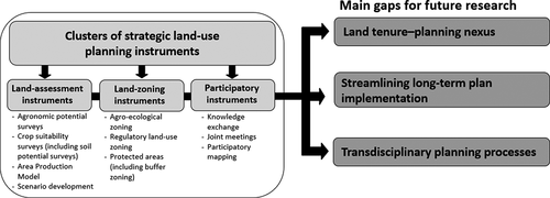
provides a summary of the mutually reinforcing perspective of the identified clusters of strategic land-use planning (SLUP) instruments and linkage to the main gaps, comprising the proposed agenda for future research. The bold arrows illustrate the interconnectedness between the SLUP instruments and the main gaps.
Figure 1. Summary of the mutually reinforcing perspective of the identified clusters of strategic land-use planning (SLUP) instruments and linkage to the main gaps composing the proposed agenda for future research. Source: Authors’ own elaboration.
Future research domain I: the articulation between land tenure and planning
Research on instruments supporting wider land tenure security, including (but not exclusively) in the form of tenure registration would aid in the importance of land-use planning in land governance. On the one hand, land titles are able to prevent or help settle conflicts or disputes between a landowner and individual households, but not necessarily between households themselves. Land titling can facilitate the development of land markets, which can constitute an instrument for facilitating the reorganization of land uses. On the other hand, legal disputes regarding land tenure could be reduced if households, occupying land illegally, secured the title deeds, however, a legal title per se does not prevent physical disputes or market pressures (De Souza, Citation2001). Land titling can thus accelerate land-use concentration and the exclusion of smallholders. For example, Russo Lopes et al. (Citation2021), in a study focused on the social impacts of soy expansion in Brazil’s Cerrado in Matopiba (Matopiba is often considered an agricultural frontier in Brazil. Matopiba’s territory comprises the Cerrado portions of the States of Maranhão, Tocantins, Piauí and Bahia), argue that even when smallholders or local communities have land titles, they still report being subject to what they call ‘silent evictions.’ This refers to distal stakeholders deliberately undermining the community’s ability to remain settled, thus gradually forcing them out. In Salta (a provincial capital in mountainous north-western Argentina), land tenure conflicts were not appropriately considered during the land-use planning process. As indicated above, the only provision made by the government to acknowledge land rights during this process was to classify some of the areas claimed by indigenous peoples (Seghezzo et al., Citation2017). Land tenure or a land registration is sustainable if it manages to administer land effectively and reflects the ownership relationships between people and land. Furthermore, in a study focused on land-use planning and tenure security dilemmas in Awash, in central Ethiopia, Chigbu et al. (Citation2019) contend that while land-use planning processes could help in overcoming issues related to land tenure insecurity, such as social conflicts, their effectiveness depends on ‘the level of collaboration, participation, acceptance of the procedures by local communities, availability of fiscal and technical resources, as well as a strong will to implement’ (p. 382). A study, focused on participatory land-use planning in Dar es Salaam City, Tanzania, M. J. Gwaleba and Masum (Citation2018) and in line with Kironde (Citation2006) and Fekade (Citation2000), further argues that the lack of tenure security could be ‘attributed by the absence of land administration and lack of proper land-use planning procedures, which do not meet people’s demand’ (p. 170). At the very least a land register should be updated to reflect inter-family alienations and land parcel mutations. However, in terms of sustainable land governance, this is not sufficient. To be effective, land tenure and land registration need to promote social cohesion and environmental justice (Chigbu et al., Citation2016). It would also be relevant to further explore the relationship between large-scale land acquisitions in tropical regions and SLUP processes. This is to understand the extent to which these land-based investments disrupt the planning processes.
Future research domain II: streamlining long-term plan implementation of strategic land-use planning decisions
Forthcoming research could investigate instruments with the potential of securing long-term decisions that have been jointly defined and are binding to public and private actors. For example, Mazza (Citation2010) highlights that if the public decision-maker is not in charge when the decision becomes effective or when plans are implemented, it is usually very difficult, if not impossible, to change or cancel the future consequences of a decision. SLUP decisions should require a large majority agreement, be politically supported and, ideally, legally binding. It is fundamental to keep tracking the implementation of plans, so they can take shape on the ground based on their true proposal, i.e. acting on the application of several instruments during the plan-making phase.
Future research domain III: developing transdisciplinary strategic land-use planning
Developing transdisciplinary SLUP could strengthen engagement and knowledge exchange initiatives between academic disciplines, such as planning, policy studies and land-use science, and practitioners and the business sector (cf. Oliveira et al., Citation2018). To our knowledge, no such efforts have been made. From the SSP literature, Albrechts (Citation2015) suggests knowledge co-production to bring together different actors to share their knowledge and expertise in the preparation of strategic plans (see also Oliveira & Hersperger, Citation2018). Sandercock (Citation1998)underlines that knowledge co-production is focused on developing socio-spatial imaginations. In this way, it ‘includes not only the views of the most articulate or powerful, but also the views of those who have been systematically excluded by structural inequalities of class, gender and religion’ (p. 65). Co-production acknowledges the value of multi-actor collaboration in planning processes to cover diverse interests related not only to economic but also social and environmental issues (Kalliomäki, Citation2015). Albrechts (Citation2016), argues that co-production, involving knowledge exchange between citizens and grassroots organizations, is needed for the more effective management of certain initiatives/issues/projects and for the dynamic that encourages transformative practices. Co-production requires careful facilitation to bridge diverse perspectives, values and identities, and multi-scalar and long-term engagement is essential for achieving outcomes (Chambers et al., Citation2021). There is also a transdisciplinary value in knowledge co-production as the process seeks to balance ‘the power scientists (may) have in framing, examining, and assessing sustainability challenges by interacting with community and policy actors that contribute tacit knowledge’ (Frantzeskaki & Rok, Citation2018, p. 49). Co-production in SLUP responds to the arguments of Sachs et al. (Citation2019), who propose several instruments for the implementation of six transformations to achieve the Sustainable Development Goals, including combining top-down visions with bottom-up experimentation across many sectors, as well as stakeholder engagement and co-production. In this regard, serious games could become an effective instrument in initiating interactions between stakeholders ‘to act according to the environment provided, not according to the outcome they would like to see for the sake of achieving their own strategic agenda’ (Barreteau et al., Citation2021, p. 178). The variety of co-production methods is in line with a growing movement away from expert-driven knowledge to community-centred knowledge and the objectives of ensuring the societal relevance of decision-making processes (Schlüter et al., Citation2021).
The three future research domains outlined are not exhaustive. In addition, and despite efforts to systematically assemble a sound set of studies, there are of course limitations to this review paper. Firstly, the study is limited to published literature in English, as it relies mainly on scientific journal articles, retrieved through the selected databases; it is likely that there are cases of instruments used to support land governance in tropical regions that are not documented in publications on SSP or land-use planning. Secondly, the literature analysis is based on results reported by other authors in those selected publications, and there is little space to control for the quality and completeness of their results, or for their selective biases. Notwithstanding, this research presents a broad reading of the state of literature on strategic approaches to land-use planning. The paper presents noteworthy insights and proposes sound future research domains, addressing challenges linked to land-use changes in tropical regions that have been changing at an accelerating pace over the last few decades, potentially threatening both the natural environment and human well-being in habitats and local communities.
Conclusion
We situate our study at the forefront of contemporary studies, bridging the strategic-foresight visions of social, economic, and ecological sustainable spatial development and the challenges related to land-use changes in tropical, low-income regions. The results of this systematic literature review have revealed several instruments that are applied in support of the preparation of land-use plans. We conclude with a research agenda, intended to overcome existing gaps. For example, land-use conflicts could be better addressed through a strategic approach to land-use planning, where long-term visions for the use of land are combined with short-term actions, which would better respond to local needs and thus secure livelihoods for rural populations and the overall governance of natural resources. This work also shows that SLUP is more effective when it is not seen by private interest groups, such as agribusiness or large-scale forestry actors as something permissive, i.e. something that can easily be overturned or disregarded in favour of personal interests or development ambitions. Instead, it should create the perception that government and planners can work together with different land-use actors to their own benefit. SLUP can work as a precursor to achieving the ‘right’ mix of integration of conservation and spatial development objectives, including land management from a social perspective and the protection of biodiversity, preventing the loss of ecosystem services. Therefore, strategic-oriented, land-use planning processes have the capability of responding to current global land-use challenges, thus supporting socio-environmental governance.
Acknowledgments
The co-authors of this paper sincerely thank two anonymous reviewers and Dr. Daniel Mueller, Editor-in-Chief of this Journal, for sharing their expertise as well as for their timely and constructive comments on earlier drafts. These comments have helped greatly to improve the manuscript. This research was conducted in the framework of the European Research Council under the European Union’s Horizon 2020 research and innovation program (Grant agreement Number 677140 MIDLAND). This study contributes to the Global Land Programme (https://glp.earth/).
Disclosure statement
No potential conflict of interest was reported by the author(s).
Additional information
Funding
References
- Albrechts, L. (2001). In Pursuit of New Approaches to strategic spatial planning. International Planning Studies, 6(3), 293–310. https://doi.org/https://doi.org/10.1080/13563470120026514
- Albrechts, L. (2015). Ingredients for a more radical strategic spatial planning. Environment and Planning B, 42(3), 510–525. https://doi.org/https://doi.org/10.1068/b130104p
- Albrechts, L. (2016). Shifts in strategic spatial planning? Some evidence from Europe and Australia. Environment & Planning A, 38(6), 1149–1170. https://doi.org/https://doi.org/10.1068/a37304
- Albrechts, L. (2017). Some ingredients for revisiting strategic spatial planning. In L. Albrechts, A. Balducci, and J. Hillier (Eds.), Situated Practices of Strategic Planning. Routledge. 389–404.
- Andronache, I., Marin, M., Fischer, R., Ahammer, H., Radulovic, M., Ciobotaru, A.-M., Jelinek, H.F., Ieva, A.D., Pintilii, R.-D., Draghici, -C.-C., Herman, G.V., Nicula, A.-S., Simion, A.-G., Loghin, I.-V., Diaconu, D.-C., & Peptenatu, D. (2019). Dynamics of forest fragmentation and connectivity using particle and fractal analysis. Scientific Reports, 9(1), 1–9. https://doi.org/https://doi.org/10.1038/s41598-019-48277-z
- Azadi, H., Hafni, H.P., Zarafshani, K., E., Witlox, F., & Witlox, F. (2011). Multi-stakeholder involvement and urban green space performance. Journal of Environmental Planning and Management, 54(6), 785–811. https://doi.org/https://doi.org/10.1080/09640568.2010.530513
- Bai, X., Dawson, R.J., Ürge-Vorsatz, D., Delgado, G.C., Barau, A.S., Dhakal, S., Dodman, D., Leonardsen, L., Masson-Delmotte, V., Roberts, D.C., & Schultz, S. (2018). Six research priorities for cities and climate change. Nature, 555(7694), 23–25. https://doi.org/https://doi.org/10.1038/d41586-018-02409-z
- Barreteau, O., Abrami, G., Bonté, B., Bousquet, F., & Mathevet, R. (2021). Serious games (Chapter 12). In R. Biggs, A.D. Vos, R. Preiser, H. Clements, K. Maciejewski, and M. Schlüter (Eds.), The Routledge Handbook of Research Methods for Social-Ecological Systems (1st ed., pp. 176–188). Routledge.
- Barton, H. (2009). Land use planning and health and well-being. Land Use Policy, 26, S115–S123. https://doi.org/https://doi.org/10.1016/j.landusepol.2009.09.008
- Becu, N., Amalric, M., Anselme, B., Beck, E., Bertin, X., Delay, E., Long, N., Marilleau, N., Pignon-Mussaud, C., & Rousseaux, F. (2017). Participatory simulation to foster social learning on coastal flooding prevention. Environmental Modelling and Software, 98, 1–11. https://doi.org/https://doi.org/10.1016/j.envsoft.2017.09.003
- Boix, L.R., & Zinck, J.A. (2008). Land-use planning in the chaco plain (Burruyacú, Argentina). Environmental Management, 42(6), 1043–1063. https://doi.org/https://doi.org/10.1007/s00267-008-9208-1
- Bourgoin, J., Castella, J.-C., Pullar, D., Lestrelin, G., & Bouahom, B. (2012). Toward a land zoning negotiation support platform: “Tips and tricks” for participatory land use planning in Laos. Landscape and Urban Planning, 104(2), 270–278. https://doi.org/https://doi.org/10.1016/j.landurbplan.2011.11.008
- Boutthavong, S., Hyakumura, K., & Ehara, M. (2017). Stakeholder Participation in REDD+ readiness activities for three collaborative projects in lao PDR. Forests, 8(5), 150. https://doi.org/https://doi.org/10.3390/f8050150
- Bruggeman, D., Meyfroidt, P., & Lambin, E.F. (2018). Impact of land-use zoning for forest protection and production on forest cover changes in Bhutan. Applied Geography, 96, 153–165. https://doi.org/https://doi.org/10.1016/j.apgeog.2018.04.011
- Bull, A.C., Plahe, J., & Gregory, L. (2021). International investment agreements and the escalation of private power in the global agri-food system. Journal of Business Ethics, 170(3), 519–533. https://doi.org/https://doi.org/10.1007/s10551-019-04333-2
- Busscher, N., Parra, C., & Vanclay, F. (2018). Land grabbing within a protected area: The experience of local communities with conservation and forestry activities in Los Esteros del Iberá, Argentina. Land Use Policy 78,572–582. https://doi.org/https://doi.org/10.1016/j.landusepol.2018.07.024
- Carlson, M.P., Fagan, K.M., Gutierrez-Velez, M.E., Macedo, V.H., Curran, M.N., DeFries, L., Dyer, R., Gibbs, G.A., Lambin, H.K., Morton, D.C., E.F., Robiglio, V., & Robiglio, V. (2014). Multiple pathways of commodity crop expansion in tropical forest landscapes. Environmental Research Letters, 9(7), 074012. https://doi.org/https://doi.org/10.1088/1748-9326/9/7/074012
- Castella, J.-C., Trung, T.N., & Boissau, S. (2005). Participatory simulation of land-use changes in the Northern Mountains of vietnam: the combined use of an agent-based model, a role-playing game, and a geographic information system. Ecology and Society, 10(1), 27. https://doi.org/https://doi.org/10.5751/ES-01328-100127
- Castella, J.C., Lienhard, P., Tran Quoc, H., Khamxaykhay, C., Phimmasone, S., Chaivanhna, S., & Phonekhampeng, C. (2020). Community-based Agricultural Development Planning (CADP): Engaging farming communities into participatory land use planning. EFICAS Know-How Series. Laos.
- CEE=Collaboration for Environmental Evidence. (2018). Guidelines and Standards for Evidence synthesis in Environmental Management. Version, 5.0. https://environmentalevidence.org/information-for-authors/table-of-contents-page/
- Chambers, J.M., Wyborn, C., Ryan, M.E., Reid, R.S., Riechers, M., Serban, A., Bennett, N.J., Cvitanovic, C., Fernández-Giménez, M.E., Galvin, K.A., Goldstein, B.E., Klenk, N.L., Tengö, M., Brennan, R., Cockburn, J.J., Hill, R., Munera, C., Nel, J.L., Österblom, H., Bednarek, A.T., … Steyaert, P. (2021). Six modes of co-production for sustainability. Nature Sustainability, 4(11), 983–996. https://doi.org/https://doi.org/10.1038/s41893-021-00755-x
- Chambers, R. (2006). Participatory mapping and geographic information systems: Whose map? Who is empowered and who disempowered? Who gains and who loses? The Electronic Journal of Information Systems in Developing Countries, 25(1), 1–11. https://doi.org/https://doi.org/10.1002/j.1681-4835.2006.tb00163.x
- Chigbu, U.E., Alemayehu, Z., & Dachaga, W. (2019). Uncovering land tenure insecurities: Tips for tenure responsive land-use planning in Ethiopia. Development in Practice, 29(3), 371–383. https://doi.org/https://doi.org/10.1080/09614524.2019.1567688
- Chigbu, U.E., Haub, O., Mabikke, S., Antonio, D., & Espinoza, J.S. (2016). Tenure Responsive Land-use planning: A Guide for Country Level Implementation. UN-Habitat.
- Conex. (1960). Land-use planning procedures. Department of Conservation and Extension, Harare, Zimbabwe.
- Daly, G. (2016). The neo-liberalization of strategic spatial planning and the overproduction of development in Celtic Tiger Ireland. European Planning Studies, 24(9), 1643–1661. https://doi.org/https://doi.org/10.1080/09654313.2016.1190813
- Dawson, N.M., Coolsaet, B., Sterling, E.J., Loveridge, R., Gross-Camp, N.D., Wongbusarakum, S., Sangha, K.K., Scherl, L.M., Phuong Phan, H., Zafra-Calvo, N., Lavey, W.G., Byakagaba, P., Idrobo, C.J., Chenet, A., Bennett, N.J., Mansourian, S., & Rosado-May, F.J. (2021). The role of Indigenous peoples and local communities in effective and equitable conservation. Ecology and Society, 26(3), 19. https://doi.org/https://doi.org/10.5751/ES-12625-260319
- de Jong, L., De Bruin, S., Knoop, J., & van Vliet, J. (2021). Understanding land-use change conflict: A systematic review of case studies. Journal of Land Use Science, 16(3), 223–239. https://doi.org/https://doi.org/10.1080/1747423X.2021.1933226
- de Souza, F.A.M. (2001). Perceived security of land tenure in Recife, Brazil. Habitat International, 25(2), 175–190. https://doi.org/https://doi.org/10.1016/S0197-3975(00)00023-0
- Debonne, N., van Vliet, J., & Verburg, P. (2019). Future governance options for large-scale land acquisition in Cambodia: Impacts on tree cover and tiger landscapes. Environmental Science & Policy, 94, 9–19. https://doi.org/https://doi.org/10.1016/j.envsci.2018.12.031
- Douma, W., Kloezen, W., & Wolvekamp, P. (1989). The Political and Administrative Context of Environmental Degradation in South India. Centre for Environmental Studies.
- Ebregt, A., & De Greve, J.P. (2000). Buffer Zones and Their Management: Policy and Best Practices for terrestrial ecosystems in developing countries. National Reference Centre for Nature Management (EC-LNV.
- Eräranta, S., & Mladenović, M.N. (2021). Networked dynamics of knowledge integration in strategic spatial planning processes: A social network approach. Regional Studies, 55(5), 870–882. https://doi.org/https://doi.org/10.1080/00343404.2020.1739637
- Ezeaku, P.I., & Davidson, A. (2008). Analytical situations of land degradation and sustainable management strategies in Africa. Journal of Agriculture and Social Sciences, 4(1), 42–52. https://agris.fao.org/agris-search/search.do?recordID=PK2008000330
- Faludi, A. (2000). The performance of spatial planning. Planning Practice & Research, 15(4), 299–318. https://doi.org/https://doi.org/10.1080/713691907
- FAO=Food and Agriculture Organization. (1993). Guidelines for Land-use Planning. Rome.
- FAO=Food and Agriculture Organization. (1996). Guidelines for Agro-Ecological Zoning. Rome.
- FAO=Food and Agriculture Organization. (1999). Guidelines for Integrated Planning for Sustainable Management of Land Resources. Rome.
- FAO=Food and Agriculture Organization. (2017). Land Use Definitions. Rome.
- Fekade, W. (2000). Deficits of formal urban land management and informal responses under rapid urban growth an international perspective. Habitat International, 24(2), 127–150. https://doi.org/https://doi.org/10.1016/S0197-3975(99)00034-X
- Frantzeskaki, N., & Rok, A. (2018). Co-producing urban sustainability transitions knowledge with community, policy and science. Environmental Innovation and Societal Transitions, 29, 47–51. https://doi.org/https://doi.org/10.1016/j.eist.2018.08.001
- Gasparri, N.I., Kuemmerle, T., Meyfroidt, P., Le Polain de Waroux, Y., & Kreft, H. (2015). The emerging soybean production frontier in southern africa: conservation challenges and the importance of South-South telecouplings. Conservation Letters, 9(1), 21–31. https://doi.org/https://doi.org/10.1111/conl.12173
- Gerber, J.-D., Nahrath, S. & Hartmann, T. (2017). The strategic use of time-limited property rights in land-use planning: Evidence from Switzerland. Environment and Planning A, 49(7), 1684–1703. https://doi.org/https://doi.org/10.1177/0308518X17701916
- Gwaleba, M.J., & Chigbu, U.E. (2020). Participation in property formation: Insights from land-use planning in an informal urban settlement in Tanzania. Land Use Policy, 92, 104482. https://doi.org/https://doi.org/10.1016/j.landusepol.2020.104482
- Gwaleba, M.J., & Masum, F. (2018). Participation of informal settlers in participatory land use planning project in pursuit of tenure security. Urban Forum, 29(2), 169–184. https://doi.org/https://doi.org/10.1007/s12132-018-9330-y
- Hall, P., Gracey, H., Drewett, R., & Thomas, R. (1973). The Containment of Urban England (George Allen and Unwin, Hemel Hempstead, Herts).
- Harrop, S.R. (2007). Traditional agricultural landscapes as protected areas in international law and policy. Agriculture, Ecosystems & Environment, 121(3), 296–307. https://doi.org/https://doi.org/10.1016/j.agee.2006.12.020
- Healey, P. (1997). The revival of strategic spatial planning in Europe. In P. Healey, A. Khakee, A. Motte, & B. Needham (Eds.), Making Strategic Spatial Plans (pp. 3–19). UCL Press.
- Hemmati, M. (2002). Multi-stakeholder processes for governance and sustainability beyond deadlock and conflict (1st ed.). Routledge.
- Henríquez-Dole, L., Usón, T.J., Vicuña, S., Henríquez, C., Gironás, J., & Meza, F. (2018). Integrating strategic land-use planning in the construction of future land-use scenarios and its performance: the maipo river Basin, Chile. Land Use Policy, 78, 353–366. https://doi.org/https://doi.org/10.1016/j.landusepol.2018.06.045
- Herrero, M., Thornton, P.K., Power, B., Bogard, J.R., Remans, R., Fritz, S., Gerber, J.S., Nelson, G., See, L., Waha, K., Watson, R.A., West, P.C., Samberg, L.H., van de Steeg, J., Stephenson, E., van Wijk, M., & Havlík, P. (2017). Farming and the geography of nutrient production for human use: A transdisciplinary analysis. The Lancet Planetary Health, 1(1), e33–e42. https://doi.org/https://doi.org/10.1016/S2542-5196(17)30007-4
- Hersperger, A.M., Grădinaru, S., Oliveira, E., Pagliarin, S., & Palka, G. (2019). Understanding strategic spatial planning to effectively guide development of urban regions. Cities, 94, 96–105. https://doi.org/https://doi.org/10.1016/j.cities.2019.05.032
- Hessel, R., van Den Berg, J., Kabore, O., van Kekem, A., Verzandvoort, S., Dipama, J.M., & Diallo, B. (2009). Linking participatory and GIS-based land use planning methods: A case study from Burkina Faso. Land Use Policy, 26(4), 1162–1172. https://doi.org/https://doi.org/10.1016/j.landusepol.2009.02.008
- Hoanh, C.T., Yen, B.T., & Trung, N.H. (2018). Participatory Land-use planning for Climate-Smart Villages: Guidelines and References. Wageningen.
- Hohl, A., & Tisdell, C. (1994). Conservation networks, integrated and sustainable land use in a tropical frontier—the Cape York Peninsula region, Australia. Environmentalist, 14(4), 253–269. https://doi.org/https://doi.org/10.1007/BF02239788
- Hopkins, L.D. (1977). Methods for generating land suitability maps: A comparative evaluation. Journal of the American Institute of Planners, 43(4), 386–400. https://doi.org/https://doi.org/10.1080/01944367708977903
- Hyman, E.L. (1984). Land-use planning to help sustain tropic forest resources. World Development, 12(8), 837–847. https://doi.org/https://doi.org/10.1016/0305-750X(84)90077-9
- IFAD=International Fund for Agricultural Development. (2014). How to Do Participatory Land-Use Planning: Land Tenure Toolkit.
- Ingalls, M., Meyfroidt, P., Xuan, P.T., Kenney-Lazar, M., & Epprecht, M. (2018). The transboundary displacement of deforestation under REDD+: Problematic intersections between the trade of forest-risk commodities and land grabbing in the mekong region. Global Environmental Change, 50, 255–267. https://doi.org/https://doi.org/10.1016/j.gloenvcha.2018.04.003
- Jere, P. (2012). Improving Land Sector Governance in Malawi. Washington, DC: World Bank. https://openknowledge.worldbank.org/handle/10986/28526
- Kalliomäki, H. (2015). Reframing strategic spatial planning as a ‘coproductive trading zone’ between state-led and place-based interests: Reflections from Maryland and Finland. Land Use Policy, 42, 113–123. https://doi.org/https://doi.org/10.1016/j.landusepol.2014.07.008
- Kaufmann, J. (1999). Future cadastres: Implications for future land administration systems bringing the world together? Proceedings of the UN-FIG International Conference on Land Tenure and Cadastral Infrastructures for Sustainable Development. Melbourne, Australia.
- Kironde, J.L. (2006). The regulatory framework, unplanned development and urban poverty: Findings from Dar Es Salaam, Tanzania. Land Use Policy, 23(4), 460–472. https://doi.org/https://doi.org/10.1016/j.landusepol.2005.07.004
- Kleemann, J., Inkoom, J.N., Shankar, T.M., Lautenbach, S., Fürst, C., & Fürst, C. (2017). Peri-urban land use pattern and its relation to land-use planning in Ghana, West Africa. Landscape and Urban Planning, 165, 280–294. https://doi.org/https://doi.org/10.1016/j.landurbplan.2017.02.004
- Kunzmann, K.R. (2010). Medium-Sized Towns, Strategic Planning and Creative Governance. In M. Cerreta, G. Concilio, and V. Monno (Eds.), Making Strategies in Spatial Planning. Urban and Landscape Perspectives (Vol. 9). Springer. 24–45.
- Laban, P. (1981). Proceedings of the workshop of land evaluation for forestry. International Workshop of the IUFRO/ISSS. Wageningen, the Netherlands.
- Lambin, E.F., Gibbs, H.K., Graue, F.L., Meyfroidt, R., Morton, P., Rudel, D.C., Gasparri, I., T.K., Munger, J., Gasparri, I., & Munger, J. (2013). Estimating the world’s potentially available cropland using a bottom-up approach. Global Environmental Change, 23(5), 892–901. https://doi.org/https://doi.org/10.1016/j.gloenvcha.2013.05.005
- Lambin, E.F., & Meyfroidt, P. (2011). Global land use change, economic globalization, & the looming land scarcity. Proceedings of the National Academy of Sciences of the United States of America, 108, 3465–3472. https://doi.org/https://doi.org/10.1073/pnas.1100480108
- Lambin, E.F., Meyfroidt, P., Rueda, X., Blackman, A., Bourner, J., Cerutti, P.O., Dietsch, T., Jungmann, L., Lamarque, P., Lister, J., Walkerk, N.F., & Wunder, S. (2014). Effectiveness and synergies of policy instruments for land use governance in tropical regions. Global Environmental Change, 28, 129–140. https://doi.org/https://doi.org/10.1016/j.gloenvcha.2014.06.007
- Lambin, M.P., Erb, K.-H., E.F., Hertel, T.W., & Hertel, T.W. (2013). Globalization of land use: Distant drivers of land change and geographic displacement of land use. Current Opinion in Environmental Sustainability, 5(5), 438–444. https://doi.org/https://doi.org/10.1016/j.cosust.2013.04.003
- Le Page, C., Bazile, D., Becu, N., Bommel, P., Bousquet, F., Etienne, M., Mathevet, R., Souchère, V., Trebuil, G., & Weber, J. (2013). Agent based modelling and simulation applied to environmental management (pp. 499–540). In B. Edmonds, and R. Meyer (Eds.), Simulating Social Complexity. Springer .
- Le Polain de Waroux, Y., Baumann, M., Gavier-Pizarro, G.N.I., Godar, G., Kuemmerle, J., Müller, T., Vázquez, R., Volante, J. N., F., Meyfroidt, P., & Meyfroidt, P. (2018). Rents, actors, and the expansion of commodity frontiers in the Gran Chaco. Annals of the American Association of Geographers, 108(1), 204–225. https://doi.org/https://doi.org/10.1080/24694452.2017.1360761
- Lestrelin, G., Castella, J.-C., & Bourgoin, J. (2012). Territorializing sustainable development: The politics of land-use planning in the Lao PDR. Journal of Contemporary Asia, 42(4), 581–602. https://doi.org/https://doi.org/10.1080/00472336.2012.706745
- Mäntysalo, R., Kangasoja, J.K., & Kanninen, V. (2015). The paradox of strategic spatial planning: A theoretical outline with a view on Finland. Planning Theory and Practice, 16(2), 169–183. https://doi.org/https://doi.org/10.1080/14649357.2015.1016548
- Mascia, M.B., Pailler, S., Krithivasan, R., Roshchanka, V., Burns, D., Mlotha, M.J., Murray, D.R., & Peng, N. (2014). Protected area downgrading, downsizing, & degazettement (PADDD) in Africa, Asia, & Latin America and the Caribbean, 1900–2010. Biological Conservation, 169, 355–361. https://doi.org/https://doi.org/10.1016/j.biocon.2013.11.021
- Masterson, V.A., Enqvist, J.P., Stedman, R.C., Tengö, M., Stedman, R.C., & Tengö, M. (2019). Sense of place in social–ecological systems: From theory to empirics. Sustainability Science, 14(3), 555. https://doi.org/https://doi.org/10.1007/s11625-019-00695-8
- Mather, A.S. (2007). Recent Asian forest transitions in relation to forest-transition theory. International Forestry Review, 9(1), 491–502. https://doi.org/https://doi.org/10.1505/ifor.9.1.491
- Mazza, L. (2010). Notes on strategic processes in land use planning. In M. Cerreta, G. Concilio, and V. Monno (Eds.), Making Strategies in Spatial Planning. Urban and Landscape Perspectives. Springer 79–85 .
- McCall, M.K., & Dunn, C.E. (2012). Geo-information tools for participatory spatial planning: Fulfilling the criteria for good governance. Geoforum, 43(1), 81–94. https://doi.org/https://doi.org/10.1016/j.geoforum.2011.07.007
- McMichael, P. (2013). Land grabbing as security mercantilism in international relations. Globalizations, 10(1), 47–64. https://doi.org/https://doi.org/10.1080/14747731.2013.760925
- Mendoza-Ponce, A., Corona-Núñez, R.O., Galicia, L., & Kraxner, F. (2019). Identifying hotspots of land use cover change under socioeconomic and climate change scenarios in Mexico. Ambio, 48(4), 336–349. https://doi.org/https://doi.org/10.1007/s13280-018-1085-0
- Nackoney, J., Rybock, D., Dupain, J., & Facheux, C. (2013). Coupling participatory mapping and GIS to inform village-level agricultural zoning in the Democratic Republic Of The Congo. Landscape and Urban Planning, 110, 164–174. https://doi.org/https://doi.org/10.1016/j.landurbplan.2012.11.004
- Nolte, C., Gobbi, B., Le Polain de Waroux, Y., Piquer-Rodríguez, M., Butsic, V., & Lambin, E.F. (2017). Decentralized Land-use zoning Reduces Large-scale Deforestation in a Major Agricultural Frontier. Ecological Economics, 136, 30–40. https://doi.org/https://doi.org/10.1016/j.ecolecon.2017.02.009
- O’Sullivan, R., & Norfolk, J. (2017). Improving tenure security to support sustainable cocoa – Implementation Plan. USAID.
- Oliveira, E., & Hersperger, A.M. (2018). Governance arrangements, funding instruments and power configurations in current practices of strategic spatial plan implementation. Land Use Policy, 76, 623–633. https://doi.org/https://doi.org/10.1016/j.landusepol.2018.02.042
- Oliveira, E., & Hersperger, A.M. (2019). Disentangling the governance configurations of strategic spatial plan-making in European Urban regions. Planning Practice & Research, 34(1), 47–61. https://doi.org/https://doi.org/10.1080/02697459.2018.1548218
- Oliveira, E., Leuthard, J., & Tobias, S. (2019). Spatial planning instruments for cropland protection in Western European countries. Land Use Policy, 87, 104031. https://doi.org/https://doi.org/10.1016/j.landusepol.2019.104031
- Oliveira, E., Tobias, S., & Hersperger, A.M. (2018). Can SSP Contribute to Land Degradation Reduction in Urban Regions? State of the Art and Future Research. Sustainability, 10(4), 949. https://doi.org/https://doi.org/10.3390/su10040949
- Osabuohien, E. (2015). Handbook of Research on In-Country Determinants and Implications of Foreign Land Acquisitions (pp. 1-495). IGI Global.
- Pacheco, P., Mo, K., Dudley, N., Shapiro, A., Aguilar-Amuchastegui, N., Ling, P.Y., Anderson, C., & Marx, A. (2021). Deforestation fronts: Drivers and responses in a changing world. World Wide Fund for Nature.
- Peña-Claros, M., Blommerde, S., & Bongers, F. (2009). Assessing the progress made: an evaluation of forest management certification in the tropics. In Tropical Resource Management Papers (Vol. 95, pp. 1–76). https://edepot.wur.nl/137012
- Piquer‐Rodríguez, M., Baumann, M., Butsic, V., Gasparri, H.I., Gavier-Pizarro, G., Volante, J.N., Müller, D., & Kuemmerle, T. (2018a). The potential impact of economic policies on future land-use conversions in Argentina. Land Use Policy, 79, 57–67. https://doi.org/https://doi.org/10.1016/j.landusepol.2018.07.039
- Piquer‐Rodríguez, M., Butsic, V., Gärtner, P., Macchi, L., Baumann, M., Gavier Pizarro, G., Volante, J.N., Gasparri, I.N., & Kuemmerle, T. (2018b). Drivers of agricultural land-use change in the Argentine Pampas and Chaco regions. Applied Geography, 91, 111–122. https://doi.org/https://doi.org/10.1016/j.apgeog.2018.01.004
- Poku-Boansi, M. (2021). Multi-stakeholder involvement in urban land use planning in the Ejisu Municipality, Ghana: An application of the social complexities’ theory. Land Use Policy, 103, 105315. https://doi.org/https://doi.org/10.1016/j.landusepol.2021.105315
- Ramakrishna, N. (2003). Production system planning for natural resource conservation in a micro watershed. Electronic Green Journal, 1(18), 1–10. https://doi.org/https://doi.org/10.5070/G311810507
- Ramankutty, R.V., Mehrabi, N., Jarvis, L., Z., Chookolingo, B., & Chookolingo, B. (2018). How much of the world’s food do smallholders produce? Global Food Security, 17, 64–72. https://doi.org/https://doi.org/10.1016/j.gfs.2018.05.002
- Rindfuss, R.R., Entwisle, B., Walsh, S.J., Mena, C.F., Erlien, C.M., & Gray, C.L. (2007). Frontier land use change Synthesis, challenges and next steps. Annals of the Association of American Geographers, 97(4), 739–754. https://doi.org/https://doi.org/10.1111/j.1467-8306.2007.00580.x
- Rotich, D. (2012). Concept of zoning management in protected areas. Journal of Environmental Earth Science, 2(10), 173–183. https://iiste.org/Journals/index.php/JEES/article/view/3309
- Rudel, T. K. & Meyfroidt, P. (2014). Organizing anarchy: The food security–biodiversity–climate crisis and the genesis of rural land use planning in the developing world. Land Use Policy, 36, 239–247. https://doi.org/https://doi.org/10.1016/j.landusepol.2013.07.008
- Russo Lopes, G., Bastos Lima, M.G., & Dos Reis, T.N.P. (2021). Maldevelopment revisited: Inclusiveness and social impacts of soy expansion over Brazil’s Cerrado in Matopiba. World Development, 139, 105316. https://doi.org/https://doi.org/10.1016/j.worlddev.2020.105316
- Sachs, J.D., Rockström, J., Rockström, J., Rockström, J., Rockström, J., & Rockström, J. (2019). Six Transformations to Achieve the Sustainable Development Goals. Nature Sustainability, 2, 805–814. https://doi.org/https://doi.org/10.1038/s41893-019-0352-9
- Samberg, L.H., Gerber, J.S., Ramankutty, N., Herrero, M., & West, P.C. (2016). Subnational distribution of average farm size and smallholder contributions to global food production. Environmental Research Letters, 11(12), 124010. https://doi.org/https://doi.org/10.1088/1748-9326/11/12/124010
- Sandercock, L., (1998). Making the Invisible Visible: A Multicultural Planning History. Berkeley: University California Press.
- Sandewall, M., & Nilsson, N.-E. (2001). The Area Production Model: A tool and concept for sustainable land-use and forest-resource management. Journal of Environmental Management, 62(4), 415–427. https://doi.org/https://doi.org/10.1006/jema.2001.0450
- Sandewall, M., Ohlsson, B., & Sawathvong, S. (2001). Assessment of historical land-use changes for purposes of strategic planning: A case study in Laos. Ambio, 30(1), 55–61. https://doi.org/https://doi.org/10.1579/0044-7447-30.1.55
- Sawathvong, S. (2004). Experiences from developing an integrated land-use planning approach for protected areas in the Lao PDR. Forest Policy and Economics, 6(6), 553–566. https://doi.org/https://doi.org/10.1016/S1389-9341(03)00005-4
- Sayer, J. (1991). Rainforest Buffer Zones. Guidelines for protected area managers.
- Schlüter, M., Lindkvist, E., Wijermans, N., & Polhill, G. (2021). Agent-based modelling (Chapter 28). In R. Biggs, A.D. Vos, R. Preiser, H. Clements, K. Maciejewski, and M. Schlüter (Eds.), The Routledge Handbook of Research Methods for Social-Ecological Systems (1st ed.). Routledge. 383–397.
- Schmidt-Traub, G., Obersteiner, M., & Mosnier, A. (2019). Fix the broken food system in three steps. Nature, 569(7755), 181–183. https://doi.org/https://doi.org/10.1038/d41586-019-01420-2
- Searle, G. (2017). Strategic planning and land-use planning conflicts. In L. Albrechts, A. Balducci, and J. Hillier (Eds.), Situated Practices of Strategic Planning. Routledge. 317–330.
- Seghezzo, L.V., Buliubasich, E.C., C., Iribarnegaray, M.A., Volante, J.N., & Volante, J.N. (2017). Participatory, multi-criteria evaluation methods as a means to increase the legitimacy and sustainability of land-use planning processes. the case of the chaco region in salta, Argentina. Environmental Management, 59(2), 307–324. https://doi.org/https://doi.org/10.1007/s00267-016-0779-y
- Shaxson, T.F., Hudson, N.W., Sanders, D.W., Roose, E., & Moldenhauer, W.C. (1977). Land Husbandry: A Framework for Soil and Water Conservation. Soil and Water Conservation Society.
- Speelman, E.N., van Noordwijk, M., & Garcia, C. (2017). Gaming to better manage complex natural resource landscapes. In S. Namirembe, B. Leimona, M. van Noordwijk, and P. Minang (Eds.), Coinvestment in ecosystem services: Global lessons from payment and incentive schemes (pp. 1–11). World Agroforestry Centre (ICRAF). https://www.worldagroforestry.org/publication/gaming-better-manage-complex-natural-resource-landscapes
- Steppler, H.A., and Nair, P.K.R., Eds. (1987). In Agroforestry a decade of development. Nairobi, Kenya: International Council for Research in Agroforestry. 92 9059 036 X. http://apps.worldagroforestry.org/downloads/Publications/PDFS/B03842.pdf
- Suhardiman, D., Keovilignavong, O., & Kenney-Lazar, M. (2019). The territorial politics of land-use planning in Laos. Land Use Policy, 83, 346–356. https://doi.org/https://doi.org/10.1016/j.landusepol.2019.02.017
- Tang, Z., Hussey, C.M., & Wei, T. (2009) Assessing local land use planning’s awareness, analysis, and actions for climate change. Community and Regional Planning Program: Faculty Scholarly and Creative Activity. 7.
- Tellman, B., Magliocca, N.R., Turner, I.I.B.L., & Verburg, P.H. (2020). Understanding the role of illicit transactions in land-change dynamics. Nature Sustainability, 3(3), 175–181. https://doi.org/https://doi.org/10.1038/s41893-019-0457-1
- Toolsie, D. (1967). Agricultural and farm planning on the basis of land capability surveys with particular reference to Trinidad And Tobago. 2nd West Indies Agricultural Economics Conference April 7-11 1967. Trinidad and Tobago: Caribbean Agro-Economic Society. 153–166. St. Augustine, Trinidad. https://ageconsearch.umn.edu/record/263881
- Valencia-Sandoval, C., Flanders, D.N., & Kozak, R.A. (2010). Participatory landscape planning and sustainable community development: Methodological observations from a case study in rural Mexico. Landscape and Urban Planning, 94(1), 63–70. https://doi.org/https://doi.org/10.1016/j.landurbplan.2009.07.018
- Van Assche, K., Gruezmacher, M., & Deacon, L. (2019). Land use tools for tempering boom and bust: Strategy and capacity building in governance. Land Use Policy, 93, 103994. https://doi.org/https://doi.org/10.1016/j.landusepol.2019.05.013
- Van Gool, D., Tille, P.J., & Moore, G.A. (2005). Land evaluation standards for land resource mapping: Assessing land qualities and determining land capability in south-western Australia 298. Western Australia, Perth: Department of Primary Industries and Regional Development. https://researchlibrary.agric.wa.gov.au/rmtr/280/
- Van Oosten, C., & Merten, K. (2021). Securing Rights in Landscapes: Towards a Rights Based Landscape Approach. Wageningen Centre for Development Innovation, Wageningen University & Research (WUR.
- Verburg, P., Soepboer, W., Veldkamp, A., Limpiada, R., Espaldon, V., & Mastura, S.S.A. (2002). Modeling the spatial dynamics of regional land use: The CLUE-S model. Environmental Management, 30(3), 391–405. https://doi.org/https://doi.org/10.1007/s00267-002-2630-x
- Weimer, D.L. (2008). Theories of and in the Policy Process. Policy Studies Journal, 36(4), 489–495. https://doi.org/https://doi.org/10.1111/j.1541-0072.2008.00280.x
- Wood, D. (1995). Conserved to death: Are tropical forests being over-protected from people? Land Use Policy, 12(2), 115–135. https://doi.org/https://doi.org/10.1016/0264-8377(94)00003-I
- Young, A. (1989). Agroforestry for Soil Conservation. CABI Publishing.
- Yu, D., Xie, P., Dong, X., Su, B., Hu, X., Wang, K., & Xu, S. (2018). The development of land-use planning scenarios based on land suitability and its influences on eco-hydrological responses in the upstream of the Huaihe River basin. Ecological Modelling, 373, 53–67. https://doi.org/https://doi.org/10.1016/j.ecolmodel.2018.01.010
- ZDA=Zambia Department of Agriculture. (1977). Land-use planning guide (pp. 256). Zambia: Zambia Department of Agriculture Land Use Branch.
- Zscheischler, J., Rogga, S., & Busse, M. (2017). The adoption and implementation of transdisciplinary research in the field of land-use science—a comparative case study. Sustainability, 9(11), 1926. https://doi.org/https://doi.org/10.3390/su9111926