
ABSTRACT
In 2019, government of Thailand recognized community-based forest management and gave rights to communities to manage their forests. We evaluated the effectiveness of long-established community managed forests in conserving tree cover in Nan province, Thailand. We mapped boundaries of all community managed forests patches to understand their spatial distribution and their overlap with national parks and national forests. We analysed Landsat images between 2000–2019 to map forest-cover changes. Using genetic matching, we compared the effectiveness of various management categories in conserving forests, controlling for covariates. We found that, despite high rates of deforestation in the province, community managed forests are well conserved. Moreover, forests patches in national parks and national forests are better conserved when they overlap with community managed forests. Community forests, as a bottom-up land use institution, are effective in forest conservation. They provide an extra layer of forest protection along with national forests and national parks.
Introduction
Forest conservation can be promoted through a combination of command-and-control institutions, such as national parks or national forests, and through ‘bottom up’ institutions, such as community-managed forests. Community forests are defined as an institution that provides rights to the communities to utilize, protect, and govern forest lands and forest resources, so that communities can freely access the forest land, perform their religious rituals, protect the forest and watersheds from outsiders as well as sustainably utilize forest resources (Charnley & Poe, Citation2007; Pelletier et al., Citation2016). Community forest management is found to be the most cost-effective forest management strategy and is effective in conserving biodiversity (Somanathan et al., Citation2009). It also reduces poverty (Adam & Eltayeb, Citation2016; Oldekop et al., Citation2019), especially in developing countries. However, worldwide, most forests are formally administered by central/state governments either as protected areas or national forests (Adams & Hutton, Citation2007). Even though formal, decentralized forest policies have existed since the mid-1980s, local communities still struggle in many parts of the world to obtain the rights, recognition, and authority to use their local forest resources (Andersson & Gibson, Citation2006; Pagdee et al., Citation2006). Recently the narrative around forest governance has changed with the involvement of non-state actors such as local and international NGOs, local communities, international donors, and the private sector (Furumo & Lambin, Citation2021). This shift is explained by international concerns about deforestation given its influence on climate change and biodiversity loss, social pressures for local resource governance, eco-certification of forest commodities, land privatization, and market-based incentives for sustainable resource management (Agrawal et al., Citation2008). Decentralized policies span a spectrum from local communities working for government agencies, jointly co-managing the forest with the government, or having an independent decision-making body for forest management.
A rich scholarship exists on the governance of common pool resources (Agrawal, Citation1999; Dietz et al., Citation2003; Ostrom, Citation1990). Elinor Ostrom has designed a set of principles for community-based natural resource management that are key for an effective governance system (Ostrom, Citation1990). Given the complexity associated with common pool resource management, these principles do not hold true in all cases, mainly due to fuzzy boundaries, heterogenous groups, inherited inequality, local politics, and lack of support from governments (Cox et al., Citation2010). However, these principles help understand the circumstances under which community management can be sustained over the long-term. These principles fit well with the case of forests because, unlike fisheries, irrigated systems, and groundwater systems, forests have clear boundaries and their condition can be easily monitored by local communities, provided they receive adequate support from local authorities (Araral, Citation2014; Berkes, Citation2006). Therefore, decentralized policies are more common in the forestry sector, especially in developing countries. A recent survey noted a 40% increase in legal forest rights allocated to local communities since 2002, of which 98% of forests are in developing countries and about 28% are under local community management in these countries (Rights and Resources, Forest and Land Tenure).
Hajjar et al. (Citation2016) reviewed community forest management studies globally and found that the literature is predominately from South Asia (mostly India and Nepal), Latin America and Africa. Data from East Africa, Latin America and South Asia have shown that community-managed forests perform better in terms of livelihood support and carbon storage when local communities have the authority to make decisions for sufficiently large forest patches and when government or non-government organizations provide support and incentives (Chhatre & Agrawal, Citation2009). Under these conditions, local communities felt less insecure about their land rights and conserved greater biomass as compared to forest patches that are centrally governed.
Communities having clear rights over forest land have always been under scrutiny by forest managers and governments, whether or not these communities are able to sustainably manage the forests (Pagdee et al., Citation2006). In India, the role of communities in managing forests was recognized in the late 1990s under the Joint Forest Management policy. However, due to the top-down approach of this policy and the lack of land tenure rights, it was not very successful (Kumar, Citation2002; Ravindranath & Sudha, Citation2004). Forest Department officials are part of the joint executive committees and have the authority to form and change rules. Later, under the Forest Rights Act of 2006, local communities obtained legal rights over community forests. The effect of India’s community forest management in sustaining forest resources is still under debate (Kutty et al., Citation2019). Similarly, in the Philippines a decentralized policy was initiated, which created opportunities as well as constraints for local communities (Magno, Citation2001). With strong civil society support and political struggles, a community-based forest management program was initiated in 1992 to sustainably manage forest resources and administer social justice. However, an effective implementation of local authority on forest resources is still questionable (Magno, Citation2001). Vietnam has also decentralized its forest policy since 1990. Following a series of changes in forest protection laws in 2003–2004, a legal status has been provided to local communities for managing forests. However, the allocation of these rights to communities has been poor due to a lack of communication, especially in northern Vietnam, a region with high poverty and many ethnic minorities (Pinyopusarerk et al., Citation2014). A recent study found that payments for forest environmental services and clarification of forest boundaries have led to better forest management in Vietnam (Duong & De Groot, Citation2020). The struggle to establish local governance persists due to government motivations such as rent seeking, discursive power, and institutionalized incentives (Fleischman, Citation2014).
To help institutions of community-based forest management overcome their struggle against state-level bureaucracy, one requires a better understanding of their impact on forest cover, biodiversity, climate change, economic development, and social well-being. Even though community forests management is prevalent in developing countries, literature reviews by Hajjar et al. (Citation2016), Hajjar and Oldekop (Citation2018), Burivalova et al. (Citation2019), and Börner et al. (Citation2020) identified a scarcity of studies on the effectiveness of decentralized forest management based on robust experimental methods. Recent case studies have focused on the impact of community-based forest management using experimental and quasi-experimental based evidence from southern Africa, Latin America, and Asia (Bruggeman et al., Citation2015; Oldekop et al., Citation2019; Sills et al., Citation2020). The case study from Indonesia showed the influence of the political economy on conservation policy (Miteva & Pattanayak, Citation2021). The studies also showed the importance of social welfare (Okumu & Muchapondwa, Citation2020), frequent election of the leaders (Kahsay & Medhin, Citation2020), enhanced extra savings (Gelo, Citation2020), polycentric governance approaches (Sills et al., Citation2020), and cooperative behaviors (Bluffstone et al., Citation2020) in maintaining and sustaining the decentralized policies with positive socio-economic and forest conservation outcomes.
Until recently, Thailand has been lacking in providing rights to local communities for managing their surrounding forests. In 2019, under the Community Forest Act 65 (B.E. 2562), the Thai government mandated that community leaders register the forest patches protected by their community by 25 November 2019 and that the Forest Department maps these forests patches by 23 July 2020. Non-compliance would lead to government taking over the forest land. Around 11,327 community forest committees were registered in Thailand, covering approximately 1 million hectare forests by 2019 (Ganz & Rattanarat, Citation2021).
The objective of this study was to evaluate the effectiveness of traditional community forest management in conserving forest cover in Nan province, Thailand. In this northern province, forest patches have been managed by communities through their customary laws and practices for a long time. We evaluated whether the community-managed forests maintained their forest cover between 2000–2019 using a robust experimental method, genetic matching. We compared the three main forest management institutions in Nan province: national forests, national parks, and community forests. The national forests and national parks are clearly and formally demarcated whereas no official information was available on community forests. We mapped approximately 2000 community forest patches and compared forest cover changes under different forest institution categories based on time series of Landsat satellite images.
Study area
Overview
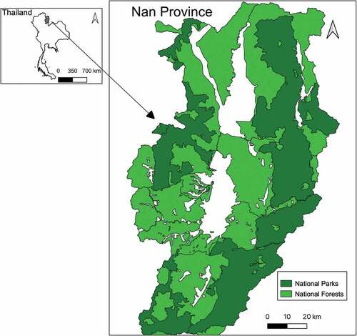
Nan province is situated in the northern part of Thailand, along the border with Laos. The landscape is mountainous, with elevations ranging from 700 to 2300 m. The central part of Nan province is a large valley, referred to as lowlands, surrounded by mountains, referred to as highlands. The total area of Nan province is 12,347.27 km2, of which 15% is in lowlands and 85% in highlands. Nan’s population is around 500,000, mostly farmers that used to practice swidden cultivation in highlands and have permanent crop fields in lowlands. Nan has seven national parks. Forests outside national parks are managed as national forests by the Royal Forest department (). Together, national parks and national forests cover most of the highland forests. Some of the forests in Nan province are also managed by the communities living in and around forest patches.
Figure 1. Spatial distribution of national parks and national forests in Nan province. Areas in white on the map represent non-forest uses such as agriculture, water, and fallow land.
History of community forests
Community forest management has existed for a long time in Nan province. People’s livelihoods were dependent on forests, and with time, they accumulated knowledge on forest ecology and livelihood sources from forests. In 1964, motivated by national development, the Thai government announced the National Forest Reserve Act. Soon the community managed forests became state/public property. There was a monopolization of timber production and logging concessions in national reserved forests across the country. Many business companies entered and operated logging in forests of the main watershed of the Nan River. In 1975, communities from Ban Luang district strongly opposed the practices of logging companies, which finally agreed to withdraw. Following this incident, these communities established rules for preserving their forests as a sustainable heritage. Their initiative then expanded to many nearby areas in the form of a provincial network of community forestry (Sairorkham & Sakitram, Citation2020).
Advocating for forest protection has also become the focus of local NGOs that have joined the movement. Subsequently, the community movement for forest management has evolved with mentoring agencies. In 1991, communities joined the Northern Community Forestry Network to get support from policy and advocate for legalization. In 1993–2001, the Nan Community Forestry Network mobilized about 50,000 people and proposed the Community Forest Law, which has resulted in a social movement to focus on Community Forest Act, People’s Edition. As a result, the discourse on community rights and community forests were widely recognized by policymakers. However, since 2003, due to constant negotiations, struggles with the government on community forest rights, and land tenure issues, community leaders had to back off. During this period, the social movement and network mechanisms began to weaken. Community forest management also suffered due to the lack of support from the young generation, which migrated to cities for jobs, and given insufficient funds to sustain community forest operations. Despite these struggles, Nan province still has numerous forest patches under community forest management. These remaining forests are the result of efforts by local communities to preserve forests (Sairorkham & Sakitram, Citation2020).
In the early period of community forest management, local communities played a central role, without any guidance from the authorities. Their efforts were later recognized by various civil society, academic and government organizations. In 2018, the project ‘Empowering and revitalizing the community forestry network project in Nan province’ was developed in collaboration with local NGOs. They were many interactions, both collaborative and confrontational, among stakeholders. After a period of stagnation, the community forest network, local NGOs, and academics worked together to further develop community forest institutions (Sairorkham & Sakitram, Citation2020).
Categories of community forests
A study by Sairorkham and Sakitram (Citation2020) revealed that there are three types of community forests in Nan province. ‘Watershed forests’ are areas protected or restricted by the community, with strict rules such as a complete prohibition on logging. Villagers are allowed to collect non-timber forest products for consumption. For example, Khun Huai Si Phan is an important watershed, and villagers in Saud and Pa Kha Luang sub-districts, of Ban Luang district, are dependent on it. In 1973, a sawmill was contracted to extract timber from the forest. The village leader requested the provincial governor to stop the logging, but their request was rejected. In 1975, community leaders and villagers protected the forest by blocking the road. The sawmill owner finally withdrew. As another example, villagers of Sila Lang subdistrict traditionally complied with the prohibition on logging large timber as their forest covers an important watershed area upstream of Nan. Later, due to the relocation of other hill-tribes, the forest was encroached for cultivation. In 1970, all villagers suffered from a severe drought. The sub-district headman explained the severity of impacts to the recent settlers and provided cropland elsewhere. Community leaders also conducted a campaign and sought cooperation from the hilltribes to stop deforestation. Over 5 years, they conserved around 5,760 ha of forest area. In 1985, a community forest conservation committee was formed to monitor the forest on a monthly basis to prevent illegal logging. In 1989, the committee evolved into a ‘watershed forest conservation committee’ which was established by the Sila Laeng Sub-District Council Regulation on Forest Conservation. At present, most forests of Sila Laeng sub-district community are located inside the Doi Phu Kha National Park, formed in 1999. There are community forest patches inside the national park which are still maintained by the community. Villagers get water, fish, food, and herbs from the forest. They are allowed to collect logs to build their house with permission from the community forest leaders.
‘Usable forests’ are conserved by the community, whose members can use the forest under the community rules. Non-timber forest products and timber can be collected, and timber can only be used for public activities and by community members who face hardship. For example, in 1987, Ban Kiew Muang in Santisuk district faced severe water shortages. At that time, the Royal Forest Department declared a national forest reserve, which overlapped with community forests. The government agencies had encouraged private organizations to plant eucalyptus trees in degraded forest areas. Local communities instead established the Kiew Muang Forest Conservation Group to jointly preserve the forests area. The group set up regulations on forest management and encouraged villagers to grow fruit trees, collect non-timber forest products, and grow perennials in wastelands and around rice fields.
‘Ritual forests’ are used for performing rituals according to the beliefs of the community. Most community members do not dare to exploit this forest. They are also fearful of supernatural forces. For example, a local monk, Phrapalad Sa-nguan, used the strategy ‘Buddhism Plus Spiritualism’ to conserve local forests. He conducted tree ordinations, which the villagers respect. The villagers would put a spirit house next to a large tree that is considered as a principal tree. Starting in 1990, Phrapalad Sa-nguan conducted forest ordination ceremonies in collaboration with several groups, which prevented people cutting down trees. The community groups who joined forest ordination ceremonies formed a ‘community forum’ to conserve their forest using this approach. Worship of monks and fear of spirits have been considered as an effective solution to conserve forest (Darlington, Citation2012).
Methods
Mapping of community forests
We collected information on boundaries of community managed forests, with the permission of leaders of the Nan community forestry network to survey community forests in all sub-districts. The mapping involved collecting boundary information from community leaders and representatives of community forest management using Google Earth images. The boundary information was further matched with old maps and secondary information from the Royal Forest Department. Some community forest boundaries had already been documented in the form of certificate of ownership of community property. Some areas were also surveyed by the local administration, which shared shape files. The information collected on community forests boundaries were reconfirmed with the community leaders. Interviews with community leaders and representatives of community forest management were also conducted using a structured questionnaire about forest name, number of forest patches, community forests in national parks and national forests, registration with the Royal Forest Department, and community forest rules.
Landsat image classification
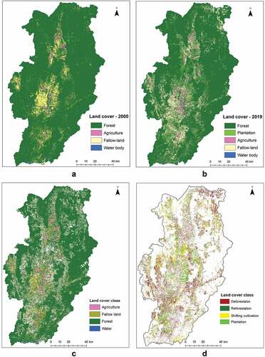
We used supervised image classification of Landsat satellite images of 2000 and 2019 to map forest cover in Nan province. Cloud-free images from Landsat 5 ETM for 2000, and Landsat 8 OLI/TIRS 2019 were selected for the classification. The selected images were from February and March, the months with least cloud cover. We selected the best possible combinations of Landsat images with near anniversary dates. We used the blue, green, red, NIR, SWIR 1, and SWIR 2 spectral bands. We also computed indices that help discriminate between forests, agriculture, and water: Normalized Difference Vegetation Index (NDVI), Normalized Difference Moisture Index (NDMI) and Soil Adjusted Vegetation Index (SAVI; Agarwal & Nagendra, Citation2020).
Based on Google Earth imagery, representative areas of interest were identified and digitized for each time period. The Random Forest classifier, which is a highly robust pixel-based supervised classification method, was used to classify the images. This classification method is robust because it is not sensitive to over-training, can handle multi-dimensional data and collinearity, and is known to produce high accuracies (Belgiu & Drăguţ, Citation2016). Land cover categories included forest, agricultural land (including tree crops for the 2000 images, except for dense rubber plantations), fallow land, and water. A tree plantation category was added for the year 2019 classification as plantation area had increased in recent years and the improved spectral resolution of the Landsat 8 sensor decreased confusion with other classes. All the above image processing steps were conducted in Google Earth Engine.
A change detection between the 2000 and 2019 images was undertaken using a hybrid method that combines image differencing and classification overlays. It identified areas under deforestation, reforestation, and plantation, along with the stable land cover classes. As farmers in Nan practice shifting cultivation, the deforestation class was further divided into deforestation and shifting cultivation () (see, Agarwal & Lambin, Citation2022 for details of the change detection method).
Figure 2. (a) Land cover from 2000; (b) Land cover 2019; (c) Stable land cover classes between 2000 and 2019; (d) Land cover change classes between 2000 and 2019.
Accuracy assessment
Around 350 random points were generated for accuracy assessment, based on the proportion of land cover under each class in the 2019 classified image (Congalton, Citation1991). Approximately 100 points covered forests and fallows and 50 covered agriculture, water, and plantations. The same points were used for accuracy assessment of the 2000 classified images. Classification accuracy was assessed using Google Earth images of the corresponding time periods. Error matrices were generated to calculate producer accuracy, user accuracy, and kappa statistics.
Genetic matching
The genetic matching method was used to create quasi-experimental conditions. Forest conservation efforts are affected by a well-known adverse selection bias – i.e. protected areas tend to be located in areas with lower deforestation pressure (Cuenca et al., Citation2016). Therefore, there is a risk of overestimating the effectiveness of protected areas (Abadie & Imbens, Citation2011). The genetic matching method corrects for this bias by creating a counterfactual by controlling for the effect of covariates that might influence changes in forest cover – i.e. elevation, slope, aspect, village population, distance from village, distance from road, and number of households (). It compares a large sample of randomly selected points within and outside protected areas that are similar with respect to these covariates (Bruggeman et al., Citation2018). These form treatment and control samples, respectively. The method therefore isolates the effect of the forest management institution from the effect of the landscape variables associated with the adverse selection bias (Abadie & Imbens, Citation2011; Ferraro et al., Citation2015).
Table 1. Description of control and outcome variables.
We randomly selected 10,000 forest pixels, divided equally between the control and treatment groups, to analyze whether the forest pixels in 2000 remained forest or had changed to any other non-forest land cover class in 2019. Sampling was constrained by a 250 meters minimum distance between observations to minimize spatial autocorrelation. This constraint limited the sample size. We computed semi-variograms and found a low spatial autocorrelation at a 250 m sampling distance (semi-variance < 0.12). In Nan province, farm size varies from 3 to 5 rai (1 rai = 1600 m2). Thus, forest clearing for agriculture is likely to occur in plots at distances >150 – 250 m apart. A random sample of 5000 pixels was deemed statistically representative of our treatments as it represents 2.1% of the population of pixels of community forests inside national forests, 3.3% for community forests inside national parks, 1.3% for community forests inside national forests and national parks, and 0.5% of national parks only.
We collected information on village population and number of households from a 2015 national report. Distance from the nearest village and road were calculated using spatial analysis in R version 3.6.2. We also extracted values for elevation, slope and aspect using open-source dataset of Shuttle Radar Topography Mission (SRTM) for the globe version 4 at 90 m resolution ().
We used the genetic matching method in R version 3.6.2 based on the GenMatch package (Sekhon, Citation2008). To measure the difference between the effectiveness of different forest institutions for the treatment and control samples, we used the average treatment effect (ATE) method (Bruggeman et al., Citation2018). We also used calipers to improve the matching, as it replaces the matching outside of a tolerance level, defined here at 0.25 standard deviations.
We performed Placebo tests to check the robustness of our results. These tests allow confirming that the forest protection institution is the only source of variation across treatment and control, and that there are no hidden covariates causing these differences (Nolte et al., Citation2017). Placebo tests allow detection of any insignificant difference between placebo treatment and control groups. We defined our placebo group as pixels from the matched control group, i.e. that are not community managed forest (or not national parks for one analysis). Next, we matched these ‘placebo treatment’ groups to remaining control group pixels that were similar to the placebo pixels in terms of covariates. If differences between placebo treatment groups and their matched controls are small and not statistically significant, then the matching successfully controls for confounding variables and produces a reliable counterfactual (Nolte et al., Citation2017).
As community forests existed before establishment of protected areas, these two categories may overlap. Therefore, in the evaluation of forest-cover changes, four comparisons were made: (1) Community forests inside national forests (treatment) versus national forests without national parks and community forests (control); (2) Community forests inside national parks (treatment) versus national parks without community forests (control); (3) Community forests inside national forests and national parks (treatment) versus national forests or national parks without community forests (control) (in this experiment, the location of forest pixels in national parks or national forests was included as a covariate); (4) National parks (treatment) versus forests outside of national parks (control).
Results
Mapping of community forests
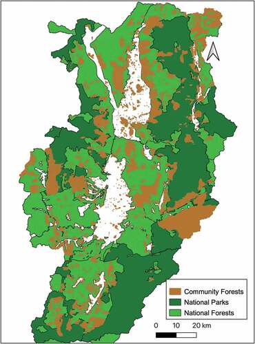
We found 1950 community forests patches in Nan province. As much as 16% of the province’s forest area is under community forests: 9% inside national forests, 6% inside national parks, and 1% outside national forests and national parks. There are 7 national parks and 2 wildlife sanctuaries representing together 48% of the area of the Nan province. National forests represent 86% of the area of the Nan province, out of which 39% do overlap with neither national parks, nor community forests ().
Figure 3. Spatial distribution of community forests in Nan province. Areas in white on the map represent non-forest uses such as agriculture, water, and fallow land.
Remote sensing of forest cover
The overall accuracy of individual classifications is greater than 91% for all images, given the low number of land cover categories (). Producer and user accuracy are above 80% except for fallow land in 2000 (73%) and agriculture in 2019 (74%). These two classes may be difficult to distinguish for young fallows and fields with tree crops. Forests covered 89.7% of the province in 2000, but only 74.7% in 2019 (, ). Change in forest area between the treatment and control groups was generally large between 2000 and 2019, representing from 4 to 30% of the forest area in 2000 ().
Table 2. Accuracy of land cover classifications.
Table 3. Percentage of land cover classes in Nan province.
Table 4. Change in forest area between treatment and control in 2000–2019.
Genetic matching
The main findings after genetic matching are as follows ():
In national forests, community managed forests have a much lower rate of deforestation compared to surrounding forest areas. The average effectiveness value changed from 1 to 0.89 which means the proportion of pixels that changed from forest to other classes was 11% within community forests. By comparison, the average effectiveness value changed from 1 to 0.68 for other forest areas in national forests, which means the proportion of pixels that changed from forest to other classes was 32%. Thus, all other things being equal, forests were about three times less likely to be cleared in community forests located in national forests compared to their surrounding forests in national forests.
Similarly, in the case of community forests inside national parks, the average effectiveness value changed from 1 to 0.94, which means the proportion of pixels that changed from forest to other classes was only 6%. By contrast, the average effectiveness value changed from 1 to 0.88 for forests under the national park management, which means the proportion of pixels that changed from forest to other classes was 12%. Thus, all other things being equal, forests were two times less likely to be cleared in community forests located in national parks compared to their surrounding forests in national parks.
Overall, community forests are performing better as compared to national parks and national forests. The average effectiveness value in community forests changed from 1 to 0.92, which means the proportion of pixels that changed from forest to other classes was only 8%. By contrast, the average effectiveness value changed from 1 to 0.75 in the forests managed under national parks and national forests, that means the proportion of pixels that changed from forest to other classes was 25%. Thus, all other things being equal, forests were about three times less likely to be cleared in community forests in national parks or national forests compared to their surrounding forests in national parks or national forests.
Forests under national park management performed slightly better as compared to the forests outside national parks. The average effectiveness value inside national parks changed from 1 to 0.86, which means the proportion of pixels that changed from forest to other classes was 14%. By contrast, the average effectiveness value outside national parks changed from 1 to 0.78, which means the proportion of pixels that changed from forest to other classes was 22%. Thus, all other things being equal, forests were about 0.36 times less likely to be cleared in national parks compared to forests outside national parks.
Table 5. Comparison of forest-cover change between treatment and control for four categories, after genetic matching: (1) Community forests inside national forests (treatment) versus national forests without national parks and community forests (control); (2) Community forests inside national parks (treatment) versus national parks without community forests (control); (3) Community forests inside national forests and national parks (treatment) versus national forests or national parks without community forests (control); (4) National parks (treatment) versus forests outside of national parks (control).
None of the Placebo tests computed for the four experiments detected a significant difference between placebo treatment groups and their matched controls ().
Table 6. Results of placebo tests.
Discussion
Community forests in Nan province were more successful in maintaining their forest cover between 2000 and 2019 than national parks and national forests. Moreover, forests under national parks and national forests are better conserved when overlapping with community managed forests patches. The landscape of Nan province used to be dominated by swidden cultivation. Deforestation has been a major concern following a rapid transition to permanent maize cultivation (Yap et al., Citation2017). Zeng et al. (Citation2018) found that the total deforestation was approximately 9% between 2001 and 2016, mainly due to widespread maize cultivation. Even though the rate of deforestation is high in Nan province, community forest patches are well preserved. Actually, changes in forest cover inside community forests within national forests and national parks were below 8% whereas change in forest cover was higher in national forests (30%) and national parks (10%; ). Community forests are effective forest management institutions that provide an extra layer of protection along with the national forests and national parks. Historically, community forests have been an integral part of the forest management system in Nan. Communities have relied on their customary laws, rules, and norms to protect and use their forests. National forests and national parks have been created later, in the late 1900s. Therefore, community forests are not associated with a direct increase in logging pressure on non-community forests. Such a leakage effect has been documented for example, in Vietnam following a logging ban, but it occurred to neighboring countries (Meyfroidt & Lambin, Citation2009). Community forests protect forests from logging and agricultural expansion for cash crops (Yap et al., Citation2017).
Community forest management is an effective way of maintaining forest integrity, especially around important watershed areas. Similar results were found in Sumatra and Kalimantan Island in Indonesia, where communities have legal rights to manage their forests and were able to maintain the forest cover and avoid deforestation as well as improve people’s livelihood conditions (Santika et al., Citation2017). Many communities have participated in forest conservation in the form of management of community forests or public forests (‘Pa Na Mu’). Community forest management is based on the local culture and traditional beliefs. Communities are setting rules and regulations for forest conservation, forest fire protection, forest ordination ceremonies, long life ceremonies for rivers, food offerings for forests based on the Buddhist tradition, and worshiping forest spirits. As a result, communities were able to conserve thousands of hectares of forest. Some communities also protect forests from extractive activities by external actors. They were able to restore degraded forest land with their original diversity. A study on a community forest program in Nepal also found that community forest management was effective in conserving biodiversity at the national level (Luintel et al., Citation2018).
Wright et al. (Citation2016) found that decentralized governance could reduce deforestation with local government support. So far, communities in Thailand are generally missing government support. Only recently the Forest Act 65 recognized the value of community managed forest (Ganz & Rattanarat, Citation2021), but information on implementation of the Act in Nan province is lacking due to the covid pandemic. The history of Nan community forests exemplifies the constant struggle to secure land tenure rights over community forests, as well as over agricultural lands in forested highlands. Studies from neighboring countries such as India, Vietnam, the Philippines, Laos, and Indonesia found similar struggles of local communities to obtain rights over forest resources (Kumar, Citation2002; Magno, Citation2001; Persson et al., Citation2021; Pinyopusarerk et al., Citation2014; Santika et al., Citation2017). States are reluctant to give rights to local communities due to rent seeking and discursive power inbuilt in the bureaucracy system of government (Fleischman, Citation2014). Policy makers also often believe that communities will not be able to maintain their common pool resources. Even though scientific evidence shows that, overall, community forests are more effective at maintaining forest cover compared to centrally-managed protected areas, communities’ legal rights over forests and ancestral lands are constantly questioned (Kutty et al., Citation2019).
During one interview, a village leader reflected that ‘throughout the life cycle from birth to the end of life, we have relied on, and utilized the forests as an important requisite in various dimensions’. In Nan province, communities have developed and inherited practices to maintain forests over several generations. They have designed rules for managing forests that also ensure their livelihoods. For instance, villagers may be allowed to use timber from the forest to fix or build their house or communal spirit house with village leader’s permission. Also, there is a complete prohibition of use of chain saws to cut trees, and no one is allowed to cut trees and grasses without permission. Violators have to pay a fine. However, village members are allowed to collect non-timber forest products for subsistence. If farmers need to burn rice straw in their rice fields, they need to make firebreaks to prevent fire encroachment in the forest. Agarwal et al. (Citation2017) found similar rules in central India, where communities were able to manage forests patches with few conflict with the state government. Miteva and Pattanayak (Citation2021) studied decentralized forest policies in Indonesia and found that better managed community committees were associated with a reduction in deforestation inside protected areas. Studies have also shown improvements in community managed forests thanks to collaborations with local NGOs (Barnes & Van Laerhoven, Citation2013; Gupta et al., Citation2020). Similarly, we found that local NGOs in Nan province support local communities in sustaining their livelihood, managing their forests and helping with registering them under the Forest Right Act.
Studies have shown that providing clear land rights improves the functionality of community-based forest management systems. Welfare schemes (Okumu & Muchapondwa, Citation2020) and collaboration with local governments (Wright et al., Citation2016) could improve livelihood conditions of people living in and around forests and increase the sustainability of decentralized forest governance. Studies on decentralized forest policies in developing countries have shown that a reduction in deforestation and a more equal distribution of resources increase savings and social welfare (Hajjar et al., Citation2021; Nolte et al., Citation2017; Oldekop et al., Citation2019). Giving rights to local communities is also a cost-effective way to monitor and prevent forest encroachment by external actors as it is physically impossible to fence all forests (Somanathan et al., Citation2009).
The main limitation of this study is that only forest conversion was measured by remote sensing. More subtle forest cover changes such as forest degradation, changes in species composition, and potential effects of the extraction of non-timber forest products were not measured. Likewise, the multiple benefits of community forests on the provision of ecosystem services, such as water flow regulation, was not assessed.
Conclusion
Community forests offer a strong protection against deforestation in Nan province. They are also effective in helping national forests and national parks in conserving forests. In this case study, a bottom up, community-based institution seems to be more effective than – but also complementary to – a command-and-control institution to conserve forests in Nan province. Forest management in Nan province would benefit from a more explicit recognition by local and national governments of the role of local communities as they have a long tradition in managing forests as multi-functional landscapes, including as a source of food and livelihood. The co-management of forests offers a great potential to preserve forest ecosystems.
Author contributions
All authors contributed to the study conceptualization and writing. SA and EFL led the study design, methodology and writing. BS and PS collected information on boundaries of community forests and conducted interviews with community leaders. Satellite image processing and genetic matching analysis was performed by SA.
Acknowledgments
We thank all the project leaders and interviewees for their time and for responses to our questions. We thank Mr. Kriptprkon Kannulla for field assistance and translation. Many thanks to the GIS team from Hug Muang Nan Foundation. We are grateful to SEAC for support with logistics and Stanford Thailand Research Consortium for its generous funding.
Disclosure statement
No potential conflict of interest was reported by the author(s).
Additional information
Funding
References
- Abadie, A., & Imbens, G.W. (2011). Bias-corrected matching estimators for average treatment effects. Journal of Business and Economic Statistics, 29(1), 1–11. https://doi.org/10.1198/jbes.2009.07333
- Adam, Y.O., & Eltayeb, A.M. (2016). Forestry decentralization and poverty alleviation: A review. Forest Policy and Economics, 73, 300–307. https://doi.org/10.1016/j.forpol.2016.05.009
- Adams, W.M., & Hutton, J. (2007). People, parks and poverty: Political ecology and biodiversity conservation. Conservation and Society, 5(2), 147–183. https://www.jstor.org/stable/26392879
- Agarwal, S., Marathe, A., Ghate, R., Krishnaswamy, J., & Nagendra, H. (2017). Forest protection in Central India: Do differences in monitoring by state and local institutions result in diverse social and ecological impacts? Biodiversity and Conservation, 26(9), 2047–2066. https://doi.org/10.1007/s10531-017-1344-6
- Agarwal, S., & Nagendra, H. (2020). Classification of Indian cities using Google Earth Engine. Journal of Land Use Science, 14(4–6), 425–439. https://doi.org/10.1080/1747423X.2020.1720842
- Agarwal, S., & Lambin, E. (2022). Interventions to control deforestation in a swidden cultivation landscape in Nan province, Thailand. In Review.
- Agrawal, A. (1999). Accountability in decentralization: A framework with South Asian and West African cases. The Journal of Developing Areas, 33(4), 473–502. https://www.jstor.org/stable/4192885
- Agrawal, A., Chhatre, A., & Hardin, R. (2008). Changing governance of the world’s forests. Science, 320(5882), 1460–1462. https://doi.org/10.1126/science.1155369
- Andersson, K., & Gibson, C.C. (2006). Decentralized governance and environmental change: Local institutional moderation of deforestation in Bolivia. Journal of Policy Analysis and Management, 26(1), 99–123. https://doi.org/10.1002/pam.20229
- Araral, E. (2014). Ostrom, Hardin and the commons: A critical appreciation and a revisionist view. Environmental Science & Policy, 36, 11–23. https://doi.org/10.1016/j.envsci.2013.07.011
- Barnes, C., & Van Laerhoven, F. (2013). Helping to self-help? External interventions to stimulate local collective action in joint forest management, Maharashtra, India. International Forestry Review, 15(1), 1–17. https://doi.org/10.1505/146554813805927246
- Belgiu, M., & Drăguţ, L. (2016). Random forest in remote sensing: A review of applications and future directions. ISPRS Journal of Photogrammetry and Remote Sensing, 114, 24–31. https://doi.org/10.1016/j.isprsjprs.2016.01.011
- Berkes, F. (2006). From community-based resource management to complex systems: The scale issue and marine commons. Ecology and Society, 11(1), 45. https://doi.org/10.5751/ES-01431-110145
- Bluffstone, R., Dannenberg, A., Martinsson, P., Jha, P., & Bista, R. (2020). Cooperative behavior and common pool resources: Experimental evidence from community forest user groups in Nepal. World Development, 129, 104889. https://doi.org/10.1016/j.worlddev.2020.104889
- Börner, J., Schulz, D., Wunder, S., & Pfaff, A. (2020). The effectiveness of forest conservation policies and programs. Annual Review of Resource Economics, 12(1), 45–64. https://doi.org/10.1146/annurev-resource-110119-025703
- Bruggeman, D., Meyfroidt, P., & Lambin, E.F. (2015). Production forests as a conservation tool: Effectiveness of Cameroon’s land use zoning policy. Land Use Policy, 42, 151–164. https://doi.org/10.1016/j.landusepol.2014.07.012
- Bruggeman, D., Meyfroidt, P., & Lambin, E.F. (2018). Impact of land-use zoning for forest protection and production on forest cover changes in Bhutan. Applied Geography, 96, 153–165. https://doi.org/10.1016/j.apgeog.2018.04.011
- Burivalova, Z., Miteva, D., Salafsky, N., Butler, R.A., & Wilcove, D.S. (2019). Evidence types and trends in tropical forest conservation literature. Trends in Ecology & Evolution, 34(7), 669–679. https://doi.org/10.1016/j.tree.2019.03.002
- Charnley, S., & Poe, M.R. (2007). Community forestry in theory and practice: Where are we now? Annual Review of Anthropology, 36(1), 301–336. https://doi.org/10.1146/annurev.anthro.35.081705.123143
- Chhatre, A., & Agrawal, A. (2009). Trade-offs and synergies between carbon storage and livelihood benefits from forest commons. Proceedings of the National Academy of Sciences, 106(42), 17667–17670. https://doi.org/10.1073/pnas.0905308106
- Congalton, R.G. (1991). A review of assessing the accuracy of classifications of remotely sensed data. Remote Sensing of Environment, 37(1), 35–46. https://doi.org/10.1016/0034-4257(91)90048-B
- Cox, M., Arnold, G., & Tomás, S.V. (2010). A review of design principles for community-based natural resource management. Ecology and Society, 15(4), 38. https://doi.org/10.5751/ES-03704-150438
- Cuenca, P., Arriagada, R., & Echeverría, C. (2016). How much deforestation do protected areas avoid in tropical Andean landscapes? Environmental Science & Policy, 56, 56–66. https://doi.org/10.1016/j.envsci.2015.10.014
- Darlington, S.M. (2012). The ordination of a tree: The Thai Buddhist environmental movement. Suny Press.
- Dietz, T., Ostrom, E., & Stern, P.C. (2003). The struggle to govern the commons. Science, 302(5652), 1907–1912. https://doi.org/10.1126/science.1091015
- Duong, N.T., & De Groot, W.T. (2020). The impact of payment for forest environmental services (PFES) on community-level forest management in Vietnam. Forest Policy and Economics, 113, 102135. https://doi.org/10.1016/j.forpol.2020.102135
- Ferraro, P.J., Hanauer, M.M., Miteva, D.A., Nelson, J.L., Pattanayak, S.K., Nolte, C., & Sims, K.R. (2015). Estimating the impacts of conservation on ecosystem services and poverty by integrating modeling and evaluation. Proceedings of the National Academy of Sciences, 112(24), 7420–7425. https://doi.org/10.1073/pnas.1406487112
- Fleischman, F.D. (2014). Why do foresters plant trees? Testing theories of bureaucratic decision-making in central India. World Development, 62, 62–74. https://doi.org/10.1016/j.worlddev.2014.05.008
- Furumo, P.R., & Lambin, E.F. (2021). Policy sequencing to reduce tropical deforestation. Global Sustainability, 4, e24. https://doi.org/10.1017/sus.2021.21
- Ganz, D., & Rattanarat, W. (2021). Thailand’s community forest act: Analysis of the legal framework and recommendations. RECOFTC. https://www.recoftc.org/sites/default/files/publications/resources/recoftc-0000392-0001-en.pdf
- Gelo, D. (2020). Forest commons, vertical integration and smallholder’s saving and investment responses: Evidence from a quasi-experiment. World Development, 132, 104962. https://doi.org/10.1016/j.worlddev.2020.104962
- Gupta, D., Lele, S., & Sahu, G. (2020). Promoting a responsive state: The role of NGOs in decentralized forest governance in India. Forest Policy and Economics, 111, 102066. https://doi.org/10.1016/j.forpol.2019.102066
- Hajjar, R., Oldekop, J.A., Cronkleton, P., Etue, E., Newton, P., Russel, A.J., Tjajadi, J.S., Zhou, W., & Agrawal, A. (2016). The data not collected on community forestry. Conservation Biology, 30(6), 1357–1362. https://doi.org/10.1111/cobi.12732
- Hajjar, R., & Oldekop, J.A. (2018). Research frontiers in community forest management. Current Opinion in Environmental Sustainability, 32, 119–125. https://doi.org/10.1016/j.cosust.2018.06.003
- Hajjar, R., Oldekop, J.A., Cronkleton, P., Newton, P., Russell, A.J., & Zhou, W. (2021). A global analysis of the social and environmental outcomes of community forests. Nature Sustainability, 4(3), 216–224. https://doi.org/10.1038/s41893-020-00633-y
- Kahsay, G.A., & Medhin, H. (2020). Leader turnover and forest management outcomes: Micro-level evidence from Ethiopia. World Development, 127, 104765. https://doi.org/10.1016/j.worlddev.2019.104765
- Kumar, S. (2002). Does “participation” in common pool resource management help the poor? A social cost–benefit analysis of joint forest management in Jharkhand, India. World Development, 30(5), 763–782. https://doi.org/10.1016/S0305-750X(02)00004-9
- Kutty, R., Kodiveri, A., Lele, S., & Setty, S. (2019). India’s forest rights act, 2006 Stuck in a maze of bureaucratic interpretations? The Indian Journal of Social Work, 80(4), 439–460. https://doi.org/10.32444/IJSW.2019.80.4.439-460
- Luintel, H., Bluffstone, R.A., & Scheller, R.M. (2018). The effects of the Nepal community forestry program on biodiversity conservation and carbon storage. PLoS One, 13(6), e0199526. https://doi.org/10.1371/journal.pone.0199526
- Magno, F. (2001). Forest devolution and social capital: State-civil society relations in the Philippines. Environmental History, 6(2), 264–286. https://doi.org/10.2307/3985087
- Meyfroidt, P., & Lambin, E.F. (2009). Forest transition in Vietnam and displacement of deforestation abroad. Proceedings of the National Academy of Sciences, 106(38), 16139–16144. https://doi.org/10.1073/pnas.0904942106
- Miteva, D.A., & Pattanayak, S.K. (2021). The effectiveness of protected areas in the context of decentralization. World Development, 142, 105446. https://doi.org/10.1016/j.worlddev.2021.105446
- Nolte, C., Gobbi, B., de Waroux, Y.L.P., Piquer-Rodríguez, M., Butsic, V., & Lambin, E.F. (2017). Decentralized land use zoning reduces large-scale deforestation in a major agricultural frontier. Ecological Economics, 136, 30–40. https://doi.org/10.1016/j.ecolecon.2017.02.009
- Okumu, B., & Muchapondwa, E. (2020). Welfare and forest cover impacts of incentive based conservation: Evidence from Kenyan community forest associations. World Development, 129, 104890. https://doi.org/10.1016/j.worlddev.2020.104890
- Oldekop, J.A., Sims, K.R., Karna, B.K., Whittingham, M.J., & Agrawal, A. (2019). Reductions in deforestation and poverty from decentralized forest management in Nepal. Nature Sustainability, 2(5), 421–428. https://doi.org/10.1038/s41893-019-0277-3
- Ostrom, E. (1990). Governing the commons: The evolution of institutions for collective action. Cambridge university press.
- Pagdee, A., Kim, Y., & Daugherty, P.J. (2006). What makes community forest management successful: A meta-study from community forests throughout the world. Society & Natural Resources, 19(1), 33–52. https://doi.org/10.1080/08941920500323260
- Pelletier, J., Gélinas, N., & Skutsch, M. (2016). The place of community forest management in the REDD+ landscape. Forests, 7(8), 170. https://doi.org/10.3390/f7080170
- Persson, J., Ford, S., Keophoxay, A., Mertz, O., Nielsen, J.Ø., Vongvisouk, T., & Zörner, M. (2021). Large differences in livelihood responses and outcomes to increased conservation enforcement in a protected area. Human Ecology 49, 597–616. https://doi.org/10.1007/s10745-021-00267-4
- Pinyopusarerk, K., Tran, T.T.H., & Tran, V.D. (2014). Making community forest management work in northern Vietnam by pioneering participatory action. Land Use Policy, 38, 257–263. https://doi.org/10.1016/j.landusepol.2013.11.019
- Ravindranath, N.H., & Sudha, P. (2004). Joint forest management in India: Spread, performance and impact. Universities Press.
- Rights and resources. https://rightsandresources.org/tenure-tracking/forest-and-land-tenure/
- Sairorkham, B., & Sakitram, P. (2020). Strengthening and empowering community forest network in Nan Province. Social Research Institute (SRI) Chiang Mai University, Muang District, Chiang Mai Province 50200, Thailand; RDG60A0036. Thailand Science Research and Innovation (TSRI).
- Santika, T., Meijaard, E., Budiharta, S., Law, E.A., Kusworo, A., Hutabarat, J.A., Indrawan, T.P., Struebig, M., Raharjo, S., Huda, I., Ekaputri, A.D., Trison, S., Stigner, M., & Wilson, K.A. (2017). Community forest management in Indonesia: Avoided deforestation in the context of anthropogenic and climate complexities. Global Environmental Change, 46, 60–71. https://doi.org/10.1016/j.gloenvcha.2017.08.002
- Sekhon, J.S. (2008). Multivariate and propensity score matching software with automated balance optimization: The matching package for R. Journal of Statistical Software, Forthcoming. https://ssrn.com/abstract=1009044
- Sills, E.O., Pfaff, A., Andrade, L., Kirkpatrick, J., & Dickson, R. (2020). Investing in local capacity to respond to a federal environmental mandate: Forest & economic impacts of the green municipality program in the Brazilian Amazon. World Development, 129, 104891. https://doi.org/10.1016/j.worlddev.2020.104891
- Somanathan, E., Prabhakar, R., & Mehta, B.S. (2009). Decentralization for cost-effective conservation. Proceedings of the National Academy of Sciences, 106(11), 4143–4147. https://doi.org/10.1073/pnas.0810049106
- Wright, G.D., Andersson, K.P., Gibson, C.C., & Evans, T.P. (2016). Decentralization can help reduce deforestation when user groups engage with local government. Proceedings of the National Academy of Sciences, 113(52), 14958–14963. https://doi.org/10.1073/pnas.1610650114
- Yap, V.Y., de Neergaard, A., & Bruun, T.B. (2017). ‘To adopt or not to adopt?’Legume adoption in maize-based systems of Northern Thailand: Constraints and potentials. Land Degradation & Development, 28(2), 731–741. https://doi.org/10.1002/ldr.2546
- Zeng, Z., Gower, D.B., & Wood, E.F. (2018). Accelerating forest loss in Southeast Asian Massif in the 21st century: A case study in Nan Province, Thailand. Global Change Biology, 24(10), 4682–4695. https://doi.org/10.1111/gcb.14366