
 ?Mathematical formulae have been encoded as MathML and are displayed in this HTML version using MathJax in order to improve their display. Uncheck the box to turn MathJax off. This feature requires Javascript. Click on a formula to zoom.
ABSTRACT
Macro-level landscape patterns are often a result of a strong influence on human decisions at the micro level. The abilities and objectives of decision-makers should be explicitly addressed to improve our understanding of land use transformation. This research explores the factors influencing smallholder farmers to transform their land use while implementing Forest Landscape Restoration (FLR). We employed a systematic sampling technique to select a study catchment in Southern Ethiopia and 228 households were randomly approached for a household survey. Reaping more economic benefits is the most contributing factor for land use transformation in the study region. Land use transformation towards FLR options such as woodlot and agroforestry is substantially influenced by the location of the farm within the catchment. Furthermore, the study reveals that land allocated for different land uses differs across farmers depending upon their change orientation behaviours categorized as survivalist, subsistence-oriented and market-orientated smallholder farmers. When carrying out FLR in the study region and in similar landscapes that aim to engage smallholder farmers, it is important to promote fast-growing economically rewarding tree species.
1. Introduction
Land allocation refers to a systematic procedure driven by data and regulation to distribute land to various intended land use categories (Gebre et al., Citation2021). It stands as one of the paramount global concerns (Wise et al., Citation2009). Correspondingly, land and resource use patterns contribute highly to achieving environmental sustainability (Epanchin-Niell et al., Citation2022). Land use changes at the local scale in landscape transformation have an impact on climate change, food security, and ecosystem service provisioning. Aggregated local-scale land use decisions can influence land use system change over large areas, with regional or even global implications (Crossman et al., Citation2013). Hence, macro-level landscape patterns often result from the strong influence of human decisions and behaviour at the micro level. Smallholder farmers have a critical role in land use decisions at a local scale as land owners (Verburg et al., Citation2011). Their involvement is crucial in the development and acceptance of planned land use types, influencing decisions on land use through their actions and choices (Ahimbisibwe et al., Citation2019; Ariti et al., Citation2018; Githinji et al., Citation2023). Nevertheless, most studies and practices often give reduced emphasis to the reasoning behind the choice of certain decisions made at the micro level (Müller et al., Citation2013).
The decision factors behind the land use transforming agents are different in the sense of ability, attitude, and objectives of the decision makers (Epanchin-Niell et al., Citation2022; Müller et al., Citation2013). The impact of these factors is not equally distributed spatially, as each community evaluates the impact of these prime factors through its particular set of endowments, such as its biophysical factors, infrastructure, and social capital (Nyssen et al., Citation2009). Literature indicates that modelling human decision-making is important for fostering the understanding of coupled human-environmental systems (Matthews, Citation2006; Müller-Hansen et al., Citation2017). However, the dynamic elements of social-ecological systems under continuous changes in biophysical relationships and human preferences are poorly understood (Polasky et al., Citation2011). The changes in land use patterns have important economic, social, and environmental impacts that should be considered in developing land use policy (Matthies & Karimov, Citation2014).
Besides the rural land use proclamation number 456/2005, which emphasizes rural land rights and usage, particularly regarding cropland, Ethiopia does not possess a comprehensive land use policy that aligns with its international and national restoration commitments. The country has pledged to restore 15 million hectares of land under the Bonn Challenge (Pistorius & Freiberg, Citation2014; Pistorius et al., Citation2017). This commitment to FLR can potentially be one of the factors playing a role in land use transformation. Studies show that governmental and nongovernmental organizations working on conservation issues in local areas are successfully encouraging farmers to engage in similar conservation activities (Bennett et al., Citation2017). However, since different land uses have to be coordinated and conflicting land uses have to be reconciled, an integrated land use planning instrument is needed to achieve a pledged restoration goal (Wiegant et al., Citation2023). Therefore considering the motivation of smallholder farmers to allocate land for restoration options will complement land use planning instruments at local and regional scales.
According to the Opportunity Assessment Methodology (ROAM) assessment conducted in northern Ethiopia, Amhara regional state, afforestation/reforestation, improved management of natural forest, and improved management of woodlands, afro-alpine restoration and woodlot establishment were identified as potential FLR options (Beatty et al., Citation2020). Among the land use practices of the smallholder farmers, woodlot plantations and agroforestry practices are among the widely proposed FLR options in the study area (Kassa et al., Citation2022; Stanturf et al., Citation2019). Land use transformations toward a tree-based land use system especially a transformation toward expansion of woodlot plantation and adoption of agroforestry can potentially influence the transformation of the landscape and further contribute to the achievement of the country’s FLR target. Studying those factors that potentially influence smallholder farmers’ decisions in land use transformation supports attaining a pledged goal while addressing the needs of the smallholder farmers in their motivation to allocate land for different land use practices.
Local-level decision-making factors of smallholder farmers are prominent in land use transformations (Clement & Amezaga, Citation2008; Sikor, Citation2001). Understanding how land use decisions are made is key to generating informed interventions and supporting better outcomes (Epanchin-Niell et al., Citation2022; Poppenborg & Koellner, Citation2013). The ability, objectives, and attitudes, of decision-makers; expressed in terms of motivation to change are considered to be the three immediate factors determining the decision-making process of land use (Müller-Hansen et al., Citation2017; Valbuena et al., Citation2010). A farmer’s motivation toward land use decisions can be influenced by a farmer’s attitude toward change and the change objectives (Geist & Lambin, Citation2002). Framers can be driven by resources available to them such as livelihood assets such as financial capital expressed as collateral (Starfinger, Citation2021), and physical capital expressed as access to road and land tenure which plays a crucial role in tree development (Mulu et al., Citation2022). Furthermore, exogenous factors such as policies and engagement of smallholder farmers in FLR-related projects can greatly motivate farmers to change their land use (Githinji et al., Citation2023).
The ability and objectives of decision-makers are identified by examining their endowments and resources (Scoones, Citation2009). Thus, household endowments and characteristics of the land use decision-makers are important aspects to study to comprehend the reasons and factors behind land use transformation. Thereby, the behaviour of farmers expressed with an attitude of change can better explain land use transformations at the landscape level (Bakker & van Doorn, Citation2009). To improve our understanding and the process of land use transformation, as well as to improve successful cooperation with smallholder farmers in FLR, their perspective of decision-making drivers must be studied. Furthermore, the motivation and characteristics of land use decision-makers, who are the land owners should be explicitly addressed.
Therefore, this study investigates land use decision factors from the smallholder farmer’s view that cumulatively transform the landscape of the Lake Chamo catchment, Ethiopia. The Lake Chamo catchment is an area where a significant restoration project is underway with different FLR options proposed to fulfil the commitment. The catchment is rich with diverse land use practices due to its range of agroecological zone that comes with an elevation difference ranging from 1100 at the lake shore to 2300 m above sea level (m.a.s.l.) at the upper catchment area (Abdi & Gebrekristos, Citation2022). The catchment is potentially the most diverse environmental set-up in Ethiopia. Following a quantitative and qualitative research design, this study aims to answer the following research questions: i) Which livelihood assets and exogenous factors influence the land use decision making of smallholder farmers?; ii) How is land allocated for different land use practices by different types of land use decision makers?; and iii) What are the abilities of smallholder farmers and their objectives in land allocation and transformation toward FLR options? The results of the study will help policymakers and other stakeholders working on FLR to understand the decision factors of land use from smallholder farmers’ perspective.
2. Materials and methods
2.1. Study area description
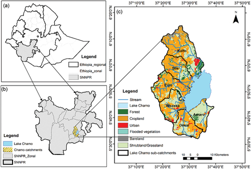
The study was conducted in the Southern Nations Nationalities and People’s Region (SNNPR), which is about 560 km to the south of Addis Ababa, the capital of Ethiopia. The study area, Lake Chamo catchment is located within the Ethiopian Rift Valley system comprising a total area of 1943 km2, which includes 329 km2 surface area of the lake. The Lake Chamo catchment comprises six sub-catchments comprising the Kulfo, Sile, Elgo, Wozeka, Dosie, and Amaro rivers (Zebire et al., Citation2019b). The catchment area is characterized by a humid to hot semi-arid tropical climate with a bimodal rainfall pattern of two wet seasons, one extending from the end of March to mid-June and the other from mid-September to late November (Wagesho, Citation2014). Due to the land use practice of steep-slope farming in the catchment, deforestation and land degradation is a major problems. As a result, the catchment faces a high risk of forest loss that threatens Lake Chamo with sedimentation (Teffera et al., Citation2017).
The country is restoring degraded landscapes as part of commitment to different international and national restoration pledges including the Bonn Challenge aiming to restore 15 million hectares of degraded landscape by 2030 (Pistorius & Freiberg, Citation2014). As part of this commitment, the country is working together with international organizations, NGOs, and the local community to restore the landscape with diverse plantation schemes and intensive tree plantation campaigns on communal lands of the area (Beyene & Shumetie, Citation2023). Hence, land use of the area has transformed in the past and it is in a continuous transformation. The selected study area is diverse in terms of land use practices because of the range of its agroecological zones from the highland to the lowland. Hence, the study area is representative of a diverse landscape where interest from the heterogonous farmers in the landscape is exercised. Furthermore, the landscape is in a continuous transformation as a result of land use changes.
The major land use in the catchment is agriculture with common crops like maize and sorghum in the lower catchment and irrigated banana and papaya fruits on the plains near the lake (Zebire et al., Citation2019a). The mid and high-altitude zones receive higher rainfall, up to 1,200 mm. According to the information provided by Geresse and Arbaminch Zuria districts, the primary means of livelihood revolves around engaging in mixed farming, predominantly focusing on cultivating maize and sorghum. Maize and sorghum are the most important staple food crops grown in the catchment (Zebire et al., Citation2019a). Maize grows in the highland and midland areas, while sorghum is most suited to the lowlands and midlands. The other annual crops grown in the area include teff, barley, wheat, pulses, oilseeds and vegetables. Enset, coffee and fruit trees are the most common perennial crops in the area (Ahimbisibwe et al., Citation2024). Among cash crops, fruit trees of banana and mango are by far the most important source of income in the lower catchment area (Gochera & Worku, Citation2022), while coffee is the second most important cash crop, it is most common in the upper and middle catchment areas. According to the information provided by Arbaminch Zuria district, a minority of the population is involved in fishing, selling fuelwood, gathering honey from forests, and engaging in small-scale trade to sustain their livelihoods.
The catchment area is mainly occupied by a rural settlement having Arbaminch city located 50 km away to the north part of the lower central catchment area. There are small semi-urban towns located within the lower catchment area called, Kolla Shelle and Zeyse Wozeka. Geresse (a major district town, which is also much larger) is situated at the uppermost part of the catchment area.
shows the location of the study area within the administrative boundary of Ethiopia; regional and zonal boundaries. The location map is integrated with the land use land cover map of the Environmental Systems Research Institute (ESRI) land use map of 2022. ESRI developed a standardized global land-use map with a fine resolution of 10 m, based on the European Space Agency (ESA) Sentinel-2 images with 86% accuracy in land-use classification. From ground observation, small patches of smallholder woodlot plantation and homestead agroforestry practices lie within the major cropland category. Furthermore, irrigated banana and papaya (perineal crops) are practised near Lake Chamo catchment in the Elgo and Sile catchment.
Figure 1. (a) Ethiopia with its regional and zonal administrative boundaries, (b) the southern nations, nationalities, and peoples’ region (SNNPR) displaying zonal administrative boundaries and the location of the Lake Chamo catchment, (c) the Lake Chamo catchment showing its sub-catchments and the land use and land cover of the study area. (source: own map).
2.2. Data collection methods and sampling procedures
We followed a mixed approach of quantitative and qualitative research methods to conduct the study. We collected primary data using field observation, Key Informant Interview (KII), household survey and Focus Group Discussion (FGD) from August to October 2022 in the Lake Chamo catchment area, Ethiopia. First, we conducted an exploratory field survey to identify the land use practices in the landscape. Two key informant interviews were conducted in Gerese and Arbaminch Zuria districts with the agriculture and natural resource management experts. We identified the major land use practices of sub-catchments and kebeles (the smallest administrative units) with diverse land use practices. Based on this, three sub-catchments, Sile, Elgo, and Wozeka were purposively selected due to their prospective representation of the diverse land use practices. Semi-structured interviews with key informants sought to identify the most common land use and farming system practices within the entire catchment and to identify those kebeles that fall in the selected catchments.
In the second stage, the selected sub-catchments were divided into three parts: upper, middle, and lower, based on the elevation difference following the river flow. Based on the inputs from the key informants, we selected kebeles systematically that show diverse land use system practices representing the catchment. The criteria we followed to select the kebeles were the representation of identified land use systems; these are woodlot, agroforestry, and crop-dominated kebeles with other secondary or tertiary land use practices, and spatial distribution in the catchment whereby, at least one kebele is selected from the three sub-catchments. Based on this, we selected 11 kebeles. (The selected kebeles and spatial distribution within the catchment are identified in the supplementary S1). To conduct the household survey, the sample size was determined using the formula by Cochran (Citation1977) (EquationEquation 1(1)
(1) ). We applied the proportion of smallholder farmers in Ethiopia (82%) (Bachewe & Taffesse, Citation2018; CSA, Citation2021).
Where n = desired sample size, z = Value of standard variation (1.96), e = Acceptable error (0.05), p = the proportion of the target population. The formula yielded a sample size of 228, which was adopted for final data collection.
Before conducting the actual household survey, a pre-test questionnaire was conducted on 10 randomly selected households in the study area. The test survey formed the basis for which land use practices by the smallholder farmers were categorized. Subsequently, four land use practices were selected including, crop, agroforestry, woodlot, and grazing. The crop land use category refers to land covered by annual crop production. The Agroforestry category comprises a mix of a perennial crop called enset, coffee, and shed trees such as Cordia Africana, which are the major agroforestry types in the upper and middle catchment whereas fruit trees with annual crops are the major agroforestry practices in the lower catchment. Woodlots are the land allocated for small patches of plantation forest, typically under Eucalyptus camaldulensis and Cupressus lusitanica species. Grazing land is land allocated explicitly to grow grass and fodder for livestock with either cut-and-carry systems or direct grazing. Then an extensive list of reasons for practising these land use, reasons for changing land use in the past, and influencing factors in the land use decisions were developed. Subsequently, a structured questionnaire was designed and applied to collect data from the 228 randomly selected households. Trained research assistants from Arbaminch University, Ethiopia together with the first author administered the questionnaire using a local language, Gamogna.
At the final stage of data collection, we conducted a Focus Group discussion (FGD) to deepen and verify findings on preferred land uses and farming system practices in the study area. A total of three FGDs in Gerese zala, Dembile Otora and Zeyse wozeka, (upper, middle and lower catchment areas) were conducted to elaborate on how the results from the individual household survey can better be interpreted when it comes to the land use decision-makers in the landscape. In each FGD, 16 participants, among which eight male and eight female participants discussed land use system components practised in the area and land use patterns of individual and collective land use practices. The discussants also identified and prioritized their most important land use practices from Agroforestry, woodlot, grazing land and cropland in case of constrained land size.
2.3. Description of variables
2.3.1. Livelihood assets and exogenous factors
Livelihood assets and exogenous factors that would affect the motivations of smallholder farmers to allocate land for different land use practices also influence land use decision and their attitude towards change. A review of meta-studies on land use science states that immediate causes of land use decision factors denote the outcomes of human decisions and underlying drivers constitute factors that affect these decisions (Van Vliet et al., Citation2016). The five livelihood capitals developed by DIFID (Citation1999), physical, natural, human, financial and social capitals were each assessed using two indicator variables. These variables were ranked on a 5-point Likert scale (Lissitz & Green, Citation1975; Ray, Citation1982). The indicators for each livelihood asset are as follows: i) physical capital is indicated by land tenure and road access; ii) natural capital indicators are the number of livestock and land size; iii) human capital indicators with labour and skilled people in the household; iv) financial capital indicators are saving and collateral; and v) social capital indicators are wealth status and social groups involvement. Similarly, the 5-point Likert scale was applied to identify the influencing variable among the exogenous factors in the area, which include policy, government push and project involvement.
2.3.2. Land use decision by farmers’ type
Several authors indicate that similar combinations of underlying drivers and biophysical conditions cannot be decisive factors toward similar land use transformations (Rudel et al., Citation2009; van Vliet et al., Citation2015). The variations are explained by the characteristics and attitudes of decision-makers who are the change agents (Malek et al., Citation2019; Van Vliet et al., Citation2016). Thereby, the research explores how different smallholder farmers decide to allocate land for certain land use practices. The ability of the farmers in land allocation for different land use practices is constrained by their ownership, which is their wealth status. Accordingly, three wealth classes among the sampled households were identified: rich, medium, and poor based on local wealth class standards (details on supplementary, S2), which consider the size of their land, ownership of cattle and housing to categorize farmers based on their wealth class. Then we used this household wealth status and carried out household categorization based on their orientation to change. Following the decision makers category by Malek et al. (Citation2019), the smallholder farmers were clustered as survivalist, subsistence-oriented and market-oriented.
According to this categorization, survivalist decision-makers are those with a primary objective of survival; thereby their ability and motivation to change land use are minimal. Subsistence-oriented farmers are those who perceive their land use beyond survival and aim toward gaining economic profit. This type of farmer is change-oriented with better ability and motivation toward land use change and diversification based on the household’s need and the market value of products. Market-oriented farmers are those with a higher ability to use their land to gain economic profit. This type of farmer is change-oriented and normally has a financial underpinning. For subsistence-oriented smallholder farmers, survival is their primary concern, but they also aim to achieve economic gains. Survivalist households are the most conservative of all types and are less likely to change their land use. Based on the data collected from the household survey, smallholder farmers were clustered in these three categories based on their wealth status, whether they had changed their land use in the last 5 years or not and what the triggering factor for the change was (aspiring economic benefit or a decline in soil fertility). shows the detailed procedure of clustering the farmers.
Table 1. Categorization of land use decision makers based on their ability and objective of land use transformation.
2.3.3. Ability of farmers in land use transformation and decision on FLR option
Farmers’ ability was defined to evaluate how land use decisions of smallholder farmers and decisions in transformation are related to their abilities, which is a combination of knowledge, skills and resources related to the management of their agricultural land optimal productivity, sustainability and economic viability. Hence, we defined the age, the level of education and the gender of the household head following Nyssen et al. (Citation2009) and Senkondo (Citation2000) alongside land size and number of livestock in terms of Tropical Livestock Unit (TLU) as explanatory variables (Mulu et al., Citation2022; Nyssen et al., Citation2009). Furthermore, we included the biophysical characteristics of the environment explained by the location of the farm household within the catchment, as these have the potential to influence their ability to transform (Mulu et al., Citation2022; Nigussie et al., Citation2017).
To analyse farmers’ abilities and objectives in land use decisions and transitions to FLR options, we examined variables related to household characteristics and endowments. We characterized households based on the gender, education level, and age of the household head. We assessed household endowments by considering the available land size and the number of livestock owned, measured in Tropical Livestock Units (TLU). These factors influence farmers’ capacity to allocate and transform land uses. Additionally, we linked the farm’s biophysical characteristics to its location within the catchment area, categorizing them as upper, middle, or lower. These factors were analysed to identify which variables affect the land use decision of the household especially to plant woodlots on their farmland and practice agroforestry, as these suggest FLR implementation by the smallholder farmers.
The intended objectives and decision factors behind transforming land use and farm practices about economic, environmental, social and institutional factors were identified. Consequently, we employed indicator variables; direct economic benefit (Mulu et al., Citation2022; Nigussie et al., Citation2017), decline in soil fertility (Mulu et al., Citation2022), available family labour (Ahimbisibwe et al., Citation2019) as well as engagement with policies and projects (Githinji et al., Citation2023). Reasons associated with land use transformations are calculated only for those households that converted their land use within the past 5 years. The variables used in this research together with selected indicators and targeted analysis are presented in .
Table 2. Summary of explaining variables, indicators and analysis followed for the study.
2.4. Data analysis
The study analysed the livelihood assets and other exogenous factors (elaborated in ) as explanatory variables underlying how smallholder farmers in the area decide on certain types of land use practices. The results are presented using descriptive statistics. Analysis of Variance (ANOVA) was conducted to see the differences in land use decision-making between survivalists, subsistence-oriented, and market-oriented farmers toward land allocation of different land use types namely, woodlot, agroforestry, crop, and grazing land. The ANOVA results are presented using box plots to show the distribution of land use practices among the different categories of farmers.
We employed Logistic Regression (LR) to assess the relationship between the odds of the household’s decision to plant woodlots on their farmland and practice agroforestry which suggests FLR implementation is influenced by the household head’s age, gender and education alongside land holdings and livestock owned. LR is a machine learning regression technique that assesses the relationships between dependent variables (binary or continuous) and a set of independent variables (Peng et al., Citation2002).
Logistic Regression (LR) is well-suited for handling binary outcomes, even when the dependent variable does not follow a normal distribution. The model predicts the likelihood of a desired outcome based on given explanatory variables (the characteristics, of the household, endowments and location within the catchment), represented by the intercept (α), regression coefficients (β), and an error term (ε). By applying the Antilogarithm, the model forecasts the probability of the desired outcome (the probability of woodlot and agroforestry practices). Thereby, a Logistic regression model is fitted to analyse the effect of total land size, TLU, age, gender, and education status of the household head on land allocation of the smallholder farmers in implementing FLR options, woodlot plantation and agroforestry practice. The data were assessed for influenciality and multicollinearity using variance inflation factor and pairwise correlation, and no problem was detected. The results of the logistic regression model is presented using an odds ratio.
Land use changes that occurred in the past five years were identified together with the reasons for land use changes. A contingency table is used to analyse the correlation between different land use transformations that occurred in the past five years with the contributing factors of change: economic benefit, soil, labour, project involvement and policy. Results are presented using a contingency table and illustrated using a balloon plot. The data obtained in this study were analysed using the R software. The qualitative data obtained employing exploratory interviews and follow-up FGDs was analysed contextually in the interpretation of the results obtained from the household survey.
3. Results
3.1. Motivation of smallholder farmers derived by livelihood assets and exogenous factors
Livelihood assets and exogenous factors contribute to the farmer’s motivation in their land use allocation decisions. The result of the study indicates that natural capital and financial capital are recognized as the most influencing livelihood assets in household land use decisions while project involvement and policies are the most influencing exogenous factors. From the indicators of natural capital, land size ownership is the most influencing factor. About 81.5% of the total households rated the natural capital, designated by land size, as the most influencing factor of the five livelihood assets. Financial capital, designated by collateral, and physical capital, designated by road access, are the second and third most important aspects influencing land use decisions for 63% and 57% of smallholder farmers. Human capital designated by skilled people in the household and social capital designated by involvement in social groups were rated to be highly influencing factors by only 39% and 27% of the smallholder farmers, respectively.
The result reveals that land tenure, representing physical capital, is rated as not having much influence on household land use decisions (). This is due to the perception of the farmers that having a land certificate for their land means they own their land and it cannot influence them as long as it is under their ownership. On the other hand, 81% of the respondents believe that project involvement is the most influencing exogenous factor regarding household land use decisions. presents the influence level of the five livelihood assets and the exogenous factors on land use decisions by the sampled households.
Figure 2. Level of influence of livelihood assets and exogenous factors on land use decision of the household (source: own calculations, n = 228).
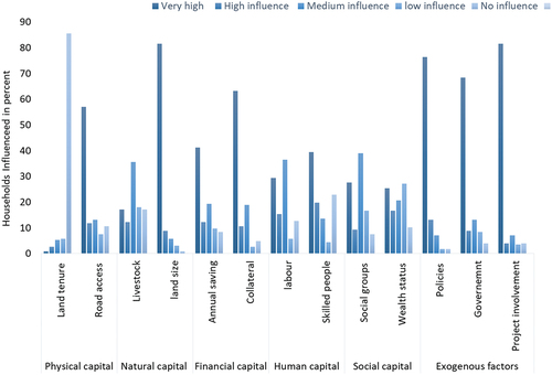
Project involvement has a very high influence on land allocation by smallholder farmers in the area. The FGD confirms that the implementation of FLR options by different stakeholders in the landscape has a high tendency to engage farmers in the restoration activities and allocate part of their land for woodlot plantation as part of a project initiative in addition to a personal decision to gain economic profit and supply their wood demand. It is also confirmed that policies and regulations imposed by the government play a significant role in influencing the land use decisions of farmers. Specifically, regulations related to land use practices based on the slope of the area tend to influence their decision. Furthermore, direct government monitoring and pushes to plant trees on farmers’ land are confirmed to highly influence the land use decisions of farmers.
3.2. Land use decisions and transformations by farmer type
Decision making of the selected four land use systems (cropland, agroforestry, woodlot and grazing land) is different among different farmers’ type expressed by their behaviour of change orientation. About 51% of the households in the case study area are survivalist, 23% subsistence-oriented, and 26% market-oriented. The ANOVA results (details on supplementary, S3) show a higher variation among the different land use decision-makers when it comes to land allocation for crops and grazing. Similarly, land allocation for agroforestry practice shows substantial variation among the decision makers; survivalist and subsistence-oriented, or market-oriented. However, land allocation for woodlot has no substantial variation among the land use decision-makers. This indicates that land allocation for woodlots in the catchment is not limited to a certain type of land use decision-makers.
Survivalist farmers allocate more land for woodlots in terms of size proportion. However, the average land size allocated for woodlots by subsistence-oriented and market-oriented farmers is higher than that of survivalists. Land allocation for agroforestry by the different categories of smallholder farmers shows that there is substantial variation between the three types of farmers. Subsistence-oriented farmers allocate more land for agroforestry, followed by market-oriented and survivalist groups. Land allocation for cropland highly differ among the different household groups. On average, more land is allocated for crops by market-oriented farmers, followed by survivalist farmers. Market-oriented farmers allocate on average 2 ha of land for crop production while subsistence-oriented and survivalist farmers allocate an average of 0.4 and 1.1 ha respectively. The result is highly associated with the reasons for land allocation for the different land uses. The result of ANOVA showing allocation of land to the four land uses by farmer type; survivalist, subsistence-oriented and market-oriented farmers is presented using a boxplot in .
Figure 3. Distribution of land use practices according to smallholder farmers group (n = 228).
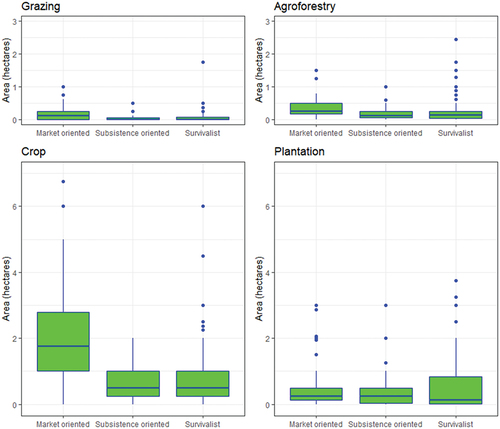
Land use allocation for grazing shows a substantial variation across the different farmer categories. Market-oriented farmers tend to allocate more land for grazing than survivalist or subsistence-oriented farmers. Despite the fact that land allocation for grazing is small, as compared to the other land uses, the variation among the different household categories is a result of livestock ownership.
Market-oriented farmers allocate more land for cropland than other land use practices targeting yearly based economic revenue whereas subsistence-oriented farmers distribute the land size fairly to the four land use practices. While the average land size dedicated to woodlots by survivalist farmers is smaller when compared to market-oriented and subsistence-oriented farmers, it is intriguing to note that survivalist farmers have more land allocated for woodlot plantations than market-oriented and subsistence-oriented farmers. This implies that the benefit associated with land use practices, high-value crops or trees, are driving factors for market-oriented and subsistence-oriented farmers to transform their land use practices.
3.3. Ability and objectives of smallholder farmers in decision-making of FLR options
The results from the logistic regression model are presented with an odds ratio of explaining variable to estimate the adoption of the two FLR options, woodlot and agroforestry practice by smallholder farmers at the 95% Confidence Interval (CI) (see ). The result shows that the location of the smallholder farmer is an important factor in predicting the odds of adopting woodlot and agroforestry practices. Being in the highland increases the likelihood of adopting woodlot by 2.15 times as compared to being located in the lowland. Similarly, being located in the highlands increases the adoption of agroforestry practices by almost 20-fold as compared to being located in the lowlands. The high odds of ratio for location underscores its crucial role in the adoption of agroforestry in the study area.
Table 3. Odds ratio of logistic regression model to predict woodlot and agroforestry practices.
Age and education of the household head are the minor variables to predict the adoption of woodlot and agroforestry. A household headed by a male has a slight increase in odds of adopting woodlot practice whereby it is associated with reducing the agroforestry practice by 86%. For each additional livestock expressed as TLU, there is a 15% increase in the odds of adopting agroforestry practice and this is associated with a slight reduction in the odds of practising woodlot. Similarly, each additional unit of land holding will increase the odds of adopting agroforestry practices and woodlot by 39% and 36% respectively. Thereby, larger land holdings are associated with higher odds of agroforestry practice and woodlot adoption. summarizes the result of the odds of land allocation for woodlots and agroforestry practices based on the location of the farm, farmers’ characteristics and their endowments.
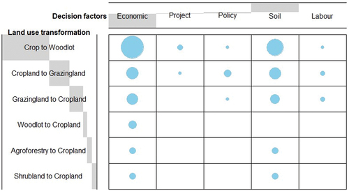
In addition to the land use practice that implicates FLR option in the area, we investigated which factors trigger farmers to transform their land use. It is found that 45% of the surveyed households have transformed their land use from one to the other in the last five years. presents the contributing factors of land use decision-making by these specific smallholder farmers. Economic factors, denoted as a direct economic benefit that the household gains from specific land use practices, act as a major pull factor toward changing land use practices of smallholder farmers. The economic factor was the biggest contributing factor in land use transformation from cropland to woodlot whereby soil fertility loss also contributes its part in this land use conversion. Thereby, the objective of the smallholder farmer to maximize economic benefit coupled with a decline in soil fertility contributes highly in the conversation of cropland to woodlot, which has a high implication on the practice of FLR options. shows the magnitude of factors underlying land use transformation. Institutional factors, such as policies related to slope-based farming restrictions have contributed to land use transformation, especially in the conversion of cropland to woodlot and grazing land. Furthermore, the involvement of households in FLR projects in the area contributed to the land use change decision from cropland to woodlot.
The specific land use decision factors have a varied influence on land use transformations for different households. Surprisingly, the study reveals that there is no land use transformation from other land uses toward agroforestry practice. This is because most of the agroforestry practices in the study area are inherited land use practices and there is no new agroforestry farm practice setup. However, the transformation from agroforestry to cropland due to intended economic benefit and better soil fertility that can increase productivity is. shows the magnitude of the contributing land use decision factors toward land use transformation.
Figure 4. Relationship between the decision factors behind land use transformation.
4. Discussion
Land size is the major influencing natural capital on land use decisions. Farmers indicated that they will only dedicate land for woodlot if they have sufficient land for crop production. The result form the survey show that farmers are influenced by financial capital in their land use decision. This has been recorded using if the land use decision is influenced if for example if trees are considered as collateral in household financial asset. It is noteworthy that 63% of the farmers consider this livelihood asset as a highly influential factor. Smallholder farmers would transform their land use from other land uses to woodlot even more than the current transformation if the government and other credit organizations recognized trees as financial assets. This implies that land allocation for woodlot plantations is constrained by the fact that trees are not considered collateral in Ethiopia. Similarly, other studies claim that trees are not considered, in financial terms, to be transactional assets (Starfinger et al., Citation2023). Tree collateral is rare in Africa, but there are many examples of it in Asian countries like China and Thailand (Starfinger, Citation2021; Starfinger et al., Citation2023). Financial assets, represented by collateral, are important decision factors to be considered in land use transformation, especially in applying FLR initiatives among smallholder farmers.
From the physical capital, road infrastructure is considered to be a livelihood asset influencing the motivation of smallholder farmers’ land use decisions especially in establishing woodlots. Similarly, studies point out that distance to roads and road infrastructures are factors influencing land use decisions toward woodlot plantations in Ethiopia (Mulu et al., Citation2022; Negussie, Citation2004). Human capital, represented by skilled people in the household, was also among the influencing factors of household land use decisions, which is in line with Prokopy et al. (Citation2019) which confirms, that individuals with formal education are better at using their human capital to minimize costs and increase the benefits associated with conservation. The study findings indicate that participation in various social groups has a high influence on household land use decisions. Farmers explain that social norms and bonds within the community are well established, which can facilitate increased information exchange that potentially influences each other in land use decisions. Similarly, Stedman (Citation2012) confirms that social and institutional structures can constrain or facilitate access to information and resources, thus shaping patterns of individual behaviour and social change.
Generally, all household categories tend to allocate land for all types of land uses. However, survivalist farmers have less land allocated for woodlots than for crops. This is due to their reduced motivations to change land uses from cropland to other land uses as their main objective is to feed their household. In most parts of Ethiopia, smallholder farmers are survivalist and subsistence-oriented, farming to secure food for household consumption with a major objective of satisfying household demand and, if possible, then supply the market. Market-oriented smallholder farmers are quite small in number as land ownership is not big enough to produce for a market with a profit-oriented attitude.
The results show that subsistence-oriented farmers who have changed their land use do so due to environmental, social, and, to some extent, economic factors. Subsistence-oriented farmers show better motivation to change land uses and they are open to trying different land use systems as they aim to market supply to a certain extent. The results reveal that, of the four selected land use systems, three land use practices; cropland, grazing, and agroforestry show extensive variation among the different categories of farmers. This is in line with (Bakker & van Doorn, Citation2009), which finds that different farmer types appear to have different preferences for land use and tend to make different land use changes. Farmers note that they allocate land for agroforestry to fulfil household food consumption and also to gain economic profit, especially from integrated perennial crops like coffee and the Cordia africana tree. Subsistence-oriented farmers are identified as those who are in transition to the market-oriented with an attitude of change (Malek et al., Citation2019). Thereby, there is a high likelihood of land use transformation from cropland to woodlot plantation seeking better economic profit in the area.
The land allocation for FLR options expressed as woodlot plantation and agroforestry were related to the location of the farm household within the catchment. The result is in line with Malek et al. (Citation2019), who concludes that land use changes are associated with environmental drivers or biophysical factors. As we move from the lower catchment to the upper catchment, the tendency to practice both FLR options is increasing. However this result does not mean that the two land use systems are non-existence in the lower catchment, they are less practised as compared to the upper catchment. The result is more related to the objective of the land use practice in the lower catchment is economic benefit as the environmental factor of decline in soil fertility is less of an issue in the lower catchment.
Land allocation for woodlot and agroforestry has been influenced by different factors. The results from the logistic regression highlight the importance of location of the farmers within the catchment in predicting the adoption of woodlot and agroforestry practices among smallholder farmers. The reduced woodlot practice in the midland catchment is due to high-value crops like teff and mung bean suited for the agroecological conditions, making the farmers lean toward crop production compared to the highland and lower catchment areas. Furthermore, the lower catchment is nourished by the potential irrigation-based banana and papaya plantation and cotton farming, which suit the agroecological zone of that altitude and temperature.
The odds of ratio explaining gender do not have a substantial influence on the odds of allocating land for woodlot and agroforestry practice. However, during the FGD, that female-headed households, where male members of the households are not capable of farming, are forced to change the land use from cropland to woodlot and agroforestry, both being less labour-intensive than crop production. Farmer’s characteristic expressed by their age, gender and education as well as endowment’s expressed with the livestock holdings do not influence the adoption of these FLR options. This suggests that FLR interventions aimed at promoting woodlot and agroforestry practices may need to consider geographical factors and land availability to be more effective.
Land size owned by the household shows a considerable relationship with whether the farmer would potentially allocate land for woodlot plantation or not. Households who own more land have much more ability to allocate land to woodlot. Similarly, studies point out that farmers with more land anticipate long-term profit than those who are constrained in terms of food production: those who must meet immediate household needs (Mulu et al., Citation2022; Negussie, Citation2004; Nigussie et al., Citation2017). The results from the FGD show that smallholder farmers allocate land for woodlot after securing land to produce crops, as well as spare land for grazing and agroforestry. This shows that allocating land for woodlots should not compete with their primary source of food production, which is cropland.
However, land allocation for agroforestry was not influenced by the land holding of the farmer. During FGD, it has been mentioned that households prefer to keep the land use practices that are inherited and deemed of cultural value like the homestead agroforestry practice. As a result, there was no transformation to and from agroforestry practice was observed within the specified period. The results from this study reveal that the amount of livestock owned by the household influences land allocation for agroforestry practices. This result is attributed to the fact that some of the products from the agroforestry practice like the enset leaf can used as livestock feed. A study in southern Ethiopia finds that enset leaf from homestead agroforestry is the main source of livestock feed (Eshetu et al., Citation2018). A study conducted in northern Ethiopia also confirms agroforestry systems are a source of livestock feed, especially during the dry season (Zeratsion et al., Citation2023).
Even though the result does not show a considerable influence of the education level of the household head on the tendency to allocate land for woodlot plantations and agroforestry practices, a study by Briassoulis (Citation2009) shows education, employment, attitudes toward change, and values are mentioned as factors influencing the choice of a household to change land use. It is also known that conservation decisions on private land are typically made by individuals who hold different assets, experiences, attitudes, and values (Epanchin-Niell et al., Citation2022). The study results depict that 55% of the households living in the catchment did not transform their land use between the specified periods of the study, 2018–2022. However, households may have altered their land use prior to the study period.
For the land use transformations that occurred in the past five years, the household ability to allocate land and other resources for certain land use practice and their objective, like attaining economic profit were the major factors for the change. This research depicts that economic drivers are the most important factor in land use transformation, especially in transforming from cropland to woodlot plantation. Similarly, studies find that the economic factor is the most important factor for land use decision-making (Groeneveld et al., Citation2017). Studies in northern Ethiopia reveal that farmers converted land that is suitable for crop production to eucalyptus plantations to achieve higher financial returns (Matthies & Karimov, Citation2014; Mulu et al., Citation2022). However, the study also confirms that some households reverted land use from woodlot plantation to cropland claiming economic factors, just in reverse: there is a longer waiting period for harvesting woodlot than for the annual harvest of croplands. This synthesis reflects that economic objectives and financial ability are important factors in the decision-making process of land use transformation. However, environmental factors like soil fertility loss play an important role in land use conversions from cropland to woodlot plantations.
According to this study, the environmental factor, expressed as the soil fertility level is the second influencing variable to transform the land use after attaining economic profit, especially from cropland to woodlot and grazing land due to a loss of soil fertility and associated loss in crop productivity. This implies that the influence of environmental factors on land use decisions is not negligible. Similarly, a study conducted in Northern Ethiopia shows that the conversion of cropland to eucalyptus woodlot plantation is expanding on degraded land where soil erosion is problematic (Matthies & Karimov, Citation2014).
The study result shows that the available labour within the household and the required labour for the land use practice implies the land use transformation. According to the FGD, female-headed households are influenced to transform their land use from cropland to woodlot or grazing land due to intensive labour requirements for crop production. The institutional factor expressed as land use-related policies is influencing the land use transformation to a certain extent, especially in the conversion of cropland to woodlot and grazing land. The rural land proclamation, which came into force in 2005 can affect land use decisions of smallholder farmers through regulation of slope-based farming practices. Policies and regulations imposed especially the restriction of conditional farming on slopes greater than 30% and strictly forbidden farming on lands above 60% slopes highly influence the decision of farmers. However, instead of restricting sloppy lands from cropping, land use options such as agroforestry and plantation should be explicitly indicated to restore degraded landscapes and achieve the FLR target of the country.
5. Conclusion
This study investigated the driving factors and reasons for the land use transformation of the Lake Chamo catchment in southern Ethiopia. Individual land decisions by smallholder farmers cumulatively impact land use transformations at the landscape level. Ultimately, the land use decisions of smallholder farmers are impacted by the resource endowments, the gender of the household head and the location of the farm within the catchment. The current land use transformation toward plantation by smallholder farmers has higher implications for the FLR of Lake Chamo catchment for achieving the FLR goal of the country at large. Even though the abilities of smallholder farmers in land use decisions and transformation are similar, the attitude and objectives of the farmers lead to diverse land use systems at the farm level, which has a cumulative impact on landscape transformation. Government pushes and development projects in the landscape influence the ability, motivation, and attitude of the farmers to adopt woodlot plantations, thus triggering change.
The study reveals that the direct economic contribution of plantation is replacing crop production on sloppy land where soil fertility has deteriorated. This contributes positively to agroforestry and plantation practices on smallholder farmers’ land. FLR implementers, especially the government, often miss the economic factor when selecting tree species, which is the major decision factor for smallholder farmers. Therefore, the implementation of FLR in the study area and elsewhere in similar landscapes, where smallholder farmers are targeted to be involved, should highly consider promoting economically rewarding tree species. Furthermore, tree species that can be intercropped, such as fruit trees that can contribute directly to the food consumption of households should be given priority when approaching survivalist farmers to engage in FLR.
As the biophysical factors related to the catchment location and slope are important, further research must be conducted on how land use can be better optimized to fulfil the feasible economic revenue maximization of smallholder farmers while keeping the landscape environmentally viable and socially sound. Furthermore, land use is influenced by different stakeholders engaged in the landscape with varying intentions of implementing FLR. Therefore, a comprehensive land use decision tool that can be used in land use planning is vital.
Geolocation information
The study is conducted in Southern Ethiopia located: 37°13`E to 37° 40È longitude and 05°32´ N to 06° 55`N latitude.
Supplementary_3.docx
Download MS Word (14.3 KB)Acknowledgment
We would like to thank the farmers who participated in the survey and the enumerators participated in data collection (Samson Tsegaye, Wondimagegn Elias, Tesfaye Teka and Habtamu Abebe) who interpreted the survey questionnaire to the farmers in the local language, Gamognna.
Disclosure statement
No potential conflict of interest was reported by the author(s).
Supplementary Material
Supplemental data for this article can be accessed online at https://doi.org/10.1080/1747423X.2024.2386989
Additional information
Funding
References
- Abdi, D., & Gebrekristos, S. (2022). Regionalization of low flow analysis in data scarce region: The case of the lake abaya-chamo sub-basin, Rift Valley Lakes basin, Ethiopia. Journal of Water Management Modeling. https://doi.org/10.14796/jwmm.c487
- Ahimbisibwe, V., Balaba Tumwebaze, S., Berger, U., Groeneveld, J., & Berger, U. (2019). Drivers of household decision-making on land-use transformation: An example of woodlot establishment in Masindi District, Uganda. Forests, 10(8), 619. https://doi.org/10.3390/f10080619
- Ahimbisibwe, V., Zhunusova, E., Kassa, H., & Günter, S. (2024). Technical efficiency drivers of farmer-led restoration strategies, and how substantial is the unrealised potential for farm output? Agricultural Systems, 213, 103799. https://doi.org/10.1016/j.agsy.2023.103799
- Ariti, A.T., van Vliet, J., & Verburg, P.H. (2018). Farmers’ participation in the development of land use policies for the Central Rift Valley of Ethiopia. Land Use Policy, 71, 129–137. https://doi.org/10.1016/j.landusepol.2017.11.051
- Bachewe, F.N., & Taffesse, A.S. (2018). Supply response of smallholder households in Ethiopia. IFPRI, Chapter 7 (pp. 181–203). https://doi.org/10.2499/9780896292833_08
- Bakker, M.M., & van Doorn, A.M. (2009). Farmer-specific relationships between land use change and landscape factors: Introducing agents in empirical land use modelling. Land Use Policy, 26(3), 809–817. https://doi.org/10.1016/j.landusepol.2008.10.010
- Beatty, C.R., Vidal, A., Devesa, T., & Kuzee, M.E. (2020). Accelerating biodiversity commitments through forest landscape restoration.
- Bennett, N.J., Roth, R., Klain, S.C., Chan, K., Christie, P., Clark, D.A., Cullman, G., Curran, D., Durbin, T.J., Epstein, G., Greenberg, A., Nelson, M.P., Sandlos, J., Stedman, R., Teel, T.L., Thomas, R., Veríssimo, D., & Wyborn, C. (2017). Conservation social science: Understanding and integrating human dimensions to improve conservation. Biological Conservation, 205, 93–108. https://doi.org/10.1016/j.biocon.2016.10.006
- Beyene, A.D., & Shumetie, A. (2023). Green legacy initiative for sustainable economic development in Ethiopia. Ethiopian Economic Association (EEA).
- Briassoulis, H. (2009). Land Cover Land use and the Global Change. In W. H. Verheye (Eds.), Encyclopaedia of Land Use Land Cover and Soil Science (Vol. 1, pp. 126–146). United Kingdom: ELOSS publisher/UNESCO.
- Clement, F., & Amezaga, J.M. (2008). Linking reforestation policies with land use change in northern Vietnam: Why local factors matter. Geoforum; Journal of Physical, Human, and Regional Geosciences, 39(1), 265–277. https://doi.org/10.1016/j.geoforum.2007.05.008
- Cochran, W.G. (1977). Sampling techniques. john wiley & sons.
- Crossman, N.D., Bryan, B.A., de Groot, R.S., Lin, Y.-P., & Minang, P.A. (2013). Land science contributions to ecosystem services. Current Opinion in Environmental Sustainability, 5(5), 509–514. https://doi.org/10.1016/j.cosust.2013.06.003
- CSA. (2021, September – December). Agricultural sample survey, 2021/22 (2014 E.C.), Ethiopian central statistics agency, VOLUME I E. C. S. agency. Retrieved Semptember , 2023, from. https://www.statsethiopia.gov.et/wp-content/uploads/2021/05/2013-MEHER-REPORT.FINAL_.pdf
- DIFID. (1999). Sustainable-livelihoods-guidance-sheet-Section1. Retrieved April , 2022, from https://www.ennonline.net/attachments/871/dfid-sustainable-livelihoods-guidance-sheet-section1.pdf
- Epanchin-Niell, R.S., Jackson-Smith, D.B., Wilson, R.S., Ashenfarb, M., Dayer, A.A., Hillis, V., Iacona, G.D., Markowitz, E.M., Marquart-Pyatt, S.T., & Treakle, T. (2022). Private land conservation decision-making: An integrative social science model. The Journal of Environmental Management, 302, 113961. https://doi.org/10.1016/j.jenvman.2021.113961
- Eshetu, S., Pretzsch, J., & Mekonnen, T. (2018). Financial analysis of smallholder farmers woodlot and homestead agroforestry systems and its implications for household income improvement, the case of Hawassa Zuria District, Southern Ethiopia. Journal of Agricultural Science and Food Research, 9(236), 2.
- Gebre, S.L., Cattrysse, D., Alemayehu, E., & Van Orshoven, J. (2021). Multi-criteria decision making methods to address rural land allocation problems: A systematic review. International Soil & Water Conservation Research, 9(4), 490–501. https://doi.org/10.1016/j.iswcr.2021.04.005
- Geist, H.J., & Lambin, E.F. (2002). Proximate causes and underlying driving forces of tropical DeforestationTropical forests are disappearing as the result of many pressures, both local and regional, acting in various combinations in different geographical locations. BioScience, 52(2), 143–150. https://doi.org/10.1641/0006-3568(2002)052[0143:PCAUDF]2.0.CO;2
- Githinji, M., van Noordwijk, M., Muthuri, C., Speelman, E.N., & Jan Hofstede, G. (2023). Farmer land-use decision-making from an instrumental and relational perspective. Current Opinion in Environmental Sustainability, 63, 101303. https://doi.org/10.1016/j.cosust.2023.101303
- Gochera, A., & Worku, H. (2022). Mangifera indica (L.) tree as agroforestry component: Environmental and socio-economic roles in Abaya-Chamo catchments of the southern rift valley of Ethiopia. Cogent Food & Agriculture, 8(1). https://doi.org/10.1080/23311932.2022.2098587
- Groeneveld, J., Müller, B., Buchmann, C.M., Dressler, G., Guo, C., Hase, N., Hoffmann, F., John, F., Klassert, C., Lauf, T., Liebelt, V., Nolzen, H., Pannicke, N., Schulze, J., Weise, H., & Schwarz, N. (2017). Theoretical foundations of human decision-making in agent-based land use models – a review. Environmental Modelling & Software, 87, 39–48. https://doi.org/10.1016/j.envsoft.2016.10.008
- Kassa, H., Abiyu, A., Hagazi, N., Mokria, M., Kassawmar, T., & Gitz, V. (2022). Forest landscape restoration in Ethiopia: Progress and challenges. Frontiers in Forests and Global Change, 5. https://doi.org/10.3389/ffgc.2022.796106
- Lissitz, R.W., & Green, S.B. (1975). Effect of the number of scale points on reliability: A monte carlo approach. Journal of Applied Psychology, 60(1), 10. https://doi.org/10.1037/h0076268
- Malek, Ž., Douw, B., Van Vliet, J., Van Der Zanden, E.H., & Verburg, P.H. (2019). Local land-use decision-making in a global context. Environmental Research Letters, 14(8), 083006. https://doi.org/10.1088/1748-9326/ab309e
- Matthews, R. (2006). The people and landscape model (PALM): Towards full integration of human decision-making and biophysical simulation models. Ecological Modelling, 194(4), 329–343. https://doi.org/10.1016/j.ecolmodel.2005.10.032
- Matthies, B.D., & Karimov, A.A. (2014). Financial drivers of land use decisions: The case of smallholder woodlots in amhara, Ethiopia. Land Use Policy, 41, 474–483. https://doi.org/10.1016/j.landusepol.2014.06.012
- Müller, B., Bohn, F., Dreßler, G., Groeneveld, J., Klassert, C., Martin, R., Schlüter, M., Schulze, J., Weise, H., & Schwarz, N. (2013). Describing human decisions in agent-based models – ODD + D, an extension of the ODD protocol. Environmental Modelling & Software, 48, 37–48. https://doi.org/10.1016/j.envsoft.2013.06.003
- Müller-Hansen, F., Schlüter, M., Mäs, M., Donges, J.F., Kolb, J.J., Thonicke, K., & Heitzig, J. (2017). Towards representing human behavior and decision making in Earth system models – an overview of techniques and approaches. Earth System Dynamics, 8(4), 977–1007. https://doi.org/10.5194/esd-8-977-2017
- Mulu, S., Asfaw, Z., Alemu, A., & Teketay, D. (2022). Determinants of decision making by smallholder farmers on land allocation for small-scale forest management in northwestern Ethiopian highlands. The Land, 11(6), 838. https://doi.org/10.3390/land11060838
- Negussie, A.D. (2004). Farm forestry d ecision making strategies of the Guraghe households, southern-central highlands of Ethiopia Zugl.: Dresden, Techn. Univ. Diss. 2004.
- Nigussie, Z., Tsunekawa, A., Haregeweyn, N., Adgo, E., Nohmi, M., Tsubo, M., Aklog, D., Meshesha, D.T., & Abele, S. (2017). Factors affecting small-scale farmers’ land allocation and tree density decisions in an Acacia decurrens-based taungya system in Fagita Lekoma District, North-Western Ethiopia. Small-Scale Forestry, 16(2), 219–233. https://doi.org/10.1007/s11842-016-9352-z
- Nyssen, J., Simegn, G., & Taha, N. (2009). An upland farming system under transformation: Proximate causes of land use change in Bela-Welleh catchment (wag, northern Ethiopian highlands). Soil and Tillage Research, 103(2), 231–238. https://doi.org/10.1016/j.still.2008.05.020
- Peng, C.-Y., Lee, K.L., & Ingersoll, G.M. (2002). An introduction to logistic regression analysis and reporting. J Educ Res, 96, 3–14. https://doi.org/10.1080/00220670209598786
- Pistorius, T., Carodenuto, S., & Wathum, G. (2017). Implementing forest landscape restoration in Ethiopia. Forests, 8(3), 61. https://doi.org/10.3390/f8030061
- Pistorius, T., & Freiberg, H. (2014). From target to implementation: Perspectives for the international governance of forest landscape restoration. Forests, 5(3), 482–497. https://doi.org/10.3390/f5030482
- Polasky, S., Carpenter, S.R., Folke, C., & Keeler, B. (2011). Decision-making under great uncertainty: Environmental management in an era of global change. Trends in Ecology & Evolution, 26(8), 398–404. https://doi.org/10.1016/j.tree.2011.04.007
- Poppenborg, P., & Koellner, T. (2013). Do attitudes toward ecosystem services determine agricultural land use practices? An analysis of farmers’ decision-making in a South Korean watershed. Land Use Policy, 31, 422–429. https://doi.org/10.1016/j.landusepol.2012.08.007
- Prokopy, L.S., Floress, K., Arbuckle, J.G., Church, S.P., Eanes, F.R., Gao, Y., Gramig, B.M., Ranjan, P., & Singh, A.S. (2019). Adoption of agricultural conservation practices in the United States: Evidence from 35 years of quantitative literature. Journal of Soil and Water Conservation, 74(5), 520–534. https://doi.org/10.2489/jswc.74.5.520
- Ray, J.J. (1982). The construct validity of balanced likert scales. The Journal of Social Psychology, 118(1), 141–142. https://doi.org/10.1080/00224545.1982.9924431
- Rudel, T.K., Defries, R., Asner, G.P., & Laurance, W.F. (2009). Changing drivers of deforestation and new opportunities for conservation. Conservation Biology, 23(6), 1396–1405. https://doi.org/10.1111/j.1523-1739.2009.01332.x
- Scoones, I. (2009). Livelihoods perspectives and rural development. The Journal of Peasant Studies, 36(1), 171–196. https://doi.org/10.1080/03066150902820503
- Senkondo, E.M. (2000). Risk attitude and risk perception in agroforestry decisions: The case of Babati, Tanzania. Wageningen University and Research.
- Sikor, T. (2001). The allocation of forestry land in Vietnam: Did it cause the expansion of forests in the northwest? Forest Policy and Economics, 2(1), 1–11. https://doi.org/10.1016/S1389-9341(00)00041-1
- Stanturf, J.A., Kleine, M., Mansourian, S., Parrotta, J., Madsen, P., Kant, P., Burns, J., & Bolte, A. (2019). Implementing forest landscape restoration under the Bonn challenge: A systematic approach. Annals of Forest Science, 76(2). https://doi.org/10.1007/s13595-019-0833-z
- Starfinger, M. (2021). Financing smallholder tree planting: Tree collateral & Thai ‘tree banks’ - collateral 2.0? Land Use Policy, 111, 105765. https://doi.org/10.1016/j.landusepol.2021.105765
- Starfinger, M., Tham, L.T., & Tegegne, Y.T. (2023). Tree collateral – a finance blind spot for small-scale forestry? A realist synthesis review. Forest Policy and Economics, 147, 102886. https://doi.org/10.1016/j.forpol.2022.102886
- Stedman, R.C. (2012). Sociological considerations in wildlife management [article]. Human dimensions of wildlife management. (58–67). https://www.scopus.com/inward/record.uri?eid=2-s2.0-84897875201&partnerID=40&md5=2ce805d559fe0c05f63a0d00e029f0ab
- Teffera, F.E., Lemmens, P., Deriemaecker, A., Brendonck, L., Dondeyne, S., Deckers, J., Bauer, H., Gamo, F.W., & De Meester, L. (2017). A call to action: Strong long-term limnological changes in the two largest Ethiopian rift Valley lakes, Abaya and Chamo. Inland Waters, 7(2), 129–137. https://doi.org/10.1080/20442041.2017.1301309
- Valbuena, D., Verburg, P.H., Bregt, A.K., & Ligtenberg, A. (2010). An agent-based approach to model land-use change at a regional scale. Landscape Ecology, 25(2), 185–199. https://doi.org/10.1007/s10980-009-9380-6
- van Vliet, J., de Groot, H.L.F., Rietveld, P., & Verburg, P.H. (2015). Manifestations and underlying drivers of agricultural land use change in Europe. Landscape and Urban Planning, 133, 24–36. https://doi.org/10.1016/j.landurbplan.2014.09.001
- Van Vliet, J., Magliocca, N.R., Büchner, B., Cook, E., Rey Benayas, J.M., Ellis, E.C., Heinimann, A., Keys, E., Lee, T.M., Liu, J., Mertz, O., Meyfroidt, P., Moritz, M., Poeplau, C., Robinson, B.E., Seppelt, R., Seto, K.C., & Verburg, P.H. (2016). Meta-studies in land use science: Current coverage and prospects. AMBIO: A Journal of the Human Environment, 45(1), 15–28. https://doi.org/10.1007/s13280-015-0699-8
- Verburg, P.H., Neumann, K., & Nol, L. (2011). Challenges in using land use and land cover data for global change studies. Global Change Biology, 17(2), 974–989. https://doi.org/10.1111/j.1365-2486.2010.02307.x
- Wagesho, N. (2014). Catchment dynamics and its impact on runoff generation: Coupling watershed modelling and statistical analysis to detect catchment responses. International Journal of Water Resources and Environmental Engineering, 6(2), 73–87. https://doi.org/10.5897/IJWREE2013.0449
- Wiegant, D., Mansourian, S., Eshetu, G.Z., & Dewulf, A. (2023). Cross-sector challenges in Ethiopian forest and landscape restoration governance. Environmental Science & Policy, 142, 89–98. https://doi.org/10.1016/j.envsci.2023.02.003
- Wise, M., Calvin, K., Thomson, A., Clarke, L., Bond-Lamberty, B., Sands, R., Smith, S.J., Janetos, A., & Edmonds, J. (2009). Implications of limiting CO2 concentrations for land use and energy. Science, 324(5931), 1183–1186. https://doi.org/10.1126/science.1168475
- Zebire, D.A., Ayele, T., & Ayana, M. (2019a). Characterizing soils and the enduring nature of land uses around the Lake Chamo Basin in South-West Ethiopia. Journal of Ecology and Environment, 43(1). https://doi.org/10.1186/s41610-019-0104-9
- Zebire, D.A., Ayele, T., & Ayana, M. (2019b). Characterizing soils and the enduring nature of land uses around the Lake Chamo Basin in South-West Ethiopia. Journal of Ecology and Environment, 43(1), 15. https://doi.org/10.1186/s41610-019-0104-9
- Zeratsion, B.T., Manaye, A., Gufi, Y., Tesfaye, M., Werku, A., & Anjulo, A. (2023). Agroforestry practices for climate change adaptation and livelihood resilience in drylands of Ethiopia. Forest Science and Technology, 20(1), 1–11. https://doi.org/10.1080/21580103.2023.2292171